Abstract
Adaptation at actively receding coastal areas requires swift and long-term solutions that build resilience for both people and the environment. Nature-based solutions are increasingly being promoted over hard defences, but there is a lack of empirical research on the effectiveness of novel approaches, including those deployed at different scales. Sandscaping, a one-off large-scale deposition of sand (1.8 M m3) on a beach frontage, was implemented for the first time in the UK at a section of beach between Bacton and Walcott villages, in North Norfolk, in 2019. The purpose of sandscaping in this location was primarily to protect the nationally important gas terminal, and neighbouring villages from coastal erosion and flooding. This study investigates the perceived effectiveness and impacts of sandscaping on coastal residents, by eliciting views of residents in the two closest villages to the scheme, and comparing findings to geomorphological observations (using LiDAR data). A survey of Bacton and Walcott residents was distributed in January 2022, with n=77 responses. Results reveal wide differences in perceptions, and notable levels of doubt, on the ‘effectiveness’ of sandscaping at present and in the future, alongside different lived experiences of the scheme and prevailing distrust by some residents about coastal management. Keeping residents updated on changes to sandscaping with environmental data and communicating the advantages of nature-based solutions appear relevant in this context, but the diversity and contrast of resident perceptions illustrates deeper challenges for future coastal management planning. There is a need to think through how future coastal change can be planned for, drawing upon multiple social perspectives. This paper also illustrates that ‘effectiveness’ of sandscaping should be more widely examined in relation to the experiences and perspectives of those impacted by the scheme, and beyond evaluations of geomorphological change.
1 Introduction
Increasingly, coastal areas of the UK are facing multiple challenges, including from climate change, which has led to calls for greater attention given to adaptation and innovative strategies. Historically hard defences, such as groynes and sea walls, were predominately used in England to manage the risk of coastal erosion. Since 2005’s Making Space for Water policy, nature-based solutions have risen in use (Buser, 2020). In England, for example, these are strongly advocated by the current Environment Agency (2020) Flood and Coastal Erosion Risk Management Road Map. Nature-based solutions enhance natural coastal features, and for eroding coastal areas vulnerable to storms, they utilize natural coastal processes to dissipate the energy of waves (Moller et al., 2014) reducing the risk of overtopping and cliff scour. Nature-based solutions can also be used in combination with, or to support, climate change adaptation (Nature-Based Solutions Initiative, 2022). The two main types of nature-based solutions used on UK coasts are beach nourishment, and restoring coastal ecosystems (such as saltmarshes) (POST, 2021). More recently, such strategies have become increasingly innovative, with mega-nourishment (in Norfolk, 2019) and coastal wetland restoration (in Essex, 2018) becoming the largest-scale implementation of their kind in England (RSPB, 2018; Johnson et al., 2020, respectively). Given their novel approach and scale, understanding whether innovative nature-based solutions are effective – or not – is now critical to informing the roll-out of similar schemes in the future.
The Intergovernmental Panel on Climate Change (IPCC)’s sixth assessment report (2022, p.49) argues that adaptation should be “effective, feasible and conforms to the principles of justice”. The report (ibid) uses a broad definition of adaptation ‘effectiveness’ as “the extent to which an action reduces vulnerability and climate-related risk, increases resilience, and avoids maladaptation”. Meanwhile, the legally binding Paris Agreement (United Nations, 2015, p.1) calls on nation states to undertake “an effective and progressive response to the urgent threat of climate change”, alongside a global goal for adaptation. The concept of ‘effectiveness’ is therefore an important one in evaluating adaptation strategies. However, there is no widely accepted and applied understanding of adaptation ‘effectiveness’ because of the variety of scales, local context, and range of academic disciplines with which it is studied (Dilling et al., 2019; Owen, 2020; Singh et al., 2021). Furthermore, there are numerous potential goals of adaptation (Singh et al., 2021), and the decision of who or what to adapt, and where and why, is highly subjective according to individual judgement and context-specific factors, raising justice implications on how adaptation strategies are designed and implemented (Dilling et al., 2019; Owen, 2020; Singh et al., 2021). Owen (2020)’s systematic review on adaptation practices globally points to six aspects of adaptation effectiveness: increased resilience, wellbeing, adaptive capacity and social/natural system functioning; or reduced vulnerability or climate impact (several of these aspects are present in the IPCC’s (ibid) definition). There exists other work in literature exploring adaptation effectiveness (for example Doswald et al., 2014, looking at ecosystem-based adaptation) or ‘successful’ adaptation (for example Adger et al., 2015). This literature is drawn upon here to consider the implications for both social and natural systems when evaluating the effectiveness of coastal management strategies.
To date, existing ex-post research on beach nourishment and larger-scale ‘mega-nourishment’ focuses on the geomorphological response of the coastal system. It therefore considers ‘effectiveness’ in terms of how such schemes reduce physical coastal flooding or erosion risk (Stive et al., 2013; de Schipper et al., 2016; Hoonhout and de Vries, 2017; Luijendijk et al., 2017; Martell et al., 2020; Bolle et al., 2020; Roest et al., 2021). This view of coastal management ‘effectiveness’ does not consider social factors, as proposed by the IPCC (2022). In fact, de Schipper et al. (2021) propose that beach nourishment evaluations need to go beyond geomorphology, to a more holistic consideration of social, economic and environmental impacts. In terms of social impacts, the authors (ibid) highlight the impact of beach nourishment on recreational use of the coast, tourism, and property prices. Local stakeholders may be impacted in other ways aside from recreational use, and this paper seeks to understand the range of social impacts residents may experience. This paper also argues that to evaluate mega-nourishment also requires an understanding of how ‘effectiveness’ is understood by local residents and stakeholders.
While public perceptions of beach nourishment have been well studied (for example Lozoya et al., 2014; Prati et al., 2016; Cabezas-Rabadán et al., 2019), research with policy-makers, stakeholder organizations (Ariza et al., 2014; Bontje et al., 2019), and recreational beach users (Cabezaz-Rabadán et al., 2019; Usher, 2021) is more extensive compared with local residents. Research indicates a divergent range of views amongst stakeholders, particularly on what the objectives of beach nourishment should be (Ariza et al., 2014; Prati et al., 2016). Prati et al. (2016) found that local stakeholders (that use, work near or study the nourished beaches of Portonovo Bay, Italy) who perceive erosion as a strongly negative process were more likely to support beach nourishment and were less concerned about any negative impacts. Further, Usher’s (2021) survey of recreational surfers in Virginia, US, found varying perceptions in different areas, with more negative perceptions for beaches that have been more heavily nourished, suggesting beach nourishment has a greater impact on wave quality for surfers over time. Marin et al. (2009) explored local residents’ perceptions of locally nourished beaches in northern Italy, finding low levels of awareness, with over half of respondents having not previously heard of beach nourishment. Of those aware of the scheme, 56% had negative perceptions of it, due to changes in sand grain size, and concerns over project cost, effectiveness (in achieving its objectives), and water quality. Other negative perceptions of beach nourishment by local residents include disliking wider beaches, despite the overall benefit of increased beach size (in Gold Coast, Australia) (Todd and Bowa, 2016). There are no studies to date on local residents’ perceptions of larger-scale mega-nourishment schemes, with existing social research focusing instead on its unique governance and partnership approach (Vikolainen et al., 2017; Clipsham et al., 2018; Johnson et al., 2020) or from the perspective of specific recreational users, such as wild swimmers (Radermacher, 2018).
Aside from beach nourishment, there have been several studies on public perceptions of other coastal nature-based solutions. McKinley et al’s. (2020) national public survey of saltmarshes in Wales found uncertainty about their function and purpose: 15-40% of respondents selected ‘unsure’, when asked a series of questions on different benefits of saltmarshes. Roca and Villares (2012) also found low levels of knowledge on managed realignment amongst stakeholders who work or use the Ebra Delta in Spain, alongside a diversity of opinions and low trust in policymakers. Studies on nourishment or nature-based solutions consider ‘effectiveness’ largely in terms of reduced coastal risk or increase coastal protection (Roca and Villares, ibid; Gray et al., 2017; Anderson and Renaud, 2021). Roca and Villares (ibid) found that over 70% of stakeholders surveyed perceive a strategy of managed realignment as less effective (in reducing coastal erosion risk) than hard defences. Gray et al. (2017)’s interviews with coastal residents in the US state of New Jersey similarly revealed a perception that hard defences are more effective than natural infrastructure (i.e., nature-based solutions such as dunes), which suggests hard defences may be the preferred option to manage coastal change. Anderson and Renaud (2021) argue that nature-based solutions are ‘judged’ to a higher standard (for example in terms of effectiveness, value for money, impacts) than hard defences, and that policymakers need to sell the benefits of nature-based solutions more persuasively. This is particularly crucial in a coastal context, where hard defences can increase the risk of erosion for adjacent coastal areas, and therefore are not always a viable option (French, 2004). However, the method of communication is found by Schernewski et al. (2018) to be a key factor in whether coastal residents in Germany trust adaptation strategies; other studies have found lower trust in policymakers, in particular, a key barrier in public acceptance of coastal nature conservation (Milligan et al., 2009) and of nature-based solutions generally (Anderson and Renaud, 2021).
The first ‘mega-nourishment’ project in the UK was implemented at Bacton on the North Norfolk coast in 2019, and is known as the Bacton-Walcott sandscaping scheme (Johnson et al., 2020). This paper reports on residents’ perceptions and geomorphological observations of sandscaping, in the first 3 years of the scheme’s lifetime. Perceived effectiveness of sandscaping by residents has not been studied in a UK or Dutch context (where schemes currently exist); it is argued here that experiences of residents in the first 3 years of the Bacton-Walcott sandscaping scheme can provide useful insight into the perceived effectiveness of this novel strategy. This paper considers effectiveness from multiple perspectives (as advocated by the IPCC’s (2022) definition of effectiveness), both from a geomorphological perspective, in terms of the ability of sandscaping to reduce flood and erosion risk, and from a social perspective, drawing on the social experiences, impacts and perceptions of local residents over time. The research questions addressed in this paper are:
-
Do local residents perceive the Bacton-Walcott sandscaping scheme to be performing effectively?
-
How do residents’ perspectives compare with geomorphological observations, and do geomorphological observations match with the initial modelled expectations for sandscaping?
-
What are the implications for the implementation of future innovative nature-based solutions or coastal adaptation strategies?
2 Materials and methods
2.1 Study context
Bacton and Walcott villages are situated on the North Norfolk coast, south of Cromer and approximately 20 miles north-east of Norwich (see Figure 1, left-hand map). This area of coastline is predominantly rural, with the majority of land used for agriculture in North Norfolk (72%), and only 5% of land taken up for developed use (e.g. towns, villages and infrastructure) (MHCLG, 2020). Bacton Gas Terminal lies to the west of Bacton village, and has been operating since 1969, and is responsible for a third of the UK’s gas supply (Shell, 2021). The largest of the two adjacent villages is Bacton, with a population size of 1,194 residents, followed by Walcott (548) (ONS, 2011). Tourism is a key revenue source for the villages and surrounding area, with several holiday parks, hotels, and numerous holiday cottages, and 14% of properties in Bacton are second homes (North Norfolk District Council (NNDC), 2021).
Figure 1

Location of the Bacton-Walcott sandscaping scheme on the English coast (left-hand map) (Esri UK, Esri, HERE, Garmin, FAO, NOAA, USGS). The right-hand map indicates the local villages where this study was undertaken (Bacton and Walcott), with respect to Bacton Gas Terminal, where the majority of sediment was placed (© Esri Ordinance Survey).
The coastline at Bacton and Walcott is highly vulnerable to flooding and coastal erosion. Both villages were significantly affected by the 1953 and 2013 floods (Mott MacDonald, 2016; BGS, 2021), with nearly 200 local businesses and homes flooded in 2013 (Mott MacDonald, 2016), and 5-10m cliff retreat was observed at Bacton (Vikolainen et al., 2017). In comparison, between 1885-1968, the long-term average cliff erosion rate at Bacton was 0.52 meters per year (Brooks and Spencer, 2019). Erosion rate decreased in the 1960s due to the installation of local hard defences (Brooks and Spencer, 2019), which include timber groynes, revetments, and concrete walls (Royal Haskoning DHV, 2018). Since then, the villages have had a changing and disputed history of coastal management (Nicholson-Cole and O’Riordan, 2009; Nicholls et al., 2013; O’Riordan et al., 2014). Contrary to the first iteration, the second Shoreline Management Plan (SMP) (SMP 6, Kelling Yard to Lowestoft Ness) published in 2006 designated the coastline from Bacton Gas Terminal to Walcott as areas where continual protection to 2100 is no longer feasible. The SMP details that if hard defences continue to be strengthened along this portion of coastline, areas further south will become more vulnerable to coastal erosion. Consequently, managed realignment from 2025 at Bacton and Walcott, with ‘hold the line’ at Bacton Gas Terminal (AECOM, 2012) has been recommended in the SMP [noting that since 2019 the SMP is undergoing a refresh, adding new or revised policy information (Jacobs, 2019)]. The rate of erosion has intensified in the 21st century, with the shoreline at Bacton estimated to have retreated 4m/yr (meters/year) between 2013-2018 (Rumson et al., 2019). As a result, Bacton Gas Terminal has become increasingly close to the cliff edge.
The Bacton-Walcott sandscaping scheme was implemented in July and August 2019 (NNDC, 2022), and is modelled on an earlier mega-nourishment scheme in the Netherlands in 2011, known as the Zandmotor scheme (Vikolainen et al., 2017). Sandscaping is a significantly scaled-up type of beach nourishment, protecting a much greater area of coastline (several kilometers) over a longer time period (decades) (Stive et al., 2013). Placed sediment (deposited on the beach) is expected to gradually redistribute along the coastline, both updrift and downdrift, and migrate from the ‘dry’ shore (upper section of the beach) to the foreshore (area of the beach between high and low tide) and sub-tidal zone. Sandscaping at Bacton-Walcott involved the placement of over 1.8 M m3 of sediment between the Bacton Gas Terminal and the village of Walcott (NNDC, 2022) (see Figure 1). The majority of sediment was placed at the terminal (labelled in right-hand map, Figure 1) initially raising the height of the beach at the terminal by 7m. The remainder of the sediment was placed along the coast stretching 6km downdrift of the terminal and includes the coastal frontage of the villages of Bacton and Walcott (Johnson et al., 2020). Current modelled expectations of the sandscaping scheme show the nourished beaches of Bacton and Walcott losing sediment over time, both seaward and alongshore, but for the majority of this placed sediment to remain elsewhere in the coastal system over the scheme’s lifetime, rather than lost offshore (NNDC, 2022). The implementation of sandscaping allows the lifetime of the terminal to extend for the next 15-20 years, according to modelled predictions (NNDC, 2022).
The sandscaping scheme cost approximately £21 million, of which two-thirds was privately funded by Bacton Gas Terminal operators, with the remaining funded by the Environment Agency, North Norfolk District Council, and other local funding contributions (Johnson et al., 2020). The scheme was designed and implemented by a consortium of partners, including local and national policymakers, infrastructure providers, private and higher education sector groups, and other stakeholders (Vikolainen et al., 2017). Several public engagement events took place before and during the implementation of sandscaping, which included a local liaison group of community members, community drop-in events, and temporary public information stands in the area (NNDC, 2017), alongside reporting in local and national news (BBC, 2017). The communicated objectives of the scheme include protecting the nationally important gas terminal and the adjacent villages of Bacton and Walcott from coastal erosion and flooding (Royal Haskoning, 2018), and to “provide time to the communities to adapt to coastal change” (Johnson et al., 2020, p.39). In this regard, sandscaping is considered a nature-based coastal management strategy, that can also facilitate adaptation to future coastal change, given its predicted 20 year timeframe of coastal protection (Johnson et al., 2020).
2.2 Data collection
2.2.1 Social data
Local residents’ perceptions were sought from the villages of Bacton and Walcott. These were elicited via a paper survey which was delivered by hand to residential properties on 27th and 28th January 2022. Approximately half of households in the villages were invited to complete the survey, which corresponded to approximately every other house. In total, 372 surveys were delivered to households in Bacton and Walcott. As this study sought perceptions from local residents only, holiday parks and commercial properties (e.g., local businesses and hospitality) were excluded from the sampling. The survey, which obtained ethical clearance from the University of East Anglia’s internal ethics committee and was piloted beforehand with local residents and councillors from neighbouring villages, consisted of 24 questions. Topics covered by the survey included perceptions and impacts of the sandscaping scheme, and perceptions of coastal change risk and management. Survey questions included how residents, and their village, have been positively or negatively impacted by the sandscaping scheme, how residents expect to be impacted by the scheme the future, whether the scheme has altered residents’ views on how coastal change could be managed in their village, what coastal management residents think should follow the sandscaping scheme, and the extent to which residents trust coastal decision-making in their village. An online version of the paper survey (exactly the same format, structure and contents) was also provided online for any respondents who preferred this mode. See Supplementary Material for a copy of the survey questions.
Completed paper surveys were collected from residents’ doorsteps the following week (31st January and 1st February 2022). A total of 77 households (66 in person, 11 online) completed the survey, with a 21% response rate overall. This response rate is similar to previous surveys of beach nourishment, for example Ariza et al. (2014), who had a response rate of 22.4%. Of completed surveys, 62% came from Bacton residents and 38% from Walcott residents. 96% of residents surveyed were primary residents of the area, with 4% second-home owners who live in the area for part of the year.
2.2.2 Geomorphological data
To examine how the local coastline and geomorphology has changed at Bacton and Walcott since sandscaping was implemented, changes in the elevation and profile of sediment on the beach were analysed. Two sets of secondary digital elevation model data were used, covering areas of the coast to varying depths from the upper (dry) beach to the sub-tidal zone, over the period 2018-2020 (for ACMP data) and 2020-2021 (for Royal Haskoning data). Open-access secondary LiDAR (Light Detection and Ranging) data were sourced from the Anglian Coastal Monitoring Programme (ACMP) (2022), which collects data annually; this is freely available to download (see https://coastalmonitoring.org/cco/) as yearly digital elevation models. Data cells were combined into a uniform mosaic of the coastline at Bacton and Walcott. The ACMP LiDAR data have 1 band, 1x1m resolution (cell size) and are 32 bit (pixel depth) floating point data type, extending to a depth of approximately -1m. The data are watermasked (to avoid false elevation readings from the waters’ surface). Voids, being generally less than 2m size, were left without interpolation in the digital elevation model, to avoid introducing inaccuracy.
This study also used secondary LiDAR and bathymetry surveys (combined into a single digital elevation model) collected bi-annually from 2019 by SHORE Monitoring & Research, on behalf of Royal HaskoningDHV (https://global.royalhaskoningdhv.com/), who designed the Bacton-Walcott sandscaping scheme. This dataset is being collected as part of ongoing monitoring of the scheme, and crucially, samples elevation to a greater vertical extent (-15m elevation, sampled to up to -9m here) than the ACMP data, revealing geomorphological changes below the foreshore. In addition, the ACMP data, which has archives from 2011, was used to illustrate beach profile in the year before sandscaping was implemented (2018).
2.3 Data analysis
2.3.1 Social data analysis
Survey responses were inputted into Microsoft Excel to produce descriptive statistics and summary charts for quantitative, closed-ended survey questions. Thematic analysis was performed for qualitative, open-ended survey questions using the 3-step coding technique (i- initial, ii- focused, and iii- theoretical) advocated by Charmaz (2006), and developed from a grounded theory analysis approach by Glaser & Strauss (1967). Following coding, similar codes were grouped according to themes, with the main themes presented in Table 1 and Table 2. Codes and survey responses were viewed and analysed in Microsoft Excel and NVivo (Release 1.6.1) (QSR, 2022).
Table 1
| Theme and response rate | Codes/theme description | Example quotes |
|---|---|---|
| Evidence it works (31% of respondents expressed this theme) |
Sand building up, altered beach, feel protected, not experienced any flooding or erosion, less storm damage, technology working, can monitor effectively, better solution to hard defences |
“There have been a similar number of storms since, but none have resulted in flood damage”
“It appears to be doing what was intended” “Sandscaping has been a successful (so far) way to manage erosion, because it works with nature rather than causing problems elsewhere as other methods have done” |
| Hard defences would have been better (26%) |
Doesn’t fully protect coast, stop cliff erosion, hard defences sturdier, not fully effective, need further defences, not implemented successfully, only partially works |
“Still believe rock barriers like Sea Palling are the best solution”
“The only way to fully protect Bacton/Walcott and the gas terminals is to build proper reefs. Pumping sand onto beach is a pointless task” “Sandscaping did not work in my view - although saving flooding maybe twice. Reefs like Sea Palling has seem to work better.” |
| Doubt sandscaping will last full 20 years (23%) |
Lots of sand gone, won’t last |
“We have not had any flooding/extreme high tides so it has not been proven”
“Not sure how it will look in 5-10 yrs + how it will effect erosion as I was told it only lasts 10 yrs!” “Not sure it will last as long as it is supposed to, high tide is already splashing over the top” “I need a lot more convincing as two years on I am already concerned and we were told it would last 20/25 years” |
| Observed drop in sand on beaches (16%) |
Sand gone from beach/washed away/sand disappearing/might not come back/reduced protection/ |
“Now that all sand which was pumped ashore has gone … If they continue with this pointless project, then all the same issues will return”
“Unsure if the recent loss of sand will return or if it is just offshore” “Most of the sand put to protect Bacton/Walcott has now gone after a short time of protecting” |
| Sand needs topping up (14%) |
Needs topping up/needs funds to maintain |
“I think the sand will need to be topped up as we have lost a large amount since it was completed (2019)”
“It helps and should be topped up” “It will need to be maintained e.g. Topping up” |
| Changed opinion on sandscaping (5%) | Not aware of sandscaping previously, didn’t know would work on this scale, initially sceptical, changed opinion, increased knowledge |
“Always felt there was little could be done, showed me solutions are possible”
“Didn’t think sandscaping would work at all, but works in the short term as wave break further out to sea” “I was sceptical about scheme because sand shifts all the time but it seems to be working”. |
Thematic analysis of answers across the survey’s open-ended questions, summarising any themes which relate to perceived effectiveness of the sandscaping scheme (similar codes grouped together).
The different initial codes (column 2) are grouped together according to theme (column 1). Themes are ordered by frequency of appearance amongst survey answers. Questions asked include; ‘Why do you think the Sandscaping scheme will impact you and your village positively or negatively in the future’, ‘Has the Sandscaping scheme altered your views on how coastal change (i.e. coastal erosion and flooding) could be managed in your village?’ and ‘What coastal management, if any, do you think should happen in your village in 15-20 years, which is after the projected lifetime of the Sandscaping scheme?’
Table 2
| Main theme (impact) | Codes | |
|---|---|---|

|
No flooding/erosion | -No flooding or erosion events and associated physical impacts (property damage, inundation, house shaking, sea spray, overtopping of sea wall, cliff collapses). |

|
Bigger/sandier beach | -Restorative benefits of having a wider, bigger, sandier beach. More attractive beach and coastal scenery. Change (reverting back) to how beach used to look in the past. |

|
Recreational opportunities | -Recreational benefits, with calmer sea for swimming, kayaking, sunbathing, bird watching, and new shallow areas in the sea. Cleaner beach/less rubbish washed up. |

|
Physical access/safety getting on/off beach | -Permanence of access for different parts of beach at all times of day (e.g. including during high tide). Now possible to walk between villages along the coast. Improved physical access and safety in getting on/off beach for wheelchair users/users with reduced mobility. |

|
Reassurance/peace of mind | -Mental health benefits of greater reassurance, peace of mind, and reduced anxiety about flood or erosion risk and impacts. |

|
Increased property value | -Perceived financial benefits from increased property value and the village being a more desirable place to live. Not incurring financial expense from flood or erosion property damage. |

|
Coast road stays open | -The main road connecting the villages of Bacton and Walcott to other parts of the coast does not flood, providing reliability for transport and access. |

|
More visitors and trade | -More visitors to beach, more trade to shops, cafes, pubs. Village thrives and has financial viability. |

|
More people using beach | Greater numbers of tourists and visitors to the beach. |

|
Impact of more visitors | Impact of more visitors: Cars (traffic, inconsiderate parking blocking houses and roads, visitors not using car parking provided, nowhere to park in village). Litter (more dog waste and other litter). Antisocial behaviour, petty crime. |

|
Wind-blown sand | -Wind-blown sand into gardens, open windows, car screens, blocking gutters/drains, damage to outdoor equipment, and depositing around the village. Required locks to be taped over and financial cost and stress to clean-up houses and gardens. |

|
Change in physical access to beach | -Access to beach is harder due to slopes, the loss of concrete path along the beach by sea wall makes it harder to walk for some (prams, wheelchairs). Some areas now closed. Change in aesthetic to beach (appears scruffier). Safety issues of groynes partially or fully submerged by sandscaping. |
Reported positive and negative impacts of the sandscaping scheme from residents.
Impacts reported as positive are presented first (in blue shading); negative impacts are shown in orange shading. Impacts reported both positively and negatively (for example increased visitors to the village) are listed twice. Questions asked include; ‘Have there been any positive impacts of the Sandscaping scheme to you and/or the village you live in? If yes, please specify what these positive impacts are’ and ‘Have there been any negative impacts of the Sandscaping scheme to you and/or the village you live in? If yes, please specify what these negative impacts are’.
mpacts are grouped into codes of similar themes.
2.3.2 LiDAR data analysis
Digital elevation models were viewed and analysed in the mapping software ArcGIS Pro. To calculate changes in beach profile before and after the implementation of sandscaping, aerial photography (available as an ArcGIS Pro basemap layer) was used to identify the location of the sea wall at Bacton and Walcott, which was used as the starting point for line transects, in a seawards direction. The most popular areas of Bacton and Walcott beach, as identified by aerial photography, were sampled (starting at Bacton car park in Bacton and opposite the amenities on Coast Road in Walcott).
Perpendicular line transects to the sea wall were generated, spaced 100m apart. In total, 9 line transects were used to sample the beach in each village. Elevation was sampled at points every 1m along each line transect. Data was exported to Excel and an average for each set of 9 transects sampled at Bacton and Walcott was used to create a line graph of cross-shore beach elevation changes. This analysis was conducted for both the ACMP and SHORE LiDAR data.
3 Results
3.1 Perceived effectiveness of sandscaping
The analysis of the multiple open-text answers across the survey highlights the range of opinions amongst Bacton and Walcott residents on the ‘effectiveness’ of sandscaping. ‘Effectiveness’ is considered by local residents in terms of the ability of the scheme to protect from the risk of coastal erosion and flooding, but also includes residents’ observations of the scheme (how it is functioning, whether it is functioning as expected, and effects over time). Table 1 lists the themes of perceived effectiveness expressed in the survey and the number of respondents that mentioned each theme. Themes are not mutually exclusive, with multiple themes referred to by different participants.
The most common perception (31% of respondents) is that sandscaping is working effectively (Table 1), which predominantly relates to the fact that there has been no observed flooding or erosion in the two years since the scheme was implemented, despite storms occurring during this period. However, nearly a quarter of respondents (23%) are sceptical that sandscaping will continue to work for 15-20 years (which is the official expected lifetime of the scheme as communicated by the local council (NNDC) and Royal Haskoning (2018), who designed the scheme). Table 1 reveals the varying timescales of effectiveness perceived by respondents (e.g., anywhere between 10 and 25 years).
Scepticism of to the duration of effectiveness of the scheme mainly later on the observed decline in the amount of sand on the (dry) beach at Bacton and Walcott. For example, 16% of survey respondents explicitly mentioned seeing a reduction in sand, some commenting that the amount is “most”, “so much” or “all gone”. Meanwhile 14% of respondents called for the amount of “lost” sand to be “topped up” on the beach, in order to last its ‘expected’ lifetime and to restore the beach profile level to the volume of its initial placement in 2019. This suggests that some residents expected the sand to remain on the beach and perceive a reduction in sand as evidence sandscaping is not working to prevent coastal flooding or erosion. Interestingly, this perception is not limited to survey responses with an overall negative perception of sandscaping. For example, some residents who were highly positive about the scheme, and convinced it is working in the present day, remain doubtful that sandscaping will continue to work into the future, because of the reduction in volume of sand.
The observed drop in sand on Bacton and Walcott beaches also appears linked to the opinion held by 26% of respondents that hard engineering defences would have been more effective. One respondent conveyed the drop in placed sediment as evidence that sandscaping is a “pointless task”, meanwhile another stated that sand would always get “washed away”. There is a perception by some residents that on its own, sandscaping is not a fully effective coastal management strategy, and that “further measures” such as hard defences are needed, together with sandscaping. Overall, as shown in Table 1, the responses reveal a divergence between residents that perceive sandscaping as effective, and those that do not, alongside a range of observations that residents drew upon to justify their opinions, and perspectives of sandscaping into the future.
3.2 Geomorphological changes
Analysis of coastal LiDAR data at Bacton and Walcott, and the movement of sediment between 2018-2021, reveals a similar trend as observed by local residents. Panel (A) (Bacton) and panel (B) (Walcott) in Figure 2 show the cross-shore winter beach profiles in the year before sandscaping (2018, dotted black line) compared to the first (2019, orange line) and second (2020, blue line) year since implementation. This illustrates the initial, dramatic effect of sandscaping increasing beach elevation and width. Where in 2018 pre-sandscaping, there was very little upper ‘dry’ beach (the area above average high water mark at neap tide (MHWN)) at Bacton and Walcott, after sandscaping was completed in 2019 the beach was several meters higher and much wider. Elevation dropped slightly in 2020, compared to 2019. From 2020 to 2021 the elevation in the upper ‘dry’ beach (first ~50m of transect length) continued to decrease (Figure 2, panel C Bacton and panel D Walcott) i.e. the volume of sediment on the upper ‘dry’ beach continued to decline. Therefore, as similarly observed by residents, there has been a decrease in placed sediment on the upper ‘dry’ beach, in the first 2 years since sandscaping was implemented. In contrast, sandscaping moved the location of the foreshore approximately 50m offshore (Figure 2, panel A Bacton and panel B Walcott) and there was little change in elevation at this point post sandscaping (Figure 2, panel C Bacton and panel D Walcott, approximately 75m along the transect). The foreshore is the area between the average high water mark at neap tide (MHWN) and at low tide (MLWN) – the Environment Agency (2011) calculated this to be +1.05m – -0.75m for Bacton, in their 2011 coastal flood boundary conditions dataset.
Figure 2
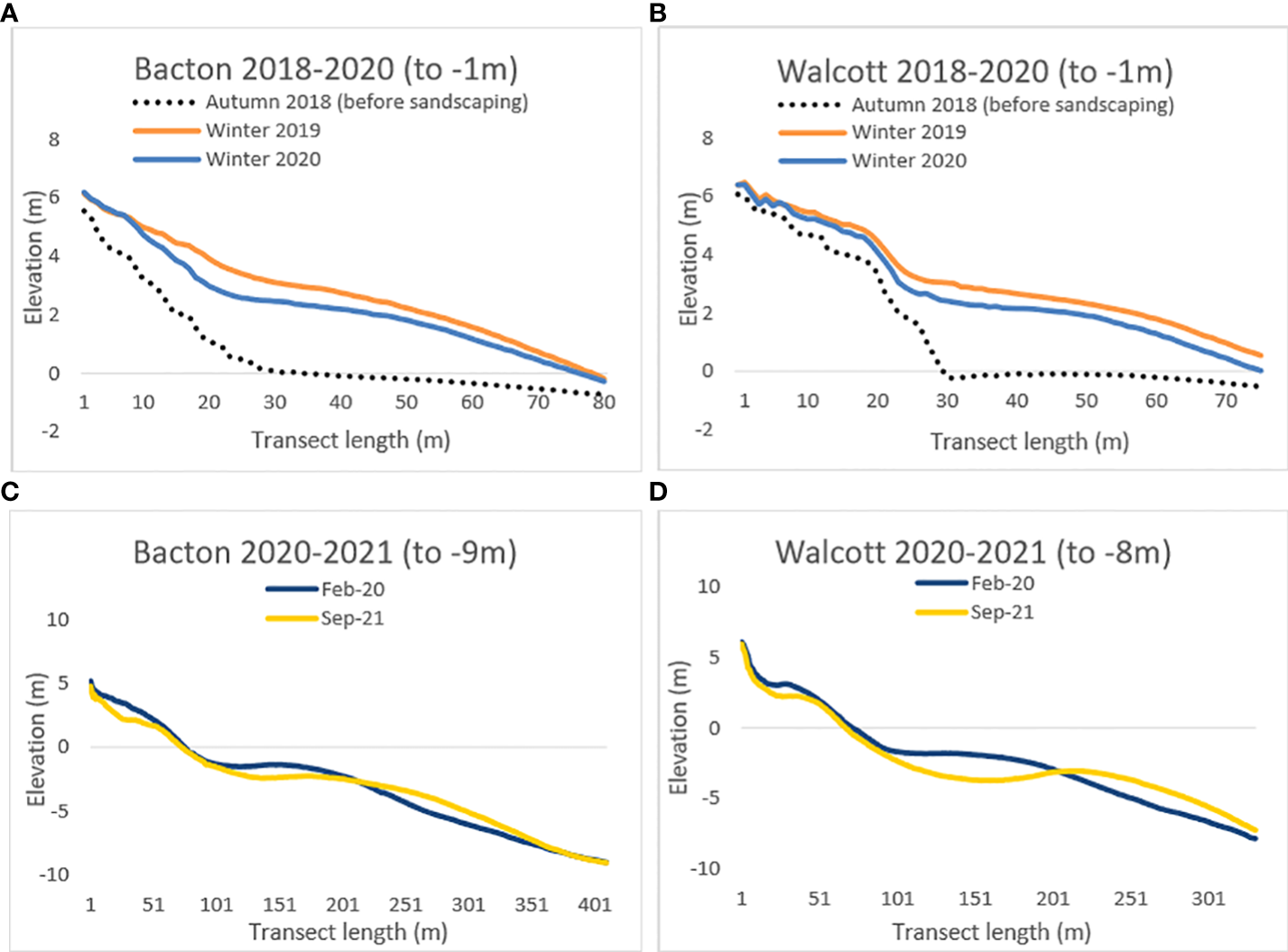
Beach profile elevation changes at Bacton (panel (A)) and Walcott (panel (B)) from 2018-2020, comparing changes on the upper shore and foreshore (to a depth of approximately -1m) before (dotted black line) and after sandscaping (year 1 in orange, year 2 in blue). Panel (C) and panel (D) reveal beach profile elevation changes at Bacton (panel (C)) and Walcott (panel (D)) for the timeseries 2020-2021, which corresponds to the two years after implementation of the scheme. Panel (C) and panel (D) sample to a depth of approximately -9m, revealing changes in the sub-tidal zone. Transects begin at the sea wall at Bacton and Walcott, and transect length increases seaward, as plotted on the x-axis. Panel (A) and panel (B) show secondary data from the Anglian Coastal Monitoring Programme (2022); panel (C) and panel (D) are secondary data from Royal Haskoning DHV (2022).
Overall, changes between 2020 and 2021 reveal a decrease in elevation/sediment in the upper subtidal zone just below the foreshore (approximately -1m to -4m elevation) occurring approximately 100m to 200m along the transect, and an increase in elevation/sediment between approximately 200m to 350m along the transect (Figure 2, panel C Bacton and panel D Walcott). Therefore, while Bacton and Walcott have seen a decrease in sediment on the upper shore and sub-tidally just below the foreshore, there was little change in elevation/sediment around the new location of the foreshore, and an increase in elevation/sediment in the lower sub-tidal zone in the first two years since sandscaping was implemented. The increased sediment in the lower sub-tidal zone may in part be migrated sediment from the upper ‘dry’ shore and/or upper subtidal. Both villages show a similar trend, although changes in sediment for the area sampled at Walcott (panel D) are larger than those at Bacton (panel C).
3.3 Impacts of the sandscaping scheme, and trust in coastal management
Analysis of survey questions on perceived impacts of sandscaping reveal that for many residents, sandscaping provides several positive impacts, beyond the principal positive impact of (thus far) no flooding or coastal erosion. Table 2 lists the types of different impacts reported by respondents, grouped into main themes. Impacts were not mutually exclusive; that is, respondents reported positive and/or negative impacts, or combinations of these; and some respondents reported no impacts.
Respondents spoke about the restorative benefits of having a superior sandy beach ‘coastscape’, and better beach access for recreational activities such as walking and swimming at all times of the day, rather than just at low tide. A few survey respondents conveyed enthusiasm that the coast is “back to its ‘old’ sandscape beach”, the village is “surviving” again, and the coast road remains open, strengthening sense of place of where they live. Respondents also reported psychological benefits (such as reduced anxiety) from the reduction in coastal flood or erosion risk, and financial benefits of no property damage from storms, higher house prices, and more visitors to the village (see Table 2).
Although reported impacts were largely positive, and 32% of respondents gave no negative impacts, the remaining respondents did report negative impacts. These included wind-blown sand, the impact of more visitors, and beach safety/access issues. For some wind-blown sand was an inconvenience (for example depositing around village, blowing through windows, requiring locks to be taped over), but for others it has led to damage and financial expense to clean up properties and gardens. This demonstrates how impacts have been experienced to differing extents. Some impacts, for example the impact of more visitors to an area, was reported positively by some (e.g., more trade, more popular village) but negatively by others (e.g., traffic, accessing beach). This indicates that the experience of impacts, and whether they are perceived as positive or negative, vary at an individual level.
Respondents were also asked about trust in local coastal management decision-making (n=73). Figure 3 shows a clear range of opinion amongst respondents on whether coastal change is managed appropriately for their village: 25% respondents either strongly or partially disagree with this statement (and of this, 14% strongly disagree with this statement), and 29% neither agree or disagree. Meanwhile, 47% of residents strongly or partially agree that they ‘trust that coastal change is managed appropriately in my village’.
Figure 3
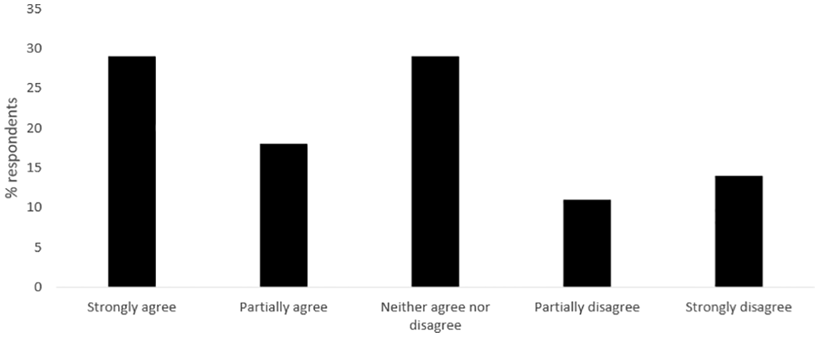
Respondent responses to survey question ‘I trust that coastal change is managed appropriately in my village’ (n=73).
4 Discussion
4.1 Perceived effectiveness of the sandscaping scheme
Different views of effectiveness are apparent amongst Bacton and Walcott residents in relation to the sandscaping scheme: reflecting on the first two years of the scheme, some perceive it to be working (largely due to no flooding or erosion) and some do not (due to a decrease in placed sediment on the beaches). Diverging views amongst local stakeholders and concerns over effectiveness have been found elsewhere in other coastal contexts, e.g., smaller-scale beach nourishment (Prati et al., 2016) and of managed realignment (Roca and Villares, 2012). The contrasting perceptions at Bacton and Walcott indicate different understandings amongst residents on how sandscaping is expected to evolve and change the local coastline over time. The LiDAR (elevation) data of the coast shows that although there has been a decrease of sediment on the upper (dry) beach in the first two years of the scheme (which residents similarly pointed out), sediment stayed the same on the foreshore (between high and low tide), then decreased in the first ~100m of the subtidal and then increased in the next ~150m of the subtidal, where it will still contribute to reducing erosion risk.
These geomorphological observations match the modelling of the scheme (NNDC, 2022) indicating that sand would decrease on the beaches over time, and that sand would migrate seaward after storm events. This suggests that sandscaping is working as expected in the first few years of its lifetime. Identifying the source and direction of movement of sediment cross-shore and alongshore (in other words, attributing beach profile changes to sandscaping), is very difficult given the limited LiDAR data on sandscaping, and is not possible without analysis of the sediment, which is beyond the scope of this study. For local residents, the profile changes reported here would be difficult to observe from land, given the foreshore zone is under the mean high-water mark (i.e. below high tide and only periodically observable) and the sub-tidal is covered by water and unobservable.
The survey revealed doubt among some respondents on the long-term effectiveness of sandscaping. Even residents who feel the scheme has been effective to protect from erosion and flooding in the first 2.5 years expressed some scepticism that it will continue to be effective in 20 years. Observations of a drop in sand volume on the upper (beach) appear to contribute to this perception. This raises a question on the respondents’ understanding about how sandscaping would change the local beach at Bacton and Walcott over time. As mentioned in section 2.1, the local council (NNDC) organised several community engagement events before and during the implementation of the scheme, which included a Local Liaison Group, community drop-in events, and public information boards at Bacton and Walcott beaches (NNDC, 2017), alongside reporting in the media (e.g. BBC, 2017). Despite this, the scale of doubt (almost 1 in 4 respondents) over the long-term effectiveness of sandscaping suggests that diversity of opinions may be influenced by several factors, as highlighted in literature. This includes different perceptions of nature-based solutions (Anderson and Renaud, 2021) and on the goal of adaptation (Dilling et al., 2019). Further, studies specifically in the context of coastal management have shown different risk perceptions (Prati et al., 2016; O’Donnell, 2019) and perceived responsibility (Clément et al., 2015) of coastal change amongst coastal populations. More broadly, there is also long-standing research on public scepticism of expert knowledge, both within and outside of environmental policy and issues (Sjöberg, 1999; Fairbrother, 2017). This illustrates a challenge for policy-makers in local stakeholder engagement where there are many diverse opinions relating to coastal management, and numerous potential factors contributing to held opinions. Presenting early data, and keeping local residents regularly updated with how beaches will change, could be one way for coastal managers to answer questions and engage residents on the changing profile of sandscaping, which is novel and will evolve over time. This could be further explored in future research, to consider how and why different aspects of information are trusted or not.
4.2 Trust in coastal management at Bacton and Walcott
The study findings also show a divergence in opinion amongst residents on the extent to which they trust how coastal change is managed in their village. A quarter of respondents stated that they felt some or strong distrust in how coastal change is managed for their village (with 29% stating neutral responses to the question of trust). Trust in coastal decision-making for at-risk or contested coastlines has long been highlighted in the literature as a key barrier to coastal governance in England (Milligan et al., 2009; O’Riordan et al., 2014; Schmidt et al., 2014; Anderson and Renaud, 2021). Although studies at a national level report that relations amongst actors in coastal management have generally improved over time and since the publication of the second iteration of SMPs in 2006 (Famuditi et al., 2018), findings here suggest that distrust in coastal management persists at Bacton and Walcott, for part of the coastal population at least.
Low trust in how coastal change is managed can have implications for future coastal decisions, potentially acting as a barrier to public engagement and to the participation in, and acceptance of, longer-term adaptation strategies (O’Riordan et al., 2014). Further, the challenge of creating meaningful and successful public participation in coastal management has also been highlighted (e.g. Few et al., 2007). For Bacton and Walcott residents, it is unknown what coastal management will happen after the lifetime of the sandscaping scheme. As a novel, untested, nature-based solution, the actual lifetime of the sandscaping scheme is uncertain, with its 15-20 year estimate only serving as a guide. Survey responses showed a range of resident perceptions on how long the scheme could last (from anywhere between a few years to 25 years), with no geomorphological evidence available yet to confirm this either way. Meanwhile, a 10-year evaluation of the first mega-nourishment scheme (the Zandmotor scheme in Holland), implemented in 2011, suggests it is likely to last longer than its official 20 year estimate, because the loss of sediment observed in the first decade of the scheme was lower than expected (Huisman et al., 2021).
This further highlights the uncertainty of the longevity of sandscaping as a coastal management strategy; this is likely to be unique to each coastal context and raises an important question for coastal managers on when and how to prepare for future coastal risk. As seen in this study, this is further complicated by varying expectations amongst residents across Bacton and Walcott of when sandscaping will end, and differing levels of trust in the coastal management process for their villages. The current flood and coastal erosion strategy for England (Environment Agency, 2020, p.49) calls for “local leadership and support from the local community” in building resilience to future coastal change, but an agreement on what this looks like in practice may be extremely difficult. The launch of the £36 million Coastal Transition Accelerator Programme by the Department for Environment Food and Rural Affairs (Defra, 2022) may be an opportunity to work through multiple perspectives and rethink how future options of coastal change can be considered and planned for by at-risk coastal communities, and where increasing trust in the coastal management process appears to still be a relevant objective.
4.3 Social impacts of sandscaping
Survey responses on the social impacts of sandscaping from residents highlight a wide range of both positive and negative impacts, in the first two years of its implementation. Sandscaping has provided multiple positive impacts to the local villages, but a uniquely positive experience has not been felt or reported by all. Across the survey, residents think differently about the scheme despite drawing upon the same observation or impact. For example, the contrast between survey respondents who felt sandscaping is not working because of the reduction in sand and those who felt it is working despite it, or respondents who felt sandscaping was positively impacting their village because of more tourists and those who perceived this as a negative impact. Longitudinal work, or more in-depth qualitative work, such as interviews or focus groups, could be conducted later in the lifetime of the sandscaping scheme, to compare how and why residents’ perceptions and experiences change over time. This could be analysed in conjunction with a study on mineralogy, to explore where placed sediment from the scheme has migrated along the coastline.
The role of an individual’s values in influencing different perceptions of beach nourishment has been found elsewhere (Prati et al., 2016), and the survey findings presented here suggest there may be deeply engrained beliefs, which alongside personal experience, shape an individual’s perception of a coastal management strategy and its effectiveness. The range of social impacts and experiences of sandscaping also seem to reflect the argument by de Schipper et al. (2021) that evaluations of beach nourishment’s overall ‘effectiveness’ needs to consider both social and physical impacts. In the context of mega-nourishment at Bacton and Walcott, the survey results suggest that the range of social impacts and perceptions on sandscaping have implications for building the social resilience of communities to coastal change after the lifetime of the scheme. This is in terms of potentially conflicting preferences for future coastal management, and which is an overlooked component of system resilience in the beach nourishment literature.
4.4 Perceptions/preferences of ‘soft’ versus ‘hard’ engineering
Over a quarter of surveyed Bacton and Walcott respondents perceived hard defences to be a more effective coastal management strategy to protect from flooding and erosion compared to sandscaping. Examples of hard defences mentioned in the survey are those historically used at this area of the coastline, or those used successfully elsewhere (such as rock barriers, reefs, breakwaters, and extending the existing sea wall). Numerous factors could be contributing to this perception, including that sandscaping is relatively novel and therefore seen as uncertain or ‘untested’, or that hard defences have for decades historically been used at the villages of Bacton and Walcott to manage the risk of coastal change. Sandscaping works very differently to hard defences, in that it is constantly changing, partially invisible or submerged by tides, and of a much larger spatial and temporal scale. The issue remains that if sandscaping is being compared ‘like-for-like’ to how hard defences are engineered, indeed this soft engineering approach could be perceived as less effective - for example sand will ‘wash away’ (as noted by residents in the survey) while hard defences stay put and thus may be perceived to better protect from coastal risk. This is despite evidence that hard defences can themselves exacerbate erosion, and by suppressing the movement of sediment, can exacerbate the risk of erosion elsewhere along the coast (AECOM, 2012: Nicholls et al., 2013).
Even residents who perceive sandscaping to be effective also suggest hard defences should be put in now to support sandscaping. Amidst the uncertainty on the perceived lifetime of sandscaping, this indicates that hard defences (either in combination or replacing sandscaping) are seen by some respondents as a more reliable coastal management strategy. It is therefore important that the advantages and disadvantages of nature-based solutions, or any novel strategy, particularly where implemented in places with historically very different management strategies, are included in communication to and discussions with key stakeholders, and for this engagement to be ongoing (Anderson and Renaud, 2021). For the case of the Bacton-Walcott sandscaping scheme, further exploration of the merit of different approaches to communicating nature-based solutions, from the perspective of key stakeholders would be an important next step.
5 Conclusions
In a coastal management policy context where strategies are becoming increasingly innovative or with multiple win-win objectives, there is a need to expand how we monitor and evaluate ‘effectiveness’ to encompass the broad range of physical, social, and other relevant objectives, in its unique context. Findings here of residents’ perceptions and geomorphological observations of the Bacton-Walcott sandscaping scheme indicate that considering nourishment strategies in terms of physical risk alone is not sufficient in measuring overall ‘effectiveness’. There are some differences between residents’ perceptions of the scheme and geomorphological change. As a case study rooted in the local context of Bacton and Walcott, further research could be conducted elsewhere to understand how perceived effectiveness of adaptation compares in different contexts, either where mega-nourishment is implemented or otherwise. This paper has found a range in residents’ perceptions of, and impacts from, the implementation of sandscaping, highlighting the need for further engagement with local stakeholders about how sandscaping is evolving on the coast. This could potentially be through citizen science that includes residents in ongoing monitoring and reporting change. The range and uncertainty in residents’ perceptions, alongside prevailing low trust amongst some in how coastal change is managed, highlight the challenge for coastal managers in planning for the future, and considering different perspectives in relation to future coastal management. There is a need to consider how residents may engage in varying ways, and how residents’ differing views may inform future coastal management. Facilitating this requires further attention, given the greater role envisaged by policymakers (for example the Environment Agency, 2020) on UK coastal communities contributing to coastal decisions made in their area.
Funding
This study is part of a publicly funded studentship, with joint funding from SeNSS-ARIES Doctoral Training Programmes (funded by the Economic and Social Research Council and the Natural Environment Research Council, respectively).
Acknowledgments
This paper uses secondary LiDAR data from the Anglian Coastal Monitoring Programme (freely accessible at https://coastalmonitoring.org/cco/). This paper also has permission to access secondary data from Royal HaskoningDHV ©. This is copyright material and may not be copied in whole or in part without the express written permission of Royal HaskoningDHV. The studentship is working in collaboration with, but independent of, North Norfolk District Council, who have provided local expertise throughout the project. The authors would like to thank the Bacton and Walcott residents who gave their time to contribute to this project by completing the study’s public survey.
Publisher’s note
All claims expressed in this article are solely those of the authors and do not necessarily represent those of their affiliated organizations, or those of the publisher, the editors and the reviewers. Any product that may be evaluated in this article, or claim that may be made by its manufacturer, is not guaranteed or endorsed by the publisher.
Statements
Data availability statement
The raw data supporting the conclusions of this article will be made available by the authors, without undue reservation.
Ethics statement
The studies involving human participants were reviewed and approved by DEV Ethics Research Committee (DEV S-REC) at the University of East Anglia (UEA). The patients/participants provided their written informed consent to participate in this study.
Author contributions
IC conducted the data collection and data analysis, with guidance from JF, IL, and TT. IC led the drafting of the manuscript, with guidance and written edits from JF, IL and TT. All authors contributed to the article and approved the submitted version.
Conflict of interest
The authors declare that the research was conducted in the absence of any commercial or financial relationships that could be construed as a potential conflict of interest.
Supplementary material
The Supplementary Material for this article can be found online at: https://www.frontiersin.org/articles/10.3389/fmars.2022.1028819/full#supplementary-material
References
1
Adger W. N. Arnell N. W. Tompkins E. L. (2015). Successful adaptation to climate change across scales. Global Environ. Change15 (2), 77–86. doi: 10.1016/j.gloenvcha.2004.12.005
2
AECOM (2012). Kelling to lowestoft ness shoreline management plan (Cheshire: AECOM).
3
Anderson C. C. Renaud F. G. (2021). A review of public acceptance of nature-based solutions: The ‘why’, ‘when’, and ‘how’ of success for disaster risk reduction measures. Ambio.50 (2021), 1552–1573. doi: 10.1007/s13280-021-01502-4
4
Anglian Coastal Monitoring Programme (ACMP) (2022) Anglian regional coastal monitoring programme. Available at: https://coastalmonitoring.org/anglian/ (Accessed August 8, 2022).
5
Ariza E. Lindeman K. C. Mozumder P. Suman D. O. (2014). Beach management in Florida: Assessing stakeholder perceptions on governance. Ocean Coast. Manage.96 (August 2014), 82–93. doi: 10.1016/j.ocecoaman.2014.04.033
6
BBC (2017) Bacton and Walcott sandscaping project key to protecting east coast. Available at: https://www.bbc.co.uk/news/av/uk-england-norfolk-49607888 (Accessed August 16 2022).
7
BGS (2021) Coastal erosion at happisburgh, Norfolk. Available at: https://www.bgs.ac.uk/case-studies/coastal-erosion-at-happisburgh-norfolk-landslide-case-study/ (Accessed December 17, 2021).
8
Bolle A. Baelus L. Kragiopoulou E. Van Quickelborne E. Lanckriet T. Institution for Civil Engineers (2020)Comparing hard and soft engineering solutions for Marina inlet sedimentation and coastal erosion at blankenberge and wenduine, Belgium. In: Coastal management 2019: Joining forces to shape our future coasts (Accessed June 7 2022).
9
Bontje L. E. Gomes S. L. Wang Z. Slinger J. H. (2019). A narrative perspective on institutional work in environmental governance – insights from a beach nourishment case study in Sweden. J. Environ. Plann. Manag.62 (1), 30–50. doi: 10.1080/09640568.2018.1459512
10
Brooks S. M. Spencer T. (2019). “Long-term trends, short-term shocks and cliff responses for areas of critical coastal infrastructure,” in Coastal sediments 2019: International conference on coastal sediments 2019. Eds. WangP.RosatiJ. D.ValleeM. (Tampa/St. Petersburg, Florida, USA: World Scientific), 1179–1187.
11
Buser M. (2020). Coastal adaptation planning in fairbourne, Wales: lessons for climate change adaptation. Plann. Pract. Res.35 (2), 127–147. doi: 10.1080/02697459.2019.1696145
12
Cabezas-Rabadán C. Rodilla M. Pardo-Pascual J. E. Herrera-Racionero P. (2019). Assessing users’ expectations and perceptions on different beach types and the need for diverse management frameworks along the Western Mediterranean. J. Land Use Policy81 (February 2019), 219–231. doi: 10.1016/j.landusepol.2018.10.027
13
Charmaz K. (2006). Constructing grounded theory (California: SAGE Publications Ltd).
14
Clément V. Rey-Vallette H. Rulleau B. (2015). Perceptions on equity and responsibility in coastal zone policies. Ecol. Econ.119 (November 2015), 284–291. doi: 10.1016/j.ecolecon.2015.09.005
15
Clipsham V. Flikweert J. Adnitt C. Doygun G. Spaan G. Fletcher A. et al . (2018)Sandscaping: Making innovative coastal management work in the UK. In: Coasts, marine structures and breakwaters 2017 (Accessed August 8, 2022).
16
Defra (2022) Communities to trial innovative ways of adapting to coastal erosion. Available at: https://www.gov.uk/government/news/communities-to-trial-innovative-ways-of-adapting-to-coastal-erosion (Accessed August 8 2022).
17
de Schipper M. A. de Vries S. Ruessink G. de Zeeuw R. C. Rutten J. van Gelder-Maas C. et al . (2016). Initial spreading of a mega feeder nourishment: Observations of the sand engine pilot project. Coast. Eng.111 (May 2016), 23–48. doi: 10.1016/j.coastaleng.2015.10.011
18
de Schipper M. A. Ludka B. C. Raubenheimer B. Luijendijk A. P. Schlacher T. A. (2021). Beach nourishment has complex implications for the future of sandy shores. Nat. Rev. Earth Environ.2, 70–84. doi: 10.1038/s43017-020-00109-9
19
Dilling L. Prakash A. Zommers Z. Ahmad F. Singh N. de Wit S. et al . (2019). Is adaptation success a flawed concept? Nat. Climate Change9 (2019), 572–574. doi: 10.1038/s41558-019-0539-0
20
Doswald N. Munroe R. Roe D. Giuliani A. Castelli I. Stephens J. et al . (2014). Effectiveness of ecosystem-based approaches for adaptation: review of the evidence-base. Climate Dev.6 (2), 185–201. doi: 10.1080/17565529.2013.867247
21
Environment Agency (2011) Coastal flood boundary conditions for the mainland UK coasts and islands. Available at: https://www.gov.uk/flood-and-coastal-erosion-risk-management-research-reports/coastal-flood-boundary-conditions-for-the-mainland-uk-coasts-and-islands (Accessed August 16 2022).
22
Environment Agency (2020) Flood and coastal erosion risk management strategy roadmap to 2026. Available at: https://www.gov.uk/government/publications/flood-and-coastal-erosion-risk-management-strategy-roadmap-to-2026 (Accessed July 11 2022).
23
Fairbrother M. (2017). Environmental attitudes and the politics of distrust. Sociol. Compass11 (5). doi: 10.1111/soc4.12482
24
Famuditi T. Bray M. Potts J. Baily B. Inkpen R. (2018). Adaptive management and community reaction: The activities of coastal action groups (CAGs) within the shoreline management process in England. Mar. Policy97 (November 2018), 270–277. doi: 10.1016/j.marpol.2018.06.025
25
Few R. Brown K. Tompkins E. L. (2007). Public participation and climate change adaptation: avoiding the illusion of inclusion. Climate Policy7 (1), 46–59. doi: 10.1080/14693062.2007.9685637
26
French P. W. (2004). The changing nature of, and approaches to, UK coastal management at the start of the twenty-first century. Geogr. J.170 (2), 116–125. doi: 10.1111/j.0016-7398.2004.00113.x
27
Glaser B. Strauss A. (1967). The discovery of grounded theory: Strategies for qualitative research (California: Sociology Press).
28
Gray J. O’Neill K. Qiu Z. (2017). Coastal residents' perceptions of the function of and relationship between engineered and natural infrastructure for coastal hazard mitigation. Ocean Coast. Manag.146 (September 2017), 144–156. doi: 10.1016/j.ocecoaman.2017.07.005
29
Hoonhout B. de Vries S. (2017). Field measurements on spatial variations in aeolian sediment availability at the sand motor mega nourishment. Aeolian Res.24 (February 2017), 93–104. doi: 10.1016/j.aeolia.2016.12.003
30
Huisman B. J. Wijsman J. W. Arens S. M. Vertegaal C. T. van der Valik L. Van Donk S. C. et al . (2021) 10-years evaluation of the sand motor: Results of the monitoring- and evaluation program (MEP) for the period 2011 to 2021. Available at: https://dezandmotor.nl/en/research/ (Accessed August 8, 2022).
31
IPCC (2022). “Climate change 2022: Impacts, adaptation and vulnerability,” in Contribution of working group II to the sixth assessment report of the intergovernmental panel on climate change. Eds. Pörtner.H.-O.Roberts.D. C.Tignor.M.Poloczanska.E. S.Mintenbeck.K.Alegría.A.CraigM.LangsdorfS.LöschkeS.MöllerV.OkemA.RamaB. (Cambridge and New York: Cambridge University Press). doi: 10.1017/9781009325844
32
Jacobs (2019) Shoreline management plan refresh. SMP forum pre-meeting briefing. Available at: https://southerncoastalgroup-scopac.org.uk/ (Accessed February 3 2021).
33
Johnson M. Goodliffe R. Doygun G. Flikweert J. Institution for Civil Engineers (2020)The UK’s first sandscaping project (Bacton, Norfolk) from idea to reality. In: Coastal management 2019: Joining forces to shape our future coasts (Accessed August 8 2022).
34
Lozoya J. P. Sardá R. Jiménez J. A. (2014). Users expectations and the need for differential beach management frameworks along the Costa brava: Urban vs. natural protected beaches. Land Use Policy38 (May 2014), 397–414. doi: 10.1016/j.landusepol.2013.12.001
35
Luijendijk A. P. Ranasinghe R. de Schipper M. A. Huisman B. A. Swinkels C. M. Walstra D. J. et al . (2017). The initial morphological response of the sand engine: A process-based modelling study. Coast. Eng.119 (January 2017), 1–14. doi: 10.1016/j.coastaleng.2016.09.005
36
Marin V. Palmisani F. Ivaldi R. Dursi R. Fabiana M. (2009). Users’ perception analysis for sustainable beach management in Italy. Ocean Coast. Manag.52 (5), 268–277. doi: 10.1016/j.ocecoaman.2009.02.001
37
Martell R. Mendoza E. Mariño-Tapia I. Odériz I. Silva R. (2020). How effective were the beach nourishments at cancun? J. Mar. Sci. Eng.8 (2020), 388. doi: 10.3390/jmse8060388
38
McKinley E. Pages J. F. Ballinger R. C. Beaumont N. (2020). Forgotten landscapes: Public attitudes and perceptions of coastal saltmarshes. Ocean Coast. Manag.187 (1 April 2020). doi: 10.1016/j.ocecoaman.2020.105117
39
MHCLG (2020) Land use statistics England 2018. Available at: https://www.gov.uk/government/statistics/land-use-in-england-2018.
40
Milligan J. O'Riordan T. Nicholson-Cole S. Watkinson A. (2009). Nature conservation for future sustainable shorelines: Lessons from seeking to involve the public. Land Use Policy26 (2), 203–213. doi: 10.1016/j.landusepol.2008.01.004
41
Moller I. Kudella M. Rupprecht F. Spencer T. Paul M. van Wesenbeeck B. K. et al . (2014). Wave attenuation over coastal salt marshes under storm surge conditions. Nat. Geosci.7, 727–731. doi: 10.1038/ngeo2251
42
Mott MacDonald (2016). Bacton to Walcott Sea flooding study (Norfolk: North Norfolk District Council).
43
Nature-Based Solutions Initiative (2022) Nature-based solutions to climate change. Available at: https://nbsguidelines.info/ (Accessed August 10 2022).
44
Nicholls R. J. Townend I. H. Bradbury A. P. Ramsbottom D. Day S. A. (2013). Planning for long-term coastal change: Experiences from England and Wales. Ocean Eng.71 (October), 3–16. doi: 10.1016/j.oceaneng.2013.01.025
45
Nicholson-Cole S. O’Riordan T. (2009). “Adaptive governance for a changing coastline: science, policy and publics in search of a sustainable future,” in Adapting to climate change (Thresholds, values, governance). Eds. AdgerW. N.LorenzoniI.O’BrienK. (Cambridge: Cambridge University Press), 368–383.
46
NNDC (2017) Bacton to Walcott coastal management summary report (and appendices). Available at: https://www.north-norfolk.gov.uk/media/3694/bacton-to-walcott-coastal-management-scheme-summary-report-inc-appendices.pdf (Accessed August 9 2022).
47
NNDC (2022) Bacton to Walcott coastal management. Available at: https://www.north-norfolk.gov.uk/sandscaping (Accessed August 8 2022).
48
North Norfolk District Council (NNDC) (2021) The possible impacts of second and holiday homes in north Norfolk. Available at: https://www.north-norfolk.gov.uk/news/2022/july/the-possible-impacts-of-second-and-holiday-homes-in-north-norfolk (Accessed August 8 2022).
49
O’Donnell T. (2019). Don’t get too attached: Property-place relations on contested coastlines. Trans. Inst. Br. Geogr.45 (3), 559–574. doi: 10.1111/tran.12368
50
ONS (2011) 2011 census. Available at: https://www.ons.gov.uk/census/2011census/2011censusdata/2011censusdatacatalogue.
51
O’Riordan T. Gomes C. Schmidt L. (2014). The difficulties of designing future coastlines in the face of climate change. Landscape Res.39 (6), 613–630. doi: 10.1080/01426397.2014.975108
52
Owen G. (2020). What makes climate change adaptation effective? a systematic review of the literature. Global Environ. Change62 (2020). doi: 10.1016/j.gloenvcha.2020.102071
53
POST (2021) Coastal management no 647. Available at: https://post.parliament.uk/research-briefings/post-pn-0647/ (Accessed August 8 2022).
54
Prati G. Albanesi C. Pietrantoni L. Airoldi L. (2016). Public perceptions of beach nourishment and conflict management strategies: A case study of portonovo bay in the Adriatic Italian coast. Land Use Policy50 (January 2016), 422–428. doi: 10.1016/j.landusepol.2015.06.033
55
QSR (2022) NVivo qualitative data analysis software. Available at: https://www.qsrinternational.com/nvivo-qualitative-data-analysis-software/home (Accessed August 26 2022).
56
Radermacher M. (2018) Impact of sand nourishments on hydrodynamics and swimmer safety (The Netherlands: Delft University of Technology) (Accessed August 8 2022).
57
Roca E. Villares M. (2012). Public perceptions of managed realignment strategies: The case study of the ebro delta in the Mediterranean basin. Ocean Coast. Manage.60 (May 2012), 38–47. doi: 10.1016/j.ocecoaman.2012.01.002
58
Roest B. de Vries S. de Schipper M. Aarninkhof S. (2021). Observed changes of a mega feeder nourishment in a coastal cell: Five years of sand engine morphodynamics. J. Mar. Sci. Eng.9 (1). doi: 10.3390/jmse9010037
59
Royal Haskoning DHV (2018). Bacton gas terminal coastal defence scheme: Scoping report (Peterborough: Haskoning DHV UK LTD).
60
Royal Haskoning DHV (2022) Royal haskoning DHV. Available at: https://global.royalhaskoningdhv.com/ (Accessed August 8 2022).
61
RSPB (2018) UK's largest ever coastal wetland restoration project nears completion. Available at: https://www.rspb.org.uk/about-the-rspb/about-us/media-centre/press-releases/wallasea-island-wild-coast-project-nears-completion/ (Accessed August 8 2022).
62
Rumson A. G. Hallett S. H. Brewer T. R. (2019). The application of data innovations to geomorphological impact analyses in coastal areas: An East Anglia, UK, case study. Ocean Coast. Manag.181 (November 2019). doi: 10.1016/j.ocecoaman.2019.104875
63
Schernewski G. Schumacher J. Weisner E. Donges L. (2018). A combined coastal protection, realignment and wetland restoration scheme in the southern Baltic: planning process, public information and participation. J. Coast. Conserv.22, 533–547. doi: 10.1007/s11852-017-0542-4
64
Schmidt L. Gomes C. Guerreiro S. O’Riordan T. (2014). Are we all on the same boat? the challenge of adaptation facing Portuguese coastal communities: Risk perception, trust-building and genuine participation. Land Use Policy38 (May 2014), 355–365. doi: 10.1016/j.landusepol.2013.11.008
65
Shell (2021) About bacton gas plant. Available at: https://www.shell.co.uk/about-us/projects-and-sites/bacton-gas-plant/about-bacton-gas-plant.html (Accessed August 8 2022).
66
Singh C. Iyer S. New M. G. Few R. Kuchimanchi M. Segnon A. C. et al . (2021). Interrogating ‘effectiveness’ in climate change adaptation: 11 guiding principles for adaptation research and practice. Climate Dev14 (7), 650–664. doi: 10.1080/17565529.2021.1964937
67
Sjöberg L. (1999). Risk perception by the public and by experts: A dilemma in risk management. Hum Ecol. Rev.6 (2), 1–9. doi: 10.1027/1016-9040.3.1.1
68
Stive M. de Schipper M. Luijendijk A. Aarninkhof S. van Gelder-Maas C. van Thiel de Vries J. et al . (2013). A new alternative to saving our beaches from sea-level rise: The sand engine. J. Coast. Res.29 (5), 1001–1008. doi: 10.2112/JCOASTRES-D-13-00070.1
69
Todd D. J. Bowa K. (2016). Development of beach health index for the gold coast, Australia. J. Coast. Res.75, 710–714. doi: 10.2112/SI75-142.1
70
United Nations (2015) The Paris agreement. Available at: https://unfccc.int/process-and-meetings/the-paris-agreement/the-paris-agreement (Accessed August 8 2022).
71
Usher L. E. (2021). Virginia And north Carolina surfers’ perceptions of beach nourishment. Ocean Coast. Manag.203. doi: 10.1016/j.ocecoaman.2020.105471
72
Vikolainen V. Filkweert J. Bressers H. Lulofs K. (2017). Governance context for coastal innovations in England: The case of sandscaping in north Norfolk. Ocean Coast. Manage.145 (August 2017), 82–93. doi: 10.1016/j.ocecoaman.2017.05.012
Summary
Keywords
adaptation, effectiveness, perceptions, sandscaping, coasts, nature-based solutions, coastal erosion, coastal management
Citation
Cotton I, Forster J, Lorenzoni I and Tolhurst TJ (2022) Understanding perceived effectiveness of a novel coastal management project: The case of the Bacton-Walcott sandscaping scheme, UK. Front. Mar. Sci. 9:1028819. doi: 10.3389/fmars.2022.1028819
Received
26 August 2022
Accepted
10 October 2022
Published
26 October 2022
Volume
9 - 2022
Edited by
Ali Mohammad Rezaie, University of Asia Pacific, Bangladesh
Reviewed by
Lucy Bricheno, University of Southampton, United Kingdom; Kate Mulvaney, United States Environmental Protection Agency, United States
Updates
Copyright
© 2022 Cotton, Forster, Lorenzoni and Tolhurst.
This is an open-access article distributed under the terms of the Creative Commons Attribution License (CC BY). The use, distribution or reproduction in other forums is permitted, provided the original author(s) and the copyright owner(s) are credited and that the original publication in this journal is cited, in accordance with accepted academic practice. No use, distribution or reproduction is permitted which does not comply with these terms.
*Correspondence: Isabel Cotton, i.cotton@uea.ac.uk
This article was submitted to Coastal Ocean Processes, a section of the journal Frontiers in Marine Science
Disclaimer
All claims expressed in this article are solely those of the authors and do not necessarily represent those of their affiliated organizations, or those of the publisher, the editors and the reviewers. Any product that may be evaluated in this article or claim that may be made by its manufacturer is not guaranteed or endorsed by the publisher.