 Zili Zhang
 Jinsong Liu1
- 1Zhejiang Province Ecological Environment Monitoring Centre, Hangzhou, China
- 2Sun Yat-sen University, Guangzhou, China
1 Introduction
Rivers and lakes serve as critically important water bodies on Earth’s surface. Currently, freshwater algal blooms have become a global ecological phenomenon, occurring in diverse water bodies such as lakes, rivers, and reservoirs across temperate and tropical regions, and have increased significantly over the past several decades. Since the 1980s, around 68% of the world’s lakes have undergone a persistent rise in algal bloom intensity (Ho et al., 2019; Sukharevich and Polyak, 2020). The degradation of water quality and eutrophication in global freshwater systems have emerged as significant environmental challenges, predominantly driven by anthropogenic activities and accelerating climate change (Suresh et al., 2023; Van Vliet et al., 2023; Liu et al., 2020; Wang et al., 2020). The occurrence of algal blooms in inland waters poses a serious threat to aquatic ecosystems and public health and safety (Brooks et al., 2016). Waters affected by algal blooms often exhibit high levels of eutrophication, and the subsequent death of blooms can deplete dissolved oxygen, resulting in black bloom events. Beyond degrading water aesthetics and severely damaging aquatic ecosystems, algal blooms also pose health risks to humans and animals through their associated toxins.
Remote sensing demonstrates distinct advantages in aquatic environmental monitoring through its comprehensive spatial information acquisition, operational efficiency, and cost-effectiveness. It enables the timely detection of marine environmental risks such as algal blooms and oil spills, and supports the rapid identification of water quality anomalies in coastal bays and estuarine rivers, as well as pollution source tracking. These capabilities have established novel research pathways for forecasting river-to-ocean pollution events through enhanced spatiotemporal monitoring frameworks. For example, Chen et al. (2023) used 30 years (1990–2019) of data to analyze the spatial and temporal characteristics of the Harmful algal blooms (HABs) along the Chinese coasts. To assess the feasibility of remote sensing for detecting HABs in small to medium-sized waterbodies, Liu et al. (2022) applied data from three satellites—Planetscope, Sentinel-2 and Landsat-8—to analyze the impacts of spatial resolution, spectral band availability, and waterbody size on detection accuracy. Similarly, Binding et al. (2018) investigated algal bloom dynamics in Lake Winnipeg using satellite-derived chlorophyll-a (Chl-a) and metrics of bloom intensity, spatial extent, severity, and duration over the MERIS mission period. Current remote sensing monitoring of algal blooms, however, predominantly targets large water bodies (e.g., oceans, lakes, and reservoirs), while riverine algal blooms have received disproportionately less attention. This disparity is primarily attributed to the lower bloom frequency in river systems compared to lentic ecosystems, coupled with the heightened requirements for retrieval accuracy and stability imposed by complex river hydrodynamics (Rolim et al., 2023).
Algal bloom retrieval models with remote sensing are primarily classified into three categories: empirical, semi-empirical, and physical models (Li et al., 2025; Yang et al., 2025; Vasilakos et al., 2020; Lu et al., 2020; Chen et al., 2022; Yang et al., 2022; Chang et al., 2015). Empirical and semi-empirical models primarily rely on statistical analysis to establish relationships between remote sensing signals and Chl-a concentrations through extensive field-measured datasets (EI-Rawy et al., 2020; Yang et al., 2023; Xiao et al., 2022). These models demonstrate operational simplicity and computational efficiency, but exhibit limited generalizability beyond specific study areas. In contrast, physical models are grounded in rigorous radiative transfer theory, which quantitatively describes the relationship between aquatic components and satellite-derived irradiance through specific absorption coefficients and scattering coefficients of water constituents (Li et al., 2025; Guo et al., 2022). These models simulate light propagation processes in both atmospheric and aquatic environments using radiative transfer equations, enabling quantitative inversion of water quality parameter from remote sensing data. In recent years, the rapid advancement of artificial intelligence (AI) has facilitated the successful application of machine learning algorithms, particularly Artificial Neural Networks (ANNs), Support Vector Machines (SVMs), and Random Forest (RF), in remote sensing-based monitoring of organic pollutants in aquatic environments (Vinothkumar and Karunamurthy, 2023; Zhang et al., 2022; Ruescas et al., 2018; Deng et al., 2019). Furthermore, emerging deep learning architectures have demonstrated enhanced capabilities in water color remote sensing for retrieving concentrations of critical water quality parameters (Arshad et al., 2024, 2023; Khan et al., 2023; Ullah et al., 2024). The integrated application of multi-model approaches enables complementary advantages among different methodologies, significantly enhancing the accuracy and stability of water environment remote sensing monitoring.
This study proposes an integrated approach combining satellite remote sensing with in situ measurements to establish a multi-technique collaborative monitoring framework for algal blooms in sea-reaching rivers. The framework addresses the challenges of cross-system ecological transitions and salinity gradients in river-to-sea transitional zones. A seasonal algal bloom event in the Qiantang River Basin from July to September 2016 was documented, with its complete phenological cycle (initiation, evolution, and senescence) through multi-temporal remote sensing data at a 30m resolution. The results demonstrate that the Chl-a remote sensing physical mechanism model offers advantages of robust adaptability and algorithm stability, enabling large-scale synchronous monitoring of river algal blooms. Furthermore, the integration of extensive synchronous remote sensing observations with conventional in situ point monitoring significantly enhances the spatiotemporal resolution and efficiency of river bloom surveillance.
2 Study area
The Qiantang River Basin is situated between latitude 28°N and 30.5°N and longitude 117.5°E and 120.5°E. Its main stream spans 668 kilometers, encompassing tributaries such as the Xin’an River and Fuchun River, with an average annual runoff of 43.458 m3 and a drainage area of approximately 60,000 km2 (Sun et al., 2016). The construction of multistage hydrojunction projects along the mainstem and tributaries of the Qiantang River has induced flow attenuation in certain reaches. Compounded by rapid regional socioeconomic development in recent decades, this anthropogenic modification of hydrological regimes has facilitated the persistent accumulation of nutrients (e.g., nitrogen and phosphorus) within aquatic systems. Such conditions create a critical threshold whereby algal blooms can be rapidly triggered when meteorological and hydrological parameters reach conducive levels. Seasonal algal blooms in the Qiantang River Basin were initially documented as early as the late 20th century, with particularly extensive outbreaks occurring in 2004 and 2010 that triggered severe deterioration of water quality across the watershed (Gao et al., 2025; Reinl et al., 2020; Zhou et al., 2022).
3 Data and methods
3.1 Satellite data sources and ground-based observational data
The HJ-1A/B satellites, China’s first domestically developed civilian satellites dedicated to environmental monitoring and disaster mitigation/emergency response, were launched on September 6, 2008. The HJ-1A/B satellites were each equipped with two wide-coverage multispectral CCD cameras, covering four broad spectral bands in the visible and infrared ranges. When operated jointly, these dual-camera systems achieve a 4-day revisit cycle, enabling push-broom imaging with a swath width of 720 km, a spatial resolution of 30 m, and four spectral bands. The HJ-1A/B satellites adopt a band configuration modeled after the U.S. Landsat series, featuring medium spatial resolution and broad spectral coverage, while achieving a wider swath width and shorter revisit cycle compared to their counterparts. One single image of the HJ-1A/B satellites can achieve complete coverage of the Qiantang River Basin, fulfilling the temporal resolution requirements of the study. The key parameters of the HJ-1A/B satellites’ CCD sensors are presented in Table 1.
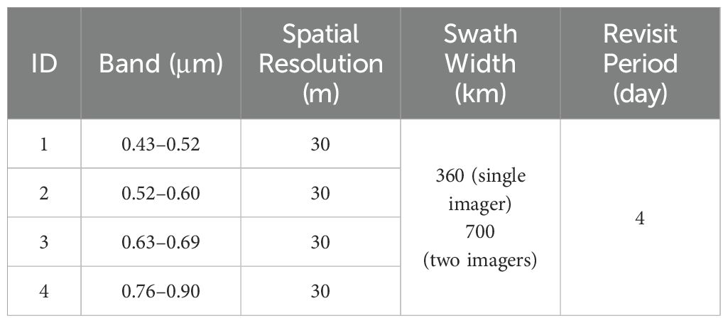
Table 1. The CCD data parameters of HJ-1A/B satellites.
Satellite imagery acquired over the Qiantang River system from July to September 2016 was screened according to the cloud cover threshold of<20%, with the final selected images presented in Table 2.
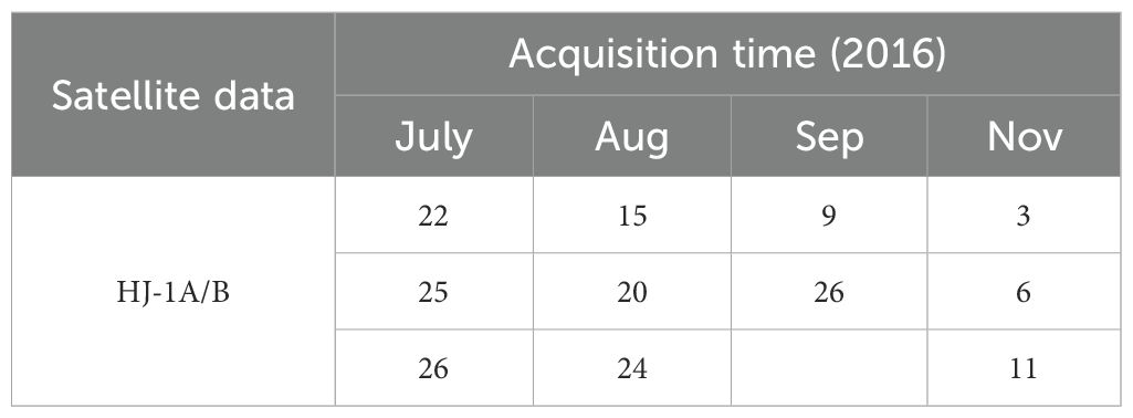
Table 2. Satellite data employed in this study.
In addition, synchronized field investigations of algal blooms and emergency water quality monitoring were conducted from July to August 2016. Ground-based investigations employed a dual-mode approach: (1) Fixed-point instrumentation for regular monitoring of water quality parameters and algal bloom occurrence; (2) Event-driven manual sampling with laboratory quantification during bloom episodes in affected areas. Field sampling and analysis were conducted in strict compliance with applicable water quality monitoring standards. The spatial distribution of in situ fixed sampling locations is illustrated in Figure 1. The monitored parameters included conventional physicochemical indicators as well as biological indicators such as Chl-a, algal density, and algal species composition and so on.
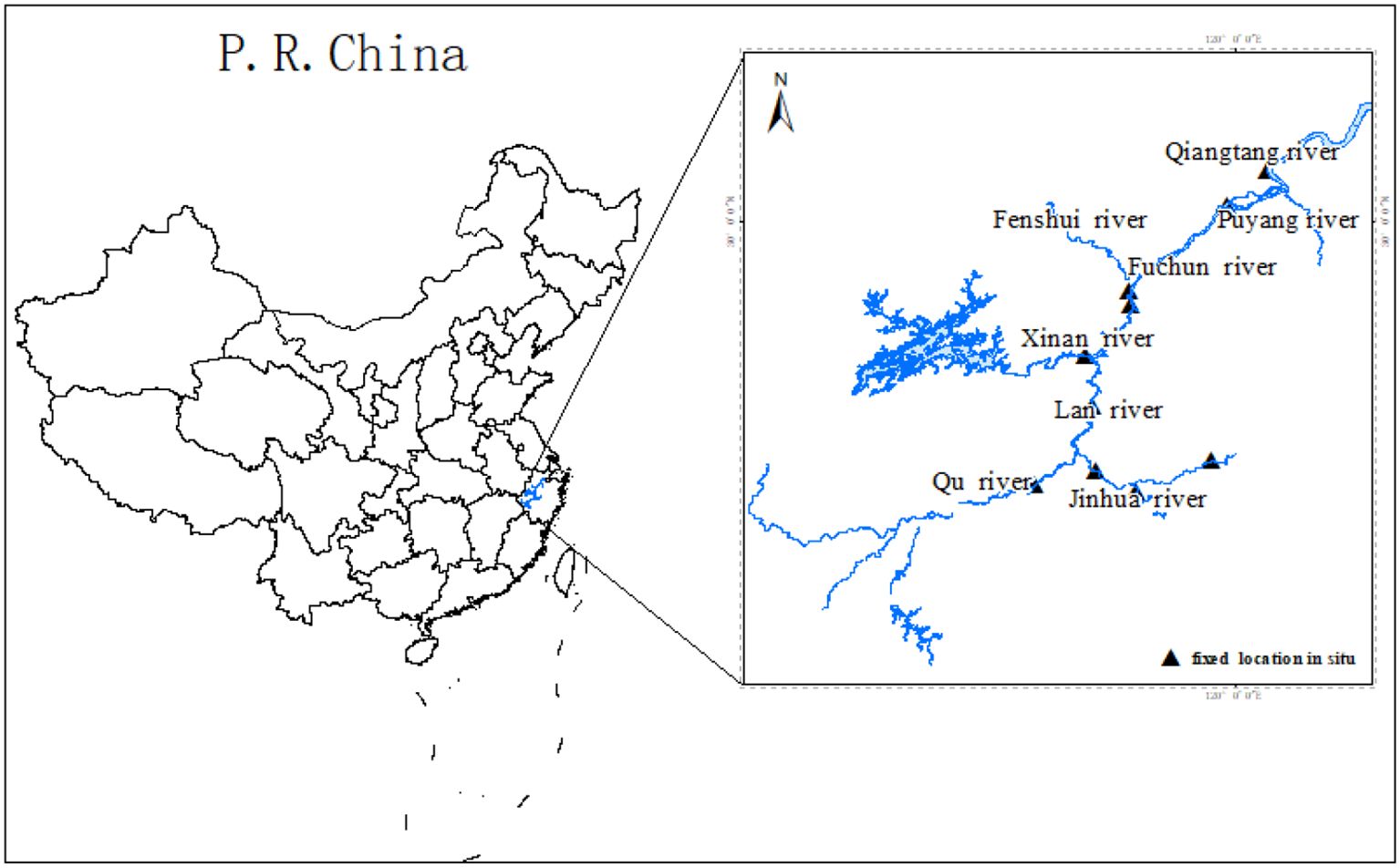
Figure 1. Schematic diagram of river reach distribution in the Qiantang River.
3.2 Development of remote sensing retrieval model for algal blooms
The water-leaving radiance captured by satellite remote sensing sensors results from the combined effects of: (1) air-water interface reflectance and refraction, (2) water column absorption and scattering processes, and (3) benthic substrate absorption and reflectance. The spectral characteristics of water bodies are predominantly characterized by volume scattering, resulting from the combined effects of water molecules and suspended impurities within the water. The primary pollutants in the water body are suspended sediments, oxygen-consuming organic matter, and Chl-a. The inherent optical parameters (IOPs), such as absorption and scattering coefficients, exhibit wavelength-independent characteristics across the light spectrum.
The radiative transfer process in water bodies can be expressed as follows (Li et al., 2022; Lu et al., 2020): The water-leaving radiance (Lw) is composed of upwelling scattered radiance from the entire water column (Ls) and the bottom substrate-reflected radiance (Lb), as mathematically represented by Equation 1:
Based on the radiative scattering characteristics and radiative transfer processes in aquatic environments, the determination of the total radiative transfer model for water bodies requires two essential components: 1) solution of upwelling scattering throughout the entire water column, and 2) calculation of substrate reflectance at the water bottom.
For upwelling scattering, the incident light intensity differs across varying water depths. When considering the scattering contribution from a thin water layer of thickness dh at depth h (Equation 2).
E is the downwelling irradiance at water depth h, which can be expressed as by Equation 3
In the equation, denotes the total absorption coefficient of the water body, while . represents the total scattering coefficient (Equations 4, 5).
The symbols w, s, u and v represent pure water, suspended sediment, oxygen-consuming organic matter, and Chl-a, respectively, while d denotes the unknown concentrations of each constituent to be solved.
The incident light is first attenuated by the thin water layer. The upward scattered light then undergoes secondary attenuation through the upper water layer before emerging from the water surface. The expression is given as follows by Equation 6:
The upwelling scattered radiance Ls of the entire water column can be derived by integrating Equation 6, as represented by Equation 7.
Then , the extinction coefficient .
Assuming the water bottom substrate is a Lambertian surface, the radiance exiting the water body is represented by Equation 8.
The conversion from radiance to surface reflectance (Rw) is expressed as Equation 9:
Substituting (7) and (8) into (1) and transforming to reflectance via (9) yields the general radiative transfer equation for water bodies represented by Equation 10.
The scattering and absorption coefficients of suspended sediment, colored dissolved organic matter (CDOM), and Chl-a can be experimentally determined. The unknowns to be resolved by the model include Ds, Dv, Du and water depth H and benthic substrate reflectance Rb (Equations 4, 5).
For the underdetermined system of equations where the number of unknowns exceeds the number of spectral bands, the Chl-a concentration in water bodies can be solved by analyzing the optical properties of the study area and selecting sensitive bands to construct the equations (Li et al., 2025; Yang et al., 2025; Liang et al., 2024). In this study, since HJ-1A/B employed consist of four spectral bands, the Chl-a concentration in water bodies was derived by solving a system of four simultaneous equations.
After a series of data processing steps, including geometric correction, radiometric calibration, radiometric correction, atmospheric correction, land-water separation, and remote sensing inversion of water quality parameters—followed by calibration using sampled laboratory measurements—the remote sensing monitoring results of Chl-a concentration and algal bloom status in the Qiantang river were finally obtained.
3.3 Geometric correction and radiometric calibration
Radiometric calibration is the process of converting the digital number (DN) values in raw imagery into radiance using calibration parameters provided in satellite data files. Radiometric correction is performed to derive planetary reflectance for all bands at each pixel from radiance using solar spectral irradiance per band, with corrections applied for solar incidence angle and viewing geometry effects.
3.4 Atmospheric correction and land-water separation
Atmospheric correction aims to remove/minimize the influence of atmospheric scattering and absorption in remote sensing data. Atmospheric correction analyzes atmospheric factors, constructs and solves models to maximally mitigate atmospheric interference. The dark target method was employed to derive the relevant atmospheric parameters in this study. To mitigate water vapor effects, clear/deep water pixels were employed as dark targets. After measuring the reflectance of clear water, the atmospheric optical thickness and transmittance were calculated to achieve atmospheric correction.
Following atmospheric correction, water-land separation was performed using a simple threshold approach with the modified Normalized Difference Water Index (NDWI) (Liang et al., 2023; Rad et al., 2021; Mcfeeters, 1996).
3.5 Retrieval of chlorophyll-a concentration in surface water
Given that phytoplankton predominantly accumulate at the air-water interface during extensive bloom events, the sensor-reaching radiance in red and near-infrared bands is mainly representative of surface water characteristics. The reflectance and absorption characteristics of Chl-a lead to a significant enhancement of spectral features in both the red and near-infrared bands, thereby providing more favorable conditions for the retrieval of Chl-a concentration. The study adopts the Chl-a water quality remote sensing physical model described in Section 2 to retrieve water Chl-a concentration through simultaneous inversion using both red and shortwave near-infrared band data (Equations 4, 5). Since the penetration depth of shortwave near-infrared radiation is approximately 25 cm, the retrieved Chl-a concentration primarily represents the surface water Chl-a level, with minimal influence from bottom reflectance.
3.6 Remote sensing index-based classification of algal blooms
Chl-a concentration thresholds serve as critical indicators for classifying algal bloom severity in aquatic ecosystem monitoring standards. Adhering to established in situ monitoring protocols and accounting for regional hydrological characteristics, this study implemented the following threshold-based classification: a mild algal bloom corresponds to Chl-a concentrations of 15–25 μg/L, a moderate algal bloom to 25–50 μg/L, and a severe algal bloom to concentrations exceeding 50 μg/L.
4 Results and discussion
4.1 Validation of accuracy
To validate the accuracy of remote sensing inversion for Chl-a concentration in water bodies, ground-based synchronous observations were collected, yielding a total of 49 paired synchronous ground observation points during satellite overpasses. Figure 2 shows a comparison between the remote sensing inversion results of the algal bloom index and the in situ measured Chl-a concentrations on August 15 and August 20, 2016, during the algal bloom event in the Qiantang River. Figure 3 shows the accuracy comparison between the remote sensing inversion results of Chl-a and the measured values.
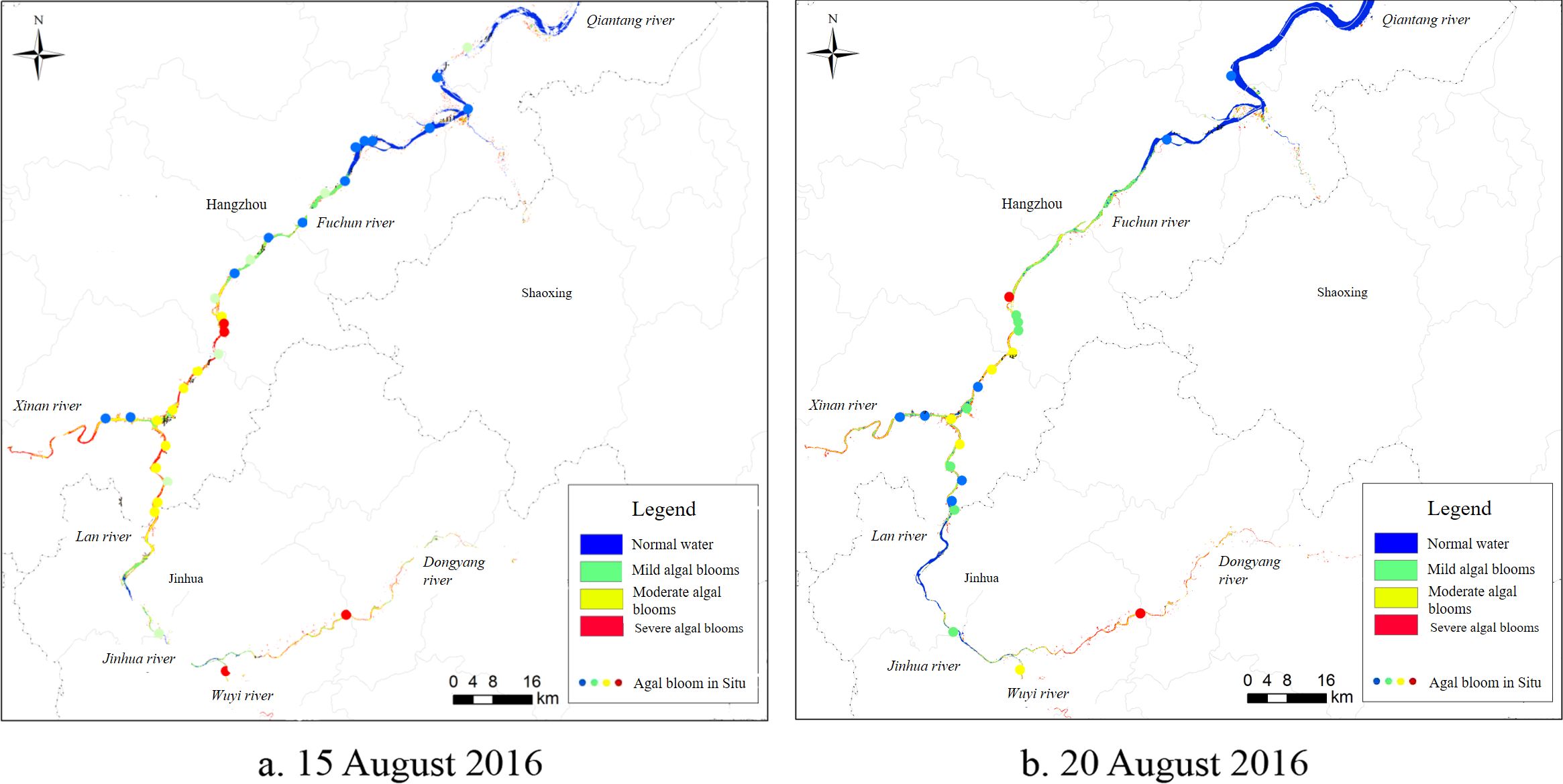
Figure 2. Validation of Qiantang river algal bloom remote sensing inversion against in situ measurements with (a) (August 15, 2016) and (b) (August 20, 2016).
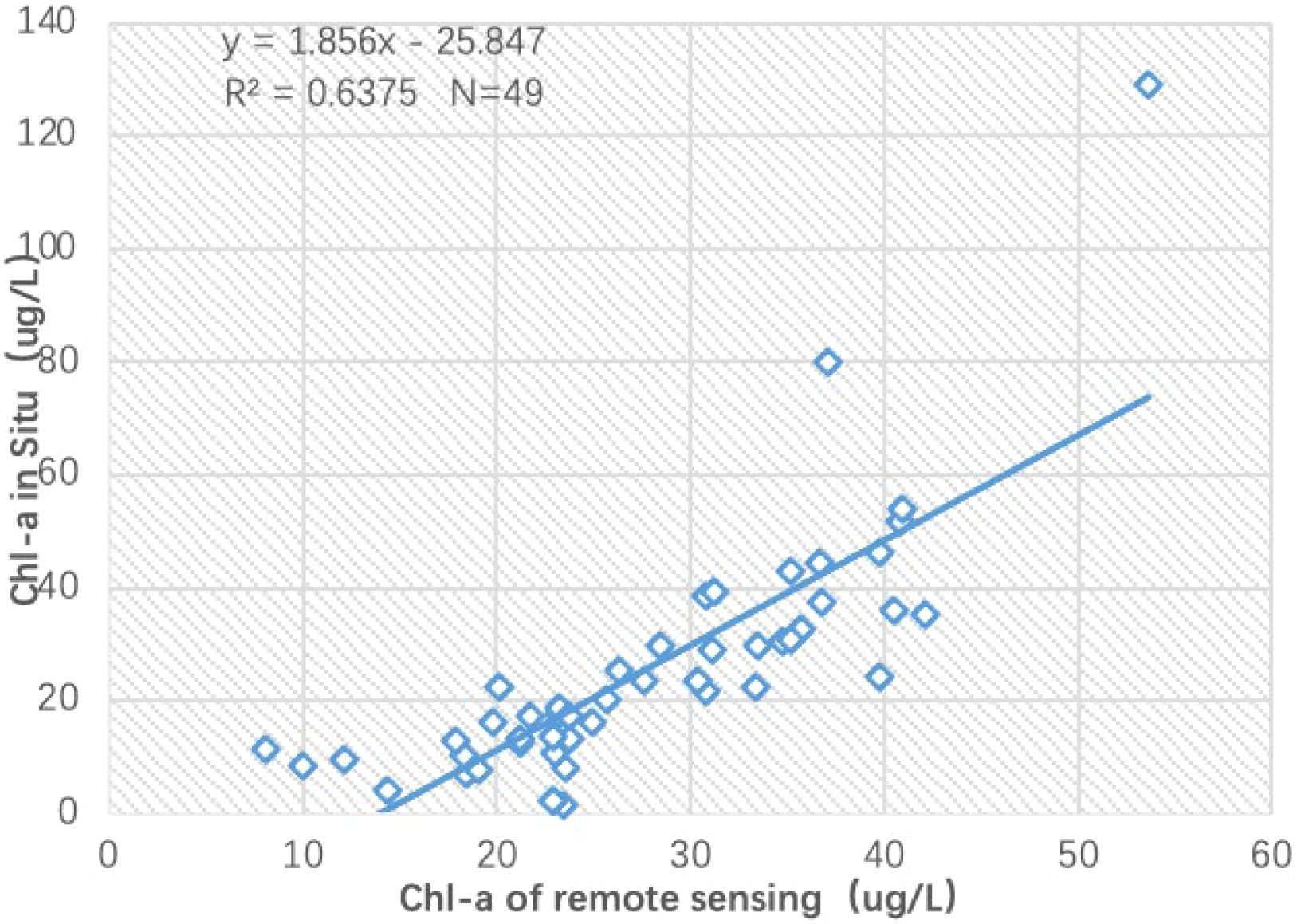
Figure 3. Accuracy validation of remote sensing retrieval for chlorophyll-a (Chl-a) in the Qiantang River.
As shown in Figure 3, the remotely sensed Chl-a concentration exhibits good linear agreement with in situ measurements (r=0.7984), demonstrating the capability of remote sensing to capture relative Chl-a concentration trends. The field-measured data exhibit significant fluctuations, whereas the remote sensing results demonstrate more gradual variations. The possible reason is that the water sampling collects data from a single point, while the remote sensing result represents the average concentration over a 30×30 meter pixel area of the water surface. This leads to a relatively smoother variation in the remote sensing data, analogous to a low-pass filtering effect.
4.2 Spatial distribution characteristics of algal blooms
Through the aforementioned remote sensing methodology, the spatial distribution of algal blooms in the Qiantang River during satellite overpass can be accurately obtained. Unlike ground-based monitoring which can only obtain data at discrete sampling points, satellite-derived results provide the spatial distribution of Chl-a in water bodies during satellite overpasses, enabling rapid identification of the most severe algal bloom areas. Through statistical analysis methods, the occurrence area and proportion of algal blooms in each river section can be obtained. Taking the remote sensing inversion results on August 20, 2016, as an example, the algal bloom area in the main reaches of the Qiantang River within the study region was 138.93 km². Among this, the areas of mild, moderate, and severe algal blooms were 41.72 km², 51.79 km², and 45.42 km², respectively, with moderate algal bloom exhibiting the highest proportion. The results are presented in Figure 4.
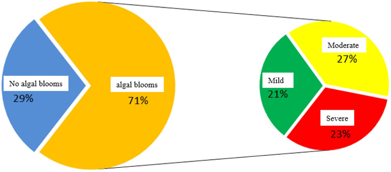
Figure 4. Areal percentage of algal blooms in key reaches of the Qiantang River.
Calculate the proportional area coverage of algal blooms at different severity levels for each river segment separately. On August 20, 2016, the Qiantang River mainstream section had the lowest proportion of algal bloom coverage. The Wuyi River and Xin’an River segments accounted for the largest proportion of severe algal bloom coverage, with approximately half of their water areas affected by intense blooms, as shown in Figure 5.
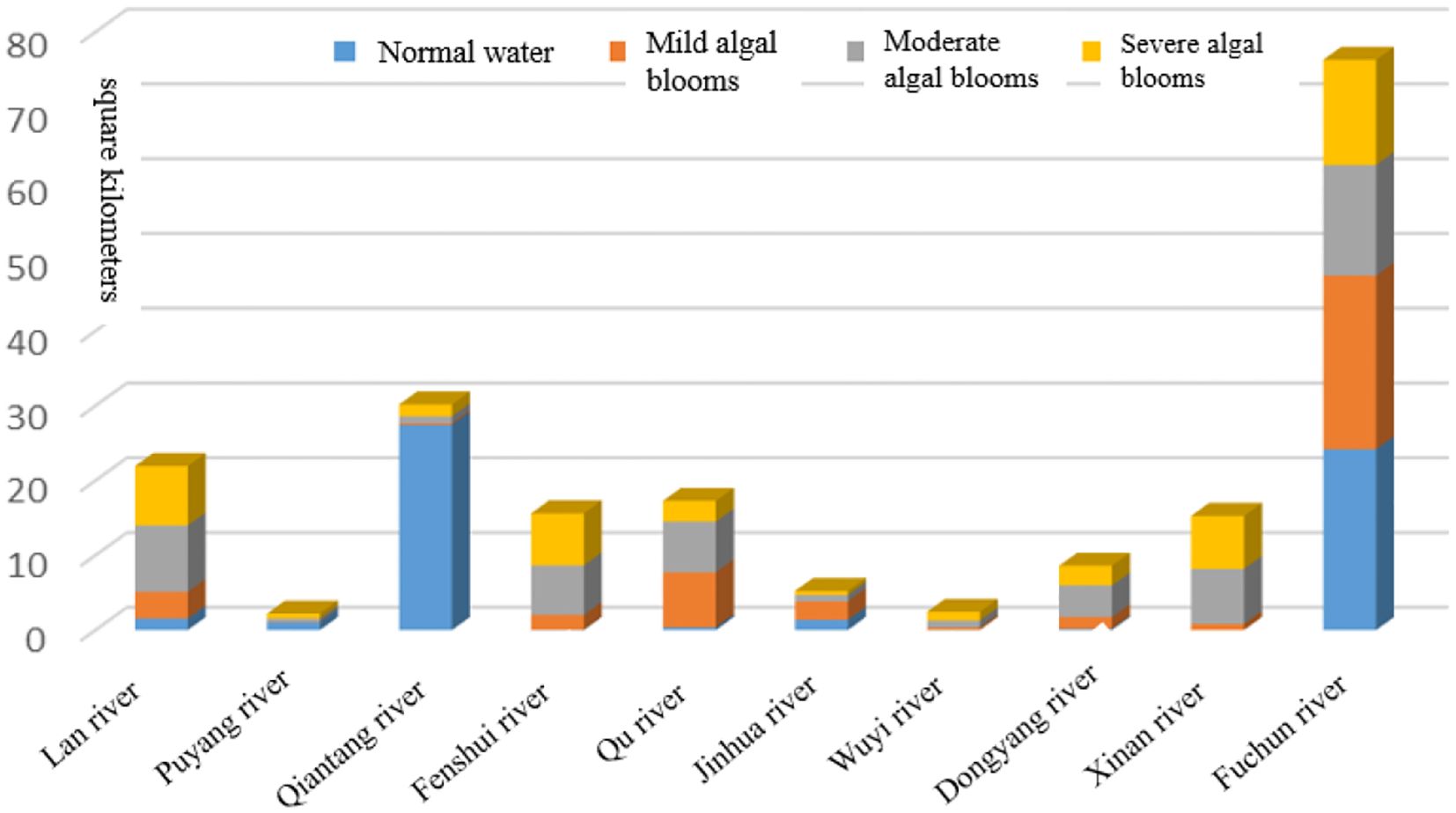
Figure 5. Distribution of algal bloom area in the main reaches of the Qiantang River water system.
4.3 Remote sensing monitoring of algal bloom evolution processes
Statistics and comparative analysis of multi-temporal remote sensing inversion results can elucidate the temporal evolution of algal blooms. Remote sensing analysis reveals that the algal bloom dynamics in the Qiantang River system, occurring from July to September 2016, exhibited four characteristic phases: incipient stage, proliferation stage, climax stage, and regression stage, as shown in Figure 6.
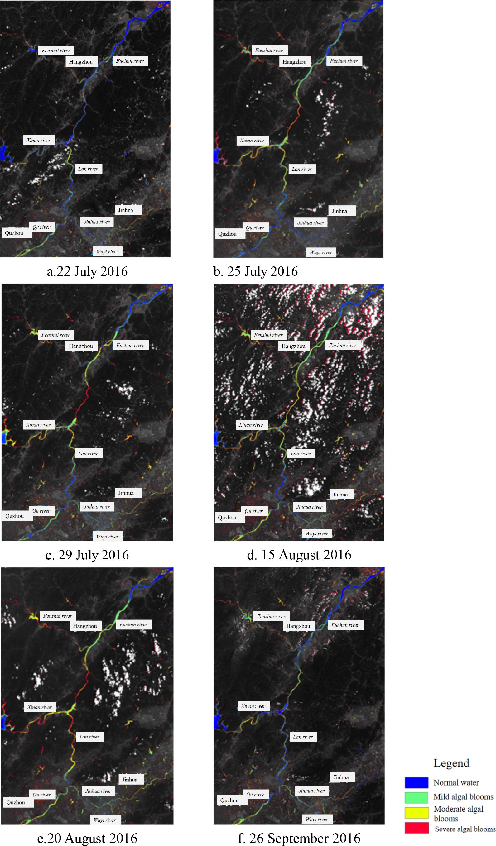
Figure 6. Satellite remote sensing of algal blooms of 2016 in the Qiantang river: (a) July 22, (b) July 25, (c) July 29, (d) August 15, (e) August 20, (f) September 26.
A. In the initial stage of algal bloom occurrence, as shown in the satellite remote sensing results of the Qiantang River water system on July 22, 2016, the bloom intensity was predominantly mild. A large area of moderate to severe algal blooms occurred in the river section between Lan river and Xin’an river and the confluence of the Fuchun river and Fenshui river. Meanwhile, the algal bloom area in major tributaries such as the Xin’an river further expanded, with increased bloom intensity.
B. During the algal bloom development phase, as shown by the satellite remote sensing results of the Qiantang River system on July 25, the spatial distribution of blooms in the main channel had expanded from the lower reaches of the Lan river to the Fuyang city section in the upper reaches of the Fuchun River, though the bloom intensity remained predominantly mild. A large area of moderate to severe algal blooms occurred in the river section between at the confluence of the Lan river and Xin’an river and the confluence of the Fuchun river and Fenshui river. Meanwhile, the algal bloom area in major tributaries such as the Xin’an River further expanded, with increased bloom intensity.
C. The peak bloom period, as demonstrated by the satellite remote sensing results of the Qiantang river water system on July 29, 2016. The distribution range of algal blooms in the main channel had covered the river section from the lower reaches of Lan river to the upper reaches of Fuchun river (Fuyang City segment). Meanwhile, large-scale severe algal blooms in other river sections further intensified with continued expansion in coverage area. After August 15th, the intensity of algal blooms in the Qiantang river water system began to intensify again. The satellite remote sensing results of algal blooms in the Qiantang river system on August 20 show that the distribution of algal blooms has spread throughout the main river channel upstream of the Qiantang river, as well as major tributaries such as the Xin’an river and Jinhua river. Moreover, severe algal blooms in the main channel have covered the Fuchun river and Lan river. The algal blooms in major tributaries such as the Xin’an river were also predominantly severe, reaching the peak of both distribution area and intensity during this bloom event. The algal bloom in the Qiantang river on August 24 maintained the outbreak status observed on August 20, with similar distribution patterns and coverage extent. The bloom had spread across the main channel upstream of Qiantang river, as well as major tributaries including the Xin’an river and Jinhua river.
D. The algal bloom decline phase, as demonstrated by the satellite remote sensing results of the Qiantang River water system on September 26, both the intensity and spatial distribution of the bloom gradually diminished after early September. By mid-to-late September, specifically around September 25, the river conditions had essentially returned to their original state.
5 Conclusion and prospects
Grounding in radiative transfer mechanisms, this research established a physics-driven model for Chl-a concentration retrieval from pixel reflectance of remote sensing. The model explicitly accounts for Chl-a, delivering transparent inversion mechanisms and physically interpretable parameters. By exclusively retrieving the surface Chl-a concentration, this approach can effectively reflect the actual conditions of algal blooms. Validation shows a good linear relationship (R=0.7984) between the remote sensing retrieval results and in situ measurements, confirming the reliability of satellite data in monitoring algal bloom dynamics in the Qiantang River.
Given the vast area of the Qiantang River Basin (approximately 50,000 km²), high-resolution satellites with limited swath width were inadequate for complete coverage. The study employed HJ-1A/B satellite data (Environment Satellite) which provides single-scene coverage of the entire study area. However, data availability was constrained by adverse weather conditions and satellite imaging schedules, with particularly scarce acquisitions during early-mid September and October when no usable data were available. Therefore, for emergency water quality monitoring of inland rivers and lakes, multi-source satellites such as Gaofen-1 (GF-1) or Sentinel can be employed to compensate for the temporal coverage limitations of single satellite. With the advancement of deep learning theory, integrating deep learning into quantitative remote sensing physical models is expected to improve the accuracy of remote sensing inversion as well as enhance the model’s dynamic predictive capabilities. This will achieve a transition from status monitoring to early warning of algal blooms for river systems.
Data availability statement
The original contributions presented in the study are included in the article/supplementary material. Further inquiries can be directed to the corresponding author.
Author contributions
ZZ: Conceptualization, Software, Investigation, Writing – review & editing, Funding acquisition, Resources, Writing – original draft, Project administration, Validation, Methodology, Visualization, Formal analysis, Supervision, Data curation. JL: Writing – original draft, Writing – review & editing. RD: Writing – original draft, Methodology, Investigation. ZH: Writing – review & editing, Validation, Writing – original draft. SP: Resources, Validation, Project administration, Conceptualization, Formal analysis, Data curation, Methodology, Visualization, Supervision, Writing – review & editing, Funding acquisition, Investigation, Software, Writing – original draft.
Funding
The author(s) declare that financial support was received for the research and/or publication of this article. This work was supported by Zhejiang Province “Pioneering Soldier” and “Leading Goose” R&D Project (Grant numbers: 2023C03011) and the National Natural Science Foundation of China (No. 42471445).
Acknowledgments
Author would like to thank potential supervisor, editor and reviewer for their advice and comment.
Conflict of interest
The authors declare that the research was conducted in the absence of any commercial or financial relationships that could be construed as a potential conflict of interest.
Generative AI statement
The author(s) declare that no Generative AI was used in the creation of this manuscript.
Publisher’s note
All claims expressed in this article are solely those of the authors and do not necessarily represent those of their affiliated organizations, or those of the publisher, the editors and the reviewers. Any product that may be evaluated in this article, or claim that may be made by its manufacturer, is not guaranteed or endorsed by the publisher.
References
Arshad T., Zhang J. P., and Ullah I. (2024). A hybrid convolution transformer for hyperspectral image classification. Eur. J. Remote Sens. 57, 2330979. doi: 10.1080/22797254.2024.2330979
Arshad T., Zhang J., Ullah I., Ghadi Y. Y., Alfarraj O., and Gafar A. (2023). Multiscale feature-learning with a unified model for hyperspectral image classification. Sensors 23, 7628. doi: 10.3390/s23177628
Binding C., Greenberg T., McCullough G., Watson S., and Page E. (2018). An analysis of satellite-derived chlorophyll and algal bloom indices on Lake Winnipeg. J. Great Lakes Res. 44, 436–446. doi: 10.1016/j.jglr.2018.04.001
Brooks B. W., Lazorchak J. M., Howard M. D., Johnson M. V., Morton S., Perkins D. A., et al. (2016). Are harmful algal blooms becoming the greatest inland water quality threat to public health and aquatic ecosystems? Environ. Toxicol. Chem. 35, 6–13. doi: 10.1002/etc.3220
Chang N.-B., Imen S., and Vannah B. (2015). Remote sensing for monitoring surface water quality status and ecosystem state in relation to the nutrient cycle: a 40-year perspective. Crit. Rev. Environ. Sci. Technol. 45, 101–166. doi: 10.1080/10643389.2013.829981
Chen J. Y., Chen S. S., Fu R., Li D., Jiang H., Wang C. Y., et al. (2022). Remote sensing big data for water environment monitoring: current status, challenges, and future prospects. Earth’s Future 10. doi: 10.1029/2021EF002289
Chen C., Liang J., Yang G., and Sun W. (2023). Spatio-temporal distribution of harmful algal blooms and their correlations with marine hydrological elements in offshore areas. China. Ocean Coast. Management 238, 106554. doi: 10.1016/j.ocecoaman.2023.106554
Deng C. B., Zhang L. F., and Cen Y. (2019). Retrieval of chemical oxygen demand through modified capsule network based on hyperspectral data. Appl. Sci. 9, 4620. doi: 10.3390/app9214620
EI-Rawy M., Fathi H., and Abdalla F. (2020). Integration of remote sensing data and in situ measurements to monitor the water quality of the Ismailia Canal, Nile Delta, Egypt. Environ. Geochem. Health 42, 2101–2120. doi: 10.1007/s10653-019-00466-5
Gao L., Shangguan Y., Sun Z., She Q., and Zhou L. (2025). A novel algal bloom risk assessment framework by integrating environmental factors based on explainable machine learning. Ecol. Inform. 87, 103098. doi: 10.1016/j.ecoinf.2025.103098
Guo Y., Deng R., Li J., Hua Z., Wang J., Zhang R., et al. (2022). Remote sensing retrieval of total nitrogen in the pearl river delta based on landsat8. Water 14, 3710. doi: 10.3390/w14223710
Ho J. C., Michalak A. M., and Pahlevan N. (2019). Widespread global increase in intense lake phytoplankton blooms since the 1980s. Nature 574, 667–670. doi: 10.1038/s41586-019-1648-7
Khan S., Ullah I., Ali F., Shafiq M., Ghadi Y.Y., and Kim T. (2023). Deep learning-based marine big data fusion for ocean environment monitoring: Towards shape optimization and salient objects detection. Front. Mar. Sci. 9. doi: 10.3389/fmars.2022.1094915
Li J., Deng R., Guo Y., Lei C., Hua Z., and Yang J. (2025). Quantitative estimation of organic pollution in inland water using sentinel-2 multispectral imager. Sensors 25, 2737. doi: 10.3390/s25092737
Li J., Zhang W., Deng R., Lu Z., Liang Y., Shen X., et al. (2022). The study of spatial-temporal characteristics for CODmn in shenzhen reservoir based on GF-1 WFV. J. Remote Sens. 26, 1562–1574. doi: 10.11834/jrs.20219380
Liang J., Chen C., Song Y., Sun W., and Yang G. (2023). Long-term mapping of land use and cover changes using Landsat images on the Google Earth Engine Cloud Platform in bay area-A case study of Hangzhou Bay, China. Sustain. Horizons 7, 100061. doi: 10.1016/j.horiz.2023.100061
Liang Y. J., Deng R. R., Liang Y. H., Tang Y. M, Xiong L. H, and Li J. Y. (2024). high-resolution remote sensing of chlorophyll-a across large basins. Remote Sens. Technol. Application 39, 1490–1499. doi: 10.11873/j.issn.1004⁃0323.2024.6.1490
Liu S., Glamore W., Tamburic B., Morrow A., and Johnson F. (2022). Remote sensing to detect harmful algal blooms in inland waterbodies. Sci. Total Environment 851, 158096. doi: 10.1016/j.scitotenv.2022.158096
Liu S., Xie Z., Liu B., Wang Y., Gao J., Zeng Y. J., et al. (2020). Global river water warming due to climate change and anthropogenic heat emission. Global Planetary Change 193, 103289. doi: 10.1016/j.gloplacha.2020.103289
Lu S., Deng R., Liang Y., Xiong L., Ai X., and Qin Y. (2020). Remote sensing retrieval of total phosphorus in the pearl river channels based on the GF-1 remote sensing data. Remote Sens. 12, 1420. doi: 10.3390/rs12091420
Mcfeeters S. K. (1996). The use of the normalized difference water index (NDWI) in the delineation of open water features. Int. J. Remote Sensing 17, 1425–1432. doi: 10.1080/01431169608948714
Rad A. M., Kreitler J., and Sadegh M. (2021). Augmented normalized difference water index for improved surface water monitoring. Environ. Model. Software 140, 10503. doi: 10.1016/j.envsoft.2021.105030
Reinl K. L., Sterner R. W., Lafrancois B. M., and Brovold S. (2020). Fluvial seeding of cyanobacterial blooms in oligotrophic Lake Superior. Harmful Algae 100, 101941. doi: 10.1016/j.hal.2020.101941
Rolim S. B. A., Veettil B. K., Vieiro A. P., and Kessler A. B. (2023). Remote sensing for mapping algal blooms in freshwater lakes: a review. Environ. Sci. Pollut. Res. 30, 19602–19616. doi: 10.1007/s11356-023-25230-2
Ruescas A. B., Hieronymi M., Mateo-Garcia G., Koponen S., Kallio K., and Camps-Valls G. (2018). Machine learning regression approaches for colored dissolved organic matter (CDOM) retrieval with S2-MSI and S3-OLCI simulated data. Remote Sens. 10, 786. doi: 10.3390/rs10050786
Sukharevich V. I. and Polyak Y. M. (2020). Global occurrence of cyanobacteria: causes and effects (review). Inland Water Biol. 13, 566–575. doi: 10.1134/S1995082920060140
Sun Q., Zhang C., Liu M., and Zhang Y. (2016). Land use and land cover change based on historical space–time model. Solid Earth 7, 1395–1403. doi: 10.5194/se-7-1395-2016
Suresh K., Tang T., Michelle T. H., Marc F. P., Maryna S., Florian S. D., et al. (2023). Recent advancement in water quality indicators for eutrophication in global freshwater lakes. Environ. Res. Lett. 18, 063004. doi: 10.1088/1748-9326/acd071
Ullah I., Ali F., Ali A., Naeem H. M. Y., and Bai X. (2024). Optimizing underwater connectivity through multi-attribute decision making for underwater IoT deployments using remote sensing technologies. Front. Mar. Sci. 11. doi: 10.3389/fmars.2024.1468481
Van Vliet M. T. H., Thorslund J., Strokal M., Hofstra N., Florke M., Macedo H. E., et al. (2023). Global river water quality under climate change and hydroclimatic extremes. Nat. Rev. Earth Environ. 4, 687–702. doi: 10.1038/s43017-023-00472-3
Vasilakos C., Kavroudakis D., and Georganta A. (2020). Machine learning classification ensemble of multitemporal sentinel-2 images: the case of a mixed mediterranean ecosystem. Remote Sens. 12, 2005. doi: 10.3390/rs12122005
Vinothkumar J. and Karunamurthy A. (2023). Recent advancements in artificial intelligence technology: trends and implications. Quing Int. J. Multidiscip. Sci. Res. Dev. 2 (1), 1-11. doi: 10.54368/qijmsrd.2.1.0003
Wang Y. K., Zhang N., Wang D., and Wu J. C. (2020). Impacts of cascade reservoirs on Yangtze River water temperature: Assessment and ecological implications. J. Hydrol. 590, 125240. doi: 10.1016/j.jhydrol.2020.125240
Xiao Y., Guo Y. H., Yin G. D., Zhang X., Shi Y., Hao F. H., et al. (2022). UAV multispectral image-based urban river water quality monitoring using stacked ensemble machine learning algorithms-a case study of the zhanghe river, China. Remote Sens. 14, 3272. doi: 10.3390/rs14143272
Yang J., Deng R., Ma Y., Li J., Guo Y., and Lei C. (2025). Satellite retrieval and spatiotemporal variability in chlorophyll-a for marine ranching: an example from daya bay, guangdong province, China. Water 17, 780. doi: 10.3390/w17060780
Yang H., Kong J., Hu H., Du Y., Gao M., and Chen F. (2022). A review of remote sensing for water quality retrieval: progress and challenges. Remote Sens. 14, 1770. doi: 10.3390/rs14081770
Yang Y. C., Zhang D. H., Li X. S., Wang D. M., Yang C. H., and Wang J. H. (2023). Winter water quality modeling in xiong’an new area supported by hyperspectral observation. Sensors 23, 4089. doi: 10.3390/s23084089
Zhang D. H., Zhang L. F., Sun X. J., Gao Y., Lan Z. Y., Wang Y. N., et al. (2022). A new method for calculating water quality parameters by integrating space-ground hyperspectral data and spectral-in situ assay data. Remote Sens. 14, 3652. doi: 10.3390/rs14153652
Keywords: chlorophyll-a (Chl-a), algal bloom, remote sensing, Chl-a remote sensing physical model, seagoing river
Citation: Zhang Z, Liu J, Deng R, Hu Z and Pan S (2025) Satellite remote sensing of algal blooms in seagoing river in Eastern China. Front. Mar. Sci. 12:1620021. doi: 10.3389/fmars.2025.1620021
Received: 29 April 2025; Accepted: 17 June 2025;
Published: 09 July 2025.
Edited by:
Chao Chen, Suzhou University of Science and Technology, ChinaReviewed by:
Inam Ullah, Gachon University, Republic of KoreaMengmeng Yang, Taishan University, China
Copyright © 2025 Zhang, Liu, Deng, Hu and Pan. This is an open-access article distributed under the terms of the Creative Commons Attribution License (CC BY). The use, distribution or reproduction in other forums is permitted, provided the original author(s) and the copyright owner(s) are credited and that the original publication in this journal is cited, in accordance with accepted academic practice. No use, distribution or reproduction is permitted which does not comply with these terms.
*Correspondence: Shuping Pan, emhhbmcwNTd4dUAxNjMuY29t