Abstract
The feasibility of using unoccupied aerial vehicles (UAVs, ‘drones’) to collect high-resolution still and video imagery of dugongs (Dugong dugon) for photo-identification (photo-ID) in the Sindalah Archipelago, NEOM (area ~ 84 km2), within the northeast Red Sea, Saudi Arabia, was evaluated during opportunistic marine megafauna searches. Drone searches were conducted whenever possible over one year (January 2024 to January 2025). A total of 48 dugong observations were made during 91 days of drone flights, covering a cumulative distance of 5,962 km of flying. Of these, 35 (72.9%) were repeat sightings (range = 2 to 8 resights) of nine individuals, identified using tail-fluke notches, scars on the dorsum, or both. The time between first and last sightings ranged from 12 days to 10.5 months, with maximum linear distances between all sightings of individuals ranging 0.71 to 5.12 km (mean = 2.4 km; SD = 1.8 km). The ranges of individuals appeared relatively small, suggesting potential site fidelity. To our knowledge, this represents the first drone-based photo-ID study for dugongs using a combination of fluke markings and scarring, and suggests this technique can yield important data for dugong populations, at least over small spatial and temporal scales. Given the relatively small, low-density population of dugongs in the northeast Red Sea, and threats posed by coastal development in the region, a better understanding of spatial and temporal habitat use of individuals is required. This study will support species management decisions, contributing to conservation of dugongs in the region.
1 Introduction
Dugong (Dugong dugon) populations are highly vulnerable to human impacts as a result of their life history characteristics together with their reliance on seagrass habitats that are commonly found in coastal and island areas coinciding with high human population density (Marsh et al., 2025). According to the IUCN Red List of Threatened Species, dugongs are classed as Vulnerable globally (Marsh and Sobtzick, 2019), however, where some subpopulation assessments have been carried out, the species has been found to be Critically Endangered, e.g., East Africa (Trotzuk et al., 2022) and Nansei, Japan (Brownell et al., 2019), or Endangered, e.g., New Caledonia (Hamel et al., 2022). These subpopulation assessments demonstrate that the IUCN Red List global status of Vulnerable is likely inappropriate throughout some parts of the dugong’s range, much of which is thought to be highly fragmented and lacking in localized subpopulation data (Marsh et al., 2025).
In the Red Sea, the status of dugong populations remains poorly understood due to limited research efforts. Preen (1989) suggested that the Red Sea population could potentially comprise up to 4,000 dugongs, however, this was based on surveys conducted in Saudi Arabia in the 1980s and extrapolating to the African coastline. This has not since been verified and the size and status of dugong population of the Red Sea remains largley unknown (Schramm et al., 2025). A recent study by Shawky et al. (2024) in the northwest Egyptian Red Sea estimated there to be a relatively small, threatened population of 73 to 97 individuals in that area. The population of dugongs in the adjacent northeast Saudi Arabian Red Sea is likely to be similarly small in size (Preen, 1989; Nasr et al., 2019) and facing similar anthropogenic threats. With the tourism sector rapidly expanding in parts of the Red Sea, increased marine traffic and habitat fragmentation is expected to intensify pressures on local dugong populations and their sensitive seagrass foraging habitats. This increased pressure highlights the need for more comprehensive studies to assess dugong density, distribution and spatial movements in Red Sea waters.
The Sindalah Archipelago, situated in NEOM in the northeast Saudi Arabian Red Sea, is an area consisting of a series of islands creating a semi-enclosed lagoon adjacent to the mainland (see Figures 1, 2). High water clarity and a bathymetry profile with a maximum depth of approximately 36 m provides ideal conditions for a mosaic of habitats, particularly rich in coral reefs and seagrass. The archipelago comprises a complex marine life community structure where coral reefs provide a rich prey base for large predators (cetaceans, sharks and rays), while seagrass beds support marine herbivores such as green turtles (Chelonia mydas) and dugongs. Khamis et al. (2022) surveyed dugong feeding sites across the northeastern Red Sea to identify priority conservation areas, one of which included the Sindalah Archipelago. The findings of that study highlighted that many high-use dugong areas overlap with regions already experiencing human disturbances, including vessel traffic, fishing, and coastal development. Where the distribution of dugongs overlaps with potential anthropogenic threats, a better understanding of the number of dugongs in key areas and to what degree individuals are either resident or transient between those areas is required to mitigate risks such as potential vessel-strikes, disturbance or habitat degradation.
Figure 1
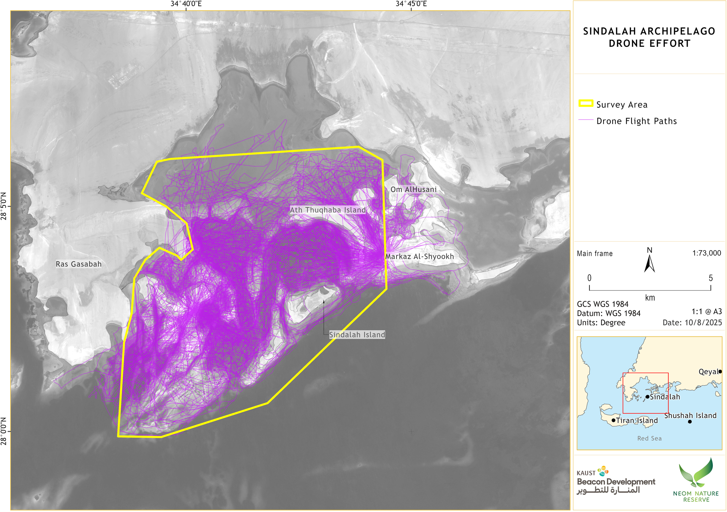
Drone flight paths flown in the Sindalah Archipelago during focal searches from January 2024 to January 2025. The “Survey Area” was systematically surveyed during the same period (in a separate study) and formed the study area for this work.
Figure 2
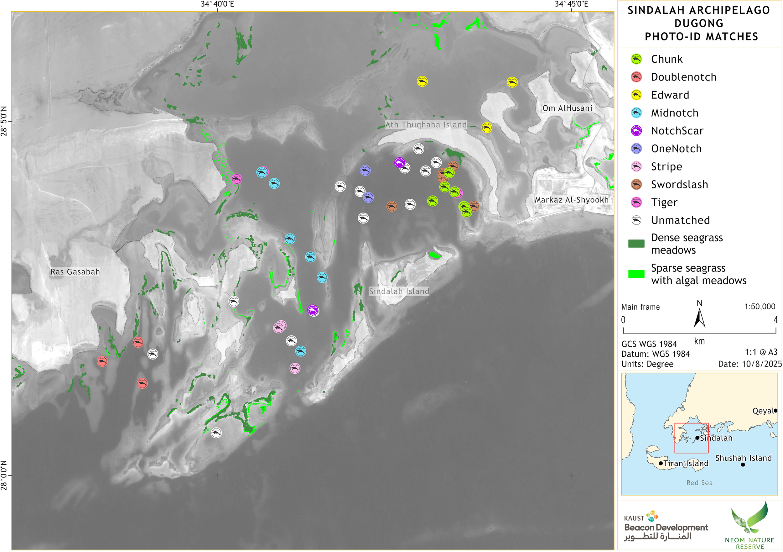
Locations of individual dugong sightings photo-ID matched in the Sindalah Archipelago from January 2024 to January 2025. Satellite-derived seagrass habitat is also shown for reference, though this does not reflect the full extent of seagrass, particularly small seagrass species that dugongs prefer.
Photo-identification (photo-ID) is a widely used, non-invasive technique to identify individuals of several marine megafauna species such as whales, dolphins, sea turtles, manatees and seals, to quantify spatial and temporal movements and habitat use, and to estimate population size (Karlsson et al., 2005; McGuire and Henningsen, 2007; Brereton et al., 2017; Lavin, 2017; Landeo-Yauri et al., 2020; Beck, 2022; De Weerdt et al., 2023; Neves-Ferreira et al., 2023; Meyer et al., 2024; Edison et al., 2024). By capturing unique physical features such as scars, notches, or pigmentation patterns, photo-ID can provide valuable information on site fidelity, seasonal movement patterns, and behavior.
In the context of dugongs, a few photo-ID studies have successfully used scars (Anderson, 1995; D’souza and Patankar, 2009; Yamato et al., 2024), as well tail-fluke notches (Shawky et al., 2019), to identify and resight individual dugongs over time in India, Egypt, Thailand, and Australia. Anderson (1995) photographed scars on the dorsum and heads of dugongs from a vessel in Shark Bay, Western Australia, and was able to re-identify five individuals on 14 occasions over several days up to a maximum of two months. In a study by Shawky et al. (2019) in Egypt, photographic imagery taken underwater was used for photo-ID, which enabled researchers to record spatial movements of eight individual dugongs within the study site. Similar methods have also been used for West Indian manatees, where photo-ID of tail notches and scars conducted during health assessments supported long-term monitoring programs across Florida and the Caribbean (Beck, 2022; Castelblanco-Martínez et al., 2022). However, in their natural habitat, the elusive nature of dugongs, along with their lack of dorsal fin or fluke-up dive behavior, presents several challenges for conducting photo-ID, both at the surface from a vessel, or during underwater photography. Dugongs are cryptic, low-profile animals that often flee from disturbances such as boats and divers, making both surface and subsurface observations challenging (Anderson, 1982).
Unoccupied aerial vehicles (UAVs, ‘drones’) offer a promising, cost-effective, non-invasive alternative for monitoring marine megafauna species, providing aerial views which can facilitate the detection and counting of individual animals (Hodgson et al., 2013; Ahmad et al., 2019; Landeo-Yauri et al., 2020; Cleguer et al., 2021). Beyond estimates of abundance, density and distribution, high-resolution drone imagery also presents the opportunity to collect other biological information. An example of this has been the use of photogrammetry to assess and monitor the physical condition of cetacean species (Bierlich et al., 2021; Álvarez-González et al., 2023; de Oliveira et al., 2023). These studies demonstrate that small drones, and the imagery that they are able to attain, can address a variety of ecological and conservation research questions. Additionally, small drones offer tools, and associated methodologies, that fit within the financial and technical capacities of scientists working in range states of species where funding may be limited, such as for dugongs.
In the case of dugong photo-ID, drones can capture high-resolution imagery of individuals, allowing for the identification of natural markings and scarring patterns. Yamato et al. (2024) used drone imagery to identify 64 individual dugongs in Thailand by exclusively matching dorsal body scarring, recording resights of 26 individuals over a maximum of 9.5 months. In a recent study in Qatar, drones were used to assess the population structure of dugongs, providing the country with valuable data on its understudied local populations (Patel et al., 2025). An incidental finding of the study by Patel et al. (2025) was that they could identify 27 individual dugongs by comparing permanent spots and markings on their dorsum and tail flukes (not including body scarring), though the resight rate was low (three individuals over an undisclosed time period). Both studies by Yamato et al. (2024) and Patel et al. (2025) show the potential for drone imagery to be used for dedicated photo-ID studies of dugongs for the purposes of tracking individual habitat use both spatially and temporally.
This study aimed to assess the use of aerial drone imagery for identifying individual dugongs using body scars and/or tail fluke notches in the northeastern Red Sea over a one-year period. As a secondary outcome, this photo-ID assessment was used to provide preliminary insights into dugong spatial and temporal habitat use within the Sindalah Archipelago. As an alternative to invasive tagging methods, photo-ID offers a non-disruptive means of monitoring individuals, particularly in data-deficient regions such as the northeast Red Sea. Understanding the density and distribution, as well as the spatial and temporal habitat use of individual dugongs, alongside the population as a whole within the Red Sea, is necessary to inform conservation strategies and ensuring the species’ survival in the region.
This study’s objectives were to: 1) assess the feasibility of drone imagery for identifying individual dugongs in the study area over one year, using distinguishing features (body scars and tail fluke notches); 2) develop a photo-ID catalogue of dugongs in the Sindalah Archipelago; and 3) provide preliminary insights into dugong habitat use. These findings contribute to a growing body of research supporting non-invasive monitoring techniques and offer baseline data to inform future conservation planning in the Sindalah Archipelago.
2 Materials and methods
2.1 Study site
The study site is located in the Sindalah Archipelago in the northeast Red Sea, Saudi Arabia (28° 3’36.00”N, 34°41’53.52”E) (see Figures 1, 2). Spanning approximately 84 km2, the study site consists of a series of islands adjacent to the mainland that create a semi-enclosed area from the wider Red Sea. Maximum water depths reach approximately 36 m, however, the overall topography is characterized by having extensive areas of shallow water (2 to 10 m) with coral reefs and seagrass beds.
2.2 Drone flights
Focal drone searches were conducted opportunistically between 10 January 2024 and 02 January 2025 over different parts of the study area using a multi-rotor drone. These were interspersed with fixed-wing drone transect surveys aimed at determining overall dugong density and distribution. The focus of this publication is the results of focal drone searches as drone transect survey imagery was taken at an altitude (150 m) that resulted in image resolution insufficient for photo-ID. The drone model used for focal drone searches (DJI Matrice 30T, 48-megapixel still images, 4K video) is capable of taking high-quality still photos and video imagery, while a 16x optical zoom reduces the need to fly at low altitudes. All flights were conducted at altitudes of no less than 100 m, which minimized the potential for animals to be disturbed and provided context within the study area, as per recommendations by Infantes et al. (2020). Drone deployments were made from land, and though flight paths were relatively ad hoc, the aim was to achieve representative coverage of the area covered by weekly systematic transect surveys, weather and time permitting (i.e. transect surveys were prioritized).
2.3 Drone imagery capture
All sightings of dugongs were immediately confirmed in the field via live imagery on the drone controller. When a dugong was sighted during a focal search, the drone remained directly above the animal as long as the battery consumption allowed, and both video and still imagery were captured. Efforts were made during each sighting to capture imagery of the head, torso and tail flukes in order to maximize the possibility of photo-ID matches with previous or subsequent sightings. The focus of the focal searches during the first half of the year was to capture imagery of the focal dugong while at the surface, resulting in several short videos and still imagery of individuals, whilst during the latter half of the year, the aim was to conduct focal follows where video was filmed continuously for as long as possible (determined by drone battery endurance). All imagery collected of the same individual dugong on the same day was considered one ‘observation’ of that individual dugong. The captured imagery saved onboard the drone was transferred back to offices at KAUST via a proprietary cloud service on the same day when field personnel had returned to their accommodation. Imagery was then available for image reviewers to download and analyze.
2.4 Drone imagery analysis
All imagery was analyzed manually ‘by eye’ by two reviewers. Although the reviewers were not fully blind to the dataset, as both reviewers had contributed to making matches during data collection, a structured verification process was implemented. Matches were firstly made using an iterative process as the data were being collected. Post data collection, an independent reviewer then reanalyzed all imagery to verify matches and determine whether any matches had been missed. Each dugong observation was initially assigned an identification based on the observation date and an alphanumeric code. Dugongs were then assigned individual names when more than one sighting of the same individual could be confirmed via photo-ID matches. Photo-ID matches were primarily made using high-quality still images that allowed for scars across the entire body and/or notches in the tail fluke to be identifiable in the same individual between different sightings. This was not always possible if the animal’s behavior dictated that sections of the body remained underwater, or markings were obscured by glare, sea surface conditions or poor imagery lighting, which reduced the amount of time that scars and/or fluke markings were visible. When this was the case, video imagery was examined using screenshots or slow motion to discern markings.
Image reviewers categorized all imagery depending on whether they resulted in photo-ID matches, simply assigning them as matched or unmatched without further assigning a confidence score. Where photo-ID matches of individuals could not be made, the imagery attained during each drone focal search sighting was categorized according to the cause, which included: (1) imagery of insufficient quality or quantity, (2) the conditions (e.g., high sea state or high glare), and (3) animals not being sufficiently marked to be able to make photo-ID matches and/or the behavior of animals being such that the body and tail fluke remained underwater. Finally, a separate category was assigned to unmatched individuals where there were sufficient markings to expect a photo-ID match to be made but where no recaptures were obtained during this study.
2.5 Spatial distribution of matched dugong observations
The GPS locations of the matched dugongs were extracted from the first still image (EXIF data) captured for each observation and then plotted using ArcGIS Pro. Mapping was conducted after the matching process to ensure independence (i.e., so that the proximity of the observations to one another did not bias matching decisions). Maximum straight-line distances between the observations of individual dugongs were determined by directly measuring these in ArcGIS Pro (Esri Inc.).
3 Results
3.1 Drone coverage and image capture
Over the course of the one-year study period, drone focal searches were conducted opportunistically on 91 days from January 2024 to January 2025. Drone focal searches for the purposes of photo-ID resulted in a cumulative search distance of approximately 5,962 km. Within those 91 days, a total of 48 dugong observations were made, all of which were of individuals rather than pairs or groups. Notably, none of the observations included mother/calf pairs or groups, a result supported by concurrent fixed-wing drone transect surveys (NEOM, 2025, unpublished data). The length of each observation (taken as the total length of all videos recorded during that observation) varied from 00:04 to 36:07 (min:s; mean = 04:18 min, SD = 06:32 min), and the number of surfacings (during which it was more likely that ID could be assessed) per observation ranged from 0 to 19 surfacings (mean = 3.8 surfacings per observation, SD = 3.6). Drone focal search data are summarized in Supplementary Table 1 and Supplementary Table 2.
Drone focal search effort is shown in Figure 1, demonstrating that despite splitting resources between different field methods, as well as experiencing inclement weather conditions (high winds), technical issues and permitting constraints which prevented drone flights on some days, a large proportion of the Sindalah Archipelago study site was repeatedly sampled, providing a relatively representative coverage of the intended study area, as well as some coverage outside of the intended area.
3.2 Photo-ID matched individuals
The imagery attained during drone focal searches allowed for photo-ID matches to be made on 35 (72%) observations, while for the remaining 13 (28%) sightings, photo-ID matches were not possible. For the cases where photo-ID matches could not be made, the primary reason was footage quality/quantity (n = 9) caused by poor lighting (e.g., imagery was over-exposed) or very short observations, sometimes in combination with other factors such as behavior (i.e., the dugong dived without bringing its fluke close enough to the surface; n = 2)), and/or the conditions (i.e., high sea state and the consequential glare). For three observations, there were markings visible but not matched (although in two of those, there was no clear fluke image obtained and markings were just on the dorsum). For one observation the dugong did not have any markings on its dorsum, but no fluke image was obtained.
A total of nine individuals were matched on more than one occasion (range = 2 to 8 resights). For ease of reference and remembering individuals during image processing, names were assigned to each photo-ID matched animal based on physical characteristics, a practice commonly adopted in other animal photo-ID catalogues (Lavin, 2017; Shawky et al., 2019; Neves-Ferreira et al., 2023). The type of imagery used to make matches using either body scars, tail fluke notches/scars, or a combination of both, is shown in Figure 3. The assigned physically descriptive names for each individual, a description of markings used to identify individuals and the number of times they were sighted are included as a photo-ID catalogue in the online Supplementary Material.
Figure 3
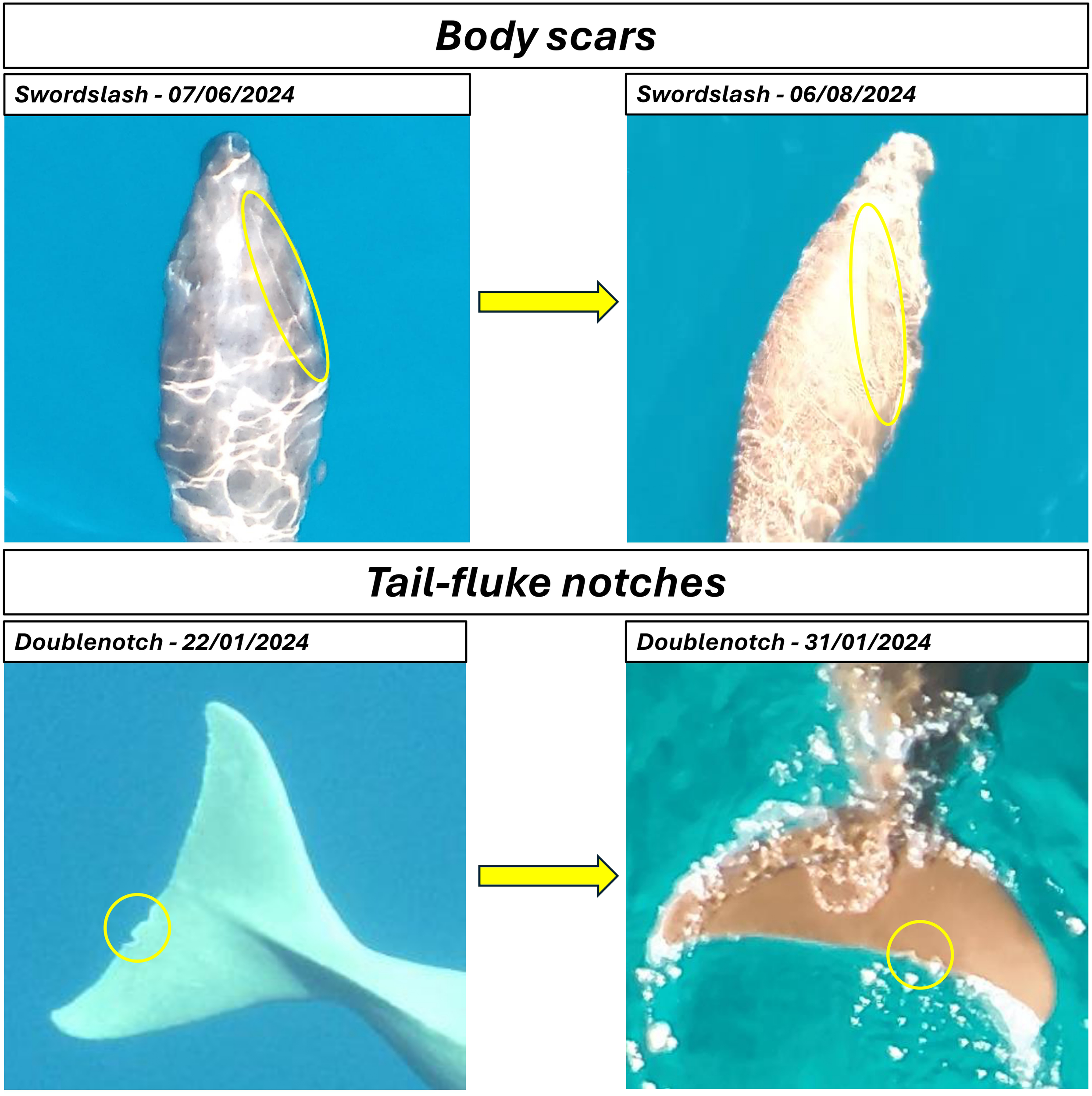
Example imagery of individual dugongs photo-ID matched in the Sindalah Archipelago from January 2024 to January 2025.
3.3 Spatial and temporal extent of photo-ID matches
The resights of each individual, all made on separate days, are summarized in Table 1 and shown spatially in Figure 2. Five of the nine individuals (Chunk, Midnotch, Doublenotch, Tiger and Onenotch) were identified using fluke notches, which may be less prone to healing than body scars and therefore are more likely to be the means by which photo-ID matches are made in further studies. Five individuals were identified using body scars (including dark marks or fresh scratches) including one for which both flukes and scars were used. As shown in Table 1, the maximum time across all observations was over 10 months for two individuals (Chunk and Midnotch). Both individuals had fluke notches that were used for ID. The maximum time between matched observations was almost 7 months, which was also for an individual (OneNotch) that had a recognizable fluke notch. For the individuals that were only identified using scars, the maximum time between successive matches was 3 months, but most were 1 month or less. Notably, though Chunk was identified using both fluke notches and a small and large scar, the latter was the main marking used for matching over the 10+ months. This was a particularly large scar which was a fresh wound on the first sighting. The results of this study, therefore, demonstrate that at least some individual dugongs can be photo-ID matched on a temporal scale of more than 10 months based on a combination of scarring that is tracked over time for healing, and fluke notches when present.
Table 1
| Individual | No. of resights | Match criteria (Scars/Fluke Notches/Both) | Time between first and last observation (months, days) | Maximum time between matches | Maximum linear distance between matches |
|---|---|---|---|---|---|
| Chunk | 8 | Both | 10 m, 19 d | 4 m, 22 d | 1.1 km |
| Midnotch | 6 | Flukes | 10 m, 13 d | 4 m, 21 d | 4.75 km |
| Swordslash | 5 | Scars | 1 m, 30 d | 0 m, 29 d | 1.9 km |
| Doublenotch | 3 | Flukes | 0 m, 12 d | 0 m, 9 d | 1.09 km |
| Edward | 3 | Scars | 0 m, 27 d | 0 m, 26 d | 2.08 km |
| Stripe | 3 | Scars | 3 m, 8 d | 3 m, 5 d | 1.16 km |
| Tiger | 3 | Flukes | 4 m, 14 d | 4 m, 11 d | 5.12 km |
| Notchscar | 2 | Scars (on flukes) | 1 m, 4 d | 1 m, 4 d | 4.33 km |
| OneNotch | 2 | Flukes | 6 m, 27 d | 6 m, 27 d | 0.71 km |
Summary of the number of dugong photo-ID matched resights (separate days), photo-ID match criteria, maximum time and maximum linear distance between photo-ID matches.
Table 1 also summarizes the maximum linear distance between photo-ID matched observations of individuals. It should be noted that straight-line distances between sightings were used as it was not possible to reconstruct true movement paths between matches that may have been influenced by island or reef barriers. The mean maximum distance between all observations per individual was 2.4 km (SD = 1.8 km), with the largest being ~4–5 km for Midnotch, Tiger, and Notchscar, who were sighted 2–6 times over 1 – 10.5 months. The remaining six individuals were sighted within shorter distances of 2 km or less over durations of <1 month to 10.5 months. It should also be noted that it was not possible to determine to what extent animals moved between photo-ID matched observations, nor was it possible to determine whether animals moved into or out of the study area, so these distances do not necessarily reflect the full ranging pattern of these individual dugongs. However, these data suggest that individual dugongs remained in, or revisited, fairly localized areas within the study area. For example, all sightings of Chunk, which spanned 10+ months, were in the lagoon on the inside of Ath Thuqhaba Island (see Figure 2), with a maximum distance between sightings of 1.1 km.
4 Discussion
4.1 Drone-based photo-ID
This study demonstrates the feasibility of using drone-based photo-ID to monitor individual dugongs in the Sindalah Archipelago. Over a one-year period, multiple individuals were identified and resighted using distinguishing features such as body scars and tail-fluke notches. These features enabled the creation of a photo-ID catalogue and provided insights into dugong site fidelity and spatial movements of a low-density dugong population within the study area. Previous studies have also identified individual dugongs using aerial drone imagery, allowing for inference about spatial movements (Yamato et al., 2024; Patel et al., 2025). As well as developing more evidence of the efficacy of drone-based photo-ID of dugongs, the present study aligns with the findings of the study by Yamato et al. (2024) by providing insight into site fidelity of individuals within the Sindalah Archipelago.
The results of drone focal searches carried out over the course of one year in the Sindalah Archipelago have shown that the use of drones and photo-ID is a highly effective research technique, allowing for a minimum of nine individuals to be photo-ID matched between repeat sightings within the study area. Compared to Yamato et al. (2024), who used dorsal scarring alone over a similar study timeframe, the use of both fluke notches and body scars in the present study may have contributed to the relatively high resight rate observed. It is important to note, however, that this relatively high resight rate ikely also reflects a small number of individual animals within the Sindalah Archipelago utilizing a small, predictable core seagrass habitat.
4.2 Unmatched dugong sightings and limitations
Of the 48 dugong sightings made during the year-long study period in the Sindalah Archipelago, 13 (27.1%) were unable to be photo-ID matched. Photo-ID matching generally proved to be difficult when environmental conditions such as high glare, high winds or high sea state affected image quality, reducing image reviewers’ ability to analyze still photos and videos. This, in combination with the cryptic behavior of animals adopting a low profile in the water column and much of the body remaining underwater, as described by Shawky et al. (2019) and Anderson (1995), reduced the possibility of being able to see scars and/or tail fluke notches. Given these challenges with image quality, animal behavior, and reliance on manual rather than automated image processing, the occurrence of false negatives, i.e., missed matches, cannot be ruled out.
In the present study, video imagery proved advantageous for matching individuals when visibility of markings was only fleeting, enabling still image captures to be taken from the video footage to confirm photo-ID to previously catalogued dugongs. Successful capture of video imagery suitable for photo-ID was dependent on good quality footage (i.e., suitable exposure levels and in-focus) which was not always obtained when these camera settings were set to auto (i.e., were adjusting automatically). Camera settings would therefore need to be adjusted manually to ensure they remain constant as the dugong moves through the water column. In future studies, a protocol outlining the methods of image capture should be developed to reduce the incidence of unmatched sightings resulting from poor image quality. Further to this, future survey designs should standardize flight paths and survey timing to enable assessment of detection probability.
4.3 Photo-ID matched dugongs and scarring
In total, 48 dugong sightings resulted in 35 (72.9%) photo-ID matches over the course of this study. This included repeat sightings of nine individuals where the reviewers could be certain of identification based on distinct markings, i.e., scars and/or tail-fluke notches. In a previous study by Shawky et al. (2019), some scarring on individual dugongs was shown to heal and completely disappear in a timeframe of approximately four months. Similar research by Anderson (1995) confirmed this is the case for superficial scarring but suggested that deeper scars can be more permanent and therefore used to track individuals over several years (Shawky et al., 2019; Anderson, 1995).
In the present study in the Sindalah Archipelago, Chunk was photo-ID matched over a period of 10.5 months, providing evidence to support the findings of Anderson (1995) that the longevity of some scarring persists at least in the order of several months. Notably, this individual was photo-ID matched using a combination of a small scar on the head initially, a large scar on the left shoulder and a tail-fluke notch. Over the course of 10.5 months, the scar on the head was observed to heal completely to the point that only the tail-fluke notch and the shoulder scar could be used for identification. While this supports the findings of Shawky et al. (2019) that smaller scars heal more rapidly and cannot be reliably used for longer-term tracking of individuals, it should be noted that Yamato et al. (2024) were able to identify dugongs based on dorsal scarring alone on a temporal scale of several months. The relatively high resighting rate in the present study suggests that the best practice for photo-ID of dugongs is to collect data on tail-fluke notches together with dorsal scarring, while regularly documenting the apparent depth of scarring, the degree to which those scars are healing over time, and any additional scarring that may have temporal overlap.
4.4 Dugong habitat use and potential site fidelity within the Sindalah Archipelago
Spatially, the drone focal searches conducted within the Sindalah Archipelago were restricted to a particular study area where dugongs have previously been observed either visually (Preen, 1989) or through identification of feeding trails (Khamis et al., 2022). The Sindalah Archipelago study site comprises an area of approximately 84 km2, with seagrass beds supporting dugongs whose habitat use beyond the study area is unknown. In Australia, heterogeneity in the distance dugongs move has been documented, with some individuals making long-range movements of >100 km, while others remain within areas of <15 km (Sheppard et al., 2006). The largest distance between successive sightings of individual dugongs photo-ID matched in the Sindalah Archipelago were 5.1 km for Tiger and 4.8 km for Midnotch, both over a four-month period. It is possible that these animals remained in the study area throughout this time, however, it cannot be discounted that they moved in and out of the study area between observations. This can also be said for many of the single-sighting individuals, some of which were observed to have markings (scars or tail-fluke notches) that would suggest they could have been photo-ID matched if seen again.
The individual dugongs observed within the Sindalah Archipelago showed a degree of site fidelity (Figure 2) within the relatively long time-period (one year) of the present study. This should be considered in the context of previous work having only observed site fidelity for individual dugongs within a single season (Deutsch et al., 2022a). The potential site fidelity observed likely reflects the local population and ecology of dugongs in the Sindalah Archipelago, as dugongs exhibit a high degree of plasticity in movement behavior and habitat use among populations (Deutsch et al., 2022b). Yamato et al. (2024), who used similar drone photo-ID methods to observe habitat use of dugongs in two small seagrass beds in Thailand, showed that individual dugongs showed relatively strong site fidelity to one seagrass bed, whilst the other seagrass bed appeared to be utilized by different dugongs over time. Individual dugongs in the Sindalah Archipelago also appeared to have some degree of separation in their individual ranges according to the sightings from our study. These individually distinct ranges potentially represent spatial segregation in home ranges, which has not previously been shown for dugongs and warrants further investigation.
Continued work in the study area to increase the number of sighting observations, and an expansion of the study area to determine whether individuals are ranging beyond the Sindalah Archipelago are recommended. The expansion of this preliminary study would further the understanding of potential site fidelity, home range segregation, and habitat use of dugongs in the northeast Red Sea and to what extent seasonality plays a role, by allowing for statistical analysis of home ranges of individuals. This study would also benefit from improving on the opportunistic nature of data collection during the present study by implementing a formal survey design.
4.5 Addressing knowledge gaps and future conservation planning
The results of this study suggest that drone technology is a viable and effective tool for conducting photo-ID of dugongs and provides some insight into how improvements could be made in order to increase success in capturing imagery suitable for assessing markings. Over a 12-month period of drone focal searches, still and video imagery were successfully captured for 48 different dugong sightings. This imagery enabled the identification of nine distinct individuals, each catalogued based on unique markings observed on their bodies and/or tail flukes. However, the longevity and stability of markings (over multiple years rather than months) still requires investigation. The methodology used for this study can yield important data on the spatial and temporal distribution of localized and regional dugong populations – data that is currently lacking in the northeastern Red Sea.
Future research should aim to expand the geographical coverage of the study area to augment the current dugong identification catalogue. Broadening this database as part of a systematic photo-ID capture-recapture program with rigorous image quality control and adoption of standardized survey protocols could support individual tracking, demographic inference, and facilitate the long-term monitoring that is necessary for a species that can live up to 70 years (Marsh et al., 2025). Robust photo-ID survey methods should be adapted from Smith et al. (2013), including independent verification and confidence scoring of matches, as well as assessment of inter-observer variability, to provide unbiased data to determine the numbers of dugongs using the study area and the movements of each individual. This information would allow for monitoring relatively small, threatened dugong populations such as those found in the Sindalah Archipelago and the wider Red Sea region, informing evidence-based conservation planning, as well as targeted protection measures for this vulnerable species.
Statements
Data availability statement
The raw data supporting the conclusions of this article will be made available by the authors, without undue reservation.
Ethics statement
The animal study was approved by King Abdullah University of Science and Technology (KAUST) Institute of Animal Care and Use Committee (IACUC). The study was conducted in accordance with the local legislation and institutional requirements.
Author contributions
RN: Formal analysis, Data curation, Methodology, Conceptualization, Investigation, Writing – original draft, Writing – review & editing. AA: Investigation, Conceptualization, Methodology, Formal analysis, Writing – review & editing, Data curation, Writing – original draft. WP: Formal analysis, Writing – original draft, Data curation, Investigation, Writing – review & editing, Conceptualization, Methodology. DP: Supervision, Conceptualization, Writing – review & editing, Funding acquisition. HC: Project administration, Writing – review & editing, Conceptualization. MA: Writing – review & editing, Conceptualization. WC: Conceptualization, Writing – review & editing. DW: Writing – review & editing. AH: Conceptualization, Writing – review & editing, Methodology, Data curation, Writing – original draft, Investigation, Formal analysis.
Funding
The author(s) declared that financial support was received for this work and/or its publication. We would like to acknowledge that this study was funded entirely by NEOM Nature Reserve as part of an ongoing program for monitoring marine megafauna in the Sindalah Archipelago and the wider NEOM marine environment.
Acknowledgments
The authors would especially like to thank Shamal Technologies, Saudi Arabia for their efforts in the field conducting drone flights. We also thank the KAUST Beacon Development GIS Team for their contributions to data management and mapping of sightings. Finally, we are grateful to Delphine Chabanne for her valuable feedback during the early stages of manuscript development.
Conflict of interest
The authors declared that this work was conducted in the absence of any commercial or financial relationships that could be construed as a potential conflict of interest.
The author AH declared that they were an editorial board member of Frontiers, at the time of submission. This had no impact on the peer review process and the final decision.
Generative AI statement
The author(s) declared that generative AI was not used in the creation of this manuscript.
Any alternative text (alt text) provided alongside figures in this article has been generated by Frontiers with the support of artificial intelligence and reasonable efforts have been made to ensure accuracy, including review by the authors wherever possible. If you identify any issues, please contact us.
Publisher’s note
All claims expressed in this article are solely those of the authors and do not necessarily represent those of their affiliated organizations, or those of the publisher, the editors and the reviewers. Any product that may be evaluated in this article, or claim that may be made by its manufacturer, is not guaranteed or endorsed by the publisher.
Supplementary material
The Supplementary Material for this article can be found online at: https://www.frontiersin.org/articles/10.3389/fmars.2025.1721628/full#supplementary-material
Supplementary Table 1Image analysis and effort summary for drone focal searches in the Sindalah Archipelago.
Supplementary Table 2Sightings, image analysis and weather summary for drone focal searches in the Sindalah Archipelago.
References
1
Ahmad Z. Kassim Z. Ayob A. F. Rosli N. S. (2019). Low altitude drone aerial imagery for dugong sightings: A case study in Pulau Sibu, Johor. Malayan Nat. J.71, 305–310.
2
Álvarez-González M. Suarez-Bregua P. Pierce G. J. Saavedra C. (2023). Unmanned aerial vehicles (UAVs) in marine mammal research: A review of current applications and challenges. Drones7, 667. doi: 10.3390/drones7110667
3
Anderson P. K. (1982). Studies of dugongs at Shark Bay, Western Australia. II.* Surface and subsurface observations. Aust. Wildlife Res.9, 85–99. doi: 10.1071/WR9820085
4
Anderson P. K. (1995). Scarring and photoidentification of dugongs (Dugong dugong) in Shark Bay, Western Australia. Aquat. Mammals.21, 205–211.
5
Beck C. A. (2022). Manatee population traits elucidated through photo-identification. Mamm. Biol.102, 1073–1088. doi: 10.1007/s42991-022-00270-2
6
Bierlich K. C. Schick R. S. Hewitt J. Dale J. Goldbogen J. A. Friedlaender A. S. et al . (2021). Bayesian approach for predicting photogrammetric uncertainty in morphometric measurements derived from drones. Mar. Ecol. Prog. Series.673, 193–210. doi: 10.3354/meps13814
7
Brereton T. Jones D. Leeves K. Lewis K. Davies R. Russel T. (2017). Population structure, mobility and conservation of common bottlenose dolphin off south-west England from photo-identification studies. J. Mar. Biol. Assoc. United Kingdom.98, 1055–1063. doi: 10.1017/S0025315417000121
8
Brownell R. L. Jr. Kasuya T. Marsh H. (2019). “ Dugong dugon (Nansei subpopulation),” in The IUCN Red List of Threatened Species 2019. doi: https://www.iucnredlist.org/species/157011948/157011982
9
Castelblanco-Martínez D. N. Alvarez-Alemán A. Torres R. Teague A. L. Barton S. L. Rood K. A. et al . (2022). First documentation of long-distance travel by a Florida manatee to the Mexican Caribbean. Ethology Ecol. Evolution.34, 545–556. doi: 10.1080/03949370.2021.1967457
10
Cleguer C. Kelly N. Tyne J. Wieser M. Peel D. Hodgson A. (2021). A novel method for using small unoccupied aerial vehicles to survey wildlife species and model their density distribution. Front. Mar. Sci.8. doi: 10.3389/fmars.2021.640338
11
D’souza E. Patankar V. (2009). First underwater sighting and preliminary behavioural observations of Dugongs (Dugong dugon) in the wild from Indian waters, Andaman Islands. J. Threatened Taxa.1, 49–53. doi: 10.11609/JoTT.o2002.49-53
12
de Oliveira L. L. Andriolo A. Cremer M. J. Zerbini A. N. (2023). Aerial photogrammetry techniques using drones to estimate morphometric measurements and body condition in South American small cetaceans. Mar. Mammal Science.39, 811–829. doi: 10.1111/mms.13011
13
Deutsch C. J. Castelblanco-Martínez D. N. Cleguer C. Groom R. (2022b). “ Movement behavior of manatees and dugongs: II. Small-scale movements reflect adaptations to dynamic aquatic environments,” in Ethology and Behavioral Ecology of Sirenia. Ethology and Behavioral Ecology of Marine Mammals. Ed. MarshH. ( Springer, Cham). doi: 10.1007/978-3-030-90742-6_6
14
Deutsch C. J. Castelblanco-Martínez D. N. Groom R. Cleguer C. (2022a). “ Movement behavior of manatees and dugongs: I. Environmental challenges drive diversity in migratory patterns and other large-scale movements,” in Ethology and Behavioral Ecology of Sirenia. Ethology and Behavioral Ecology of Marine Mammals. Ed. MarshH. ( Springer, Cham). doi: 10.1007/978-3-030-90742-6_5
15
De Weerdt J. Pacheco A. S. Calambokidis J. Castaneda M. Cheeseman T. Frisch-Jordán A. et al . (2023). Migratory destinations and spatial structuring of humpback whales (Megaptera novaeangliae) wintering off Nicaragua. Sci. Rep.13, 15180. doi: 10.1038/s41598-023-41923-7
16
Edison C. J. Elliser C. R. White K. H. (2024). In-Water Photo Identification, Site Fidelity, and Seasonal Presence of Harbor Seals (Phoca vitulina richardii) in Burrows Pass, Fidalgo Island, Washington. Oceans5, 368–382. doi: 10.3390/oceans5020022
17
Hamel M. A. Marsh H. Cleguer C. Garrigue C. Oremus M. (2022). “ Dugong dugon (New Caledonia subpopulation) (errata version published in 2024),” in The IUCN Red List of Threatened Species 2022. Available online at: https://www.iucnredlist.org/species/218582754/218589361
18
Hodgson A. J. Kelly N. Peel D. (2013). Unmanned Aerial Vehicles (UAVs) for surveying marine fauna: a dugong case study. PLoS One8, e79556. doi: 10.1371/journal.pone.0079556
19
Infantes E. Cossa D. Stankovic M. Panyawai J. Tuntiprapas P. Daochai C. et al . (2020). Dugong (Dugong dugong) reproductive behaviour in Koh Libong, Thailand: Observations using drones. Aquat. Mammals.46, 603–608. doi: 10.1578/AM.46.6.2020.603
20
Karlsson O. Hiby L. Lundberg T. Jüssi M. Jüssi I. Helander B. (2005). Photo-identification, Site fidelity, and Movement of Female Gray Seals (Halichoerus grypus) Between Haul-outs in the Baltic Sea. AMBIO: A J. Hum. Environment.34, 628–634. doi: 10.1579/0044-7447-34.8.628
21
Khamis A. Alcoverro T. D’Souza E. Arthur R. Pages J. F. Shah J. et al . (2022). Identifying conservation priorities for a widespread dugong population in the Red Sea: Megaherbivore grazing patterns inform management planning. Mar. Environ. Res.181, 105762. doi: 10.1016/j.marenvres.2022.105762
22
Landeo-Yauri S. S. Ramos E. A. Castelblanco-Martínez D. N. Niño-Torres C. A. Searle L. (2020). Using small drones to photo-identify Antillean manatees: a novel method for monitoring an endangered marine mammal in the Caribbean Sea. Endangered Species Res.41, 79–90. doi: 10.3354/esr01007
23
Lavin C. P. (2017) in Photo-identification of humpback whales (Megaptera novaeangliae) between Iceland, Norway and Guadeloupe (University of Iceland). Available online at: http://hdl.handle.net/1946/29143
24
Marsh H. Loates P. J. Schramm L. (2025). A global assessment of dugong status and conservation needs ( CMS Office – Abu Dhabi, United Arab Emirates. CMS Technical Series Publication No. 51), ISBN: ISBN: 978-3-937429-40-3. doi: 10.25903/0ncx-v838
25
Marsh H. Sobtzick S. (2019). “ Dugong dugon (amended version of 2015 assessment),” in The IUCN Red List of Threatened Species 2019. Available online at: https://www.iucnredlist.org/species/6909/160756767
26
McGuire T. L. Henningsen T. (2007). Movement Patterns and Site Fidelity of River Dolphins (Inia geoffrensis and Sotalia fluviatilis) in the Peruvian Amazon as Determined by Photo-Identification. Aquat. Mammals.33, 359. doi: 10.1578/AM.33.3.2007.359
27
Meyer C. E. Zaeschmar J. R. Constantine R. (2024). Occurrence, site-fidelity and photo-identification of long-finned pilot whales in Aotearoa New Zealand. New Z. J. Mar. Freshw. Res.59, 398–417. doi: 10.1080/00288330.2024.2331684
28
Nasr D. Shawky A. M. Vine P. (2019). “ Status of red sea dugongs,” in Oceanographic and Biological Aspects of the Red Sea, 327–354. Cham, Switzerland: Springer.
29
Neves-Ferreira I. Mello-Fonseca J. Ferreira C. E. (2023). Photo-identification shows the spatio-temporal distribution of two sea turtle species in a Brazilian developmental foraging ground. Mar. Biol.170, 83. doi: 10.1007/s00227-023-04226-z
30
Patel S. Wong J. M. Tapales K. Al-Maslamani I. (2025). First photographic evidence of probable twin dugongs and 2024 dugong population structure study in Qatar. J. Nat. Conserv.84, 126838. doi: 10.1016/j.jnc.2025.126838
31
Preen A. (1989). “ The status and conservation of dugongs in the Arabian Region,” in Meteorological and Environmental Protection Administration (MEPA) Coastal and Marine Management Series, vol. 1. Jeddah, Saudi Arabia: Meteorological and Environmental Protection Administration (MEPA).
32
Schramm L. Blair D. El Shaffai A. Khamis A. McKenzie L. Mengstu T. et al . (2025). “ Red sea. Chapter 3,” in Global assessment of dugong status and conservation needs. Eds. MarshH.LoatesP. J.SchrammL. ( Convention on the Conservation of Migratory Species of Wild Animals CMS Technical Series Publication No. 51), 73–96. doi: 10.25903/0ncx-v838
33
Shawky A. M. Sallam W. S. Alwany M. A. Mohammad D. A. Mohamed S. Z. (2019). Photo-identification of dugongs in Marsa Alam and Wadi El Gemal national park, Egypt. Indian J. Geo Mar. Sci.48, 1351–1358.
34
Shawky A. M. Sallam W. S. Mohamed S. Z. (2024). Assessing dugong distribution and overlapping threats along the northwestern Red Sea, Egypt. Egyptian J. Aquat. Biol. Fisheries.28, 1455–1488. doi: 10.21608/ejabf.2024.341505
35
Sheppard J. K. Preen A. R. Marsh H. Lawler I. R. Whiting S. D. Jones R. E. (2006). Movement heterogeneity of dugongs, Dugong dugon (Müller), over large spatial scales. J. Exp. Mar. Biol. Ecology.334, 64–83. doi: 10.1016/j.jembe.2006.01.011
36
Smith H. C. Pollock K. Waples K. Bradley S. Bejder L. (2013). Use of the robust design to estimate seasonal abundance and demographic parameters of a coastal bottlenose dolphin (Tursiops aduncus) population. Plos One8, e76574. doi: 10.1371/journal.pone.0076574
37
Trotzuk E. Allen K. Cockcroft V. Findlay K. Gaylard A. Marsh H. et al . (2022). “ Dugong dugon (Eastern Africa subpopulation),” in The IUCN Red List of Threatened Species 2022. doi: https://www.iucnredlist.org/species/218582764/218589142
38
Yamato C. Ichikawa K. Kittiwattanawong K. Arai N. (2024). Local variation in feeding ground utilization of dugongs (Dugong dugon) across two intertidal seagrass beds in Talibong Island, Thailand. Aquat. Mammals50, 237–251. doi: 10.1578/AM.50.3.2024.237
Summary
Keywords
drone, dugong, mark-recapture, photo-identification, Red Sea, site fidelity
Citation
Newman R, Asseri A, Paterson WD, Porej D, Clark H, Alghrair M, Cowie W, Wells DC and Hodgson AJ (2026) Insights into site fidelity of a low-density dugong population using small-drone imagery and photo-identification. Front. Mar. Sci. 12:1721628. doi: 10.3389/fmars.2025.1721628
Received
09 October 2025
Revised
11 December 2025
Accepted
16 December 2025
Published
09 January 2026
Volume
12 - 2025
Edited by
Gregory Skomal, Massachusetts Division of Marine Fisheries, United States
Reviewed by
Helene Denise Marsh, James Cook University, Australia
Anna Zanoli, University of Turin, Italy
Updates
Copyright
© 2026 Newman, Asseri, Paterson, Porej, Clark, Alghrair, Cowie, Wells and Hodgson.
This is an open-access article distributed under the terms of the Creative Commons Attribution License (CC BY). The use, distribution or reproduction in other forums is permitted, provided the original author(s) and the copyright owner(s) are credited and that the original publication in this journal is cited, in accordance with accepted academic practice. No use, distribution or reproduction is permitted which does not comply with these terms.
*Correspondence: William David Paterson, william.paterson@kaust.edu.sa
Disclaimer
All claims expressed in this article are solely those of the authors and do not necessarily represent those of their affiliated organizations, or those of the publisher, the editors and the reviewers. Any product that may be evaluated in this article or claim that may be made by its manufacturer is not guaranteed or endorsed by the publisher.