 Pedro S. Menandro
 Benjamin Misiuk
 Jens Schneider von Deimling
 Alex C. Bastos
 Craig J. Brown
- 1Seascape Ecology and Mapping Lab, Department of Oceanography, Dalhousie University, Halifax, NS, Canada
- 2Department of Geography, Memorial University of Newfoundland, St. John’s, NL, Canada
- 3Department of Earth Sciences, Memorial University of Newfoundland, St. John’s, NL, Canada
- 4Institute of Geosciences, Kiel University, Kiel, Germany
- 5Marine Geosciences Lab, Departamento de Oceanografia e Ecologia, Universidade Federal do Espírito Santo, Vitória, Espírito Santo, Brazil
Multibeam echosounders (MBES) have emerged as a primary tool for seafloor mapping over the past three decades. Technological advancements and improved data processing methods have increased the accuracy and spatial resolution of bathymetric measurements, and have also led to the increasing use of MBES backscatter data for seafloor geological and benthic habitat mapping applications. MBES backscatter is now frequently used to characterize habitat for marine flora and fauna, contribute to the development of effective marine spatial planning and management strategies, and generally better classify the seabed. Recently, further technological advances have enabled the acquisition and analysis of backscatter at multiple sonar operating frequencies (multifrequency backscatter), with follow-on potential benefits for improved seafloor characterization and classification. This review focuses on the currently available peer-reviewed papers related to multifrequency seafloor acoustic backscatter, providing a comprehensive summary of the contributions across different benthic environments, setting the stage for related applications and outlining challenges and research directions.
1 Introduction
Over the past three decades we have witnessed significant improvements in our understanding of the seabed environment through the application of high-resolution mapping technologies (Misiuk and Brown, 2024). Over this period, acoustic remote sensing techniques have continued to improve and are now more widely employed, enabling thematic mapping that can provide a wide suite of societal benefits (Harris and Baker, 2020). However, we are approaching the halfway point of the Ocean Science Decade but are still a long way from achieving one of its priority targets: an atlas of the oceans comprising bathymetric information and multi-use thematic maps (Ryabinin et al., 2019). Accordingly, Schrodt et al. (2019) and Dolan et al. (2022) highlight the concept of Essential Geodiversity Variables (EGVs), which are associated with the geomorphology, geology, and biology of the marine environment. Among the EGVs defined for climate issues in the context of the United Nations Sustainable Development Goals, none describe the seabed.
This lack of attention overlooks the importance of depth and acoustic seafloor backscatter as essential variables for better understanding and exploring the seafloor. Bathymetry has been recognised as a very important geodiversity variable, reflected by global efforts to compile bathymetric data (Seabed 2030, GEBCO). Using concepts of multiscale morphometric analyses on bathymetry (Wilson et al., 2007), improved seafloor habitat mapping has been established by integrating multiscale derivatives and environmental data (Misiuk et al., 2021; Nemani et al., 2022). The use of backscatter as a proxy for variables associated with the geodiversity of the seabed is also increasingly common (Harris and Baker, 2020; Misiuk and Brown, 2024). Sophisticated analytical seafloor mapping techniques have been tested using backscatter data sets for the creation of thematic maps, including: image-based analysis methods (Diesing et al., 2016; Ierodiaconou et al., 2018); angular range analysis and modeling approaches (Jackson et al., 1986; Chakraborty et al., 2000; Fonseca and Mayer, 2007; Haris et al., 2011); statistical (de Moustier, 1986; Simons and Snellen, 2009), heuristic approaches using generic seafloor acoustic backscatter models (Lamarche et al., 2011), or combined approaches (Che Hasan et al., 2014). These techniques have prove to be effective at enhancing models that aim to characterize, monitor, and classify the seabed (Ierodiaconou et al., 2018; Porskamp et al., 2022). Recently, some approaches have been further improved by acquiring backscatter data at multiple different sonar frequencies.
A brief historical overview reveals that the inversion of acoustic data into physical properties of the seabed has been studied since at least the 1960s (McKinney and Anderson, 1964; Nafe and Drake, 1961). Prior to the widespread use of MBES technology, acoustic backscatter research using single-beam (Luskin et al., 1954; Knott and Hersey, 1957) and side scan sonars (Chesterman et al., 1958; Clay et al., 1964; Flemming, 1976; Mitchell, 1993) made significant advances towards improved seabed characterization. These remain as valuable tools for various applications (Hamouda et al., 2024). Pioneering work in multifrequency underwater acoustics has proposed to exploit the added value of using several frequencies simultaneously for applications in fisheries research (Korneliussen et al., 2008), seafloor characterization (Williams et al., 2009), and underwater unexploded ordnance classification (Kargl et al., 2010).
Over the past three decades, MBES backscatter has emerged as a primary multipurpose ocean mapping tool (Menandro and Bastos, 2020; Misiuk and Brown, 2024). The utility of MBES backscatter for habitat mapping has motivated the formation of the GeoHab Backscatter Working Group (BSWG) in 2013, which produced a document outlining guidelines and recommendations for the acquisition, processing, and analysis of backscatter data (Lurton et al., 2015). This document outlines a series of best practices that is openly available to the international community working with and on MBES backscatter data. The BSWG report (Lurton et al., 2015) was followed by a special issue on MBES backscatter in Marine Geophysical Research (Volume 39, Issue 1–2, 2018), and the use of MBES backscatter data for habitat characterization was featured prominently in the GeoHab Atlases (Harris and Baker, 2012; 2020).
Seafloor backscattering strength from MBES systems is complex and is controlled by the angle of incidence across the swath, the physical properties and roughness of the seabed, and depends strongly on the operating frequency of the sonar (Urick, 1954; Jackson et al., 1986). Additionally, MBES backscatter data is typically uncalibrated, and large-coverage surveys are often collected over multiple survey campaigns using multiple systems sometimes operated at different frequencies. This can pose challenges when processing and integrating the backscatter data sets for down-stream thematic map production (Lurton et al., 2015). However, some researchers have recognized the complexities of the frequency response of the seafloor as an opportunity for enhanced seabed characterization. Diesing et al. (2016), for example, liken the use of multifrequency backscatter to wideband satellite remote sensing, wherein the simultaneous acquisition of backscatter data at multiple frequencies provides greater detail than any single frequency alone. Although there is no universally accepted definition, we will adopt the term “multifrequency backscatter” when referring to acoustic seafloor measurements surveyed with MBES at more than one operating frequency. A multifrequency backscatter dataset can therefore be obtained using: 1) a single sonar in a single survey operating at multiple frequencies over the same area of seafloor; or 2) more than one sonar operating at different frequencies either at the same time, or operated in sequential surveys over the same area. It should be noted, however, that other terms are used in the literature when referring to multifrequency backscatter data sets (e.g., multispectral, multiband), but these terms will be avoided in this review to avoid confusion. Additionally, the term “multisource” is used in this review in reference to contiguous MBES data compiled from separate surveys that utilize multiple sonar systems, potentially of various operating frequencies, sometimes over multiple years, to cover an area of the seafloor, but where the majority of the seabed within the mapped area is surveyed at only one operating frequency. “Multisource” data sets typically comprise small areas of overlap between discrete survey data sets where the seafloor is ensonified by more than one MBES system, which may or may not be at different operating frequencies. This allows the opportunity to conduct backscatter harmonization to normalize the backscatter intensities across data sets using data from the area of overlap (see Misiuk et al., 2020; Haar et al., 2023), with follow-on benefits for benthic habitat mapping (Misiuk et al., 2024). Studies using multisource data sets therefore also provide insights into the way that MBES data sets that use multiple frequencies over the same area of seabed can offer improved understanding of benthic systems.
Since the recent availability of commercial multifrequency MBES systems, a number of studies have investigated the potential advantages and limitations of multifrequency backscatter acquisition (see Table 1 in results section). The 2017 R2Sonic Multispectral Challenge provided the first widely accessible multifrequency MBES dataset (Brown et al., 2019), inspiring a number of experiments exploring the potential of multifrequency data for seafloor classification. Within the scientific literature, multifrequency backscatter applies not only to MBES systems, but also singlebeam (Cutter and Demer, 2014; Weber and Ward, 2015; Fezzani et al., 2021), side scan sonar (Ryan and Flood, 1996; Tamsett et al., 2016; Fakiris et al., 2019) and synthetic aperture side scan sonars (Rymansaib et al., 2019). Nevertheless, this review focuses on multifrequency MBES backscatter–a relatively recent topic compared to other multifrequency technologies, which has been the topic of research of different research groups and is being actively researched by the BSWG (Brown et al., 2022). Lecours et al. (2025) identified a growing interest in these datasets by analyzing some community-drive priority questions related to multifrequency backscatter (such as “what are the bottom characteristics that are influencing multispectral responses,” and some related to prediction accuracy). However, a relevant gap has been identified in terms of setting the stage for the current state of the art by providing a comprehensive overview of the main themes investigated with multifrequency backscatter. This review outlines existing contributions related to the use of multifrequency MBES backscatter in different benthic environments to explore the potential benefits offered by this technology for multiple applications (such as those related to marine spatial planning and sustainable management), to identify new research directions, and to highlight outstanding and future challenges in this field of research.
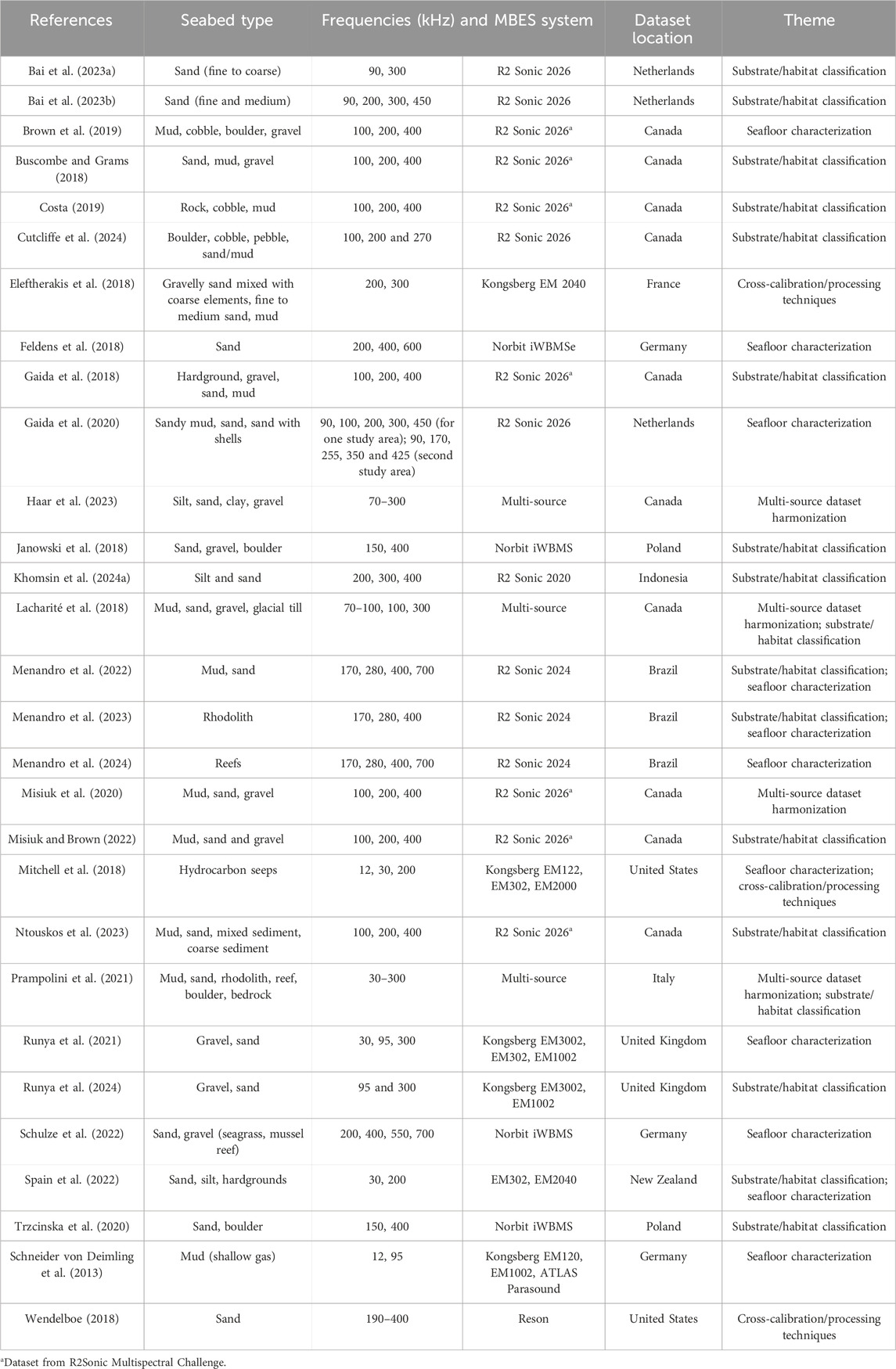
Table 1. Summary of references related to MBES multifrequency backscatter encountered in the scientific literature.
2 Methodology
To retrieve the relevant literature related to multifrequency MBES, a scientific literature review was conducted using multiple databases including Scopus, IEEE Xplore and Elsevier. Minor manual additions were made using Google Scholar. The search strings “multibeam backscatter multifrequency,” “multibeam multispectral backscatter” and “multibeam backscatter multiband” were used to retrieve relevant papers. No specific time cut-off was considered, given that the majority of the works are relatively recent in terms of the specific technology addressed. Relevant publications were then selected that i) were peer-reviewed; ii) were written in English; and iii) employed multifrequency acoustic MBES backscatter (e.g., not multispectral Lidar, Radar, or satellite images). We acknowledge the importance of technical reports, atlases, and books produced by government agencies and geological surveys around the globe, but in order to adhere to a procedure (see, for example, Atkinson et al., 2015), the focus was exclusively on peer-reviewed scientific papers. A wider search contemplating additional literature and non-English publications would provide a more complete overview, but such additional methodological effort is not suitable herein.
The search was concluded in November 2024, with a total of 29 articles retained for analysis. From these, we extracted information such as location of the survey, the sonar operating frequency, whether a single or multiple sonars were utilized, and the seabed type investigated. Finally, publications were categorized into four themes based on their focus: 1) substrate/habitat classification; 2) cross-calibration/processing techniques; 3) multi-source dataset harmonization; and 4) seafloor characterization. Some papers were assigned to more than one theme.
3 Results
Table 1 provides a comprehensive listing of all the 29 references related to MBES multispectral/multi-frequency backscatter identified and a summary of the information extracted.
The reviewed literature revealed that the majority of studies were conducted on substrates such as sand, mud, and gravel (Table 1), but that the multifrequency response of several other seafloor types have also been investigated including rhodolith beds (Menandro et al., 2023), reefs (Menandro et al., 2024), and hydrocarbon seeps (Mitchell et al., 2018). The majority of studies reviewed employed high frequencies (here considered >90 kHz), indicating a prevalence of shallow-water investigations, with few studies exploring deep-water applications with multiple lower frequencies–for example, 12–44 kHz (although see Mitchell et al., 2018).
The geographical distribution of the study sites represented in this review (Figure 1) indicates limited geographic coverage. Some nations that are active in the field of seabed mapping and classification using backscatter (e.g., Norway, Australia, China, Belgium) were not captured in this review due to a lack of published peer-reviewed literature to date–though a number of well-known conference publications exist (e.g., Hughes Clarke et al., 2008; Hughes Clarke, 2015). This is partly a function of the recent and continued emergence of the field.
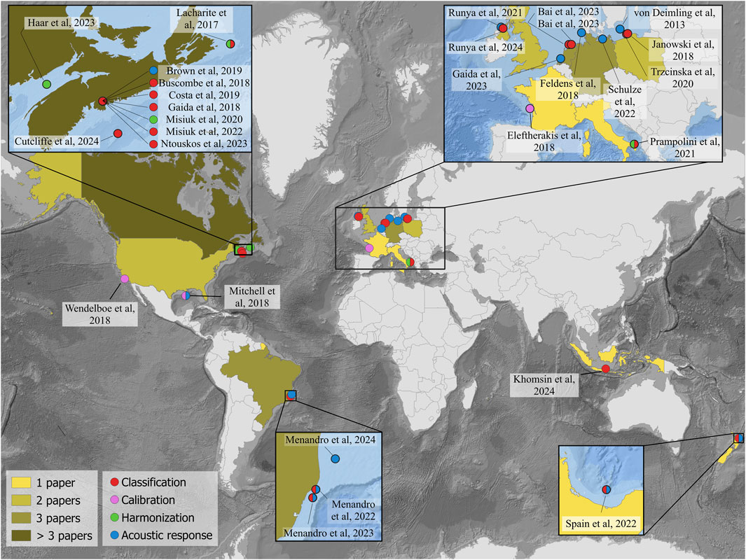
Figure 1. Geographical distribution of papers on multispectral backscatter until August 2024, classified according to main theme (substrate/habitat classification, cross-calibration/processing techniques, multi-source dataset harmonization, and seafloor characterization based on acoustic response).
The importance of the R2Sonic Multispectral Challenge datasets for stimulating multifrequency MBES research was evident from this review. Seven publications by different research groups returned from the literature search were associated with these datasets (Table 1). Data from other MBES systems such as Norbit (Kruss et al., 2023), Kongsberg, and Reson have also been analyzed in some cases, but there is a gap regarding comparison of different multifrequency and multi-source MBES systems operating in the same frequency range at the same site (e.g., Malik et al., 2019). Quality control, standardization, and calibration procedures for different systems and manufacturers have emerged as priority research questions in the field (Lecours et al., 2025).
Most of the publications reviewed relate to the theme of “substrate/habitat classification,” with 16 articles covering this topic (Table 1). Eleven papers focused on “seafloor characterization.” Only four and three papers address “multi-source dataset harmonization” and “cross-calibration/processing techniques,” respectively (Table 1). Studies related to the former were limited geographically to Canada and Italy; the latter occurred in France and the United States. While the paucity of work in these domains suggests the difficulty of utilizing multi-source datasets and attaining absolute backscatter values, it also indicates substantial scope for further exploration and extraction of useful information from legacy datasets.
4 Synthesis, prospects and challenges
A frequent conclusion of multifrequency backscatter analyses is that these datasets have enhanced our ability to characterize and classify the seabed from geological and biological perspectives. Brown et al. (2019), Costa (2019), and Menandro et al. (2022) highlight this for finer-grained sediments, and the benefits of multifrequency datasets have also been observed for other bottom types (Schulze et al., 2022; Spain et al., 2022). While higher frequencies are commonly useful for detailed mapping of surficial sediments (Mitchell et al., 2018; Janowski et al., 2018), lower frequencies may also be informative (Hughes Clarke, 2015; Feldens et al., 2018; Schneider von Deimling et al., 2013). In some cases, lower frequencies have even demonstrated greater ability to discriminate between sediment types (Gaida et al., 2018; Feldens et al., 2018). We note that, without a subsurface vehicle though (e.g., Mitchell et al., 2018), multifrequency applications are greatly limited in deeper waters by the ability of the signal to reach the bottom. Low frequencies (e.g., <30 kHz) are commonly used in such cases, yet these signals may easily penetrate metres into soft sediments (Mitchell, 1993; Schneider Von Deimling et al., 2013). Frequencies > 100 kHz are fully attenuated within 1 m of sediment, enabling their use for surficial multifrequency characterization, but limiting these applications to shallow waters. This is a technical limitation that is unlikely to be resolved for ship-borne mapping; the literature reviewed here thus primarily concerns high frequency sounding in shallower waters.
While the application of multiple frequencies does not always yield better distinction or classification results (see Runya et al., 2021; Menandro et al., 2023; Bai et al., 2023b; Runya et al., 2024), it may allow us to identify the most useful frequency to characterize a specific benthic environment that could be missed from a single frequency survey (Cutcliffe et al., 2024). Gaida et al. (2018) propose that a combination of 100 and 400 kHz yields comprehensive insights into seabed characteristics, yet the optimal frequency for acoustic-based classification is dependent on the specific characteristics of the local seabed. Runya et al. (2021) observed a stronger correlation between backscatter strength and mean grain size at 30 kHz than 300 kHz when examining a seafloor that ranged from sand to gravel. Bai et al. (2023b) did not observe this contrast at 90 and 300 kHz in study areas that were predominantly composed of sand. Menandro et al. (2023) observed that higher frequencies (280 and 400 kHz) exhibited enhanced sensitivity in detecting the presence of rhodoliths, but a lower frequency (170 kHz) proved more effective in characterizing abundance. Schulze et al. (2022) found that higher frequencies are optimal for discriminating coarse sand against gravel, while lower frequencies are susceptible to fluctuations in the shallow subsurface.
Limitations inherent to multifrequency surveys have also been previously identified. One such limitation is that the survey depth is constrained by the attenuation of the highest frequency. This can be overcome in some cases through the use of autonomous vehicles to obtain higher resolution data sets in the deep sea using higher operating frequencies (Mitchell et al., 2018). Additionally, the use of multiple frequencies may negatively impact resolution in the along-track direction when conducting a multifrequency survey on a ping-by-ping basis. Brown et al. (2019) configured the sampling rate of the sonar high enough to counter the along-track reduction in data density and did not observe any loss in the resolvability of seafloor features when compared against single frequency MBES backscatter mosaics. Another alternative technological solution to avoid reduction of along-track resolution when collecting multfrequency backscatter is the use of transmitted chirp signals and construction of multifrequency information on the receive signal (Trzcinska et al., 2021), although this technique provides fewer spectral bands compared to ping-by-ping modulation (e.g., Brown et al., 2019). Multifrequency data obtained using a single frequency over multiple passes presents difficulties related to the precise co-location of ensonification geometries and potential alterations in the seafloor over time (Montereale-Gavazzi et al., 2019). The use of single source multifrequency acquisition eliminates the potential issues associated with discrepancies in sonar configuration and survey geometry. Finally, MBES multifrequency surveys are limited to the lower frequency end by transducer design, wherein larger transducer arrays (up to several m in size) are necessary to operate below 20 kHz.
Some studies indicate that utilizing multifrequency data is non-trivial. In some cases, it is possible that the acoustic response of different acoustic frequencies depends on different sediment layers, which may display different backscattering due to signal penetration into the seafloor (Kohmsin et al., 2024b). Towards the outer beams, where the signal intersects the seabed at a higher incidence angle, it is increasingly difficult to separate the influences of surface and volume scattering. However, these challenges may offer an opportunity to investigate new metrics related to the relationships between frequencies (Misiuk and Brown, 2022). Schneider von Deimling et al. (2013) demonstrated that bathymetric measurements obtained at 12 kHz exhibited depth values that were systematically deeper by several meters in relation to those acquired at 95 kHz. Gaida et al. (2020) observed that the measured bathymetry and backscatter at different frequencies corresponded to different parts of the seabed. The authors argue that if the signal penetration and scattering (and unknown subsurface attenuation and refraction) from buried structures are not considered, multifrequency MBES data can also lead to ambiguous interpretations of the surficial seafloor.
Multisource legacy backscatter data represent a valuable resource for regional seabed mapping. However, the discrepancies associated with different sonar systems, frequencies, and software, have led to the development of approaches to synthesize and harmonize multiple datasets to meet management needs (Lacharité et al., 2018; Misiuk et al., 2020; Prampolini et al., 2021; Haar et al., 2023). Hughes Clarke et al. (2008) highlighted that these issues will persist in the compilation of seabed backscatter strength maps for an extended period, given the continuous upgrades of sonar systems. In this context, backscatter calibration studies also have potential to address and mitigate these inconsistencies, thereby facilitating the comparison of mosaics created from different acoustic sources. Backscatter calibration studies are still relatively scarce, even considering MBES single-frequency datasets (e.g., Fezzani et al., 2021), and have been incorporating a larger range of variables such as temperature (Van Dijk et al., 2024).
Technological development in the field of underwater acoustics has facilitated the investigation and enhancement of seabed classification techniques over the past few decades (Kenny et al., 2003; Robert et al., 2017; Strong et al., 2019; Misiuk and Brown, 2024). This has produced a range of tools based on diverse data sources and multidisciplinary approaches, which enables comprehensive geospatial modeling of seabed types and habitats. Methods for seabed classification using acoustic variables is still a very active field of research (Diaz et al., 2004; Brown et al., 2011; Lecours et al., 2016; Misiuk and Brown, 2024). Early approaches were interpretative, and technologies such as RoxAnn and QTC-View offered substantial advances through automated data-driven approaches (Hamilton et al., 1999; Foster-Smith et al., 2004; Brown et al., 2005). Recently advances have yielded increasingly robust and accurate models capable of supporting large data inputs, with MBES backscatter as a frequent component (Stephens and Diesing, 2014; Trzcinska et al., 2020; Cui et al., 2021; Misiuk and Brown, 2022; Garone et al., 2023). In addition to the development of approaches utilising mosaics or angular responses, multifrequency backscatter data has enabled analyses of the multifrequency response of the seafloor based on the creation of multiband false color mosaics, similar to those employed in satellite remote sensing. While distinct patterns in such datasets have been observed in some instances (Feldens et al., 2018; Schulze et al., 2022; Menandro et al., 2022), their meaning is generally not fully understood.
While novel technologies have enabled the acquisition of larger datasets (at higher resolutions and often including water column backscatter data) increasing data volumes have also introduced analytical challenges. Very large data volumes from modern MBES systems now require methods for extracting and summarising information in an efficient and meaningful way. This issue is compounded when the expansive selection of potential textural, angular response, composite, depth, and morphometric features are considered–each of which may be considered in multiples when utilizing multifrequency data. We believe that deep neural network approaches have great potential to optimize the analysis of such multi-dimensional and multivariate MBES datasets (Misiuk et al., 2021; Arosio et al., 2023; Garone et al., 2023), providing an opportunity to efficiently explore geospatial modelling by employing a deep convolutional architecture.
The work reviewed here suggests that continued improvements to multifrequency MBES technologies and techniques have great potential to provide better characterization of both surficial and sub-surface seafloor attributes (Figure 2). The application of multifrequency backscatter can support a number of critical topics that are aligned with international priorities such as the UN Decade of Ocean Science, including site characterization for offshore wind farms, habitat mapping for conservation and management, identification of fluid mud in ports, natural resource mapping, and marine spatial planning. Multifrequency backscatter may support these initiatives through textural sediment characterization (Runya et al., 2021; Menandro et al., 2022; Misiuk and Brown, 2022); investigations of the seabed subsurface (Schneider von Deimling et al., 2013; Gaida et al., 2020); mapping of biotic features and habitats (Feldens et al., 2018; Bai et al., 2023b; Runya et al., 2024; Cutcliffe et al., 2024); rough and hardbottom characterization (Menandro et al., 2023; Menandro et al., 2024); macroalgae mapping (Schimel et al., 2020; Menandro et al., 2024); water column applications (Spain et al., 2022; Guedes et al., 2024); and deep sea mapping with remote vehicles (e.g., Mitchell et al., 2018; Gazis et al., 2024). In the future, it may even be feasible to catalog and link multifrequency patterns to specific habitats or even individual species, similar to approaches used in multispectral satellite remote sensing.
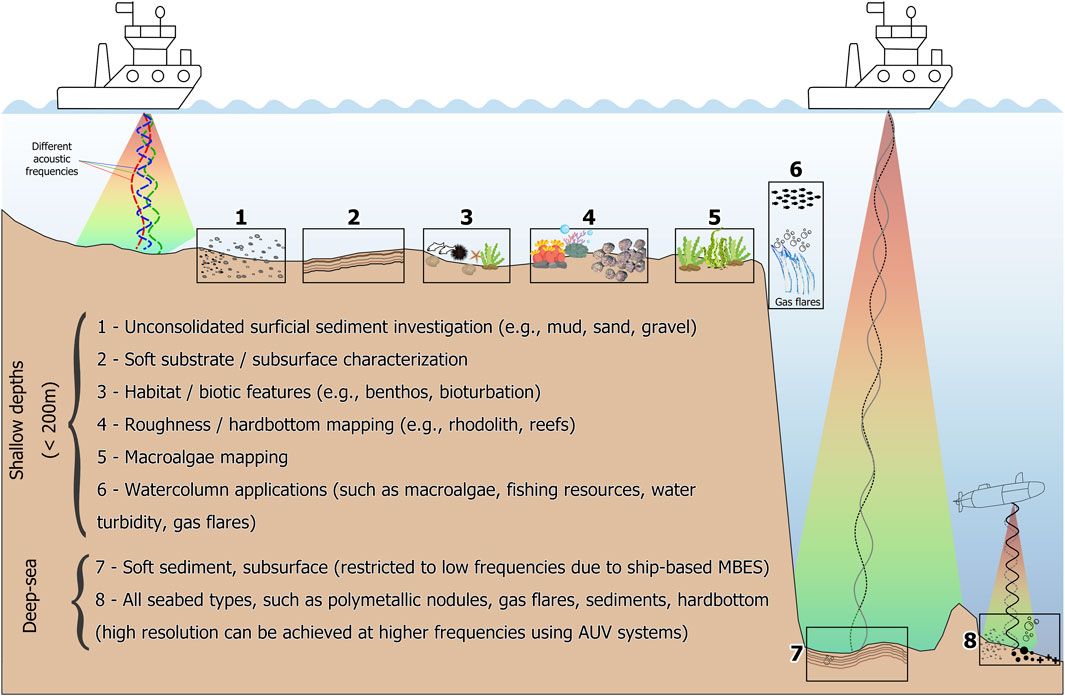
Figure 2. Multifrequency backscatter may enable better characterization of certain substrates and features across different benthic environments (1-6 shallow environments, 7-8 deep-sea environments). Currently, most multifrequency backscatter research is confined to shallow water (<200 m).
Author contributions
PM: Conceptualization, Formal Analysis, Methodology, Writing–original draft. BM: Conceptualization, Formal Analysis, Writing–review and editing. JS: Conceptualization, Writing–review and editing. AB: Conceptualization, Writing–review and editing. CB: Conceptualization, Funding acquisition, Writing–review and editing.
Funding
The author(s) declare that financial support was received for the research, authorship, and/or publication of this article. Funding was provided by the Ocean Frontier Institute, through an award from the Canada First Research Excellence Fund.
Acknowledgments
This research is part of Benthic Ecosystem Mapping and Engagement (BEcoME) Project (www.ofibecome.org), and Fapes-Pronex/Geomar.
Conflict of interest
The authors declare that the research was conducted in the absence of any commercial or financial relationships that could be construed as a potential conflict of interest.
The author(s) declared that they were an editorial board member of Frontiers, at the time of submission. This had no impact on the peer review process and the final decision.
Generative AI statement
The author(s) declare that no Generative AI was used in the creation of this manuscript.
Publisher’s note
All claims expressed in this article are solely those of the authors and do not necessarily represent those of their affiliated organizations, or those of the publisher, the editors and the reviewers. Any product that may be evaluated in this article, or claim that may be made by its manufacturer, is not guaranteed or endorsed by the publisher.
References
Arosio, R., Hobley, B., Wheeler, A. J., Sacchetti, F., Conti, L. A., Furey, T., et al. (2023). Fully convolutional neural networks applied to large-scale marine morphology mapping. Front. Mar. Sci. 10, 1228867. doi:10.3389/fmars.2023.1228867
Atkinson, K. M., Koenka, A. C., Sanchez, C. E., Moshontz, H., and Cooper, H. (2015). Reporting standards for literature searches and report inclusion criteria: making research syntheses more transparent and easy to replicate. Res. Synthesis Methods 6, 87–95. doi:10.1002/jrsm.1127
Bai, Q., Mestdagh, S., Snellen, M., and Amiri-Simkooei, A. (2023a). Characterizing seabed sediments using multi-spectral backscatter data in the North Sea. OCEANS 2023 - Limerick, 1–7. doi:10.1109/OCEANSLimerick52467.2023.10244650
Bai, Q., Mestdagh, S., Snellen, M., and Simons, D. G. (2023b). Indications of marine benthos occurrence from multi-spectral multi-beam backscatter data: a case study in the North Sea. Front. Earth Sci. 11, 1140649. doi:10.3389/feart.2023.1140649
Brown, C., Beaudoin, J., Brissette, M., and Gazzola, V. (2019). Multispectral multibeam echo sounder backscatter as a tool for improved seafloor characterization. Geosciences 9 (3), 126. doi:10.3390/geosciences9030126
Brown, C. J., Mitchell, A., Limpenny, D. S., Robertson, M. R., Service, M., and Golding, N. (2005). Mapping seabed habitats in the Firth of Lorn off the west coast of Scotland: evaluation and comparison of habitat maps produced using the acoustic ground-discrimination system, RoxAnn, and sidescan sonar. ICES J. Mar. Sci. 62 (4), 790–802. doi:10.1016/j.icesjms.2004.10.008
Brown, C. J., Schimel, A., and Roche, M. (2022). Multibeam sonar backscatter workshop (backscatter working group – BSWG II). Zenodo. doi:10.5281/ZENODO.10980406
Brown, C. J., Smith, S. J., Lawton, P., and Anderson, J. T. (2011). Benthic habitat mapping: a review of progress towards improved understanding of the spatial ecology of the seafloor using acoustic techniques. Estuar. Coast. Shelf Sci. 92 (3), 502–520. doi:10.1016/j.ecss.2011.02.007
Buscombe, D., and Grams, P. E. (2018). Probabilistic substrate classification with multispectral acoustic backscatter: a comparison of discriminative and generative models. Geosciences 8 (11), 395. doi:10.3390/geosciences8110395
Chakraborty, B., Schenke, H. W., Kodagali, V., and Hagen, R. (2000). Seabottom characterization using multibeam echosounder angular backscatter: an application of the composite roughness theory. IEEE Trans. Geoscience Remote Sens. 38 (5), 2419–2422. doi:10.1109/36.868896
Che Hasan, R., Ierodiaconou, D., Laurenson, L., and Schimel, A. (2014). Integrating multibeam backscatter angular response, mosaic and bathymetry data for benthic habitat mapping. PLoS ONE 9 (5), e97339. doi:10.1371/journal.pone.0097339
Chesterman, W. D., Clynick, P. R., and Stride, A. H. (1958). An acoustic aid to sea bed survey. Acustica 8, 185–290.
Clay, C. S., Ess, J., and Weisman, I. (1964). Lateral echo sounding of the ocean bottom on the continental rise. J. Geophys. Res. 69 (18), 3823–3835. doi:10.1029/JZ069i018p03823
Costa, B. (2019). Multispectral acoustic backscatter: how useful is it for marine habitat mapping and management? J. Coast. Res. 35 (5), 1062. doi:10.2112/JCOASTRES-D-18-00103.1
Cui, X., Yang, F., Wang, X., Ai, B., Luo, Y., and Ma, D. (2021). Deep learning model for seabed sediment classification based on fuzzy ranking feature optimization. Mar. Geol. 432, 106390. doi:10.1016/j.margeo.2020.106390
Cutcliffe, S., Misiuk, B., Porskamp, P., Robert, K., Murillo, F. J., and Brown, C. J. (2024). Benthic habitat mapping of the glass sponge (Vazella pourtalesii), and associated community composition on Sambro Bank, Scotian Shelf, Canada. Can. J. Fish. Aquatic Sci. 82, 1–14. doi:10.1139/cjfas-2023-0378
Cutter, G. R., and Demer, D. A. (2014). Seabed classification using surface backscattering strength versus acoustic frequency and incidence angle measured with vertical, split-beam echosounder. ICES J. Mar. Sci. 71 (4), 882–894. doi:10.1093/icesjms/fst177
de Moustier, C. (1986). Beyond bathymetry: mapping acoustic backscattering from the deep seafloor with sea beam. J. Acoust. Soc. Am. 79, 316–331. doi:10.1121/1.393570
Diaz, R. J., Solan, M., and Valente, R. M. (2004). A review of approaches for classifying benthic habitats and evaluating habitat quality. J. Environ. Manag. 73 (3), 165–181. doi:10.1016/j.jenvman.2004.06.004
Diesing, M., Mitchell, P., and Stephens, D. (2016). Image-based seabed classification: what can we learn from terrestrial remote sensing? ICES J. Mar. Sci. J. Du Conseil 73 (10), 2425–2441. doi:10.1093/icesjms/fsw118
Dolan, M. F. J., Bøe, R., and Bjarnadóttir, L. R. (2022). Delivering seabed geodiversity information through multidisciplinary mapping initiatives: experiences from Norway. GEUS Bull. 52. doi:10.34194/geusb.v52.8325
Eleftherakis, D., Berger, L., Le Bouffant, N., Pacault, A., Augustin, J.-M., and Lurton, X. (2018). Backscatter calibration of high-frequency multibeam echosounder using a reference single-beam system, on natural seafloor. Mar. Geophys. Res. 39 (1–2), 55–73. doi:10.1007/s11001-018-9348-5
Fakiris, E., Blondel, P., Papatheodorou, G., Christodoulou, D., Dimas, X., Georgiou, N., et al. (2019). Multi-frequency, multi-sonar mapping of shallow habitats—efficacy and management implications in the national marine park of zakynthos, Greece. Remote Sens. 11 (4), 461. doi:10.3390/rs11040461
Feldens, P., Schulze, I., Papenmeier, S., Schönke, M., and Schneider Von Deimling, J. (2018). Improved interpretation of marine sedimentary environments using multi-frequency multibeam backscatter data. Geosciences 8 (6), 214. doi:10.3390/geosciences8060214
Fezzani, R., Berger, L., Le Bouffant, N., Fonseca, L., and Lurton, X. (2021). Multispectral and multiangle measurements of acoustic seabed backscatter acquired with a tilted calibrated echosounder. J. Acoust. Soc. Am. 149 (6), 4503–4515. doi:10.1121/10.0005428
Fonseca, L., and Mayer, L. (2007). Remote estimation of surficial seafloor properties through the application Angular Range Analysis to multibeam sonar data. Mar. Geophys. Res. 28 (2), 119–126. doi:10.1007/s11001-007-9019-4
Foster-Smith, R. L., Brown, C. J., Meadows, W. J., White, W. H., and Limpenny, D. S. (2004). Mapping seabed biotopes at two spatial scales in the eastern English Channel. Part 2. Comparison of two acoustic ground discrimination systems. J. Mar. Biol. Assoc. U. K. 84 (3), 489–500. doi:10.1017/S0025315404009506h
Gaida, T. C., Mohammadloo, T. H., Snellen, M., and Simons, D. G. (2020). Mapping the seabed and shallow subsurface with multi-frequency multibeam echosounders. Remote Sens. 12 (1), 52. doi:10.3390/rs12010052
Gaida, T. C., Tengku Ali, T. A., Snellen, M., Amiri-Simkooei, A., Van Dijk, T. A. G. P., and Simons, D. G. (2018). A multispectral bayesian classification method for increased acoustic discrimination of seabed sediments using multi-frequency multibeam backscatter data. Geosciences 8 (12), 455. doi:10.3390/geosciences8120455
Garone, R. V., Birkenes Lønmo, T. I., Schimel, A. C. G., Diesing, M., Thorsnes, T., and Løvstakken, L. (2023). Seabed classification of multibeam echosounder data into bedrock/non-bedrock using deep learning. Front. Earth Sci. 11, 1285368. doi:10.3389/feart.2023.1285368
Gazis, I.-Z., Charlet, F., and Greinert, J. (2024). An interpretable multi-model machine learning approach for spatial mapping of deep-sea polymetallic nodule occurrences. Nat. Resour. Res. 33, 2473–2501. doi:10.1007/s11053-024-10393-7
Guedes, P. A., Silva, H., Wang, S., Martins, A., Almeida, J. M., and Silva, E. (2024). Multibeam multi-frequency characterization of water column litter. OCEANS 2024 - Singap., 1–6. doi:10.1109/OCEANS51537.2024.10682168
Haar, C., Misiuk, B., Gazzola, V., Wells, M., and Brown, C. J. (2023). Harmonizing multi-source backscatter data using bulk shift approaches to generate regional seabed maps: bay of Fundy, Canada. J. Maps 19 (1), 2223629. doi:10.1080/17445647.2023.2223629
Hamilton, L. J., Mulhearn, P. J., and Poeckert, R. (1999). Comparison of RoxAnn and QTC-View acoustic bottom classification system performance for the Cairns area, Great Barrier Reef, Australia. Cont. Shelf Res. 19 (12), 1577–1597. doi:10.1016/S0278-4343(99)00020-5
Hamouda, A. Z., Fekry, A., and El-Gharabawy, S. (2024). Acoustic-based classification of marine geophysical data for benthic habitat mapping in the littoral zone of Qaitbay Citadel of Alexandria. Egypt. J. Aquatic Res. 50 (1), 8–16. doi:10.1016/j.ejar.2024.02.004
Haris, K., Chakraborty, B., De, C., Prabhudesai, R. G., and Fernandes, W. (2011). Model-based seafloor characterization employing multi-beam angular backscatter data—a comparative study with dual-frequency single beam. J. Acoust. Soc. Am. 130 (6), 3623–3632. doi:10.1121/1.3658454
Harris, P. T., and Baker, E. (2020). Seafloor geomorphology as benthic habitat: GeoHAB atlas of seafloor geomorphic features and benthic habitats. 2nd ed. Elsevier.
Harris, P. T., and Baker, E. K. (2012). “GeoHab atlas of seafloor geomorphic features and benthic habitats,” in Seafloor geomorphology as benthic habitat (Elsevier), 871–890.
Hughes Clarke, J. E. (2015). “Multispectral acoustic backscatter from multibeam,” in Improved classification potential. 19. Maryland: U.S. Hydrographic Conference.
Hughes Clarke, J. E. H., Iwanowska, K. K., Parrott, R., Duffy, G., Lamplugh, M., and Griffin, J. (2008). “Inter-calibrating multi-source, multi-platform backscatter data sets to assist in compiling regional sediment type maps: bay of Fundy,” in Conference: CHC2008CHC2008.
Ierodiaconou, D., Schimel, A. C. G., Kennedy, D., Monk, J., Gaylard, G., Young, M., et al. (2018). Combining pixel and object based image analysis of ultra-high resolution multibeam bathymetry and backscatter for habitat mapping in shallow marine waters. Mar. Geophys. Res. 39 (1–2), 271–288. doi:10.1007/s11001-017-9338-z
Jackson, D. R., Winebrenner, D. P., and Ishimaru, A. (1986). Application of the composite roughness model to high-frequency bottom backscattering. J. Acoust. Soc. Am. 79 (5), 1410–1422. doi:10.1121/1.393669
Janowski, L., Trzcinska, K., Tegowski, J., Kruss, A., Rucinska-Zjadacz, M., and Pocwiardowski, P. (2018). Nearshore benthic habitat mapping based on multi-frequency, multibeam echosounder data using a combined object-based approach: a case study from the rowy site in the southern baltic sea. Remote Sens. 10 (12), 1983. doi:10.3390/rs10121983
Kargl, S. G., Williams, K. L., Marston, T. M., Kennedy, J. L., and Lopes, J. L. (2010). Acoustic response of unexploded ordnance (UXO) and cylindrical targets. OCEANS 2010 MTS/IEEE SEATTLE, 1–5. doi:10.1109/OCEANS.2010.5664392
Kenny, A. J., Cato, I., Desprez, M., Fader, G., Schüttenhelm, R. T. E., and Side, J. (2003). An overview of seabed-mapping technologies in the context of marine habitat classification. ICES J. Mar. Sci. 60 (2), 411–418. doi:10.1016/S1054-3139(03)00006-7
Khomsin, M., Suntoyo, P., and Hudaya, (2024a). Seabed sediment classification through multispectral backscatter mosaic MBES and angular response analysis. J. Hunan Univ. Nat. Sci. 51 (5). doi:10.55463/issn.1674-2974.51.5.12
Khomsin, M., Suntoyo, P., and Hudaya, A. I. (2024b). Bathymetry and bathymetric differences MBES multifrequency for seafloor sediment mapping. Int. J. GEOMATE 26 (115). doi:10.21660/2024.115.4131
Knott, S. T., and Hersey, J. B. (1957). Interpretation of high-resolution echo-sounding techniques and their use in bathymetry, marine geophysics, and biology. Deep Sea Res. 4, 36–44. doi:10.1016/0146-6313(56)90030-2
Korneliussen, R. J., Diner, N., Ona, E., Berger, L., and Fernandes, P. G. (2008). Proposals for the collection of multifrequency acoustic data. ICES J. Mar. Sci. 65 (6), 982–994. doi:10.1093/icesjms/fsn052
Kruss, A., Rucinska, M., Grzadziel, A., Waz, M., and Pocwiardowski, P. (2023). Multi-band, calibrated backscatter from high frequency multibeam systems as an efficient tool for seabed monitoring. 2023 IEEE Underw. Technol. Ut., 1–5. doi:10.1109/UT49729.2023.10103390
Lacharité, M., Brown, C. J., and Gazzola, V. (2018). Multisource multibeam backscatter data: developing a strategy for the production of benthic habitat maps using semi-automated seafloor classification methods. Mar. Geophys. Res. 39 (1–2), 307–322. doi:10.1007/s11001-017-9331-6
Lamarche, G., Lurton, X., Verdier, A.-L., and Augustin, J.-M. (2011). Quantitative characterisation of seafloor substrate and bedforms using advanced processing of multibeam backscatter—application to Cook Strait, New Zealand. Cont. Shelf Res. 31 (2), S93–S109. doi:10.1016/j.csr.2010.06.001
Lecours, V., Dolan, M. F. J., Micallef, A., and Lucieer, V. L. (2016). A review of marine geomorphometry, the quantitative study of the seafloor. Hydrology Earth Syst. Sci. 20 (8), 3207–3244. doi:10.5194/hess-20-3207-2016
Lecours, V., Misiuk, B., Butschek, F., Blondel, P., Montereale-Gavazzi, G., Lucieer, V. L., et al. (2025). Identifying community-driven priority questions in acoustic backscatter research. Front. Remote Sens. 5, 1484283. doi:10.3389/frsen.2024.1484283
Lurton, X., Lamarche, G., Brown, C., Lucieer, V., Rice, G., Schimel, A., et al. (2015). Backscatter measurements by seafloor-mapping sonars. Guidelines Recom. (Version 1.0). doi:10.5281/ZENODO.10089261
Luskin, B., Heezen, B. C., Ewing, M., and Landisman, M. (1954). Precision measurement of ocean depth. Deep Sea Res. 1 (3), 131–IN8. doi:10.1016/0146-6313(54)90044-1
Malik, M., Schimel, A. C. G., Masetti, G., Roche, M., Le Deunf, J., Dolan, M. F. J., et al. (2019). Results from the first phase of the seafloor backscatter processing software inter-comparison Project. Geosciences 9 (12), 516. doi:10.3390/geosciences9120516
McKinney, C. M., and Anderson, C. D. (1964). Measurements of backscattering of sound from the Ocean bottom. J. Acoust. Soc. Am. 36 (1), 158–163. doi:10.1121/1.1918927
Menandro, P. S., and Bastos, A. C. (2020). Seabed mapping: a brief history from meaningful words. Geosciences 10 (7), 273. doi:10.3390/geosciences10070273
Menandro, P. S., Bastos, A. C., Misiuk, B., and Brown, C. J. (2022). Applying a multi-method framework to analyze the multispectral acoustic response of the seafloor. Front. Remote Sens. 3, 860282. doi:10.3389/frsen.2022.860282
Menandro, P. S., Misiuk, B., Brown, C. J., and Bastos, A. C. (2023). Multispectral multibeam backscatter response of heterogeneous rhodolith beds. Sci. Rep. 13 (1), 20220. doi:10.1038/s41598-023-46240-7
Menandro, P. S., Vieira, F. V., Bastos, A. C., and Brown, C. J. (2024). Exploring the multispectral acoustic response of reef habitats. Front. Remote Sens. 5, 1490741. doi:10.3389/frsen.2024.1490741
Misiuk, B., and Brown, C. J. (2022). Multiple imputation of multibeam angular response data for high resolution full coverage seabed mapping. Mar. Geophys. Res. 43 (1), 7. doi:10.1007/s11001-022-09471-3
Misiuk, B., and Brown, C. J. (2024). Benthic habitat mapping: a review of three decades of mapping biological patterns on the seafloor. Estuar. Coast. Shelf Sci. 296, 108599. doi:10.1016/j.ecss.2023.108599
Misiuk, B., Brown, C. J., Robert, K., and Lacharité, M. (2020). Harmonizing multi-source sonar backscatter datasets for seabed mapping using bulk shift approaches. Remote Sens. 12 (4), 601. doi:10.3390/rs12040601
Misiuk, B., Lecours, V., Dolan, M. F. J., and Robert, K. (2021). Evaluating the suitability of multi-scale terrain attribute calculation approaches for seabed mapping applications. Mar. Geod. 44 (4), 327–385. doi:10.1080/01490419.2021.1925789
Misiuk, B., Tan, Y. L., Li, M. Z., Trappenberg, T., Alleosfour, A., Church, I. W., et al. (2024). Multivariate mapping of seabed grain size parameters in the Bay of Fundy using convolutional neural networks. Mar. Geol. 472, 107299. doi:10.1016/j.margeo.2024.107299
Mitchell, G. A., Orange, D. L., Gharib, J. J., and Kennedy, P. (2018). Improved detection and mapping of deepwater hydrocarbon seeps: optimizing multibeam echosounder seafloor backscatter acquisition and processing techniques. Mar. Geophys. Res. 39 (1–2), 323–347. doi:10.1007/s11001-018-9345-8
Mitchell, N. C. (1993). A model for attenuation of backscatter due to sediment accumulations and its application to determine sediment thicknesses with GLORIA sidescan sonar. J. Geophys. Res. Solid Earth 98 (B12), 22477–22493. doi:10.1029/93JB02217
Montereale-Gavazzi, G., Roche, M., Degrendele, K., Lurton, X., Terseleer, N., Baeye, M., et al. (2019). Insights into the short-term tidal variability of multibeam backscatter from field experiments on different seafloor types. Geosciences 9 (1), 34. doi:10.3390/geosciences9010034
Nafe, J. E., and Drake, C. L. (1961). Physical properties of marine sediments. Marine Geochem. doi:10.7916/D8-3ZP6-4263
Nemani, S., Cote, D., Misiuk, B., Edinger, E., Mackin-McLaughlin, J., Templeton, A., et al. (2022). A multi-scale feature selection approach for predicting benthic assemblages. Estuar. Coast. Shelf Sci. 277, 108053. doi:10.1016/j.ecss.2022.108053
Ntouskos, V., Mertikas, P., Mallios, A., and Karantzalos, K. (2023). Seabed classification from multispectral multibeam data. IEEE J. Ocean. Eng. 48 (3), 874–887. doi:10.1109/JOE.2023.3267795
Porskamp, P., Young, M., Rattray, A., Brown, C. J., Hasan, R. C., and Ierodiaconou, D. (2022). Integrating angular backscatter response analysis derivatives into a hierarchical classification for habitat mapping. Front. Remote Sens. 3, 903133. doi:10.3389/frsen.2022.903133
Prampolini, M., Angeletti, L., Castellan, G., Grande, V., Le Bas, T., Taviani, M., et al. (2021). Benthic habitat map of the southern adriatic sea (mediterranean sea) from object-based image analysis of multi-source acoustic backscatter data. Remote Sens. 13 (15), 2913. doi:10.3390/rs13152913
Robert, K., Huvenne, V. A. I., Georgiopoulou, A., Jones, D. O. B., Marsh, L., Carter, G., et al. (2017). New approaches to high-resolution mapping of marine vertical structures. Sci. Rep. 7 (1), 9005. doi:10.1038/s41598-017-09382-z
Runya, R. M., McGonigle, C., Quinn, R., and Callaway, A. (2024). Spatial distribution of sandeel (Hyperoplus lanceolatus) and implications for monitoring marine protected sites. Mar. Environ. Res. 201, 106706. doi:10.1016/j.marenvres.2024.106706
Runya, R. M., McGonigle, C., Quinn, R., Howe, J., Collier, J., Fox, C., et al. (2021). Examining the links between multi-frequency multibeam backscatter data and sediment grain size. Remote Sens. 13 (8), 1539. doi:10.3390/rs13081539
Ryabinin, V., Barbière, J., Haugan, P., Kullenberg, G., Smith, N., McLean, C., et al. (2019). The UN decade of Ocean Science for sustainable development. Front. Mar. Sci. 6, 470. doi:10.3389/fmars.2019.00470
Ryan, W. B. F., and Flood, R. D. (1996). Side-looking sonar backscatter response at dual frequencies. Mar. Geophys. Res. 18 (6), 689–705. doi:10.1007/BF00313881
Rymansaib, Z., Hunter, A., Bowen, C., Dillon, J., Charron, R., and Shea, D. (2019). “Preliminary target measurements from a prototype multispectral synthetic aperture sonar,” in Underwater acoustics conference and exhibition series, crete, Greece.
Schimel, A. C. G., Brown, C. J., and Ierodiaconou, D. (2020). Automated filtering of multibeam water-column data to detect relative abundance of giant kelp (macrocystis pyrifera). Remote Sens. 12 (9), 1371. doi:10.3390/rs12091371
Schneider Von Deimling, J., Weinrebe, W., Tóth, Zs., Fossing, H., Endler, R., Rehder, G., et al. (2013). A low frequency multibeam assessment: spatial mapping of shallow gas by enhanced penetration and angular response anomaly. Mar. Petroleum Geol. 44, 217–222. doi:10.1016/j.marpetgeo.2013.02.013
Schrodt, F., Bailey, J. J., Kissling, W. D., Rijsdijk, K. F., Seijmonsbergen, A. C., Van Ree, D., et al. (2019). To advance sustainable stewardship, we must document not only biodiversity but geodiversity. Proc. Natl. Acad. Sci. 116 (33), 16155–16158. doi:10.1073/pnas.1911799116
Schulze, I., Gogina, M., Schönke, M., Zettler, M. L., and Feldens, P. (2022). Seasonal change of multifrequency backscatter in three Baltic Sea habitats. Front. Remote Sens. 3, 956994. doi:10.3389/frsen.2022.956994
Simons, D. G., and Snellen, M. (2009). A Bayesian approach to seafloor classification using multi-beam echo-sounder backscatter data. Appl. Acoust. 70 (10), 1258–1268. doi:10.1016/j.apacoust.2008.07.013
Spain, E., Lamarche, G., Lucieer, V., Watson, S. J., Ladroit, Y., Heffron, E., et al. (2022). Acoustic predictors of active fluid expulsion from a hydrothermal vent field, offshore taupō volcanic zone, New Zealand. Front. Earth Sci. 9, 785396. doi:10.3389/feart.2021.785396
Stephens, D., and Diesing, M. (2014). A comparison of supervised classification methods for the prediction of substrate type using multibeam acoustic and legacy grain-size data. PLoS ONE 9 (4), e93950. doi:10.1371/journal.pone.0093950
Strong, J. A., Clements, A., Lillis, H., Galparsoro, I., Bildstein, T., and Pesch, R. (2019). A review of the influence of marine habitat classification schemes on mapping studies: inherent assumptions, influence on end products, and suggestions for future developments. ICES J. Mar. Sci. 76 (1), 10–22. doi:10.1093/icesjms/fsy161
Tamsett, D., McIlvenny, J., and Watts, A. (2016). Colour sonar: multi-frequency sidescan sonar images of the seabed in the inner sound of the pentland firth, scotland. J. Mar. Sci. Eng. 4 (1), 26. doi:10.3390/jmse4010026
Trzcinska, K., Janowski, L., Nowak, J., Rucinska-Zjadacz, M., Kruss, A., Von Deimling, J. S., et al. (2020). Spectral features of dual-frequency multibeam echosounder data for benthic habitat mapping. Mar. Geol. 427, 106239. doi:10.1016/j.margeo.2020.106239
Trzcinska, K., Tegowski, J., Pocwiardowski, P., Janowski, L., Zdroik, J., Kruss, A., et al. (2021). Measurement of seafloor acoustic backscatter angular dependence at 150 kHz using a multibeam echosounder. Remote Sens. 13 (23), 4771. doi:10.3390/rs13234771
Urick, R. J. (1954). The backscattering of sound from a harbor bottom. J. Acoust. Soc. Am. 26 (2), 231–235. doi:10.1121/1.1907314
Van Dijk, T. A. G. P., Roche, M., Lurton, X., Fezzani, R., Simmons, S. M., Gastauer, S., et al. (2024). Bottom and suspended sediment backscatter measurements in a flume—towards quantitative bed and water column properties. J. Mar. Sci. Eng. 12 (4), 609. doi:10.3390/jmse12040609
Weber, T. C., and Ward, L. G. (2015). Observations of backscatter from sand and gravel seafloors between 170 and 250 kHz. J. Acoust. Soc. Am. 138 (4), 2169–2180. doi:10.1121/1.4930185
Wendelboe, G. (2018). Backscattering from a sandy seabed measured by a calibrated multibeam echosounder in the 190–400 kHz frequency range. Mar. Geophys. Res. 39 (1–2), 105–120. doi:10.1007/s11001-018-9350-y
Williams, K. L., Jackson, D. R., Dajun, T., Briggs, K. B., and Thorsos, E. I. (2009). Acoustic backscattering from a sand and a sand/mud environment: experiments and data/model comparisons. IEEE J. Ocean. Eng. 34 (4), 388–398. doi:10.1109/JOE.2009.2018335
Keywords: multifrequency backscatter, seafloor mapping, multispectral, multibeam echosounder, benthic habitat mapping
Citation: Menandro PS, Misiuk B, Schneider von Deimling J, Bastos AC and Brown CJ (2025) Multifrequency seafloor acoustic backscatter as a tool for improved biological and geological assessments – updating knowledge, prospects, and challenges. Front. Remote Sens. 6:1546280. doi: 10.3389/frsen.2025.1546280
Received: 16 December 2024; Accepted: 19 February 2025;
Published: 05 March 2025.
Edited by:
DelWayne Roger Bohnenstiehl, North Carolina State University, United StatesReviewed by:
Robert Mzungu Runya, Marine Institute, IrelandCopyright © 2025 Menandro, Misiuk, Schneider von Deimling, Bastos and Brown. This is an open-access article distributed under the terms of the Creative Commons Attribution License (CC BY). The use, distribution or reproduction in other forums is permitted, provided the original author(s) and the copyright owner(s) are credited and that the original publication in this journal is cited, in accordance with accepted academic practice. No use, distribution or reproduction is permitted which does not comply with these terms.
*Correspondence: Pedro S. Menandro, cGVkcm8ubWVuYW5kcm9AZGFsLmNh