 Degefie Tibebe
 Ermias Teferi
 Woldeamlak Bewket1,3
- 1Water and Land Resource Center, Addis Ababa University, Addis Ababa, Ethiopia
- 2Center for Environment and Development, Addis Ababa University, Addis Ababa, Ethiopia
- 3Department of Geography and Environmental Studies, Addis Ababa University, Addis Ababa, Ethiopia
Climate induced water security risks on agriculture are assessed in the Abbay river basin by reviewing journal articles, book chapters and research reports. The intent of the review is to understand the state of water security issues in the agricultural sector in relation to climate variability and climate change, existing agricultural water management practices and identification of gaps in knowledge and practices that need to be addressed in the future. It is found that the basin has huge potential of water resources but it is constrained by high spatiotemporal climate variability which has resulted in very variable water supply for agriculture. The challenge is aggravated by lack of effective and locally relevant agricultural water management practices. The central part of the basin in particular is characterized by very short rainy season and long dry season and thus it is the main hotspot of water security risks to agriculture. Climate change, growing demand for water due to increasing population, and land degradation will exacerbate water security risks on agriculture. Research and development efforts to addressing the challenges have generally been limited in scope and spatial scale, so much remains to be done. This review identifies major gaps that need to be investigated and understood in the future to address water security issues on agriculture in the basin.
Introduction
Water resource management has received renewed international policy attention with the global agreement on Agenda 2030, or the sustainable development goals (SDGs). A key factor for improving water resource management is improved understanding of quantity and quality of water at different spatial scales of water management and its variability with time (Loucks and van Beek, 2017). Water availability varies both spatially and temporally largely because of the natural variability of climate that controls hydrological regimes and the disruptive interference of human activities in the natural functioning of water catchments as well as causing the global climate change. Climate change is a global phenomenon, but its adverse effects are local specific, thus requiring context specific adaptation planning. From the climate perspective, addressing water security issues requires understanding of climate variability and climate change at different spatial and temporal scales and its multifaceted implications on water resources, so as to identify locally relevant solutions.
The Abbay river basin, which is the most important source of water to the Nile river, is characterized by large seasonal and inter-annual hydro-climatic variability predominantly influenced by varying altitude and latitude (BCEOM, 1998; Conway, 2000; Tekleab et al., 2014). Climate change is causing additional stress on water availability in the basin through increased evaporation losses as a result of rising air temperatures and intense precipitation in some parts leading to flash floods. In some other parts, reduction in rainfall is leading to severe drought and low flow conditions during dry seasons. On the other hand, the demand for water for various uses is growing rapidly (Kim et al., 2008; McCartney et al., 2012, 2013; Gelete et al., 2020).
Several studies have been conducted over years on climate and water resources of the Nile river basin region in general and the Abbay basin in particular (Conway, 2000, 2005; Osman et al., 2000; NMA, 2001, 2007; Conway et al., 2004; Seleshi and Zanke, 2004; Verdin et al., 2005; Bewket and Conway, 2007; Cheung et al., 2008; Abtew et al., 2009; McSweeney et al., 2009; ACCRA, 2012; Ayalew et al., 2012; Tesso et al., 2012; Viste et al., 2012; Jury and Funk, 2013). There are also many researches exploring water management issues and options in the context of climate variability and climate change (Erkossa et al., 2009; Wisser et al., 2010; McCartney et al., 2012; Temesgen et al., 2012; Dile et al., 2016; Roth et al., 2018). These past studies concur that the Abbay basin is characterized by extreme spatial and temporal variability in climate and water resources and that it is one of the most vulnerable basins to the negative effects of climate change. Small scale agriculture is the single largest land user and the most important economic activity and livelihood source to the basin's population. This shows the extent of exposure of the basin to the adverse impacts of hydro climatic variability and that climate change constitutes a major risk to water security. Whilst valuable data and insights have been generated by past studies, gaps still exist in fully understanding water resource variability and effective strategies for integrated water resource management at different spatial and temporal scales in the basin. This is particularly important given the rapid socioeconomic, environmental and climate changes in the basin.
The objective of this paper is, therefore, to review climate induced water security risks on agriculture in the Abbay basin focusing on assessing the impact of climate variability and climate change on water and agriculture, research and development interventions in response to the impact and identification of gaps in knowledge and practice that need to be addressed in future research and development endeavors in the basin.
Methodology
PRISMA (Preferred Reporting Items for Systematic Review and Meta-analysis statement) (Moher et al., 2009) is used as an approach to systematically review and synthesis of this review paper. A synthesis of climate induced water security risks on agriculture in the Abbay Basin has been valid explanatory topic for this review. A search strategy is developed to identify relevant literature. This search strategy was tailored to three databases: Web of sciences, Scopus, Google and Google scholar, and the search terms used were the following: climate risk, agriculture, water security, and agricultural water management. All searches included journal articles, research report, proceedings, books and book chapters. The selection criteria were based on the PRISMA checklist 2009. The search mainly focused on the mapping existing literature on the water security for agriculture, climate risk, and agricultural water management in the field of climate sciences, water management and agricultural sciences. The search span was from the year 1970–2021 in English only. The search was mainly focused on Ethiopia. In the process, a total of 74 journal articles, nine books/book chapters, and 27 proceeding articles and research reports were consulted and the viewpoints were collected as the basis and parameters for analysis.
Figure 1 presents the process in choosing of the right review material for this review works. The process was started by extracting relevant information using the following subtopics: climate change and climate variability, impact of climate change on water resources and agriculture, climate induced water security risks on agriculture and agricultural water management in Abbay basin. All data extraction and coding were performed using Microsoft excel. In the beginning of the review publications search and selection, 135 publications were found. After examining duplication of publications, seven of them were excluded. The remaining 128 studies abstracts were scanned to see if they are relevant to the study topic and research questions. In the process only 118 studies were found pertinent. Assessing full text publication was followed in filtering the publications, and in the process 15 were excluded. After evaluating each article against the aforementioned inclusion and exclusion criteria, 110 papers were chosen for this review process.
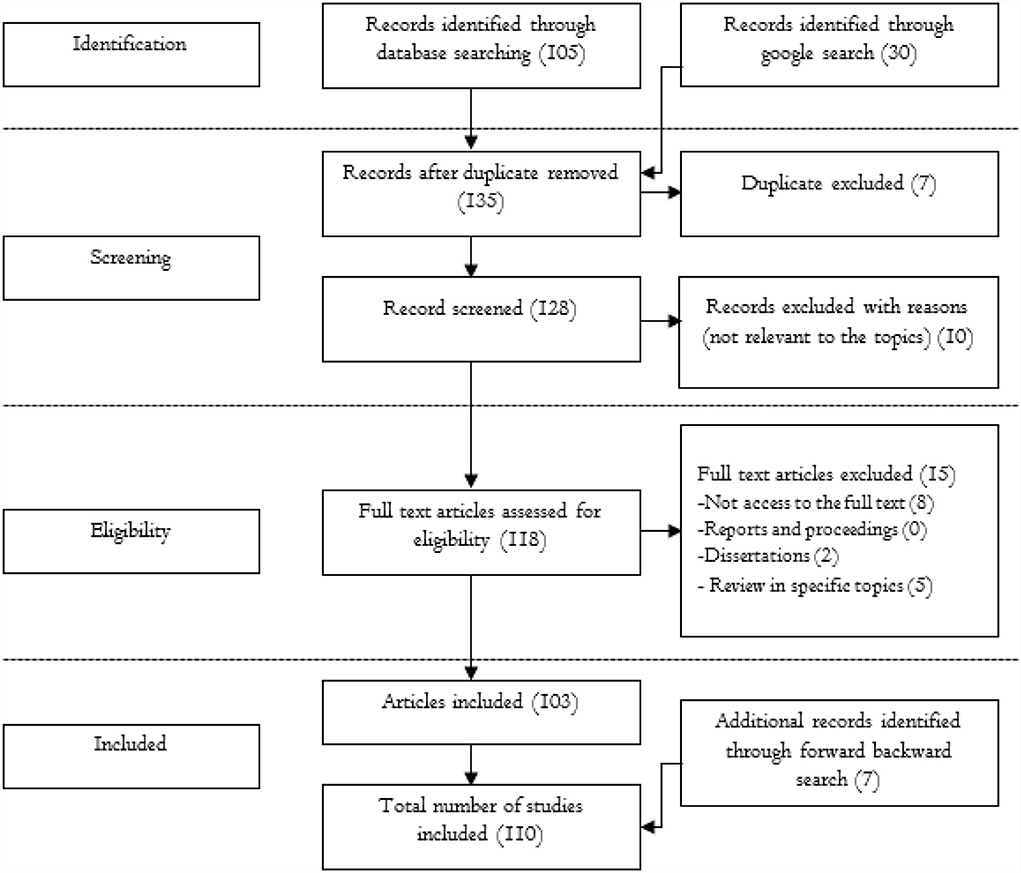
Figure 1. Literature search and evaluation process and decision making for inclusion.
Climate and agriculture in the Abbay basin
The Abbay basin—Brief description of the study site
The Abbay basin is the Ethiopian part of the Blue Nile River Basin of the Nile river located in the northwestern part of Ethiopia between 7° 40' N and 12° 51' N, and 34° 25' E and 39° 49' E. It is also commonly known as the Upper Blue Nile Bain. The basin is the second largest in area coverage and the largest in annual runoff compared with the other river basins in the country. It covers 20% of the country's total surface area and 60% of Amhara, 40% of Oromiya and 95% of Benishangul-Gumuz Regional States. Its major sub-basins include Beshilo, Welaka, Jemma, Muger. Yilma and Awulachew (2009) classified Abbay basin into 16 sub-basins. The name of the sub-basins is Guder, Fincha, Anger, Didessa, Wonbera, Dabus, Belles, Dinder, Rahad, Tana, North Gojjam and South Gojjam (Figure 2). Abbay basin covers an area of 199,812 km2 and it generates 60% of the water flow of the Nile River (Conway and Hulme, 1993; Sutcliffe and Parks, 1999). The basin is characterized by rugged topography in the center and eastern part and generally flat lowlands in the western part. Elevation ranges from 470 to 4,260 m asl. About 60% of the basin's area is highland with elevations of ≥1,500 m asl, and the remaining 40% is lowlands. Gently sloping lands with slopes of 0–15% accounts for 64% of the total area of the basin, while the remaining 36% has slopes of >15%. This indicates that much of the lands are suitable for agriculture from topography point of view.
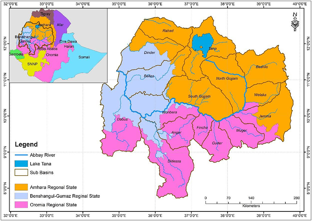
Figure 2. Sub basins of the Abbay basin.
The main river in the basin is the Abbay River. It originates from Lake Tana and flows about 1,450 km and merges with the White Nile to form the Nile river. Annual runoff generated from the basin is estimated at 49 BCM (BCEOM, 1998). It has a potential to produce 17,000 MW hydroelectric power. The per capita renewable water resource exceeds 2,500 m3y−1 (Johnston and McCartney, 2010). It is the most important basin in the country by most criteria as it contributes about 45% of the country's surface water resource, accommodates 25% of the population, and accounts for 20% of the landmass of the country (Erkossa et al., 2009). The basin also contributes some 40% of the country's agricultural produce (Erkossa et al., 2009). The potential irrigable land in the basin is estimated at 815,581 ha (WAPCOS, 1995). The total population living in the basin is nearly 37.6 million.
Small scale rain fed agriculture is the main livelihood system in the basin. Agricultural productivity is very low and its inter-annual fluctuation is large (Erkossa et al., 2009). A large part of this is related to hydro-climatic variability and lack of appropriate technologies for effective water resource utilization. There is a growing concern that water insecurity will be exacerbated in the coming decades because of climate change and projected frequent droughts and intense precipitation events (Funk et al., 2012). This coupled with continued population growth, land degradation and change in land use, water management will be much more complicated.
Several studies have attempted to understand the spatio-temporal variability of climate as well as climate change, and how this variability and change will affect water availability in the basin (Kim et al., 2008; Tesemma et al., 2010; Rientjes et al., 2011; Gebremicael et al., 2013; Tekleab et al., 2013; Berhane et al., 2014; Mengistu et al., 2014; Bayissa et al., 2015; Suryabhagavan, 2016; Mekonnen and Disse, 2018; Roth et al., 2018; Worqlul et al., 2018). There are also a few studies on how the links between hydro-climatic variability and water availability affect agriculture in the basin, and various recommendations have been provided on how to increase agricultural water productivity and agricultural water use efficiency. Those studies are however at localized scales and fragmented and hence do not provide a full picture of the basin. It is necessary to bring all relevant studies and insights together for a full-perspective understanding of the situation in the basin. This paper reviews and assesses the state of knowledge on agricultural water security issues in the basin; it covers climate variability and climate change, agricultural water management practices, and identifies important gaps that need to be addressed in future research and development endeavors.
Climatology of the Abbay basin
The Abbay river basin has diverse and variable climate which is related to the variations in topography and latitude (BCEOM, 1998; Conway, 2000; Tekleab et al., 2014). There are distinct local climatic regions in the basin, ranging from hot and arid areas along the Ethio-Sudan boarder to cool highlands and even humid-cold mountain peaks (Tekleab et al., 2014).
Across the basin, long-term mean annual rainfall varies between 1,200 and 1,800 mm, and ranges from about 1,000 mm near the Ethiopia/Sudan border, to 1,400 mm in the upper part of the basin, and in excess of 1,800 mm in the south in the Dedessa sub-basin (Conway, 2000). The same source notes that 70% of the annual rainfall falls between June and September. Awulachew et al. (2008) reported the average annual rainfall to be between 1,400 and 1,800 mm, ranging from about 1,000 mm near the Ethiopia– Sudan border to 1,400 mm in the upper part of the basin, and in excess of 2,000 mm in the Didessa and Beles sub basins. Other studies reported similar results about the spatial pattern of annual rainfall in the basin with slight differences in magnitude (Sutcliffe and Parks, 1999; Abtew et al., 2009). In terms of seasonal distribution, the National Meteorological Agency (NMA) identifies three distinct seasons (NMA, 2013). These are commonly known as Kiremt, Belg and Bega seasons. The Kiremt season is between June and September, and some 70–90% of the annual rainfall occurs during this season. The Belg season is between February and May. This is the short but the second most important rainy season for agricultural production in the country as a whole. The Bega season is generally dry and so rainfall is not expected in most parts of the country. Mekonnen and Disse (2018) analyzed rainfall data from 15 stations located in and around the basin, and their result shows mean seasonal rainfall of 148 mm, 238 mm and 1,065 mm for Bega (October–January), Belg (February–May) and Kiremt (June–September), respectively. This shows that about 74% of annual rainfall is concentrated between June and September (Kiremt season).
BCEOM (1998) identifies four clusters in the spatial pattern of rainfall in the Abbay basin, two with relatively high rainfall and two with relatively low rainfall amounts (Figure 3). The first cluster is found in the southeastern part and receives annual rainfall of 1,400–2,200 mm and a long wet season, which provides good conditions for agriculture. This cluster includes Guder, Fincha, Anger, Dedessa and western part of Dabus sub basins. The second one in the central part of the basin also has relatively high annual rainfall (1,400–2,200 mm) but there is a more pronounced seasonality, characterized by a shorter wet season and longer dry season. Lower part of Tana, upper part of South Gojjam, northern Beles and south eastern part of Dinder sub basins are part of this cluster. These areas are the major grain producing parts of the basin. The third in the eastern part of the basin is characterized by relatively low annual rainfall (<1,200 mm) distributed in two rainy seasons in a bimodal pattern. Beshilo, North Gojjam, Welaka, Jemma and Muger sub basins are found in this cluster. These areas are the most drought-prone parts of the basin. The fourth covers areas in the west and north-west part and receives low annual rainfall (<1,200 mm) which occurs in the main rainy season. This cluster includes western part of Dabus, Wonbera, lower part of Beles, western part of Dinder, Rahad and northern part of Tana sub basins. This part experiences high evapotranspiration losses.
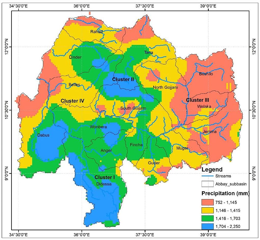
Figure 3. Rainfall clusters in the Abbay basin (prepared based on BCEOM, 1998).
The broader spatial patterns of rainfall in the basin are, in addition to topography and latitude, related to the sources of moisture to the Ethiopian highlands. The major rain producing mechanism in Ethiopia in general and the Abby basin in particular is the movement of air masses associated with the Inter-Tropical Convergence Zone (ITCZ), which moves seasonally from South to North and back (Griffiths, 1972; Gamachu, 1977; BCEOM, 1998; Conway, 2000; Awulachew et al., 2008). Conway (2000) clearly describes the mechanism as during the dry season, October to January, the ITCZ lies south of Ethiopia and does not reach the basin. Thus, continental dry air mass from Northeast causes dry period in the basin. The ITCZ moves up to the North around June, thus the southwest air stream extends over all highlands of Ethiopia to produce the main rainy season in the basin. Some areas in the basin are also receiving rainfall between February and May, and which is considered a small rainy season in the country (BCEOM, 1998; Conway, 2000; NMA, 2013).
Next to rainfall, temperature is the other important climatic element which governs water resource availability. Temperature exhibits temporal and spatial differences over the basin but not as much as that of rainfall (Conway, 2000). According to Yilma and Awulachew (2009), the highest temperature is observed in the northwestern part of the basin, in parts of Rahad, Dinder, Beles and Dabus sub basins. In these sub basins the maximum temperature is in the range of 28–38°C and minimum temperature is in the range of 15–20°C. Temperatures are generally lower in the highlands in the central and eastern parts of the basin (Figure 4). In these areas, maximum temperature ranges from 12 to 20°C and minimum temperature ranges from −1 to 8°C. In terms of temporal variability, March to May is the hottest period and November to February is the coldest period in the basin (Yilma and Awulachew, 2009).
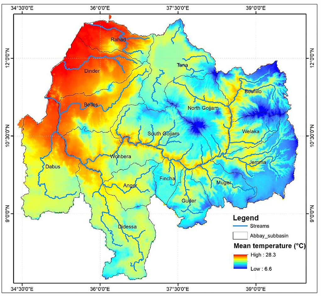
Figure 4. Mean temperature in the Abbay basin.
Evaporation is a key climatic element that affects water budget of basins. Potential evapotranspiration (PET) is generally highly correlated with temperature. For the Abbay basin, Yilma and Awulachew (2009) estimates annual PET to be between 1,056 and 2,232 mm. A high annual PET of between 1,800 and 2,232 mm per year is estimated for the northwestern part of the basin, in Dinder, Rahad, and parts of Beles and Didessa sub basins. The eastern and southern parts experience lower PET ranging between 1,200 and 1,800 mm per year and the lowest PET of below 1,200 mm per year is observed in parts of the highlands.
In general, climatic resources in the basin indicate presence of huge potential to generate water; however, there is high spatial and temporal variability that causes variability in water availability in the basin. This is associated with the meso scale rainfall producing mechanisms and micro scale modifiers like topography. There were efforts to cluster the basin based on hydrological characteristics to capture distinct hydrological process and water availability (e.g., Gebrehiwot et al., 2011; Berhanu et al., 2013, 2015; Gebregiorgis et al., 2013; Berhane et al., 2014). Most of these efforts of regionalization are very broad and only useful for strategic planning and focusing on spatially variability without giving much attention of the temporal one. Apart from hydrological based regionalization, climate zonation for agricultural technology extrapolation domain developed by Global Yield Gap Atlas over Ethiopia. This climate zonation is very crude in terms of characterizing the spatio-temporal characteristics of relevant climatic elements for operational water management practices. All in all, these relatively broad scale regionalization and characterization are useful for strategic planning; however, for operational and context specific technology targeting, a higher spatial and temporal resolution is much needed.
Agriculture in the Abbay basin
Agriculture specifically small scale farming is the main livelihood system in the basin. In general, it is characterized as mixed-crop livestock agriculture in the highland and pastoralism in the lowland areas. Erkossa et al. (2009) identified nine distinct farming systems in the basin. These are Tef based single cropping, Maize based single cropping, Sorghum based shifting cultivation, Barely based double cropping, Barely based single cropping, Maize based shifting cultivation, Coffee-maize complex, Sorghum based single cropping and forest (Figure 5). In terms of relative area coverage, the Tef based single cropping is the largest farming system and it accounts for 30% of the total area of the basin. Erkossa et al. (2009) further divide the cereal based crop cultivation, which covers over 90% of the basin, into single cropping, double cropping and shifting cultivation sub systems, which, respectively, cover about 60, 10, and 20% of the area. The single cropping cultivation is dominated by Tef, Maize and Sorghum crops and account for about 50% of the area. Barely cropping dominates the double cropping area which has a potential to grow two times in a year though the relative area coverage is very small.
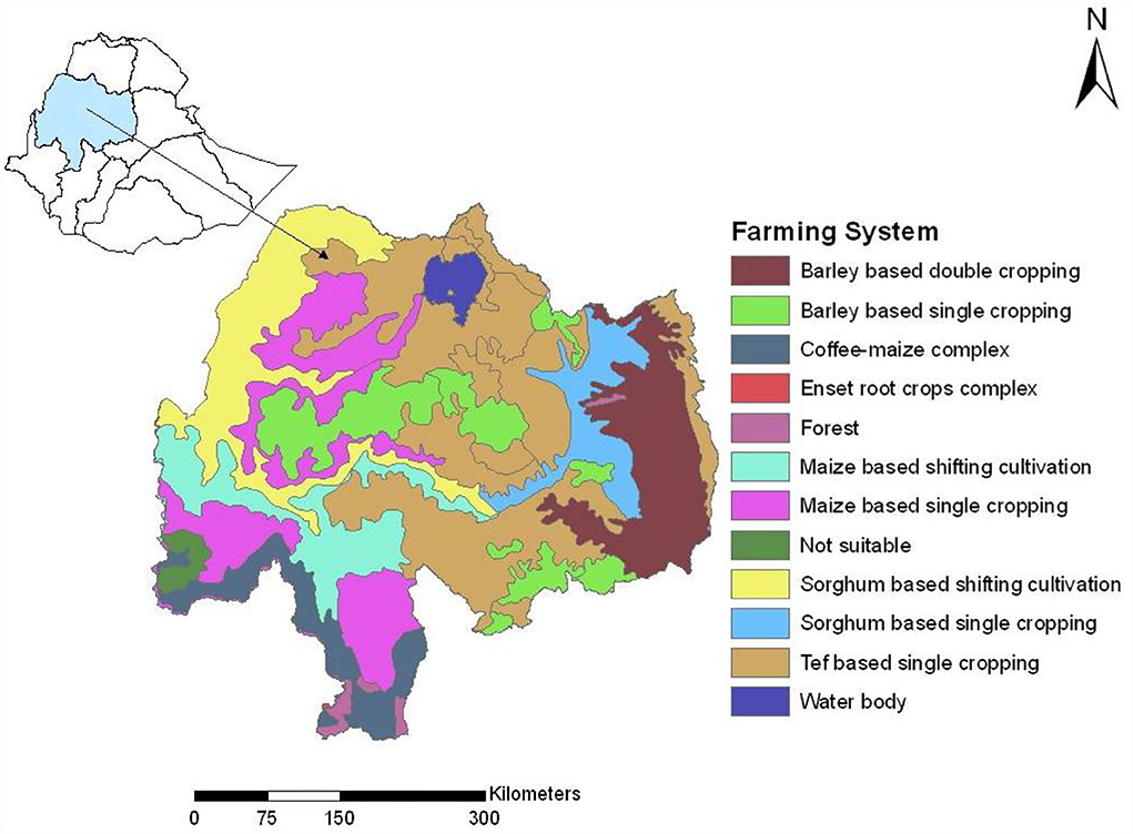
Figure 5. The major farming systems of the basin. Source (Erkossa et al., 2009).
The productivity of all these farming systems is very low, almost <1.0 ton per hectare (Erkossa et al., 2009). This is, according to Erkossa et al. (2009), due to many interrelated factors including high population pressure, soil erosion and land degradation, unreliable rainfall, low water storage capacity of the soils and catchments, crop pests and diseases, soil acidity, water logging, fragmentation of farm lands, limited use of improved technologies such as improved crop varieties, soil fertility management (fertilizers, liming), poor water management (irrigation and drainage), soil and water conservation as well as farmers traditions.
Hydrology in the Abbay basin
Abbay river originates from its source Gish Abbay (Sekela) to flow North ward and enter Lake Tana at the Southwestern tip. The main Abbay River flows out from Lake Tana in the southeast. Stream flows in the basin generally shows a pattern that have low during April and high in August months (Figure 6). However, slight shift in month is observed in peak discharge at the outlet of Lake Tana, which is 1 month later in September (Ayele et al., 2019).
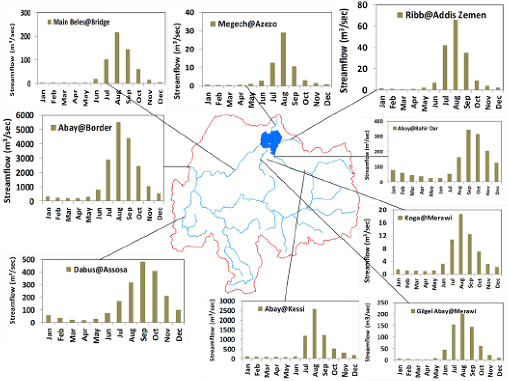
Figure 6. Stream flows measured in Abbay basin. Source (Ayele et al., 2019).
The minimum discharges also show a similar pattern at the Sudan border which has lowest flow in April, while 2 months later in June at Lake Tana. The difference is due to the storage effect of Lake Tana in delaying the release of flows. The discharge from the Gilgel Abbay, one of the tributaries that flow into Lake Tana, also shows storage lag with maximum discharge in August and minimum in April. Similar pattern is also observed at Sudan border. Flows at both places are strongly influenced by dry and wet years despite the natural storage ability of Lake (ABDO, 2020).
There is a 10 times increase in discharge between the Abbay river at Lake Tana and the Abbay at the Sudan border which demonstrates the importance of the inflow yielded by the additional 156,933 km2 catchment area from the Abbay tributaries (Figure 7).
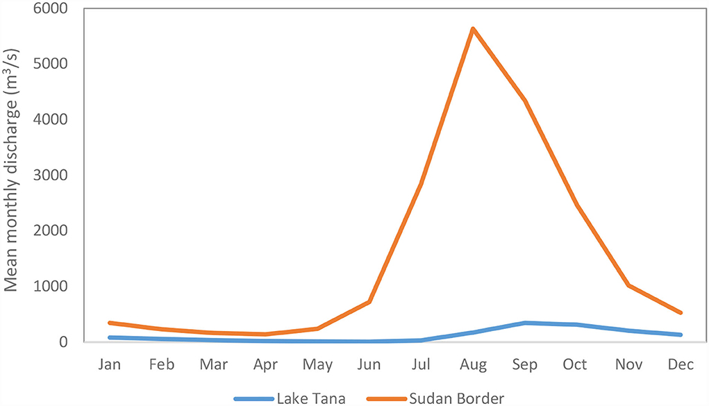
Figure 7. Mean monthly discharge of the Abbay river at the Lake Tana and the Ethiopian/Sudan Border (m3/s). Source (ABDO, 2020).
Climate change impacts on water and agriculture in the Abbay basin
Climate change in the Abbay basin
Climate change is a major threat to water security in Ethiopia. Many studies have evaluated climate variability and climate change impacts on water resources (Conway, 2000, 2005; Osman et al., 2000; NMA, 2001, 2007; Conway et al., 2004; Seleshi and Zanke, 2004; Verdin et al., 2005; Bewket and Conway, 2007; Cheung et al., 2008; Abdo et al., 2009; Abtew et al., 2009; McSweeney et al., 2009; ACCRA, 2012; Ayalew et al., 2012; Tesso et al., 2012; Viste et al., 2012; Jury and Funk, 2013; Nicholson et al., 2018). All these studies agree that there is consistent warming trend in most parts of the country and the Abbay basin. However, evidence on rainfall is contradictory which could possibly be explained by the different spatial and temporal scales and the time periods considered by the different studies.
Some studies have noted that strong local scale variations exist in rainfall trends. For instance, Mengistu et al. (2014) evaluated spatiotemporal variability of rainfall and temperature over the upper Blue Nile basin and they found significant increasing and significant decreasing trends in different parts of the basin. According to this study, the eastern part of the basin experienced significant increasing trend in summer and in the western part during winter and autumn. Significant decreasing trend was found in the western part during spring and some part in the north during summer. Bewket and Conway (2007) reported significant increasing trends in annual and summer rainfall in the northeastern part of the basin. Alemu and Bawoke (2019) conducted a study on rainfall variability in the basin using gridded rainfall data for the period 1981–2017. Their study shows moderate inter-annual variability and much larger variation in the seasonal rainfall between years. Their study further reveals that there is an overall increase in annual rainfall and seasonal rainfall (except winter). Samy et al. (2019) investigated rainfall characteristics in the upper Blue Nile Basin over the period 1953 to 2014, and noted that the basin experiences variable rainfall events causing severe droughts and floods in different years. They also reported significant increasing rainfall trend over the northeastern and eastern-central parts of the basin. Regional level study by Nashwan and Shahid (2019) in Nile river basin indicates that annual rainfall was increasing only at some locations in the main Nile and Atbara sub-basins at a rate of 0.26–26.4 mm/decade and a significant decreasing trend over a large part of Nile river basin was found for extreme rainfall days (– 0.53–0.75 day/decade)
A number of studies have also generated projected climates and assessed impacts on water resources in the basin. Taye et al. (2011) reviewed some of these studies and concluded that clear discrepancies and contradictions exist in their findings. For instance, the results from Bewket and Conway (2007), Conway (2000), and Gebremicael et al. (2013) showed absence of significant change on the amount of rainfall and there was no consistent pattern or trend in rainfall. Kim et al. (2008) used outputs of six GCMs to project future precipitation and temperature and found that the changes in mean annual precipitation from the six GCMs range from −11% to +44% with a change of 11% from the weighted average scenario at 2050s. The changes in mean annual temperature range from 1.4 to 2.6°C with average change of 2.3°C from the weighted average scenario. Yates and Strzepek (1998a) used 3 GCMs and the result was that the changes in precipitation range from −5% to +30% and the change in temperature range from 2.2 to 3.5°C. In another study, Yates and Strzepek (1998b) used 6 GCMs and the results showed changes between −9 and 55% for precipitation, and between 2.2 to 3.7°C for temperature. Elshamy et al. (2009) used 17 GCMs and the result showed that changes in total annual precipitation range between −15% and +14% but the ensemble mean of all models showed almost no change in the annual total rainfall. All models predicted the temperature to increase by between 2 and 5°C. Worqlul et al. (2018) studied climate change in the Abbay basin and found that daily maximum and minimum temperature will increase throughout the future time horizons. The minimum and maximum temperatures will increase by 3.6 and 2.4°C, respectively, toward the end of the 21st century with A2 climate scenario. They also evaluated the trend of potential evapotranspiration and found that it will increase by 7.8%, although trends in annual rainfall did not show statistically meaningful trends. They observed also a notable seasonality in the rainfall pattern, such that dry season rainfall amounts are likely to increase and wet season rainfall likely to decrease.
Gudoshava et al. (2020) conducted regional level analysis of climate change projection over the Greater Horn of Africa using the outputs of a 25-member regional multi-model ensembles of the CIMP5 models from Coordinated Regional Climate Downscaling Experiment project. The study shows that change in mean intra-seasonal rainfall characteristics at 1.5 and 2°C global warming levels especially for the June-September and October-December seasons. During the June-September season, delayed onset, reduction in consecutive wet days and shortening of the length of rainy season over parts of the northern sector under 2°C. During the October -December season, the region is projected to have late-onset, delayed cessation, reduced consecutive wet days and a longer season over most of the equatorial region under the 2°C global warming level.
All the above studies show contradictory results for the basin particularly on rainfall amount, intensity, duration and seasonality in the future. Most of the studies reviewed in this study used only few GCM models without prior justification about how and why they selected those GCMs or some of their assumptions are not valid. Furthermore, the GCMs downscaling were carried out only for a small number of meteorological stations where their spatial representation is questionable. In addition, the downscaling techniques including the bias correction methods were not capable to capture extreme events in most of the cases. Apart from these, uncertainty of the climate models predictions is also a challenge to the credibility of findings of most studies (Bornemann et al., 2019). Recent study by Wainwright et al. (2021) indicates the source of uncertainty in climate projection in East Africa rainfall is related to parametrization of convection. Conway (2017) also stated that for many parts of Africa, GCM projections remain highly divergent and there is a need further research in the area particularly in consideration of El Niño-Southern Oscillation (ENSO) behavior which is the source of uncertainty in climate modeling. Apart from the large scale atmospheric circulation, thermodynamic conditions like moisture content, moisture transport and local/mesoscale feedback are highly contributed in influencing climate variability over the Ethiopian highland. Souverijns and Thiery (2016) reports that more than 77% of rainfall condition over Easter Africa is influenced by moisture amount and flow, and local/mesoscale feedbacks. This suggest that climate models, particularly the RCMs ones, that consider these thermodynamic conditions are more relevant to Ethiopian Highland condition. Further research in this aspect in terms of properly identifying and quantifying the drivers and representing in the climate models are very necessary steps toward on accurate projection of climate over Eastern Africa in general and over Ethiopia in particular. All these technical issues are very critical to understand what the future holds in the Abbay basin from the climate change perspective. These are important gaps to be tackled by future research.
Climate change impacts on hydrology and water resources in the basin
The Abbay basin is one of the most sensitive areas to climate change impacts on water resource systems (Kim and Kaluarachchi, 2009). Many studies exist on potential impacts of climate change on stream flows in the basin (Conway and Hulme, 1993; Bewket, 2003; Kebede, 2009; Gebrehiwot et al., 2010; Rientjes et al., 2011; Dile et al., 2013; Gebre and Ludwig, 2015; Taye et al., 2015; Ayele et al., 2016; Wagena et al., 2016). These studies have produced widely differing results due to differences in timeframes of station records analyzed, differences in global emissions scenarios considered and other aspects of model simulations. For instance, Conway and Hulme (1993) reported increase in annual flow for Upper Blue Nile Basin (Abbay basin) and Gebre and Ludwig (2015) also reported increasing trends of annual flows for four catchments (Gilgel Abbay, Gumer, Ribb, and Megech) of the Abbay basin. Recent study by Alaminie and Jury (2022) stated increasing trend of runoff based on ensemble model projection. Whereas, Bewket and Sterk (2005), Kebede (2009), and Gebrehiwot et al. (2010), and reported decreasing trends of annual flows of Chemoga, Koga and Gilgel Abbay catchments of the Abbay basin, respectively. Some studies reported absence of any change in annual flows. For instance, Tesemma et al. (2010) found no change in annual flow of the Abbay basin, except during the main rainy season (June to September).
Some studies (e.g., Conway et al., 2004; Elshamy and Wheater, 2009) pointed out that the impact of climate change on the river flow is insignificant, whereas Taye and Willems (2012) showed the impact of climate change to be uncertain. They further showed how global phenomena and local conditions could affect flows in the Abbay basin. According to their report, high flow extremes of the Blue Nile are strongly influenced by climatic oscillations while the low flows are influenced by the combined effects of climate and land use/land cover change.
A scenario-based study by Kim et al. (2008) showed that precipitation could change by 11% and temperature by 2.3°C from the weighted average scenarios. As a result, the relative change in mean annual runoff was by 4%. He used outputs of six GCMs to project future precipitation and temperature and analyzed hydrological responses to climate change effects using a simplified monthly water balance model. Another study that complements this finding is by Aich et al. (2014), which used bias corrected model outputs of five Earth System Models (ESMs) of HadGEM2-ES, IPSL-5 CM5ALR, MIROC-ESM-CHEM, GFDL-ESM2M, NorESM1-M under scenarios of RCP2.6 and RCP8.5 for analyzing the impacts of climate change on the stream flow of four large African rivers, and reported increasing trend in precipitation. Furthermore, projections of the Soil and Water Integrated Model (SWIM) driven by the five corrected climate models agree almost completely on positive trends of stream flow at El Diem gauging station, which corresponds to the precipitation trend.
A more comprehensive study by Elshamy et al. (2009) which used 17 GCMs reported the ensemble means of all models showed almost no change in the annual rainfall in the basin. The models predict temperature to increase by between by 2 and 5°C. In terms of changes in stream flow, more models (eleven) predicted flow reductions than those showing increases (six). The ensemble mean annual stream flow at El Diem was projected to reduce by 15% compared to the baseline. Another study by Dile et al. (2013) on impact of climate change on Gilgel Abbay found decreasing and increasing trend of stream flow during 2010–2040 and during 2040–2100, respectively, in response to decrease and increase of precipitation in the basin. Their study indicates that mean monthly flow volume will decrease by between −40 to −50% during 2010–2040 and may increase by more than double during 2070–2100. They found also that impact of climate change is significant on seasonal mean flow during Belg and Kirmet seasons.
Change in extreme precipitation events in relation to the changing climate has also been evaluated by some studies. For instance, Worku (2015) used precipitation data from two GCMs, namely HadCM3 and CGCM3 and showed that in most parts of the basin rainfall intensity will increase in the future. The increase in rainfall intensity causes increase in hydrologic extremes. In another study, Worqlul et al. (2018) investigated effects of climate change on stream flow of two sub-catchments in the upper part of the basin. According to this study, minimum and maximum temperatures are expected to increase by 3.6 and 2.4°C, respectively, at the basin level. Evapotranspiration is predicted to increase by 17.8% by 2100. The seasonal stream flow is expected to increase by 64% during the wet season and decrease by 19% during the dry season. Meresa and Gatachew (2016) reported that wet/dry spell will significantly decrease/increase due to climate change in some parts of the basin, Dabus and Birr sub basins, while in Beles and Gilgel Beles sub basins, there will be increase/decrease in wet/dry spells but not statistically significant, respectively. Gelete et al. (2020) reviewed 73 journal articles on impact of climate variability and climate change on the hydrology of Blue Nile river basin and they concluded temperature will increase while rainfall and stream flow will decrease. Wagena et al. (2016) studied impact of climate change on water resources of two sub basins, Tana and Beles sub-basins in the Abbay basin. Their results show increase in mean annual flows in both sub-basins which was attributed to increase in the length of the monsoon season by 4–6 weeks. Recent study by Mengistu et al. (2021) indicates that surface runoff is projected to increase by up to 14% by the end of 21st century, however, the increase in surface runoff could not increase the total water yield of the Basin. Instead, the total water yield of the Basin is estimated to decrease.
With respect to impact of climate change on groundwater, much has not been done in the basin. Some studies by Setegn et al. (2011) and Woldesenbet et al. (2018) addresses the impact of climate change groundwater flow in the basin particularly in Lake Tana basin. Setegn et al. (2011) used 17 GCM outputs from the World Climate Research Programme's Coupled Model Intercomparison Project phase 3 (CMIP3) and analyzed the contribution of groundwater flows to stream flows. Their study indicates that a likely decrease in groundwater flow and soil moisture. Other study by Woldesenbet et al. (2018) reported an increase contribution of groundwater to streamflow. Tigabu et al. (2021) on the other hand reported groundwater contribution to stream flow is projected to decrease whereas surface runoff is projected to increase. Their study concluded that rainfall trends alone are not revealing future water availability and may even be misleading, if regions rely heavily on groundwater. All these studies again show a contradiction of results how groundwater contribution to streamflow in the basin. Further, most of the studies focused on contribution to stream flow and very less in change in magnitude of groundwater flows. All these indicated that the need for comprehensive study of climate change impact on ground water resources is very necessary since groundwater is one of the resources to address food security issue in the basin.
In summary, most studies show inconsistent results about rainfall amount, but some studies indicate increasing rainfall amount due to increases in rainfall intensity and/or increase in monsoon season length suggesting a potential increase in stream flows. Regarding temperature, almost all studies concur that it is increasing with different magnitudes depending on the models and scenarios used. A more spatially explicit assessment of climate change impacts on hydrology, groundwater and water resources will benefit agricultural planning and decision making at relevant spatial scales.
Climate change impacts on agriculture
The adverse impacts of climate change in the Abbay basin are mainly through the changes it causes on water availability, water utilization and water stability for agricultural uses. Despite the basin receiving fairly high rainfall amount per year, it is characterized by high variability in both spatial and temporal distribution, with frequent dry spells that significantly reduce crop yields and sometimes lead to total crop failures. Bewket (2007) studied rainfall variability and agricultural vulnerability in the Amhara Regional State of Ethiopia, which covers a large part of the basin, using rainfall and main season cereal yield data, and reported significant correlations between seasonal rainfall amount and crop production. This shows the dependence of crop production on climate variability particularly rainfall variability in the basin. Besides climate variability, poor water and land management and associated land degradation exacerbate climate change impacts on agricultural productivity and contribute to perpetuating rural poverty (Erkossa et al., 2009). In general, crop productivity in the basin is very low, <1.0 ton per hectare on average (Erkossa et al., 2009).
As discussed above, BCEOM (1998) has identified four rainfall regions or area clusters in the basin; identified as two high rainfall and two low rainfall areas. This is a very coarse rainfall characterization and regionalization for agricultural planning and decision making. The first cluster covering the southeastern part receives annual rainfall of 1,400–2,200 mm and has a long wet season, which provides a good condition for agriculture. The growing period in this cluster is the longest in the basin and it ranges from 240 to 365 days. Rainfall in this area is also reported to be the highest in Ethiopia (2,200 mm yr−1). The length of the growing season together the amount of rainfall makes this cluster one of the high potential areas to grow long cycle and high yielding crops. This cluster is dominated by Maize based cereals in the south and Tef based cereals in the east. Erkossa et al. (2009) reported that the average yield of Maize and Tef crops in the area are 22.04 Q/ha (1Q = 100 kg) and <10 Q/ha, respectively, and these figures clearly indicate the very low crop productivity of the cluster. Haileslassie et al. (2007) have also noted that water productivity is very low. Thus, this cluster is characterized by good water availability but poor water utilization. Mellander et al. (2013) reported that wet season rainfall amount as well as length of the wet season is likely to increase, while the dry season length decreases in this area (Figure 8). The same study also reported a potential decrease in rainfall intensity. These all are favorable conditions for improving agricultural production, including through improved green water management at farm scales.
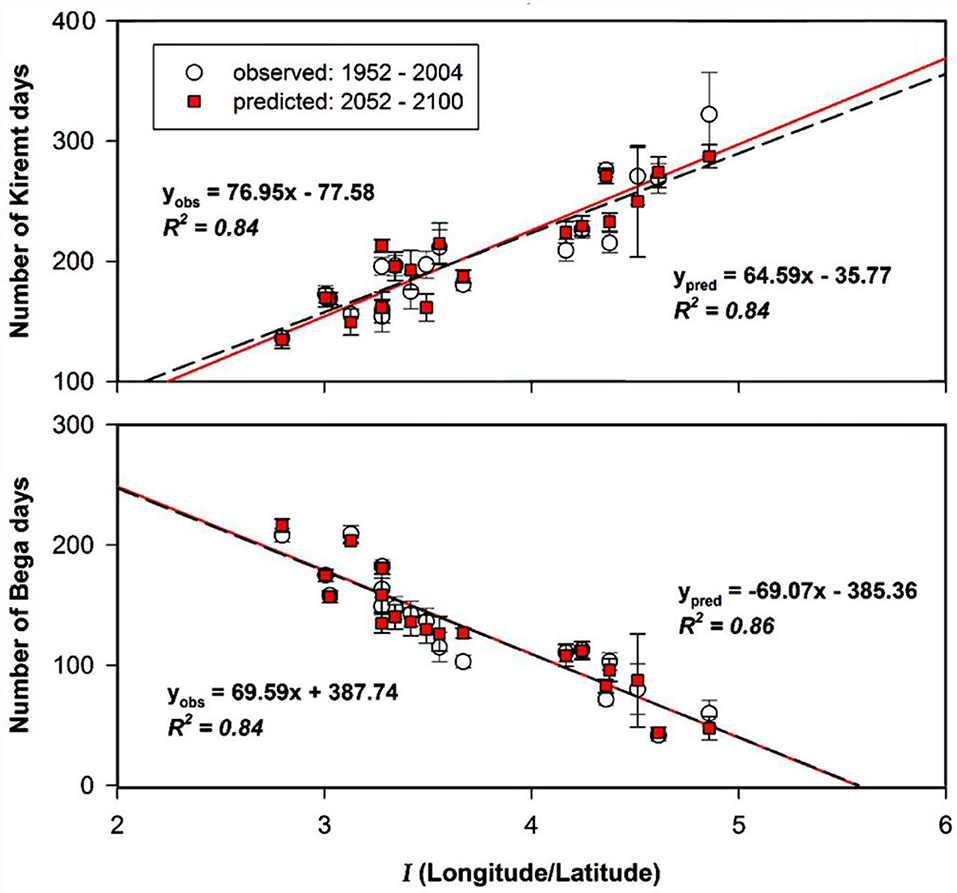
Figure 8. Presence of Kiremt and duration of Kiremt (the main wet season) and Bega (the dry season) correlated to the index of coordinates, I. The correlation represents observed data (1952–2004) in circles and predicted data a century later (2052–2100) in squares over the upper Blue Nile Basin. Source (Mellander et al., 2013).
The second cluster in the central part is characterized by a shorter wet season and a longer dry season. The short wet season has 3–4 months and the remaining months are dry. This is the main grain producing area in the basin. However, the short wet period and the high rainfall intensity are major challenges to agricultural production. Most of the rain turns into runoff due to high intensity and this also causes high soil erosion affecting the ability of the remaining soil to store water for long. Further the short rainy season does not allow farmers to grow long cycle and high yielding crops. This cluster is dominated by Tef-based cereals with barley, wheat and sorghum crops and farmers, on average, produce some surplus over their subsistence needs despite the challenges of variable rainfall characteristics (ENTRO, 2006). During the long dry season, farmers are not fully engaged in farm activities and this indicates the low labor productivity in the area. Investing in green water management possibly enhances crop, water and labor productivity by extending the cropping season (ENTRO, 2006), but this has not been explored by scientific research. Improving agricultural productivity in this cluster is particularly important, because of the highest population density in the basin (Figure 9). In addition, Mellander et al. (2013) suggest that the wet season is likely to decrease and rainfall intensity is likely to increase (Figure 8), which will compound existing water security challenges. The high and growing population density combined with the current and future rainfall characteristics suggests that this cluster is one of the most vulnerable to water and food security risks.
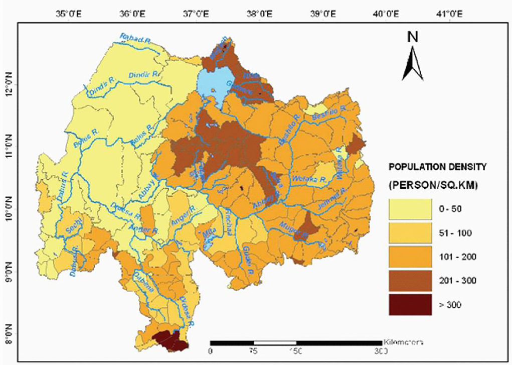
Figure 9. Population density in the Abbay basin. Source (Central Statistical Agency (CSA), 2007, reproduced from Yilma and Awulachew, 2009).
The third cluster in the eastern part of the basin is characterized by relatively low annual rainfall (<1,200 mm) that is distributed in two rainy seasons in a bimodal pattern. The short rainy starts in January or February and extends to end of May; and the main rainy starts in mid July and extends to mid September. Beshilo, Welaka and Jemma are the main sub basins in this area. The cluster is dominated by Barely based double cropping, and delayed start and early withdrawal of rain (in both the short and main rainy seasons) is one of the major production constraints. Further, 70% of the area is characterized by soils with low water storage capacity (Erkossa et al., 2009). The unreliable nature of the rainfall has made use of fertilizers and improved seeds a risky venture and so contribute to the low crop productivity in this cluster. It is also one of the drought-prone and water scarce areas with unpredictable rainfall onset and cessation times, and crop and livestock water productivity is estimated at only USD 0.5 m−3 in this area (Haileslassie et al., 2007).
The fourth cluster covers the western and northwestern parts of the basin and receives relatively low rainfall (<1,200 mm) and the rainfall occurs in the main rainy season. Variability and shortage of rainfall are the main characteristics of the area (BCEOM, 1998). Further, evapotranspiration loss is high. Agriculture in this cluster therefore faces significant climate related risks. The farming system consists of both intensive farming of maize-based perennial crops in the south, upstream of the Didesa sub-basin, and extensive farming of maize-sorghum complex in the western lowland valleys of Dabus and Beles, upstream of the Dinder and Rahad sub-basins. The maize-sorghum complex extends to Sudan where sorghum becomes a dominant crop. Compared to other other parts of the basin, population density low (0–10 person km−2) and problems of soil erosion are not apparent (Mo, 1998). However, the farming system is characterized by low crop and water productivity which is related to poor land and water use practices apart from the variability and shortage of rainfall (Haileslassie et al., 2007).
In general, agricultural productivity in the Abbay basin is constrained by high climate variability rather than low water availability; rainfall distribution is extremely uneven both spatially and temporally. On the other hand, high rainfall intensities result in low infiltration and high runoff rates, causing severe soil erosion and land degradation, which in turn contribute to water insecurity for agriculture and perpetuate the low agricultural productivity and the widespread food insecurity (Lautze et al., 2003; Deressa, 2007; Suryabhagavan, 2016). High population growth rate and the cultivation of steep lands and marginal areas exacerbate the problem; soil erosion in the cultivated highlands of Ethiopia is estimated at 42 t/ha, on average (Hurni, 1990; Tamene and Vlek, 2008). The low crop yield in the basin, which is, on average, about 35% of the potential, is typically not due to the lack of water but rather a result of the inefficient management of water, soils and crops (Amede, 2011). This implies that poor water utilization is the major water security challenge in the basin. The gap between actual and attainable yields suggests that there is a large potential for yield increases (Rockström et al., 2010). It has been demonstrated that improved rainwater management interventions can improve water security and reduce poverty levels by ~22% (Awulachew et al., 2013). Green water management interventions can therefore mitigate production risks associated with increasing rainfall variability due to climate change (Kato et al., 2009).
Climate change has already intensified the problem of water insecurity in the basin. Several studies reviewed above project significant increases in temperatures. The projection for rainfall is much less certain, although on average a relatively small increase is expected for the country as a whole. For instance, Wagena et al. (2016) estimate that the monsoon season could be longer by 4–6 weeks. This means increases in rainfall amount that potentially benefits farmers to grow long cycle and high productivity crops or even creating opportunity for double cropping. However, it could be associated with increase in rainfall intensity which could lead to high surface runoff and soil erosion risk (Worku, 2015). Soil erosion lowers crop production by removing valuable topsoil and plant nutrients. Also, increased runoff implies less infiltration, and reduced soil water and ground water recharge. Increase in potential evapotranspiration is also expected as a consequence of increase in temperatures (Worqlul et al., 2018), and this implies an increased water demand for crop production in the basin.
Climate change induced water security risks on agriculture in the Abbay basin will involve changes in amount, intensity, duration and timing of rainfall, and that change in temperature will enhance the demand for evapotranspiration. Hence, the increase in temperature will lead to increased water demand by farming systems. The full scale impact of climate change on agriculture in the basin is yet to be studied. The possible impact of increased temperature particularly on C4 crops (tef, maize, sorghum and millet) is displacement from their original areas (Tesfaye et al., 2016). This implies a possible change in farming system in the basin particularly dominated by Tef in the central highland and those dominated by maize and sorghum in the west and southwest parts of the basin. The change in farming system will also change the pattern of demand and consumption of water.
From the foregoing, climate induced water security risks impacting agricultural production in the basin in different ways depend on the spatiotemporal distribution of rainfall. Climate change will aggravate impacts from the current climate variability. Poor natural resource management, including green water management along with spatiotemporal climate variability and change are the main water security risks to agriculture in the basin.
Other pressures aggravating water security risks to agriculture
Land degradation and population pressure
Land degradation and population pressure are key factors that aggravate water security risks on agriculture along with climate variability and change. Population pressure has been increasing in the Ethiopian highlands and this has contributed to extension of cultivation into steep lands and change in land use and land cover. Land degradation and water scarcity are closely interlinked as healthy land loses its natural capacity to store and filter water when it is degraded. The Abbay basin is one of the hotspots of soil erosion and land degradation in the highlands of Ethiopia (Hydrosult Inc., 2007; Awulachew et al., 2008, 2010). An estimated 302.8 million tons of soil is eroded from the basin annually, largely through sheet erosion; of this about two-thirds is from uncultivated land, i.e., communal grazing and settlement areas (Awulachew et al., 2008).
Hydrosult Inc. (2007) estimated annual reduction in grain yields in the basin due to soil erosion at 25,190 t, i.e., 0.6% of the total but this accumulates over the years; after 10 years it rises to 6% and after 25 years to 15% of annual crop production. Awulachew et al. (2010) reported the highest sediment yields to be from croplands, particularly in the small grain cereal-based farming systems mostly found in the central parts. The increasing population density in the area will contribute to water scarcity in the basin (McCartney et al., 2012).
In this review, it is found that there are different efforts to reduce land degradation particularly soil degradation through soil conservation and land management interventions in the country in general and in Abbay basin in particular. The target of most of the soil conservation and land management interventions is to reduce soil erosion, and existing evidences are only in this regards. However, recent global level understanding on land degradation is very related with water security as well. Healthy land has a natural capacity to store and filter water, but this capacity is lost when land is degraded (Tebebu et al., 2017). There are different land and water management interventions to restore degraded land, bring land degradation neutrality and address water security in long term. The effectiveness of such kind of interventions depends on context and site specificity. In this regard, evidences are very lacking in the country for proper targeting of interventions. Thus, it is suggested future research could be designed to fill gaps in terms of generating evidences for operational and strategic planning.
Land use and land cover change
Increase population is the major driving agent for land use and land cover change in most developing countries in response to increase demand to agricultural production (Maitima et al., 2009). In Ethiopia, particularly Abbay basin experiencing an expansion of agricultural land by converting natural vegetation (e.g., Zeleke and Hurni, 2001; Bewket and Sterk, 2002; Gashaw et al., 2017). On the other hand, recent study by Wondie and Mekuria (2018) arguing that rate of deforestation is decreasing in most part of Ethiopia including Abbay basin in response of plantation activities.
Land use and land cover change is closely interlinked with change in land surface processes like change in surface runoff, groundwater recharge, infiltration, interception, and evapotranspiration. Studying the impact of land use and land cover change on hydrological process and water resource is very important for planning and designing of environmental resource management and addressing water security issues as well. For instance, expansion of agricultural land at the expense of natural vegetation could increase runoff and decrease evapotranspiration however the degree of impact varies depending on the characteristics of a watershed or basin and agro-ecological settings of areas under study (e.g., Guo et al., 2008; Ma et al., 2009; Dong et al., 2015; Li et al., 2017; Yang et al., 2017; Mekonnen and Disse, 2018; Berihun et al., 2019). On the other hand, the change from vegetation cover to agricultural land could increase runoff during wet season and decrease during dry season due to reduced infiltration and reduced residential time in the soil. This is evidenced by study conducted in Dedesa sub basin of the Abbay basin considering land use and land cover change between 1986 and 2014 (Jemberie et al., 2016). The study uses SWAT model to simulate streamflow over 25-years period considering land use and land cover change, and it is found that streamflow increased by 29.44 m3/s for wet season and decreased by 4.44 m3/s in dry season. Though few studies conducted in parts of the basin (e.g., Dagnew et al., 2017; Gashaw et al., 2017; Woldesenbet et al., 2017, 2018; Worku et al., 2017; Mekonnen and Disse, 2018) to assess the impact of land use and land cover change impact on hydrological processes, they are mostly specific to single agro-ecological environment, uniform human activities and not spatially explicit in a way to plan operational intervention. There is no comprehensive basin level study on the impact of land use and land cover change on hydrological processes and water resource. Dile et al. (2019) suggested about the need of further study in the basin to better understand the responses of hydrological processes and water availability under LULC and climate change at small watershed scales under different agro-ecologies (Dile et al., 2019). This review paper also found out that this area is one of the critical gap that need to be addressed in future work for clear understanding of spatio-temporal variability of hydrological process and water availability. Such kind of information is necessary for proper design of context and site specific interventions in addressing of water security challenges.
Research and development responses to climate risks on agriculture
In response to the impact of extreme climate variability and change on water resource and agriculture in the country, significant investments have been made into water resource management and development, including in-situ agricultural water management and ex-situ water harvesting for supplementary irrigation. The in-situ agricultural water management mostly known as soil and water conservation has been implemented at relatively large scales in the basin since the early 1980s though much success has not been achieved (Tebebu et al., 2015; Zimale et al., 2017). One of the major factors to the limited success is the one-size-fits-all approach to technology selection and implementation. Most of the interventions did not take into account hydroclimatic and socioeconomic heterogeneity of the basin, particularly the rainfall characteristics in the basin that could lead to success in some places and failure in others (Eguavoen, 2009; Berihun et al., 2020). For instance, it is common to see fanya juu in high rainfall areas with inappropriate design to the local rainfall condition (Merrey and Tadele, 2011). The four rainfall clusters developed by BCEOM (1998) could only be used for strategic purposes and cannot be used for local scale planning and targeted agricultural development interventions.
There is also very limited research evidence on the types and design of soil and water conservation technologies for use in the different rainfall and agroecological regions of the basin and the country at large. Merrey and Tadele (2011) affirm that there has been very little systematic comparative research on the diverse soil and water conservation technologies, their performance, the conditions for which specific technologies are most appropriate, and the accompanying crop, land and water management practices needed to enhance land productivity. Most of the existing research on soil and water conservation is about erosion control, and not about improving agricultural water productivity. Bewket and Sterk (2003) and Bewket (2009) noted that the top-down approaches followed in planning and implementation of the past conservation activities was a major contributor to their limited success, as farmers did not maintain the structures or even destroyed them after the coercion was withdrawn. Local level priorities and stakeholder inputs are quite essential for successful implementation of such kind of interventions (Dorte et al., 2013).
There was large scale investment into construction of farm ponds for harvesting runoff after the drought of 2002/03. The drought mitigation and livelihood outcome of this initiative has not been thoroughly evaluated, but the few available studies reported that this too was largely a failure (Bewket, 2007, 2009). Similarly, Lemma (2007) stated that “most household ponds failed, despite good design and techniques, because the social, economic and management factors were inadequately integrated into the pond development system”. In general, water management practices and technologies, the various ways to improve the productivity of water used by crops, livestock and agroforestry, and the outcomes and social and economic impacts of these technologies are not well-researched in Ethiopia (Merrey and Tadele, 2011). Further, there is a research gap in evaluating the interactions and synergies among the diverse agricultural water management technologies and practices to address water security issues in the basin. Previous researches focused on evaluating single technology in multiple sites rather than the outcomes of a suite of integrated practices implemented in a watershed. Only few studies exist on assessment of outcomes of such integrated interventions. For instance, Temesgen et al. (2012) investigated the effect of integrating conservation tillage (CT) with soil conservation structures on surface runoff, water-logging, soil loss, crop yield and plowing convenience, comparing it with traditional tillage (TT) on five farmers' fields in a high rainfall area in the Abbay basin. They found that surface runoff was reduced under CT by 48 and 15% for wheat and tef, respectively, reduced sediment yield by 51 and 9.5% for wheat and tef, respectively, and reduced water-logging was observed behind soil conservation structures in CT compared to TT, and grain yields of wheat and tef increased by 35 and 10%, respectively.
Crop models based climate risk assessment and development of management options is another dimension helpful to target spatially explicit interventions, particularly addressing climate variability impact on agriculture (Corbeels et al., 2018). In this regard, Erkossa et al. (2009) evaluated effects of improving soil fertility on water productivity of crops in high rainfall areas in the Abbay basin using an integrated approach. They employed the FAO Aqua-Crop model to simulate water productivity of crops under varying soil fertility scenarios (poor, near optimal and non-limiting) using hybrid seeds under rain fed conditions. They found that grain yield of maize increased from 2.5 tons ha−1 under poor to 6.4 and 9.2 tons ha−1 with near optimal and non-limiting soil fertility conditions. They also observed soil evaporation decreased from 446 mm to 285 and 204 mm, while transpiration increased from 146 to 268 and 355 mm. Grain water productivity was increased by 48 and 54%, respectively, with the near optimal and non-limiting soil fertility conditions. In their conclusion, they indicated that water productivity gain mainly comes from reduced evaporation and increased transpiration without significantly Affecting water left for downstream users. Dile et al. (2016) employed SWAT model to evaluate the application of water harvesting technologies together with nutrient application in the agriculture system of Lake Tana sub basin. Their study found increased simulated tef production of up to 3-fold compared to current practices using supplementary irrigation. Added to this, a further 7.66 t/ha of onion could be produced during the dry season using the excess water after supplemental irrigation of tef. Such experiments have not, however, been implemented at larger field scales.
Recent studies suggest that, globally, soil water storage enhancement and small-scale runoff harvesting can make useful contribution to agricultural productivity under current and future climates (Rost et al., 2008; Wisser et al., 2010). McCartney et al. (2012) conducted study in the basin to evaluate the performance of different water storage technologies under current and future climate. He found that that green water management and small scale runoff harvesting are the most effective and reliable among the different water storage technologies under current and future climates, provided that locally appropriate technologies are implemented.
Conclusions
This paper presents a review of past studies related to climate induced water security risks to agriculture in the Abbay river basin with a view to understand type, extent and magnitude of water security risks on agriculture and identify promising interventions for improved water security outcomes. The review shows that spatiotemporal climate variability is the primary cause to variable water availability in the basin. Poor water utilization is a major contributor to water insecurity particularly in mono-modal high rainfall areas of the basin. Population pressure and land degradation aggravate water insecurity in the central highland part of the basin which is also characterized as a hotspot for soil erosion. In the future, climate change and increasing population will contribute to add more stress and threaten water security in the basin in general and in the central highland part in particular. There is greater certainty on the future increase in temperature and its implications to water security risks on agriculture. Evidences about climate change impacts on rainfall and water resources are not conclusive, suggesting further studies on the issue.
Under the current and future condition, the central highland part which is characterized by mono-modal rainfall with narrow wet and long dry periods and dominated by tef-wheat based small grain cereals farming system is the most water stressed area in the basin. This part of the basin also has, compared to other parts, highest population density, highest soil erosion rates, highest rainfall intensity and a very short wet season. Also, in this area of the basin, the wet season is expected to decrease while the rainfall intensity is expected to increase in the future. Green water management, soil water storage, improved agronomic practices, use of improved farm implements and small scale water harvesting are the promising technologies that enhance water security, improve crop water productivity and increase crop productivity in the basin in general and in the central highland part in particular. However, these technologies need to be scaled up and scaled out by taking into account local scale bio-physical and socioeconomic variations to be effective and sustainable.
This review has identified the following knowledge gaps for future research.
i. Most climate variability studies in the Abbay basin are not spatially and temporally disaggregated to scales that are often required for context specific agricultural development interventions. Hence, detailed spatio-temporal characterization of climatic resources and identification of homogenous areas, or planning domains, is needed.
ii. Though there are many studies on climate variability and climate change, and on impacts of climate change on hydrology and water resources, results are as yet contradictory in terms of rainfall change as well as its impact on water availability. Further studies are therefore needed to understand impact of climate change on rainfall and water resources at fine spatial and temporal scales, which is a requirement for operational planning in the agriculture and water sectors.
iii. There is generally dearth of research evidence on agricultural impacts of hydroclimatic variability and climate change in the basin. Agricultural impact studies using modeling approach complemented by field experiments are essential to evaluate impacts as well as performance of climate risk mitigation interventions under different climate scenarios and uncertainties.
iv. There are research and development recommendations to manage land resources and enhance water availability for agriculture in the basin; however, the developmental outcomes have so far been minimal due to challenges in implementation of innovations at scale, suggesting the need for further research in this area.
v. Poor water utilization is the main cause for water insecurity than limitations in actual water availability in the high rainfall receiving areas of the basin. The reasons are related to lack of knowledge and farmers' lack of capital to invest in green water management technologies. Thus, capacity building and policy intervention related researches will be useful.
vi. Compared to climate change, studies on land use and land cover change impacts on water resources are fewer. Hence, there is a need for further research on land use and land cover change, its biophysical and human drivers, and impacts on local climatic and water resources.
vii. Study on the impact of climate change on groundwater in the basin very limited. Since groundwater is one of water resources and very useful for water security in the basin, future research should focus on this aspect as well.
viii. Green water management with improved agronomic practices and small scale water harvesting are promising interventions for securing water for agricultural production in the basin. However, its effectiveness depends on site specific biophysical and socioeconomic circumstances. Research that integrates modeling approach with field experimentation will be useful to explore various green water management options and agricultural production outcomes.
Data availability statement
The original contributions presented in the study are included in the article/supplementary material, further inquiries can be directed to the corresponding author/s.
Author contributions
DT is a researcher and lead author. GZ and WB contributed to project design, conceptual framework development, and manuscript preparation. ET and WB reviewed different versions of the manuscript. All authors contributed to the article and approved the submitted version.
Funding
This work was financially supported by Water and Land Resource Center (WLRC), Addis Ababa University (AAU) funded by the UKRI GCRF (Grant Number: ES/S008179/1) Water Security and Sustainable Development Hub Project.
Acknowledgments
The authors gratefully acknowledge use of the services and facilities of the WLRC, AAU.
Conflict of interest
The authors declare that the research was conducted in the absence of any commercial or financial relationships that could be construed as a potential conflict of interest.
Publisher's note
All claims expressed in this article are solely those of the authors and do not necessarily represent those of their affiliated organizations, or those of the publisher, the editors and the reviewers. Any product that may be evaluated in this article, or claim that may be made by its manufacturer, is not guaranteed or endorsed by the publisher.
References
ABDO (2020). Water Atlas of Abbay Basin, ABDO, Hydrometry and Water Quality Directorate. Bahirdar: Abbay Basin Development Office.
Abdo, K. S., Fiseha, B. M., Rientjes, T. H. M., Gieske, A., and Haile, A. T. (2009). Assessment of climate change impacts on the hydrology of Gilgel Abay catchment in Lake Tana basin, Ethiopia. Hydrol. Process. 23, 3661–3669. doi: 10.1002/hyp.7363
Abtew, W., Assefa, M., and Dessalegne, T. (2009). Spatial, inter and intraannual variability of the Upper Blue Nile Basin rainfall. Hydrol. Processes 23, 3075–3082. doi: 10.1002/hyp.7419
ACCRA (2012). Climate Trends in Ethiopia: Summary of Research in Three Sites. African Climate Change Resilient Alliance. Available online at: https://odi.org/en/publications/climate-trends-in-ethiopia-summary-of-accra-research-in-three-sites/ (accessed August 11, 2022).
Aich, V., Liersch, S., Vetter, T., Huang, S., Tecklenburg, J., Hoffmann, P., et al. (2014). Comparing impacts of climate change on streamflow in four large African river basins. Hydrol. Earth Syst. Sci. 18, 1305-1321. doi: 10.5194/hess-18-1305-2014
Alaminie, A. A., and Jury, M. R. (2022). Investigating hydro-climates of the Upper Blue Nile River Basin. Hydrol. Sci. J. 67, 248-62. doi: 10.1080/02626667.2021.2011892
Alemu, M. M., and Bawoke, G. T. (2019). Analysis of spatial variability and temporal trends of rainfall in Amhara region, Ethiopia. J. Water Clim. Change. 11, 1505–1520. doi: 10.2166/wcc.2019.084
Amede, T. (2011). Rainwater management in the Ethiopian Highlands: Keynote speech at the International Conference on Ecosystem Conservation and Sustainable Development, Ambo, Ethiopia, 10 February 2011. Nairobi: ILRI. Available online at: https://hdl.handle.net/10568/3187
Awulachew, S. B., Demissie, S. S., Hagos, F., Erkossa, T., and Peden, D. (2013). Water management intervention analysis in the Nile Basin. In The Nile River Basin. Routledge 314–333.
Awulachew, S. B., McCartney, M., Steenhuis, T. S., and Ahmed, A. A. (2008). A Review of Hydrology, Sediment and Water Resource Use in the Blue Nile Basin. IWMI WP 131. Colombo: IWMI.
Awulachew, S. B., Rebelo, L. M., and Molden, D. (2010). The Nile Basin: tapping the unmet agricultural potential of Nile waters. Water Int. 35, 623-654. doi: 10.1080/02508060.2010.513091
Ayalew, D., Tesfaye, K., Mamo, G., Yitaferu, B., and Bayu, W. (2012). Variability of rainfall and its current trend in Amhara Region, Ethiopia. Afr. J. Agri. Res. 7, 1475–1486. doi: 10.5897/AJAR11.698
Ayele, H. S., Li, M. H., Tung, C. P., and Liu, T. M. (2016). Impact of climate change on runoff in the Gilgel Abbay watershed, the upper Blue Nile Basin, Ethiopia. Water 8, 380. doi: 10.3390/w8090380
Ayele, T., Geber Yohannes, A, Girma, Y, Shalu, D, and Alamre, T. (2019). Baseline Database on Hydrology and water Use and Related Report in the Blue Nile Upstream of GERD. Addis Ababa: Water and Cooperation within the Nile River Basin.
Bayissa, Y. A., Moges, S. A., Xuan, Y., Van Andel, S. J., Maskey, S., Solomatine, D. P., et al. (2015). Spatiotemporal assessment of meteorological drought under the influence of varying record length: the case of Upper Blue Nile Basin, Ethiopia. Hydrol. Sci. J. 60, 1927–1942. doi: 10.1080/02626667.2015.1032291
BCEOM (1998). Abbay River Basin Integrated Development Master Plan-Phase 2 – Data Collection - Site Investigation Survey and Analysis – Volume I - Natural Resources -Geology. Addis Ababa, 144.
Berhane, F., Zaitchik, B., and Dezfuli, A. (2014). Subseasonal analysis of precipitation variability in the Blue Nile River Basin. J. Clim. 27, 325–344. doi: 10.1175/JCLI-D-13-00094.1
Berhanu, B., Melesse, A., and Seleshi, Y. (2013). GIS-based hydrological zones and soil geo-database of Ethiopia. Catena 104, 21–23. doi: 10.1016/j.catena.2012.12.007
Berhanu, B., Seleshi, Y., Demisse, S. S., and Melesse, A. M. (2015). Flow regime classification and hydrological characterization: a case study of Ethiopian Rivers. Water 7, 3149–3165. doi: 10.3390/w7063149
Berihun, M. L., Tsunekawa, A., Haregeweyn, N., Dile, Y., Tsubo, M., Fenta, A., et al. (2020). Evaluating runoff and sediment responses to soil and water conservation practices by employing alternative modeling approaches. Sci. Total Environ. 747, 141118. doi: 10.1016/j.scitotenv.2020.141118
Berihun, M. L., Tsunekawa, A., Haregeweyn, N., Meshesha, D. T., Adgo, E., Tsubo, M., et al. (2019). Hydrological responses to land use/land cover change and climate variability in contrasting agro-ecological environments of the Upper Blue Nile basin, Ethiopia. Sci. Total Environ. 689, 347–365. doi: 10.1016/j.scitotenv.2019.06.338
Bewket, W. (2003). Towards Integrated Watershed Management in Highland Ethiopia: The Chemoga Watershed Case Study. No. 44. Wageningen: Wageningen University and Research Centre.
Bewket, W. (2007). Soil and water conservation intervention with conventional technologies in northwestern highlands of Ethiopia: Acceptance and adoption by farmers. Land Use Policy 24, 404–416. doi: 10.1016/j.landusepol.2006.05.004
Bewket, W. (2009). Rainwater Harvesting as a Livelihood Strategy in the Drought-Prone Areas of the Amhara Region of Ethiopia. Addis Ababa: Organization for Social Science Research in Eastern and Southern Africa (OSSREA).
Bewket, W., and Conway, D. (2007). A note on the temporal and spatial variability of rainfall in the drought prone Amhara region of Ethiopia. Int. J. Climatol. 27, 1467 1477. doi: 10.1002/joc.1481
Bewket, W., and Sterk, G. (2002). Farmer' participation in soil and water conservation activities in the chemoga watershed, Blue Nile Basin, Ethiopia. Land Degrad. Dev. 13, 189–200. doi: 10.1002/ldr.492
Bewket, W., and Sterk, G. (2003). Assessment of soil erosion in cultivated fields using a survey methodology for rills in the Chemoga watershed, Ethiopia. Agric. Ecosyst. Environ. 97, 81–93. doi: 10.1016/S0167-8809(03)00127-0
Bewket, W., and Sterk, G. (2005). Dynamics in land cover and its effect on stream flow in the Chemoga watershed, Blue Nile basin, Ethiopia. Hydrol. Process 19, 445–458. doi: 10.1002/hyp.5542
Bornemann, F. J., Rowell, D. P., Evans, B., Lapworth, D. J., Lwiza, K., Macdonald, D. M., et al. (2019). Future changes and uncertainty in decision-relevant measures of East African climate. Clim. Change 156, 365–384. doi: 10.1007/s10584-019-02499-2
Central Statistical Agency (CSA) (2007). The 2007 Population and Housing Census of Ethiopia. Addis Ababa.
Cheung, W. H., Senay, G. B., and Singh, A. (2008). Trends and spatial distribution of annual and seasonal rainfall in Ethiopia. Int. J. Climatol. 28, 1723–1734. doi: 10.1002/joc.1623
Conway, D. (2000). The climate and hydrology of the Upper Blue Nile River. Geogr. J. 166, 49–62. doi: 10.1111/j.1475-4959.2000.tb00006.x
Conway, D. (2005). From headwater tributaries to international river: observing and adapting to climate variability and change in the Nile Basin. Glob. Environ. Change 15, 99–114. doi: 10.1016/j.gloenvcha.2005.01.003
Conway, D., and Hulme, M. (1993). Recent fluctuations in precipitation and runoff over the Nile sub-basins and their impact on main Nile discharge. Clim Change 25, 127–151. doi: 10.1007/BF01661202
Conway, D., Mould, C., and Bewket, W. (2004). Over one century of rainfall and temperature observations in Addis Ababa, Ethiopia. Int. J. Climatol. 24, 77–91. doi: 10.1002/joc.989
Corbeels, M., Berre, D., Rusinamhodzi, L., and Lopez-Ridaura, S. (2018). Can we use crop modelling for identifying climate change adaptation options? Agric. For. Meteorol. 256, 46–52. doi: 10.1016/j.agrformet.2018.02.026
Dagnew, D. C., Guzman, C. D., Akale, A. T., Tebebu, T. Y., Zegeye, A. D., Mekuria, W., et al. (2017). Effects of land use on catchment runoff and soil loss in the sub-humid Ethiopian highlands. Ecohydrol. Hydrobiol. 17, 274–282. doi: 10.1016/j.ecohyd.2017.07.004
Deressa, T. (2007). “Measuring the economic impact of climate change on Ethiopian agriculture: Ricardian approach,” in World Bank Policy Research Paper No. (4342) (Washington, DC: World Bank).
Dile, Y.T., Tekleab, S., Ayana, E. K., Gebrehiwot, S. G., Worqlul, A. W., Bayabil, H. K., et al. (2019). Advances in water resources research in the Upper Blue Nile basin and the way forward: a review. J. Hydrol. 560, 407–423.
Dile, Y. T., Berndtsson, R., and Setegn, S. G. (2013). Hydrological response to climate change for Gilgel Abay River, in the Lake Tana Basin – Upper Blue Nile Basin of Ethiopia. PLoS ONE, 8, e79296. doi: 10.1371/journal.pone.0079296
Dile, Y. T., Karlberg, L., Daggupati, P., Srinivasan, R., Wiberg, D., and Rockström, J. (2016). Assessing the implications of water harvesting intensification on upstream-downstream ecosystem services: a case study in the Lake Tana basin. Sci. Total Environ. 542, 22–35. doi: 10.1016/j.scitotenv.2015.10.065
Dong, L., Xiong, L., Lall, U., and Wang, J. (2015). The effects of land use change and precipitation change on direct runoff in Wei River watershed, China. Water Sci. Technol. 71, 289–295. doi: 10.2166/wst.2014.510
Dorte, V., Lee, D. R, Ashwill, M., and Wilby, R. (2013). Increasing Resilience to Climate Change in the Agricultural Sector of the Middle East: The Cases of Jordan and Lebanon. Washington, DC: World Bank.
Eguavoen, I. (2009). “The acquisition of water storage facilities in the Abay River Basin, Ethiopia,” in ZEF Working Paper Series 38. Re-thinking Water Storage for Climate Change Adaptation in Sub-Saharan Africa – Project, University of Bonn. Bonn.
Elshamy, M. E., Seierstad, I. A., and Sorteberg, A. (2009). Impacts of climate change on Blue Nile flows using bias-corrected GCM scenarios. Hydrol. Earth Syst. Sci. 13, 551–565. doi: 10.5194/hess-13-551-2009
Elshamy, M. E., and Wheater, H. S. (2009). Performance assessment of a GCM land surface scheme using a fine-scale calibrated hydrological model: an evaluation of MOSES for the Nile Basin. Hydrol. Processes. doi: 10.1002/hyp.7298
ENTRO (2006). Eastern Nile Watershed Management Project, Cooperative Regional Assessment (CRA) for Watershed Management Transboundary Analysis Country report, ENTRO. Addis Ababa: Eatern Nile Technical Regional Office.
Erkossa, T., Awulachew, S. B., Haileslassie, A., and Yilma, A. D. (2009). “Impacts of improving water management of smallholder agriculture in the upper Blue Nile Basin,” in CP 19 Project Workshop Proceedings (Addis Ababa: IWMI). Available online at: https://publications.iwmi.org/pdf/H042503.~pdf
Funk, C., Rowland, J., Eilerts, G., Kebebe, E., Biru, N., White, L., et al. (2012). A Climate Trend Analysis of Ethiopia. Climate change adaptation series. U. S. Geological Survey. Famine Early Warning Systems Network-Informing (FEWSNET). Fact sheet 3053, 6.
Gamachu, D. (1977). Aspect of Climate and Water Budget in Ethiopia. Addis Ababa: Addis Ababa University Press, 71.
Gashaw, T., Tulu, T., Argaw, M., and Worqlul, A. W. (2017). Evaluation and prediction of land use/land cover changes in the Andassa watershed, Blue Nile Basin, Ethiopia. Environ. Syst. Res. 6, 17. doi: 10.1186/s40068-017-0094-5
Gebre, S. L., and Ludwig, F. (2015). Hydrological response to climate change of the Upper Blue Nile River Basin: based on the IPCC fifth assessment report (AR5). J. Climatol. Weather Forecast. 3, 1–15. doi: 10.4172/2332-2594.1000121
Gebregiorgis, A. S., Moges, S. A., and Awulachew, S. B. (2013). Basin regionalization for the purpose of water resource development in a limited data situation: Case of Blue Nile River Basin, Ethiopia. J. Hydrol. Eng. 18, 1349–1359. doi: 10.1061/(ASCE)HE.1943-5584.0000730
Gebrehiwot, S. G., Ilstedt, U., Gärdenas, A. I., and Bishop, K. (2011). Hydrological characterization of watersheds in the Blue Nile Basin, Ethiopia. Hydrol. Earth Syst. Sci. 15, 11–20. doi: 10.5194/hess-15-11-2011
Gebrehiwot, S. G., Taye, A., and Bishop, K. (2010). Forest cover and stream flow in a headwater of the Blue Nile: complementing observational data analysis with community perception. Ambio 39, 284–294. doi: 10.1007/s13280-010-0047-y
Gebremicael, T. G., Mohamed, Y. A., Betrie, G. D., Van der Zaag, P., and Teferi, E. (2013). Trend analysis of runoff and sediment fluxes in the Upper Blue Nile basin: a combined analysis of statistical tests, physically-based models and landuse maps. J. Hydrol. 482, 57–68. doi: 10.1016/j.jhydrol.2012.12.023
Gelete, G., Gokcekus, H., and Gichamo, T. (2020). Impact of climate change on the hydrology of Blue Nile basin, Ethiopia: a review. J. Water Clim. Change 11, 1539–1550. doi: 10.2166/wcc.2019.014
Griffiths, J. F. (1972). “Eastern Africa; Ethiopian highlands,” in World Survey of Climatology: Climates of Africa, Vol. 10, ed H. Landsberg (Amsterdam: Elsevier), 313–388.
Gudoshava, M., Misiani, H., Tessema, Z., Jain, S., Ouma, J., Otieno, G., et al. (2020). Projected effects of 1. 5 and 2 °C global warming levels on the intra-seasonal rainfall characteristics over the Greater Horn of Africa. Environ. Res. Lett. 15, 034037. doi: 10.1088/1748-9326/ab6b33
Guo, H., Hu, Q., and Jiang, T. (2008). Annual and seasonal streamflow responses to climate and land-cover changes in the Poyang Lake basin, China. J. Hydrol. 355, 106–122. doi: 10.1016/j.jhydrol.2008.03.020
Haileslassie, A., Peden, D., and Gebereselassie, S. (2007). “Spatial variability of livestock water productivity across different farming systems in the Blue Nile Basin: Examining implications for smallholders' livelihood strategies,” in Proceeding of Deutscher Tropentag (Witzenhausen).
Hurni, H. (1990). “Degradation and conservation of soil resources in the Ethiopian Highlands,” in African Mountains and Highlands: Problems and Prospects, eds B. Messerli, and H. Hurni (Bern; Addis Abeba: University of Bern and African Mountains Association).
Hydrosult Inc. (2007). Eastern Nile Watershed Management Project, Cooperative Regional Assessment (CEA) for Watershed Management: Transboundary Analysis Abay-Blue Nile Sub-Basin. ENTRO.
Jemberie, M., Andualem, T., and Gebremariam, B. (2016). Evaluation of land use land cover change on streamflow: a case study of dedissa sub basin, Abay Basin, Southwestern Ethiopia. Novateur Pub. Int. J. Innov. Eng. Res.Technol. [IJIERT]. 3, 44–60.
Johnston, R., and McCartney, M. (2010). “Inventory of water storage types in the Blue Nile and Volta River Basins,” in IWMI Working Paper 140 (Colombo: International Water Management Institute), 48.
Jury, M. R., and Funk, C. (2013). Climatic trends over Ethiopia: regional signals and drivers. Int. J. Climatol. 33, 1924–1935. doi: 10.1002/joc.3560
Kato, E., Ringler, C., Yesuf, M., and Bryan, E. (2009). “Soil and water conservation technologies: A buffer against production risk in the face of climate change. Insights from the Nile Basin in Ethiopia,” in IFPRI Discussion Paper 00871 Washington, DC: International Food Policy Research Institute (IFPRI).
Kebede, E. (2009). Hydrological Responses to Land Cover Changes in Gilgel Abbay Catchment of Ethiopia. Enschede: ITC.
Kim, U., and Kaluarachchi, J. J. (2009). Climate change impacts on water resources in the upper blue Nile River Basin, Ethiopia. J. Am. Water Resour. Assoc. 45, 1361–1378. doi: 10.1111/j.1752-1688.2009.00369.x
Kim, U., Kaluarachchi, J. J., and Smakhtin, V. U. (2008). Climate Change Impacts on Hydrology and Water Resources of the Upper Blue Nile River Basin, Ethiopia. IWMI Research Reports H047113. Colombo: International Water Management Institute, 27.
Lautze, S., Aklilu, Y., Raven-Roberts, A., Young, H., Kebede, G., and Leaning, J. (2003). Risk and Vulnerability in Ethiopia: Learning from the Past, Responding to the Present, Preparing for the Future. Addis Ababa: United States Agency for International Development.
Lemma, M. (2007). The Agricultural Knowledge System in Tigray, Ethiopia. Recent History and Actual Effectiveness. Weikersheim: Margraf Publishers.
Li, G., Zhang, F., Jing, F., Liu, Y., and Sun, G. (2017). Response of evapotranspiration to changes in land use and land cover and climate in China during 2001-2013. Sci. Total Environ. 596-597, 256–265. doi: 10.1016/j.scitotenv.2017.04.080
Loucks, D. P., and van Beek, E. (2017). Water Resources Planning and Management: An Overview. Cham: Springer.
Ma, X., Xu, J., Luo, Y., Prasad Aggarwal, S., and Li, J. (2009). Response of hydrological processes to land-cover and climate changes in Kejie watershed, south-west China. Hydrol. Process. 23, 1179–1191. doi: 10.1002/hyp.7233
Maitima, J. M., Mugatha, S. M., Reid, R. S., Gachimbi, L. N., Majule, A., Lyaruu, H., et al. (2009). The linkages between land use change, land degradation and biodiversity across East Africa. Afr. J. Environ. Sci. Technol. 3, 310–325.
McCartney, M. P., Alemayehu, T., Easton, Z. M., and Awulachew, S. B. (2012). “Simulating current and future water resources development in the Blue Nile River basin,” in The Nile River Basin, eds S. B. Awulachew, V. Smahktin, D. Molden, and D. Peden (The Nile River Basin: Water, Agriculture, Governance and Livelihoods; Abingdon, UK: Routledge - Earthscan), 269–291.
McCartney, M. Rebelo, L-M., Xenarios, S., and Smakhtin, V. (2013). Agricultural Water Storage in an Era of Climate Change: Assessing Need and Effectiveness in Africa. Colombo, Sri Lanka: International Water Management Institute (IWMI). (IWMI Research Report 152), 37.
McSweeney, C., New, M., and Lizcano, G. (2009). UNDP Climate Change Country Profile. Available online at: http://ncsp.undp.org/sites/default/files/Ethiopia.oxford.report.~pdf (accessed December 20, 2020).
Mekonnen, F. D., and Disse, M. (2018). Analyzing the future climate change of Upper Blue Nile River basin using statistical downscaling techniques. Hydrol. Earth Syst. Sci.22, 2391–2408. doi: 10.5194/hess-22-2391-2018
Mellander, P.-E., Gebrehiwot, S. G., Gardenas, A. I., Bewket, W., and Bishop, K. (2013). Summer rains and dry seasons in the Upper Blue Nile Basin: the predictability of half a century of past and future spatiotemporal patterns. PLoS ONE 8, e68461. doi: 10.1371/journal.pone.0068461
Mengistu, D., Bewket, W., Dosio, A., and Panitz, Hans J. (2021). Climate change impacts on water resources in the Upper Blue Nile (Abay) River Basin, Ethiopia. J. Hydrol. 592, 125614. doi: 10.1016/j.jhydrol.2020.125614
Mengistu, D., Bewket, W., and Lal, R. (2014). Recent spatiotemporal temperature and rainfall variability and trends over the Upper Blue Nile River Basin, Ethiopia. Int. J. Climatol. 34, 2278–2292. doi: 10.1002/joc.3837
Meresa, H. K., and Gatachew, M. T. (2016). Modelling of hydrological extremes under climate change scenarios in the Upper Blue Nile River Basin, Ethiopia. J. Civil Environ. Eng. 6, 252. doi: 10.4172/2165-784X.1000252
Merrey, D. J., and Tadele, G. (2011). Promoting improved rainwater and land management in the Blue Nile (Abay) basin of Ethiopia. NBDC Technical Report 1. ILRI: Nairobi.
Mo, W. R. (1998). Abay River Basin Master Plan, Phase 2 Data Collection Sites Investigation Survey and Analysis. Volume X part 3, 4 and 5. Addis Ababa: MoWR Ministry of Water Resources.
Moher, D., Liberati, A., Tetzlaff, J., and Altman, D. G. (2009). Preferred reporting items for systematic reviews and meta-analyses: the PRISMA statement. BMJ 339, 332–336. doi: 10.1136/bmj.b2535
Nashwan, M. S., and Shahid, S. (2019). Spatial distribution of unidirectional trends in climate and weather extremes in Nile river basin. Theoret. Appl. Climatol. 137, 1181–1199. doi: 10.1007/s00704-018-2664-5
Nicholson, S. E., Funk, C., and Fink, A. H. (2018). Rainfall over the African continent from the 19th through the 21st century. Glob. Planet. Change 165, 114–127. doi: 10.1016/j.gloplacha.2017.12.014
NMA (2001). Initial National Communication of Ethiopia to the United Nations Framework Convention on Climate Change (UNFCCC). Addis Ababa: National Meteorology Service Agency. Available online at: http://unfccc.int/resource/docs/natc/ethnc1.~pdf (accessed December 22, 2020).
NMA (2007). Climate Change National Adaptation Programme of Action (NAPA) of Ethiopia. Report of the Federal Democratic Republic of Ethiopia, Ministry of Water Resources, and National Meteorological Agency. Addis Ababa: National Meteorological Agency.
NMA (2013). FDRE. National Meteorological Agency. Available online at: http://www/.ethiomet.gov.~et (accessed January 05, 2021).
Osman, M., Skowronek, A., and Sauerborn, P. (2000). “Land and water resources management in Ethiopia: What did we learn, where do we go?,” in International Agricultural Research: A Contribution to Crisis Prevention, Proc. Int. Agric. Res., ed Universitat Hohenheim (Hohenheim), 138–139.
Rientjes, T. H. M., Haile, A. T., Kebede, E., Mannaerts, C. M. M., Habib, E., and Steenhuis, T. S. (2011). Changes in land cover, rainfall and stream flow in Upper Gilgel Abbay catchment, Blue Nile basin - Ethiopia. Hydrol. Earth Syst. Sci. 15, 1979–1989. doi: 10.5194/hess-15-1979-2011
Rockström, J., Karlberg, L., Wani, S. P., Baron, J., Hatibu, N., Oweis, T., et al. (2010). Managing water in rainfed agriculture- The need for a paradigm shift. Agric. Water Manag. 97, 543–550. doi: 10.1016/j.agwat.2009.09.009
Rost, S., Gerten, D., Bondeau, A., Lucht, W., Rohwer, J., and Schaphoff, S. (2008). Agricultural green and blue water consumption and its influence on the global water system. Water Resour. Res. 44, W09405. doi: 10.1029/2007WR006331
Roth, V., Lemann, T., Zeleke, G., Subhatu, A. T., Nigussie, T. K., and Hurni, H. (2018). Effects of climate change on water resources in the upper Blue Nile Basin of Ethiopia. Heliyon 4, e0071. doi: 10.1016/j.heliyon.2018.e00771
Samy, A., Ibrahim, M. G., Mahmod, W. E., Fujii, M., Eltawil, A., and Daoud, W. (2019). Statistical assessment of rainfall characteristics in upper Blue Nile basin over the period from 1953 to 2014 Water 11, 468. doi: 10.3390/w11030468
Seleshi, Y., and Zanke, U. (2004). Recent changes in rainfall and rainy days in Ethiopia. Int. J. Climatol. 24, 973–983. doi: 10.1002/joc.1052
Setegn, S. G., Rayner, D., Melesse, A. M., Dargahi, B., and Srinivasan, R. (2011). Impact of climate change on the hydroclimatology of Lake Tana Basin, Ethiopia. Water Resour. Res. 47, W04511. doi: 10.1029/2010WR009248
Souverijns, N, Demuzere, M, Van Lipzig, N. P. M., and Thiery, W. (2016). Drivers of future changes in East African precipitation. Environ. Res. Lett. 11, 9. doi: 10.1088/1748-9326/11/11/114011
Suryabhagavan, K. V. (2016). GIS-based climate variability and drought characterization in Ethiopia over three decades. J. Weather Clim. Extrem. 15, 11–23. doi: 10.1016/j.wace.2016.11.005
Sutcliffe, J. V., and Parks, Y. P. (1999). The Hydrology of the Nile. International Association of Hydrological Sciences, Wallingford, Grande-Bretagne. IAHS Special Publication no. 5, 179.
Tamene, L., and Vlek, P. L. G. (2008). “Soil erosion studies in northern Ethiopia,” in Land Use and Soil Resources, eds A. K. Braimoh, and P. L. G. Vlek (Dordrecht: Springler), 253. doi: 10.1007/978-1-4020-6778-5_5
Taye, M. T., Ntegeka, V., Ogiramoi, N. P., and Willems, P. (2011). Assessment of climate change impact on hydrological extremes in two source regions of the Nile River Basin. Hydrol. Earth Syst. Sci. 15, 209–222. doi: 10.5194/hess-15-209-2011
Taye, M. T., and Willems, P. (2012). Temporal variability of hydroclimatic extremes in the Blue Nile Basin. Water Resour. Res. 48, 1–13. doi: 10.1029/2011WR011466
Taye, M. T., Willems, P., and Block, P. (2015). Implications of climate change on hydrological extremes in the Blue Nile basin: a review. J. Hydrol. Reg. Stud. 4, 280–293. doi: 10.1016/j.ejrh.2015.07.001
Tebebu, T. Y., Bayabil, H. K., Stoof, C. R., Giri, S. K., Gessess, A. A., Tilahun, S. A., et al. (2017). Characterization of degraded soils in the humid Ethiopian Highlands. Land Degrad. Develop. 28, 1891–1901. doi: 10.1002/ldr.2687
Tebebu, T. Y., Steenhuis, T. S., Dagnew, D. C., Guzman, C. D., Bayabil, H. K., Zegeye, A. D., et al. (2015). Corrigendum: Improving efficacy of landscape interventions in the (sub) humid Ethiopian highlands by improved understanding of runoff processes. Front. Earth Sci. 3, 57. doi: 10.3389/feart.2015.00057
Tekleab, S., Mohamed, Y., and Uhlenbrook, S. (2013). Hydro-climatic trends in the Abay/upper Blue Nile basin, Ethiopia. Phys. Chem. Earth Parts 61, 32–42. doi: 10.1016/j.pce.2013.04.017
Tekleab, S., Mohamed, Y., Uhlenbrook, S., and Wenninger, J. (2014). Hydrologic responses to land cover change: the case of Jedeb mesoscale catchment, Abay/Upper Blue Nile basin, Ethiopia. Hydrol. Process. 28, 5149–5161,. doi: 10.1002/hyp.9998
Temesgen, M., Uhlenbrook, S., Simane, B., Van der Zaag, P., Mohamed, Y., Wenninger, J., et al. (2012). Impacts of conservation tillage on the hydrological and agronomic performance of Fanya juus in the upper Blue Nile (Abbay) river basin. Hydrol. Earth Syst. Sci. 16, 4725–4735. doi: 10.5194/hess-16-4725-2012
Tesemma, Z. K., Mohamed, Y. A., and Steenhuis, T. S. (2010). Trends in rainfall and runoff in the Blue Nile Basin: 1964–2003. Hydrol. Process. 24, 3747–3758. doi: 10.1002/hyp.7893
Tesfaye, K., Seid, J., Getenet, M., and Mamo, G. (2016). Agriculture Under a Changing Climate in Ethiopia: Challenges and Opportunities for Research. Addis Ababa: Ethiopia Institute of Agricultural Research (EIAR) 50th Year Jubilee Anniversary Special Issue, 67–86.
Tesso, G., Emana, B., and Ketema, M. (2012). A time series analysis of climate variability and its impacts on food production in North Shewa zone in Ethiopia. Afr. Crop Sci. J. 20, 261–274. doi: 10.4314/ACSJ.V20I2
Tigabu, T. B., Wagner, P. D., Hörmann, G., Kiesel, J., and Fohrer, N. (2021). Climate change impacts on the water and groundwater resources of the Lake Tana Basin, Ethiopia. J. Water Climat Change 12, 1544–1563. doi: 10.2166/wcc.2020.126
Verdin, J., Funk, C., Senay, G., and Choularton, R. (2005). Climate science and famine early warning. Philos. Transact. R. Soc. London Ser. B Biol. Sci. 360, 2155–2168. doi: 10.1098/rstb.2005.1754
Viste, E., Korecha, D., and Sorteberg, A. (2012). Recent drought and precipitation tendencies in Ethiopia. Theor. Appl. doi: 10.1007/s00704-012-0746-3
Wagena, M. B., Sommerlot, A., Abiy, A. Z., Collick, A. S., Langan, S., Fuka, D. R., et al. (2016). Climate change in the Blue Nile Basin Ethiopia: implications for water resources and sediment transport. Clim. Change 139, 229–243. doi: 10.1007/s10584-016-1785-z
Wainwright, CM., Marsham, JH., Rowell, DP., Finney, DL., and Black, E. (2021). Future changes in seasonality in East Africa from regional simulations with explicit and parameterized convection. J. Clim. 34, 1367–1385. doi: 10.1175/JCLI-D-20-0450.1
WAPCOS (1995). The National Water Resources Master Plan. Addis Ababa: Water and Power Consultancy Services.
Wisser, D., Frolking, S., Douglas, E. M., Fekete, B. M., Schumann, A. H., and Osmarty, C. J. (2010). The significance of local water resources captured in small reservoirsfor crop production—a global-scale analysis. J. Hydrol. 384, 264–275. doi: 10.1016/j.jhydrol.2009.07.032
Woldesenbet, T. A., Elagib, N. A., Ribbe, L., and Heinrich, J. (2017). Hydrological responses to land use/cover changes in the source region of the Upper Blue Nile Basin, Ethiopia. Sci. Total Environ. 575, 724–741.
Woldesenbet, T. A., Elagib, N. A., Ribbe, L., and Heinrich, J. (2018). Catchment response to climate and land use changes in the Upper Blue Nile sub-basins, Ethiopia. Sci. Total Environ. 644, 193–206. doi: 10.1016/j.scitotenv.2018.06.198
Wondie, M., and Mekuria, W. (2018). Planting of acacia decurrens and dynamics of land cover change in Fagita Lekoma district in the northwestern highlands of Ethiopia. Mt. Res. Dev. 38, 230–239. doi: 10.1659/MRD-JOURNAL-D-16-00082.1
Worku, L. Y. (2015). “Climate change impact on variability of rainfall intensity in the Upper Blue Nile Basin. Hydrological sciences and water security: past, present and future,” in Proceedings of the 11th Kovacs Colloquium, Paris, France, June 2014. IAHS Publ. 366.
Worku, T., Khare, D., and Tripathi, S. K. (2017). Modeling runoff-sediment response to land use/land cover changes using integrated GIS and SWAT model in the Beressa watershed. Environ. Earth Sci. 76, 1–14.
Worqlul, W. A., Taddele, Y. D., Ayana, E. K., Jeong, J., Adem, A. A., and Gerik, T. (2018). Impact of climate change on streamflow hydrology in headwater catchments of the upper Blue Nile Basin, Ethiopia. Water 10, 120. doi: 10.3390/w10020120
Yang, L., Feng, Q., Yin, Z., Wen, X., Si, J., Li, C., et al. (2017). Identifying separate impacts of climate and land use/cover change on hydrological processes in upper stream of Heihe River, Northwest China. Hydrol. Process. 31, 1100–1112. doi: 10.1002/hyp.11098
Yates, D., and Strzepek, K. (1998a). Modeling the Nile Basin under climatic change. J. Hydrol. Eng. 3, 98–108. doi: 10.1061/(ASCE)1084-0699(1998)3:2(98)
Yates, D., and Strzepek, K. (1998b). An Assessment of integrated climate change impacts on the agricultural economy of Egypt'. Clim Change 38, 261–287. doi: 10.1023/A:1005364515266
Yilma, A. D., and Awulachew, S. B. (2009). Characterization and atlas of the Blue Nile Basin and its sub basins. In: Proceedings of the Intermediate Result Dissemination of workshop on Improved Water and Land Management in the Ethiopian Highlands: Its Impact on Downstream Stakeholders Dependent on the Blue Nile, Addis Ababa, Ethiopia.
Zeleke, G., and Hurni, H. (2001). Implications of Land Use and Land Cover Dynamics for Mountain Resources Degradation in the Northwestern Ethiopian Highlands. Mt Res Dev. 21, 184–191. doi: 10.1659/0276-4741(2001)021[0184:IOLUAL]2.0.CO;2
Keywords: climate, climate risks, water security, agriculture, Abbay river basin
Citation: Tibebe D, Teferi E, Bewket W and Zeleke G (2022) Climate induced water security risks on agriculture in the Abbay river basin: A review. Front. Water 4:961948. doi: 10.3389/frwa.2022.961948
Received: 05 June 2022; Accepted: 01 August 2022;
Published: 14 September 2022.
Edited by:
Seifu Admassu Tilahun, Bahir Dar University, EthiopiaReviewed by:
Amare Sewnet Minale, Bahir Dar University, EthiopiaBenjamin F. Zaitchik, Johns Hopkins University, United States
Copyright © 2022 Tibebe, Teferi, Bewket and Zeleke. This is an open-access article distributed under the terms of the Creative Commons Attribution License (CC BY). The use, distribution or reproduction in other forums is permitted, provided the original author(s) and the copyright owner(s) are credited and that the original publication in this journal is cited, in accordance with accepted academic practice. No use, distribution or reproduction is permitted which does not comply with these terms.
*Correspondence: Degefie Tibebe, ZGVnZWZpZS50QHdscmMtZXRoLm9yZw==