 Maria K. Psaralexi
 Nefta-Eleftheria P. Votsi
 Nuria Selva
 Antonios D. Mazaris
 John D. Pantis1
- 1Department of Ecology, School of Biology, Aristotle University, Thessaloniki, Greece
- 2Institute of Nature Conservation, Polish Academy of Sciences, Krakow, Poland
Protected Areas (PAs) are a main conservation tool to halt biodiversity loss. However, their performance has been often questioned and the need to improve their effectiveness is now more apparent than ever. Here, we propose Roadless Areas as a conservation target to increase the cover and effectiveness of PAs. Roadless Areas represent natural and semi-natural areas of high conservation value that have no or little traffic and provide multiple ecosystem services. Here, we develop a methodological framework to identify Roadless Areas in Europe and assess their spatial properties and conservation status. We examine how the European Union's conservation network, Natura 2000, would expand if Roadless Areas that are already partially included in Natura 2000 terrestrial sites or are adjacent to them would be added to the existing conservation network. We find that European lands are highly fragmented. Roadless Areas are unevenly distributed, and cover more than 30% of the European Union territory, with large Roadless Areas (≥100 km2) occupying about 18% of that surface. At the national level, there is a large variation in the percentage of overlap between Natura 2000 sites and Roadless Areas, with the Natura 2000 network currently encompassing between 19 and 89% of the Roadless Areas surface, depending on the member state. Our results demonstrate that Roadless Areas adjacent to Natura 2000 sites cover >65% of the total Natura 2000 surface. As Roadless Areas have limited human access, we suggest integrating Roadless Areas into biodiversity conservation networks as a timely solution to minimize conflicts over expanding PAs in the European Union and to achieve the goals of the European Union's 2020 Biodiversity Strategy.
Introduction
Despite local conservation success stories and the growing public and government interest, global biodiversity seems to be continuously in decline (Butchart et al., 2010; Pimm et al., 2014). Protected Areas (PAs) networks form the most important conservation tool to tackle this decreasing trend, yet their effectiveness has also been questioned (Rodrigues et al., 2004). The need to expand existing PAs has become an environmental issue of vital importance (Brooks et al., 2006; Watson et al., 2014), particularly under current climate change, which is expected to decrease habitat suitability for many species, including inside PAs (Araújo et al., 2011; Mazaris et al., 2013).
Over the last decades, the amount of land and sea designated as PAs has increased but their effectiveness has not been guaranteed (Pimm et al., 2014). A main obstacle to enhance the coverage and effectiveness of PAs networks reported in literature is the lack of political will (Watson et al., 2014; Kati et al., 2015). At a global scale, the location of PAs is biased toward lands with low economic value, such as areas at high altitudes, steep and remote or unsuitable for agriculture, where land conversion pressures are unlikely (Joppa and Pfaff, 2009). This location bias highlights the influence of conflicts on conservation design and planning (Margules and Pressey, 2000). A realistic and efficient solution for the expansion of the current network of PAs would require minimizing such conflicts (Grodzinska-Jurczak and Cent, 2011) and building upon existing knowledge and capacity of the established PAs (Rodrigues et al., 2004). In cases where further expansion of PAs is difficult to achieve, efforts toward enforcement of protection and effective implementation of the law should be augmented in the existing PAs (Jenkins and Joppa, 2009).
Here, we propose Roadless Areas (RAs) as a timely conservation target to increase the coverage of PAs. RAs are defined as natural and semi-natural areas where roads are absent or that have few roads with low traffic (Selva et al., 2011; van der Ree et al., 2011). They are considered as areas of high conservation value because they are relatively undisturbed by humans (Selva et al., 2011, 2015; Ibisch et al., 2016). Given that human access to RAs is limited, conflicts related to land use practices or to shifts in protection regimes are expected to be minor. The first official and successful attempt to protect RAs occurred more than 50 years ago, within the framework of the USA Wilderness Act from 1964 (Nie and Barns, 2014). Later, the RAs Conservation Rule, implemented in 2001, protected 24 million ha in the US Forest Service from further road development. The inclusion of RAs into conservation networks has been shown to enhance connectivity by acting as buffer zones to protect pristine areas, and by providing species with corridors or stopover areas during migratory and dispersal movements (Crist et al., 2005). RAs also support populations of species that have large spatial requirements and are sensitive to human disturbance (DeVelice and Martin, 2001; Torres et al., 2016). Large RAs are more resistant to invasions by exotic species, more resilient to extreme weather events, and contain more functional ecosystems than roaded areas (Selva et al., 2011, 2015; Ibisch et al., 2016). RAs provide numerous benefits to biodiversity, thus, the preservation of the remaining lands still unfragmented by roads is of particular relevance in highly fragmented continents like Europe.
The Natura 2000 is a network of PAs which forms the centerpiece of the environmental strategy in the European Union (EU) and is established under the Birds and Habitats Directives (2009/147/EC and 92/43/EC). It is implemented by each member state and often works in combination with nationally designated PAs (Evans, 2012). The Natura 2000 terrestrial component covers 18% of the EU and includes 26,533 sites across 27 countries (European Commission, 2016a). Despite the debates about Natura 2000 implementation and effectiveness (Alphandéry and Fortier, 2001; Kati et al., 2015), the establishment of the network has been shown to bring positive effects for European biodiversity and be a proper tool to deal with the biodiversity crisis (Donald et al., 2007; Gamero et al., 2016). The recent evaluation of the effectiveness of the Birds and Habitats Directives launched by the European Commission concluded that they remain relevant for tackling the key pressures on habitats and species, but there is continued need to promote solutions that optimize the accomplishment of the Directives conservation goals (European Commission, 2016b).
In this study, we explore the potential role of RAs to support the Natura 2000 network and provide quantitative information on the spatial gains of the current conservation network after a potential integration with RAs. Despite the fact that Europe contains one of the largest networks of PAs in the world and has strong environmental consciousness (Jordan, 2005), European conservation policies have not yet taken RAs into account. We quantify and assess the features of RAs in the EU and examine the spatial properties of the PAs network after the incorporation of RAs. In particular, we (a) identify terrestrial RAs and their distribution in the territory of the EU; (b) investigate how RAs are spatially distributed in relation to conservation sites of the Natura 2000 network; and, (c) design an integrated network of RAs and PAs and assess its spatial properties and benefits.
Materials and Methods
Our analysis included the EU territory in 2013, with 27 Member States (4,290,148 km2, Figure 1, Supplementary Table 1). We derived data on the spatial extent of the road network in Europe from OpenStreetMap contributors from 2014 (Geofabrik GmbH and OpenStreetMap Contributors,1), which is an international, non-profit foundation that provides continuously updated maps of high accuracy, generated by citizen science (Neis and Zipf, 2012). The database includes a wide range of road categories—from motorways to paths and sidewalks. The road network used in our study included eight road categories: motorway, primary, secondary, tertiary, motorway link, primary link, secondary link, and tertiary link (Supplementary Table 2). We excluded road categories that were considered as roads of low intensity or traffic (<1000 vehicles/day) following previous studies at country level in Europe (Andĕl et al., 2005; Čizmić and Dragosavac, 2010; Selva et al., 2011; Department for Transport (Dft), 2016). Although these low-traffic roads could contribute to landscape fragmentation, their impact on habitat permeability, and wildlife movements is rather limited (Iuell et al., 2003; Selva et al., 2011).
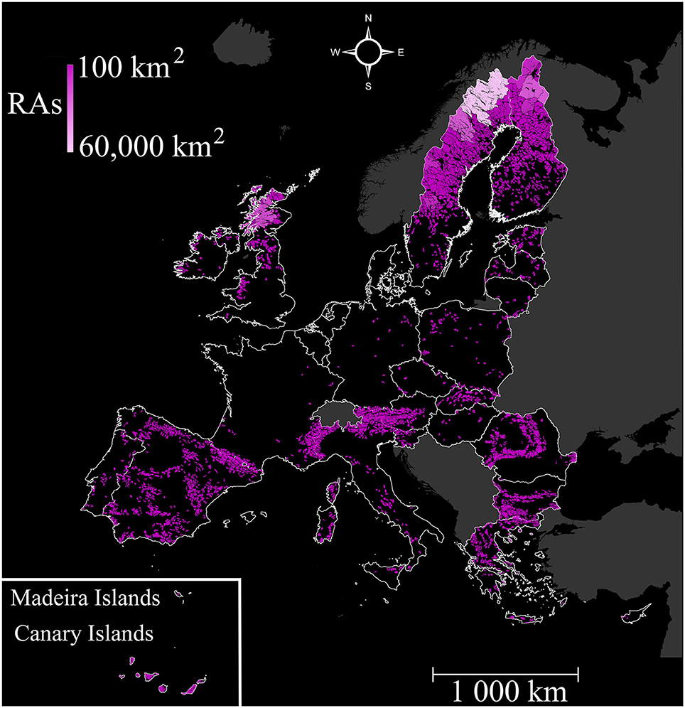
Figure 1. Distribution of Roadless Areas that are larger than 100 km2 (n = 1962 areas) in the territory of the European Union in 2014.
To identify RAs, we established a threshold distance of 1 km from the selected road system, and thus, exclude all “roaded” areas occurring within this distance, as they represent the zones most intensively disturbed by roads. Some studies have applied smaller threshold distances to identify RAs to examine road effects on specific taxa (Forman, 1997; Eigenbrod et al., 2009). However, given that the spatial extent of some road impacts is of several kilometers, the distance of 1 km is suggested as appropriate for analyses at the landscape level (Benítez-López et al., 2010; Freudenberger et al., 2013; Ibisch et al., 2016).
We used the CORINE Land Cover 2000 database (Copernicus Land Monitoring, Services, 2015) to identify landscape composition. CORINE Land Cover provides spatial information for Europe's land use cover categorizing it in five main classes: artificial surfaces, agricultural areas, forests and semi-natural areas, wetlands and water bodies (European Environmental Agency, 2014). For our analysis, we only retained areas that were classified as forests and semi-natural habitats or as wetlands (Selva et al., 2011; van der Ree et al., 2015). Other land cover classes, such as large water bodies, were not included since we were interested in identifying terrestrial RAs.
Applying the 1 km buffer mentioned above, we identified a large number of road-free patches (n = 358,249; covering ≈32% of the EU surface) which fulfill the land use criteria (Supplementary Figure 1). We assess the size distribution of RAs (≥1 km2). Then, we selected a threshold of 100 km2 to further identify RAs large enough to individually support effective biodiversity conservation and functional ecosystems (Joppa et al., 2008; Selva et al., 2011). This threshold has already been used in similar studies in order to define road-free areas in Germany and Czech Republic (e.g., Andĕl et al., 2005; Bundesamt für Naturschutz, Federal Agency for Nature Conservation, 2008; Selva et al., 2011). The distribution and size of RAs in the EU were quantified. Finally, we overlapped the maps of RAs and PAs (European Environmental Agency, 2012) to investigate the spatial relationship between RAs and the Natura 2000 sites. We calculated the surface of RAs that fell within the Natura 2000 network, and that was, therefore, protected, as well as the surface of RAs adjacent to Natura 2000 sites that could be added to the existing network of PAs (Supplementary Figure 2). All calculations were performed using GIS 10.1 (ArcGIS® software by ESRI).
Results
We identified 65,000 RAs which were equal or larger than 1 km2 (Supplementary Figure 1). However, the mean size of RAs ≥ 1 km2 was highly variable (mean: 20.7 ± 292 km2), and with a most frequent size of about 3 km2 (median: 3.3 km2). These RAs ≥ 1 km2, cover 31% of the terrestrial surface of the EU and were found throughout the EU, with many small RAs occurring in central Europe, while large RAs were mainly located on the periphery of the EU (e.g., northern Scandinavia, northern UK, Iberian Peninsula; Supplementary Figure 3).
The number of RAs decreased exponentially with increasing patch size (Figure 2, Supplementary Figure 1). We found that 1962 RAs were larger than 100 km2, covering 18.5% (793,287 km2) of the terrestrial surface of the EU. The largest RA was found in the border region of Sweden and Finland (covering 59,225 km2), followed by RAs occurring in northern Sweden, northern Finland, and northern UK (covering 21,410, 20,867, and 17,443 km2, respectively). The average surface of RAs larger than 100 km2 in the 27 studied countries was 404.3 km2 (SD: ±1632 km2). Sweden had the largest percentage of RAs in relation to its surface (55.9%), while Germany had one of the smallest percentages of RAs coverage (1.3%). We also found that the five smallest countries in Europe, namely Belgium, Denmark, Luxemburg, Malta, and the Netherlands, had no RAs larger than 100 km2 (Figures 1, 3, Supplementary Table 1). We identified a total of 174 transboundary RAs, which represented only 9% of the RAs identified, but 29% of the RAs surface (228,361 km2). On average, transboundary RAs were larger in size (mean ± SD: 1312 ± 5083 km2, median: 329 km2) than RAs within one country.
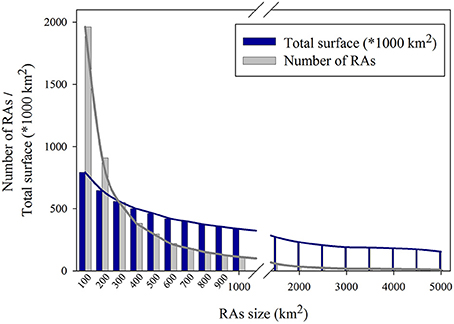
Figure 2. Size distribution of Roadless Areas that are larger than 100 km2 (n = 1962 areas) in the European Union territory in 2014.
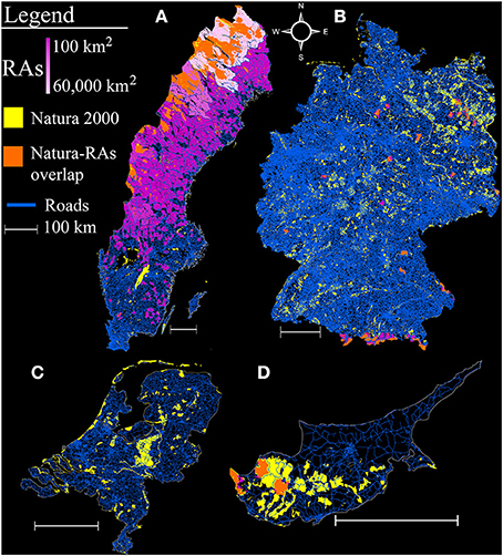
Figure 3. (A–D) Distribution of the Open Street Map road network (blue), Roadless Areas larger than 100 km2 (RAs, violet gradient) and Natura 2000 sites (yellow) in four EU countries: Sweden (A), Germany (B), the Netherlands (C), and Cyprus (D). The spatial overlap between RAs and Natura 2000 sites is indicated in orange.
The percentage of RAs surface that is currently protected within the Natura 2000 network is 35.5%. The degree of overlap between RAs and Natura 2000 sites highly varied across countries, ranging from 19.3% in Sweden to 89% in Cyprus. Interestingly, the three countries with the largest percentage of total RAs coverage (Sweden, Finland, and Austria) had the lowest overlap of RAs with Natura 2000 sites. These countries, along with the UK, could significantly expand their PAs network if RAs would be added (Supplementary Table 1, Supplementary Figure 4). The expansion of the network by adding adjacent RAs was minimum for Hungary and Poland (3% increase) and maximum for Sweden (310% increase; Supplementary Table 1). In general, the Natura 2000 network could be enlarged by 66% through the inclusion of adjacent RAs; this would mean that the total area of the EU dedicated to biodiversity conservation would reach 1276 thousand km2 then (~30% of EU's terrestrial surface).
Discussion
We proposed and tested a comprehensive framework for addressing the integration of RAs in Natura 2000, the established conservation network in the EU. First, we showed that RAs cover only 18.5% of EU territory and highly varied in size and geographical location; most roadless patches were very small in size. Second, we demonstrated that the enlargement of the EU conservation network could be achieved by designating RAs as protected sites, or by incorporating adjacent RAs into existing sites of the Natura 2000 network, which would increase the protected land up to almost 30% of EU's surface.
Transboundary regions contained many of the large RAs identified, while such large RAs are practically absent from central Europe. Though certain countries, like Germany and France, have effectively adopted EU environmental policies and fulfilled all their international nature conservation commitments (Égert, 2012), they are highly fragmented, which may compromise goals such as the ecological integrity of Natura 2000 sites (Selva et al., 2011). The intense land use and infrastructure development of most areas in central Europe since the eighteenth century is partly due to its low elevation and mild climatic conditions that have facilitated successful agriculture (Antrop, 2004). Europe is highly fragmented by transport infrastructure; half of the continent is within 1.5 km from a paved road or a railway line (Torres et al., 2016), thus, leaving not many remote areas that can be characterized as RAs (Figures 1, 3, Supplementary Figure 1). Fragmentation constrains the effectiveness of EU's conservation policies (Pullin et al., 2009) and, therefore, it is important to establish and promote measures that halt fragmentation and its impacts. Such measures include bundling of transport routes and the creation of wildlife corridors (van der Ree et al., 2015), and even the implementation of a principle of No-Net-Loss of unfragmented lands as a compensation measure (Selva et al., 2015). Similar measures have been recently identified, prioritized, and adopted by the EU Green Infrastructure strategy (Lafortezza et al., 2013). Landscape fragmentation caused by transport infrastructure may be only partially mitigated, and its impacts can be entirely avoided only in areas where roads are completely absent, i.e., by the protection and restoration of RAs (Laurance et al., 2014; IENE, 2015; Ibisch et al., 2016). There are already ~5 million km of roads in the EU (van der Ree et al., 2015), including the Trans-European Transport Network, which is planned to reach more than 170,000 km of road length by 2030 (Teodorovic and Janic, 2016; 75,000 km of roads in 2005; Tillmann, 2005). Given the magnitude of road expansion in the near future, with 25 million km of new roads in the world planned by 2050 (Laurance et al., 2014), RAs conservation should be a top priority at national, continental, and global scale (Selva et al., 2011; Laurance et al., 2014; Ibisch et al., 2016).
In many cases, PAs are located in remote or unproductive areas, which are inaccessible due to the lack of road infrastructure (Joppa and Pfaff, 2009). Their designation has prevented them from degradation caused by road impacts, thus, keeping them road-free. Nevertheless, there are cases of PAs where roads already existed and are retained to support local communities and tourism (Eagles et al., 2002). Although road development projects within the boundaries of PAs are usually limited, road removal is also an option to be seriously considered in cases of unneeded and ecologically damaging roads (Eagles et al., 2002; Selva et al., 2015). Road reclamation has an environmental impact as well; however, when combined with restoration treatments, it brings significant long-term benefits like a reduction in chronic erosion (Switalski et al., 2004). Large mammals and fish are also known to react positively to road reclamation, while vegetation and soils can develop more rapidly and sequester larger amounts of carbon when roads are decompacted during reclamation (Selva et al., 2015; van der Ree et al., 2015). Policy makers and land managers could use the results of this study to avoid further dissecting the existing RAs and determine potential targets for road optimization. Re-routing and/or removal of unneeded and ecologically damaging roads would also increase the size of RAs, and restore landscape-level connectivity. In cases of RAs which contain low-traffic roads, as the ones identified in this study, implementing speed and traffic volume limitations are also measures that could be considered in order to minimize road impacts (Selva et al., 2015).
The establishment of PAs systems aims at the conservation of species, habitats, and landscape-level processes and requires a careful identification and design process (Margules and Pressey, 2000). The designation of Natura 2000 sites is based on the presence of priority habitats and species; however, conservation targets should move from the traditional focus on species and habitats and consider more holistic approaches, which include ecosystem processes, functions, and integrity (Selva et al., 2011). In this sense, RAs represent a perfect proxy for ecosystem functionality; yet, this feature is not characteristic for most European PAs (Ibisch et al., 2016). The large variation in the percentage of RAs overlap with Natura 2000 sites across EU countries may also be indicative of the different criteria and methodological approaches applied during site designation (Palang et al., 2006).
In Europe, the designation of new PAs is needed to mitigate climate impacts to biodiversity and guarantee biological diversity persistence in the future (Araújo et al., 2011). The Habitats Directive sufficiency assessment, which was completed in 2013, concludes that not all EU member states reached their Natura 2000 targets and, therefore, further terrestrial PAs designations are needed (e.g., Cyprus, Austria, Slovakia; European Commission, 2016a). In combination with our study, this assessment could pinpoint cases where RAs prioritization could support conservation goals. For instance, the Natura 2000 network in Austria is considered to be far from complete (European Commission, 2016a), and RAs could support the Natura 2000 network's enlargement. However, in cases like Cyprus, where most RAs are already located within the Natura 2000 network (Figure 3, Supplementary Table 1), RAs could play only a minor role in future designations and conservation policies. Furthermore, the southern countries of the EU (e.g., Spain and Greece) are of particular conservation value, as the Mediterranean basin is a biodiversity hotspot of global importance (Myers et al., 2000), and still contain a considerable number of large RAs (Figure 1). In these biodiversity hotspots, RAs alone could be considered as a priority conservation target.
The integration of RAs with the Natura 2000 faces the same constraints as the establishment of any system of PAs, such as the needs of local communities (Alphandéry and Fortier, 2001) and the political will, which may not be concordant with the expansion of PAs (Grodzinska-Jurczak and Cent, 2011). However, this concept of conservation networks' enlargement has been supported by the EU 2020 biodiversity strategy, which includes for instance actions toward preserving wilderness areas (European Commission, 2011). The inclusion of wilderness areas in World Heritage Sites has also been proposed as a way to effectively protect their ecological integrity (Kormos et al, 2016). In addition, the actions included in the EU biodiversity strategy are supported by Article 10 of the Habitats Directive which calls member states to promote land-use planning and development policies that strengthen the coherence and resilience of the Natura 2000 network. Given the level of fragmentation in Europe (Torres et al., 2016; this study), RAs should be prioritized for additional protection in order to maintain landscape connectivity (Belote et al., 2016). Roadless areas, when added to existing PAs in the northern Rocky Mountains (USA), enhanced overall landscape connectivity by creating a larger and more cohesive system of PAs, by reducing isolation among PAs, and by creating a more dispersed PAs network, important for maintaining species movements (Crist et al., 2005). The conservation value of some PAs is currently at risk due to land use changes in surrounding lands (Martinuzzi et al., 2015) and protecting adjacent RAs may safeguard their values. Hence, we propose that RAs, as areas relatively undisturbed by humans, should be adopted as an alternative means of achieving the EU 2020 biodiversity strategy targets.
RAs protect biodiversity and ecosystem services, and are of particular importance in the context of climate change (Selva et al., 2011, 2015; van der Ree et al., 2015). The lack of large RAs reveals that wildlife distributions are at relatively close distances to transportation infrastructure, exposing wildlife to a number of threats (Torres et al., 2016). In this sense, mammals, in particular wide-ranging species like carnivores, would benefit from the protection and restoration of RAs (van der Ree et al., 2015; Torres et al., 2016). RAs also serve as barriers against invasive species (Strittholt and Dellasala, 2001; Selva et al., 2011), preserve the natural and semi-natural habitats of many species, and their genetic resources (Loomis and Richardson, 2000). Additionally, RAs help to stabilize the climate through carbon sequestration and nutrient cycling in forested areas (Loomis and Richardson, 2000; Selva et al., 2011, 2015) and provide multiple ecosystem services (e.g., provision of high quality water and air, erosion control, and recreational experiences; DellaSala et al., 2011). RAs sustain potential habitat suitable for a number of species and landscape-level connectivity between natural habitats, safeguarding native biodiversity (Crist et al., 2005; van der Ree et al., 2015; D'Amico et al., 2016; Torres et al., 2016).
Our study supports an innovative way to increase conservation capacity and efforts. RAs could enhance continental-scale connectivity, increasing overall coherence, and effectiveness of the Natura 2000 network. From a policy perspective, RAs represent a timely conservation tool to support EU nature conservation policies with minimum conflicts (i.e., EU 2020 Biodiversity Strategy, Green Infrastructure) and to achieve biodiversity conservation targets. Future studies should address fine or national scale assessments of RAs and their benefits to biodiversity, as well as the integration of RAs into nature conservation policy.
Authors Contributions
JP and AM conceived the study. NV, NS, and AM designed the analyses. MP and NV carried out data preprocessing, run the analyses, and were responsible for compiling the figures and tables. MP and NV lead writing with contributions from all authors. All five authors approve of this version to be published and agree to be accountable for this work in ensuring that questions related to the accuracy or integrity of any part of the work are appropriately investigated and resolved.
Funding
This publication was partially supported by the EU FP7 SCALES project (“Securing the Conservation of biodiversity across Administrative Levels and spatial, temporal and Ecological Scales”; project #226852) and by statutory funds of the Institute of Nature Conservation, Polish Academy of Sciences and the National Science Centre in Poland (2013/08/M/NZ9/00469).
Conflict of Interest Statement
The authors declare that the research was conducted in the absence of any commercial or financial relationships that could be construed as a potential conflict of interest.
Acknowledgments
NS acknowledges support from the Roadless Initiative of the Society for Conservation Biology-Europe section.
Supplementary Material
The Supplementary Material for this article can be found online at: http://journal.frontiersin.org/article/10.3389/fevo.2017.00002/full#supplementary-material
Abbreviations
PA, protected area; RA, roadless area.
Footnotes
1. ^Geofabrik GmbH and OpenStreetMap Contributors: Data/Maps. Available online at: http://download.geofabrik.de (accessed February 20, 2014).
References
Alphandéry, P., and Fortier, A. (2001). Can a territorial policy be based on science alone? The system for creating the Natura 2000 network in France. Soc. Ruralis 41, 311–328. doi: 10.1111/1467-9523.00185
Andĕl, P., Gorčicová, I., Hlaváč, V., Miko, L., and Andĕlová, H. (2005). Assessment of Landscape Fragmentation caused by Traffic. Systematic Guide. Prague: Agency for Nature Conservation and Landscape Protection of the Czech Republic.
Antrop, M. (2004). Landscape change and the urbanization process in Europe. Landscape Urban Plan. 67, 9–26. doi: 10.1016/S0169-2046(03)00026-4
Araújo, M. B., Alagador, D., Cabeza, M., Nogués-Bravo, D., and Thuiller, W. (2011). Climate change threatens European conservation areas. Ecol. Lett. 14, 484–492. doi: 10.1111/j.1461-0248.2011.01610.x
Belote, R. T., Dietz, M. S., McRae, B. H., Theobald, D. M., McClure, M. L., Irwin, G. H., et al. (2016). Identifying corridors among large protected areas in the united states. PLoS ONE 11:e0154223. doi: 10.1371/journal.pone.0154223
Benítez-López, A., Alkemade, R., and Verweij, P. A. (2010). The impacts of roads and other infrastructure on mammal and bird populations: a meta-analysis. Biol. Conserv. 143, 1307–1316. doi: 10.1016/j.biocon.2010.02.009
Brooks, T. M., Mittermeier, R. A., da Fonseca, G. A., Gerlach, J., Hoffmann, M., Lamoreux, J. F., et al. (2006). Global biodiversity conservation priorities. Science 313, 58–61. doi: 10.1126/science.1127609
Bundesamt für Naturschutz, Federal Agency for Nature Conservation (2008). Nature Data 2008. Bonn: BfN.
Butchart, S. H., Walpole, M., Collen, B., Van Strien, A., Scharlemann, J. P., Almond, R. E., et al. (2010). Global biodiversity: indicators of recent declines. Science 328, 1164–1168. doi: 10.1126/science.1187512
Čizmić, I., and Dragosavac, V. (2010). “Traffic volume estimation on regional road network in the Republic of Serbia,” in Proceedings of 10th Slovenian Congress on Roads and Transport (10. Slovenski Kongres O Cestah In Prometu) (Ljubljana: DRC - Society for Research in road and transport pods Slovenia)
Copernicus Land Monitoring, Services (2015). CORINE Land Cover. European Environmental Agency, Copenhagen, Denmark. Available online at: http://land.copernicus.eu/pan-european/corine-land-cover (Accessed November 12, 2015)
Crist, M. R., Wilmer, B., and Aplet, G. H. (2005). Assessing the value of roadless areas in a conservation reserve strategy: biodiversity and landscape connectivity in the northern Rockies. J. Appl. Ecol. 42, 181–191. doi: 10.1111/j.1365-2664.2005.00996.x
D'Amico, M., Périquet, S., Román, J., and Revilla, E. (2016). Road avoidance responses determine the impact of heterogeneous road networks at a regional scale. J. Appl. Ecol. 53, 181–190. doi: 10.1111/1365-2664.12572
DellaSala, D. A., Karr, J. R., and Olson, D. M. (2011). Roadless Areas and clean water. J. Soil Water Conserv. 66, 78A–84A. doi: 10.2489/jswc.66.3.78A
Department for Transport (Dft), UK (2016). Road Traffic Statistics: Average Annual Daily Flow and Temporal Traffic Distributions (TRA03). London. Available online at: https://www.gov.uk/government/statistical-data-sets/tra03-motor-vehicle-flow (Accessed December 20, 2016)
DeVelice, R. L., and Martin, J. R. (2001). Assessing the extent to which roadless areas complement the conservation of biological diversity. Ecol. Appl. 11, 1008–1018. doi: 10.1890/1051-0761(2001)011[1008:ATETWR]2.0.CO;2
Donald, P. F., Sanderson, F. J., Burfield, I. J., Bierman, S. M., Gregory, R. D., and Waliczky, Z. (2007). International conservation policy delivers benefits for birds in Europe. Science 317, 810–813. doi: 10.1126/science.1146002
Eagles, P. F., McCool, S. F., and Haynes, C. D. (2002). Sustainable Tourism in Protected Areas: Guidelines for Planning and Management. Gland; Cambridge: IUCN.
Égert, B. (2012). “France's environmental policies: internalising global and local externalities,” in CESifo Working Papers (Munich).
Eigenbrod, F., Hecnar, S. J., and Fahrig, L. (2009). Quantifying the road effect zone: threshold effects of a motorway on anuran populations in Ontario, Canada. Ecol. Soc. 14, 24. doi: 10.5751/ES-02691-140124
European Environmental Agency (2012). Natura 2000 Data - the European Network of Protected Sites (Version 2012). Brussels: Directorate-General for Environment (DG ENV). Available online at: http://www.eea.europa.eu/data-and-maps/data/natura-2 (Accessed January 20, 2013).
European Environmental Agency (2014). Corine Land Cover 2000 Seamless Vector Data (Version 2014). Copenhagen: European Environmental Agency. Available online at: http://www.eea.europa.eu/data-and-maps/data/corine-land-cover-2000-clc2000-seamless-vector-database-5 (Accessed November 12, 2015.)
European Commission (2011). “Communication from the Commission to the European Parliament, the Council, the Economic and Social Committee and the Committee of the Regions,” in Our Life Insurance, Our Natural Capital: An EU Biodiversity Strategy to 2020, 1–16.
European Commission (2016a). Natura 2000 Barometer-Update December 2015, Natura 2000 Newsletter (ISSN: 2443-7727). Brussels. Available online at: http://ec.europa.eu/environment/nature/info/pubs/docs/nat2000newsl/nat40_en.pdf
European Commission (2016b). “Fitness Check of the EU Nature Legislation (Birds and Habitats Directives): Directive 2009/147/EC of the European Parliament and of the Council of 30 November 2009 on the conservation of wild birds and Council Directive 92/43/EEC of 21 May 1992 on the conservation of natural habitats and of wild fauna and flora,” in Commission Staff Working Document (Brussels: European Commission). Available online at: http://ec.europa.eu/environment/nature/legislation/fitness_check/docs/nature_fitness_check.pdf
Evans, D. (2012). Building the European Union's Natura 2000 network. Nature Conserv. 1, 11. doi: 10.3897/natureconservation.1.1808
Forman, R. (1997). Land Mosaics: The Ecology of Landscape and Regions. New York, NY: Cambridge University Press.
Freudenberger, L., Hobson, P. R., Rupic, S., Pe'er, G., Schluck, M., Sauermann, J., et al. (2013). Spatial road disturbance index (SPROADI) for conservation planning: a novel landscape index, demonstrated for the State of Brandenburg, Germany. Landscape Ecol. 28, 1353–1369. doi: 10.1007/s10980-013-9887-8
Gamero, A., Brotons, L., Brunner, A., Foppen, R., Fornasari, L., Gregory, R. D., et al. (2016). Tracking Progress towards EU biodiversity strategy targets: EU policy effects in preserving its common farmland birds. Conserv. Lett. doi: 10.1111/conl.12292. (accepted manuscript).
Grodzinska-Jurczak, M., and Cent, J. (2011). Expansion of nature conservation areas: problems with Natura 2000 implementation in Poland? Environ. Manage. 47, 11–27. doi: 10.1007/s00267-010-9583-2
Ibisch, P. L., Hoffmann, M. T., Kreft, S., Pe'er, G., Kati, V., Biber-Freudenberger, L., et al. (2016). A global map of roadless areas and their conservation status. Science 354, 1423–1427. doi: 10.1126/science.aaf7166
IENE (2015). Protect remaining roadless areas: the IENE 2014 declaration. Nature Conserv. 11, 1–4. doi: 10.3897/natureconservation.11.5630
Iuell, B., Bekker, G. J., Cuperus, R., Dufek, J., Fry, G., Hicks, C., et al. (2003). Wildlife and Traffic: a European Handbook for Identifying Conflicts and Designing Solutions. Utrecht: KNNV Publishers.
Jenkins, C. N., and Joppa, L. (2009). Expansion of the global terrestrial protected area system. Biol. Conserv. 142, 2166–2174. doi: 10.1016/j.biocon.2009.04.016
Joppa, L. N., Loarie, S. R., and Pimm, S. L. (2008). On the protection of “protected areas”. Proc. Natl. Acad. Sci. U.S.A. 105, 6673–6678. doi: 10.1073/pnas.0802471105
Joppa, L. N., and Pfaff, A. (2009). High and far: biases in the location of protected areas. PLoS ONE 4:e8273. doi: 10.1371/journal.pone.0008273
Jordan, A. (2005). Environmental Policy in the European Union: Actors, Institutions, and Processes. London: Earthscan.
Kati, V., Hovardas, T., Dieterich, M., Ibisch, P. L., Mihok, B., and Selva, N. (2015). The challenge of implementing the European network of protected areas Natura 2000. Conserv. Biol. 29, 260–270. doi: 10.1111/cobi.12366
Kormos, C. F., Bertzky, B., Jaeger, T., Shi, Y., Badman, T., Hilty, J. A., et al. (2016). A wilderness approach under the world heritage convention. Conserv. Lett. 9, 228–235. doi: 10.1111/conl.12205
Lafortezza, R., Davies, C., Sanesi, G., and Konijnendijk, C. C. (2013). Green Infrastructure as a tool to support spatial planning in European urban regions. iFor. Biogeosci. For. 6, 102. doi: 10.3832/ifor0723-006
Laurance, W. F., Clements, G. R., Sloan, S., O'Connell, C. S., Mueller, N. D., Goosem, M., et al. (2014). A global strategy for road building. Nature 513, 229–232. doi: 10.1038/nature13717
Loomis, J., and Richardson, R. (2000). Economic Values of Protected Roadless Areas in the United States. Prepared for the Wilderness Society and Heritage Forests Campaign. Washington, DC: The Wilderness Society.
Margules, C. R., and Pressey, R. L. (2000). Systematic conservation planning. Nature 405, 243–253. doi: 10.1038/35012251
Martinuzzi, S., Radeloff, V. C., Joppa, L. N., Hamilton, C. M., Helmers, D. P., Plantinga, A. J., et al. (2015). Scenarios of future land use change around United States' protected areas. Biol. Conserv. 184, 446–455. doi: 10.1016/j.biocon.2015.02.015
Mazaris, A. D., Papanikolaou, A. D., Barbet-Massin, M., Kallimanis, A. S., Jiguet, F., Schmeller, D. S., et al. (2013). Evaluating the connectivity of a protected areas' network under the prism of global change: the efficiency of the european natura 2000 network for four birds of prey. PLoS ONE 8:e59640. doi: 10.1371/journal.pone.0059640
Myers, N., Mittermeier, R. A., Mittermeier, C. G., Da Fonseca, G. A., and Kent, J. (2000). Biodiversity hotspots for conservation priorities. Nature 403, 853–858. doi: 10.1038/35002501
Neis, P., and Zipf, A. (2012). Analyzing the contributor activity of a volunteered geographic information project—The case of OpenStreetMap. ISPRS Int. J. Geo-Inf. 1, 146–165. doi: 10.3390/ijgi1020146
Nie, M., and Barns, C. (2014). Fiftieth Anniversary of the Wilderness Act: The Next Chapter in Wilderness Designation, Politics, and Management. Ariz. J. Envtl. Law Pol. 5, 237.
Palang, H., Printsmann, A., Gyuró, É. K., Urbanc, M., Skowronek, E., and Woloszyn, W. (2006). The forgotten rural landscapes of Central and Eastern Europe. Landscape Ecol. 21, 347–357. doi: 10.1007/s10980-004-4313-x
Pimm, S. L., Jenkins, C. N., Abell, R., Brooks, T. M., Gittleman, J. L., Joppa, L. N., et al. (2014). The biodiversity of species and their rates of extinction, distribution, and protection. Science 344:1246752. doi: 10.1126/science.1246752
Pullin, A. S., Báldi, A., Can, O. E., Dieterich, M., Kati, V., Livoreil, B., et al. (2009). Conservation focus on Europe: major conservation policy issues that need to be informed by conservation science. Conserv. Biol. 23, 818–824. doi: 10.1111/j.1523-1739.2009.01283.x
Rodrigues, A. S., Andelman, S. J., Bakarr, M. I., Boitani, L., Brooks, T. M., Cowling, R. M., et al. (2004). Effectiveness of the global protected area network in representing species diversity. Nature 428, 640–643. doi: 10.1038/nature02422
Selva, N., Kreft, S., Kati, V., Schluck, M., Jonsson, B.-G., Mihok, B., et al. (2011). Roadless and low-traffic areas as conservation targets in Europe. Environ. Manage. 48, 865–877. doi: 10.1007/s00267-011-9751-z
Selva, N., Switalski, A., Kreft, S., and Ibisch, P. L. (2015). “Why keep areas road-free? The importance of roadless areas,” in Handbook of Road Ecology, eds R. van der Ree, D. J. Smith, and C. Grilo (Western Sussex: John Wiley and Sons), 16–26. doi: 10.1002/9781118568170.ch3
Strittholt, J. R., and Dellasala, D. A. (2001). Importance of roadless areas in biodiversity conservation in forested ecosystems: case study of the klamath-siskiyou ecoregion of the united states. Conserv. Biol. 15, 1742–1754. doi: 10.1046/j.1523-1739.2001.99577.x
Switalski, T. A., Bissonette, J. A., DeLuca, T., Luce, C., and Madej, M. (2004). Benefits and impacts of road removal. Front. Ecol. Environ. 2, 21–28. doi: 10.1890/1540-9295(2004)002[0021:BAIORR]2.0.CO;2
Teodorovic, D., and Janic, M. (2016). Transportation Engineering: Theory, Practice and Modeling. Oxford: Butterworth-Heinemann, Elsevier.
Torres, A., Jaeger, J. A., and Alonso, J. C. (2016). Assessing large-scale wildlife responses to human infrastructure development. Proc. Natl. Acad. Sci. U.S.A. 113, 8472–8477. doi: 10.1073/pnas.1522488113
van der Ree, R., Jaeger, J. A., van der Grift, E. A., and Clevenger, A. P. (2011). Effects of roads and traffic on wildlife populations and landscape function: road ecology is moving toward larger scales. Ecol. Soc. 16:48. doi: 10.5751/ES-03982-160148
van der Ree, R., Smith, D. J., and Grilo, C. (2015). Handbook of Road Ecology. Western Sussex: John Wiley and Sons.
Keywords: road-free areas, road system, green infrastructure, integrated biodiversity policy, EU 2020 biodiversity targets, protected areas
Citation: Psaralexi MK, Votsi N-EP, Selva N, Mazaris AD and Pantis JD (2017) Importance of Roadless Areas for the European Conservation Network. Front. Ecol. Evol. 5:2. doi: 10.3389/fevo.2017.00002
Received: 07 November 2016; Accepted: 16 January 2017;
Published: 02 February 2017.
Edited by:
Clara Bentes Grilo, Universidade Federal de Lavras, BrazilReviewed by:
Tom Langen, Clarkson University, USAFei Wang, Institute of Soil and Water Conservation (CAS), China
Copyright © 2017 Psaralexi, Votsi, Selva, Mazaris and Pantis. This is an open-access article distributed under the terms of the Creative Commons Attribution License (CC BY). The use, distribution or reproduction in other forums is permitted, provided the original author(s) or licensor are credited and that the original publication in this journal is cited, in accordance with accepted academic practice. No use, distribution or reproduction is permitted which does not comply with these terms.
*Correspondence: Maria K. Psaralexi, mpsarale@bio.auth.gr; mpsarale@gmail.com