 Luciana Travassos
 Sandra Momm
- Center for Science, Technology and Society, Federal University of ABC, São Paulo, Brazil
The paper aims to discuss the sociotechnical transitions regarding urban rivers policy in São Paulo Municipality by focusing on programs and projects conducted since 2000. Accordingly, we use a theoretical reflection on sociotechnical transitions and just transitions in interventions related to water and cities. Our work is based on a documental analysis of programs and projects for urban rivers in the municipality conducted via theoretical discussion. The primary focus is on the current sociotechnical regime, the channeling of streams and construction of road systems on its banks, and disputes and pressures brought by the technological landscape and niches, which lead to the construction of linear parks and leisure areas along with the bodies of water. It also shows how the issue of justice has been losing ground in this transition, which although is “in the making,” already presents many factors of injustice. This is due to the low presence of the theme of precarious settlements, in innovative speeches and practices, and the different treatment given by the programs and projects for rivers in the consolidated middle- and upper-class regions and for those located on the peripheries.
Introduction
The paper aims to discuss the sociotechnical transitions in urban river policy in the Municipality of São Paulo by focusing on programs and projects carried out since 2000. The proposals for urban rivers from 2000 to the present have been representing an inflection over the standard practices of the 20th century; however, it has been done without continuity and with disruptions along with incomplete projects and interventions. Thus, the article analyzes the advances and barriers of this transition—as well as its characteristics—by considering the context of Brazil's largest city. Furthermore, it contributes to the theoretical debate on sociotechnical transitions to water management-related infrastructures and the debate on transitions in the cities of peripheral countries.
São Paulo is located in the headwaters of the Tietê River Basin. The site has a complex hydrological network, with more than ~1,500 km of small streams arranged in a dense dendritic form. In urban areas, it is possible to find closed as well as open-channeled rivers, but notably, rivers running almost naturally through precarious settlements are the prevalent ones. Less common, but also present, are some river parks, which are called linear parks.
Historically, the urban rivers' margins in São Paulo City have been used to provide space for avenues and transportation infrastructure. The debates on the urbanization of river valleys at the beginning of the 20th century have resulted in a paradigm that associates the construction of avenues with the channeling of streams. First, this binomial was part of a structural avenue's plans, but later, especially after 1970, it became part of urban improvement programs. Yet, flooding and water degradation problems were not solved by these interventions.
Since the 1980s, this paradigm has been questioned by a wide range of researchers, environmentalists, and technicians from the city hall. This resulted in the beginning of a sociotechnical transition, with the widening of institutions and actors who think and propose these policies, programs, and interventions in the floodplains and rivers. This effort has considered new perspectives on technologies, especially ones aiming to build a different relationship between the rivers and the city through the proposal of projects and elements that can be configured as green infrastructure. But, by the middle of the last decade, it had lost its force in public policies and things quickly went back to the old paradigm.
As a theoretical basis for the case being studied, the use of the transition literature is relevant to shed light on how certain paradigms, ideas, and proposals associated with sustainability are (or are not) implemented (Markard et al., 2020). In a political technical naïve view, sustainability is not achieved by a lack of understanding of the long-term economic and collective benefits. Hence, the efforts to the present, at each new regulatory framework or international platform (e.g., climate change), there are new conceptual approaches, instruments, and techniques suggested with the hope of changing the path dependence. However, the non-implementation is due to—among other factors—a web of interests and resistance associated with a political context (interests of groups and actors) and also to a sociotechnical panorama making it difficult to deviate from mainstream practice (Geels and Schot, 2007). Considering climate change as a driver, the transition literature has been mainly incorporated to the theme of energy, but not so much with regard to water (García Soler et al., 2018).
Moreover, the use of this literature also has limits, one of which comes from its European origin and the great difference between the context in which it was developed and the reality of countries like Brazil. Another limitation, still associated with the first, involves environmental justice, or how these changes in the patterns of infrastructure and planning mainly occur in valued areas and drive inequality and gentrification. In this sense, it is important to put together sociotechnical transition and just transition literature and to confront both with case studies in peripheral countries.
The methodology is organized on the two following main bases: first, the literature review was conducted on sociotechnical transition and the sociotechnical transition associated with drainage infrastructures. Then, another specific review was conducted on just transition, which also covered texts that relate sociotechnical transition to a broader concept of justice. The reviews are based on the Scopus platform searching; also, the selection of the bibliography used was made by content and narrative adherence. At this moment, it is appropriate to point out that this last review was not intended to cover the whole debate on environmental justice, but rather how the idea of justice has been understood within the analyses concerning transition. The theme of Just Transition is still little covered in the literature; thus, this paper also seeks to contribute to this dimension of transitions.
The discussion on the sociotechnical transition in the policies for urban rivers in the city of São Paulo was mainly based on documental analysis, and it is detailed in section Material and Methods of this paper.
Structurally, the paper is organized into four parts besides this introduction. First, the theoretical basis is organized into two parts: terms and concepts from the founding literature of transitions and urban waters and the theme of just transitions. Then, in section Material and Methods, we detail the documents used and how they were searched and analyzed. Finally, we present and discuss the results. First the spatial configurations of urban rivers in the city are briefly presented, finally leading to the detailing of the policies, programs, and projects for urban rivers throughout the 21st century. The article shows that there is a sociotechnical transition “in the making” with some results in changes in the way of thinking and intervening in urban rivers, but these practices do not expressively consider a fair distribution in the city. The maintenance of this new trajectory should contribute to maintaining and even increasing the deep spatial inequality that exists.
Transitions, Cities, and Water
The term “transition” has been gaining ground in plans and policies related to sustainability. In the academic field, the term “sociotechnical transitions” emerged in the early 2000s in innovation studies (Newell and Mulvaney, 2013; Geels, 2019). Specifically, Geels and Schot (2007) define transitions as changes from one sociotechnical regime to another. “The sociotechnical regime concept accommodates this broader community of social groups and their alignment of activities” (Geels and Schot, 2007, p. 399). This refers to deep structural changes in systems such as energy “that involve long-term and complex reconfigurations of landscapes with technology, policy, infrastructure, scientific knowledge, and social and cultural practices toward sustainable ends” (Newell and Mulvaney, 2013, p. 133).
The Multi-Level Perspective (MLP) is a framework (Geels and Schot, 2007; Geels, 2019) used to understand the process of innovation and sociotechnical transition on an interrelated three-level framework of landscape (macro), regime (meso), and niche (micro) (Hodson and Marvin, 2010). Landscape level refers to pressure and driving forces in a broader context that do or do not create conditions to innovations and affect; accordingly, it is affected by the forces from the regimes and niches. For Geels and Schot (2007, p. 400) “changes at the landscape level usually take place slowly (decades).” Regarding niches, these authors point out that “Technological niches from the micro-level where radical novelties emerge. These novelties are initially unstable sociotechnical configurations with low performance. Niche-innovations are carried and developed by small networks of dedicated actors, often outsiders or fringe actors.” (Geels and Schot, 2007, p. 400). Although the three levels are closely related, there is a debate as to whether innovations necessarily emerge from niches or whether they are a response to landscape and regime pressures from an adaptive perspective (Hodson and Marvin, 2010).
Another important point is the role of places for transitions, especially that of cities in urban sociotechnical transitions (Hodson and Marvin, 2010; García Soler et al., 2018). “A series of economic, ecological, population and institutional constraints have produced new challenges and pressures on urban growth and to the management of cities' critical infrastructures.” (Hodson and Marvin, 2010, p. 477). These authors point out that evaluating urban transition also involves considering that it is intertwined with a web of networks, and therefore, we must consider various scales of governance or multilevel governance.
The work of Hodson and Marvin (2010) addresses the role of cities and socio-technical transitions. Between 2006 and 2009, they analyzed London, New York, Tokyo, San Francisco, and Melbourne and concluded that there is evidence, in these large cities, of deliberate attempts to reconfigure the sociotechnical systems in the proposals and implementation of infrastructure. For these authors “in a period of resource constraint and climate change, the world's largest cities are beginning to translate their strategic concern about their ability to guarantee resources into strategies designed to reshape the city and its relations with resources and other spaces” (p. 478). However, they highlight the context of disputes over urban territorial priorities in which political elites seek to gain degrees of control over the organization and management of energy, water, waste, and transportation infrastructures. This aspect develops in what will be discussed below about just transitions. In addition to intranational inequalities, Hodson and Marvin (2010) point to the necessary research efforts that “engage with transitions in cities outside of premium world cities and examine what transitions look like in ordinary cities and cities of the global south.” This is an aspect that will be, in an exploratory way, developed in the case of São Paulo (Brazil).
The work of (García Soler et al. 2018) involves a long-term analysis of the policies and projects implemented to promote rainwater harvesting in Berlin. Subsequently, it is a contribution to the theme of transitions and urban waters. They reason about the need for exploring the topic of how the city is molded by the transitions. The authors “used the Berlin experience to challenge conventional models of linear transition pathways and sensitize scholars to the messiness of urban water management trajectories, which can involve reversals, diversions and sudden leaps” (García Soler et al., 2018, p. 105).
In Brazil, much of the literature on macro and micro drainage has an approach that disregards these elements and focuses on stricto sensu aspects of the components of hydrology and their scientific expressions. Even from an integrated water and sanitation management perspective, and the regulatory frameworks of the last decade of the last century and the first of this century, there is still a focus on sectoral and technical approaches as responses to problems in this field. It is common to find terms like “lack of [urban or metropolitan] planning” to justify countless factors that hinder and even prevent more advanced solutions from being implemented. In contrast, the growing literature on green infrastructure, solutions based on nature, and those linked to social actions such as civic ecology and insurgents have brought new possibilities to the theme—but still without the proper scale and scope (Momm et al., 2020), as we will see in the case studied.
Just Transition
The analysis of the sociotechnical transition must be accompanied by the following key issue in peripheral and extremely unequal countries: justice. Routledge et al. (2018) understand that the possibilities of guaranteeing sustainable and fair futures fail because the essential resources and the production of knowledge are managed by elites in sociotechnical regimes committed to maintaining the status quo.
If it is climate change that pressures the transition, these same authors deeply criticize the guidelines developed at the Paris Conference, as they understand that they are based on neoliberal foundations of governance, since it does not address inequalities and does not confront issues of interest to the private sector, like free markets, and are also quite restricted to the possibilities of each nation-state. Thus, they understand that such goals do not address policies to reduce inequality which between nations and even within them results in an unequal distribution of vulnerabilities and possibilities to deal with climate change, including in terms of political participation. In extremely unequal countries, these dimensions of inequality occur within the same city (Canil et al., 2020; Torres et al., 2020). Although inequality can lead to social participation in the construction of public policies, analyzing the relationship between participation and inequality complex (Gaventa and Martorano, 2016), through the outcomes it is possible to highlight the maintenance of inequalities. In other words, inequality of participation contributes to the construction of unequal policies.
Newell and Mulvaney (2013) agree with the hole of the elites in shaping the policies to their interest, especially because the political economy of global environmental justice is characterized by uneven power relations, conflict, and often violence. Also, the interests of global elites are more often than not misaligned with the needs and environmental vulnerabilities of the world's poorest people. In this context, they intend to “emphasize the ways in which uneven exposure to environmental benefits and harm is often not accidental and unintentional, but rather a product of a particular way of organizing production and its constitutive social relations” (Newell and Mulvaney, 2013, p. 133).
Then, there is the term “transition,” which has been increasingly used in public plans and policies related to a low-carbon economy. It needs to be extended to a broader sustainability perspective and accomplished by the term, justice. To Newell and Mulvaney (2013), there is an increasing recognition that the politics of transition have to ensure that the proposed policies are socially just and that they address environmental inequalities in terms of exposure to localized degradation. Furthermore, the actions taken to alleviate global or regional environmental threats cannot reproduce the inequalities at local levels.
Heffron and McCauley (2018) debate the concept of a just transition, to put together these three existing justice approaches in the literature: energy justice, climate justice, and environmental justice. They consider that there is a distortion, especially in the traditional economic literature, on the attempts of achieving a just transition within societies in time and space. They argue that justice needs a global and human rights perspective, rather than a local and civil rights one, and the just transition concept has the advantage to engage all three justice stakeholders—especially in overcoming inequalities. Also, the authors build the “Just Framework” to be applied to just transition. In this framework, they proposed the four dimensions of Justice, Universal, Space, and Time. The first recovers the three types of justice: distributional, procedural, and restorative; Universal deals with recognition and cosmopolitanism; Space focuses on the places where the events are happening; last but not least, Time brings the horizons to transition, short, medium, or long-term. Specifically, the idea is to combat the status quo in research and practice (Heffron and McCauley, 2018).
Similarly, Fitzgibbons and Mitchell (2019) argue that recognition, redistribution, and participation are three essential dimensions of justice in planning processes and outcomes. Through them, they propose an analysis of the Rockefeller Foundation's 100 Resilient Cities initiative using two broad dimensions: Open Process and Recognitional and Distributive Justice. They discovered that “resilience thinking, in practice, supports the status quo.” The reason is that, in the first place, the overcoming of the structural inequalities is not considered in the program or the majority of the proposals received. So, these three main issues are linked to the dimension mentioned: the concentration of experiences in cities in central countries; the insufficient space for communities to participate in decisions linked to projects; and the existence of acts of omission and commission, established from another important work that analyzes adaptation plans, by Anguelovski et al. (2016).
The categories of acts of omission and acts of commission are important references to assess the relationship between resilience and environmental justice and can be mobilized to sociotechnical transition issues. Based on reading that many of the adaptation plans increased social inequalities, Anguelovski et al. (2016) sought to establish categories that report the dimensions of the plans and their resulting inequality. They are classified as acts of omission when inequality is caused indirectly, for example, when there is a choice to prioritize richer communities for the implementation of infrastructure or when the poorest part of a given community is not engaged in the construction of proposals. The acts of commission result from a direct action of the plan, which produces or reproduces inequalities. An example of one of these equalities is removal actions, the relocation to places in worse urban conditions, or even the gentrification processes generated by the development of infrastructure.
It is possible to summarize these dimensions by the 5 W's proposed by Meerow and Newell (2016) to put in the center of the agenda the recognition of politicized decisions, scalar dimensions, and trade-offs of resilience plans which leads to the analysis of justice within them. Between other questions, they inquired about the following: who defines and who is excluded by the plans; what sectors and networks are included and what disturbances are focused; regarding the “when” questions, if the plans have short- or long-term horizons; where is the resilience prioritized and if this focus undermined the resilience elsewhere; and why were some goals defined to resilience plans.
Finally, we highlight that regarding the lack of investments in infrastructure in the cities of peripheral countries, the State has a fundamental role to play in the transition, but also it has a fundamental role to play in just transition. Routledge et al. (2018, p. 79) claim that the state is “a continued terrain of possibility for positive social, economic, and environmental change, noting the imperative of historically attentive state-enabled redistribution along persistent axes of difference.” This emphasizes the large cities where strategic transition projects can be held by supportive state actors and civil society groups (Routledge et al., 2018).
Materials and Methods
The methodology that was utilized for the empirical analysis was documental research. Certain documents were gathered which covered over 25 years of research—including master and doctoral researches—and are detailed in the academic presentation (Travassos, 2004, 2010). It consisted of a historical retrieval of speeches, plans, programs, and projects related to urban rivers in the Municipality of São Paulo. The speeches were collected in specialized magazines and newspapers (e.g., Revista de Engenharia or Construção São Paulo) or of wider circulation, from the collection of the newspaper O Estado de São Paulo. From articles and reports, it was possible to analyze how the experts and the public opinion considered what should be done with São Paulo's rivers. The second set of documents were the plans, programs, and projects existing in the collections of the main public agencies that planned and intervened in urban rivers. At the municipal level, the documents were consulted in the secretariats that are now called the Municipal Secretariat of Urban Infrastructure and the Municipal Secretariat of Urban Planning and Licensing. At the state level, and with special emphasis on the post-1970s period, at the now-extinct São Paulo Metropolitan Planning Company, Emplasa, there was a wealth of documentation on the urban drainage problems of the Upper Tietê River Basin and debates on possible solutions. The analysis emphasized the Master Plan concerning drainage and linear parks projects; moreover, it also relied on texts that analyze specific aspects of these policies. Extensive documentation was also gathered from the Central Library of the Polytechnic School and the School of Architecture and Urbanism of the University of São Paulo, which keep archives of many urban and sanitation plans. The first one is concentrated on information, especially up to the 1930s and 1940s; the second one is focused on posterior documents.
All documents were read thoroughly, and we extracted information from them concerning the actors, institutions, discourses, and proposals for urban rivers, as well as prioritized rivers and watersheds. From there, it was possible to understand the consolidation, permanence, and rupture of intervention practices in urban rivers and to establish three important moments of the constitution of sociotechnical regimes. The first, established around the 1930s, was configured by the canalization of streams and the construction of valley bottom avenues. This was done via projects that comprised road plans for the city. The second, starting in the mid-1970s, still repeats the pattern of valley bottom avenues and open or gallery canalization—now disconnected from road plans—composing improvement programs; thus, where there was a stream, it would be canalized and would give way to a road. The third period, on which this article is focused, is configured by the questioning of this binomial: stream canalization and construction of valley bottom avenues, which gives rise to other forms of intervention and the growth of the debate on linear parks and the renaturalization or recovery of waterways.
This documental analysis was combined with a reflexive practice from the authors, mainly in the urban drainage plans of the São Paulo Municipality, during the years 2013 through 2014 and at the Alto Tiete River Basin Committee since 2017.
For the last years, documents from the websites of the municipal government (for the amount and typology of ongoing and recently completed works) and state government, especially the page of the Novo Rio Pinheiros project and the Sanitation Company of the State of São Paulo, Sabesp, were used. We also conducted a brief survey on news portals using Google's advanced search machine, to verify the presence of urban rivers and the most commonly cited problems, in order to understand if and how the topic has grown in recent years, with a special focus on discourses about channeled gallery rivers. A similar search on Google Scholar was used to confront the criticism that has been made about São Paulo's urban rivers, focusing on the observation of the discourse about the gallery-channeled rivers in relation to the peripheries. For the present paper, some important documents that represent the changes and continuities of the regime were selected.
Urban Rivers in São Paulo
The São Paulo Municipality is the capital of the State and the Metropolitan Region of São Paulo. It has an area of 1.5 km2, an urban area that occupies two-thirds of it, and a population of 12.3 million people. Despite having the highest GDP per capita in Brazil, about 31% of its inhabitants live on an income below half a minimum monthly wage, an amount equivalent to < $100 per capita, according to data from March 2021. Among urban households, only 50.3% have adequate urbanization infrastructure, such as drainage and paving (Instituto Brasileiro de Geografia e Estatística., 2021).
São Paulo is located in the vicinity of the spring of its main water body, the Tietê River, a destination of the vast majority of water bodies in its territory. There is an exception regarding a small stretch of the basin, at the southern end, which flows into the ocean (Figure 1). During its passage through the city, this river and also its main tributary, the Rio Pinheiros, present a very low slope, which means that, in its natural structure, forms a series of meanders and occupies an enormous floodplain, which was gradually occupied while the rivers were being rectified. However, their tributary rivers have greater energy. They are configured in small watersheds, with greater slopes and a great amplitude between the base and flood flows, thus forming a dense dendritic network of small streams. These differences are fundamental to understanding the drainage node in the city, as floods configured as flash floods have always characterized the processes of rising water and drainage plans and projects over time. So, instead of mitigating this situation, they have intensified it.
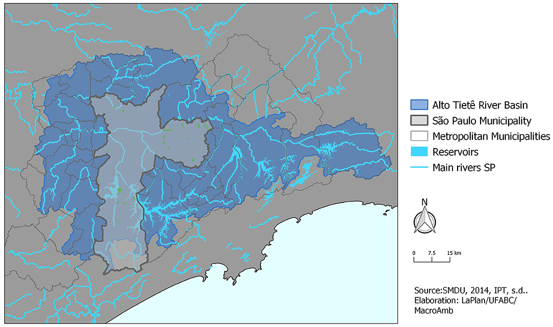
Figure 1. São Paulo municipality at Alto Tietê River basin.
In the São Paulo Municipality, there are currently four spatial configurations of urban rivers. These configurations are closely related to the time frame of public policies throughout the 20th and early 21st centuries, as shown by Travassos (2004, 2010). Notably, rivers channeled into closed galleries are the oldest of them, the result of a practice that was established in the 1930s and lasted for about 50 years (Figure 2). During those decades, the covering of rivers was required by the population and supported by the logic present in sanitation and road engineering. Thus, it was a practice that, in the view of that particular time, made it possible to clean up the city and represented an opportunity to support the construction of the structural system of avenues. Newspaper reports (Porchat, 1920; Prado, 1936; Estado de São Paulo, 1962, 1984; A Construção São Paulo, 1972), urban plans and drainage programs (Maia, 1929; São Paulo (Municipality), 1958, 1969), and articles in scientific engineering journals (Maia and Cintra, 1924), not only in São Paulo, contributed to the construction of a sociotechnical regime supported by this binomial, reflecting a sociotechnical landscape around the world.
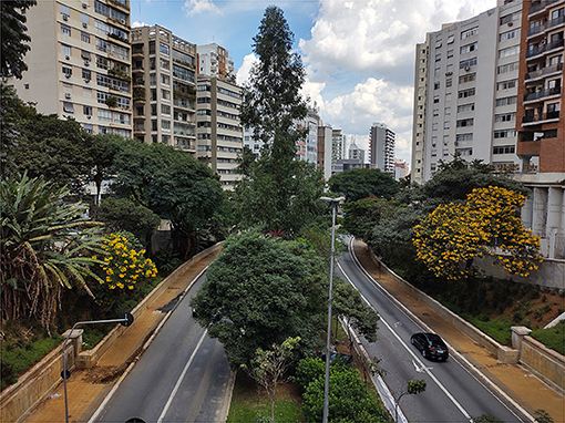
Figure 2. Bibi stream channeled into closed galleries at July 9th Avenue (by the authors).
In the 1980s, with the growth of drainage problems and the incorporation of environmental debates into the production of urban space, the model underwent its first change, with the guideline of no longer building closed galleries, but making open channels (Figure 3). Here, although the sociotechnical regime has adjusted to the speeches and even incorporated new actors, it has not changed. The presence of large resources and the creation of specific lines of financing for drainage (Jorge, 1987) accelerate the implementation of interventions, but, at that moment, alongside the permanence of the avenues in the floodplains, there was no longer a relationship between them and the structural road plans. Therefore, wherever there was a stream, it was considered an opportunity to build an avenue (Travassos, 2004). In the 1970s and 1980s, much of the streams in the oldest urbanization area were channeled (São Paulo (Municipality), Geprocav, (n.d.); São Paulo (Municipality), EMURB, COGEP, COPLASA, 1974; São Paulo (Municipality), Sempla, 1982), in both forms, open and closed. In this sense, although the sociotechnical landscape was changing, especially at the international level, it was still not enough to cause changes in the sociotechnical regime. However, it started to create conditions for the emergence of some sociotechnical niches, as will be further presented in this paper in more detail.
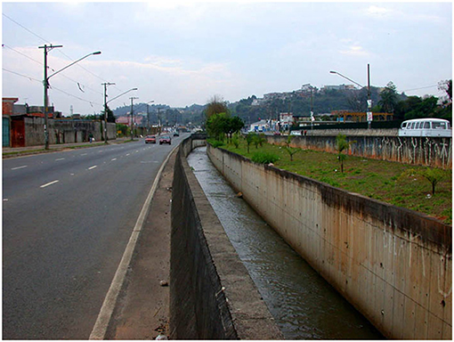
Figure 3. Inhumas stream at Arraias do Araguaia Avenue (by the authors).
Thus, the open channeling with the construction of valley-bottom avenues remained as a hegemonic discourse and practice until the beginning of this century. Then, the Executive Group of the Program of Canalization of Streams, Implementation of Roads, and Environmental and Social Recovery of Valley-bottoms (GEPROCAV) was quietly dismantled. This particular sector of the Secretariat of Urban Infrastructure was responsible for maintaining the sociotechnical regime in the Municipality since the 1980s.
At that moment, because of the changes brought about by the Strategic Master Plan of 2002 (Municipal Law No. 13,430), which instituted the Environmental Recovery Program for Water Courses and Valley-bottoms, the debate on the construction of linear parks began to gain traction. In conjunction with the Regional Master Plan of 2004, 146 linear parks bordering the water network were proposed (Silva-Sánchez and Jacobi, 2012; São Paulo (Municipality), 2020). The strengthening of the Secretariat of the Environment (SVMA) in the mid-2000s was also fundamental for the discourse on the recovery of rivers and streams to gain political space. In 2006, a working group was created under its management to operationalize the implementation of linear parks (Ordinance SVMA 75/2006). Around 25 linear parks were implemented, with most of them occurring between the end of the 2000s and the beginning of the 2010s. Notably, the number of parks is slightly higher as there are parks that are not managed by the SVMA (Figure 4) (Travassos, 2010; Silva-Sánchez and Jacobi, 2012).
Figure 4. Linear park at Itaim stream (by the authors).
Despite the promising data, it is necessary to point out two issues. The first one is that most of the urban rivers that have received public interventions since the beginning of the 20th century are in the first two spatial configurations. That is, where there was a public policy, the main result was the one recommended by the sociotechnical regime in force. After it arrived in mid-2010, the implementation of new linear parks, which can be characterized as a sociotechnical niche, dropped dramatically.
Furthermore, it should be noted that the fourth spatial configuration—rivers that cross precarious settlements (slums or favelas)—is the most serious in the São Paulo Municipality. This configuration is abundantly present in the peripheries, in spaces that have never been the subject of public urbanization policies. Thus, there are hundreds of kilometers of urban rivers that have not received any type of treatment of their beds or banks which then has created serious risks for the population that lives there (Figure 5).
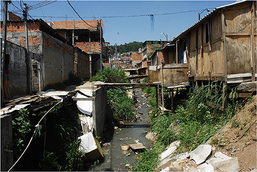
Figure 5. Precarious settlement at Corumbé stream (by the authors).
The presence of rivers in precarious settlements on the peripheries already indicates that these historical regimes of intervention have specific spatialities. Specific spatialities, in the context of inequality in Brazilian cities, also mean that different social classes have, in their neighborhoods, different configurations and degrees of infrastructure—which includes the treatment of rivers and streams. In the São Paulo Municipality, the gallery system under the roads is mostly in the middle- and upper-class neighborhoods (Figure 6).
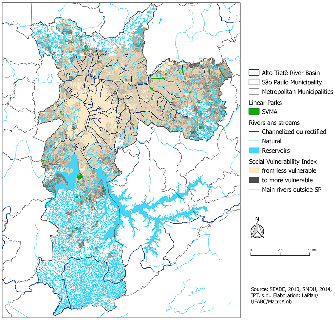
Figure 6. Urban rivers and vulnerability at São Paulo municipality.
The transition in discourses should also not lead to the false idea that open and closed channeling associated with new or existing road systems are not being carried out in the Municipality. The data collected for this article show that the amount of these interventions is much higher than the implementation of linear parks and continues to be the model for urbanization. On the other hand, in the most central areas, there is a growing clamor for the ecological restoration of rivers and streams. There is also a construction of a false discourse that establishes that the totality of the city's watercourses is buried or that these are the main issues presently related to the urban rivers, thus giving rise to the prioritization of plans and projects of “renaturalization” (Brocaneli and Stuermer, 2008; Viana, 2014; Algodoal, 2019; Conselho Municipal do Meio Ambiente e Desenvolvimento Sustentável – CADES, 2019; Ribeiro, 2020), which happen to be concentrated in the central areas of the city.
“In the Making” Transition
To show two points, we can discuss some quantitative aspects and the three levels of the MLP that are a consequence of the programs and projects of each river spatial configuration in São Paulo. The first one is that the sociotechnical transition is “in the making” and currently the sociotechnical regime of the last century seems to have resumed the hegemony in the definition of actions. At the same time, external forces and pressures—especially from the environmental global platforms—have been increasing the conditions for establishing new policies and initiatives, such as the 1992 Rio Declaration and Agenda 21. Despite the neoliberal policies of the period with budget restrictions and privatizations, the Federal Constitution of 1988 and the regulatory frameworks that would come next regarding planning and the environment have established an outline of principles and instruments. These items have created suitable conditions so that agents from niches (micro-level), organizations, the academy, and the government could propose innovations to processes and projects. Then, at the end of the 2000s, there were conditions for a just transition, but its trajectory had not been linear, as one can see in the upcoming table (Table 1). It summarizes plans, programs, and projects and characterizes a transition process that is not completed yet. The non-completeness is configured in summary by the notable presence of new proposals that have been poorly implemented or even not implemented at all. There is a relation between the typology of interventions (in bold, third column), for example, canalization vs. comprehensive and the level of implementation.
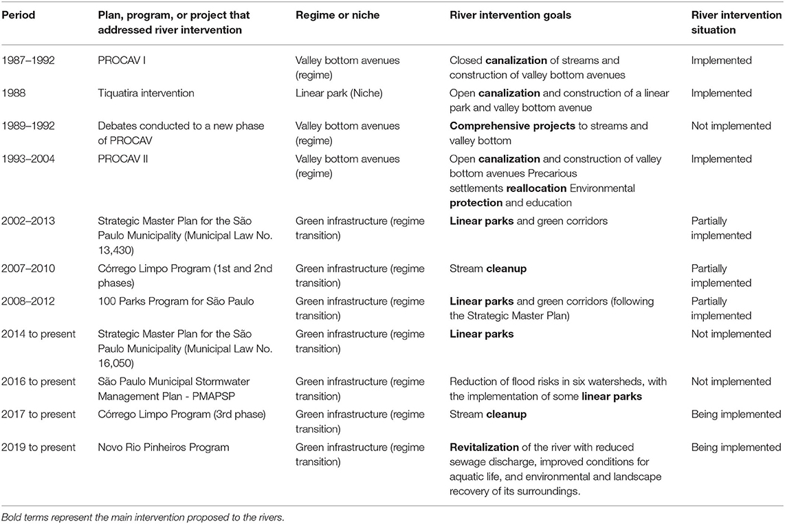
Table 1. Main intervention proposals to urban rivers and associated sociotechnological regime or niche experience.
Also, the contours of the current transition discourse fail to recognize the main challenge of environmental and spatial conditions and justice, which is the prioritization of innovations in the peripheries. So, while the agenda for a new relationship between rivers and the city has won, it has failed to challenge the status quo of urban inequality, water degradation, and the jeopardizing of ecosystem services.
At the beginning of the 21st century, under the implementation of the second stage of the Program for Canalization of Streams and Environmental and Social Recovery of Valley-bottoms (Procav II), which had begun in 1993, the standard intervention had been the majority. Its previous stage, Procav I, 1987, echoed the paradigm established throughout that century, the channeling of streams, and the construction of avenues on its banks, and was managed by the then Secretariat of Public Roads through its executive group, GEPROCAV. At that time, the program was financed by the Inter-American Development Bank, IDB, which replaced the federal drainage financing lines that existed during the dictatorial period (Travassos, 2004). Nevertheless, between the projects in Procav I, there was the formation of a sociotechnical niche, and a unique and isolated experience undertaken until that moment, which was the construction of a linear park along the Tiquatira River in 1988. The project had been exclusively designed by technicians from municipal and state bodies, without centrality in the sociotechnical regime, who can be considered as fringe actors (São Paulo (State), SOMA, Cetesb, DAEE, 1984).
Between 1989 and 1992, with the implementation of Procav I in progress, a new phase for the program began to be discussed under the progressive management of Mayor Luiza Erundina from the Workers Party. Subsequently, the name of the program was changed to “Program for the Environmental and Social Recovery of Valley Bottoms in the São Paulo Municipality.” There was the idea of elaborating comprehensive projects in which the treatment of valley bottoms did not initially presuppose the construction of roads on the stream banks. Accordingly, this would allow the treatment of a larger number of watersheds with the same investment of resources (São Paulo (Municipality), Câmara Municipal, Comissão Especial de Estudos Sobre Enchentes, 1995). In addition, it could lead to the diversification of spatial results. However, in 1993, the engineer, Paulo Maluf, a right-wing politician with strong relationships with urban infrastructure entrepreneurs, was elected as mayor, and the road system was once again prioritized.
Yet, the dominant sociotechnical regime of valley-bottom avenues has not changed. At that time, Procav II presented two important inflections regarding the first stage of the program, which can be characterized as a predevelopment phase of a sociotechnical transition. The first of these inflections was institutional, with the insertion of the Secretariats of Housing (SEHAB) and of the Environment (SVMA) in GEPROCAV, which led to an expansion of the actors beyond the engineers in the design of the program. Thus, two other programs were created parallel to the channeling and construction of roads: social housing and environmental protection and education. This reflected a change in the technological landscape both globally and locally. The growth presented in the discourse about urban sustainability and the recognition of the exponential increase in the population living in precarious settlements motivated the broadening in the scope of the program. The regulatory frameworks and national systems on water, sanitation, environment, and urbanization, based on the Federal Constitution of 1988, kept deepening the possibilities for macro-level innovations.
Regarding precarious settlements, despite the difficulty of specifying their data, studies at the time observed that in 1973 about 1% of the population were living in these conditions (Saraiva and Marques, 2007). In 1987, the number jumped to 7.7% of the population, 813,000 people, with almost 50% living on the banks of streams (Rolnik et al., 1990; Taschner and Pequeno, 1992). New calculations showed that, in 1991, the number doubled again and about 15% of the population of the municipality was living in favelas (Marques et al., 2003). The population resettlement program designed in Procav II, however, had brought back old and questionable solutions. The population that lived in the intervention areas, i.e., where the avenues would be built, would be removed to three social housing facilities in the limits of the urban area, as the 14 streams to be channeled could be found halfway between the central areas and the extreme periphery.
The environmental programs, in turn, had been demanded as a counterpart to the IDB in the new round of loans for the program (São Paulo (Municipality), Secretaria De Vias Públicas, 1994). Hence, two sub-projects were created: “Environmental Protection of Watersheds” and “Environmental education.” The first one specifically referred to the creation and maintenance of green areas in the watersheds that were the objects of the interventions. The second created an environmental education program for the residents of the watersheds and the housing complexes to be built (São Paulo (Municipality), Secretaria Do Verde E Do Meio Ambiente (SVMA), PROCAM (PROCAV II AMBIENTAL), 1995).
The second inflection of Procav II was technical. After a century of interventions aimed at increasing the speed of flow of the river channels, without ever being able to resolve the issue of floods always being transferred downstream, the State Government, through the Department of Water and Electricity (DAEE), approved the Macro Drainage Plan of the Alto Tietê Basin1 in 1999 (São Paulo (State), DAEE, ENGER-PROMON-CKC Consortium, 1999). This plan introduced the following important change in the logic of urban drainage: the restriction flow. Specifically, restriction flow is the highest flow supported by the main rivers in the basin and serves as the maximum flow parameter for intervention in the tributaries.
This measure leads to the need for reserving water in the watersheds of these tributaries. However, among various possibilities for reserving, a new practice that soon became hegemonic started to be implemented: the construction of large containment reservoirs, known in Brazil as big pools (piscinões). This innovation places the works in progress by Procav II in a paradox formed by channels designed to quickly expel the waters and the construction of reservoirs to stop them (Travassos, 2004).
In 2003, after several interruptions and reprogramming, there were still seven Procav II streams under construction, three reservoirs were being built, and some of the residents were still in precarious settlements in the watersheds. The Environmental Education Program, although well-evaluated by residents who would not be removed (Sacardo, 2001), had stopped 6 years earlier.
At the beginning of the century, in 2002, the Strategic Master Plan for the São Paulo Municipality, PDE (Municipal Law No. 13,430), was approved. Furthermore, it was complemented by the Regional Strategic Plans (PREs) (Municipal Law No. 16,050), which were elaborated for each municipal subprefecture in 2004.2 The plans were based on the Statute of the City, a federal law that oriented the review of the Master Plan in Brazil at the macro-level. The approval of these municipal plans, under new progressive management, also of the Workers' Party (PT), now with Marta Suplicy as mayor, brought light again to the several critical issues about the established way of urbanization of the valley bottoms and a possibility of change in the relationship between the rivers and the city. The water network was considered as one of the four municipality structural elements. So, the main planning guideline for this network and its floodplain treatment was the creation of a series of linear parks and green corridors. Thus, the plan represented a significant change in the discourse on the treatment to be given to rivers and streams in São Paulo, pointing to new forms of design and intervention in these areas.
In the context of the sociotechnical landscape, both in the debates of the early 1990s and in those carried out for the preparation of the PDE 2002, we assume that the main role of pressure for the transition mainly came from a group of municipal technicians—at this moment mainly the SVMA technicians—and various elements from academia. During this period, there were no environmental movements organized around the agenda of public policies for the urbanization of rivers and their banks yet. Despite this, there was social pressure in favor of the depollution of the Tietê River, with some significant victories in the 1990s (SOS Mata Atlântica, 2016). Conversely, the macro-level went on creating suitable conditions for innovations in local policies and processes.
Only 4 years after the approval of the PDE 2002, under the neoliberal government of Gilberto Kassab—who had been Secretary of Planning in the administration that replaced Maluf, being very close to his group, but who gave political importance to the SVMA—the municipality began to organize itself to set in motion its new guidelines for urban rivers. The already mentioned workgroup was created but was formed exclusively by SVMA technicians. Without the participation of other public bodies, therefore, it was quite limited. Travassos (2010) and Silva-Sánchez and Jacobi (2012) showed how the implementation of linear parks needed to face a complex territorial and institutional situation, which required the articulation of several actors, be sufficient to think in an integrated program, the different intervention's dimensions, and the specificities of each stream and hydrographic basin. It would be necessary to integrate housing, sanitation, green areas, urban drainage, and mobility so that the urbanization projects of the rivers and their banks should result not only from a sociotechnical, but also from a just transition. Thus, having its installation in the bulge of a single organ, weakened its potential for change.
In 2008, the linear parks became part of the 100 Parks Program for São Paulo, which aimed to create a bank of public lands that were suitable for the provision of environmental services. The program also intended to create a plan to adapt to global climate changes (Devecchi, 2008), thereby echoing the global agenda. Then, it did happen, as most of the implemented linear parks avoided the most precarious and conflicting areas. This was because there was no integrated planning strategy or funding which allowed the recovery of abandoned or occupied public lands with functions that could be easily relocated. Also, the project and implementation were made expeditiously and without any social or popular participation. Contrastingly, the parks were mainly implemented in peripheral areas and represented a gain—even if partial—in infrastructure in these regions (Travassos, 2010).
However, in just over 5 years, the pace of proposals and projects dropped considerably, and the next government, again from the Workers' Party with Fernando Haddad, did not emphasize the program. In 2015, the last linear park in São Paulo was inaugurated, still reminiscent of the moment before it, as may be seen in the portal of the Secretary of the Environment, SVMA. The Strategic Master Plan approved in 2014 (Municipal Law No. 16,050), which is still in force, followed the guidelines brought by its predecessor, but the proposed linear parks have not been implemented yet.
Currently, the data collected on digital media3 indicate that there are only two linear parks in more advanced stages of debate within the municipal government; specifically, both are in the northern zone. This same data reveals that there is a strong resumption of channeling streams and construction of road systems on the river banks with varying degrees of importance in the constitution of the municipal road system. In the news database of the Secretariat of Urban Infrastructure, there are 29 projects or works completed or in progress, with rare exceptions, were found in streams located on the outskirts of the city. In addition, although the 2014 Strategic Master Plan had included a specific section on the recovery of valley bottoms, with the objective of articulating sanitation, drainage, implementation of linear parks, and urbanization of slums, there was no more municipal effort to prioritize planning and design in these areas.
Relegated Justice
At the beginning of 2021, the Secretariat for Infrastructure and Works (the renamed SIURB) made available the “Drainage Notebooks” prepared for six hydrographic watersheds in the municipality, in 2016 (São Paulo (Municipality), Secretaria Municipal De Infraestrutura Urbana E Obras (SIURB), Fundação Centro Tecnológico De Hidráulica (FCTH), 2016a,b,c,d,e,f). In the second semester, they published six other notebooks, elaborated in 2019 (São Paulo (Municipality), Secretaria Municipal De Infraestrutura Urbana E Obras (SIURB), Fundação Centro Tecnológico De Hidráulica (FCTH), 2019a,b,c,d,e,f). These proposals are presumably associated with the São Paulo Municipal Stormwater Management Plan (PMAPSP), a plan that is not a plan, but the sum of these watersheds programs, without any consideration about why these and not other choices. From 2016 to 2019, it is possible to notice a large increase in proposals linked to green infrastructure and also river daylighting. This increase shows how, from the infrastructure point of view, there is a transition under consolidation. On the other hand, the interventions are still thought of in a sectorial way. Although sanitation and roads are mentioned, the precarious settlements practically disappear, especially in the 2019 proposals, even in the peripheral basins, where their presence is significant.
Half of the 12 watersheds are in consolidated areas, occupied by middle- and upper-middle class population; two of them are more diverse in terms of income, and four of them are occupied predominantly by low- and middle-income population. In the last six basins, the closer to the headwaters, the greater the prevalence of low-income population and the presence of precarious settlements. The proposed interventions, however, do not prioritize areas with less infrastructure, nor do they allocate more resources to where there is more precariousness, which can be seen in two comparisons. In 2016 notebooks, although the linear parks proposals were quite conservative, it was already possible to notice its unequal distribution, while for the peripheral Morro do S basin, with its 22 km2 area, a single park with 4 thousand m2 was proposed; for the Águas Espraiadas Creek basin, with its 11 km2, in an area of intense land valuation, a linear park with 111 thousand m2 was proposed. In 2019, the difference in resources provided for the consolidated watersheds compared to the peripheral ones is striking. Considering the proposals that advocate more elements of green infrastructure, the resources foreseen for the Uberaba watershed, which runs through upper and upper middle class neighborhoods, are 98 million reais per km2, while for the Aricanduva River watershed, which is on the periphery and shelters a relevant part of the precarious settlements and risk areas, the foreseen values are 8 thousand reais per km2.
Simultaneously, the number of precarious settlements located on the banks of streams remains very high and growing. Although it is not possible to update the number of residents since the last Brazilian Demographic Census dates from 2010, the mapping carried out on data from the Municipal Housing Secretariat in 2015 indicates that there were about 247,000 households in precarious settlements on the banks of bodies of water (Travassos et al., 2017). In other words, there is still an intrinsic relationship between urban rivers and favelas in the city.
Conversely, it is also in the last decade that the perception about “unseen rivers,” “invisible rivers,” or “hidden rivers” in the urban areas has gained strength; correspondingly, this is accompanied by the exponential growth of academic works and media articles on the subject. A search on the Scholar Google portal for these terms in Portuguese resulted in significant differences between the decades of 2000 and 2010. Accordingly, for “unseen rivers,” the total ranged from 11 to 18; for “invisible rivers,” from 6 to 118; and for “hidden rivers,” from 11 to 25. Considering the most prevalent term, together with the term “periphery” in the complete period, there are only 33 results, with the term “favelas” accounting for only 20. In a media search for the same term utilizing Google Search Advanced Engine, there is no report before 2010. Then, from that point, there are 140 reports, with only 40 of them noting the term “periphery,” which is mostly related to a play with that name staged in a neighborhood in the far eastern section of the city. The term “favela” appears in only 20 news stories. Through this research, it was possible to note the strength that the discourse about urban rivers in São Paulo has gained. Urban rivers were the subject of theater groups, environmental movements, collaborative mapping initiatives, workshops to recognize watercourses, and pages on social networks. However, an important part of these speeches is incomplete once it is predominantly based on the criticism of the first spatial configuration that we dealt with, whose spatial location is in the neighborhoods of the middle and upper classes.
An example of the form that this discourse takes can be seen in a short documentary entitled “Between concrete walls,”4 which was produced by FAPESP, the magazine of the main research foundation in the country. The images and speeches selected for the documentary make it clear that rivers under the consolidated city are spoken of when the intention is to integrate rivers into the urban landscape. Furthermore, there is not a single image of precarious settlements. So, reintegration, renaturalization, and coexistence with water bodies are terms mobilized in a kind of metonymy, which takes a specific spatial configuration as universal, without complexifying the look at the various spatial configurations of urban rivers in the city. Moreover, although there are small initiatives that are echoed from periphery to periphery in some neighborhoods, as shown by Moreno and Momm (2019), the discourses linked to the central areas have a much greater power to transform themselves into public policy.
In particular, two recent programs illustrate how new public policy proposals, currently underway in the municipality, deepen infrastructure inequality and the unequal approach to urban rivers and streams. They are the third phase of the Córrego Limpo Program and the Novo Rio Pinheiros Project.
The Córrego Limpo Program was created in 2007 by the São Paulo State Sanitation Company, Sabesp, in conjunction with city hall (São Paulo (State), SABESP, São Paulo (Municipality), 2007). The objective was to clean up 300 rivers and streams through integrated sanitation, slum upgrading, and the creation of linear parks. The first phase of the program had two criteria for prioritization, which were: open channeled streams and basins in which the works could be completed in up to 2 years. Given the current situation, it is not difficult to imagine that such criteria would be very difficult to be achieved, except in watersheds whose infrastructure was almost complete. Thus, it was precisely in the areas of better infrastructure that the program concentrated its efforts, centering on complementing the structures of sanitary sewage. Since 2017, its third phase has been underway, presenting, according to its managers, two “innovations,” the first of which is the establishment, until 2039, of long-term goals. The second one involves the focus on streams channeled in closed galleries, “located in densely urbanized and important tributaries of the two most important hydrographic basins in the capital.” (São Paulo (Municipality), Secretaria Do Verde E Do Meio Ambiente (SVMA), 2017). These “closed streams,” after being cleaned up, “can be returned to the urban landscape through renaturalization projects” (São Paulo (Municipality), 2020). The report also highlights the positive impact of the measures in upper-class regions, such as Moema and Ibirapuera. There were interventions proposed for 11 streams in the period between 2019 and 2020, only two of which were peripheral (São Paulo (Municipality), Comitê Gestor Dos Serviços De Água E Esgoto Da Capital Paulista, 2019).
The Novo Rio Pinheiros Project, at the main tributary of Tietê River (Figure 7), is even clearer in reproducing inequalities, since it assumes the rupture between sanitation and housing works and treats consolidated and precarious areas differently. Launched in 2019, the program aims to reduce the sewage released in the tributaries of the river and to improve water quality, and fully integrate it into the city (Silva and Porto, 2020; São Paulo (State), SABES, 2021). This will be accomplished through the five following pillars: water treatment of tributaries, control of silting, solid waste collection and disposal, revitalization of banks, and environmental communication and education. In addition, these three business groups were planned: energy, water resources, and real estate (Momm et al., 2020).
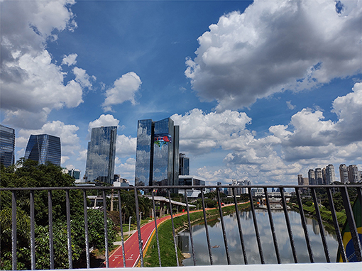
Figure 7. Pinheiros River landscape.
Attempts to clean up the Pinheiros River are not new, nor were the few financial resources invested in the project. It is the river flanked by the wealthiest neighborhoods and the most thriving business centers; it has experienced an intense wave of real estate appreciation in recent years, strongly related to the reconfiguration of the infrastructure, both real and planned (Tone, 2010; Ferrara, 2018). However, there are also watersheds of its tributaries that are occupied by precarious settlements, whose urban and sanitation solutions are complex. Thus, to achieve the goal of a clean river and the construction of the desired waterfront in the wealthy neighborhoods, the state government treats the urban areas of the basin in two ways. First, there is the complete infrastructure for the tributary watersheds in the regular neighborhoods. Second, there is the treatment of the river mouth of the tributary rivers whose watersheds are occupied by precarious settlements. In other words, the State assumes the maintenance of very serious social and environmental liabilities as long as the sanitary effluents from these spaces do not contaminate the areas that matter for business investors and upper-classes. In several aspects, the set of these plans represents the reproduction and intensification of inequalities—that is, it shows that there is no just transition, or that justice is not an objective to pursue.
Final Considerations
The trajectory described above shows that the policies and projects concerning the relationship between rivers and urban spaces—specifically through linear parks and other leisure open spaces—have not been able, up to the moment, to be configured as a new sociotechnical regime. This incompleteness is due to both the point of view of the relationship between the actors and institutions, and from the point of view of the spatial and environmental results of these policies and projects. The resumption of interventions in channeling streams accompanied by a road system shows that there is resistance and inertia of the regime in force throughout the 20th century. We highlight, however, the changes that have occurred since 1980, with the growth of the urban environmental agenda. It was responsible, at first, for some modification in infrastructure proposals, from closed to open channeling, and after the expansion of the aspects that should be addressed by urbanization programs, especially issues related to precarious settlements and environmental education. At the end of the 2000s, the construction of new intervention proposals seemed to advance through all these themes, although in a sectorial and incomplete way, with many integration problems that needed to be solved to enable a real environmental and social recovery of the urbanized valley bottoms. However, from the middle of the last decade, with the growing demand for green infrastructure and the recovery of waterways, the programs that until then were designed for rivers that had never been subject to intervention, began to focus on restructuring the relationship between rivers and cities in consolidated and higher income areas. It is noteworthy that these processes of advances and setbacks are part of the sociotechnical transition. In this sense, it is possible to affirm that there is a sociotechnical transition “in the making,” especially because sociotechnical niche experiences remain, and so do external pressures and resistances in the macro-level boosting these initiatives.
Regarding the interventions carried out by the public authorities, it is possible to state that, in the São Paulo Municipality, the sociotechnical niches are formed by fringe actors, with little political strength, however institutionalized. At the center of this group is the SVMA, with a portion of its technicians, and some presence of technicians from other government agencies. That was the case of the intervention of the Rio Tiquatira and even in the institutional changes verified in GEPROCAV between the first two phases of Procav. It is necessary to recognize that these actors pressured, at various times, the current sociotechnical regime, having been able for a little less than a decade to change the role of public authorities in interventions in urban rivers.
The hegemonic regime's alteration is supported by the continuous perception that previous works did not result in the reduction of the impacts of pollution and floods associated with the city's rivers. These three aspects put pressure in this alteration: (1) climate change and extreme events, which pressure local governments to respond to the increase of deaths and more intense and frequent material losses; (2) the various initiatives for urban rivers around the world, which yielded political fruits to the managers in charge of them and created spaces for real estate valuation; and (3) policies and global platforms, such as the one on climate change, that include not only specific groups related to climate and the environment but the national coalition and financial groups which were oriented by these agendas. In contrast, neoliberalism as a global trend has been increasing inequalities as it reduces the role of the government. This force results in the dismantling of social policies that make up for the low-income population of poorer countries and their ability to provide resources and basic infrastructure. Still, on the topic of neoliberalism and infrastructure, the privatization of urban infrastructure and essential services tend to make equitable and universal solutions more scarce. In this sense, if the presence of precarious settlements on the river banks was in the speeches and political agendas associated with urban rivers until a decade ago, it has now disappeared in the current policies. The Novo Rio Pinheiros Project is the most explicit in this sense, for deliberately treating the watersheds of regular occupation and those of informal occupation in an unequal way and permanently separating sanitation works from urbanization ones where there is no real estate interest. This can be deeply configured as an act of omission.
Considering the debate of just transition, it is possible to identify issues related to participation, time, space, and the type of proposals that refer to the reproduction of inequalities. Considering this literature and the cases, participation was absent by the low-income population throughout all the programs and projects that were elaborated and implemented. There was also an inadequacy of the project and construction deadlines in relation to the complexity of the river and buildings situations. In the case of São Paulo, a great example can be seen in the Córrego Limpo Program, which, when selecting more complex watersheds for operation, limited the period to 2 years. This action made it unworkable and now it has a long-term schedule, also aiming at the possibility of “renaturalizing rivers” in the most consolidated and wealthy areas of the city.
In addition, the discourse of valuing the relationship between nature and city related to urban rivers also poorly includes the issues of the periphery and precarious settlements, as it is possible to learn from the academic works and media news presented. While discussing the need to look at rivers in consolidated areas and advancing in studies and proposals of typologies and ways of treating these rivers, the city continues to channel rivers in the peripheries. This approach creates a context of two different cities, with two different sociotechnical landscapes regimes. The status quo of inequality remains in peripheral and precarious areas.
In this context, it is necessary to move forward in the development of the approach on the sociotechnical transition and its relation to justice. This approach is necessary for the understanding of the advances, setbacks, and inertia of new sociotechnical regime or the implementation of a new paradigm in the relationship between infrastructure and existing urban rivers. Furthermore, the sociotechnical transition literature has advanced in terms of its direction toward sustainability. However, for the context of large cities in peripheral countries, it is necessary to strengthen the link between this literature and that of justice, since an important part of the advances and setbacks are strongly related to the territorial inequalities of these cities. In other words, advances and setbacks are often concomitant in time and separated in space, which makes the analysis of the transition more complex. Above all, it is essential to build a coalition in favor of a just transition, which reverses the logic of the distribution of resources and innovation and prioritizes peripheral spaces through public housing, sanitation, drainage, park developments, and mobility policies.
Data Availability Statement
The original contributions presented in the study are included in the article/supplementary materials, further inquiries can be directed to the corresponding author.
Author Contributions
LT contributed to the literature review and carried out the documentary and empirical research presented in the article. SM contributed to the literature review and documentary research. All authors contributed to the article and approved the submitted version.
Funding
The São Paulo Research Foundation supported this study (FAPESP), with its Thematic Project MacroAmb, Environmental Governance in São Paulo Macro Metropolis in a climate variability context (2015/03804-9) and the Scholarship abroad, including the research, Planning in conditions of rapid socio-environmental change: a theoretical-methodological framework for comparative analysis (2018/12245-1).
Conflict of Interest
The authors declare that the research was conducted in the absence of any commercial or financial relationships that could be construed as a potential conflict of interest.
Publisher's Note
All claims expressed in this article are solely those of the authors and do not necessarily represent those of their affiliated organizations, or those of the publisher, the editors and the reviewers. Any product that may be evaluated in this article, or claim that may be made by its manufacturer, is not guaranteed or endorsed by the publisher.
Footnotes
1. ^The Alto Tietê Basin covers 35 of the 39 municipalities in the São Paulo Metropolitan Region.
2. ^The municipality of São Paulo is divided into 31 Subprefectures (Municipal Decree n° 13,399/2002).
3. ^The data was collected in the “News Page” of the Secretariat of Urban Infrastructure, SIURB, between 2010 to the present. Available online at: https://www.prefeitura.sp.gov.br/cidade/secretarias/obras/noticias/ (accessed March 2021).
4. ^Original title: “Entre paredes de concreto”. Available online at: https://www.youtube.com/watch?v=l9GF0qpOhOY&list=UUYhTgGdeaBbbZ-h_LVJ_6bw (accessed March, 2021).
References
A Construção São Paulo (1972). Avenidas de fundo de vale valorizam a paisagem. A Construção São Paulo, n°1266. São Paulo: PINI.
Anguelovski, I., Shi, L., Chu, E., Gallagher, D., Goh, K., Lamb, Z., et al. (2016). Equity impacts of urban land use planning for climate adaptation: critical perspectives from the global north and south. J. Plan. Educ. Res. 36, 333–348. doi: 10.1177/0739456X16645166
Brocaneli, P. F., and Stuermer, M. M. (2008). Renaturalização de rios e córregos no município de São Paulo. Exacta 6, 147–156. doi: 10.5585/exacta.v6i1.799
Canil, K., Lampis, A., and Santos, K. L. (2020). Vulnerabilidade e a construção social do risco: uma contribuição para o planejamento na macrometrópole paulista. Cad. Metrop. 22, 397–416. doi: 10.1590/2236-9996.2020-4803
Conselho Municipal do Meio Ambiente e Desenvolvimento Sustentável – CADES (2019). Ata da 207 ª Reunião Plenária Ordinária. Diário Oficial da Cidade de São Paulo, terça-feira, 26 de março de 2019.
Devecchi, A (2008). Programa 100 parques para São Paulo. 12a Audiência de Sustentabilidade da Sabesp. São Paulo.
Estado de São Paulo (1984). Progresso Paulista. Jornal O Estado de São Paulo, 3 de julho de 1894. São Paulo.
Estado de São Paulo. (1962). Canalização de Córrego e Moema. Jornal O Estado de São Paulo, 12 de? julho de 1962. São Paulo.
Ferrara, L. N (2018). “O lugar da natureza na produção do espaço metropolitano: do metabolismo urbano industrial para o imobiliário financeiro,” in: Paulo Cesar Xavier Pereira. (Org.). Imediato, global e total na produção do espaço: a financeirização da cidade de São Paulo no século XXI. 1ed.São Paulo: FAUUSP, Vol. 1, 137–160.
Fitzgibbons, J., and Mitchell, C. (2019). aJust urban futures? Exploring equity in “100 Resilient Cities”, World Dev. 122, 648–659. doi: 10.1016/j.worlddev.2019.06.021
García Soler, N., Moss, T., and Papasozomenou, O. (2018). Rain and the city: pathways to mainstreaming rainwater harvesting in Berlin. Geoforum 89, 96–106. doi: 10.1016/j.geoforum.2018.01.010
Gaventa, J., and Martorano, B. (2016). Inequality, power and participation – revisiting the links. IDS Bulletin 47:5. doi: 10.19088/1968-2016.164
Geels, F. W (2019). Socio-technical transitions to sustainability: a review of criticisms and elaborations of the Multi-Level Perspective. Curr. Opin. Environ. 39, 187–201. doi: 10.1016/j.cosust.2019.06.009
Geels, F. W., and Schot, J. (2007). Typology of sociotechnical transition pathways. Res. Policy 36, 399–417. doi: 10.1016/j.respol.2007.01.003
Heffron, R., and McCauley, D. (2018). What is the ‘just transition'? Geoforum 88, 74–77. doi: 10.1016/j.geoforum.2017.11.016
Hodson, M., and Marvin, S. (2010). Can cities shape socio-technical transitions and how would we know if they were? Res. Policy 39, 477–485. doi: 10.1016/j.respol.2010.01.020
Instituto Brasileiro de Geografia e Estatística. (2021). IBGE Cidades. Available online at: https://cidades.ibge.gov.br/ (accessed March 15, 2021).
Jorge, W. E (1987). “A política nacional de saneamento, pós 64”. Tese de doutorado apresentada a FAUUSP. São Paulo: FAUUSP.
Maia, F. P., and Cintra, J. F. Û. (1924). Um problema actual: Os grandes melhoramentos de São Paulo. n. 26-31. São Paulo: Boletim do Instituto de Engenharia.
Markard, J., Geels, F. W., and Raven, R. (2020). Challenges in the acceleration of sustainability transitions. Environ. Res. Lett. 15:8. doi: 10.1088/1748-9326/ab9468
Marques, E., Torres, H., and Saraiva, C. (2003). “Favelas no município de São Paulo. Estimativas de população para os anos de 1991, 1996 e 2000,” in Associação Nacional de Pesquisa e Pós-Graduação Em Planejamento Urbano E Regional (Anpur). Anais do X Encontro Nacional da ANPUR. Belo Horizontep.
Meerow, S., and Newell, J. P. (2016). Urban resilience for whom, what, when, where, and why? Urban Geogr. 40, 309–329. doi: 10.1080/02723638.2016.1206395
Momm, S., Kinjo, V., and Frey, K. (2020). Tramas do planejamento e governança na transformação de rios em metrópoles globais: uma reflexão sobre casos internacionais e em curso na Macrometrópole Paulista (Brasil). Cad. Metrop. 22, 499–525. doi: 10.1590/2236-9996.2020-4808
Moreno, R., and Momm, S. (2019). O Conceito de Infraestrutura E A Gestão de Águas Pluviais. A aplicação do conceito de vazão de base em projetos da Região Metropolitana de São Paulo (Brasil). Anais XVIII ENANPUR. Available online at: http://anpur.org.br/xviiienanpur/anais (accessed March 20, 2021).
Newell, P., and Mulvaney, D. (2013). The political economy of the ‘just transition'. Geogr. J. 179, 132–140. doi: 10.1111/geoj.12008
Porchat, M. L (1920). Do que precisa São Paulo. Um punhado de ideias sobre a cidade. São Paulo: Duprat.
Ribeiro, W (2020). Renaturalização de rios é uma das saídas para evitar enchentes em São Paulo. Interview to REDE TVT, 11 de fevereiro de 2020. Available online at: https://www.youtube.com/watch?v=KmG1dpVKBlI (accessed July 30, 2021).
Rolnik, R., Kowarick, L., and Somekh, N. (1990). São Paulo: crise e mudança. São Paulo: Brasiliense.
Routledge, P., Cumbers, A., and Derickson, K. A. (2018). States of just transition: Realising climate justice through and against the state. Geoforum 88, 78–86. doi: 10.1016/j.geoforum.2017.11.015
Sacardo, G. A (2001). Participação e subjetividade num programa de educação ambiental. São Paulo : Faculdade de Saúde Pública, University of São Paulo, 2001. Doctoral Thesis in Serviços de Saúde Pública. Available online at: doi: 10.11606/T.6.2020.tde-26032020-112254 (accessed March 18, 2021).
São Paulo (Municipality) Câmara Municipal, Comissão Especial de Estudos Sobre Enchentes. (1995). Relatório final. São Paulo: mimeo.
São Paulo (Municipality), Comitê Gestor Dos Serviços De Água E Esgoto Da Capital Paulista (2019). Plano Municipal de Saneamento Básico de São Paulo. São Paulo. Available online at: https://gestaourbana.prefeitura.sp.gov.br/wp-content/uploads/2019/05/PMSB_Caderno_Completo_-final-para-impressa%CC%83o.pdf (accessed July 31, 2021).
São Paulo (Municipality) EMURB, COGEP, COPLASA. (1974). Mapas e diagnóstico das bacias de drenagem da capital. 53 pastas, 11 volumes. São Paulo: Coplasa.
São Paulo (Municipality) Geprocav (n.d.). Programa de Canalização de Córregos, implantação do programa de canalização de córregos, implantação de vias e recuperação ambiental e social de fundos de vale – PROCAV II. Resumo ambiental. São Paulo: São Paulo, mimeo, undated
São Paulo (Municipality) Secretaria De Vias Públicas. (1994). Microdrenagem II. Plano final de reassentamento. São Paulo: SVP.
São Paulo (Municipality) Secretaria Do Verde E Do Meio Ambiente (SVMA), PROCAM (PROCAV II AMBIENTAL) (1995). Termo de referência do sub-projeto reforço institucional. São Paulo: SVMA.
São Paulo (Municipality) Secretaria Do Verde E Do Meio Ambiente (SVMA). (2017). Córrego Limpo entra na terceira fase. São Paulo, Available online at: https://www.prefeitura.sp.gov.br/cidade/secretarias/meio_ambiente/noticias/?p=235961. (accessed March 11, 2021).
São Paulo (Municipality) Secretaria Municipal De Infraestrutura Urbana E Obras (SIURB), Fundação Centro Tecnológico De Hidráulica (FCTH). (2016a). Caderno de Bacia Hidrográfica Córrego Água Espraiada. São Paulo. Available online at: https://www.prefeitura.sp.gov.br/cidade/secretarias/obras/obras_de_drenagem/index.php?p=230496 (accessed March 20, 2021).
São Paulo (Municipality) Secretaria Municipal De Infraestrutura Urbana E Obras (SIURB), Fundação Centro Tecnológico De Hidráulica (FCTH). (2016b). Caderno de Bacia Hidrográfica Córrego Cabuçu de Baixo. São Paulo. Available online at: https://www.prefeitura.sp.gov.br/cidade/secretarias/obras/obras_de_drenagem/index.php?p=230496 (accessed March 20, 2021).
São Paulo (Municipality) Secretaria Municipal De Infraestrutura Urbana E Obras (SIURB), Fundação Centro Tecnológico De Hidráulica (FCTH). (2016c). Caderno de Bacia Hidrográfica Córrego Jacu. São Paulo. Available online at: https://www.prefeitura.sp.gov.br/cidade/secretarias/obras/obras_de_drenagem/index.php?p=230496 (accessed March 20, 2021).
São Paulo (Municipality) Secretaria Municipal De Infraestrutura Urbana E Obras (SIURB), Fundação Centro Tecnológico De Hidráulica (FCTH). (2016d). Caderno de Bacia Hidrográfica Córrego Jaguaré. São Paulo. Available online at: https://www.prefeitura.sp.gov.br/cidade/secretarias/obras/obras_de_drenagem/index.php?p=230496 (accessed March 20, 2021).
São Paulo (Municipality) Secretaria Municipal De Infraestrutura Urbana E Obras (SIURB), Fundação Centro Tecnológico De Hidráulica (FCTH). (2016e). Caderno de Bacia Hidrográfica Córrego Mandaqui. São Paulo. Available online at: https://www.prefeitura.sp.gov.br/cidade/secretarias/obras/obras_de_drenagem/index.php?p=230496 (accessed March 20, 2021).
São Paulo (Municipality) Secretaria Municipal De Infraestrutura Urbana E Obras (SIURB), Fundação Centro Tecnológico De Hidráulica (FCTH). (2016f). Caderno de Bacia Hidrográfica Córrego Morro do S. São Paulo. Available online at: https://www.prefeitura.sp.gov.br/cidade/secretarias/obras/obras_de_drenagem/index.php?p=230496 (accessed March 20, 2021).
São Paulo (Municipality) Secretaria Municipal De Infraestrutura Urbana E Obras (SIURB), Fundação Centro Tecnológico De Hidráulica (FCTH). (2019a). Caderno de Bacia Hidrográfica Córregos Água Preta e Sumaré. São Paulo. Available online at: https://www.prefeitura.sp.gov.br/cidade/secretarias/obras/obras_de_drenagem/index.php?p=230496 (accessed March 20, 2021).
São Paulo (Municipality) Secretaria Municipal De Infraestrutura Urbana E Obras (SIURB), Fundação Centro Tecnológico De Hidráulica (FCTH). (2019b). Caderno de Bacia Hidrográfica Córrego Anhangabaú. São Paulo. Available online at: https://www.prefeitura.sp.gov.br/cidade/secretarias/obras/obras_de_drenagem/index.php?p=230496 (accessed March 20, 2021).
São Paulo (Municipality) Secretaria Municipal De Infraestrutura Urbana E Obras (SIURB), Fundação Centro Tecnológico De Hidráulica (FCTH). (2019c). Caderno de Bacia Hidrográfica Córrego Aricanduva. São Paulo. Available online at: https://www.prefeitura.sp.gov.br/cidade/secretarias/obras/obras_de_drenagem/index.php?p=230496 (accessed March 20, 2021).
São Paulo (Municipality) Secretaria Municipal De Infraestrutura Urbana E Obras (SIURB), Fundação Centro Tecnológico De Hidráulica (FCTH). (2019d). Caderno de Bacia Hidrográfica Córrego Pirajussara. São Paulo. Available online at: https://www.prefeitura.sp.gov.br/cidade/secretarias/obras/obras_de_drenagem/index.php?p=230496 (accessed March 20, 2021).
São Paulo (Municipality) Secretaria Municipal De Infraestrutura Urbana E Obras (SIURB), Fundação Centro Tecnológico De Hidráulica (FCTH). (2019e). Caderno de Bacia Hidrográfica Córrego Uberaba. São Paulo. Available online at: https://www.prefeitura.sp.gov.br/cidade/secretarias/obras/obras_de_drenagem/index.php?p=230496 (accessed March 20, 2021).
São Paulo (Municipality) Secretaria Municipal De Infraestrutura Urbana E Obras (SIURB), Fundação Centro Tecnológico De Hidráulica (FCTH). (2019f). Caderno de Bacia Hidrográfica Córrego Verde Pinheiros. São Paulo. Available online at: https://www.prefeitura.sp.gov.br/cidade/secretarias/obras/obras_de_drenagem/index.php?p=230496 (accessed March 20, 2021).
São Paulo (Municipality) Sempla. (1982). Diagnóstico de drenagem do Município de São Paulo. Versão Preliminar e Anexos. São Paulo: mimeo.
São Paulo (Municipality) Comissão de Pesquisa Urbana, SAGMACS. (1958). Estrutura urbana da aglomeração paulistana: estruturas atuais e estruturas racionais. São Paulo: Sagmacs.
São Paulo (Municipality). (2020). Secretaria do Verde e do Meio Ambiente (2020). Plano Municipal de Áreas Protegidas, Áreas Verdes e Espaços Livres (PLANPAVEL). São Paulo: mimeo.
São Paulo (State) DAEE, ENGER-PROMON-CKC Consortium. (1999). Plano Diretor de Macrodrenagem da Bacia Hidrográfica do Alto Tietê. Calha do Rio Tietê entre as Barragens da Penha e Edgar de Souza. Diagnóstico Hidráulico-hidrológico. São Paulo: DAEE.
São Paulo (State) SABES. (2021). P. Novo Rio Pinheiros. São Paulo. Available online at: http://site.sabesp.com.br/site/interna/Default.aspx?secaoId=751#:~:text=Em%202019%2C%20foi%20lan%C3%A7ado%20pelo,o%20Rio%20Pinheiros%20limpo%20%C3%A0 (accessed March 11, 2021).
São Paulo (State) SABESP, São Paulo (Municipality). (2007). Saneamento Básico como Solução Ambiental.Programa Córrego Limpo. Despoluição de córregos. Ações prioritárias no Município de São Paulo. São Paulo: SABESP.
São Paulo (State) SOMA, Cetesb, DAEE. (1984). Drenagem urbana: manual de projeto. São Paulo: CETESB.
Saraiva, C., and Marques, E. (2007). A dinâmica social das favelas da região metropolitana de São Paulo. São Paulo. Available at: https://revistas.pucsp.br/index.php/pensamentorealidade/article/view/8306
Silva, J. C. D. A., and Porto, M. F.A. (2020). “Requalificação de Rios Urbanos no âmbito da renaturalização, da revitalização e da recuperação”. Labor & Engenho 14 (julho). Campinas. Available online at: https://doi.org/10.20396/labore.v14i0.8659900 (accessed July 30, 2021).
Silva-Sánchez, S., and Jacobi, P.R. (2012). Políticas de recuperação de rios urbanos na cidade de São Paulo. Possibilidades e Desafios. Revista Brasileira de Estudos Urbanos e Regionais 14, 119–132. doi: 10.22296/2317-1529.2012v14n2p119
SOS Mata Atlântica (2016). 25 anos de mobilização: o retrato da qualidade da água e a evolução dos indicadores de impacto do Projeto Tietê. São Paulo, SOS Mata Atlântica. Available online at: https://www.sosma.org.br/wp-content/uploads/2016/06/SOSMAestudoTiete-web.pdf (accessed December 2019).
Taschner, S. P., and Pequeno, L. R. B. (1992). “Impacto do ambiente construído e as populações de baixa renda,” in UNCRD, FAUUSP, FUPAM. Anais do II Seminário Metrópoles Latino-americanas. São Paulo: FAUUSP.
Tone, B. B (2010). Notas sobre a valorização imobiliária em São Paulo na era do capital fictício (Master Thesis), University of São Paulo. Doctoral Thesis in Architecture and Urban Planning.
Torres, P., Leonel, A., Jacobi, P., and Araújo, G. (2020). Is the brazilian national climate change adaptation plan addressing inequality? Climate and environmental justice in a global south perspective. Environ. Just. 13:42–46. doi: 10.1089/env.2019.0043
Travassos, L., Penteado, C. L., and Fortunato, I. (2017). Urbanização desigual: rios, mídia e modernização ecológica. Espacio Abierto 26, 61–81.
Travassos, L. R. F. C (2004). A dimensão socioambiental da ocupação dos fundos de vale urbanos no município de São Paulo. Dissertação de mestrado. PROCAM-IEE-USP. São Paulo.
Travassos, L. R. F. C (2010). evelando os rios: novos paradigmas para a intervenção em fundos de vale urbanos na Cidade de São Paulo. Tese (Doutorado em Ciência Ambiental) - Programa de Pós-Graduação em Ciência Ambiental, Universidade de São Paulo. São Paulo.
Viana, D (2014). Os lados do Rios. Revista Página 22. n. 84, maio. Available online at: http://bibliotecadigital.fgv.br/ojs/index.php/pagina22/article/view/20799 (accessed July 30, 2021).
Keywords: sociotechnical transitions, just transitions, urban rivers, São Paulo, inequalities
Citation: Travassos L and Momm S (2022) Urban River Interventions in São Paulo Municipality (Brazil): The Challenge of Ensuring Justice in Sociotechnical Transitions. Front. Sustain. Cities 3:684109. doi: 10.3389/frsc.2021.684109
Received: 22 March 2021; Accepted: 08 December 2021;
Published: 14 January 2022.
Edited by:
Clara Irazabal, University of Maryland, United StatesReviewed by:
Priscila Izar, Ardhi University, TanzaniaAna Paula Pimentel Walker, University of Michigan, United States
Copyright © 2022 Travassos and Momm. This is an open-access article distributed under the terms of the Creative Commons Attribution License (CC BY). The use, distribution or reproduction in other forums is permitted, provided the original author(s) and the copyright owner(s) are credited and that the original publication in this journal is cited, in accordance with accepted academic practice. No use, distribution or reproduction is permitted which does not comply with these terms.
*Correspondence: Luciana Travassos, bHVjaWFuYS50cmF2YXNzb3NAdWZhYmMuZWR1LmJy