 Christian Gerten
 Dmitry Boyko
 Stefan Fina
- 1ILS - Research Institute for Regional and Urban Development gGmbH, Geoinformation and Monitoring, Dortmund, Germany
- 2GeoClever Ltd. Russia/ARL - Academy for Territorial Development in the Leibniz Association, Hanover, Germany
Since 1990, urbanization in post-socialist countries has frequently resulted in a loss of urban density in the existing building stock while land use patterns at the outskirts of growing city regions began to sprawl. Formerly state-planned and controlled housing forms as well as industrial and business enterprises were suddenly exposed to new market interests and finance-led investments in a globalizing world. In the initial adaptation to socio-economic transformation pressures after the fall of the iron curtain, the countries in question took different approaches in the governance of urbanization trends. The comparison of urban development between Russian and Eastern German city regions showcases two contrasting examples. Urban development in Russian city regions is largely driven by action-oriented political control of land market interests on the project level. Today's Eastern German city regions have adopted the spatial planning regime of former West Germany. Where the German planning regime aims to coordinate long-term planning and decision-making between different tiers of government with an emphasis to empower land use management on the local community level, land use decisions in Russia are formally free of such regulatory frameworks. According to urban metrics that monitor the sustainability of urban development, both approaches result in increasing urban sprawl and related potential adverse impacts on multiple public goods. Experts interviewed for this article frequently attribute this outcome to “catch-up development” that prioritizes economic development over other land use interests. The cumulative negative effects of urban sprawl on land use efficiency are increasingly being recognized, but they are still frequently subordinate to urban development interests.
Introduction
Previous studies have shown that urban development in post-socialist countries of Eastern Europe and the former Soviet Union was characterized by intensive growth after the fall of the “iron curtain” around the most dynamic city regions and capitals (Stanilov, 2007; Sỳkora, 2009; Schmidt, 2011; Hirt, 2013; Schmidt et al., 2014; Stanilov and Sýkora, 2014). Much of this growth came at the cost of areas in the periphery that initially suffered from urban decline due to processes of deindustrialization, the loss of jobs in agriculture, and continued out-migration of younger people on the search for job opportunities (Stanilov, 2007; Hirt, 2013). A recent series of studies on socio-economic disparities in five European countries (Estonia, Finland, Sweden, Romania, Italy) shows that this trend continues with new driving forces. The spatial dualism of metropolization of very few but prominent city regions on the one hand, and urban decline in the periphery on the other hand, shows parallels to the spatial dynamics in Western European countries. Metropolitan growth at the cost of the periphery seems to be the dominant driver of twenty-first century spatial development (Andersson et al., 2021; Fina et al., 2021a,b,c,d).
When taking a deeper look, however, differences become evident. Countries like Germany have experienced continued in-migration from abroad over the last decade. This effect not only stabilizes the demographic situation but also causes “spillover effects” and new waves of suburbanization. Inner city locations become preferred locations for residential functions in a continuation of reurbanisation trends. Industrial enterprises relocate to suburban locations and attract commuter and shopping trips heavily reliant on motorized transport (Lang, 2000; Crane and Chatman, 2003; Keil, 2017b; Fina et al., 2020). Spatial planning aims to manage such growth under free market conditions with concepts of transit-oriented development that connects urban hubs in polycentric city regions. Interregional transport routes connect the main centers and high-speed railway stations become important nuclei of urban development. In contrast, drivers of urban development in countries like Russia are different. Distances between city regions are much longer which makes it more difficult to capitalize from the synergies between interregional and intraregional transport systems. Urbanization processes after 1990 have focused on the provision of residential housing, the design of comfortable public spaces, and economic development of the largest agglomerations (Pagonis and Thornley, 2000; Kurichev and Kuricheva, 2018). In comparison to Germany, the demography in Russia does not receive the same level of in-migration from abroad. In Russia, high numbers of people continue to leave the countryside to move to larger city regions and drive metropolitan growth, others leave for destinations abroad. A stabilizing in-migration to the periphery is absent (Sỳkora, 2009; Mason and Nigmatullina, 2011; Stanilov and Sýkora, 2014).
On this background, the existing body of scientific literature on the measurement of urban sprawl in post-socialist city regions is rather limited. Some authors argue that monitoring methods have to adequately address the contributing factor of population decrease and urban decline as a specific form of urban sprawl in post-socialist countries, building on similar experiences in declining industrial areas in Northern England and Germany (Couch et al., 2005; Nuissl and Rink, 2005; EEA, 2006, 2016; Siedentop and Fina, 2010; Ianoş et al., 2016). Most quantitative research on the measurement of urban sprawl, however, has emerged in countries where free market conditions of growth have prevailed for a number of decades (Tsai, 2005; Wolman et al., 2005; Frenkel and Ashkenazi, 2008; Ewing et al., 2013) and spatial planning introduced containment strategies in due course (Soule, 2006; OECD, 2013, 2018). This applies also to urban development in Western German states with the exception of urban areas in the former German Democratic Republic (GDR). In these Eastern states the Western German planning system was superimposed on a socialist planning regime after the reunification in 1990. Urban expansion of city regions like Berlin, Dresden and Leipzig are therefore showcase examples of a system change that initially also experienced urban decline, but was soon exposed to disruptive dynamics of sprawl-inducing growth effects under free market conditions (Schwarz et al., 2009; Kroll and Haase, 2010; Haase et al., 2014). Russian city regions, in contrast, experienced a phase of limited spatial development coordination that lasts until today. Urban development was exposed to a crisis of regulation after the collapse of the USSR, centralized strategic planning was no longer relevant and market-oriented approaches were not yet empowered (Pagonis and Thornley, 2000; Mason and Nigmatullina, 2011).
Based on these observations this paper aims to shed light on the drivers of urban sprawl in comparison of planning regimes between the case study of the former West Germany, the post-socialist development in the former GDR, and the types of urbanization visible in Russian city regions. The following introductory subchapters provide an overview of defining characteristics of urban sprawl and their measurability for spatial monitoring concepts. The important lesson for our paper is the emergence of indicator-based measurement concepts for the key dimensions of land use efficiency and dispersal of land use functions which we operationalize for the selected countries of Russia and Germany. This leads to the formulation of a research question and study design that we explain in the following chapter. The results section summarizes the key takeaways of a quantitative spatial analysis that were used to lead interviews with experts in spatial development of selected city regions. In the following discussion we reflect about the emergence and adequacy of international monitoring concepts to provide suitable urban metrics for our study. We contribute to the body of scientific literature with methodological enhancements of sprawl metrics that work globally. The value is to differentiate undesirable urban sprawl and smart forms of compact development for the consolidation of the urban fabric under post-socialist conditions.
The Emergence of Urban Sprawl Measurement Concepts
The impacts of urban sprawl on land use efficiency have been the subject of research on spatial development and urban land use patterns since the 1960s. In essence, urban sprawl describes the disruption to urbanization processes after the private motor car became available as a means of transport for upper and middle class households. The topic emerged especially in the United States where massive phases of planned, car-oriented urbanization led to what pioneering researchers like Reid Ewing labeled the Los Angeles type of urban sprawl (Ewing, 1997). His interpretation on characteristic features to measure are low-density development with single or duplex family homes, strip development along major transport axes from the business centers to the outskirts, scattered development where buildings stand far apart, and leapfrog development where service infrastructure has to be provided over long distances for a limited number of users. Some measurement concept suggested complex multi-criteria analysis to quantify such developments comprehensively (Siedentop et al., 2007; Ewing et al., 2013). The complexity and specific needs for tailored data proved to be difficult to operationalize for planning practice where simple but rather inadequate measures like the population density are frequently used instead (Tikoudis et al., 2022). Other researchers concentrate on fewer characteristics. Hasse and Lathrop (2003) emphasize the inefficiency of land uses that results in unnecessary costs for society and the economic loss of agricultural land. Soule (2006) hint toward the impact of dispersed urban land use that fails to capitalize on economies of scale when low urban densities result in higher per capita infrastructure costs.
A recent landmark study supports the concentration on land use inefficiency and dispersal of land uses as key characteristics of urban sprawl (Tikoudis et al., 2022). An author group from the Organization of Economic Cooperation and Development (OECD) introduces the concept of land-density allocation as a measurable form of urban development, based on density-allocation indicators. The authors found four distinct patterns of urban sprawl in 100 OECD countries. In accordance with previous research they argue that urban sprawl leads to high opportunity costs for public spending. It also points out risks for social desintegration and public health when affluent parts of society resort to car-dependant and physically inactive lifestyles in segregated sprawling neighborhoods (Ewing and Rong, 2008; Ewing et al., 2014; Wei and Ewing, 2018).
A third aspect in this body of literature addresses environmental impacts and the adoption of landscape metrics for their measurement. Next to disproportionately high energy use based on non-renewable energy (Ewing and Rong, 2008), the fragmentation of natural habitats due to sprawling urbanization became a topic of increasing concern. The environmental movement started to inform concepts of urban planning with the advent of the sustainable development paradigm in the 1990s and subsequent years. Since then, new insights into the fragility of ecosystems due to urbanization and industrial forms of farming, observations on the combined impacts on biodiversity, as well as the interaction of urbanization and global warming served as the starting point for increased research activities worldwide. The advancement of landscape metrics to inform such impacts led to the development of GIS-based spatial indicators that were later also adopted for the measurement of urban sprawl (McGarigal and Marks, 1995; Siedentop et al., 2007; Fina, 2013).
The guiding literature on urban sprawl and its measurement supports the interpretation that compact urban form is advantageous for pathways to carbon neutrality and sustainable urban development. In this respect, the United Nations sustainable development goals (SDG) formulate a political mandate to implement appropriate measures for this purpose. Aspects of urban sprawl are related to SDG 11 (“Make cities and human settlements inclusive, safe, resilient and sustainable”) and SDG 15 (“Protect, restore and promote sustainable use of terrestrial ecosystems, sustainably manage forests, combat desertification, and halt and reverse land degradation”) (United Nations, 2016). The European Union and its member states track progress for these goals with investments in monitoring capacities that include earth observation techniques and regular “state-of-the-environment” reports (EEA, 2019). Associated research institutions like the Joint Research Commission (JRC) and the European Environment Agency (EEA) empower newly emerging technological options for monitoring purposes (Keil et al., 2004, 2010; Pesaresi et al., 2013).
Based on available datasets for land use monitoring, academic research has made some progress in the development of indicators to benchmark sustainable development targets in relation to urban sprawl. Different methodological approaches have been proposed for the assumed information requirements of urban planning and land use governance, including contributions by the authors of this article and application in post-socialist countries (Esswein et al., 2002; Girvetz et al., 2007; Siedentop et al., 2007; Jaeger et al., 2008, 2009; Fina, 2013; Jaeger and Schwick, 2014). In hindsight, the levels of complexity to source and process available datasets, remaining uncertainties about the information value of results for planning practice, and the reluctance of stakeholders and administration to adopt complex forms of urban metrics prevented the roll-out of monitoring concepts to measure urban sprawl so far. A recent evaluation of German regional planning programmes shows that, apart from few early adopters, there is no monitoring of sprawling forms of urbanization in planning practice. A dedicated expert survey supports the observation that methodological options to overcome this shortcoming are not sufficiently convincing for planning practitioners to invest in respective monitoring capacities. This is also due to the fact that mandatory tasks, as in most member states of the European Union, are limited to deliver on quantitative aspects of new urban land take (Fina, 2021).
The difficulties to monitor urban land conversions across countries in a uniform way are seen as a major obstacle to develop appropriate governance concepts for the containment of urban sprawl. A study undertaken for the European Spatial Planning Observation Network (ESPON) concludes that the lack of comparable data hinders the development of monitoring capacities and confuses stakeholders to act on the problem of urban sprawl in a coordinated way. Research efforts that work on similar objectives with different and changing data options cannot capitalize on previous efforts and fail to build upon each other (ESPON, 2020a,b). This insight comes at a time where advocates of climate-neutral urban development call for new forms of land use management to mitigate and compensate carbon emissions attributed to new built-up areas. In its interpretation of the United Nation's sustainable development goals, the German national government, for example, has sharpened the nationwide quantitative target for urban land take from under 30 hectares per day by 2030 to “zero land take” by 2050 (Die Bundesregierung, 2021).
Decoville and Schneider (2016) express substantial skepticism if land monitoring programmes in can deliver on the “zero land take objective.” Our own previous research finds that the monitoring approach in the United Kingdom (UK) introduced back in 1999 comes close to what is required. As part of the new urban renaissance policies the UK government set out a brownfield redevelopment target where 90% of all new urban land take has to be located on previously developed land. The monitoring of this target is enabled by the collection of information on the land use of 40 million addresses and parcels by the Ordnance Survey (DCLG, 2017). In combination with small-scale geodemographics and modern data fusion techniques, such data can potentially also provide a solid base to monitor processes of shrinkage in the existing urban compound. On the downside, newer liberal policies for urban land take in the UK meant that this real-world example of binding land redevelopment targets and supporting monitoring systems lost momentum since 2017 (DCLG, 2017). Moreover, the introduction of the General Data Protection Regulation in the European Union imposes new restrictions on the use of parcel data that is frequently associated with sensitive information on land ownership. To the author's knowledge there are currently no national land monitoring systems that follow a detailed plan to monitor urban sprawl and urban land take for dedicated redevelopment targets.
For the study design of this paper we therefore choose land cover information that captures urban land cover changes in Germany and Russia in a comparable way. This choice acknowledges that the results can contradict data from national monitoring. This is unavoidable in the light of the aforementioned methodological problems that all monitoring programmes face. We use the Global Human Settlement Layer that is available to analyze urban land use change since 1970, in higher and comparable quality since 1990. The results are interpreted with a special focus on the dynamics since 1990 and the subsequent phases of post-socialist sprawl as evidenced under Russian and German planning cultures.
The following subsections explain the respective commonalities and differences.
Russian Spatial Development and Urbanization
The share of the urban population of Russia in 1897 was 14.7%. This figure nearly doubled until 1939 to 33.5% (Lappo and Polyan, 1999). At the beginning of the twenty-first century, almost 75% of the population of Russia lives in cities and this share is still increasing. Land flight started already back in the 1920s and 1930s when the collectivization of agriculture and following measures led to an erosion of traditional livelihoods and a mass migration of peasants to cities in the search for work. The accelerated industrialization launched by the Soviet government required new labor resources that came from the countryside. As a result, Soviet cities were created as residential settlements near new factories, allocated according to state plans (Vishnevsky, 1998). As the main stages of urbanization in Russia took place during the Soviet period, their specific spatial form and character of the development of Russian cities was formed (Medvedkov, 1990; Polyan et al., 2001; Hirt and Stanilov, 2009; Meerovich, 2015).
The economic development of the Soviet territory aimed to maximize the added value of natural resources. Following this logic, new cities were often built from scratch and remote settlements were developed in proximity to such resources. The construction of industrial enterprises served as the starting point of urban development in the USSR. The planned number of city residents was calculated on the basis of the number of workers enterprises required for their operation (Meerovich, 2015). Next to the size of the country, the spatial planning logic to develop the Soviet territory for economic purposes with settlements explains its expansion over long distances in comparison with the countries of Western Europe.
In addition, land flight has led to the depopulation and desolation of rural areas. Socio-economic disparities in the number and variety of employment opportunities as well as the level of wages between cities and towns prevail (Polyan et al., 2001; Frost, 2018). As a result, Russian large cities, and above all regional capitals, turned out to be the main poles of urban development surrounded by rare, remote and incomparably small settlements (Lukhmanov, 1996; Golubchikov, 2006). Despite initiatives to mitigate inequality and limit the growth of large cities, the trend toward polarization persisted throughout the Soviet period and intensified after 1990 (Glazychev, 2011). This is most noticeable in the example of the urban agglomerations of Moscow and St. Petersburg, which have experienced accelerated growth in recent decades due to internal migration (Antonov and Makhrova, 2019). Suburban areas in post-Soviet time confronted extensive urban growth (Grigorichev, 2013; Breslavsky, 2014).
The rapid influx of new urban dwellers left little time and resources to fully meet existing housing needs, and this issue received sufficient attention only in the late 1950s. This is when the state program for the construction of mass housing was launched (Meerovich, 2015). The typical residential development, criticized for aesthetic poverty, has become a response to a long-overdue social demand and served as a starting point for improved construction technologies. The accumulated experience of organizing mass housing construction formed a stable trend which continued after the collapse of the USSR (Glazychev, 2011).
Due to the abolition of market relations in 1917, not only urban development, but all life in the city was subordinated to the distribution system. Land resources were converted into state ownership and used for urban development, virtually free of charge. In this system, there was no mechanism to stimulate more efficient use. Territorial expansion of built-up areas, e.g., for residential buildings, did not take the economic value of land into account (Kabakova, 1973). The development of new forms of mechanization in construction supported and enabled the adherence of Soviet urban planners to the principles of modernism in the 1970s−1980s. In this period, the practice of building large-scale microdistricts became widespread. As a rule, suburban free territories were allocated (Maleeva, 2005b). With a high number of stories, such microdistricts contained social infrastructure and significant open spaces between buildings. This led to the extension of the “porous” built-up area of the city.
Territorial development since 1991, during the transition to market relations, found itself in a difficult situation. On the one hand, in connection with the reform of land and property relations, the state ceased to act as the main initiator, organizer and source of financing for urban development. On the other hand, institutions and mechanisms for regulating urban development were yet to be formed. This includes the structures in local government, local political institutions as well as land policy and urban planning adequate to market conditions. The Land Code was adopted in 2001, the current Urban Development Code in 2004. To date, it seems too early to consider the formation of the relevant areas of legal regulation complete. Due to insufficient control mechanisms, development has taken on forms dictated more by the commercial logic of the construction business than by public interests (Maleeva, 2005a). As case in point is that the internal territorial reserves in Soviet micro-districts were built up with single residential buildings. This led to the loss of open spaces, disruption of infrastructure provision and social conflicts.
The planned nature of urban development as well as the predetermination of the main trips in Soviet public life allowed for a planned organization of transport services for the Soviet city by public transport. The increase in car availability and, as a consequence, the increase in motorization in large city regions occurred in the late 1980s and early 1990s. It radically changed the Russian urban landscape. The density of the street network, the provision of parking spaces, the traffic capacity and safety of road infrastructure needed to be adapted for car-oriented development in Russian city regions.
German Spatial Development and Urbanization
In comparison to Russia, the geography of the German urban system is characterized by much shorter distances between city regions. Urban areas are highly interconnected and benefit from the central location in the European network of city regions in many ways. Until recently, economically strong city regions were mainly located in the South (Munich, Stuttgart, Frankfurt am Main), the West (Cologne, Dusseldorf) and the North (Hamburg, Hanover). The “catch-up” dynamics of Eastern German city regions has taken some time after the reunification. For large parts of society, demographic decline and the lack of opportunities in outdated industries stigmatized Eastern German cities and regions for inferior living conditions in comparison to the quality of life in Western Germany. It takes a long time and requires substantial efforts to improve this image (Albrech et al., 2016; Fina et al., 2019).
From today's perspective, this endeavor is only partly successful. By now, some regions form successful economic hubs with the emergence of the Berlin capital region as the forerunner. The so-called “Saxony triangle” with Dresden, Leipzig/Halle, and Chemnitz/Zwickau follows. Explanatory factors for this observation point toward the substantial investments in infrastructure for territorial development in Eastern Germany. Funding from the German government and EU territorial development budgets went into large-scale projects to provide competitive settings for entrepreneurship and business locations in Eastern German city regions. In addition, the global trend of reurbanisation that took up pace from the 2000s onwards helped to develop Eastern German cities as attractive urban hubs for young people in the search for educational and professional opportunities (Nuissl and Rink, 2003, 2005; Dembski et al., 2019).
On the downside, vast areas in the Eastern German periphery continue to suffer from demographic decline and the lack of business and employment opportunities. Despite many initiatives to innovate and provide framework conditions for pioneering businesses, the socio-economic outcome is limited. The modernization of agriculture and the retreat of old industries led to a massive loss of workforce demand. Outside dynamic city regions, social and public infrastructure retreats to few central places due to decreasing demand. Administrative areas on the municipal and county level were amalgamated in a number of iterations since 1990. The purpose was to bundle and consolidate government services for fewer people in central locations. A parallel outcome, however, is that people have to travel longer distances to central places and services like hospitals and educational facilities. This results in a further loss of attractiveness. Digitalization is often cited as the way forward. It can potentially provide people in remote locations with business opportunities regardless of location and provide digital replacements for public services (e.g., telemedicine, click&collect stations). Critics argue that such opportunities might help a limited amount of self-employed people to engage in entrepreneurship. Clusters of digital entrepreneurship with a globally competitive outreach, however, rather emerge in locations where agglomeration effects support business perspectives. The periphery experiences continued structural disadvantages in comparison (Fina et al., 2019; Steinführer et al., 2019; WBGU, 2019).
From a spatial planning perspective, land provision for territorial development was frequently seen as a key responsibility of local land use planning. In the initial absence of state and regional development plans, market-friendly policies dominated. The abundance of derelict industrial sites, barracks and other vacant land required strategies of decontamination and the provision of modernized access by car and public transport. The late development trust (“Treuhand”) of the GDR was used as the institutional vehicle to drive this process. EU and federal policies imposed a number of strict restrictions, for example in conservation areas. Other restrictions followed when state and regional plans came into force. Spatial concepts for urban area development followed the path of Western German city regions. The central place system acts as the backbone of spatial development, connected by efficient transport axes (motorways, high-speed rail) and subdivided by conservation and open space protection areas. In anticipation of such land use restrictions, local communities in Eastern Germany allegedly designated surplus land supply for future projects in their plans. Next to general economic development, the motivation lay in the taxation system. Municipal budgets in Germany rely heavily on business and personal income tax as income. Restrictions on land use for urban purposes imposed by higher-level planning bodies frequently conflict with stakeholder interests on the local level (Siedentop et al., 2007, 2009).
This potential area of conflict between the different tiers of planning is still prevalent today. Yet the initial motivation to stock up land resources for urban designations is no longer dominant, at least not in suburban locations of thriving city regions. In the wake of the reurbanisation trends of the 2000s, new types of “spillover” development drove suburbanization just as in other German city regions. On the residential side, migration is driven by younger cohorts and new arrivals from countries with locational preferences for inner city locations. The migration balance for families, however, is negative in total. More families move out of cities into suburban locations than the other way round. The preference for low-density single-family homes is only one explanatory factor. Some evidence shows that increasing rent and land prices lead to displacement of low-income households or, for new arrivals, an immediate evasion to suburban locations due to the lack of affordable housing in inner city locations. The resulting socio-economic disparities between privileged inner-city locations and, in comparison, rather neglected suburban and peripheral locations can become a threat to social and territorial cohesion. Recent political programmes to combat such trends give witness to the dynamics of the problem (WBGU, 2016; BMI, 2019).
In parallel, market-driven business suburbanization has become a steady trend in German city regions. Regardless of some initiatives to retain workplaces and production facilities in inner cities (“industry and manufacturing 4.0,” see Jansen et al., 2016), large numbers of enterprises continue to relocate and thrive in suburban locations with high accessibilities and lower land rents. Business parks frequently locate at high-speed rail stations that attract knowledge workers from the inner cities. Transport to and from these locations is seen as a key challenge for sustainable mobility. An overall increase in commuter numbers and related trips offsets any efficiency gains in the transport system. Allegedly, the socio-ecological transformation of privileged inner-city locations results in rebound effects on the city-regional level when affordability and lifestyle preferences attract disproportionally large parts of the society to car dependent suburban locations (Keil, 2017a,b; Mössner et al., 2018).
Based on these considerations, spatial planning in Germany aims to control related impacts of urban sprawl with planning instruments to not prohibit, but guide urbanization to suitable locations. Sprawling types of urbanization are addressed in policies on the federal level (spatial planning act, federal nature conservation act, building law code, federal water act) and embedded in EU policies on additional conservation codes (e.g., flora-fauna-habitat directive1). Urban sprawl is addressed mainly to prevent environmental damage in conservation areas and improve the efficiency of the settlement system in terms of resource use and service provision. For this reason, state development and, in more detail, regional plans of 124 regional planning authorities map out growth nodes for new building activities along the central places system, in some cases with densification targets, and central transport axes for further development (Priebs, 2013). Evaluation of such planning designations shows that the planning objectives are not always implementable. In practice, a lack of land resources to build in theoretical “positive planning” locations can conflict with interests of local communities. As a result, “second best” choices replace for the demand, potentially contributing more to continued urban sprawl than desirable (Friedrich et al., 2017).
Study Objectives
Based on the above considerations we posit that urban sprawl in the context of the Russian and the German planning systems justifies their selection for a comparative study.
This is motivated by two main objectives:
1) Compare post-socialist urban sprawl based on suitable indicators and the same data source.
2) Understand differences and commonalities in the drivers of urban sprawl in the context of the respective planning cultures and global trends of urbanization.
The following section explains the methods employed to answer these study objectives.
Materials and Methods
The study design applies a mixed-methods approach to firstly compare urban development between the largest Russian and German city regions. In this step, we analyze quantitative measurements based on selected indicators for the two countries. In a second step of the methodology we select case studies for each country for a complementary qualitative in-depth study. Subsequent expert interviews help to understand the drivers and their importance in the interaction of global urbanization pressures, interregional socioeconomic drivers, and the moderating effect of the respective planning regime.
The results are interpreted in section Results of this paper with a special focus on the dynamics since 1990 and the subsequent phases of post-socialist sprawl as evidenced under the aforementioned system settings.
Data Source and Research Area
The main source to compare urban sprawl in both countries is the Global Human Settlement layer (GHSL). This global dataset contains binary information on built-up areas (built and non-built) and population data for 1975, 1990, 2000, and 2015 (JRC, 2016). As previous experience with this dataset has shown, the values for 1975 are in some part not comparable due to the quality of the satellite imagery at the time (Pesaresi et al., 2013; Gerten et al., 2019). Since we focus on post-socialist development after 1990, we can exclude this year from our analysis.
Similar to the analyses of Gerten et al. (2019) and Taubenböck et al. (2019a) we decided to use travel time areas as the basis for our calculations. This approach allows us to delineate catchments based on their functional structures (e.g., commuter relations) and natural conditions (e.g., topographic barriers for infrastructure and settlement development). The commutershed of the major cities in Germany and Russia was calculated with car travel times of 15, 30, 45, 60, 75, 90, and 120 min to the city center. These rings of accessibility are called isochrones in geoinformation science. The data on these locations were sourced from a private software and data vendor (see section References on data availability). To calculate the isochrones, we use an on-demand service from Esri that relies on an up-to date road network (Esri, 2019).
Urban Metrics
As explained above, there is currently no simple measure of urban sprawl that serves all interests in the topic. Our own experience shows that the comparison of the population growth rate and the built-up growth rate serves as a suitable proxy to visualize sprawling development paths. Firstly, they are decisive parameters that shape development trends and sprawl in urban regions in their own right (Frenkel and Ashkenazi, 2008). The analytical value increases when comparing their development paths with a standardized starting point. A decoupling of built-up area development from population development over a city region and its isochrones can be attributed to sprawl. The magnitude of decoupling is best shown in line graphs that visualize trends over time and isochrones.
We determine the annual growth rates for population and built-up using the geometrical mean:
The comparison of the two indicators can also be combined in a numeric index, the so-called land use efficiency (LUE). The index expresses the difference between population and built-up growth rates. Positive values indicate an efficient development with increasing densities, whereas negative values indicate decreasing densities and a less efficient development. This indicator is popular for evaluating sustainable urban growth and also part of SDG 11 (Hennings, 2021). Melchiorri et al. (2019) and Schiavina et al. (2019) have conducted a similar analysis using this ratio in combination with the GHSL. Reasons for a negative change in the LUE may include population out-migration or expansion of non-residential development (commercial, industrial, or transportation infrastructure). In contrast, the efficiency may be positively affected by infill development, e.g., when population growth is accompanied by the conversion of non-residential to residential land.
The land use efficiency and its components focus on development over time. In addition, the spatial composition of built-up area is also an important aspect, considering urban sprawl as an outcome of a development state in time. We borrow a concept of Taubenböck et al. (2019b) to measure the dispersion of built-up area. The dispersion index (DI) uses the normalized number of patches (NPn) and the normalized largest patch (LPn) of a study area to assess whether a settlement structure is compact or disperse. With a value range from 0 to 100, low values indicate a very compact pattern, high values show a rather fragmented, “sprawling” structure. Example of different land use patterns are shown in Figure 1. More details of its functionality as well as advantages and limitations have already been discussed by other authors (Gerten et al., 2019; Taubenböck et al., 2019a,b).
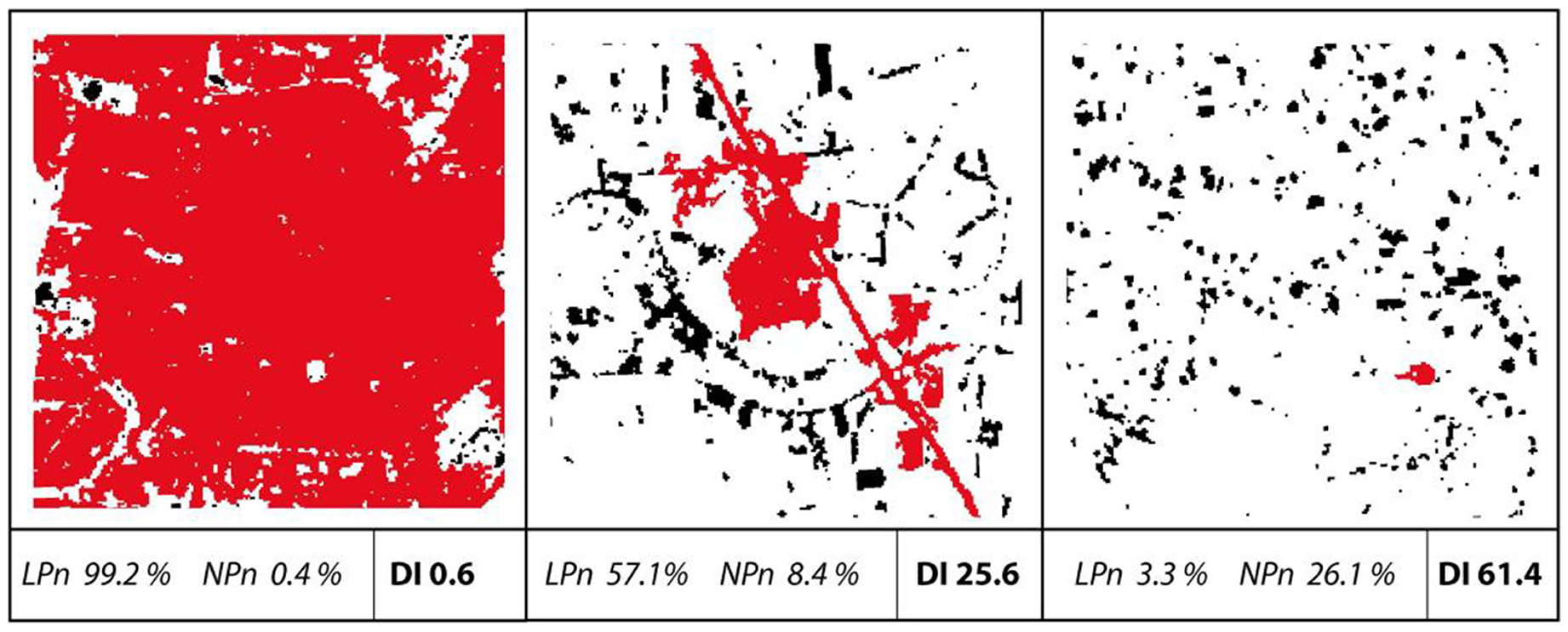
Figure 1. Examples of land use pattern and the related indicators (urbanized land in black, largest patch in red) (Gerten et al., 2019).
As additional measurement for the spatial composition of new land we integrated the share of leapfrog in our analysis concept. Leapfrog refers to newly developed built-up area that are not attached to existing built-up areas (Angel et al., 2016). In our approach, we have set a threshold of 500 m to define these areas. The indicator is the ratio between the leapfrog area and the total newly developed land. Examples of leapfrog in existing settlement structures are shown below.
Expert Interviews
In order to better understand the results of the spatial analysis outlined above, we contacted spatial planners and experts on land development in selected city regions. In online interviews conducted in November and December 2021 we asked a set of standardized central questions, complemented by few region-specific questions and additional complementary background information that came up during the interviews. The two experts for Saint-Petersburg and Krasnodar work for private sector urban planning bureaus with over 10 years of practical experience of research, strategic visioning and territorial planning for the respective cities. The experts for Germany work for regional authorities of the Leipzig region (“West Saxany”) and the Berlin-Brandenburg metropolitan area. Next to the planning expertise we received feedback from a specialist on monitoring applications for regional planning in Berlin-Brandenburg which we incorporated in the results section. All three experts had long-standing experience of over 20 years on the job with responsibilities in policy formulation for urban development, and witnessed post-socialist developments personally and professionally.
The central questions asked for an expert assessment of the land use and population development (see Figure 3 below), which we presented during the interviews. Subquestions asked for an interpretation of the visible trends for urban sprawl dynamics, the underlying drivers of these developments, and potential large projects that could explain distinctive observations (e.g., peaks) in the trendlines. Subsequent questions requested an evaluation of the efficacy of spatial planning instruments to control urbanization since 1990 from the experts, in case such instruments are employed. This also entailed an assessment of acteur constellations and legal mandates for stakeholder participation in the land use decision-making process and its changes over time, which might also be related to reformations of administrative areas and responsibilities. The last question was then modified for the Russian and German experts. The question asked for the changing awareness of civil society and planning practice in relation to urban development outcomes of formerly post-socialist city structures in the respective planning cultures and governance systems.
Results
The result section is divided into four parts. First, we analyze the city regions in a combined dataset, divided by country, to get an overview of the overall population and built-up trends in Russia and Germany. In the second step, we have a detailed look on the dynamics of the selected city regions in each country. Based on this, we choose two city regions per country for an in-depth analysis in the third part of this section. This includes the use of an extended set of indicators, as well as interviews with experts in the field.
Development Trends in Russia and Germany
The analysis starts with the selection of the largest city regions in Germany and Russia. The selection is based on population size of the inner city, with 14 city regions in Germany (over 500,000 inhabitants) and the 26 most populated city regions in Russia. We have decided to exclude Moscow from our analysis, as the size of the city is not comparable to any other city in our sample. Furthermore, Moscow has already been examined in various analyses on growth and urban sprawl (Mason and Nigmatullina, 2011; Kurichev and Kuricheva, 2018; Taubenböck et al., 2019a).
Figure presents a summary graph with the average population and built-up growth between 1990 and 2015 for Russian and German city regions over the travel time rings along the x-axis. For all Russian city regions together, we observe a minor increase of built-up area (0.5%) and a loss of population (−0.4%) in the 15-min ring. Outside the urban core, we identified a significant growth of built-up area. The maximum is in the 45-min ring (1.6%). At the same time, the population has decreased in all rings during this time period. The value range is −0.1 to −0.35% per year. The land use efficiency is therefore negative. In German city regions, we can observe other spatial trends. On average, major German city regions show positive land use efficiency in the 15-min ring. At this point, population growth (0.4%) is higher than built-up growth (0.25%). Between the 15- and 90-min rings, the following trends apply: population growth is decreasing (from 0.4 to 0.05%), and built-up growth is increasing (from 0.25 to 1.05%). In general, the trend here is that growth outside the core city was stronger than population growth between 1990 and 2015. This observation shows that urban sprawl occurs in both countries, with a higher decoupling in Russia.
A detailed look at the single city regions follows in the next section.
Development Trends in Major City Regions
Our results for all Russian city regions in the sample are constituted by the trends of the selected city regions in Figure 2. Almost all city regions show negative land use efficiency for the period from 1990 to 2015 in all travel time rings. The only exception here is St. Petersburg, which has positive efficiency in the 15-, 30-, and 45-min rings. However, even the city regions with consistently negative land use efficiency show differences within the sample. Perm, Tver, and Novokuznetsk are examples with a strongly negative development in the land use efficiency, with the negative peak of land use efficiency at −4. In contrast, city regions such as Krasnoyarsk, Novosibirsk and Sochi have significantly lower values for efficiency. Especially in the area of the core city, the values are significantly below −1.
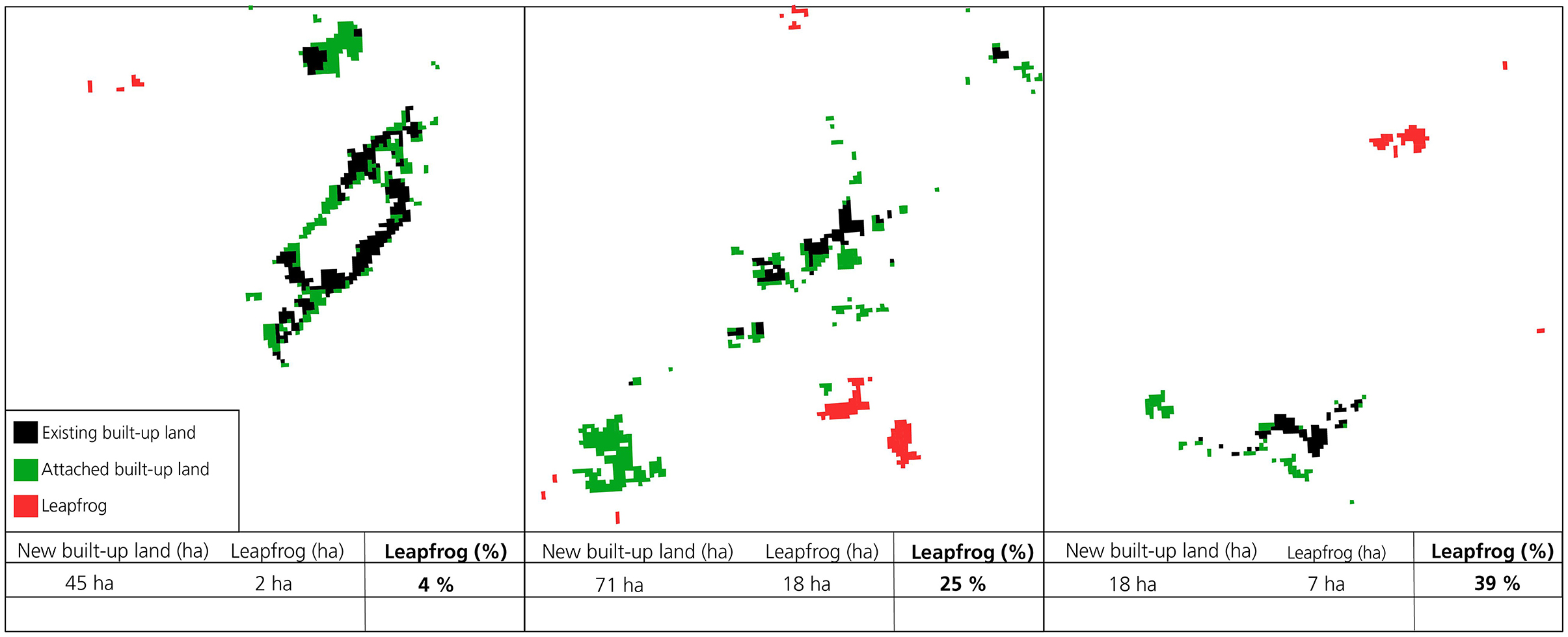
Figure 2. Examples of built-up area compositions and share of leapfrog.
In contrast to the Russian case studies, the German city regions show a more heterogeneous pattern (see Figure 3). We identify city regions in the sample that have predominantly positive land use efficiency. This applies to the largest German city regions (Berlin, Frankfurt, Hamburg, Munich). The two eastern German city regions of Leipzig and Dresden show high negative land use efficiency across all travel time rings. Other city regions with strongly negative values are Hanover, Bremen and Dortmund. Due to the comparably small size of the country and the high density of large city regions, agglomeration effects can emerge in polycentric regions. It is possible that the results include an overlap of travel time rings for city regions in close proximity.
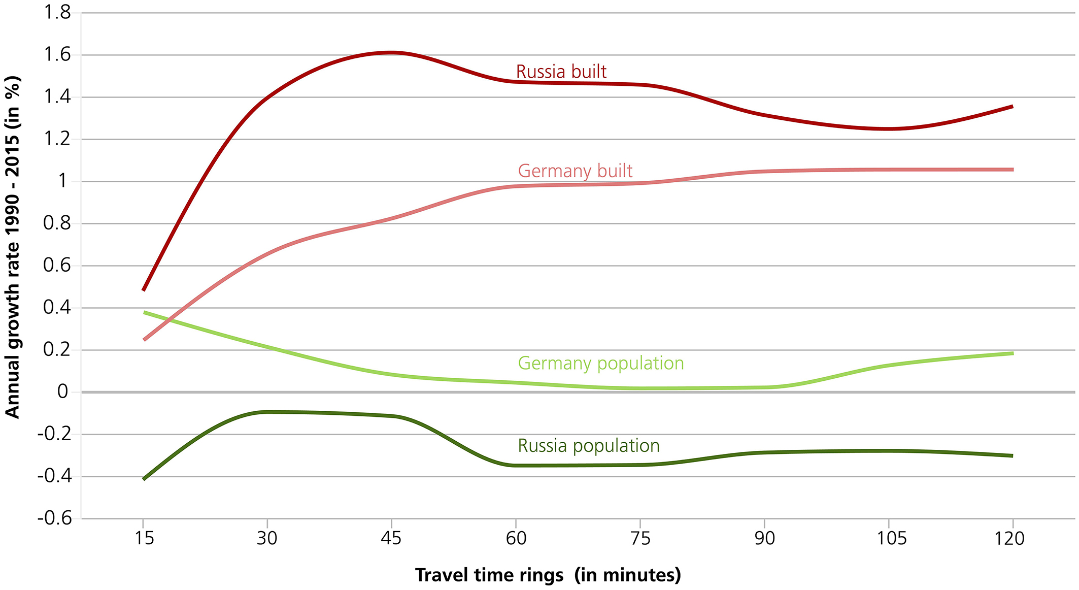
Figure 3. Average built-up and population growth rates for German and Russian city regions between 1990 and 2015 (Graphic: C. Gerten).
In-depth Studies
The aim of the in-depth studies is to identify factors for varying development paths. The selection is based on qualitative (see section Introduction) and quantitative (see Figures 2, 3) aspects. For Germany, we chose Berlin and Leipzig, which are both part of the former GDR but have seen contrasting development paths since 1990: Berlin with (partly) increasing, Leipzig with decreasing land use efficiencies. The Russian city of St. Petersburg, which registered an accelerated population growth over the last decades, serves as a positive example of urban growth. In contrast, Krasnodar shows high negative land use efficiency in comparison to other Russian countries. The selection also considered that the city regions are not exposed to potential effects of polycentricity where neighboring city regions influence the results. For this purpose, we limit the level of observation to the 15-, 30-, 45-, and 60-min rings. The results for all indicators are shown in Figure 6. Table 1 summarizes the information presented in the graphs in a text description and interpretation.

Table 1. Summarized interpretations for the urban metrics by city.
Berlin and Saint-Petersburg on one hand, and Krasnodar and Leipzig on the other hand form comparable pairs by population, while all four city regions have a significant presence of built environment created under socialist planning approaches.
Expert Interviews
The following subsections summarize the explanations expressed by the experts in order to better understand the drivers of the observations presented above and comment on their perception of policy intentions, performance and outcomes.
Russian Experts
For both city regions the experts confirmed the general pattern of urban development discovered in the metrics to compare the development of built-up areas and population: for St.-Petersburg, moderate densification in the city core with an extensive increase of built area in the outskirts, and for Krasnodar general fast increase of built areas. With regard to the graphs, unusual “cross” of red and green lines, more often seen in German urban regions, and discovered in St.-Petersburg, were explained by the experts with the historical status of its core.
The area within the 30-min-ring in Saint-Petersburg was planned and built mostly by European architects according to European examples in the period of 1700–1850. There were less available land plots to add new buildings in the 1990s than in younger Russian city regions. At the same time Saint-Petersburg is well-known in Russia for its relatively strong heritage preservation policies, including UNESCO status (World heritage list). It has an active local community when it comes to architectural heritage. Nevertheless, experts stated that infill development projects took place in the city core. This took place more recently in comparison to other building activities in the city. Regarding the city middle zone (between 30 and 60 min travel zones) transformation, both experts agreed on the explanation related to the redevelopment of old industrial areas.
As Saint-Petersburg was the first industrial city in Russia, the historic center has been surrounded by large industrial enterprises. After the economic stagnation period in the 1990s, many of these factories bankrupted, and their real estate complexes were divided and sold to new owners. “The gray belt,” as this area is often called, is being redeveloped from industrial to commercial and residential use. As former industrial land plots are too large (>100 ha), adaptation and transformation processes occur predominantly along the arterial roads, while the potential of the whole area is underused.
The gray belt in St.-Petersburg is surrounded and intersected by soviet mass housing districts. Infill development in this area took place in the 1990s and still continues at a lower level and is often called “point development intervention” (“tochechnaya zastroika”). It is mostly seen as an example of poor planning, when a single high-rise building appears on a vacant plot without a proper justification of infrastructural limits and parking capability, decreasing quality of the living environment and raising a conflict with the neighborhood local community. Further densification, which is still possible, is related to politically less desirable and economically more expensive solutions in comparison to more distant greenfield alternatives of urban development.
The St.-Petersburg urban agglomeration is located in two administrative areas of the Russian Federation: St.-Petersburg and the Leningrad Region. While the administrative boundary between them was changed several times since 1990, the mental boundary is associated with the circular automobile road (CAD). The expert stated that new development projects right behind the CAD (such as Kudrovo, Murino, Devyatkino residential districts) have earned the sad fame of uncomfortable high-density residential areas, with extreme automobilization rates and a lack of social infrastructure and open spaces (the unofficial term is “chelovejniki,” a neologism with a meaning “human formicary”). Experts pointed out that the calculated urban metrics did not capture the heterogeneity of the peripheral development patterns.
Urban development in the outskirts of St.-Petersburg has shaped different patterns in northern and southern parts of the outer ring. Urban development of the north is driven by big development projects, because it is possible to build high-rise residential districts. Most of these areas in recent decades were built so intensively that there is no place left for important transport interchanges. The south is different, because of the existing network of small towns with a more balanced location of employment. The extension of built areas in the south is often associated with a low-rise development, which is supported by the absence of metro lines and more evident car dependency.
Due to the high recreational attractiveness of the Baltic Sea, land prices along the shoreline are high. New developments are usually more people-oriented on the human scale with smaller buildings of high living quality. Further away from the shoreline new development includes 20-story buildings and higher.
As mentioned by our interview partners, urban sprawl is not an officially confirmed challenge in the Saint-Petersburg agglomeration. However, growth disparities between St.-Petersburg and the Leningrad Region caused the establishment of coordination councils on transport infrastructure and on economic development supported by both regional governments. A common program (“Svetofor”) to strengthen control over building land use was also discussed. Leningrad Region's government took over control on general plans of its municipalities in order to prevent unbalanced and unjustified urban development, which put municipalities in a subordinate position. At the same time there is no officially approved common planning vision for the metropolitan area of St.-Petersburg. The expert from Krasnodar emphasized that during the considered period land administration functions were under command of local authorities, unable to set a metropolitan scale vision.
As the city borough of Krasnodar is a municipality, and not a subject of the Russian Federation like St.-Petersburg, its spatial development has been considered to be an issue of the municipal level. At the same time, within a 1-h-ring from the city center, the Krasnodar agglomeration goes beyond the limits of Krasnodarskij Krai, including settlements in the Republic of Adygea.
The city core of Krasnodar was formed by low-rise buildings at the beginning of the twentieth century. It encompassed single-family urban districts that were organized according to a rectangular grid plan. Due to the agrarian profile of the region, a network of small towns and villages existed around the main city, including the Cossack traditional settlements. During the intensive period of urbanization, the Krasnodar built area expanded mostly in northern and eastern directions. Existing small towns acted as footholds for later extensions, leading to their accretion into a single urban fabric. The expert explained the changes of built area growth ratio with high demand on new housing.
During recent decades, Krasnodar, as a southern big city located relatively close to the warm sea, experienced an outstanding population influx, mostly from northern regions of Russia. In-migration led to an increase of new housing demand. As most of the land properties in Krasnodar and its outskirts after 1990 became privately owned, centrally located low density urban districts confronted uncontrolled densification (such as the Muzykalny district). In general, a large number of land owners in the existing residential areas made negotiations too difficult and risky. At the same time, outside of the city privately owned agricultural land plots were available for legal conversion for urban uses. Due to a weak control over land use and urban development, many housing projects were realized in distant locations, with high density and poor quality. The lack of accessibility with other transport options determined raising car dependency and increasing traffic congestion.
The expert mentioned that development companies, who are also required to build social infrastructure within comprehensive development projects for residential districts, prefer building big schools and kindergartens in order to minimize the number of schools needed according to the building rules. New schools have up to 2,000–3,000 children and new kindergartens have up to 500 children, which assumes a unified unhumanistic character of the whole neighborhood with the use of the worst of soviet features.
The new general plan of Krasnodar, approved in 2020, focuses on single-family housing as the main type of housing in the outskirts. There is currently no approved metropolitan scale strategy for Krasnodar.
German Experts
According to the two German spatial planning experts, a key explanatory factor for the post-socialist land take is “catch-up development.” This process has taken hold in Eastern German city regions in the years immediately after the fall of the Berlin wall when regional planning authorities were yet to be established and spatial planning frameworks non-existent. Figure 4 shows a corresponding increase in the built growth rate, which the experts attributed to structural policies to get rid off incompetive and outdated industries according to Wester German standards and to modernize remaining assets with private and public investments. The new urban land take for these activities dominated the early 1990s. Th process was managed by the development trust (“Treuhand”) of the late GDR which was now under the control of the new federal government.
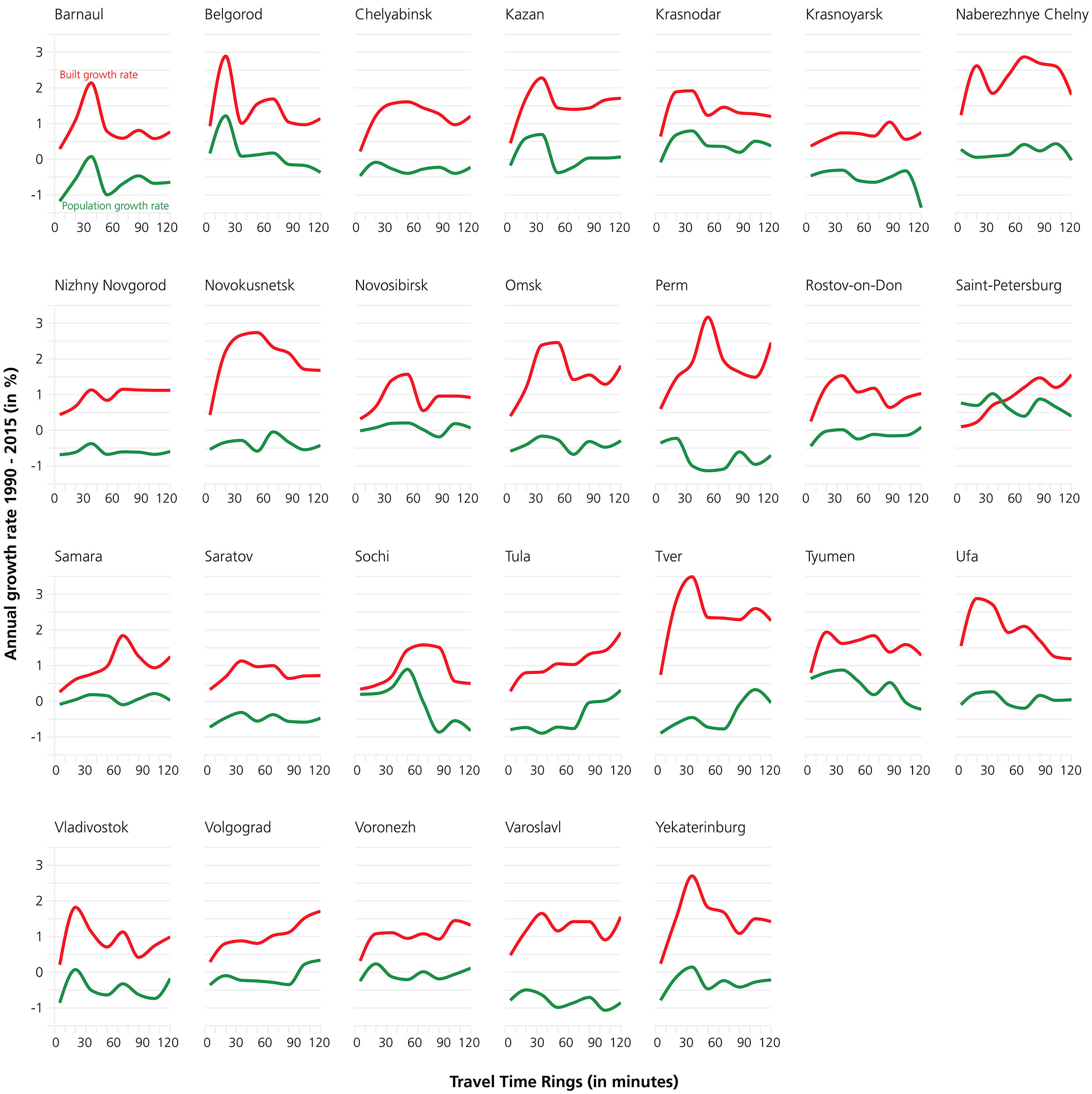
Figure 4. Built-up and population growth rates for selected city regions in Russia (Graphic: C. Gerten).
Figure 4 also shows that both city regions were initially exposed to population decline. The experts explained this picture with the initial outmigration of people and the corresponding decreasing demand for residential housing. They also pointed toward the management problems to restore derelict industrial sites for new construction activities. Berlin as the new national capital and its special situation with a formerly Western German part of the city experienced a trend of population increase much sooner than Leipzig. Initial building activities to provide housing for new arrivals concentrated on the existing housing stock. In the surrounding new municipalities of Brandenburg, housing soon stretched out to suburban locations, giving rise to a decreasing land use efficiency in the peripheral areas of the commutershed (see Figure 6). In 1998, the first state development plan was introduced. It adopted a strict transit-oriented priority for urban development along the main development axes to connect the suburbs with the core city. Development in existing settlements further aways from these axes is formally restricted to the demands of the local population and limited growth allowances (in German: “Eigenentwicklung”) since then. Overall, however, land use decisions are subject to local community planning sovereignty. This means that planning control of urbanization is moderated by local decision-making processes and stakeholder involvement. “Positive planning” designations to direct development to locations with efficient infrastructure provision are therefore complemented by “negative planning” instruments. Designations like greenbelts exert additional spatial planning logic for the subdivision of building activities in self-contained settlements on the regional scale. The benefits of the compact form of these settlements come at the cost of dispersion and leapfrog development between settlements as seen in Figure 5.
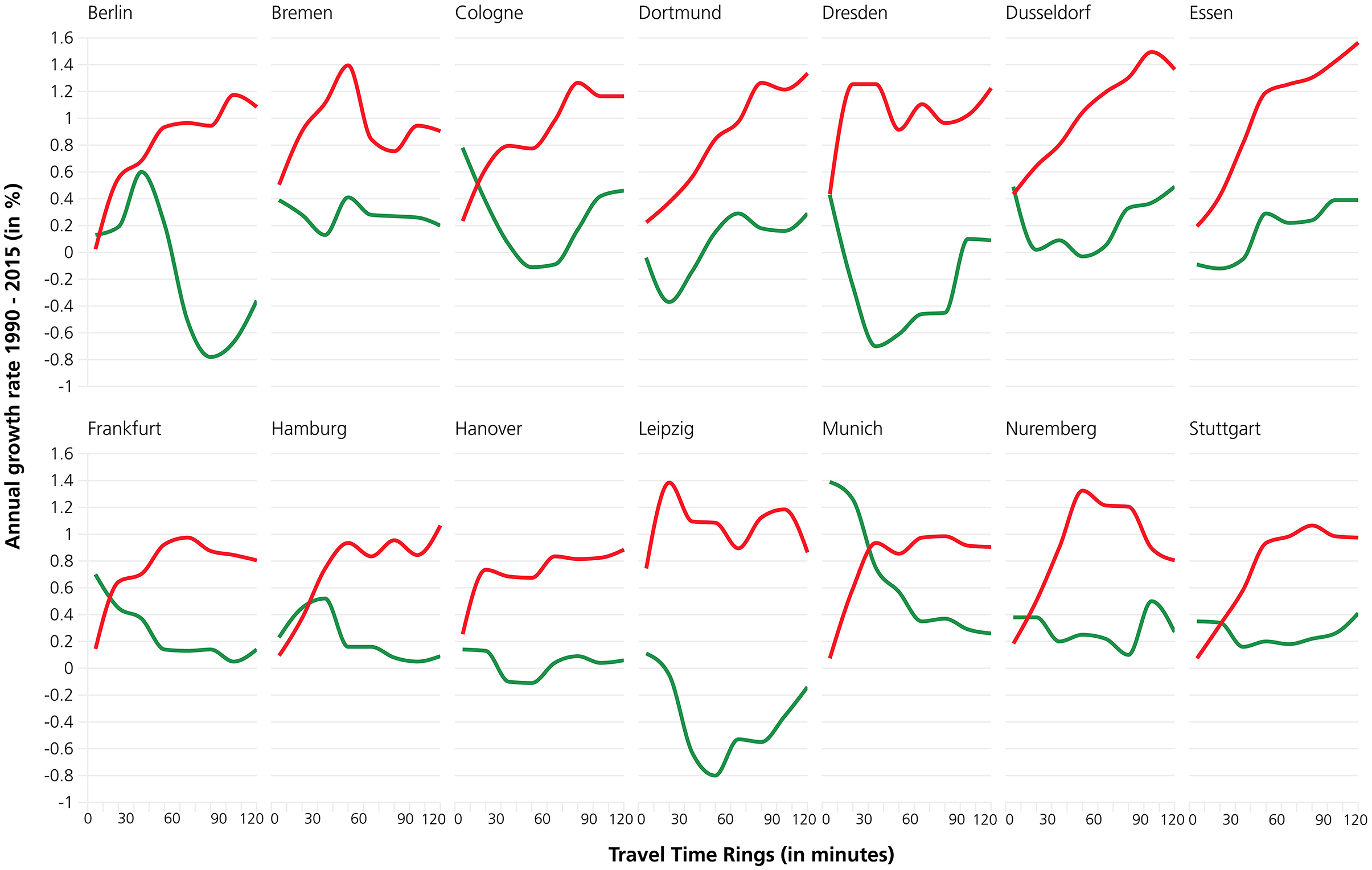
Figure 5. Built-up and population growth rates for selected city regions in Germany (Graphic: C. Gerten).
The City of Leipzig and its surrounding municipalities experienced more drastic out-migration, especially of younger population cohorts. In combination with a plummeting birth rate demographic decline became the dominant trend in the 1990s (see Figure 5). This trend was complemented by decoupled urban development dynamics that were strategically launched to boost and modernize former industrial land assets (e.g., brown coal mining areas) for competetive business activities, new retail and residential locations, large recreational facilities and supporting transport infrastructure. It was only after 2000 that the population in the city stabilized with returning migrants and new arrivals from other parts of Germany and abroad. Development proposals in suburban locations met up with a welcoming and market-friendly planning culture that provided, similar to the Berlin-Brandenburg region, for the swift availability of land resources granted by local planning sovereignty (see the peak in the Leipzig graph of Figure 3). The first state development plan in Saxony (that Leipzig belongs to) has been authorized in 1994. The first regional plan for the area was drafted up until 1998 but only came into force in 2001. The proximity of the neighboring state of Saxony-Anhalt and the nearby City of Halle across the state border influences the development in the Leipzig region. A case in point is the development of the Leipzig/Halle airport and its downstream effect on urban development dynamics.
When asked about the drivers of urban expansion, the expert in Berlin-Brandenburg points toward a phase of reduced development dynamics in the early 2000s where urban development slowed down temporarily (see Figure 5). The attraction of the capital region soon regained pace with international businesses of global exposure and an internationalization of the population. Berlin-Brandenburg has now exhausted many of the (affordable) land resources designated for urban purposes in the state development plan. Continuing demand leads to development pressures further out. Building activities “spill-over” to municipalities in larger distances to the core city, suburban business locations attract their own growth. The expert sees a dominance of market-led urban development that, on the one hand, attracts new arrivals and returnees with a dwelling stock that meets their specific lifestyle preferences. On the other hand, increasing land prices and rents have led to the displacement of not only low-income but also middle-class households. This observation is likely to be reflected in the data analysis presented for the leapfrog and dispersion index in Figure 5, where areas in more than 30 min driving time from the Berlin core experience sharp increases for both indicators.
The impact of large development projects on urban development can be exemplified by many rather uniform single-family homes in suburban municipalities in the Berlin region, accompanied by the large industrial and business developments of the 1990s. The City of Berlin remains the main business hub with most employment opportunities. Suburban locations, however, have been attractive to businesses with large space requirements like logistics. The most prominent example is the recent establishment of a large-scale “giga factory” production facility of an international electric car manufacturer. The expert expects additional building activities in the surroundings of this development in due course. Increasing problems to find office space in the inner city, combined with conflicts with the local population, lead to new drivers of business relocations to suburban municipalities (e.g., IT). The expert explains this process as a cycle that starts with land shortages for businesses and industry in the inner city. Attractive locations become more expensive, businesses with high land demands experience increasing pressure to relocate to the suburbs and beyond. An increased decoupling of land take from population development can therefore be seen in the land use efficiency in Figure 5 in distances beyond 45 min driving time of the core city.
In the Leipzig-West Saxony region, large scale projects in the inner city focused on the demolition or renovation and modernization of vacant pre-fabricated multi-story buildings initially. The town planning objective was to restore urban compactness in the inner city that was lost due to the out-migration of people. It was only after 2000 that especially young population cohorts moved into the city and stabilized the population base, at least in the inner city. Until 2010, most of the vacant dwelling stock came back into use. The city is now engaged in the activation of vacant land to provide infill potentials for new residential dwellings. Old industrial sites and derelict former railway areas are preferred locations. At the same time, suburbanization is driven by a high quality rapid transit system that improves accessibility between nearby subcenters and the central city. It is here where large globally active businesses (e.g., from the domestic automobile sector) drove large-scale developments early on after the reunification, followed by small and large-scale retail businesses. Accessibility by air transport and proximity to the motorway system were seen as locational advantages. For land use efficiency, however, this trend leads to decreased land use efficiency in a much higher magnitude than in Berlin, and higher rates of leapfrog (see Figure 6).
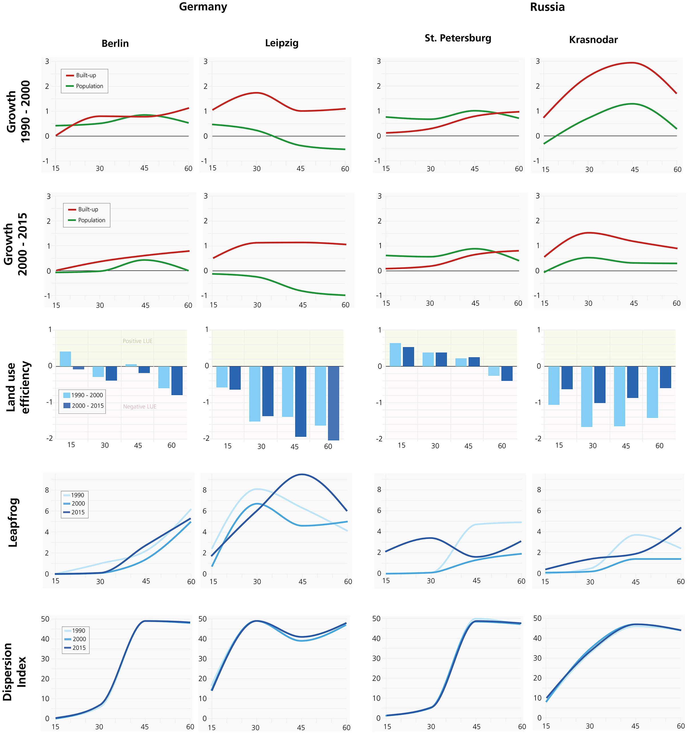
Figure 6. Urban sprawl metrics for Berlin, Leipzig, St. Petersburg and Krasnodar (Graphic: C. Gerten).
Spatial planning in Berlin-Brandenburg implements a radial, transit-oriented spatial design concept for the metropolitan settlement structure. Since 1995, the state planning authorities of Berlin and Brandenburg have a strong mandate to define the spatial details, e.g., for focal points of settlement. The institutional setup, where the states have a rather strong position, has been the same since then. When asked about the performance of spatial planning instruments, the Leipzig expert points toward the successful revitalization and reuse of the vacant building stock, derelict land and infill potentials. The graphs in Figure 5 support this reading for the inner city only. There was hardly any space for additional large-scale residential or business development projects. Such activities had to take place in the suburbs where new multistory block housing emerged in the 1990s mainly in the proximity of public transport stations. This has changed since then. Today, single family homes are the preferred building type in the suburbs, driving leapfrog and dispersion of new land take. In the inner city, city mansions and two-story townhouses were in high demand in the 1990s. Toda, multistory buildings are the preferred building type for new developments, be it for residential or commercial use. The regional plan sets out the basic spatial concepts that are further refined in complementary areal plans. The region engages in research projects on city-regional relationships (“Stadt-Land-Plus”) funded by the federal government to inform these plans. One guiding principle, for example, posits that residential development can only occur along public transport axes with good service quality. The municipalities in the city region have a strong position in the institutional setup of the regional planning authority. Municipalities partly constitute the regional body which represents their combined interests. Regional planning is then responsible to ensure planning control according to regional planning objectives. One problem is the lack of human resources in local planning. Many municipalities struggle to find qualified personnel for this task. In the past, this has frequently led to a form of laisser-faire planning practice for investor-led development projects. The high rates of leapfrog and dispersion in Figure 5 can be interpreted as a result.
The last question about the critical awareness of civil society and spatial planning on post-socialist city development was answered by the Berlin expert with a hint toward the system disruption and the special situation of the formerly divided city. After the fall of the Berlin wall, the focus lay on the core city initially. There was hardly any segregation or suburbanization happening. (Prefabricated) socialist housing supported a social mix with spatial structure and zoning instruments. The suburbanization set in when middle-class households left socialist housing for small suburban single and duplex family homes. The expert speaks of migration motivated by a form of despair, some groups search for a new rural idyll that matches their current lifestyle preferences. The permanent effects of the COVID 19 pandemic that acted as a catalyst for flexible forms of working cannot be fully predicted yet. It is evident though that trends of multi-local living, campaigning for co-working spaces in suburban locations, and digital trends in business activities lead to more flexible work arrangements.
The Leipzig-West Saxony expert pointed out that the building stock in the inner city was never dominated by socialist architecture. It was and is still a rather historic European city, with the exception of the large socialist district in Leipzig Grünau. The reuse of industrial and derelict sites as well as former barracks helped to stabilize the city and combat the demographic decline of the 1990s. Accompanying experiences of social infrastructure closures (e.g., schools and kindergartens) motivated authorities and stakeholders to stop the trends of out-migration and attract new arrivals and returnees. In comparison with Berlin, the data analysis presented in Figures 4, 5 show that Leipzig does not experience the same growth pressures.
Synthesis and Key Takeaways of the Data Analysis and Interviews
Overall, the experts confirmed the trend analysis presented to them in terms of the data analysis conducted for this paper. Their expertise helped to provide explanatory context and insights into the driving factors of urban development.
A synthesis of the data analysis and interviews suggests the following key takeways:
- Post-socialist urban sprawl occurs under both planning systems.
- The main characteristic is a decoupling of population and land use development.
- Initially, outmigration leads to lower land use efficiency, later accompanied by new waves of suburbanization which continues until today.
- “Catch-up” development is an important motivation and justification for laisser-faire building activities in both countries.
- There is no formal regional coordination of urban development in Russia. Developer-led projects can therefore be dispersed and sprawling.
- In Germany, it took a number of years to establish regional coordination of urban development after the fall of the iron curtain. Spatial development plans can conflict with the strong legal empowerment of local municipalities to pursue own interests for designating new urban land uses.
The next section discusses these finding in the light of the literature analysis and future challenges.
Discussion
Similar to the results of Taubenböck et al. (2019a), we observe significant differences in the development trends between German and Russian city regions. Russian city regions are exposed to the post-socialist forces of urban sprawl due to a stronger decoupling of population development from building activities. An exception is St. Petersburg with densification of inner-city districts (<30-min drive time from the center). Planning and design paradigms of Soviet large residential districts influenced the way new residential urban development was realized in Russia after 1990. Inertia of Soviet planning education and practice could be seen in the mechanical spatial organization of residential districts, following the tradition of standardized mass housing. Meanwhile, urban development experienced a change in driving forces: instead of a centralized planning and distribution mechanism, the main driving role in the urban development of the Russian urban agglomerations belongs to private investors. Maximizing profits from real estate investment projects and using existing opportunities of lobbying, they shape the suburban landscape accordingly.
German city regions experience more heterogeneous development paths. Western German city regions, including the reunited Berlin, show convergence of population and built-up growth in proximity to the inner city. In the outskirts, the decoupling trend remains dominant. The reason can be indirectly interpreted from the expert statement that Eastern German city regions had to allow for “catch-up development” after the reunification. This means that most Western German city regions had a more mature urban fabric with consolidated inner cores and suburbs earlier. Post-socialist city regions like Leipzig and Dresden initially lost their compactness due to forces of urban decline in the early 1990s. It was only after 2000 that stabilizing demography and infill development reversed this trend. Urban sprawl in all German city regions continues in suburban rings, although spatial planning concepts direct growth to the central places system and growth nodes along the transport system. This is only partly successful due to stakeholder conflict of interests and the local municipality sovereignty for land-use decisions. Market-induced spillover effects lead to suburban densification not only in growth nodes. Continued metropolization of city regions leads to the formation of new suburbanization rings further out. The catchments of some city regions overlap in the rings furthest out with other city regions. In such locations we also see convergence of population and built-up development.
The GHSL allows us to compare urbanization and sprawl trends in Russia and Germany. With this globally available data on population and built-up area, this layer offers the possibility to compare sustainable urban development worldwide (Melchiorri et al., 2019). But as mentioned in the methodology section, we also need to highlight limitations in the dataset. Based on discussions with experts and previous experience with this dataset, we assume that the population development is valid. However, we found that the development of built-up area in the GHSL does not always match the information of national statistics on land use, especially for German city regions. On average, the growth of built-up area seems to be higher in our analysis. Reasons for this may lie in the misinterpretation of land use and change detections. E.g., areas of raw material extraction or agricultural land are designated as sealed surfaces. The over-coverage is also probably due to the fact that the official land statistics do not have an individual listing for sealed surface. They collect land use information from a nomenclature of land use types that differs substantially from remotely sensed land cover features. Disruptions in the time series of the German official statistics are a well-known issue. False detections in remote sensing, however, cannot be ruled out as a source of error.
The results of this paper showcase how the spatial sciences can bridge the gap between knowledge generation based on spatial analysis and the interpretation of monitoring results in planning practice. Methodological advancement is urgently needed in urban sprawl research to transfer knowledge about potentially negative development outcomes to the early planning stages. It is at this stage where decision-making sets out the paths for future urban structures, frequently in an irreversible way. Sprawling city regions are ill-prepared for the pressing tasks of carbon-neutral and less car dependant lifestyles and business activities if they neglect the necessity to work toward compact urban form and higher land use efficiency.
Insights into planning practice, however, are also important for spatial science to understand the conditions under which planning operates in different governance regimes like Russia and Germany. Such insights are important to learn about the information requirements to monitor trends and evaluate the efficacy of policies and planning instruments.
This paper shows an approach that works on the metropolitan level, visualizes trends for ease of communication and acknowledges the functional relationships between cities and their catchments. Limitations are that small-scale land use changes for infill development, which are important for planning practice to cater for growth without further sprawl, only take effect in a cumulative way. This limitation can be overcome with location-specific land use changes published in interactive maps in web portals. The authors are currently preparing a web portal for this purpose for German city regions. This could be extended to other countries like Russia in due course.
Data Availability Statement
Publicly available datasets were analyzed in this study. This data can be found at: https://ghsl.jrc.ec.europa.eu/datasets.php.
Author Contributions
CG has sourced the data for this project, developed the indicator concept, and conducted the spatial analysis. DB and SF have provided the information on the governance of post-socialist spatial development in Russia and Germany (Introduction and Discussion), respectively. All authors have contributed to formulate the research question for this paper and conducted the expert interviews.
Conflict of Interest
DB is employed by GeoClever Ltd.
The remaining authors declare that the research was conducted in the absence of any commercial or financial relationships that could be construed as a potential conflict of interest.
Publisher's Note
All claims expressed in this article are solely those of the authors and do not necessarily represent those of their affiliated organizations, or those of the publisher, the editors and the reviewers. Any product that may be evaluated in this article, or claim that may be made by its manufacturer, is not guaranteed or endorsed by the publisher.
Footnote
References
Albrech, J., Fink, P., and Tiemann, H. (2016). Ungleiches Deutschland. Sozioökonomischer Disparitätenbericht 2015. Bonn: Friedrich-Ebert-Foundation.
Andersson, L.-F., Bengtsson, H., Fina, S., and Heider, B. (2021). Unequal Sweden. Regional Socio-Economic Disparities in Sweden. Stockholm: Friedrich-Ebert-Foundation.
Angel, S., Blei, A. M., Parent, J., Lamson-Hall, P., and Sanchez, N. G. (2016). Atlas of Urban Expansion - 2016 Edition. Volume 1: Areas and Densities. Cambridge: Lincoln Institute of Land Policy.
Antonov, E. V., and Makhrova, A. G. (2019). Largest urban agglomerations and forms of settlement above the agglomeration level in Russia [Krupneyshie gorodskie aglomeratsii i formyi rasseleniya nad aglomeratsionnogo urovnya v Rossii]. Izvestiya RAN. Seriya geographicheskaya 2019, 31–45. doi: 10.31857/S2587-55662019431-45
Breslavsky, A. S. (2014). Unplanned Suburbs: Rural-Urban Migration and the Growth of Ulan-Ude in the Post-Soviet Period [Nezaplanirovannye prigorody: selsko-gorodskaya migratsiya i rost Ulan-Ude]. Ulan Ude: Publishing House of BSCSBRAS.
Couch, C., Karecha, J., Nuissl, H., and Rink, D. (2005). Decline and sprawl. An evolving type of urban development - observed in Liverpool and Leipzig. Euro. Plann. Stud. 13, 117–136. doi: 10.1080/0965431042000312433
DCLG. (2017). The Town and Country Planning (Brownfield Land Register) Regulations. London: Department for Communities and Local Government (DCLG).
Decoville, A., and Schneider, M. (2016). Can the 2050 zero land take objective of the EU be reliably monitored? A comparative study. J. Land Use Sci. 11, 331–349. doi: 10.1080/1747423X.2014.994567
Dembski, S., Sykes, O., Couch, C., Desjardins, X., Evers, D., Osterhage, F., et al. (2019). Reurbanisation and suburbia in Northwest Europe. A comparative perspective on spatial trends and policy approaches. Progress Plann. 150, 1–47. doi: 10.1016/j.progress.2019.100462
Die Bundesregierung (2021). Deutsche Nachhaltigkeitsstrategie. Weiterentwicklung 2021. Berlin: Die Bundesregierung.
EEA (2006). Urban sprawl in Europe. The Ignored Challenge. EEA Report No 10/2006. Copenhagen: European Environment Agency.
EEA (2019). State of the Environment Report 2020. Knowledge for Transition to a Sustainable Europe. Copenhagen: European Environment Agency.
ESPON (2020a). SUPER-Sustainable Urbanization and Land-Use Practices in European Regions. Draft FinalReport. Luxembourg: ESPON.
ESPON (2020b). SUPER-Sustainable Urbanization and Land-Use Practices in European Regions. Annex 3.1. Luxembourg. ESPON.
Esri (2019). ArcGIS-Online - Network Analysis Coverage. Available online at: https://doc.arcgis.com/en/arcgis-online/reference/network-coverage.htm (accessed December 31, 2021).
Esswein, H., Jaeger, J., Schwarz-von Raumer, H.-G., and Müller, M. (2002). Landschaftszerschneidung in Baden-Württemberg. Stuttgart: Akademie für Technikfolgenabschätzung.
Ewing, R. (1997). Is Los Angeles-style sprawl desirable? J. Am. Plann. Assoc. 63, 107–126. doi: 10.1080/01944369708975728
Ewing, R., Meakins, G., Hamidi, S., and Nelson, A. C. (2014). Relationship between urban sprawl and physical activity, obesity, and morbidity - update and refinement. Health Place 26, 118–126. doi: 10.1016/j.healthplace.2013.12.008
Ewing, R., Pendall, R., and Chen, D. (2013). Measuring Sprawl and Its Impact. Washington, DC: Smart Growth America.
Ewing, R., and Rong, F. (2008). The impact of urban form on U.S. residential energy use. Housing Policy Debate 19, 1–30. doi: 10.1080/10511482.2008.9521624
Fina, S. (2013). Indikatoren der Raumentwicklung. Flächeninanspruchnahme und Landschaftszersiedelung (Dissertation). Eberhard Karls Universtität, Tübingen, Germany.
Fina, S. (2021). Nachhaltigkeitslücke Landschaftszersiedelung. Berichte Geographie und Landeskunde 94, 278–299. doi: 10.25162/bgl-2021-0014
Fina, S., Heider, B., and Masso, M. (2021a). Unequal Estonia. Regional Socio-Economic Disparities in Estonia. Riga. Friedrich-Ebert-Foundation.
Fina, S., Heider, B., Mattila, M., Rautiainen, P., Sihvola, M.-W., and Vatanen, K. (2021b). Unequal Finland. Regional Socio-Economic Disparities in Finland. Stockholm: Friedrich-Ebert-Foundation.
Fina, S., Heider, B., and Prota, F. (2021c). Unequal Italy. Regional Socio-Economic Disparities in Italy. Rome: Friedrich-Ebert-Foundation.
Fina, S., Heider, B., and Rat, C. (2021d). Unequal Romania. Regional Socio-Economic Disparities in Romania. Bucharest: Friedrich-Ebert-Foundation.
Fina, S., Osterhage, F., Rönsch, J., Rusche, K., Siedentop, S., Volgmann, K., et al. (2020). “Monitoring StadtRegionen,” in Jahrbuch StadtRegion 2019/2020: Schwerpunkt: Digitale Transformation, eds C. Hannemann, F. Othengrafen, J. Pohlan, B. Schmidt-Lauber, R. Wehrhahn, and S. Güntner (Wiesbaden: Springer Fachmedien), 225–288.
Fina, S., Osterhage, F., Rönsch, J., Rusche, K., Siedentop, S., Zimmer-Hegmann, R., et al. (2019). Ungleiches Deutschland. Sozioökonomischer Disparitätenbericht 2019. Karten, Indikatoren und wissenschaftliche Handlungsempfehlungen. Berlin: Friedrich-Ebert-Foundation.
Frenkel, A., and Ashkenazi, M. (2008). Measuring urban sprawl: how can we deal with It? Environ. Plann. B 35, 56–79. doi: 10.1068/b32155
Friedrich, M., Birkmann, J., Fina, S., Rönsch, S., Feldmeyer, D., Valleé, D., et al. (2017). Überprüfung und Weiterentwicklung des Instrumentariums zur Koordination von Siedlungs- und Verkehrsentwicklung vor dem Hintergrund erforderlicher CO2-Reduktion und der demografischen Entwicklung für die Region Stuttgart. Stuttgart: Verband Region Stuttgart.
Frost, I. (2018). Exploring varieties of (post)Soviet urbanization: reconciling the general and particular in post-Socialist urban studies. Europa Regional 25, 2–14.
Gerten, C., Fina, S., and Rusche, K. (2019). The sprawling planet: simplifying the measurement of global urbanization trends. Front. Environ. Sci. 7, 140. doi: 10.3389/fenvs.2019.00140
Girvetz, E., Jaeger, J., and Thorne, J. (2007). Comment on 'roadless space of the conterminous United States'. Science 318, 1240. doi: 10.1126/science.1145349
Glazychev, V. L. (2011). Limitless City. [Gorod bez granits]. Moscow: Publishing House 'Territory of the Future'.
Golubchikov, O. (2006). Interurban development and economic disparities in a Russian province. Eurasian Geogr. Econ. 47, 478–495. doi: 10.2747/1538-7216.47.4.478
Grigorichev, K. V. (2013). In the Shadow of a Large City. Social Space of Suburbia [V teni bolshogo goroda. Socialnoye prostranstvo prigoroda]. Irkutsk: Ottisk.
Haase, A., Rink, D., Grossmann, K., Bernt, M., and Mykhnenko, V. (2014). Conceptualizing urban shrinkage. Environ. Plann. A 46, 1519–1534. doi: 10.1068/a46269
Hasse, J. E., and Lathrop, R. G. (2003). Land resource impact indicators of urban sprawl. Appl. Geogr. 23, 159–175. doi: 10.1016/j.apgeog.2003.08.002
Hennings, A. (2021). SDGs: Indicator 11.3.1. Ratio of Land Consumption Rate to Population Growth Rate. Avialble online at: https://landportal.org/node/52272 (accessed December 16, 2021).
Hirt, S. (2013). Whatever happened to the (post) socialist city? Cities 32, 29–38. doi: 10.1016/j.cities.2013.04.010
Hirt, S., and Stanilov, K. (2009). Twenty Years of Transition: The Evolution of Urban Planning in Eastern Europe and the Former Soviet Union, 1989-2009. Nairobi: UN Habitat.
Ianoş, I., Sîrodoev, I., Pascariu, G., and Henebry, G. (2016). Divergent patterns of built-up urban space growth following post-socialist changes. Urban Stud. 53, 3172–3188. doi: 10.1177/0042098015608568
Jaeger, J., Bertiller, R., Schwick, C., and Kienast, F. (2009). Suitability criteria for measures of urban sprawl. Ecol. Indicat. 10, 397–406. doi: 10.1016/j.ecolind.2009.07.007
Jaeger, J., and Schwick, C. (2014). Improving the measurement of urban sprawl. Weighted Urban Proliferation (WUP) and its application to Switzerland. Ecol. Indicat. 38, 294–308. doi: 10.1016/j.ecolind.2013.11.022
Jaeger, J., Schwick, C., Bertiller, R., and Kienast, F. (2008). Landschaftszersiedelung Schweiz - Quantitative Analyse 1935 bis 2002 und Folgerungen für die Raumplanung. Wissenschaftlicher Abschlussbericht. Schweizerischer Nationalfonds, Nationales Forschungsprogramm NFP 54 Nachhaltige Siedlungs- und Infrastrukturentwicklung, Zürich, Germany.
Jansen, H., Roost, F., and Wünnemann, M. (2016). “Suburbane nutzungsmischung?,” in Informationen zur Raumentwicklung, 289–301.
JRC (2016). Operating Procedure for the Production of the Global Human Settlement Layer From Landsat Data of the Epochs 1975, 1990, 2000, and 2014. Copenhagen: JRC Publications Office.
Kabakova, S. I. (1973). Urban Planning Assessment of Urban Areas [Gradostroitelnaya otsenka territorij gorodov]. Moscow: Strojizdat.
Keil, M., Bock, M., Esch, T., Metz, A., Nieland, S., and Pfitzner, A. (2010). CORINE Land Cover Aktualisierung 2006 für Deutschland. Wessling: Deutsches Fernerkundungsdatenzentrum.
Keil, M., Kiefl, R., and Strunz, G. (2004). CORINE Land Cover 2000 - Europaweit harmonisierte Aktualisierung der Landnutzungsdaten für Deutschland. Wessling: Deutsches Fernerkundungsdatenzentrum.
Keil, R. (2017b). Suburban Planet. Making the World Urban From the Outside in. London: John Wiley & Sons.
Keil, R., and Ren, X. (2017a). “Global suburbanization,” in The Globalizing Cities Reader (London: Routledge), 433–440.
Kroll, F., and Haase, D. (2010). Does demographic change affect land use patterns? A case study from Germany. Land Use Policy 27, 726–737. doi: 10.1016/j.landusepol.2009.10.001
Kurichev, N. K., and Kuricheva, E. K. (2018). Relationship of housing construction in the moscow urban agglomeration and migration to the metropolitan area. Reg. Res. Russ. 8, 1–15. doi: 10.1134/S2079970518010069
Lang, R. E. (2000). Office Sprawl. The Evolving Geography of Business. Washington, DC: The Brookings Institution.
Lappo, G. M., and Polyan, P. M. (1999). Urbanization Results in Russia by the End of XX Century [Rezultaty urbanizatsii v Rossii k kontsu XX veka]. Moscow: Mir Rossii.
Lukhmanov, D. N. (1996). Settlement structure of rural Russia: recent decades' changes. [Poselencheskaya i rasselencheskaya struktura sel'skoi Rossii: izmeneniya poslednikh let]. Vestnik Evrazii 2, 18–30.
Maleeva, T. V. (2005a). Land Use Problems in Large Cities. [Problemy zemlepolzovaniya v krupnykh gorodakh]. Problemy sovremennoj economiki 1/2 (13/14). Availble online at: http://www.m-economy.ru/art.php?nArtId=718 (accessed December 20, 2021).
Maleeva, T. V. (2005b). Issues of land use in large cities. [Problemy zemlepolzovaniya v krupnykh gorodakh]. Problemy sovremennoj economiki, 1/2 (13/14), p. 295–298.
Mason, R. J., and Nigmatullina, L. (2011). Suburbanization and sustainability in metropolitan Moscow. Geograph. Rev. 101, 316–333. doi: 10.1111/j.1931-0846.2011.00099.x
McGarigal, K., and Marks, B. J. (1995). FRAGSTATS. Spatial Pattern Analysis Program for Quantifying Landscape Structure. Portland: USDA Forest Service, Pacific Northwest Research Station.
Meerovich, M. G. (2015). The uniqueness of urbanization in the USSR. [Unikalnost' urbanizatsii v SSSR]. Vestnik TGASU 2015, 9–16.
Melchiorri, M., Pesaresi, M., Florczyk, A., Corbane, C., and Kemper, T. (2019). Principles and applications of the global human settlement layer as baseline for the land use efficiency indicator - SDG 11.3.1. IJGI 8, 96. doi: 10.3390/ijgi8020096
Mössner, S., Freytag, T., and Miller, B. (2018). Die Grenzen der Green City. Die Stadt Freiburg und ihr Umland auf dem Weg zu einer nachhaltigen Entwicklung? Planung neu denken, 1–8. Availble online at: http://www.planung-neu-denken.de/ (accessed January 24, 2018).
Nuissl, H., and Rink, D. (2003). Urban Sprawl and Post-Socialist Transformation. The case of Leipzig (Germany). UFZ-Report 4/2003, Leipzig, Germany.
Nuissl, H., and Rink, D. (2005). The 'production' of urban sprawl in eastern Germany as a phenomenon of post-socialist transformation. Cities 22, 123–134. doi: 10.1016/j.cities.2005.01.002
Pagonis, T., and Thornley, A. (2000). Urban development projects in Moscow: market/state relations in the new Russia. Euro. Plann. Stud. 8, 751–766. doi: 10.1080/713666440
Pesaresi, M., Huadong, G., Blaes, X., Ehrlich, D., Ferri, S., and Gueguen, L. (2013). A global human settlement layer from optical HR/VHR RS data: concept and first results. IEEE J. Sel. Top. Appl. Earth Observ. Remote Sens. 6, 2102–2131. doi: 10.1109/JSTARS.2013.2271445
Polyan, P., Nefyodova, T., and Treyvish, A. (2001). City and Village in European Russia: A Hundred Years of Changes. [Gorod i derevnya v Evropeiskoj Rossii: sto let peremen]. Moscow: OGI. Available online at: http://www.demoscope.ru/weekly/knigi/gorod/gorod.html (accessed December 20, 2021).
Schiavina, M., Melchiorri, M., Corbane, C., Florczyk, A., Freire, S., Pesaresi, M., et al. (2019). Multi-scale estimation of land use efficiency (SDG 11.3.1) across 25 years using global open and free data. Sustainability 11, 5674. doi: 10.3390/su11205674
Schmidt, S. (2011). Sprawl without growth in eastern Germany. Urban Geogr. 32, 105–128. doi: 10.2747/0272-3638.32.1.105
Schmidt, S., Fina, S., and Siedentop, S. (2014). Post-socialist sprawl. A cross-country comparison. Euro. Plann. Stud. 23, 1–26. doi: 10.1080/09654313.2014.933178
Schwarz, N., Haase, D., and Seppelt, R. (2009). Omnipresent sprawl? A review of urban simulation models with respect to urban shrinkage. Environ. Plann. B 37, 265–283. doi: 10.1068/b35087
Siedentop, S., and Fina, S. (2010). Urban sprawl beyond growth. The effect of demographic change on infrastructure cost. Flux 79/80, 90–100. doi: 10.3917/flux.079.0090
Siedentop, S., Heiland, S., Lehmann, I., and Schauerte-Lüke, N. (2007). Nachhaltigkeitsbarometer Fläche. Regionale Schlüsselindikatoren nachhaltiger Flächennutzung für die Fortschrittsberichte der Nationalen Nachhaltigkeitsstrategie - Flächenziele. Bonn: Bundesamt für Bauwesen und Raumordnung.
Siedentop, S., Junesch, R., Strasser, M., Zakrzewski, P., Samaniego, L., and Weinert, J. (2009). Einflussfaktoren der Neuinanspruchnahme von Flächen. Bonn: Bundesamt für Bauwesen und Raumordnung.
Soule, D. C. (2006). Urban Sprawl: A Comprehensive Reference Guide. Westport, CT: Greenwood Publishing Group.
Stanilov, K. (2007). The Post-Socialist City: Urban Form and Space Transformations in Central and Eastern Europe After Socialism. Luxembourg: Springer Science & Business Media.
Stanilov, K., and Sýkora, L. (2014). Confronting Suburbanization: Urban Decentralization in Postsocialist Central and Eastern Europe. New York, NY: John Wiley & Sons.
Steinführer, A., Porsche, L., and Sondermann, M., (eds.) (2019). Positionspapier Kleinstadtforschung. Hanover: Akademie für Raumforschung und Raumplanung.
Sỳkora, L. (2009). Post-socialist cities. Int. Encycl. Human Geogr. 8, 387–395. doi: 10.1016/B978-008044910-4.01072-5
Taubenböck, H., Gerten, C., Rusche, K., Siedentop, S., and Wurm, M. (2019a). Patterns of Eastern European urbanisation in the mirror of Western trends - convergent, unique or hybrid? Environ. Plann. B Urban Anal. City Sci. 46, 1206–1225. doi: 10.1177/2399808319846902
Taubenböck, H., Wurm, M., Geiß, C., Dech, S., and Siedentop, S. (2019b). Urbanization between compactness and dispersion: designing a spatial model for measuring 2D binary settlement landscape configurations. Int. J. Digital Earth 12, 679–698. doi: 10.1080/17538947.2018.1474957
Tikoudis, I., Farrow, K., Mebiame, R. M., and Oueslati, W. (2022). Beyond average population density: measuring sprawl with density-allocation indicators. Land Use Policy 112, 1–18. doi: 10.1016/j.landusepol.2021.105832
Tsai, Y.-H. (2005). Quantifying urban form: compactness versus 'sprawl'. Urban Stud. 42, 141–161. doi: 10.1080/0042098042000309748
United Nations (2016). Transforming Our World: The 2030 Agenda for Sustainable Development. A/RES/70/1. New York, NY: United Nations.
Vishnevsky, A. G. (1998). Sickle and Ruble. Conservative Modernization in the USSR [Serp i rubl. Konservativnaya modernizatsiya v SSSR]. Moscow: OGI.
WBGU (2016). Der Umzung der Menschheit. Die transformative Kraft der Städte. Hauptgutachten. Berlin. WBGU.
WBGU (2019). Wissenschaftlicher Beirat der Bundesregierung Globale Umweltveränderungen. Unsere gemeinsame digitale Zukunft. Hauptgutachten. Berlin: WBGU.
Keywords: urban sprawl, spatial indicators, post-socialist urban development, sustainable development, urban governance, Germany, Russia
Citation: Gerten C, Boyko D and Fina S (2022) Patterns of Post-socialist Urban Development in Russia and Germany. Front. Sustain. Cities 4:846956. doi: 10.3389/frsc.2022.846956
Received: 31 December 2021; Accepted: 25 March 2022;
Published: 19 April 2022.
Edited by:
Malgorzata Renigier-Biłozor, University of Warmia and Mazury in Olsztyn, PolandReviewed by:
Lorenzo De Vidovich, University of Trieste, ItalyHan Li, University of Miami, United States
Copyright © 2022 Gerten, Boyko and Fina. This is an open-access article distributed under the terms of the Creative Commons Attribution License (CC BY). The use, distribution or reproduction in other forums is permitted, provided the original author(s) and the copyright owner(s) are credited and that the original publication in this journal is cited, in accordance with accepted academic practice. No use, distribution or reproduction is permitted which does not comply with these terms.
*Correspondence: Stefan Fina, c3RlZmFuLmZpbmFAaWxzLXJlc2VhcmNoLmRl