 Mehdi Saqalli1*
 Abdelkarim Hamrita2,3
 Hassane Mouri4
 Hichem Rejeb3Moulay Lâarabi El Hachimi5El Mehdi Benyassine6
 Nasser Rebaï7
- 1UMR 5602 GEODE (Environment Geography Lab), CNRS-Université Toulouse 2 Jean Jaurès, Toulouse, France
- 2Departamento de Geografía, Universidad Autónoma de Madrid, Madrid, Spain
- 3Institut Supérieur Agronomique Chott-Meriem, Université de Sousse, Sousse, Tunisia
- 4Université Tunis El-Manar, Tunis, Tunisia
- 5Géosciences et environnement, CRMEF, Rabat, Morocco
- 6Géo-explorations et Géotechniques, Université de Meknès, Meknès, Morocco
- 7Université Sorbonne Paris Nord (USPN), Villetaneuse, France
Mediterranean mountains have been and continue to be used by human populations along an interweaving of numerous uses: agro-sylvo-pastoralism, trade, industry and mining have all gone hand in hand for several millennia. Mines are however a so important source of wealth that, by putting in contact external powers and mountain locals, it creates an imbalance of powers inducing structural violence and tensions. The 1830–1962 colonial era did change the magnitude of these imbalances and this affect all Mediterranean mountainous ranges. The French expansion did affect as a result the Moroccan Atlas, the Tunisia Coastal Mounts but also the French Pyrenees. The article explores the available archives regarding the history of three mines in each of these emblematic mountains with a shared mining and agro-sylvo-pastoral past and where mining were actually well-known: Sem-Rancié and Puymorens in the French Pyrenees, Mibladen and Zeïda in the Moroccan Middle Atlas and Jebel Ressass in Tunisia. These reconstructions show that the initial social and political situations, as diverse as they are, are of little importance in the trajectory of these mines: all of them see a rapid appropriation by economic powers that are more and more powerful and more and more distant as far as Paris, the common capital in colonial times, despite several revolts and tensions. The initial expansion then gave way to a structural crisis due to the competition with other mining sites until abandonment. The following powers, post-colonial in Morocco or Tunisia or decentralized in France, did not endorse any responsibility of this the post-mining environmental, social and economic legacy. For each of these sites, the mine could be seen as an indicator of the power balance evolution among activities and actors, a canary in the mine on which we propose a methodology for further investigations.
Introduction
The Mediterranean mountains are particular ones in that they have been occupied and used since the Neolithic and have never been isolated from the plain and the Mediterranean coast, which are often very close. It has been a connected refuge or an antagonist of this plain and this coast, in and around which powerful civilizations have resided. This connection gives additional relief and magnitude to the various and numerous uses of the Mediterranean mountain ranges, which have intertwined, complemented or even opposed themselves over the course of time: agro-sylvo-pastoralism, trade, industry and mining have all gone hand in hand for several millennia. Mountain land issues most often refers to three dominant local activities: pastoralism (because it is the major cover in extensive areas), forestry (as it is currently the most extensive in low-density regions) and agriculture (because it constitutes the vital point of sustainability for mountain agropastoralist populations). These three uses are practiced in a gradation of increasing export, from food to income,1 with an inversely proportional required manpower devoted to each industry,2 reconstituting the classic sequence of events in Mediterranean rural decline.
Mines are the fourth use that should be considered. Operations are almost entirely cash based, very labor intensive and capital intensive, inducing a strong local social impact and a strong dependence on funding places, namely plain and coastal cities. Above all, they are the most immediately profitable and therefore the most coveted investment in a region. They are therefore a source of wealth for mountain areas that are often less fortunate than the plains, but they also represent a significant social, political and economic risk, along an inevitable environmental impact.3 The 19th and 20th centuries saw a change in the magnitude of this industry in many Mediterranean countries, driven by the needs for mining products of Mediterranean colonial powers such as France. Several companies launched mining programmes, all of which are now abandoned but whose slag heaps are still visible. The social, economic and environmental impacts on societies and territories are directly linked to the rights of mining and agropastoralist communities to manage and appropriate mining income, but also to the combination of this income with the rights of use for other activities: agriculture, livestock breeding and forestry. Who decides and who owns determines the future of mining activity and its impact.
At its foundation, mountainous access to resources, due to the history and the number of actors accumulated, is not simple: it is the place of a more or less peaceful cohabitation of intertwined land tenure and legal regimes.4 Observing mountain communities therefore implies considering complex legal situations. This intertwining cannot be understood without making the link to inequalities in access to land, whatever the development model, the land policy and the nation considered. Indeed, as one might expect, the best farmland were generally monopolized by the dominant powers of the time, including settlers during colonization (Bourdet, 1952; Dupont, 1952), or large families, heirs and even the state itself afterwards, to the detriment of the local residents, peasants or herders (Garmy, 1963; Balent, 2005).5
However, the wealth inequality is found in mining in an exacerbated manner. Our hypothesis is that this concentration of wealth crystallizes the tension over resources, and between actors who would otherwise remain distant as resources are scattered, contacts are rare, and stakes are otherwise usually low in such territories. Consequently, subsoil resources necessarily involves land appropriations and by then often opposes local actors and powers with strong capital resources, who are almost always external to the mountain. Telling the story of mines, particularly in the Mediterranean, is thus telling the story of confrontations, conflicts, arrangements and negotiations between often dissymmetrical actors. As mining is among the activities that bring in the most money, related situations are ones where appetites and power relations are strong, possibly leading to military conquests. It is in essence a politically violent situation.
Finally, the strategic importance of mines in local, national or imperial/colonial history obviously involves actors beyond the simple tension between the local population and external private parties. The national or imperial public authority may become the legitimizing and most often armed branch of outside investors, but it also finds itself in a position where it must legitimize itself or else be challenged as a refereeing power. Finally, we postulate, without any ideological populism, that the local population is almost never a united whole. The dynamics of these mines, their management and their abandonment requires the integration of local powers, most often the local oligarchy whose interests are not necessarily in alignment with the rest of the population, to say the least.
To consider these postulates, we analyse in this article three contemporary Mediterranean mines, which we think are representative of their corresponding mountainous ranges. They all involved equivalent actor categories: public authorities, private actors, local oligarchy and the population. The article presents the characteristics and histories of these mines in France, Morocco and Tunisia. From these apparently dissimilar case histories, we draw the common features from the trajectories of these environmental and social objects, which we link first to the legal confusion, by no means fortuitous, that they represent and to the costs of environmental management as measured against the financial gains that they generated during the period of their activities. The conclusion leads us to a proposal for comparative research into the reorganization of the uses of the Mediterranean mountains around these mines, research that must include environmental, socio-political and legal dimensions. The novelty of the approach resides in its progressive articulation between disciplines: this first historical approach allows a prospective over the political future of present-time mines and surrounding territories because of the catalyst and warning effect of mines. The final proposal we envision at the end of the article may then formalize more quantitatively and spatially the evolution of these balance of powers with subsequent results on socio-environmental dynamics of mountainous and mining territories.
Methods of investigation
The three sites were chosen according to their dispersion along Western Mediterranean shores, including the fact that they belong to mountainous locations. They were also considered the most important abandoned mines within their region and within the expertise of the co-authors of the article, having extensively worked on one or several selected sites (EL El Hachimi et al., 2014; Hamrita et al., 2017; Saqalli et al., 2020). It appears that the direct links between these mines, the fact, for instance, that some private companies were involved in more than one site, were not initially anticipated.
The same approach was used at all sites:
We collect from all the virtual and administrative sources we found a systematic census of all publications existing on the corresponding mines with a special focus on historical, social and political issues. The purpose of this was to assess a review of all archives, sources and data in order to build a historical retrospective of the mines, including their juridical, political, business and environmental contexts and the organization of the territories.
This step led to descriptions of the present-time situations based on field missions and investigations, which were extensively described in previous publications, including some led by the authors of this present article, that suffice for an exhaustive description: Garmy (1963), Balent (2018), Balan (2021) and for the Pyrenean sites, Hamrita et al. (2017), Saqalli et al. (2020), Gara et al. (2021) for Jebel Ressass and El Hachimi et al. (2013, 2014) or Balgley and Rignall (2021) for the Upper Moulouya sites.
Results: Three countries, five mines
France: Rancié and Puymorens: Two mines, two statutes, one history
The two mines of Rancié, which are located in the Nasser REBAÏ, Ariège (central French Pyrenees) and Puymorens (in Cerdagne in the Pyrénées-Orientales or Roussillon in common parlance) on the Mediterranean edge of the Pyrenees (Figure 1) mountain range, have both been exploited since pre-Roman times (Izard, 1994; Campmajo et al., 2017; Disser and Dubois, 2019). Yet, they have come from two seemingly diametrically opposed stories. One is known as the ‘mine of the miners', an emblem of equality between locals (Rouzaud, 1908; Garmy, 1963), and the other is the result of a settlement following a concession taken from outsiders. However, the 20th century saw their destinies join and merge within the same private entities and finally disappear.
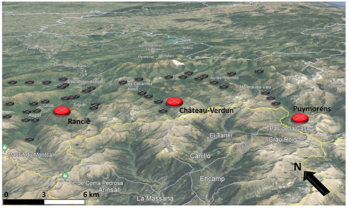
Figure 1. Location of the mines of Puymorens and Rancié in the Pyrenees Mountains. Forges and ≪ moulines ≫ (gray dots) are found in all the valleys nearby these mines (red dots). Borders of Ariège & Pyrénées-Orientales Departments are in pale blue and international border with Andorra is in yellow. Adapted from Balent (2005) and Poujade (2008).
The Rancié iron mine is known as 'the mine of the miners' and is famous for its 'collective' status, which has taken on the valance of myth. Here, we quote Garmy (1963): “The iron mine of Rancié was, for centuries, the collective and undivided property of the inhabitants of the upper Pyrenean valley of Vicdessos, encompassing eight communes including Sem, Goulier and Olbier, the closest to the site.” The first written documents concerning the institution are charters granted by the County of Foix in 1272, 1293 and 1332. They consist of a set of franchises, uses and customs recognizing ancient rights “in return for a fee”. These texts are therefore similar to other communal emancipation charters and apply, theoretically without distinction, to all the inhabitants of the valley (Blanks, 1998; Denjean, 2003). It was then an entirely local industry, and the exploited ore was directly processed by the local forge masters of Vicdessos themselves. These local notables were also consuls, or community leaders, and took advantage of this to impose their prices on miners (Rouzaud, 1908; Galabert, 1909), thanks to their coulias or handymen and storekeepers. In fact, the mine was in the hands of a patriciate formed by rich families who, in addition to being consuls, admittedly elected but by evergetism, monopolized access to the ore, local transformation into iron, and the best land and notary offices. The opening of the Rancié iron trade in 1355 with “foreigners” outside of the Vicdessos, which was considered to be of good quality (François, 1843), was borne out of an obligation to obtain wood for the forges and the exploitation of the ore itself, as the forests of the Vicdessos had largely been destroyed (Petrowiste, 2003, 2010; Poujade, 2008). This opening created a chaotic situation of exploitation and transactions that pitted miners, ore buyers and consuls against each other. In 1414, the Count of Foix took control back, setting up a regulation applied by a group of jurats or overseers, managing the mine, fixing prices but with the right of pre-emption for local consuls (Rouzaud, 1908) and introducing a first tax for the benefit of the county.
This formal situation was maintained until the beginning of the 18th century with the abolition of the consuls' elections in favor of a political council composed of the great families who chose the consuls of the valley instead. The Regulation of 1731 was a form of passing the torch of authority from the county of Foix to the Kingdom of France, which reaffirmed the jurats' legitimacy to police the area, on mining practices and iron sales but also mining rights and maintenance obligations for the mine (which often collapsed) and the pre-emption of new seams by miners, as well as the local consuls on the ore to be sold. The system functioned in this way until the Revolution reaffirmed the preeminence of the locals over foreigners, of the consuls over the miners and of the miners over the carriers (Rouzaud, 1908; Garmy, 1963).
The Revolution, as it led to the abolition of privileges, implies in this case the abolition of formal local leaders. The arrival of the Consulate and then the Napoleonic Empire, eager for iron for cannons, led to a gradual takeover by the imperial prefects through new statutes, new taxes, the coming of an engineer mandated to manage the mine, and the support of the prefect.6 Organizational practices of exploitation did not change: 250 to 300 miners worked in teams, each one taking care of only its own vein to exploit it as quickly as possible and to the detriment of safety. The engineer found it difficult to organize collective work beyond the team level, as each local group had no interest in it.7 Revolts8 did not truly change the situation. Moreover, the mining rights each inhabitant had over the mine were questioned by successive mining regulations (1805, 1816, 1821, 1826, 1833). The concession was formally handed over to the mayors of the valley (mostly former consuls) by the creation of the Société des Maîtres de Forges de l'Ariège in 1833, but all the management was carried out by the prefect and managed by the engineer, who defined the labor allocations (Garmy, 1963). With the tripling of the number of forges in the region, iron was in high demand, and Rancié entered the Industrial Revolution by increasing its production sixfold between 1811 and 1841, “firstly through incessant control and effective and serious management” (Feraud-Girault, 1887 quoted by Garmy, 1963).
Competition between the different actors had therefore never made the miners the beneficiaries of the mine and had kept the mine in a state of technical backwardness and structural danger9 (Reulle, 1962; Caster, 1963; Gaillard, 1971). The acceleration of railway growth, then sea transport and finally colonization put this mine in competition with cheaper iron ore from Roussillon, then Lorraine and finally Mauritania. The last gallery was drilled at the end of the 19th century, and the mine was definitively abandoned in 1929 following a new collapse that killed two people. Safety improvements required work to shore up the support pillars, which made it unprofitable for the company that had become Société Métallurgique de l'Ariège (SMA), which by then preferred Puymorens.
The Puymorens iron mine (or Pimorent in Catalan, also accepted in Pyrénées-Orientales) is located in the present-day commune of Porté-Puymorens. The corresponding valley of Querol (or formerly Carol), dating from a passage of Charlemagne (Carolus Magnus), had seen its limits defined and a right to a mining activity recognized by various acts in the 13th century (1294, 1295, 1297) by the county of Cerdanya, thus demarcating it from its neighbors of the time10. The Royal Prosecutor of the Kingdom of Spain granted a right of exploitation in 1623 to Mr. Pal of Andorra for 1 year and then again in 1624 to Pere Costa, surgeon and representative of a family of notables of Cerdanya, who undertook work on shallow outcrops. Indeed, the mine is located near the Roussillon passes, including Puymorens, and can easily supply the Catalan forges, which were then in full development (Jorré, 1938, pp. 85–88; Poujade, 2008). The Barutells, lords of Oix, Talaixà and Bestrecà (Upper Garrotxe), and Puig Barutell (Empordà) had forges in the Vallespir valley and were interested in this iron, which they got through an ad hoc marriage with the daughter of Pere Costa. After 20 years of Franco-Spanish warfare, during which the Querol miners took over the exploitation of the mine, the 1659 Treaty of the Pyrenees brought it under French jurisdiction, and it took 14 years for the Barutells to have their hold on the mine reconfirmed by the French authorities. A new marriage in 1747 brought it under the ownership of a family from Barcelona, headed by the Marquis de Sanz. The French Revolution brought about the eclipse of Sanz, who in theory was still concessionaire. The ore was exploited by the Querol inhabitants for their exclusive benefit from 1790, when Querol became a commune under French common law, until 1843 when a royal decree ended a very long legal battle. After two very conflicting partitions (1838 and 1861) between the communes thus created, the mine location was then assigned to the commune of Porté (Balent, 2005, 2018).
The appearance of the English blast furnace method, with the first in the department at Tarascon in 1868, led to the obsolescence of the classic Catalan forge, which had been growing rapidly until then (Jorré, 1938). The Sanz family began to lease the mine from 1869 to the same SMA that managed Rancié, which already owned a blast furnace and had begun to extract ore from an adjacent mine. The company set up joint facilities that brought the ore downhill by a convoy of wagons. From 1884, during the Great Depression (1874–1895), the SMA experienced economic difficulties. However, this did not prevent the SMA from definitively buying the mine from the Sanz family in 1918, following the Great War, which was a major consumer of iron, after years of legal battles (between the Sanz family, the SMA and the municipalities of the Querol valley) during which work was halted. Until the demarcation of 1930, the local communes sued each other to delimit their boundaries in the context of conflicts between the Catalans and Ariegeois, who both claimed that these lands were located in the upper Ariege. The 1929 crisis led to the 1930–1931 takeover of the SMA mine concession by the SFD (Société de Roquelaure et de Fumel). The SFD invested in the capacity for wintertime extraction and transfer to the recently built Trans Pyrenees railway (Bouneau, 2015): electric cable replaced the trolleys between the mine and the Hospitalet railway station, leading to the installation of electricity in the newly constructed mining colony (Balent, 2005, 2018).
The German occupation led to a command economy; in 1941, the SFD was absorbed by a subsidiary of the Forges & Aciéries de Pont-à-Mousson but was still subject to the Pyrénées-Orientales departmental section of the iron mining public management service, located first in Perpignan and then in Vernet (Conflent). After Liberation, mining continued without any new investment, and after a long history of successive staff reductions, it formally stopped in 1960, as did almost all the mines in Roussillon and Catalonia (with few attempts to resume mining till 1962), who were under competition with iron from Lorraine and Mauritania. The final stop was pronounced on May 1966, and exactly 1 year later, the municipal council of Porté closed its mining lease, reducing the village population from 185 inhabitants in 1962 to 108 inhabitants in 1967 (Balent, 2005).
A few feeble heritage preservation attempts have been made since then (Figure 2), through the creation of dedicated sites and in connection with the tourism expansion related to the development of the Puymorens ski resort since its opening in 1936 (Piguillem, 2011; Cantelaube, 2020). Since then, it has been abandoned as an arrival point for day hikers.
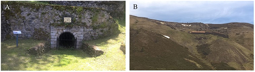
Figure 2. (A) Visible remains of one entrance of the Rancié mine (Gallery called Becquey). (B) Upper mountain Puymorens mine facilities dominating the Porté Pass (France) (Photographs authors).
Thus, these two mines have been the object of systematic conflicts between the same three actors: local peasant miners and their representatives, wealthy families and various states. Their histories must be understood as the product of mountain particularities, where accessibility but also oppositions between valleys are important (Morère, 1913; Fornier, 1969; Guillot, 2009, 2011). Ultimately, local conflicts were no match for the structural tripartite opposition (Chevalier, 1837, 1954; Cavaillès, 1912). There were moments of violent instability, usually linked to national-level uprisings, interspersed with periods of stability, often achieved by force. The gradual appropriation by regional families (the consuls at Rancié, the aristocrats at Puymorens, of increasingly distant origins) was thanks to the support of the ruling state, which favored stability to the detriment of the miners. Miners took advantage of the slightest loopholes (revolutions, wars) to try to eventually (re)appropriate rights, but without achieving any notable victories.
Tunisia: Mornag Plain and Jebel Ressass: Ebb and flow of a colonization
Mining activity in Tunisia dates to Roman and Carthaginian times (Sainfeld, 1952). The 19th century onwards, and especially the colonial period, saw this activity reaching its peak with various ores11 and energy sources12 (Boussen, 2010). The remnants on Tunisian mountains are still very visible (Figure 3), but the social, health and land tenure consequences remain very little studied (Saadaoui, 2017; Sioud and Rejeb, 2017), particularly the relationship between mines and sociospatial dynamics. Indeed, since Tunisian independence, the Tunisian mountains have almost exclusively been the subject of biogeography or human geography works and little analysis in social geography. Spatial and sectoral visions are favored, which focus on economic and land production assets. Few studies mention the multifunctional nature of mountain land uses, inducing land use conflicts (Sioud and Rejeb, 2017). The Jebel Ressass dominating the Mornag Plain (735 m) should be considered a quasi-periurban area on the periphery of the Greater Tunis metropolis (Figures 3, 4). This positioning leads to very specific, complex and, above all, rapidly evolving issues, such as the construction of a large cement factory, the evolution of agrarian occupations from marginalized rural peasants to agro-industrial intensification, etc. This agricultural plain of Mornag is one of the richest in Tunisia13. It is favored by its hydrological network structured around the Miliane wadi14 and the corresponding aquifer, which is the only one existing in the Ben Arous region.
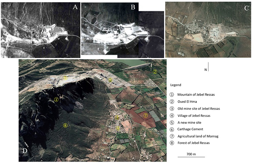
Figure 3. (A) The mining site of Jebel Ressas in 1947. (B) 1963 with the first miners' houses (Aerial Photographs). (C) 2004 (Google Earth) with a dispersed habitat. (D) The mining site and the village of Jebel Ressas with a urbanization around the quarry/cement factory facility of the Cement Carthage company in 2021 (Google Earth).
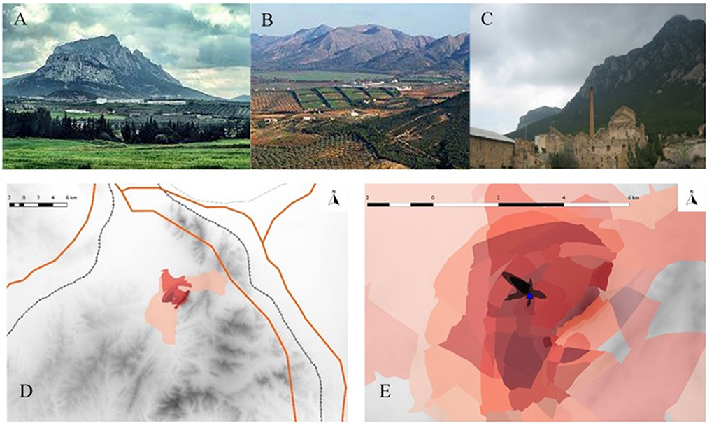
Figure 4. (A) The Jebel Ressass dominating the Mornag Plain. (B) The plain itself seen from the Mont. (C) The remains of the mine (Photographs authors). (D) The Zone contaminated by aerial dispersion of the mine halves according to the aerial dispersion model of Ghorbel et al. (2010). (E) according to the local perception as assessed by Perception-Based Regional Mapping (Saqalli et al., 2020).
Before French colonization, Beylical Tunisia was subdivided into 70 caïdats with an essentially fiscal function, with each caïdat corresponding to a tribal territory. The basic unit was the Macheikhat, headed by a Sheikh who assisted the Caïd in the collection of taxes and directed douars, a group of dwellings or villages (Belhedi, 1989). The French Protectorate of Tunisia, established in 1881, reduced the number of caïdats to 36 and set up communes in places where there were large numbers of European settlers, i.e., where there were significant agricultural and mining resources (Bourdet, 1952; Dupont, 1952; Salhi, 2017). The colonial powers seized a quasi-monopoly on the exploitation of the country's mineral resources under the guise of various nominees and, in particular, Beylical government members (Bourdet, 1952; Dupont, 1952). Independence in 1956 saw the preservation of the Macheikhat until 1969, when the territory was subdivided into governorates, communes and “sectors” or Imada, whose head was the Omda. In 1989, the governorates were endowed with a regional council composed of locally elected officials (Allal, 2010) and responsible for, among other things, regional development plans to better join local stakeholders (municipalities, MPs, etc.) (Belhedi, 2015). Interestingly, mining is the sole activity regulated by itself. The government and private mining companies operate through the Mining Code, which does not consider any participation or consultation of local communities in mining management.
The Jebel Ressass lead (Pb) and zinc (Zn) mining site is located approximately 30 km southeast of the city of Tunis. A first concession was granted in 1877 by the Bey to the Sociétà Metallurgica Italiana, which abandoned its important investments in 1892. It was in 1900 that Cambefort, a banker from Lyon and “forge master”15 (then St-Gobain), Jacquemont and Wilmotte, all of whom already owned several mines, launched the Société des Mines du Djebel Ressass, with headquarters in Paris. Production began immediately and was encouraged by favorable prices (Léger, 2021). Following the example of the Gafsa mining basin, after expropriation of the land, the Compagnie minière built the processing facilities, offices and the mining village close to the production sites, recruiting workers from all over Tunisia, preferably with no local family or tribal ties (Salhi, 2017). A specific form of organization was set up for supervisory purposes wherein the Company was represented by a native “village chief,” a deputy, the Mokhazni, and a sheikh who represented the power of the Caïd. The choice to build housing and basic infrastructure created an interdependence between the mining company and the local inhabitants. It also shaped the organization and morphology of the space according to ethnic marking, which is typical of the logic of colonial mining towns in the Maghreb, i.e., a well-defined architectural style (Figure 4C) composed of the “Douar,” which is reserved for Arabs, and the “Village,” which is reserved for Europeans (Saadaoui, 2017). Meanwhile, the Mornag Plain was entirely appropriated by French settlers16. With no villages or indigenous hamlets, the plain was planted with vines and olive trees and supported by a few estates of settlers that were far from each other.
Production reached 15,000 t of ore in 1904 with an estimated reserve of 432,000 t, i.e., 29 years at that rate of extraction, re-evaluated to 7 years in 1907. Prices fell from this date onwards, as the Tunisian government applied new social rules while the low volume of proven and exploitable reserves was confirmed. Being part of an assumed mining lobby17 working actively in the French National Assembly, Jebel Ressass escaped certain tax decrees but did not escape a tax adjustment in 1910 and then the consequences of the cholera epidemic of 1911 on manpower. Mining went from open-cast to underground; new galleries were dug, allowing a stabilization and then a strong increase in profits, including and thanks to the First World War, which broke out in 1914. The end of the war brought production down to 5,000 tons per year, and the company, which was now incurring losses, stopped mining in 1927. It was transferred to the Société Minière et Métallurgique of Peñarroya in 1928, and it resumed its activity with difficulty in 1938, only to stop during the Second World War. It closed for good in 1951. Since then, at the western foot of the massif, the mine and the processing site, consisting of three waste heaps (DI, DII, DIII), have been abandoned. Adjacent to the DIII dump is the village of Jebel Ressass. Part of the European mining village has been taken over by the families of former miners, and the other part is in ruins. The “Arab” village has expanded, and a football field installed on the heaps. The mountain bears the traces of this exploitation (Boussen, 2010; Ghorbel et al., 2010). Erosion of these heaps, especially by wind, is most likely a source of lead pollution throughout the region [Figure 4D according to a wind model from Ghorbel et al. (2010) and Figure 4E according to local perceptions from Saqalli et al. (2020)].
The mining and industrial history of Jebel Ressass does not end there. As a result of the split of the company “Les Grandes Carrières du Nord,” the company “Cement Carthage” settled in 2008 on the southwestern slope of the mountain, operating a limestone quarry and the largest cement factory in Africa. The site covers 218 ha and employs 774 direct employees. The combined dust produced from both mining activities is now seen, along with household waste, as the largest environmental nuisance within a 20 km radius, to which must be added the cracks caused by regular blasting of the mountain (Saqalli et al., 2020).
At the western edge of the spoil heaps, agricultural activity has developed on the plain up to the Wadi Hma (Figures 4A,B). The former domains of Mornag have been appropriated by the workers or settler-sharecroppers, constituting small rural nuclei. The downstream part of the Miliane Wadi has benefited from agricultural development actions raised in the 1980s based on “optimizing the exploitation of natural resources and intensifying cultivation” (Attia, 2015), in particular by mobilizing “northern” water18 and developing intensive irrigated areas (Horchani, 2007).
From then on, the Mornag Plain was stratified into several areas that included a portion north of the southwest-northeast axis perpendicular to the Tunis-Grombalia highway19 that benefited from irrigation and very intensive olive tree plantations that were managed all over the area (321,000 plants) on semiprivate Habous land20, which was fairly fragmented and exploited by small farmers (Mouri, 2012; Hamrita et al., 2017). In addition, fruit trees and market gardening have been introduced as a result of state incentives. The central part was cultivated with cereal grains and vines by large landowners with 56,000 ha in 1993. The southern zone, which is hilly and of little interest to settlers, has retained its rural organization of Douars with mixed farming and livestock cultivation (Saqalli et al., 2020) 21.
Finally, the urban expansion of Tunis is a specific factor of this mining site. It has led to a number of dysfunctions that have not been sufficiently corrected by the State22 and have accelerated with the rural exodus (Hamrita et al., 2021). The Mornag Plain is strongly affected by this periurbanization (1,679 additional inhabitants for Mornag alone in 2004). Indeed, several migration types affect the territory in addition to local demographic growth, including the migration of middle- and working-class households to access property as well as purchases of second homes and agricultural plots by an urban bourgeoisie, as in all neighboring agricultural plains (Hammami et al., 2010). This urbanization has gone beyond the original metropolitan area to encompass the area described as a metropolitan solidarity zone, in other words, a spillway (Dlala, 2011; Hammami et al., 2019).
Moreover, the nibbling away of agricultural land, threatening the irrigated perimeters, has continued since the 1970s, particularly around Cébalat Mornag (Dlala, 2011)23, in part by residential housing in the commune and industrial installations along the roads but also paradoxically by public housing operations such as the SNIT (Chaline, 1990)24. This recently developed periurban area forms a “line of conflict” with the rural neighborhood (Dlala, 2011). More broadly, this urban sprawl has led to a disruption of the unity of the predominantly rural landscape and has become an important issue for the Mornag Plain (Boussetta et al., 2015, 2018; Saqalli et al., 2020).
However, the combination of the natural site, the vineyards of Mornag and the ruined mining site constitute real heritage potential. Vineyards and agriculture provide the Greater Tunis Metropolis with local products considered to be of high quality, and these landscapes are recognized as attractive for alternative local tourism. Landscapes and local products could provide a singular and significant imprint of the territory (Olmo et al., 2012) and a geographical label for tourist and landscape valorisation. Indeed, different public initiatives25 and a participatory inventory of heritage landscapes26 (Hamrita et al., 2021) contribute to enabling these landscapes to feed and network some local actors (farmers, residents, associations, real estate developers, etc.) around this heritage.
Morocco: The Upper Moulouya: The story of an appropriation
Because of its history and the interweaving of local histories, Morocco has a complex land situation throughout its territory (Raynal, 1952). Land tenure types are diverse. First, for example, there is both a public domain and a private domain of state-managed royal palaces, national parks and public forests. Furthermore, several private statuses are linked to the mode of appropriation and management of the mode of inheritance. Private property status uses the Muslim law of the uncodified Melkite rite (Zirafi-Devif, 2011). It coexists with the private status registered in the land code and in the Habous land. In collective terms, two statuses coexist: collective tribal lands (Soullalies) which constitute the vast majority of Moroccan territory outside the outskirts of cities (Bouderbala, 1996) and are managed by the orf , or the customary law (Lahsen, 1986). Finally, from the 16th century onwards, several sultans secured the loyalty and military obligations of certain tribes by granting them lands called Guich, which are now seen as another state domain type (Zirafi-Devif, 2011)27. The right of public appropriation of collective lands, historically dedicated to agriculture and grazing, was indeed recognized during this colonial period. It allowed for the massive expansion of private property, first for the benefit of urban dwellers in large cities, including, above all, Fez, the then-capital of Morocco (Lahsen, 1986; Bouderbala, 1999), but second for large mining companies (Zirafi-Devif, 2011; Balgley and Rignall, 2021).
At the junction of the Middle and High Atlas, the Upper Moulouya River valley is an ancient place of human occupation. Lahsen (1986) quotes: “The space [...] functioned [...] in a continuous movement of populations and herds between the mountain and its edges, the former serving as summer pastures, the latter (the azarhar) as winter pastures. The immediate or distant borders of the Middle Atlas were thus considered an integral part of the living space of the seminomadic tribes. Village peasantry have long occupied the foothills and valleys of the mountains, where they have formed nuclei of sedentarisation and developed small, irrigated areas28”. This network of villages, Zaouïas, Berber or Makhzen-originated qasbas29, and ancient urban centers gave the Middle Atlas the appearance of a relatively populated area, in contrast with the rest of the territory. However, each of these tribes saw their crops confined to the steppe plains on the banks of perennial watercourses30. Thus, the crops that were necessarily irrigated were privately owned, whereas the rangelands were collective. The latter have highly variable management methods, and their rules are subject to many different interpretations from one end of the Upper Moulouya basin to the other. The mountains (Middle Atlas and Boumia Ridge) offer better grazing lands and the possibility of dry farming (Guennoun, 2000) (Figures 5A,B).
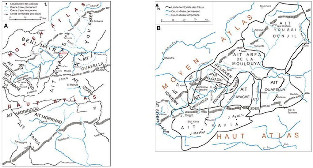
Figure 5. (A) Human groups on the Upper Moulouya at the beginning of the 19th century (adapted from B.E.S.M, 1956 by authors). (B) Geographic location of the tribes living in the Upper Moulouya in 1950 (adapted from B.E.S.M, 1956 by authors).
This relative prosperity only made sense if this distribution of territory between tribes was stable without too many conflicts. However, the 19th and early 20th centuries saw large migrations, mostly from the South, such as the Sanhaja and the Zemmour (Lesne, 1967; Lévy, 1996; Maurer, 1996), who came to settle in the plains of the Upper Moulouya because of the available water and rangelands but also because of its strategic location between the Atlas mountains, the high plateaus, the pre-Saharan oases and the hamadas of the South, which were linked by imperial roads (Célerier, 1937) (Figure 5. Transition from situation Figure 5A to Figure 5B). This instability disrupted the status and possessions of each tribe and weakened the kingdom.
The establishment of the French protectorate in 191231 led to a violent military “pacification” that took 5–10 years to reach the Haute Moulouya (Service Géographique du Maroc, 1928). It should be noted that the treaties of Algeciras and Fez establishing the protectorate included from the outset the establishment of an authority dedicated to mining conflicts, showing the strategic interest in this activity. Thirty good mining companies were already active in preparing for this colonization32. However, if in 1927 there were 3,177 research and prospecting permits, only 7 exploitation permits had been requested, valid as a concession. Following the example of the BRGM33 in France, the French Residence in Morocco created the BRPM34 to manage this craze. Prospecting for the lead-bearing Upper Moulouya galena vein was launched in 1925 by the Compagnie Royale Asturienne des Mines at Mibladen. The Paris-based Compagnie Minière de l'Afrique du Nord, via its two subsidiaries, Société des mines d'Ahouli and Société Marocaine des mines de l'Outat, each named after two prospecting sites in the same region (Figure 6), began prospecting in 1929. The local headquarters were located first in Midelt, then Casablanca and then Rabat, but their funding remained French and Belgian. The land exploited by the mining companies was the property of the tribal confederations of Aït Izdeg, Aït Ouafella, Aït Moulli and Aït Ayache (Figure 5B). Agreements were made between the latter through their representatives and the mining companies under the aegis of the Moroccan state and the French Protectorate (Bourdet, 1952; Dupont, 1952). From then on, the region experienced a great development of infrastructure (roads and electrification stations, then railways in 1927), first linked to its great mining potential and in particular its lead deposits35. Midelt, the main town of the Upper Moulouya, became a real European town and even, later on, a military garrison and a regional economic center, entirely driven by these mines.
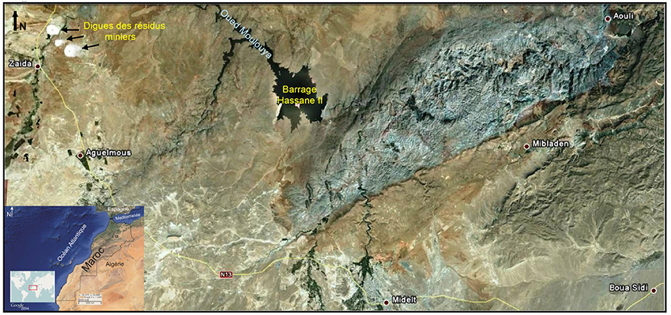
Figure 6. The Mining district of Zeïda-Mibladen-Ahouli (image Google Earth, 2020).
1931 saw mining prices become entangled with the economic crisis and fall by 50%, and these mines were closed until the 1936 French Franc devaluation, although investments continued. From then on, the two mines of Mibladen and Ahouli were in full expansion36. The large company Peñarroya gradually took control of first one and then both mines in 1946, allowing a resumption of exploitation and strong investments at the end of the Second World War. These three mines attracted a workforce from all over Morocco of up to 40,000 people (Bourdet, 1952; Dupont, 1952; Léger, 2017). They were driven by, among other factors, the gradual decrease in the relative value of pastoral products but also by droughts, particularly that of 1945 (Raynal, 1951), and the reduction of esparto pasture land by the mining concessions themselves (approximately 1,000 km2 all together), so that many transhumant people were converted into mine workers. The transient state of land occupation thus became permanent and perennial.
The BRPM prospected the development of a new site in 1958. The Zeïda mine, a joint venture between the BRPM and the Zellidja company, opened in 1966 and began to exploit ore deposits in 197237 (Elazhari, 2013). The exploitation of these three mines lasted until 1985, when the counter-shock in commodity prices brought the profitability of mining to a halt.
Much of the collective land, particularly that which could be cultivated in the dry season, was then put under cultivation, either by local families or by urban dwellers (Lahsen, 1986; Bouderbala, 1999), such as the privately irrigated Melk properties. Allocation was certainly by right of clearing or other historical rights for a fixed period of time, but above all required means38 that reinforced increasing social stratification (Bouderbala, 1999). The delimitation of non-private land between tribes was only established after 1949, which was late in comparison with other areas of Morocco. These census operations led to great inequalities between and within tribes which are still unresolved (Raynal, 1952, 1960).
Since 1985, the Upper Moulouya area has seen its development come to a halt. A few proposals for heritage development have been put forward but have not met with any interest (Abdelghani and Oumhani, 2013), focusing on the development of industrial heritage but also of the mining towns. The working-class town of Engil above Ahouli, for example, is made up of a hundred or so semidetached houses, each of less than 20 m2, with their rooves and furniture removed (Michard, 2011). Mibladen continues to be mined artisanally with several hundred miners on a permanent basis (Bailleul, 2015), as does Ahouli via the SIF gallery for vanadinite mining (Michard, 2011). The abandonment of mines without rehabilitation after the cessation of exploitation continues to generate significant environmental impacts (the contamination of the territory and people, destruction of landscapes, and clear-cutting of the surrounding forests) (El Hachimi et al., 2005, 2013, 2014; Chahboune et al., 2019; Nassiri et al., 2021).
Discussion: The mine as a focal point of appetite and tension
What do we learn from these three mining stories about three different Mediterranean countries, which are historically subject to the same French law and similar private interests? What emerges first is the extraordinary similarity of the stories of these three places. All three were occupied for millennia and used for agricultural and pastoral purposes. In no case were they naturally French, but rather they were all the object of conquest. The assertion of a power with the means to impose its law, unlike previous powers (royal France in the 18th century, protectorates in the early 20th century against the county of Foix, the kingdom of Aragon, the Tunisian beylicate and the Moroccan Sultanate), explains the takeover, mostly by force, of the territory. Private interests were formed, led by an entrepreneur or creator of a family company: Ledoux and Rothschild for Peñarroya and therefore Mibladen, Zeïda, Cambefort, and then Jacquemont for Jebel Ressass (Sermet, 1964; Troly, 2008; Léger, 2021), Costa, Barrutel then Sanz for Puymorens, and the consuls for Rancié. They were appropriated and/or organized into locked joint stock companies (Société des Maîtres de Forges de l'Ariège, Forges et Aciéries de Pont-à-Mousson, Asturienne des Mines, Minière de l'Afrique du Nord, SODIM then Zellidja, Société des Mines du Djebel-Ressass, Peñarroya, etc.), all of which were to remain in existence despite historical vicissitudes, but were also to suffer from a fall in the price of lead, zinc, iron and silver, to undergo a succession of takeovers, restructurings, and changes of name and finally to disappear.
In all three cases, this history was made with the support of the French state, including the military. Admittedly, this link between the establishment of the French state in the territory and the mine39 is not always direct, but this establishment is directly linked to the idea of transforming the territory and the people; the mystique of making Berbers into new Frenchmen (Ageron, 1971) was contemporary with making the Pyreneans modern people. Law and order enforcement interventions were numerous, repeated for the Pyrenees, devastating for the Moroccan Middle Atlas, and controlled for Tunisia.
Above all, the benefits of the exploitation never remained locally, and the extent of the infrastructure built remained, if not limited, at least restricted to improvements of the mining exploitation process (railroads in Pyrenees, roads in the Middle Atlas). Only the Jebel Ressass has seen a development of infrastructure, but this is likely because it is very close to the main axis of the country. There has never been a formal financial component dedicating a share of the mining profits to local development.
Conversely, the tailings and, in particular, the colossal lead-bearing heaps of Zeïda and Jebel Ressass are still very much present (Balent, 2005; Ghorbel et al., 2010; Bounakhla et al., 2012; Iavazzo et al., 2012; El Hachimi et al., 2013; Brahmi et al., 2014; Mezned et al., 2016; Disser and Dubois, 2019; Saqalli et al., 2020; Forget and Rossi, 2021). No plan or compensation has been envisaged for the rehabilitation of these territories (El Hachimi et al., 2005), and the successive changes in the name or corporate name of the mining companies concerned have reduced the legal, health and environmental responsibilities of the rightful owners and heirs of these mining companies (Troly, 2008; Forget and Rossi, 2021). Attempts at heritage enhancement are hampered by the lack of national or regional will, the limited funding for enhancement and the lack of appeal given the small number of national or international tourists who might be interested in visiting this heritage site, but they are hampered above all by poor geographic accessibility and the low number of tourists. Only the site of Jebel Ressass, on the immediate edge of the large city of Tunis and so easily accessible, can constitute a heritage site with large potential (Boussetta et al., 2018) (Table 1).
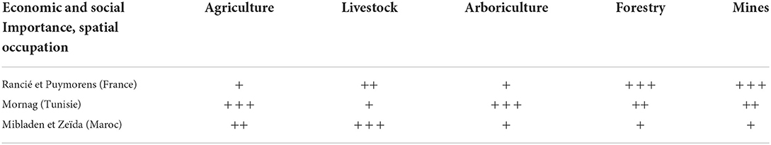
Table 1. Brief relative comparison between the three sites' activities and assets.
The establishment of mines reflects the interpenetration of rights over the soil and subsoil; we have seen that territorial appropriation by private companies must necessarily be preceded by a modification of the local law allowing this appropriation. It is true that the sites concerned were not always sufficiently strategic to induce ad hoc modifications specifically dedicated to the legitimization of their exploitation, as has been seen for other extractive activities such as oil. However, these legal changes did take place, replacing local law with the implementation of a mining code and an enhancement of private law. Similarly, it would be interesting to examine the legal procedures that have led to the removal of responsibility for health and the environment from the companies concerned. Thus, if the outside observer cannot have access to all the local dynamics and especially the steps taken by industrial actors to set up or withdraw, the observation of decrees, laws and local decisions would be a useful lead.
The mine is thus a “canary,” an early indicator of the political power relations among local actors as well as between those actors and the outside world. As they are often the most lucrative point per spatial unit in mountain territories, the mines reflect these power relations through the modes of appropriation in the place of greatest tension. Thus, while the internal relations at the Rancié mine were to the advantage of the consuls, they were able to keep the external actors at a distance for a very long time. The arrival of the French state, the imposition of a national law and competition through improved communications reduced their local powers. Conversely, Tunisian independence underlined the fact that the most lucrative activity of the moment was land, given the tensions over the appropriation of colonial exploitations and the lack of interest in the Jebel Ressass mine. Finally, the failures of the attempts to demand site rehabilitation, compensation through investment or compensation from local actors around the mines of Zeïda and Mibladen suggest power relations that are not very advantageous to these local actors. It is thus an indicator of the power relations between actors during the post-mining period. It allows for a diagnosis of the power relations and integration of marginal rural areas within the nation concerned, and in particular in the reluctance of the nation-state to confront either the direct management of waste and post-mining pollution or enforcement of environmental policies on the companies that inherited the mining titles.
It finally plays a canary's role for the past. One may have noticed the difficulty in obtaining archives and quantified data on populations and territories in areas that have been surveyed only slightly or not at all. However, the mines encourage archiving, and the data on the Vicdessos valley are thus better than for the adjoining valleys for the periods before the 19th century. They are therefore an opportunity to obtain better data on one territory's past simply because of a greater density of experts and therefore of various reports (military, administrators, engineers, etc.) carried out on the territory concerned.
Thanks to all those elements, we here plea for the integration of this nexus of political tensions, financial capital and human powers that are mines into the common protocol of investigations regarding rural landscapes and territories. Indeed, practically, the appropriation and control by external powers such as imperial/colonizing/central governments of a remote place such as mountains were and still are considered only a consequence of the first target, namely, the exploitation of mines and other fruitful points. As a result, we submit the following research proposal combining both anthropological, human geographical and environmental investigations:
- Investigating the financial and juridical documents describing and/or having settled the differential access of local stakeholders and actors to the various natural resources, from mine ores to pastures and farmlands, to determine the past, present, and eventually future legal stakes and perspectives;
- Interviewing the last witnesses of this mining transition from production to postproduction and their direct descendants closure of Rancié in 1929, Puymorens in 1966, Jebel Ressass in 1957, Mibladen & Zeïda in 1985 to reconstitute the various ways of living in different eras;
- Using Perception-Based Regional Mapping (Saqalli et al., 2009) to spatially locate the territorial hold of each of these spheres, visible through land uses and rights, waste zones, political distributions, accessibility to public infrastructure and facilities and the hybridization spaces between these cultural and legal spheres;
- Assessing a rural and agrarian diagnosis for defining present-time activities and constraints, thanks to which economic prospectives could be assessed.
Conclusion
Thus, we have seen the interplay between the history of a territory, land tenure systems and public and private modes of appropriation in three different areas and three different countries, which were also historically subject to the same imperium over time. This interplay produces extremely similar modes of appropriation, use and policy during the acquisition, exploitation and post-exploitation phases. The latter period is now between 93 years for Rancié and 37 years for Zeïda. None of these mines have been rehabilitated. Some other examples, such as the Salsigne mine, show that rehabilitation remains partial and that deleterious environmental and health effects persist (Dondon et al., 2005; Delplace et al., 2022). Despite the passage of time and the implementation of environmental laws in all three countries and even lengthy legal proceedings, the fact that environmental and health consequences are now documented and sometimes acknowledged by local or national authorities did not change the attitude of governments.
Indeed, the history of the mines in French Ariège differs little from the mines in Moroccan or Tunisian protectorates. The time difference is due first to the fact that the price of the exploited iron fell in metropolitan France earlier at the opening of the colony, whereas lead, zinc and possibly silver fell when these same protectorates faced free trade after the Second World War. The social conditions are remarkably similar, even if we note the stronger political presence of miners entitled to union membership because they were French citizens during the tensions and strikes that marked the end of the life of these mines. However, this did not make these facilities real miners' mines as the myth of Rancié would have us believe.
At all three sites, the cities were ultimately the main beneficiaries of these enterprises. However, while the management may have been run from local urban centers, it was the political and economic capital of the French empire in Paris that was the beneficiary:
- In France, it was first Vicdessos and Andorra, then Foix, Pont-à-Mousson and Barcelona, and finally the headquarters of all these companies were based in Paris;
- In Tunisia, the first Italian concession became French and managed from Tunis, only to see its titles managed from Paris;
- In Morocco, the appropriation of the territory through the development of the military post of Midelt was presented as a reconquest of the Fez-based Moroccan Makhzen, and the mining companies had their headquarters in Casablanca but were eventually managed from Paris.
The post-mining period left a legal, health and environmental vacuum. There is a striking contrast between the legal dotting of the changes to land ownership and the transmission of mining rights in the history of these three sites and the vagueness of the obligations and even the ownership of these sites today. Thus, the consequences of mining on a territory suggest a double Dutch disease (Davis and Tilton, 2005):
- During the period of exploitation, the territory creates a draft on labor and wages, and the opportunity for an alternative activity disappears instead of being stimulated, even with the building of new infrastructure and facilities;
- The post-operational period, with the environmental, legal and medical uncertainty it brings, paralyzes or at least reduces possible diversifications. The entrepreneurs, particularly real estate, land and property owners, of the Mornag plain on the edge of the Jebel Ressass will probably not support the development of this heritage, having to face rising land prices and health questionings;
- The Upper Moulouya, like the Vicdessos, has been emptied of its young population. Moreover, the appalling potential cost of rehabilitating these sites makes it difficult to make investments, particularly in tourism.
Thus, mining territories and populations are effectively the canaries of the relationships between actors in a territory, particularly between local and external actors. Eventually, they die.
Data availability statement
The raw data supporting the conclusions of this article will be made available by the authors, without undue reservation.
Ethics statement
Ethical review and approval was not required for the study on human participants in accordance with the local legislation and institutional requirements. Written informed consent for participation was not required for this study in accordance with the national legislation and the institutional requirements.
Author contributions
MS was in charge of the French section, the introduction and the conclusion as well as the final organization of the article. AH, HM, and HR were in charge of the Tunisian section. ML and EB were in charge of the Moroccan section. NR was the thematic reviewer. All authors contributed to the article and approved the submitted version.
Funding
This research have been supported by the FONCIMED network for transportation to the FONCIMED conference in Corte, France, and by SICMED and the ISA Chott-Meriem during the field actions in the Mornag Plain.
Conflict of interest
The authors declare that the research was conducted in the absence of any commercial or financial relationships that could be construed as a potential conflict of interest.
Publisher's note
All claims expressed in this article are solely those of the authors and do not necessarily represent those of their affiliated organizations, or those of the publisher, the editors and the reviewers. Any product that may be evaluated in this article, or claim that may be made by its manufacturer, is not guaranteed or endorsed by the publisher.
Footnotes
1. ^Agriculture is subsistence food first, except for niche crops (almonds, saffron, roses, apples, etc.). Livestock farming is local and then exported, with access to the mountain pastures negotiated among the transhumant herds. Wood is mainly exported to major consumption basins.
2. ^More capital and work must be brought in to develop a hectare of farmland, especially in the mountains, than a hectare of pastureland and even less a hectare of woodland.
3. ^From contamination of the land and people, destruction of the landscape, and clear-cutting of the surrounding forests.
4. ^In Morocco, 5 regimes have coexisted (4 at present), while three regimes remain in France (private, state-owned and communal-collective) and Tunisia, which passed from a Moroccan-equivalent system to a French-equivalent one (Martin, 2003, pp. 83-85).
5. ^The Mornag area, specifically the locality of Jebel Ressass, is emblematic of the inequality of access to land and the marginalization of the peasantry during colonial times (Hamrita et al., 2017; Gara et al., 2021).
6. ^The prefect did henceforth even define the price of the ore and quell any revolt with the gendarmerie and, if necessary, the army.
7. ^A school system was even rejected by the consuls, a system of carts was rejected by valets and storekeepers, and even the support pillars in the mine were dug by miners, etc.
8. ^the “War of the Maidens” in roughly 1830, a peasants' revolt to keep their rights to collective lands, pastures and forests taken over by local aristocracies; the 1848 “European Spring”.
9. ^e.g., not a week went by without deaths, at a rate 5 to 6 times worse than other French mines.
10. ^Andorra, Merenç, the Majorca kingdom & the county of Foix.
11. ^Lead, zinc, iron, phosphate, copper, silver, mercury, manganese, barite, fluorine, marble, etc.
12. ^Lignite, oil, etc.
13. ^36,812 hectares from which 19,900 of arable lands.
14. ^Numerous small wadis and tributaries: El Hammam wadi, Ben Aissa wadi, El Bakbak wadi, Skhira wadi, El Gsab wadi and El Boul wadi. These wadis flow between the Boukornine and Jebel Ressass mounts in the Mornag plain to flow into the Miliane wadi, until the Mediterranean Sea.
15. ^A French expression for wealthy aristocratic/industrial families having invested, managed and owned iron making and mining industries.
16. ^Resulting in severe inequalities: the average size of settlers' properties in Tunisia was 286 ha to 2 to 3 for native ones! (Sebag, 1951, p. 42).
17. ^The Chamber of Metal Mines.
18. ^The various dams and hillside reservoirs, the Mejerda- Cap-Bon canal crossing the Mornag plain.
19. ^Exploitation and intensification rates of the irrigated perimeters are approximately 100% for the private perimeters (1,570 ha) and nearly 75% for the public perimeters (5,378 ha).
20. ^The latter, called waqf in the Middle East, mainmorte in French, mortmain in English, is basically a legal act, most often put in writing in front of a cadi and several witnesses consisting of immobilizing property and allocating its income to specific beneficiaries. It was used extensively in Morocco and Tunisia to honor and maintain religious reliquaries containing the remains of holy men but also, when the beneficiaries are the family itself (family Habous or 'aïlî), as a way of maintaining a patrimony within the family without dispersion through female marriage out of the patriline (Tillon, 1966; Bleuchot, 1999).
21. ^As a result, the Mornag area includes 15,700 ha of forests and pastures and 1,230 ha of non-arable lands.
22. ^Habitat ≪ spontané ≫, dichotomie entre Sud de Tunis très industrialisé et Nord résidentiel, insuffisance des transports collectifs, des systèmes de collecte des ordures et des eaux usées, forte dégradation de l'environnement et en particulier des eaux.
23. ^111 ha have been urbanized in 16 years, between 2005 and 2021, because of strong urban expansion.
24. ^Société Nationale Immobilière de Tunisie = Public housing service of Tunisia.
25. ^Le vine festival, the Iter Vitis Magon Path.
26. ^Within the Iter Vitis Magon project (2014–2016) and grouping many stakeholders: the European Union, the cultural service association ANIMED, the Tunisia Tourism Office, the Tunisia Federation of Travel & Tourism Agencies, the Wine Producers' Chamber UTICA, the Association “Flavors of my Country,” etc.
27. ^This complexity was further compounded by multiple legacies, compromises and oppositions bequeathed to Morocco by the protectorate (Bouderbala, 1996; Gershovich, 2012; Rivet, 2012) and multiple successful divisions (division between the regions of Ifni and southern Morocco in 1884, the eastern region from 1901 to 1938, the French and Spanish protectorates in 1912, the international zone of Tangiers in 1923) (DGUA, 2002) or failed divisions that left their mark, such as the famous Berber dahir of 1930 (Ageron, 1971).
28. ^Saints or Zaouïas (mausoleum-monasteries) were often at the origin of these groupings. In addition, the piedmont saw the birth of a series of qasbas built by the Makhzen, particularly during the reign of Moulay Ismail (end of the 17th century) with a view to stopping the tribes' march toward the West and the North, i.e., toward the plains and to controlling the trade routes and the road linking the imperial capitals Fez and Marrakesh to each other, to the South toward the Tafilalet or to the East.
29. ^Makhzen: meaning the Imperial treasure and by metonymy, the Moroccan government. Qasbas (transl. In English by Kasbahs): fortified cities.
30. ^Moulouya Wadi, Oudrhès Wadi, Ansegmir Wadi, Outat Wadi (Figures 5, 6).
31. ^The protectorate is a status of colonial occupation and exploitation which differs from the colony, which has direct administration, by maintaining a national administration, protective military and police forces, and the obligation of infrastructure but reducing the possibility of settlers' colonization. Tunisia and Morocco are two French protectorates.
32. ^From 1912 to 1914, 42 French mining companies were created, and 52 exploration permits granted in Morocco, at a rate of 20 to 70 per month until the 1930s (Léger, 2017).
33. ^Bureau de Recherches Géologiques et Minières: https://www.brgm.fr.
34. ^Bureau minier chérifien de recherches et de participations minières.
35. ^The “Résident Général,” i.e., the French Governor of Morocco, declared in 1929: “it is the mining activity which has conditioned the railway and road policy, and the very evolution of all the national equipment for production”.
36. ^For example, for Mibladen 1,500 t in 1936, 3,750 t in 1937. For Ahouli, 4,500 t in 1936, 2,500 t in 1945, 27,000 t in 1954.
37. ^For Zeïda: between 38,160 t in 1975 and 49,773 t in 1980.
38. ^Especially livestock for farm work and enough grain for sowing.
39. ^With the explicit exception of the Moroccan case.
References
Abdelghani, B., and Oumhani, E. (2013). Le rôle du patrimoine dans le Développement des territoires en reconversion: Cas des anciennes mines d'Ahouli et Mibladen (Midelt – Maroc), Mons, Belgique: Association de Science Régionale de Langue Française.
Ageron, C. R. (1971). La politique berbère du protectorat marocain de 1913 a 1934. Rev. Hist. Mod. Contemp. 18, 50–90. doi: 10.3406/rhmc.1971.2135
Allal, A. (2010). Les configurations développementistes internationales au Maroc et en Tunisie: des policy tranfers à portée limitée. Crit. Int. 48, 97–116. doi: 10.3917/crii.048.0097
Attia, O. B. (2015). “Agriculture urbaine face à l'urbanisme non organise du périmètre public irrigué de Chott Mariem,” in Alternatives Éco Paysagères Dans les Régions Méditerranéennes, ed. H. Rejeb (Sousse: Ouvrage Interuniversitaire Transdisciplinaire à Comité de Lecture Internationale), 53–62.
Balan, H. (2021). Exploitation, post-mining, re-exploration? New projects for former French metal mines. Extr. Ind. Soc. 8, 104–110. doi: 10.1016/j.exis.2020.07.009
Balent, A. (2005). “La mine de fer de Puymorens (Cerdagne): conflits de propriété et d'usage (17ème-20ème siècles),” in Les ressources naturelles des Pyrénées du Moyen-Âge à l'époque moderne. Exploitation, gestion, appropriation, ed. A. Catafau (Perpinyà: Actes du congrès international Resopyr 1, Presses Universitaires de Perpignan), 423-451.
Balent, A. (2018). El mener i la mina del Pimorent. propietat, usdefruit, explotació. Una aproximació històrica (segles 17I i 19). Trobades Cult. Pirin. 14, 173–177. doi: 10.2436/15.8060.13.19
Balgley, D., and Rignall, K. (2021). “Land tenure in Morocco: colonial legacies, contemporary struggles,” in Land Tenure Challenges in Africa: Confronting the Land Governance Deficit, eds. H. Chitonge and R. Harvey (Cham: Springer International Publishing), 183–202. doi: 10.1007/978-3-030-82852-3_9
Belhedi, A. (2015). Repenser la fracture territoriale. Séminaire ≪ Sciences sociales en révolution. Tunis, Tunisie: Bibliothèque Nationale.
Blanks, D. R. (1998). “Mountain society: village and town in medieval Foix,” in Urban and Rural Communities in Medieval France. Provence and Languedoc, 1000-1500, eds. K. Reyerson and J. Drendel (Leiden: Brill), 163-192. doi: 10.1163/9789004474963_011
Bouderbala, N. (1996). Les terres collectives du Maroc dans la première période du protectorat (1912-1930). Rev. Mondes Musulmans Méditerr. 79, 143–156. doi: 10.3406/remmm.1996.1741
Bouderbala, N. (1999). “Les systèmes de propriété foncière au Maghreb. Le cas du Maroc,” in Politiques Foncières et Aménagement des Structures Agricoles Dans les Pays Méditerranéens: À La Mémoire de Pierre Coulomb, eds A. M. Jouve and N. Bouderbala (Montpellier: CIHEAM), 47–66.
Bounakhla, M., Embarch, K., Mounia, T., Baghdad, B., Naimi, M., Bouabdli, A., et al. (2012). PGAA metals analysis in tailings in Zaida abandoned mine, high Moulouya, Morocco. J. Radioanal. Nucl. Chem. 291, 129–135. doi: 10.1007/s10967-011-1321-6
Bouneau, C. (2015). Le rôle de la Compagnie des chemins de fer du Midi dans les trajectoires d'innovation des aires touristiques du Grand Sud-Ouest de 1852 - 1937. Sud-Ouest Européen. 39. doi: 10.4000/soe.1828
Boussen, S. (2010). Evolution de haldes plombo-zincifères dans le nord de la Tunisie: l'exemple d'un contexte carbonaté (Thèse de doctorat en Matériaux). Université de Limoges, France.
Boussetta, A., Saqalli, M., Maestripieri, N., and Rejeb, H. (2015). Comprendre un paysage et un territoire au travers d'un outil de spatialisation participatif: cas de la zone de Mornag-Jebel Ressas, in 11ème Spatial Analysis and Geomatics Conference (SAGEO 2015), ed. H. Baazaoui, C. Claramunt, M. R. Haddad, (Hammamet, Tunisia), 343–355.
Boussetta, A., Saqalli, M., and Rejeb, H. (2018). Diversité paysagère comme moyen de requalification de la plaine de Mornag, in Paysages Opérationnels en Faveur du Développement Territorial, Sousse, Tunisie: ISA Chott-Meriem, 38–45.
Brahmi, M., Zouari, S., and Rossi, M. (2014). L'industrie minière et ses effets écologiques. État socio-économique et environnemental dans le bassin minier tunisien. Collect. EDYTEM. Cah. Géogr. 17, 109–120. doi: 10.3406/edyte.2014.1279
Campmajo, P., Rendu, C., Crabol, D., Bousquet, D., and Luault, N. (2017). Les ressources minérales et végétales de la Cerdagne orientale. Bois, mines, fours à chaux, charbonnières et sites de transformation des minerais. L'apport de l'archéologie. Treb. Arqueol. 21, 65–76. doi: 10.5565/rev/tda.60
Cantelaube, J. (2020). “Minerai de fer, charbon de bois et métal: diversité et complexité des échanges de la sidérurgie ariégeoise dans les Pyrénées (XVIIe-XIXe siècle),” in Circulation des marchandises et réseaux commerciaux dans les Pyrénées (XIIIe-XIXe siècles), Minovez, ed J.-M. Poujade P. (Toulouse, France: Presses universitaires du Midi).
Caster, G. (1963). La vieille métallurgie ariégeoise: Reulle R., Mines de fer et métallurgie dans le Vicdessos: Rancié: un ≪ atelier national ≫ en Haute Ariège. Compte d'auteur, 1962. Ann. du Midi 75-62, 227–228.
Cavaillès, H. (1912). La région montagneuse du pays de Foix: Haute et Moyen Ariège. Ann. Géogr. 21, 118–129. doi: 10.3406/geo.1912.7191
Chahboune, M., Chahlaoui, A., Zaid, A., Mehanned, S., and Benmoussa, A. (2019). Impact du site minier abandonné de Zaida sur les eaux du barrage Hassan II (Maroc). Environnement, Risques and Santé 18 3, 261–267. Available online at: https://www.cairn.info/revue-environnement-risques-et-sante-2019-3-page-261.htm
Chevalier, M. (1837). La vallée de l'Ariège et la république d'Andorre. Rev. Deux Mondes (1829-1971) 12, 618–642.
Davis, G. A., and Tilton, J. E. (2005). The resource curse. Nat. Resour. Forum 29, 233–242. doi: 10.1111/j.1477-8947.2005.00133.x
Delplace, G., Viers, J., Schreck, E., Oliva, P., and Behra, P. (2022). Pedo-geochemical background and sediment contamination of metal(loid)s in the old mining-district of Salsigne (Orbiel valley, France). Chemosphere 287, 132111. doi: 10.1016/j.chemosphere.2021.132111
Denjean, C. (2003). “Gens des villes ou peuples des montagnes? Regards sur les Pyrénées (12ème-15ème siècle),” in Actes des Congrès de la Société des Historiens Médiévistes de l'Enseignement Supérieur Public. 34ème Congrès Montagnes Médiévales (France, Chambéry), 293–314. doi: 10.3406/shmes.2003.1859
DGUA (2002). Analyse de la problématique foncière sous le régime du Dahir khalifien de 1914, et son impact sur le développement urbain dans les provinces du Nord. Rabat, Morocco: Royaume du Maroc, Ministère de l'habitat, de l'urbanisme et du développement territorial (RMMH).
Disser, A., and Dubois, C. (2019). Mines et métallurgie du fer pour les périodes historiques dans le Département de l'Ariège. Monographie archéologique Arrêté n° 76-2019-0419. Paris, France: CNRS.
Dlala, H. (2011). L'émergence métropolitaine de Tunis dans le tournant de la mondialisation. Rev. Géogr. Pays Méditerr. 116, 95–103. doi: 10.4000/mediterranee.5416
Dondon, M. G., de Vathaire, F., Quénel, P., and Fréry, N. (2005). Cancer mortality during the 1968-1994 period in a mining area in France. Eur. J. Cancer Prev. 14, 297–301. doi: 10.1097/00008469-200506000-00017
Dupont, M. (1952). Les intérêts français contre l'intérêt de la France en Afrique du Nord. North Point, Hong Kong: Esprit.
El Hachimi, M. L., Bouabdli, A., and Fekhaoui, M. (2013). Les rejets miniers de traitement: caractérisation, capacité polluante et impacts environnementaux, mine Zeïda, mine Mibladen, Haute Moulouya (Maroc). Déchets Sci. Tech. 63. doi: 10.4267/dechets-sciences-techniques.2567
El Hachimi, M. L., El Hanbali, M., Fekhaoui, M., Bouabdli, A., El Founti, L., and Saadi, N. (2005). Impact d'un site minier abandonné sur l'environnement: cas de la mine de Zeïda (Haute Moulouya, Maroc). Bull. Inst. Sci. Rabat Sect. Sci. Terre 27, 93–100. Available online at: http://www.israbat.ac.ma/wp-content/uploads/2015/03/09-%20El%20Hachimi%20et%20al.%20(93-100).pdf
El Hachimi, M. L., Fekhaoui, M., El Abidi, A., and Rhoujatti, A. (2014). Contamination des sols par les métaux lourds à partir de mines abandonnées: le cas des mines Aouli-Mibladen-Zeïda au Maroc. Cah. Agric. 23, 213–219. doi: 10.1684/agr.2014.0702
Elazhari, A. (2013). Etude de la contamination par les éléments traces métalliques des sédiments de l'oued Moulouya et de la retenue du barrage Hassan II en aval de la mine abandonnée Zeïda, Haute Moulouya. (Master sciences et techniques eau et environnement), Université Cadi Ayyad, Marrakech, Maroc.
Forget, M., and Rossi, M. (2021). Mining region value and vulnerabilities: evolutions over the mine life cycle. Extr. Ind. Soc. 8, 176–187. doi: 10.1016/j.exis.2020.07.010
Fornier, E. (1969). Les passages frontaliers en Cerdagne et haute-Ariège. Rev. Géogr. Pyrén. Sud-Ouest Eur. 40, 225–242. doi: 10.3406/rgpso.1969.4562
François, J. (1843). Recherches sur le gisement et le traitement direct des minerais de fer dans les Pyrénées et particulièrement dans l'Ariège, Corps Royaux des Ponts et Chaussées et des Mines. Paris, France: Carilian-Goeury et V. Dalmont.
Gaillard, J. (1971). Les mines de Rancié (1789-1848). Ann. Hist. Sci. Soc. 26, 1076. doi: 10.1017/S0395264900166417
Galabert, F. (1909). Compte rendu: Henri Rouzaud: histoire d'une mine au mineur. La mine de Rancié (Comté de Foix) depuis le moyen âge jusqu'à la révolution. Ann. Midi 21, 521–525.
Gara, A., Aounallah, M. K., and Ajabi, D. (2021). Evaluation of farms' sustainability according to land tenure in Mornag, Tunisia. Caraka Tani J. Sustain. Agric. 36, 45–57. doi: 10.20961/carakatani.v36i1.43726
Garmy, R. (1963). Un mythe: “la mine aux mineurs” de Rancié (Ariège) de 1805 à 1848. Mouv. Soc. 43, 19–52. doi: 10.2307/3777401
Gershovich, M. (2012). French Military Rule in Morocco: Colonialism and its Consequences. London, UK: Routledge. doi: 10.4324/9780203044988
Ghorbel, M., Munoz, M., Courjault-Radé, P., Destrigneville, C., Parseval, P., Souissi, R., et al. (2010). Health risk assessment for human exposure by direct ingestion of Pb, Cd, Zn bearing dust in the former miners' village of Jebel Ressas (NE Tunisia). Eur. J. Mineral. 22, 639–649. doi: 10.1127/0935-1221/2010/0022-2037
Guennoun, S. (2000). Les berbères de la Haute-Moulouya, Archives of 1940. Études Doc. Berbères. 18, 155–182. Available online at: http://www.berberemultimedia.fr/bibliotheque/ouvrages_2005/Guennoun_EDB18.pdf (accessed September 21, 2022).
Guillot, F. (2009). Seigneurs et castra en Sabartès (haute vallée de l'Ariège) aux 11ème-12ème siècles', in Châteaux Pyrénéens au Moyen Âge, Naissance, Évolutions et Fonctions des Fortifications Dans les Comtés de Foix, Couserans et Comminges, Colloque de Seix – 2007. Mercuès, Toulouse, France, 81–108. Available online at: https://hal.archives-ouvertes.fr/hal-00531076. (accessed March 26, 2022).
Guillot, F. (2011). “La vallée de Sos à la fin du Moyen Âge,” in Archives ariégeoises, ed Association des Amis des Archives de l'Ariège (Foix, France: Archives Ariégeoises), 47–79.
Hammami, S., Rejeb, H., and Aubry, C. (2010). L'agriculture de la côte Sud Est du Cap Bon face aux pressions urbaines. Le cas des régions de Nabeul et Hammamet. Ann. L'INAT 25, 49–62. doi: 10.12816/0028688
Hammami, S., Zouhri, L., Souissi, D., Souei, A., Zghibi, A., Marzougui, A., et al. (2019). Application of the GIS based multi-criteria decision analysis and analytical hierarchy process (AHP) in the flood susceptibility mapping (Tunisia). Arabian J. Geosci. 12, 653. doi: 10.1007/s12517-019-4754-9
Hamrita, A., Amira, B., Olmo, R., Saqalli, M., and Rejeb, H. (2017). Integrated water management and durability of landscape of public irrigated areas in Tunisia: cases of public irrigated areas of Chott-Meriem and Mornag. Granthaalayah 5, 73–89. doi: 10.29121/granthaalayah.v5.i1.2017.1694
Hamrita, A., Saqalli, M., Boussetta, A., Olmo, R. M., and Rejeb, H. (2021). “La patrimonialisation en faveur des paysages viticoles de la plaine de Mornag: un nouvel axe de développement local d'un territoire à des conflits d'usage,” in European Symposium: Cultural Landscapes of the Vineyard: Identities, Challenges, Opportunities (Portugal: Oporto).
Horchani, A. (2007). “Water in Tunisia: a national perspective,” in Proceedings of the workshop “Agricultural water management in Tunisia.” (Washington, DC: National Research Council, Policy and Global Affairs, Science and Technology for Sustainability Program).
Iavazzo, P., Ducci, D., Adamo, P., Trifuoggi, M., Migliozzi, A., and Boni, M. (2012). Impact of past mining activity on the quality of water and soil in the High Moulouya Valley (Morocco). Water Air Soil Pollut. 223, 573–589. doi: 10.1007/s11270-011-0883-9
Izard, V. (1994). Cartographie successive des entreprises métallurgiques dans les Pyrénées nord-catalanes; support préliminaire à l'étude éco-historique des forêts charbonnées'. Archéol. Midi Médiév. 12, 115–129. doi: 10.3406/amime.1994.1258
Jorré, G. (1938). L'industrie dans les Pyrénées de l'Ariège'. Rev. Géogr. Pyrén. Sud-Ouest Sud-Ouest Eur. 9, 110–129. doi: 10.3406/rgpso.1938.4475
Lahsen, J. (1986). Mutations récentes des campagnes du Moyen Atlas et de ses bordures. Méditerranée 3, 49–62. doi: 10.3406/medit.1986.2426
Léger, A. (2017). L'Industrie minière au Maroc (1909-1938). Available online at: www.entreprises-coloniales.fr (accessed February 4, 2022).
Léger, A. (2021). Société des mines du Djebel-Ressas (Tunisie): compilation actes et nouvelles économiques. Available online at: www.entreprises-coloniales.fr (accessed February 4, 2022).
Lesne, M. (1967). Les Zemmour. Essai d'histoire tribale. Rev. Occident Musulman Méditerr. 3, 97–132. doi: 10.3406/remmm.1967.946
Martin, J. F. (2003). Histoire de la Tunisie contemporaine. De Ferry à Bourguiba 1881-1956. Paris, France: L'Harmattan.
Maurer, G. (1996). L'homme et les montagnes atlasiques au Maghreb. Ann. Géogr. 105, 47–72. doi: 10.3406/geo.1996.20726
Mezned, N., Mechrgui, N., and Abdeljaouad, S. (2016). Mine wastes environmental impact mapping using landsat ETM+ and SPOT 5 data fusion in the North of Tunisia. J. Indian Soc. Remote Sens. 44, 451–455. doi: 10.1007/s12524-015-0505-x
Michard, A. (2011). Nouveaux guides géologiques et miniers du Maroc. Les principales mines du Maroc. Rabat: Éditions du Service Géologique du Maroc.
Morère, P. (1913). L'Ariège avant le régime démocratique. Rev. Hist. XIXe Siècle - 1848 56, 91–116. doi: 10.3406/r1848.1913.1515
Mouri, H. (2012). “La ≪privatisation≫ de l'eau d'irrigation, un enjeu social et politique,” in De l'eau agricole à l'eau environnementale, ed Ch. Aspe (France: Éditions Quæ), 51–62. doi: 10.3917/quae.aspe.2012.01.0051
Nassiri, O., El Hachimi, M. L., Ambrosi, J.-P., and Rhoujjati, A. (2021). Contamination impact and human health risk in surface soils surrounding the abandoned mine of Zeïda, High Moulouya, Northeastern Morocco. Environ. Dev. Sustain. 23 11, 17030–17059. doi: 10.1007/s10668-021-01380-6
Olmo, R. M., De Meer, A., and Puente, L. D. L. (2012). “Sustainable development and the making of territory and everyday landscape as heritage. An experience in the Cantabrian Mountains,” in Territorial Heritage and Development, ed. J. F. Toribio, (Boca Raton, Florida: CRC Press), 141–158.
Petrowiste, J. (2003). “Transit et redistribution: l'organisation des échanges marchands dans le comté de Foix à la fin du Moyen Âge (13ème-15ème siècles),” in Circulation des marchandises et réseaux commerciaux dans les Pyrénées, 13ème-19ème Siècles, ed V. De Luise (Andorre: CNRS-Méridiennes), 415–436. doi: 10.4000/books.pumi.36836
Petrowiste, J. (2010). Compte rendu: Patrice Poujade: la vitalité des milieux marchands dans un pays de montagne au 17ème siècle: une société marchande. Le commerce et ses acteurs dans les Pyrénées modernes. Ann. Midi 122, 106–109.
Piguillem, G. (2011). Porté Puymorens: passat, present i futur. Querol. Rev. Cult. Cerdanya 4, 27–30. Available online at: https://raco.cat/index.php/Querol/issue/view/27439
Poujade, P. (2008). Une société marchande: Le commerce et ses Acteurs dans les Pyrénées modernes. Toulouse, France: Presses Universitaires du Mirail. doi: 10.4000/books.pumi.11082
Raynal, R. (1951). Problèmes et bilan de l'agriculture marocaine. Cah. O.-M. 16, 342–362. doi: 10.3406/caoum.1951.1762
Reulle, R. (1962). La Vieille Métallurgie Ariégeoise: Mines de fer et Métallurgie Dans le Vicdessos: Rancié: Un ≪ Atelier National ≫ en Haute Ariège. Goulier, France: Compte d'Auteur.
Rouzaud, H. (1908). Histoire d'Une Mine au Mineur. La Mine de Rancié (Comté de Foix) Depuis le Moyen Âge Jusqu'à la Révolution. Toulouse, France: Privat.
Saadaoui, A. (2017). Mine de Jebel Ressas: valorisation d'un patrimoine architectural et urbain délaissé. Masarat 10, 146–173. doi: 10.37401/1536-000-010-007
Salhi, B. (2017). Mutations socio-spatiales et environnementales du bassin minier de Gafsa (Sud-Ouest de Tunisie): approche par les outils géomatiques (Thèse de doctorat). Université du Mans, France.
Saqalli, M., Caron, P., Defourny, P., and Issaka, A. (2009). The PBRM (perception-based regional mapping): A spatial method to support regional development initiatives. Appl. Geogr. 29, 358–370. doi: 10.1016/j.apgeog.2008.11.003
Saqalli, M., Hamrita, A., Maestripieri, N., Boussetta, A., Rejeb, H., Olmo, R. M., et al. (2020). “Not seen, not considered”: an evaluation of differential perceptions of environmental risks using perception-based regional mapping: the case of heavy metal dispersion extent in the Plain of Mornag facing old plumb mine spoil tips of Jebel Ressass (Tunisia). Euro-Mediterr. J. Environ. Integr. 5, 30. doi: 10.1007/s41207-020-00166-y
Sermet, J. (1964). Une grande société minière et métallurgique: la Peñarroya. Ann. Géogr. 395, 92–95. doi: 10.3406/geo.1964.16588
Service Géographique du Maroc (1928). Les Étapes de la Pacification Française au Maroc, Cartographie au 1/1.500.000. Maroc: Service géographique du Maroc.
Sioud, S., and Rejeb, H. (2017). Territorial governance in favor of sustainable tourism, proposition of a multi-scale grid case of Zaghouan region, Tunisia. Int. J. Res. Granthaalayah 5, 180–192. doi: 10.29121/granthaalayah.v5.i3.2017.1767
Troly, G. (2008). La société minière et métallurgique de Peñarroya. Réal. Ind. 2008, 27–34. doi: 10.3917/rindu.083.0027
Keywords: mines, Mediterranean mountains, local mining history, balance of powers, Urbs, saltus & mea, land tenure, research proposal
Citation: Saqalli M, Hamrita A, Mouri H, Rejeb H, El Hachimi ML, Benyassine EM and Rebaï N (2022) The canary in the mine: Mediterranean mines as indicators of the hold on territories and resources: French Pyrenees, Moroccan Middle Atlas, and Tunisian coastal mountains. Front. Sustain. Cities 4:889081. doi: 10.3389/frsc.2022.889081
Received: 03 March 2022; Accepted: 12 September 2022;
Published: 04 October 2022.
Edited by:
Gabriella Maselli, University of Salerno, ItalyReviewed by:
Niaz Muhammad Shahani, China University of Mining and Technology, ChinaPaunita Iuliana Boanca, University of Agricultural Sciences and Veterinary Medicine of Cluj-Napoca, Romania
Copyright © 2022 Saqalli, Hamrita, Mouri, Rejeb, El Hachimi, Benyassine and Rebaï. This is an open-access article distributed under the terms of the Creative Commons Attribution License (CC BY). The use, distribution or reproduction in other forums is permitted, provided the original author(s) and the copyright owner(s) are credited and that the original publication in this journal is cited, in accordance with accepted academic practice. No use, distribution or reproduction is permitted which does not comply with these terms.
*Correspondence: Mehdi Saqalli, bWVoZGkuc2FxYWxsaUB1bml2LXRsc2UyLmZy