 Martin Oteng-Ababio
 Jytte Agergaard2
 Lasse Møller-Jensen
 Manja H. Andreasen
- 1Department of Geography and Resource Development, University of Ghana, Accra, Ghana
- 2Department of Geosciences and Natural Resource Management, University of Copenhagen, Copenhagen, Denmark
Urban resilience experts have highlighted that frequent extreme weather events are a result of rapid, unplanned development and climate change. To ensure coherent urban planning, effective land governance has been a priority since the introduction of the national urban policy in 2012. However, despite implementing this policy for over a decade, poor land governance continues to negatively impact city development, yet this subject has received limited academic attention. Our study focuses on Santa Maria, a community historically neglected by planning officials and currently facing unregulated urbanization and increasing flood risks. We used qualitative research methods, including key informant interviews and document reviews, to unpack land ownership and management complexities. These complexities have led to “planning by the commons,” the creation of green space deserts, and challenges related to residents' mobility and livelihood. Our study affirms that auto-constructed communities like Santa Maria reflect a form of tenacious urbanism that should be acknowledged and respected. Incorporating its logic into proposals for consolidation, informed by the opinions and desires of the residents themselves, can help integrate “planning by the commons” into the urban planning process of Accra. Rather than being viewed as a problem to be cured, this approach should be incorporated into the planning process, incorporating locally specific social functions and traditional structures to ensure equitable and just urban societies. The public sector must recognize that building on local capacity, skills, and expertise is essential in the quest for a resilient city. The experience from Santa Maria provides a great opportunity to nurture local development, fulfill the growing demand for solutions and services without biases, and provide an excellent opportunity for inclusive growth.
1 Introduction
Urbanization and policies play a crucial role in sustainable development. Cities reflect national policies at a local level (Lawhon et al., 2014; Anarfi et al., 2020; Watson, 2021). Sub-Saharan Africa's urbanization is an exciting area of study, as it is projected that in 2050, one out of every four urban residents will be African (Turok and McGranahan, 2013; Saghir and Santoro, 2018; Agergaard et al., 2021). With African cities expected to see half of the world's urban population growth, it is essential to note that urban governance can promote urban resilience or deepen poverty and inequalities (Esson et al., 2016; Kemajou et al., 2020). In this context, Ghana's urban governance policies are a test case, particularly in rapidly urbanizing communities. Due to high land pressure and power imbalances among interest groups, managing land-use conflicts has become increasingly challenging (Ablo et al., 2020; Denchie et al., 2021).
Since 2000, there has been significant interest in the peripheral expansion of Accra, as seen in recent studies (Oteng-Ababio, 2011; Ablo et al., 2020; Cobbinah et al., 2020). According to Oteng-Ababio (2011), blurred boundaries between traditional and formal land tenure systems and unclear stakeholder responsibilities often lead to conflicts and governance challenges. These challenges, as noted by Asafo (2022), can result in compromised housing. Other studies (Ablo et al., 2020; Cobbinah et al., 2020) have shown that most peri-urban land-use development (around 85%) follows a system called “planning by the commons”. Local developers lead this approach due to formal regulatory bodies' lack of enforcement of spatial planning regulations. This differs from the traditional land-use planning approach, which aims to achieve a harmonious distribution of human activities spatially and demographically (McCartney and Krishnamurthy, 2018).
Our research focuses on the management and ownership of land in Accra and its relation to unplanned development and potential flood risks. We aim to develop a comprehensive approach to spatial planning that incorporates theoretical resources beyond traditional boundaries, creating a forum for promoting space and place policy dimensions. This approach challenges conventional assumptions about how local planning can help address Accra's persistent flooding issues. We examine the existing urban planning policy and how it addresses residents' developmental needs and vulnerability to flood risks in the face of increasing urbanization, which concentrates risk in cities (Oteng-Ababio, 2013a,b). Using Santa Maria, an ecologically sensitive community, as a lens, we demonstrate how the land tenancy system in Accra, characterized by the co-existence of traditional and statutory procedures, creates a “clash of rationalities” (Watson, 2009, p. 2259) or overlapping rights, contradictory roles, and competing authorities (Denchie et al., 2021). Our goal is to provide a theoretical and practical foundation for spatial planning that goes beyond traditional boundaries and considers policy dimensions of space and place.
The study is divided into five sections. Section 2 overviews relevant land governance documents and peripheral expansion processes. We examine the policies available for local land-use planning and how disaster risk reduction (DRR) has been incorporated into local planning schemes. Section 3 describes the case study setting and presents our research methods. In Section 4, we present the results of our study and discuss our findings. Our research concludes that a better understanding of the implications of land ownership and management regimes can provide more plausible solutions to overcome the challenge of Accra's annual floods rather than solely relying on the severity of extreme events. We also propose measures to build urban resilience in Accra, which can be applied to other cities in sub-Saharan Africa.
2 Urban policies, peri-urbanization and flood risks convergence
2.1 Land governance and unparalleled flood risk generation
The creation and structure of cities result from a complex interplay between various forces: —political, ideological, social, economic and environmental factors. Scholars (Abass et al., 2020; Ablo et al., 2020; Ramiaramanana and Teller, 2021) suggest that the non-alignment of these forces partly explains why flooding is currently one of the significant threats to African cities, including Cairo, Kinshasa, Lagos, Dar es Salaam, and Khartoum, which could otherwise serve as models for new urban practices. The demographic change caused by the high rate of natural increase, combined with the migration toward cities (Amoako and Inkoom, 2018; Saghir and Santoro, 2018), leads to strong demand for housing and promotes urbanization (Acheampong, 2019). Given the insufficiency or absence of adequate planning, many constructions are installed in flood-prone zones, often without adequate infrastructure, especially drainage systems (Cobbinah et al., 2020). This makes them very vulnerable, and many (African cities) remain outside global discussions on peri-urbanization, mobility, urban ecology, and urban economics, making them exceptional cases.
Some recent studies (Stacey, 2019; Denchie et al., 2021) also see land governance as equally crucial in accounting for the vulnerability of African cities. These studies, however, revealed that spatial planning can help address these concerns. The UN Economic Commission for Africa highlights the importance of land use planning in catering to public interest and leading to more accessible and equitable development (Ablo et al., 2020; Cobbinah et al., 2020). During land use planning, input is required from all stakeholders to achieve sustainability that reconciles ecological, socio-cultural, and economic objectives. Such planning is guided by some fundamental principles, regardless of a society's level of development. Yet, in sub-Saharan Africa, for example, the complex land ownership and administration regimes challenge realizing these principles. The traditional authorities, who hold the land in trust for the people, play a significant role in local development, and formal institutions must appreciate this fact to impact urban development (Kasanga and Kotey, 2001; Hammond, 2011). Using Kumasi, a rapidly growing city, as a case study, Cobbinah et al. (2020) conclude that despite planning laws (e.g., zoning guidelines) that emphasize the separation of ownership from the administration, the traditional leaders (the custodians) continue to administer the land.
There is a growing concern among scholars, including Amoako and Inkoom (2018), Alvarez and Cardenas (2019), Andreasen et al. (2023), and Watson (2021), about the need for policymakers to address the complex issue of landownership to create more just, compassionate, and environmentally-friendly cities. Brazil has taken bold steps to address this issue by implementing new legal criteria that prioritize the social value of property over private rights. Pieterse (2013) notes that Brazil's approach involves recognizing and supporting informal city-building methods. Hornby et al. (2017) provide an African perspective on securing land tenure in their “Untitled: Securing Land Tenure in Urban and Rural South Africa” collection.
After more than a decade of deliberation, Ghana adopted the Land Use and Spatial Planning Act in 2016, but the government has yet to fully commit to it (Kansanga et al., 2020). They are still grappling with how the new spatial planning system fits with existing land ownership and administration systems and how tenancy arrangements can assist in achieving the system's objectives. Unfortunately, the country has adopted a top-down approach toward urban policy since gaining independence. This approach views the ability of ordinary citizens to develop their neighborhoods as a problem that needs to be fixed through the provision of public housing. However, this model can only work in peripheral areas that need more social infrastructure, public life, and economic activity. This top-down model heavily influences the country's urban policy, which relies on government administration, service provision, and planning.
In Ghana, flooding is among the top 10 natural hazards. It ranks second after epidemics such as bacterial and viral infectious diseases, affecting over three million people and causing substantial economic losses each year (Okyere and Kita, 2015). The country has experienced increasing flood events over the years—the severest floods in the last two decades occurred in 2007, 2010, 2011, 2015, and 2020, which hit many parts of the country, particularly major urban areas. For instance, on June 22, 2010, 35 bodies were retrieved from flood waters across the country by volunteers and rescue workers (Daily Graphic 5 June 2015), and on June 3, 2015, flooding with an associated fire killed about 200 people in the commercial hub of Accra (BBC, 2015). The consequences of flood-induced disasters in urban areas include loss of properties and lives. Flooding also inflicts short- and long-term adverse consequences on urban poverty and development.
Recent studies (Owusu and Oteng-Ababio, 2015; Møller-Jensen et al., 2023) have intimated that global climate change impacts will likely increase hydro-climatic disasters like flooding in urban areas. A recent Intergovernmental Panel on Climate Change (IPCC) Special Report on the impacts of global warming of 1.5°C above preindustrial levels and related global greenhouse gas emission pathways projects an increase in the frequency and magnitude of floods due to changing precipitation patterns (IPCC, 2018). Despite the large uncertainties in the magnitudes of climate change impacts on water-related shocks, the increased frequency of extreme rainfall events will seriously threaten urban resilience and sustainability in many developing countries. The high vulnerability of these regions to extreme climatic events results from their low resilience and weak adaptive capacity (IPCC, 2007). Adaptation to flood-related impact is not an option but must be embraced across all planning spheres. However, while the vulnerability of urban areas to flood-related disasters is primarily studied, the local impacts and, more importantly, multilevel flood adaptation strategies are poorly understood, especially in developing countries.
According to Acheampong (2019), the colonial legacy contrasts with how marginalized urban populations must survive under informal conditions. It also obscures the Brazilian belief in the capacity and power of ordinary citizens to take control of their neighborhoods' consolidation and incremental formalization through intelligent design (Ramiaramanana and Teller, 2021). This misguided approach to urban policy has made it difficult to understand how flooding in Accra occurs and is governed. Our study expands on traditional planning theory to examine land governance and stakeholder relationships. This opens up the possibility of reducing flood risks in the future.
2.2 Mainstreaming disaster risk reduction in spatial planning for urban resilience
In today's world, as cities expand to accommodate the growing urban population, there is a need for numerous large-scale city-building projects. Experts such as Amoako and Inkoom (2018), Andreasen et al. (2023), and Watson (2021), as well as global development organizations such as UNISDR (2015) and Kim (2019), emphasize the significance of understanding the art of city-building. The United Nations Sustainable Development Goals (UN-SDGs) adopted in 2015 brought about a renewed focus on urban planning. Goal 11 of the SDGs, elaborated in the New Urban Agenda (NUA) adopted in 2016, emphasizes the connection between sustainable urbanization and job creation, livelihood opportunities, and improved quality of life. The NUA stresses incorporating these sectors into every urban development or renewal policy and strategy.
In essence, the NUA objectives align with the UNISDR Sendai framework (2015), which aims to mainstream DRR into local development plans to mitigate the effects of poor spatial planning and reduce environmental vulnerability and social exclusion. Spatial planning involves measures to coordinate and improve the spatial impacts of other sectoral policies to achieve a more even distribution of economic development within a given territory than market forces would otherwise create. DRR, defined by UNISDR (2015), is a systematic effort to analyse and manage risk through reduced exposure to hazards, lessened vulnerability of people and property, wise land and environment management, and improved preparedness for adverse events. Therefore, mainstreaming DRR into spatial planning protocols involves blocking uncontrolled peripheral expansion (Watson, 2009), keeping development away from ecologically sensitive areas, and preventing exposure of local populations to flood risk (UN-HABITAT, 2016) to build urban resilience (Oteng-Ababio, 2020a).
Urban resilience focuses on community protection and vulnerability reduction (UNISDR, 2015; Turok, 2016). It is the capacity of individuals, communities, institutions, businesses, and systems within a city to survive, adapt, and thrive, regardless of the chronic stresses or acute shocks they encounter. A resilient city helps authorities harness the gains of urbanization, as viewed through systems thinking. This is defined as an interconnected collection of components (e.g., people, institutions, infrastructure, societal norms, economy, or ecosystems), organized in a pattern or structure that changes frequently (Boamah et al., 2012; Boamah, 2014; Acheampong, 2019). When working effectively, the “system” interacts to create an overall sense of productivity, livability, and resilience. However, if poorly managed, it creates inequality, leading to irreversible environmental damage and urban fragility (Amoako and Inkoom, 2018; Ablo et al., 2020; Cobbinah et al., 2020).
Despite the pressing need for innovative urban policies, most state authorities in sub-Saharan Africa face significant challenges. This is due to traditional land governance practices requiring a fundamental thinking shift. Local governments must be recognized as leaders responsible for spatial planning and service provision. Pieterse (2013) rightly highlights a cultural and epistemic difference between Latin American and African contexts. In African countries, urbanism is fused with architecture, design, philosophy, and social theory, whereas design-based disciplines are invisible and disconnected from thoughts about cities' social and political life. Pieterse accurately observes that Latin American urbanists view the city as a sensual challenge, a coy lover that requires careful attention, seduction, experimentation, and deep commitment to understanding and supporting it to realize its full potential.
African planners often view cities as disobedient and irreparable, requiring strict discipline and authoritative guidance (Pieterse, 2013, p. ii; Förster and Ammann, 2018). As a result, self-built communities like Santa Maria are often disregarded by public officials. However, these communities should be recognized for their resilient urbanism and incorporated into urban planning proposals informed by the opinions and desires of residents. Thus, “planning by the commons” should be integrated into the urban planning process in Accra to ensure a just and equitable urban society.
Municipalities with high levels of municipal human development and the availability of municipal master plans are vulnerable to economic sectors, public policies, and city size. Municipal master plans and high levels of municipal human development do not guarantee better urban infrastructure or specific risk management legislation (Mabin et al., 2013). Legal tools for disaster risk management policies are insufficient to reduce vulnerabilities and increase capacities in some peri-urban neighborhoods. A management policy is a systematic process for improving policies and practices by learning from the outcomes of management strategies that have already been implemented.
Our study aims to spark discussions among intellectually compelled, socially urgent, and ethically driven stakeholders to understand cities and their peripheral landscape expansion. We believe that our methodological scholarship can make a modest contribution to making cities inclusive, safe, resilient, and sustainable. Our paper adds to ongoing research on the challenges in contemporary cities by highlighting the role of spatial planning practices in mitigating multi-hazards and reducing the exposure and vulnerability of people and assets to various current and future flood threats.
3 Materials and methods
3.1 Study setting
Santa Maria, located in the north-western growth corridor of Metropolitan Accra, means “Mary, Mother of Jesus” in Italian, Portuguese, and Spanish. The settlement is about 9.2 km from Accra and covers an area of ~60.65 km2. The settlement developed in the 1990s due to land affordability. Many people were attracted to the area for building homes or renting, and a high percentage of residents engaged in informal business and trading activities in central Accra. Over the years, unregulated land subdivision processes have continued, resulting in a growing number of tenants and a range of housing types consisting of detached bungalows and single rooms. Santa Maria is today densely developed and home to a diverse range of low- and middle-income people (see Trepekli et al., 2021; Møller-Jensen et al., 2023).
However, the land market in Santa Maria remains highly contested, with many double transactions and land disputes between competing groups of traditional landholders (Amoako and Inkoom, 2018. Typically, “land guards,” informal security providers, are employed by more prominent landowners to protect and enforce ownership rights due to widespread insecurity concerning ownership and land transactions in Accra. Despite formal spatial plans, they have had very little influence on the physical development of Santa Maria (Acheampong, 2019). Municipal planning officers from Ga Central municipality explain that the area is historically known for land guards, and the chiefs have already sold most of the land, making it challenging for the municipal assembly to control the land or its development. “This has made it difficult for the municipal assembly to find land for development projects, including settlement upgrading”.
Flood risk in Santa Maria, a town in a syncline of adjoining Kwashiman and Pokuase Hills, is linked to its riverine location and low elevation (Lombard and Ninot, 2012; Cobbinah et al., 2020). Several streams, including the Lafa and Awoshie streams, drain the settlement. Other smaller streams flow from the hilly areas north of the settlement and join the Lafa before draining toward the Densu wetlands west of the city center. The southern parts of Santa Maria have shallow elevations, making it a “sink” in the landscape (see Figure 1). Flood risk is exacerbated by extensive encroachment on riparian zones from unregulated housing development. Landowners have built very close to the edge of streams, narrowing the channels and creating awkward diversions. This has led to severe flood problems as the population has increased. According to local politicians and NADMO officials, flood hotspots in Santa Maria were caused by undersized and/or malfunctioning bridges and culverts.
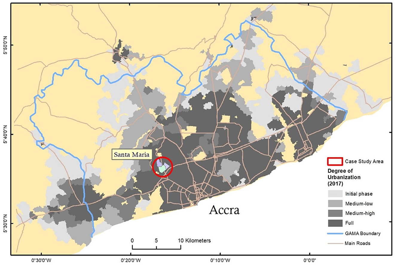
Figure 1. The location of Santa Maria covered by the survey within Accra's historical extent.
Most people in Santa Maria agree that flood problems cannot be solved without demolishing some buildings too close to the streams. However, the authorities have been largely unsuccessful in demolishing these structures. A resident pointed out a narrow area near a stream near his house where a new bridge is being built. Some people are making it difficult for the authorities to demolish the houses in that area. The water from uphill areas is too much, and the narrow channel cannot handle it. Therefore, the water flows into the surrounding areas, causing flooding. The presence of waste in the streams further aggravates the flood risk. Many households in the community do not have access to municipal waste collection services, so they dump waste in the streams. Although the authorities dredged waste and sediments from the streams before the rainy season, they quickly filled them with waste again (Yeboah and Obeng-Odoom, 2010).
Heavy precipitation events cause overflow from rivers and streams, which leads to regular inundation of houses close to streams and numerous flood hotspots affecting interior access roads in Santa Maria. The main outlet road, Kwashieman Road, which connects to the Accra-Tema Motorway and central areas, is also impacted by streamflow. Even the busy trotro station in Santa Maria is regularly affected by floodwater, which constrains the mobility of residents and others who must pass through Santa Maria on their daily trips. The interior access roads within Santa Maria are mostly rough gravel roads with only partial drainage, highly susceptible to erosion. In uphill areas, there is visible evidence of road erosion, with some houses having driveways located well-above the current level of the road. The partial and ad hoc provision of drainage often exacerbates road erosion and contributes to local flood hotspots. Homebuilders have developed small drains along their local roads, which remain unconnected to larger drains and spill onto other roads further downstream.
Essentially, the current governance regime in Santa Maria has led to a limited understanding of and clarity between customary land ownership and land management and has created land problems, including security to title and land speculation (Guest et al., 2006; Acheampong, 2019). These challenges, coupled with Santa Maria's stupendous growth pace, demographically and spatially, and its mushrooming land use planning challenges (Møller-Jensen et al., 2023), justified its choice for this study.
3.2 Research method
Our paper draws on insights from in-depth research in Santa Maria, one of the four research locations at Accra's periphery under the Climaccess Project. The settlement (see Figure 1) is a consolidated one relatively closer to the center, which was incorporated into the built-up area of Accra in the 1990s. Typically, Santa Maria differs from other peri-urban settlements about the extent of ongoing consolidation processes, the coverage of networked infrastructure, the socio-economic profile of homebuilders, the type and quality of housing they develop and the various ways in which the settlement is affected by recurrent flooding during heavy precipitation events.
This study began with a literature review on customary land ownership, administration, and land use planning practices and their relationship with flood risk generation at the local level. The study examined the concepts, theories, and usefulness of land ownership and management regimes in spatial planning. We focused on the local tenets of customary land ownership, land use planning, and development by examining the local authorities' medium-term development plans, reports, and spatial schemes. This was followed by collecting the primary data, which involved two main methods: direct observation and in-depth interviews (Kvale, 2007).
Significantly, the data collection was ethically approved by the University of Ghana Ethics Committee for the Humanities (each 182/17-18) and was carried out during two rounds of fieldwork in January and November–December 2019. During the fieldwork, key informant interviews were conducted with a wide range of local informants (n = 18). Informants include a municipal planning officer (n = 1), an officer from the National Disaster Management Organization (NADMO) (n = 1), members of the municipal assemblies (either elected or running for election) (n = 4), a representative from traditional authorities (n = 1), representatives from residents' associations (n = 3) and representatives from local branches of transport unions such as Ghana's Private Road Transport Union (GPRTU) (n = 7). A total of 18 key informants participated in the formal interviews across the settlement.
The selection of key informants sought to ensure the inclusion of different perspectives on and experiences with flooding within the settlement. The public officials—the municipal planner and NADMO officials—were selected based on their professional positions as civil servants and their specialized knowledge of urban planning and flood risk mitigation. Elected and aspiring members of municipal assemblies were selected based on the political positions they occupy (or wish to occupy) and provided insights on the political priorities of their local constituencies, the relative weight given to recurrent flooding and the range of solutions proposed to mitigate flood risk. Representatives from traditional authorities were selected based on the formal, ceremonial positions they held as chiefs, queen mothers and “gonggon beaters” within the traditional sources laying claim to land and provided insights on land administration, land subdivision processes and the relative weight given to preservation of water retention areas.
The selection of residents' associations sought to ensure coverage of all the active residents' associations organizing individual landowners within the study area. Representatives from residents' associations were selected based on the voluntary positions of trust they hold as elected chairmen, vice-chairpersons or community organizers. They provided insights into their members' experiences with flooding and their priorities for community development. The selection of local branches of transport unions sought to ensure coverage of all the active associations organizing bus and taxi drivers operating and servicing local populations within the study sites. Representatives from local branches of transport unions were selected based on the positions of trust they held as elected chairmen, vice-chairpersons and station managers. They provided insights on their members' experiences with flood impacts on local roads and the implications for the operation of transport services.
Informants do not appear under their names, and recognizable details have been altered to ensure anonymity. All interviews were recorded and transcribed and, when necessary, translated from local languages to English. The interview material was analyzed in QSR Nvivo through an open coding process to systematically analyse data for themes and concepts. Data collection also included extensive field observations, collected independently and accompanied by relevant local informants, to document physical environment characteristics. The research team conducted transect drives/walks with NADMO officials to identify local flood hotspots regularly inundated during heavy precipitation events. The field observations were systematically recorded with GPS track logs, photos and field notes. Field-based data collection is complemented by insights from a recent study (Møller-Jensen et al., 2023), which documents the gradual development of Accra's built-up area based on satellite image analysis.
In the subsequent discussions, we will use the collected data to examine the increasing flood risks in Santa Maria. The community is facing unregulated urbanization, and we want to shed light on the complexities surrounding land ownership and management, which have led to “planning by the commons.” Our analysis will show how fragmented responses to flood risks at the individual level can worsen the problem. Before diving into the details, we will first provide an overview of the interface of land governance and Accra's city-wide urban expansion process. We will also look at how these spatial transformations occur in the context of and contribute to a fragmented urban governance system.
4 Results and discussions
In Ghana, the decentralization concept aims to improve flood risk management for new and established development by involving local authorities and their respective planning authorities and responsibilities. This analysis focuses on the relationship between key stakeholders interested in land use, land governance and spatial planning and how this interface affects local flood risk in Santa Maria.
4.1 The interface of land governance and the consolidation of Santa Maria
Through our analysis of the spatial representation of land use documents, we understood the significance of the policies governing land use planning and management in Accra, as depicted in Figure 2. For instance, the Land Use and Spatial Planning Act 925 of 2016 aims to revise and consolidate land use and spatial planning laws and ensure sustainable land and human settlement development through a decentralized planning system. Furthermore, the Act emphasizes the need for local plans aligned with the evolving transformation of urban areas that reflect local culture. Similarly, the Local Governance Act of 2016 (Act 936) seeks to establish and regulate the local government system to create healthy, safe, and livable communities. It urges local planning authorities to protect and promote their cultural heritage (Government of Ghana, 2016, p. 20).
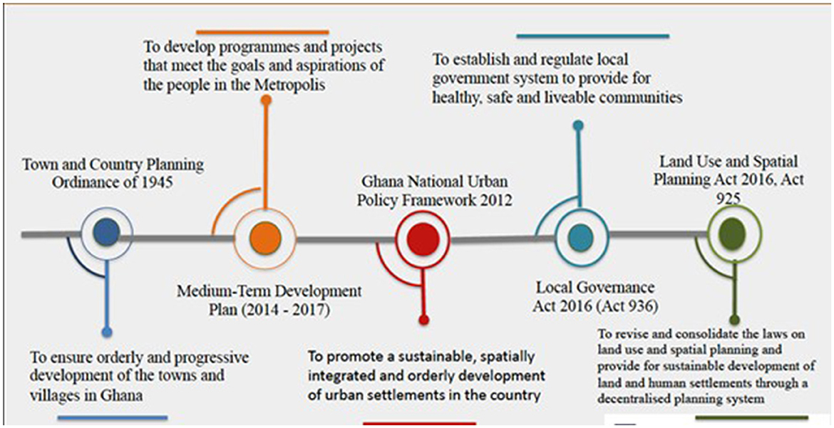
Figure 2. Selected policies governing land-use planning and management in Accra. Source: Compiled by Authors−2021.
Furthermore, the Assembly's Medium-Term Development Plan for 2014–2017 aims to create programmes and projects that align with the goals and aspirations of the local people. Additionally, the National Urban Policy Framework 2012 aims to promote sustainable, orderly development of urban settlements, providing adequate housing and services, efficient institutions, and a sound living and working environment for all people to support Ghana's socio-economic growth. The document acknowledges explicitly that:
“Cities and towns are engines of growth and incubators of civilisation which facilitate the evolution and transmission of knowledge, innovation, culture, industry and commerce” (MLGRD, 2012, p. 20).
The policy objectives suggest that inclusive planning is a conscious effort. However, the rapid growth of cities in an increasingly chaotic, inefficient and unsustainable manner, despite the existence of master plans, indicates a lack of intense political and institutional commitment to officially actualize these policies. According to Anarfi et al. (2020, p. 3), “the dominance of urban politics and neo-liberal urbanism hinders the potential of urban policies to stimulate transformative change in the context of sustainability, [...] the priorities of political actors shape the potential of these policies to deliver transformative sustainability change.” Additionally, Obeng-Odoom (2010) questions whether formulating urban policies alone can create sufficient transformative changes to appropriately address and reflect local conditions.
Similarly, due to Western planning rationalities shaping their perspectives, urban policy planners show limited appreciation of local settlements' social dynamics and lived experiences (Cobbinah et al., 2021). They see self-regulated development efforts as unregulated, disordered, and uncontrolled activities that cause “urban blight” (Watson and Agbola, 2013). Such a perspective is not only at odds with the reality of the local socio-spatial dynamics and practices but also masks the fact that the so-called “disorderliness” and the “violations” of rules and regulations come about as people step outside the law to survive and secure shelter (Watson, 2009). Thus, there is a disjuncture between the rules governing cities and the lived experiences and socio-spatial rationalities that underline the structure of Accra neighborhoods. This mismatch, we argue, stems from the imposition of the Westernized notion of urban order, planning, and regulation, which is often seen as a solution to what Huxley (2006) described as chaos and a “world turned upside down” characteristics of African cities.
It was no surprise when the assembly's participants reflected such imperial influences on planners' perceptions. For example, the physical planning officer cited the main challenges facing land use planning as land ownership and administration. In his opinion, the late introduction of land registration has resulted in boundary claims and counter-claims by clans, families, and individuals overlapping one another, thus presenting such a chaotic picture to make any meaningful interpretation of land ownership almost impossible. The physical planning official affirmed this:
Land ownership in certain areas can become convoluted and intricate, with various parties such as private individuals, families, clans, and divisional chiefs all claiming ownership of the same plot of land. This can result in multiple sales of the same field of land to different buyers, creating a confusing and complicated situation.
Developers must often resort to building haphazardly and defying building regulations to secure their lands. This is known as the “building by the commons approach.” A member of the assembly noted that in Santa Maria, a customary land ownership regime is in operation. Settlers who bought land from the chiefs in the 1990s started selling off parts of their land to make a profit, which led to the debate around building by the commons. In Accra, land ownership is usually divided among different groups through inheritance, such as families, clans, and individuals. This can lead to disagreements between owners over the land's value, resulting in multiple sales of the same plot or disputes over ownership.
In the past, landowners did not document their land, and boundaries were determined by natural means like trees and water bodies. However, the lack of documentation has led to most disputes due to the reduced land and increased value with civilization. Due to the sluggish justice system and encroachment practices, some landowners have hired private security to protect their lands. Today, this measure has evolved into a “Land Guard” syndrome, where these hired security guards carry dangerous weapons like machetes and guns.
The development has led to an unprecedented densification of the settlement. Many structures have been erected in inappropriate places, such as near roads or streams, which hinders efficient development. This is in blatant disregard to the Ghana Riparian Buffer Zone Policy, which partly states: “Enforcing the ‘zone/area of no development' along streams and water bodies by the removal, demolition and the prohibition of unauthorized structures and incompatible land use practices on flood plains, fringes, and corridors” (MWRWH, 2011, p. 12). The practice quickly spurred controversy over the chief's rights to sell land in the first place. He remarked:
Land guards have become more potent than chiefs and are now selling every available parcel of land, including sensitive lands. This has resulted in the invasion of these lands by developers who act with impunity, with the help of the land guards. Consequently, the community is now under serious threat of flooding.
As the comment implies, ownership rights in Santa Maria have historically been unclear. This land issue significantly impacts local planning, making the results of sound land use planning visible only in areas where land ownership is not disputed. Land use planning is the foundation of zoning laws restricting certain developments to protect the environment. Proper planning promotes social engagement, enhances the community, conserves resources, and considers economic, industrial, and transportation needs. Our study indicates successful land use planning is only possible with undisputed lands. Our findings, as well as evidence from other studies (Obeng-Odoom, 2010; Fuseini and Kemp, 2015), highlight how the uncertainties surrounding land ownership have led to the necessity of “land guardians” (armed civilians who protect land) and the construction of unauthorized buildings, which have sterilized buildable land. A trader remarked:
[…] It is important to clarify that many criminals in Accra have relocated to Santa Maria and Sowutoum, which are known to be hideouts for them. Before our relocation, even the area we were occupying was frequently occupied by landguards and drug addicts.
As we conducted our fieldwork, we noticed that the plots' form, shape, and size varied greatly due to the numerous rival claimants. This insecurity forced potential buyers to quickly erect unauthorized structures, disregarding any accepted plan and making it difficult to plan for a healthy and orderly environment. The lack of a well-resourced and functioning land governance system and development leads to deal-making among the influential and financially better-off, sacrificing compliance with the building regulations prescribed by National Building Regulations 1996 (LI 1630). Without proper controls, guidance, and monitoring, we found that the environment is becoming increasingly chaotic, inefficient, and unsustainable, with inadequate provision of open spaces and some homes needing more direct access to roads. Most people are distant from urban infrastructure and need more basic services. This trend is also noticeable in many other cities in Metropolitan Accra (Stacey, 2019; Paller, 2020; Andreasen et al., 2022; Møller-Jensen et al., 2023). This makes it challenging to have a haven to evacuate flood victims.
Meanwhile, our safe analysis shows that Santa Maria is regularly affected by overflow from rivers and streams during heavy precipitation events. Informants report that this causes regular inundation of houses close to streams and numerous flood hotspots affecting interior access roads. The main outlet road, Kwashieman Road, which provides access to the Accra-Tema Motorway and onwards to central areas, is also impacted by overflow from streams. Even the busy trotro station in Santa Maria is regularly affected by floodwater. Consequently, trotro and taxi operators commonly do not enter Santa Maria during heavy precipitation. This constrains the mobility of Santa Maria residents, as well as many others, who need to pass through Santa Maria on their daily trips, as explained by a NADMO officer: [“Last Stop [the trotro station] is very busy, so when it gets flooded, it affects many other communities, who need to pass through Last Stop. That place is very dangerous when it rains, even when using a vehicle.”] Except for Kwashieman Road, interior access roads within Santa Maria are predominantly rough gravel roads with only partial drainage, highly susceptible to erosion. In uphill areas, field observations indicate visible evidence of road erosion, with some houses having driveways located well-above the current level of the road. The partial and ad hoc provision of drainage often aggravates road erosion and contributes to local flood hotspots, i.e., when homebuilders have developed small drains along their own local roads, which remain unconnected to larger drains and consequently spill onto other roads further downstream.
Our findings resonate with Watson's “class of rationalities” and demonstrate the neglect and disconnect between the socio-economic life of unplanned urban peripheries and the formal understanding of spatial planning. The expansion of Santa Maria intensifies the effects of its scourges, particularly inadequate infrastructure and the greater concentrations of people living in flood-prone areas. However, many believe it is worth the risk from the perspective of those who choose to live there. Mitigating flood impacts is possible if flood risk can be estimated and its effects are predictable. Response and recovery are more effective and efficient if the risk process is correctly understood.
4.2 The footprints of (mis)application of land use planning in Santa Maria
The efforts made by traditional authorities to improve the development of communities are well-documented throughout history. However, to continue doing business as usual, where ordinary citizens' capacity and power to take control of the consolidation and formalization of their neighborhoods (referred to as “planning by the commons”) is disregarded entirely, would be a significant challenge for any modern development. Despite numerous planning policies, the findings revealed that Santa Maria has suffered and is still suffering from limited spatial planning. This institutional ambiguity, along with an apparent lack of support and confidence in traditional authorities and ordinary citizens' ability to develop the land, has led to pitting groups of residents against one another and, ultimately, against the planning authorities. As a result, today's rules seem helpless and have become complicit, resulting in situations where residents are sometimes threatened with eviction and demolition. In support of this, a planning official stated:
[…] The issue carries significant weight, especially for those who are less powerful, small-scale actors, and politically and socially marginalised groups. These groups are likely to bear the brunt of the risks involved. This is a complicated situation where landowners differ from those who decide how and for what purposes it should be used. It is a case where the formal planning regimes conflict with indigenous-controlled land ownership regimes.…
The analysis revealed another challenge in Santa Maria (the need for more vacant land), which makes the cost of providing infrastructural services too expensive. The physical planning officer recounted how, within the last 10 years, the community had been ravaged by many attempts to demolish illegally built houses by the assembly and the traditional authorities, as the conflict of interests over land use prevails. The officer remarked:
Our municipality needs a spatial development framework to plan for development effectively. This would allow us to designate areas for specific uses, such as a market, industrial zone, or agricultural land. However, implementing this plan is difficult because the Chiefs have already sold off all the land.
Unfortunately, individuals with low income in Santa Maria have limited options. Increasingly, those struggling financially are being forced out of their more desirable locations due to the purchasing power of others. The settlement needs help to obtain land for necessary infrastructure services due to inadequate development control enforcement. The situation is made worse by land speculators who temporarily take land out of circulation or create disorganized and chaotic development processes. In discussing the consequences of land sterilization, a member of the Unit Committee noted that many people have a natural inclination to own land.:
[…] The desire to own land is so great that many landowners are unwilling to sell, even if they cannot build structures that meet zoning standards. The main challenge in city planning is to establish a solid land governance system that encourages orderly and compact development to prevent the blight of abandoned construction sites and unkempt building plots from spoiling the beauty of an area.
The quote above highlights an interesting point—formal planning can lead to the provision of urban services evenly and at reasonable costs. However, the assembly member pointed out that in areas where individual land ownership is prevalent, lands allocated for public use are often infringed upon by their desperate owners, who have yet to receive statutory compensation. The assembly member argued this point convincingly:
[…] During Acheampong's military regime in 1974, a vast land was obtained to develop an Olympic Stadium in Accra. However, this project was abandoned when constitutional rule was restored, and the traditional authorities were given the power to resell the land.
Although not explored in-depth in this study, the above information shows how party politics affects land governance in Accra. It appears that party politics and the networks between chiefs, public officials, local government, and the communities play a vital role in determining land access and who benefits or loses, as demonstrated by earlier studies (Stacey, 2019; Oteng-Ababio, 2020b). The information presented above highlights Santa Maria as an overcrowded settlement close to major commercial hubs, which continues attracting new residents. However, its reputation is still tarnished by the so-called unregulated development that lacks formal planning. The settlement requires more land for public facilities and recreational spaces because the land was sold off and built upon before the municipality's establishment. As a result, officials have limited authority over development in the community.
4.3 Consolidation of Santa Maria: a product of “planning by the commons”
Our analysis indicates that Santa Maria's ground development rarely follows proper spatial planning. Instead, developers and residents invest in their areas without proper planning, leading to varying degrees of infrastructure, accessibility, service provision, and consolidation. Due to this, the current development dynamics and demographic changes in Santa Maria pose a greater risk of flooding to more people (especially as it is a settlement with contested land rights and limited enforcement of building and planning regulations).
These risks are due to the rapid urbanization, growth of informal settlements, poor urban governance, and deteriorating ecosystems, all of which are aided and reinforced by the settlement's geographical location (in a syncline). Thus, the orthophoto, created from RGB images from uncrewed aerial vehicle (UAV) applications (see Figure 3), illustrates the haphazard and chaotic nature of the area's development crossed by a natural stream. Buildings near and in the waterway and barriers created by clogged drains and narrow bridges provide the basis for frequent flooding and, hence, the rush for individual actions that affect other areas negatively. Additionally, since a significant portion of the population engages in informal business and trading activities in central Accra, localized disasters significantly impact the creation of green space deserts, residents' mobility patterns, and livelihoods due to climate change.
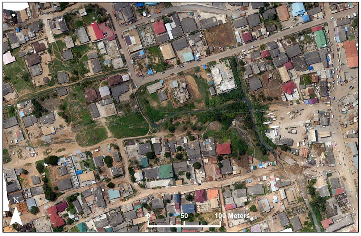
Figure 3. Urban development affects streams and natural waterways, increasing flood vulnerability. Source: Climaccess Project, Trepekli et al. (2021).
The densification of the settlement has had an impact on its environmental, social, and economic aspects. The figure is an orthophoto mosaic covering an area of Santa Maria frequently flooded due to the Laffa stream. The orthophoto is created from RGB images captured by unmanned aerial vehicles (UAVs). The picture illustrates the disorganized and chaotic development in an area crossed by a natural stream. The settlement has experienced extensive urban population growth, accommodated through the proliferation of informal settlements due to the state's limited capacity to administer rapid urbanization. Buildings near and in the waterway (see Figure 4) and barriers created by clogged drains and narrow bridges contribute to frequent flooding, resulting in individual actions that negatively affect other areas.
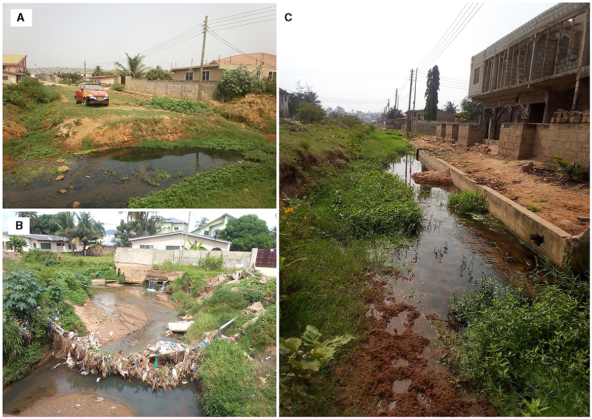
Figure 4. Samples of residents building labeled (A–C) all situated near waterway. Source: Authors' fieldwork.
From the orthophoto, we can robustly identify the settlement's deserts and oases regarding green spaces. Significantly, we perform a social equity analysis to investigate inequality and whether there are systematic (dis)advantages for socioeconomically vulnerable populations to access green spaces in Santa Maria during emergencies. Such a robust green space deserts approach enables more reliable and informed decision-making to enhance green space availability and social equity, facilitating optimal urban policy development for healthy cities. More practically, our analysis of green space availability can be an effective alternative to detect green space deserts when other known guidelines are missing, which is often the case in low- and middle-income countries. In a stakeholders' discussion, an assembly member aspirant alleged:
In Santa Maria today, all available green spaces have been encroached with impunity. Any open space you will find will be completely good for nothing. It will most likely be a floodplain that gets wholly inundated with the slightest downpour, as happens around Mr “P” house (see Figure 5).
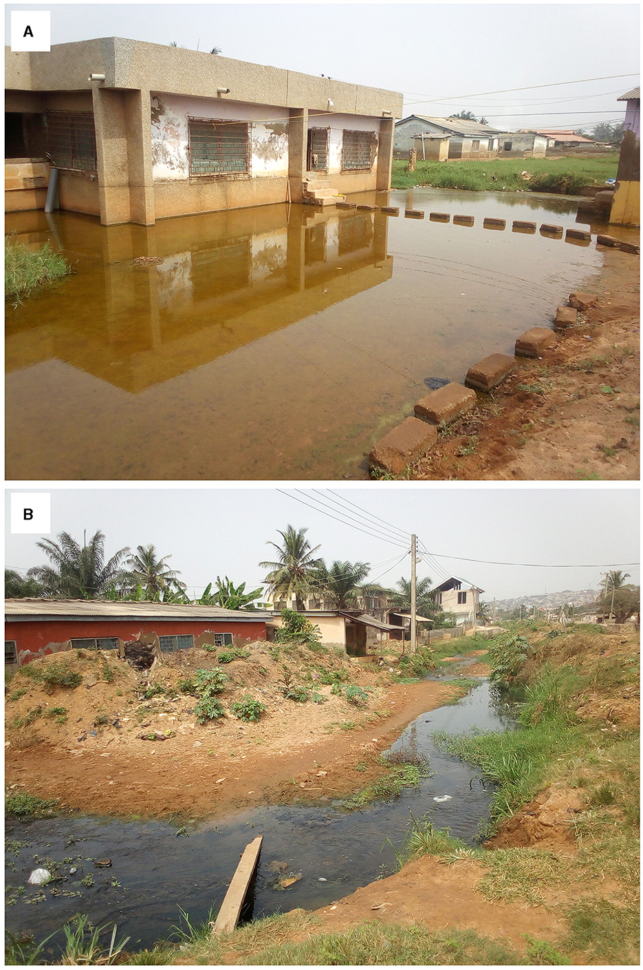
Figure 5. Most open spaces in Santa Maria, including residential, (A, B) are flood-prone. Source: Authors' fieldwork.
During our conversations with the physical planning and NADMO officials, it was acknowledged that Santa Maria had become an increasingly unplanned community. However, neither party admitted the Assembly's involvement in this development. Instead, they confirmed that the community's heightened flood risks were primarily due to unregulated land use and development. The physical planning officer explained:
[…] A significant portion of the land surface is now covered by buildings and other structures, which reduces the capacity to store rainfall. The construction of roads and buildings often involves clearing vegetation, soil, and depressions. This replaces permeable soil with impervious surfaces, which hold very little water, reduce infiltration and accelerate runoff to ditches and streams.
During our interviews, it was unanimously agreed that although severe flooding in Santa Maria is a recent issue, ordinary citizens still need improvement in consolidating their neighborhoods. The lack of legal recognition of the irregular and informal building methods as a fact of contemporary life has led to unregulated building practices, a long-standing issue in Santa Maria. Our interviewees also noted that building in or very close to waterways heavily contributes to the severity of flooding in the area. An official from NADMO corroborated this.:
Many floods occur because buildings constructed in waterways obstruct water flow. To solve this problem, we need to take a bold step and remove those buildings. We cannot allow a few individuals to create issues that affect everyone. The authorities must take action to clear the waterways and solve this problem once and for all.
The earlier comments highlighted that unregulated densification and inadequate drainage systems are the leading causes of flooding in the area. In particular, the NADMO official illustrated how private preventive measures, such as “channeling”, are insufficient to deal with the current maladaptation situation. Such measures inadvertently increase the vulnerability of others. An opinion leader added that the practices of some residents are also responsible for flood occurrences. He explained that the uncontrolled dense networks of self-made ditches and culverts reduce the distance runoff must travel overland and redirect subsurface flow paths to people's homes and workplaces. He concluded:
[…] Many new developers construct gutters that channel flood water out of their homes without considering its impact on adjacent houses. As a result, nearby places often end up receiving the spillover water. To combat floods effectively, the authorities must address this issue of unregulated development without any exceptions or excuses.
During a recent meeting, an Assembly member from Kwashiebu explained how local initiatives in one part of the community often lead to increased flooding in other areas. He pointed out that people tend to develop their lands without considering the impact their actions may have on society. The Assembly member blamed the authorities for complicating their selective interventions. He emphasized the need for better coordination and collaboration between planning officers, traditional authorities, and residents. He suggested that current efforts where residents are left to construct their drains around their homes could be improved.
The findings identified “planning by the commons” as responsible for the spatial expansion of Santa Maria, a region traversed by the Laffa Stream and its tributaries. The settlement's unguided development has led to buildings being erected dangerously close to streams, resulting in severe damage from floodwaters. To protect their homes from shallow flooding, some residents have resorted to private preventive measures, including adding waterproof or flood-resistant veneers to their exterior walls, consisting of a layer of brick backed up by a waterproof membrane, concrete, pressure-treated and marine-grade plywood, and ceramic.
The authorities have been accused of producing flood risks due to their policy-planning-governance complex. Their inaction has led to development occurring in a non-planned and non-transparent manner, increasing people's susceptibility to flooding. The development, coupled with the impact of climate change, has been threatening the infrastructure, operation, policymaking, and other pivotal aspects of transport systems with the accelerating pace of extreme weather events. Our research shows that while considerable research and best practices have been conducted for transport adaptation to climate change impacts, a wide gap exists in the systematic assessment of climate risks on all-round transport modes, as in the case of Santa Maria. Also, the study shows that minor impacts caused by climate change at a single location could significantly influence the entire transport system and its surrounding areas due to cascading effects that inherently characterize these types of climate risks. The NADMO official noted:
In this area [Santa Maria], individuals' self-sufficient constructed drain systems have eventually affected all the road networks. Almost all the internal roads become unmotorable whenever it rains, significantly impacting residents' overall mobility.
Extensive research has undoubtedly been conducted on mobility adaptation to climate change, but it still needs to be more cohesive and balanced. Our “planning by the commons” approach provides a new perspective by demonstrating how destroying primary local mobility modes affects the entire transportation framework's practical functionality and creates green space deserts and livelihood challenges. Our approach offers researchers and practitioners an overview of climate adaptation, the latest empirical insights, and a reliable tool. Decision-makers can use objective data to analyse quantitative risk in rational mobility adaptation planning. Our study aligns with Tibaijuka's (2006) observation that sub-regional planning is often “anti-poor” and can lead to increased social exclusion in cities. Planning officials often have a misconception that “in the planned city... the poor should at best be hidden or at worst swept away,” as Pieterse (2013) observed. Our findings support the assertion that “planning by the commons” and the lack of coherence have contributed to the increasing flooding in Santa Maria, and it is critical to reverse this trend to manage rapid urbanization effectively.
5 Concluding remarks—building a resilient city
This study highlights the limitations of using “planning by the commons” to manage rapid urbanization effectively. Our study demonstrates how such an arbitrary approach leads to individual self-sufficient adaptation strategies, which can impact primary local mobility modes and thus affect the entire transportation framework's practical functionality and create green space deserts and livelihood challenges. Our study revealed that the growth and consolidation of Santa Maria are not without challenges. The analysis showed that the lack of coherence between land governance and spatial planning increases the risk of floods. The mismatch between land ownership and management complicates spatial planning, resulting in poor transport infrastructure and service delivery. Thus, uncontrolled growth of the settlement hinders its sustainable development. Santa Maria exemplifies unguided peripheral growth driven by people's desire to own land. Though building urban resilience is not impossible, the challenges make it costly. Therefore, we must learn from the experience and apply the settlement's insights to other communities in and beyond the metropolis.
Our study acknowledges the tenacity of auto-constructed communities like Santa Maria and suggests incorporating their logic into proposals for consolidation. Instead of seeing them as a problem, “planning by the commons” should be integrated into urban planning that considers locally specific social functions and traditional structures to create equitable and just urban societies. For cities experiencing rapid peripheral urbanization, public investment in citizen skills such as spatial literacy, budget interpretation, and community project management is critical. Building on local capacity, skills, and expertise is essential in creating resilient cities. Santa Maria's experience provides an excellent opportunity for inclusive growth, fulfilling the increasing demand for solutions and services without biases. We need increased policy coherence to achieve better spatial planning and coordination of land-use strategies. Growth management strategies that articulate spatial frameworks, infrastructure plans, land assembly strategies, and resource efficiency targets connected to innovative financing tools will need to be produced for all major cities and towns. We can learn from the experiences of Latin American countries, especially Brazil, with master planning and social zoning to reinforce neighborhood-level planning and community management systems.
Incorporating DRR into local development plans is essential to improve self-reliance and resilience. This involves identifying small measures for local protection, services, and mutual assistance. Communities must collaborate and create joint ventures to reduce flood costs. Vulnerability impacts of planned development projects should be screened, and disaster responsibility should be integrated into all sectors of development activity. Our analysis indicates that separating disaster risks from their social contexts and treating them as administrative responsibilities exacerbates the problem. Therefore, it is necessary to restructure community development to reduce vulnerability and promote survival purposefully. Planning should focus on strengthening the ability to respond to and absorb the effects of a local disaster event in a timely and efficient manner and sustaining this ability in the future. The study suggests that extreme climatic phenomena, such as rainfall, may have increased in frequency in recent years. However, the highly vulnerable flood context of Santa Maria cannot be explained by the sole effect of increased rain. Meteorological events affect already damaged systems. Community-driven planning and management methodologies, such as those used in Brazilian favelas, can offer crucial insights (Comaroff and Comaroff, 2012). African cities can draw on the rich tradition of participatory design that has become the hallmark of radical incrementalism across many Latin American cities, according to Pieterse (2013).
Identifying key stakeholders and involving them in the development process from the outset is crucial to changing the mindsets of policymakers and citizens. This will help them to develop a fondness for their cities and become part of the solution to building urban resilience. While the above principles do not encompass all the necessary steps in creating a resilient city, prioritizing them is essential to making a meaningful and sustainable difference. Trusting in the ability and power of ordinary people to take control of their neighborhoods' consolidation and incremental formalization is a step closer to finding a lasting solution to Accra's devastating flooding, especially in light of the lack of clear guidelines for resolving the land tenure (ownership and management dilemma) commonly observed in low- and middle-income countries. Ultimately, this research contributes to developing urban policies that promote healthy cities, enhance infrastructure provision, and encourage social equity.
Data availability statement
The datasets presented in this article are not readily available due to considerations related to individual protection and privacy concerns. Requests to access the datasets should be directed to the corresponding author.
Ethics statement
The studies involving human participants were reviewed and approved by University Of Ghana Ethics Committee for the Humanities (ECH) Ethical Clearance (ECH 182/ 17-18). Written informed consent for participation was not required for this study in accordance with the national legislation and institutional requirements.
Author contributions
The paper comes from a project in which all authors participated actively in the data collection. Additionally, the authors collectively participated actively in the conceptualization, drafting, and editing the paper. All authors contributed to the article and approved the submitted version.
Funding
The research was funded by a grant awarded by the Danish Ministry of Foreign Affairs (DFC file no. 17-01-ku).
Conflict of interest
The authors declare that the research was conducted in the absence of any commercial or financial relationships that could be construed as a potential conflict of interest.
Publisher's note
All claims expressed in this article are solely those of the authors and do not necessarily represent those of their affiliated organizations, or those of the publisher, the editors and the reviewers. Any product that may be evaluated in this article, or claim that may be made by its manufacturer, is not guaranteed or endorsed by the publisher.
References
Abass, K., Buor, D., Afriyie, K., Dumedah, G., Segbefi, A. Y., Guodaar, L., et al. (2020). Urban sprawl and green space depletion: implications for flood incidence in Kumasi, Ghana. Int. J. Disast. Risk Reduct. 51:101915. doi: 10.1016/j.ijdrr.2020.101915
Ablo, A. D., Asem, F. E., Yiran, G. A. B., and Owusu, G. (2020). “Urban sprawl, land use change and the changing rural agrarian livelihood in peri-urban Accra, Ghana,” in Rural-Urban Linkages and Sustainable Development: Case Studies from Africa, Vol. 6, eds F. Kapfudzaruwa, S. Kudo, K. Matsuyama, and D. I. Allasiw (Spears Media Press).
Acheampong, R. A. (2019). “Historical origins and evolution of spatial planning and the planning system in Ghana,” in Spatial Planning in Ghana (Cham: Springer), 29–56.
Agergaard, J., Kirkegaard, S., and Birch-Thomsen, T. (2021). Between village and town: small-town urbanism in Sub-Saharan Africa. Sustainability 13:1417. doi: 10.3390/su13031417
Alvarez, M. K., and Cardenas, K. (2019). Evicting slums, 'building back better: resiliency revanchism and disaster risk management in Manila. Int. J. Urban Reg. Res. 43, 227–249. doi: 10.1111/1468-2427.12757
Amoako, C., and Inkoom, D. K. B. (2018). The production of flood vulnerability in Accra, Ghana: Re-thinking flooding and informal urbanisation. Urban Stud. 55, 2903–2922. doi: 10.1177/0042098016686526
Anarfi, K., Shiel, C., and Hill, R. A. (2020). Assessing how sustainability is promoted in Ghana's National urban policy and action plan. Sustainability 12:7556. doi: 10.3390/su12187556
Andreasen, M. H., Agergaard, J., Allotey, A. N., Møller-Jensen, L., and Oteng-Ababio, M. (2023). “Built-in flood risk: the intertwinement of flood risk and unregulated urban expansion in african cities,” in Urban Forum, Vol. 34 (Dordrecht: Springer), 385–411. doi: 10.1007/s12132-022-09478-4
Andreasen, M. H., Agergaard, J., Møller-Jensen, L., Oteng-Ababio, M., and Yiran, G. A. B. (2022). Mobility disruptions in Accra: recurrent flooding, fragile infrastructure and climate change. Sustainability 14:13790. doi: 10.3390/su142113790
Asafo, D. M. (2022). Fragile and compromised housing: implications of land conflicts on housing development in peri-urban Accra, Ghana. Hous. Stud. 1–24. doi: 10.1080/02673037.2022.2119209
BBC (2015). Ghana Petrol Station Inferno Kills About 150 in Accra. BBC. Available online at: http://www.bbc.com/news/world-africa-33003673 (accessed June 5, 2015).
Boamah, N. A., Gyimah, C., and Nelson, J. K. B. (2012). Challenges to the enforcement of development controls in the Wa municipality. Habit. Int. 36, 136–142. doi: 10.1016/j.habitatint.2011.06.010
Boamah, F. (2014). How and why chiefs formalise land use in recent times: the politics of land dispossession through biofuels investments in Ghana. Rev. Afr. Polit. Econ. 41, 406–423. doi: 10.1080/03056244.2014.901947
Cobbinah, P. B., Asibey, M. O., and Gyedu-Pensang, Y. A. (2020). Urban land use planning in Ghana: navigating complex coalescence of land ownership and administration. Land Use Policy 99:105054. doi: 10.1016/j.landusepol.2020.105054
Cobbinah, P. B., Asibey, M. O., Zuneidu, M. A., and Erdiaw-Kwasie, M. O. (2021). Accommodating green spaces in cities: perceptions and attitudes in slums. Cities 111:103094. doi: 10.1016/j.cities.2020.103094
Comaroff, J., and Comaroff, J. L. (2012). “Theory from the South: or, how euro-America is evolving toward Africa,” in Anthropological Forum, Vol. 22 (Routledge), 113–131.
Denchie, E. O., Ablo, A. D., and Overå, R. (2021). Land governance and access dynamics in Sekondi-Takoradi, Ghana. Afr. Geogr. Rev. 40, 364–377. doi: 10.1080/19376812.2020.1831560
Esson, J., Gough, K. V., Simon, D., Amankwaa, E. F., Ninot, O., and Yankson, P. W. (2016). Livelihoods in motion: linking transport, mobility and income-generating activities. J. Trans. Geogr. 55, 182–188. doi: 10.1016/j.jtrangeo.2016.06.020
Förster, T., and Ammann, C. (2018). African cities and the development conundrum. Int. Dev. Policy 10, 3–25 doi: 10.4000/poldev.2621
Fuseini, I., and Kemp, J. (2015). A review of spatial planning in Ghana's socio-economic development trajectory: a sustainable development perspective. Land Use Policy 47, 309–320. doi: 10.1016/j.landusepol.2015.04.020
Government of Ghana (2016). Land Use and Spatial Planning Act, 2016 (ACT 925). Ghana Publishing Company Limited, Assembly Press, Accra-Ghana. GPCL/A728/1,500/09/2016.
Guest, G., Bunce, A., and Johnson, L. (2006). How many interviews are enough? An experiment with data saturation and variability. Field Methods 18, 59–82. doi: 10.1177/1525822X05279903
Hammond, D. N. A. (2011). “Harmonising Land policy and the law for development in Kumasi,” in Future of the Tree. Towards Growth and Development of Kumasi, ed Adarkwa (Kumasi: University Printing Press KNUST).
Hornby, D., Kingwill, R., Royston, L., and Cousins, B., (eds.). (2017). Untitled: Securing Land Tenure in Urban and Rural South Africa. University of KwaZulu-Natal Press.
Huxley, M. (2006). Spatial rationalities: order, environment, evolution and government. Soc. Cult. Geogr. 7, 771–787. doi: 10.1080/14649360600974758
IPCC (2007). Climate Change 2007: Synthesis Report. Contribution of Working Groups I, II and III to the Fourth Assessment Report of the Intergovernmental Panel on Climate Change IPCC, Geneva.
IPCC (2018). “Summary for policymakers,” in Global Warming of 1.5 °C. An IPCC Special Report on the Impacts of Global Warming of 1.5 °C Above Pre-Industrial Levels and Related Global Greenhouse Gas Emission Pathways in the Context of Strengthening the Global Response to the Threat of Climate Change, Sustainable Development, and Efforts to Eradicate Poverty, eds V. Masson-Delmotte, P. Zhai, H.-O. P?rtner, D. Roberts, J. Skea, P. R. Shukla, A. Pirani, W. Moufouma-Okia, C. P?an, R. Pidcock, S. Connors, J. B. R. Matthews, Y. Chen, X. Zhou, M. I. Gomis, E. Lonnoy, T. Maycock, M. Tignor, and T. Waterfield (Geneva: World Meteorological Organization), 32.
Kansanga, M. M., Ahmed, A., Kuusaana, E. D., Oteng-Ababio, M., and Luginaah, I. (2020). Of waste facility siting and relational geographies of place: peri-urban landfills, community resistance and the politics of land control in Ghana. Land Use Policy 96:104674. doi: 10.1016/j.landusepol.2020.104674
Kasanga, K., and Kotey, N. A. (2001). Land Management in Ghana: Building on Tradition and Modernity. London: International Institute for Environment and Development.
Kemajou, A., Konou, A. A., Jaligot, R., and Chenal, J. (2020). Analysing four decades of literature on urban planning studies in Africa (1980–2020). Afr. Geogr. Rev. 1–19. doi: 10.1080/19376812.2020.1844025
Kim, J. Y. (2019). The World Bank Annual Report 2019: Ending Poverty. Investing in Opportunity; World Bank Annual Report. Washington, DC: The World Bank.
Kvale, S. (2007). Dominance through interviews and dialogues. Qual. Inq. 12, 480–500. doi: 10.1177/1077800406286235
Lawhon, M., Ernstson, H., and Silver, J. (2014). Provincialising urban political ecology: towards a situated UPE through African urbanism. Antipode 46, 497–516. doi: 10.1111/anti.12051
Lombard, J., and Ninot, O. (2012). From mobility to transport. Perspectives in West Africa. EchoGéo. doi: 10.4000/echogeo.13286
Mabin, A., Butcher, S., and Bloch, R. (2013). Peripheries, suburbanises and change in sub-Saharan African cities. Soc. Dyn. 39, 167–190. doi: 10.1080/02533952.2013.796124
McCartney, S., and Krishnamurthy, S. (2018). Neglected? Strengthening the morphological study of informal settlements. SAGE Open 8:2158244018760375. doi: 10.1177/2158244018760375
MLGRD (2012). Environmental Sanitation Policy (Revised 2009). Accra: Ministry of Local Government and Rural Development, Government of Ghana.
Møller-Jensen, L., Agergaard, J., Andreasen, M. H., Kofie, R. Y., Yiran, G. A., and Oteng-Ababio, M. (2023). Probing political paradox: Urban expansion, floods risk vulnerability and social justice in urban Africa. J. Urban Aff. 45, 505–521. doi: 10.1080/07352166.2022.2108436
MWRWH (2011). Riparian Buffer Zone Policy for Managing Freshwater Bodies in Ghana. Ministry of Water Resources Works and Housing.
Okyere, A. S., and Kita, M. (2015). Rethinking urban informality and informal settlements growth in urban Africa: a literature discussion. J. Sustain. Dev. Africa 17, 101–124.
Oteng-Ababio, M. (2011). Beyond technical details: the stalled Kwabenya engineered sanitary landfill project in Accra, Ghana. Geografisk Tidsskrift Danish J. Geogr. 111, 169–179. doi: 10.1080/00167223.2011.10669531
Oteng-Ababio, M. (2013a). “Prevention is better than cure”: assessing Ghana's preparedness (capacity) for disaster management, Jàmbá 5:11 doi: 10.4102/jamba.v5i2.75
Oteng-Ababio, M. (2013b). Unscripted (in) justice: exposure to ecological hazards in metropolitan Accra. Environ. Plann. A 45, 1199–1218. doi: 10.1068/a45256
Oteng-Ababio, M. (2020a). The quest for efficient waste management architecture in Ghana. Field Act. Sci. Rep. 22, 24–29.
Oteng-Ababio, M. (2020b). Dispelling common misconceptions to improve policy outlook in developing countries. Ghana Soc. Sci. J. 17, 15–15.
Owusu, G., and Oteng-Ababio, M. (2015). Moving unruly contemporary urbanism toward sustainable urban development in Ghana by 2030. Am. Behav. Sci. 59, 311–327. doi: 10.1177/0002764214550302
Paller, J. W. (2020). Everyday politics and sustainable urban development in the Global South. Area Dev. Policy 6, 319–336.
Ramiaramanana, F. N., and Teller, J. (2021). Urbanization and floods in sub-saharan africa: Spatiotemporal study and analysis of vulnerability factors-case of antananarivo agglomeration (Madagascar). Water 13, 149. doi: 10.3390/w13020149
Saghir, J., and Santoro, J. (2018). “Urbanisation in Sub-Saharan Africa,” in Meeting Challenges by Bridging Stakeholders. Washington, DC: Center for Strategic & International Studies.
Stacey, P. (2019). State of Slum: Precarity and Informal Governance at the Margins in Accra. Zed Books, 225.
Tibaijuka, A. (2006). Statement by Under-Secretary-General of the United Nations Executive Director of UN-HABITAT “Urbanisation in Low-Income Countries – Some Critical Issues”. Available online at: https://mirror.unhabitat.org/content.asp?cid=5370&catid=649&typeid=8 (accessed August 12, 2023).
Trepekli, K., Fog, B., and Møller-Jensen, L. (2021). Methods for Processing and Analysing UAV-Retrieved Lidar and Rgb Data Covering Selected Areas in Accra. Available online at: www.ign.ku.dk/climaccess
Turok, I. (2016). Getting urbanisation to work in Africa: the role of the urban land- infrastructure-finance nexus. Area Dev. Policy 1:30–47. doi: 10.1080/23792949.2016.1166444
Turok, I., and McGranahan, G. (2013). Urbanization and economic growth: the arguments and evidence for Africa and Asia. Environ. Urban. 25, 465–482. doi: 10.1177/0956247813490908
UN-HABITAT (2016). World Cities Report 2016; Urbanization and Development-Emerging Futures. United Nations.
UNISDR (2015). “Sendai framework for disaster risk reduction 2015–2030,” in UN world Conference on Disaster Risk Reduction, March 14–18, Sendai, Japan. The United Nations Office for Disaster Risk Reduction. Available online at: http://www.wcdrr.org/uploads/Sendai_Framework_for_Disaster_Risk_Reduction_2015-2030.pdf (accessed January 18, 2016).
Watson, V. (2009). ‘The planned city sweeps the poor away...': Urban planning and 21st century urbanisation. Prog. Plan. 72, 151–193. doi: 10.1016/j.progress.2009.06.002
Watson, V. (2021). The return of the city-region in the new urban agenda: is this relevant in the Global South? Reg. Stud. 1, 19–28. doi: 10.1080/00343404.2019.1664734
Watson, V., and Agbola, B. (2013). Who Will Plan Africa's Cities? Africa Research Institute, Understanding Africa Today. Cape Town. Available online at: http://www.africaresearchinstitute.org/publications/who-will-plan-africas-cities/ (accessed May 10, 2015).
Keywords: spatial planning, land governance, Institutional ambiguity, Planning by the Commons, Urban floods
Citation: Oteng-Ababio M, Agergaard J, Møller-Jensen L and Andreasen MH (2024) Flood risk reduction and resilient city growth in sub-Saharan Africa: searching for coherence in Accra's urban planning. Front. Sustain. Cities 6:1118896. doi: 10.3389/frsc.2024.1118896
Received: 08 December 2022; Accepted: 19 January 2024;
Published: 23 February 2024.
Edited by:
Ruth Massey, University of Huddersfield, United KingdomReviewed by:
Robert Home, Anglia Ruskin University, United KingdomGiulio Castelli, University of Florence, Italy
Mohanasundar Radhakrishnan, IHE Delft Institute for Water Education, Netherlands
Copyright © 2024 Oteng-Ababio, Agergaard, Møller-Jensen and Andreasen. This is an open-access article distributed under the terms of the Creative Commons Attribution License (CC BY). The use, distribution or reproduction in other forums is permitted, provided the original author(s) and the copyright owner(s) are credited and that the original publication in this journal is cited, in accordance with accepted academic practice. No use, distribution or reproduction is permitted which does not comply with these terms.
*Correspondence: Martin Oteng-Ababio, bW90ZW5nLWFiYWJpb0B1Zy5lZHUuZ2g=