 Haya M. Alogayell1
 Mona S. Ramadan
- 1Department of Geography and Environmental Sustainability, Faculty of Humanities and Social Sciences, Princess Nourah bint Abdulrahman University, Riyadh, Saudi Arabia
- 2Water Resources Research Institute, National Water Research Center,El-Qanater El-Khairiya, Egypt
- 3Geography and Urban Sustainability Department, College of Humanities & Social Sciences, UAE University, Al Ain, United Arab Emirates
- 4Urban Planning Department, Environmental Studies and Land Use Division, National Authority for Remote Sensing and Space Sciences (NARSS), Cairo, Egypt
- 5Khatib & Alami, Water Resources and Stormwater, Beirut, Lebanon
This research presents a GIS-based approach to evaluate land suitability for the urbanization of Saudi Arabia’s NEOM region, an ambitious initiative for sustainable development within a desert setting. By employing a multi-criteria decision-making framework, we have synthesized data on land resources, stability, accessibility, construction costs, and proximity to conservation areas using the Analytical Hierarchy Process (AHP) to prioritize these factors based on their importance for sustainable growth. Our analysis reveals that areas designated with grid values of 9 and 8, totaling 6312.33 square kilometers or 28.23% of the area studied, are most favorable for urban development. These sectors span the northern, central, and southern parts of NEOM, which are notable for their strategic location near future infrastructure and natural assets conducive to sustainable practices. This finding supports NEOM’s key initiatives such as “The Line,” “Oxagon,” and “TROJENA,” showcasing the model’s utility in directing urban development strategies. The study discusses the broader socio-economic and environmental ramifications of pinpointing areas suited and unsuited for development, underlining the model’s role in facilitating decision-making that aligns urban expansion with environmental stewardship. Furthermore, it advocates for leveraging development-restricted zones in conservation efforts and renewable energy ventures. Nevertheless, the study concedes certain limitations, such as the dependence on static datasets and inherent challenges related to the AHP method, including the presumption of criteria independence. Future research avenues are proposed, emphasizing the integration of dynamic data sources, comprehensive socio-cultural impact evaluations, and adopting flexible urban planning methodologies to refine the model’s precision and practicality. Overall, this detailed examination showcases NEOM’s blueprint as an exemplar for future urban environments, illustrating a systematic strategy for developing desert regions that integrate innovation, ecological sustainability, and the preservation of cultural heritage.
1 Introduction
Launched by the Saudi government on 24 October 2017, the NEOM Region initiative symbolizes a commitment to development and aligns with international endeavors to transform urban landscapes for the 21st century. This initiative is part of a global movement where countries are pioneering the future of urban living. NEOM aims to establish Saudi Arabia as a leader in this global trend, drawing on both its unique cultural heritage and similarities with initiatives such as Dongtan in China, Egypt’s Smart Village, and Masdar City in the UAE (Powell, 2022). NEOM is envisioned as a beacon of innovation and environmental stewardship, setting a new standard for regional development in harmony with sustainability goals prevalent across global megacities (Brochure, 2018).
The pursuit of sustainable urban development, particularly in challenging environments, is a common thread among various global projects, including NEOM (Aina, 2017). From Masdar City’s focus on zero-carbon living to Dongtan’s ambition for a sustainable rural–urban blend and the Smart Village’s technology-centric business model, these initiatives, though varied, share NEOM’s vision for a sustainable and innovative future.
1. Masdar City, UAE: Since its inception in 2006, Masdar City has stood as a pioneer in sustainable urban development, striving for a zero-carbon and zero-waste ecosystem driven by renewable energy (Sankaran and Chopra, 2020). Unlike NEOM, which integrates the latest technologies into its urban fabric, Masdar employs traditional designs for natural cooling and energy efficiency (Yusuf and Abdulmohsen, 2022).
2. Dongtan, China: Envisioned as an eco-city that marries urban living with rural tranquility, Dongtan aims for self-sufficiency and minimal environmental impact (Wang and Mell, 2019), paralleling NEOM’s sustainability goals but placing greater emphasis on agricultural integration (Yusuf and Abdulmohsen, 2022).
3. Smart Village, Egypt: As a technological hub outside Cairo, the Smart Village mirrors one of NEOM’s objectives to foster a tech-driven business environment (Abusaada et al., 2023). However, it does not aspire to NEOM’s broader goal of creating a comprehensive urban ecosystem.
Furthermore, the NEOM project resonates with global development agendas advocated by UN-affiliated organizations, focusing on sustainable urbanization and addressing core issues such as poverty, healthcare, and environmental sustainability (Boelt, 2014).
Urban development in deserts introduces unique challenges (Ramadan and Effat, 2021), including water scarcity, extreme climates, environmental conservation, and the need for sustainable resource management. These obstacles necessitate innovative solutions in areas such as water management, urban design, and infrastructure resilience. Key issues include water scarcity: intrinsic water shortages in deserts demand sustainable management practices such as desalination, water recycling, and rainwater harvesting to ensure a sufficient supply for urban needs (Alkhalidi et al., 2018; Amr, 2023); extreme climate: deserts’ severe heat and sunlight require urban designs and building materials that offer cooling and comfort with minimal energy use, highlighting the importance of innovative architecture and renewable energy (Günel, 2019; Ramadan R. H. et al., 2022; Kutty et al., 2023); environmental conservation: the unique biodiversity in deserts calls for a careful balance between development and the preservation of natural habitats to prevent ecological degradation (Sankaran and Chopra, 2020; Effat et al., 2022); sustainable resource use: limited natural resources in deserts necessitate a sustainable approach in all urban development facets, from energy to waste management, incorporating renewables and efficient recycling systems (Alshammari, 2019); infrastructure durability: creating infrastructure that can endure desert conditions without significant maintenance poses a challenge, necessitating materials and designs resistant to sand erosion, heat, and UV exposure (Riadh, 2022).
Addressing these challenges, nations have turned to technologies such as geographic information systems (GIS) for planning and analysis (Taiema and Ramadan, 2021). GIS’s role in assessing land use suitability has become indispensable, aligning with research that underscores NEOM’s innovative development strategies. Such approaches provide a blueprint for resource utilization that satisfies current needs without compromising future generations’ capabilities (Brown, 2006). GIS is pivotal in urban planning, enabling informed decisions that balance social and economic impacts with environmental sustainability (GIS) (Mishra, 2023). The analysis of data, when combined with methods for evaluating criteria has shown its value in addressing issues related to land use and reducing the environmental effects of spatial planning (Saiu et al., 2022). Geographic Information Systems (GIS) have proven to be tools in planning and handling, particularly when it comes to mapping and analyzing the suitability of land use (Lasaiba, 2023). Basically, the objective of land use suitability analyses is to figure out how to arrange types of land uses in the future, taking into account priorities or factors related to certain objectives (Abdullahi et al., 2015; AbdelRahman et al., 2016; González-Méndez et al., 2021; Ramadan M. S. et al., 2022). GIS, depending on an analysis of land use suitability, has been successfully employed in contexts, such as defining habitats for animal and plant species from an ecological perspective (Hakam et al., 2023; Rana and Moniruzzaman, 2023; Watuwaya et al., 2023), determining geological favorability (Lötz, 2023), assessing agricultural suitability (Anusha et al., 2023; Batool et al., 2023), evaluating landscapes for planning purposes (Latue and Rakuasa, 2023; Machireddy, n.d.), and conducting environmental impact assessments (Bourbonnais, 2022; Xie et al., 2022).
This study leverages remote sensing technology and GIS to explore development potentials in Saudi Arabia’s NEOM region, aiming to identify optimal locations for community establishment. By considering factors such as accessibility, land stability, and natural resources, we employ a GIS-based model to highlight suitable areas for urban development, aligning with NEOM’s innovative and sustainable vision.
NEOM distinguishes itself by aiming to construct a comprehensively smart city in the desert, merging sustainability, technological progress, economic diversification, and social welfare from the outset. Our methodology, especially our GIS-based land suitability model combined with the Analytical Hierarchy Process (AHP), represents a novel approach to sustainable urban development. This method’s thorough integration of diverse data and systematic assessment of development suitability uniquely addresses NEOM’s challenges, positioning this research at the forefront of futuristic city planning in arid landscapes. Furthermore, this study contributes to achieving Sustainable Development Goal 11: creating inclusive, safe, resilient, and sustainable urban spaces.
Addressing desert urban development’s specific challenges, this study aims to:
1. Develop a GIS-based model incorporating diverse datasets to pinpoint optimal development locations.
2. Use AHP to prioritize factors crucial to urban development in deserts, such as water scarcity and energy sustainability.
3. Recommend design and planning strategies tailored to desert environments, emphasizing conservation and efficiency.
4. Assess environmental impacts, aiming for a minimal ecological footprint and enhanced natural habitat preservation.
By integrating remote sensing technology and GIS, this research endeavors to identify strategic development areas in NEOM, considering factors such as accessibility, resource availability, and ecological sensitivity, thereby advancing the vision of establishing thriving communities in Saudi Arabia’s desert landscapes.
2 Data acquisition and methods
2.1 Study area
The NEOM Region, located in northwest Saudi Arabia, has been designated as an area that combines economic, commercial, and tourist activities. It is located within Tabuk Province, covering a space of 136,000 kilometers. It shares borders with Egypt and Jordan and is 50 kilometers away from Tabuk City. The NEOM Region, which was planned to span an area of 26,500 kilometers, stretches along the Red Sea coastline for about 225 kilometers. In terms of its positioning, it lies between the coordinates of 27° 43′ 27” N and 29° 08′ 29” N, and 34° 31′ 40″ E and 35° 57′ 55″ E (Figure 1).
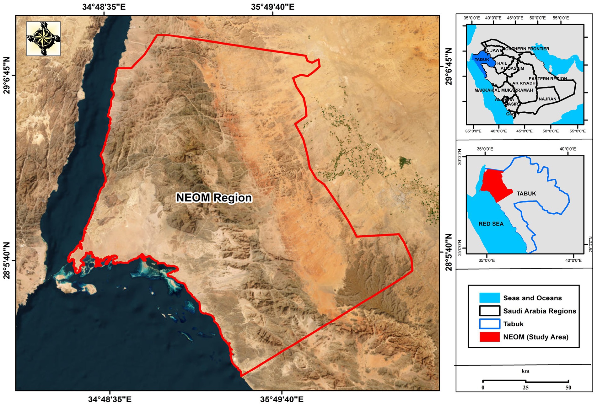
Figure 1. Location of the study area.
The region has some features that make it stand out. It acts as a connecting point between Asia and Africa, serving as a link between the Mediterranean Sea and the Red Sea. Approximately 10% of global trade passes through this area. Its diverse geography includes altitudes surpassing 2,500 meters, which leads to plant and animal life and various weather conditions. The NEOM Region contains heritage sites that represent different civilizations throughout history. It is abundant in resources and ore deposits with many other potential resources yet to be explored and utilized. The NEOM Region has the potential to become a hub in the part of Saudi Arabia. Despite covering 18% of Tabuk Province, its unique natural features make it one of the most noteworthy and exceptional regions, in the whole Kingdom. Tabuk Province is well known for its coastline, which stretches for 648 kilometers. Approximately 38% of Saudi Arabia’s coastline is encompassed by this, which includes the Gulf of Aqaba and the Red Sea. It is important to mention that the NEOM Region alone accounts for 40% of the coastline in Tabuk Province.
The NEOM Region comprises villages over 25, with each village having a population of more than 1,000 residents. Al Sharaf and Al Bada’a are actually within the NEOM Region, while the rest of the towns are positioned along the coastline. These coastal towns include Maqna, Ayeynat, Al Khrierbah, Gayal, Sharma, Al Sarah, and Al Muwieleh. They stretch from north to south. Among these towns, Al Bada’a is notable as it is the governorate (Mohafazat) in the NEOM Region and has a population of 13,000. Sharma City is home to around 5,000 people. The remaining towns have populations of more than 3,000 each. Overall, it is estimated that the total population in both villages and towns in the NEOM Region does not exceed 60,000 individuals. The low population density reflects that the region is still relatively undeveloped and sparsely populated, with 2 people per square kilometer. It is important to note that non-Saudi citizens make up 20% of the population in Tabuk and these mentioned towns (Arabia, 2016).
Human movement in the NEOM Region is mainly concentrated in the coastal zone, with fewer human activities observed in the other areas due to their rugged topography. As a result, the coastal zone stands out with its coasts and unique coral reefs attracting numerous tourists and hosting various resorts. Fishing is also an occupation in the zone of NEOM. In terms of agriculture, most farming activities occur in the zone and on plateaus along the roads leading to Tabuk. Here, you will find cultivated palm trees, mangoes, and oranges alongside other field crops and seasonal plantings. The region is renowned for its sites and cultural heritage spots, such as Maghayer Chouaieb in Al Bada’a and Bir Al Sa’aidani in Maqna. The NEOM Region enjoys transportation connections as it serves as a route between Jordan and other important Saudi hubs. The Al Durrah border crossing is located 50 kilometers away from the NEOM border, while the significant Duba Port is situated 15 kilometers to its south.
2.2 Data acquisition
In our comprehensive study, we meticulously examined various segments such as land utilization, agricultural zones, urban development, and water resources. This detailed analysis was primarily facilitated through the examination of satellite imagery, notably:
Satellite Imagery from Sentinel-2 (2023): We procured satellite imagery of the NEOM region from the Sentinel-2 satellite, captured in 2023, with a resolution of 10 meters. This imagery played a crucial role in providing a thorough overview of the entire area. To refine the data, we employed the FLAASH module within ENVI 5.1 software to eliminate any atmospheric disturbances and involved subsequent steps using Mosaicking techniques to merge different satellite scenes into a cohesive image. Leveraging the Support Vector Machine (SVM) model for image classification, we successfully segmented the integrated images into distinct categories, namely land, urban areas, water bodies, and desert regions, using the ENVI 5.1 tool for this intricate task.
Data from the Shuttle Radar Topography Mission (SRTM): The SRTM data was pivotal in extracting the Digital Elevation Model (DEM), with a resolution of 30 meters, shedding light on the topographical details such as elevation differences, slope gradients, orientations, and the intricate network of streams. This intricate dataset required sophisticated processing, accomplished through the ESRI Spatial Analyst toolkit, enhancing our understanding of the physical landscape.
Further exploration into the NEOM Region was enriched by thematic maps sourced from specialized agencies (as listed in Table 1). These maps, originally in hard copy form, underwent digital transformation. The process involved scanning, correcting imperfections, and converting them into digital format using the widely recognized ArcGIS 10 software. This conversion process rendered the maps into shapefiles, stored within a database for subsequent analysis and exploration.
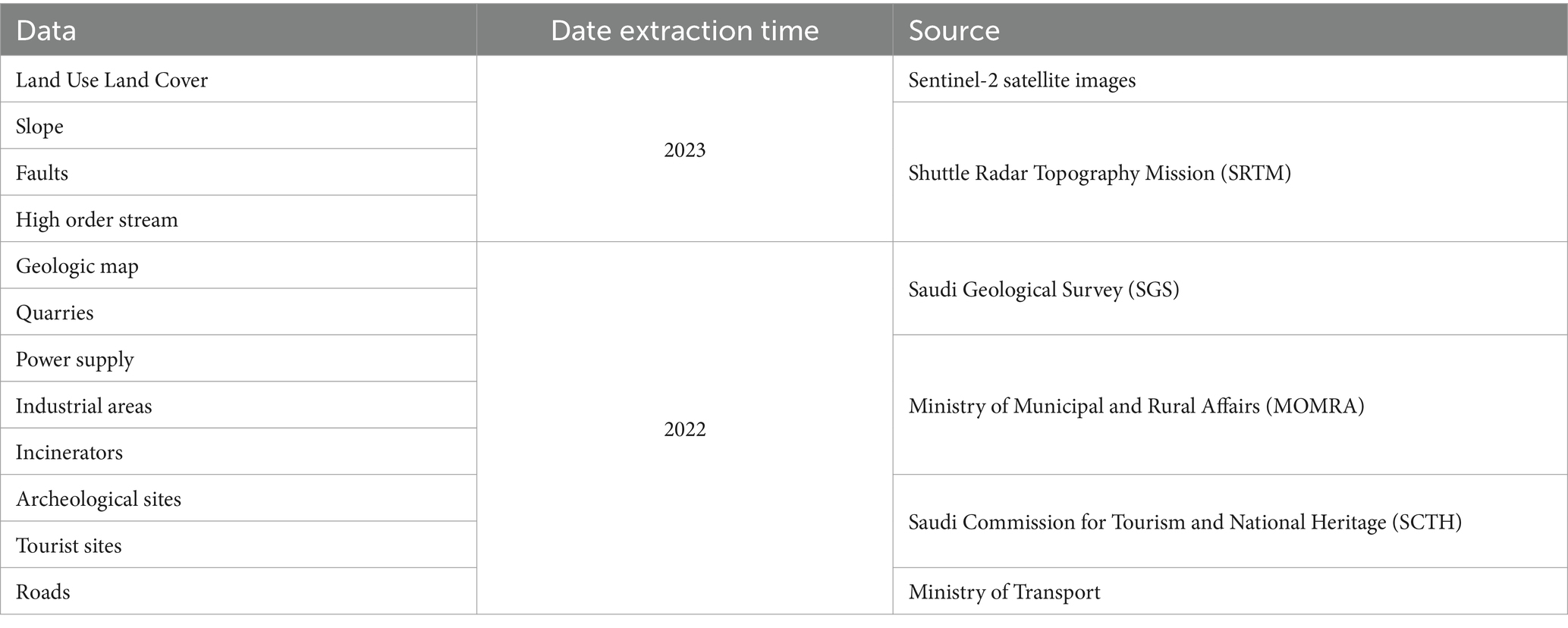
Table 1. Data sources.
This methodological approach, combining advanced satellite imagery with comprehensive topographical data and thematic maps, laid the foundation for a detailed understanding of the NEOM region’s geographical and environmental attributes. It facilitated a nuanced analysis of land use patterns, agricultural potential, urban development areas, and water resources, which are critical for planning and sustainability assessments in the development of NEOM.
Figure 2 presents a diagram illustrating the applied analysis.
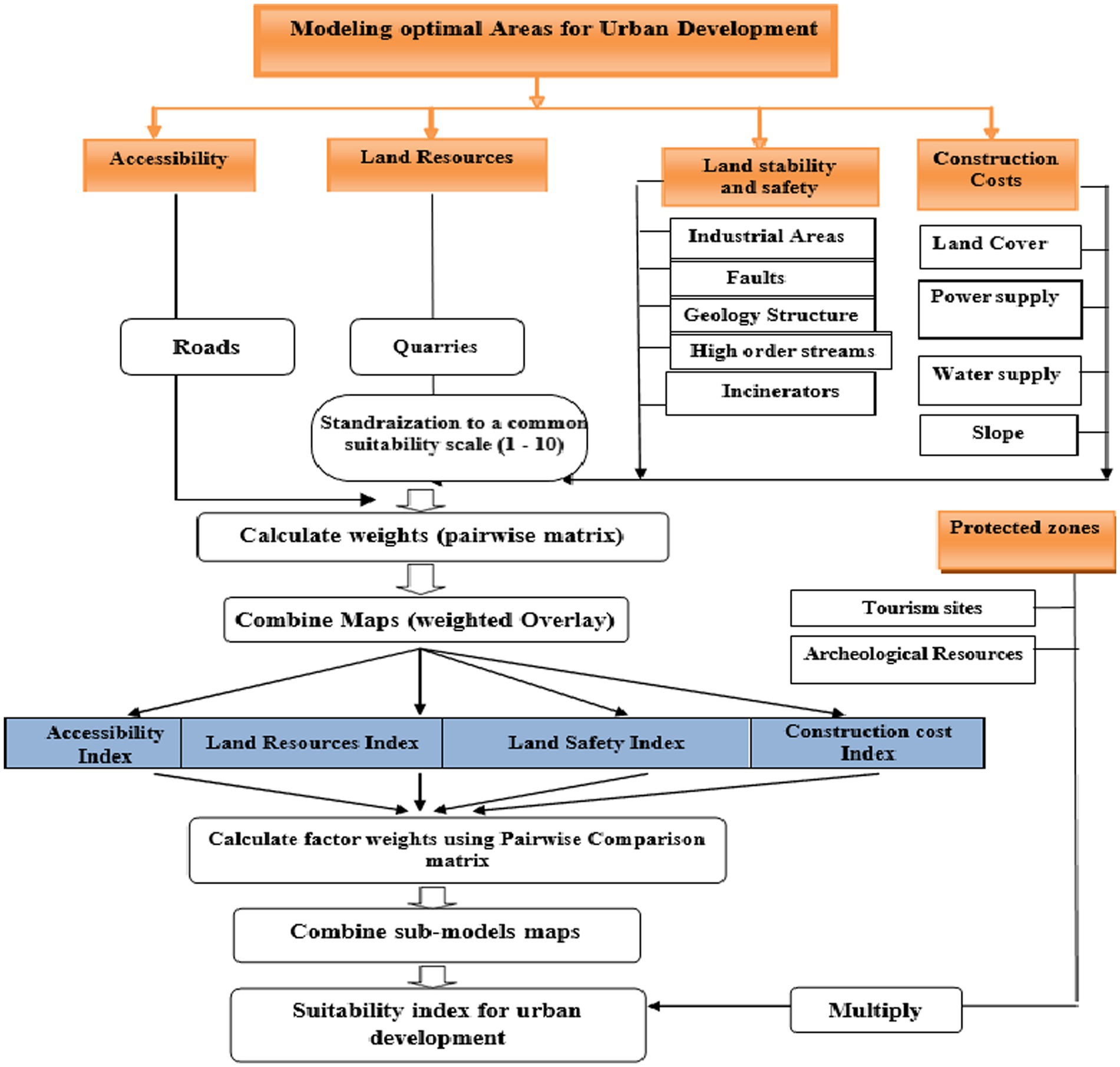
Figure 2. A diagram illustrating the applied analysis.
2.2.1 Defining the criteria
Defining the criteria for site selection is a foundational step in spatial decision-making processes, especially when it comes to urban development, environmental conservation, and land use planning. This task necessitates a deep dive into both scholarly research and expert insights, laying the groundwork for a set of factors and constraints that guide the decision-making process. The selection of specific factors and constraints for determining site suitability is informed by an extensive review of existing literature and consultations with experts in the field (Aminu, 2007; Govindan et al., 2016; Saqr et al., 2021). This dual approach ensures that the criteria are both theoretically sound and practically relevant. Constraints are essential in the criteria framework as they help identify areas that should be excluded from consideration right from the outset. These include regions with sensitive ecosystems, areas already developed, or lands with legal protections. By filtering out unsuitable areas, constraints ensure that the analysis focuses only on viable sites. Factors, in contrast to constraints, are used to assess the suitability of areas based on specific indicators of appropriateness. These are aligned with sustainable development goals and can include a variety of sub-criteria, such as environmental impact, resource availability, and socio-economic benefits (van Herwijnen et al., 1993; Yang et al., 2008). The overarching aim of applying these criteria is to support sustainable development, which encompasses economic viability, environmental preservation, and social equity (Keshkamat et al., 2009). This holistic approach ensures that selected sites contribute positively to long-term societal goals.
2.2.2 Dissecting into components
Given the complexity of overlay analysis, breaking down the process into smaller, thematic sub-models is a recommended strategy. This approach allows for a more organized and focused analysis of each factor, facilitating clearer insights into the interactions between different variables. For this study, factors influencing land suitability for communities were grouped into five main themes:
1. Land resources: Assesses the availability and quality of natural resources, such as water and arable land.
2. Land stability: Considers geological and topographical features to ensure that the land is stable and suitable for construction.
3. Accessibility: Evaluate how easily the area can be reached, considering existing transportation networks and planned infrastructure.
4. Construction costs: Estimates the financial implications of developing on a particular site, including the costs associated with terrain modification and infrastructure development.
5. Land protection: Aims to safeguard areas of historical, archeological, or cultural significance.
Detailed descriptions of these themes used in creating the sub-models will be discussed in the following section:
A. Land resources theme
The primary focus in developing areas should be on utilizing potential land resources as they are essential for creating job opportunities. When modeling the availability of land resources, it is crucial to consider factors. One important factor is the presence of quarries and mines, which are vital for activities. In NEOM, there are mineral resources present, including coal, black sands, glass sand, and kaolin, as well as construction materials, such as marl, dolomite, sand, gravel, marble, and granite. Additionally, there are resources required by the cement industry such as limestone, shale, and gypsum. The Saudi Ministry of Petroleum and Mineral Resources provided the mineral resources map used in this analysis.
A. Land stability theme
In the NEOM project’s site selection for urban development, creating a constraints map is essential for identifying and excluding sensitive and at-risk areas. These constraints are often represented as buffered zones, among other markers, and are integral to sustainable development analysis in NEOM’s planning initiatives. Given the fragile nature of desert ecosystems, it is vital for urban development to minimize environmental impacts, preserving biodiversity and natural resources (Fischer, 2023). This methodology ensures that development is conducted with a high regard for ecological sensitivities, effectively reducing environmental impacts and adhering to sustainability principles by avoiding areas with ecological, geological, or social vulnerabilities. To pinpoint the areas to be excluded from development, we compiled a map highlighting land hazards (as detailed in Table 2). The assessment of land stability was then conducted based on the inverse data from this hazard map, guiding the selection process away from potentially unstable or unsuitable locations.
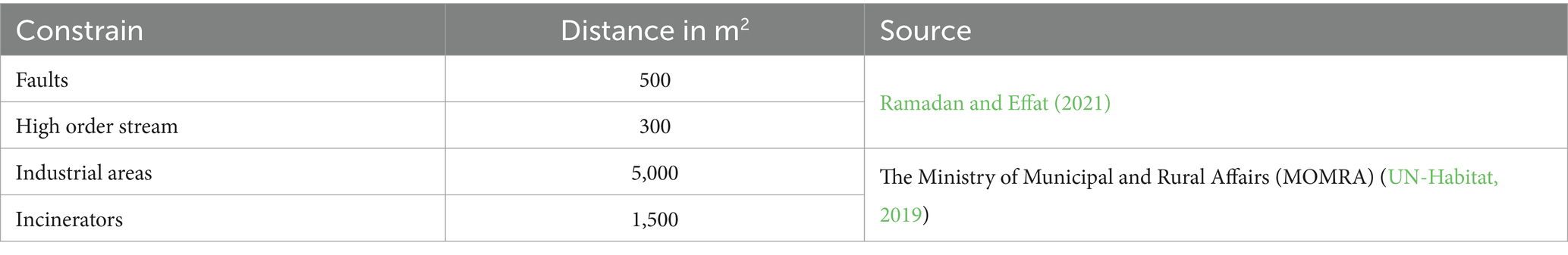
Table 2. Land stability constrains.
The map that showcases land stability is generated by inversely calculating the vulnerability index map, effectively transforming vulnerability scores into stability indicators. This inverse calculation, essentially dividing 1 by the vulnerability score, allows for a nuanced assessment of land stability based on the following several critical factors:
1. Industrial areas and incinerators
This category identifies areas at risk due to pollution from human activities. The Ministry of Municipal and Rural Affairs (MOMRA) plays a crucial role in designating buffer zones around such industrial sites to mitigate their impact. A detailed enumeration of these zones, complemented by insights from existing literature, is presented in Table 2.
1. Fault zones
Regions intersected by fault lines are inherently more prone to land collapse due to the geological instabilities they introduce. Identifying these areas is crucial for assessing land vulnerability.
1. Geological structure
Composition for development varies; stratification helps to distinguish between clayey terrains, which are considered structurally unstable, and rocky terrains, which, while more stable, may lead to increased costs for infrastructure development. This distinction is elaborated upon by Golany (1983), highlighting the importance of geological considerations in urban planning.
1. High order streams
Areas with a dense network of streams are identified as having a heightened risk of land collapse. Stream density serves as an indicator of potential erosion and waterlogging issues, both of which can significantly affect land stability.
By evaluating these factors, the land stability map serves as an essential tool for urban planners and developers, guiding decision-making processes to ensure that development is both safe and sustainable.
A. Accessibility theme
The accessibility theme is pivotal in urban planning, emphasizing the necessity of sound infrastructure and ease of access for the efficient functioning of urban locales. This theme impacts numerous aspects, including transportation, logistics, and the provision of utilities and services. A critical factor in assessing accessibility is the presence and condition of road networks, which facilitate transportation to and from development sites and play a crucial role in linking different areas (Dastgoshade et al., 2024). These connections are essential for catering to residential and commercial needs. Our primary attention was directed toward mapping roads, routes, and tracks traversing desert landscapes. The road data utilized in this analysis was sourced from the Ministry of Transport, with all relevant roads being digitized for this purpose, ensuring a comprehensive understanding of current accessibility and aiding in the strategic planning of future development projects.
A. Construction cost theme
The long-term success of urban development projects hinges significantly on their economic sustainability. This involves considering the development’s initial costs, its potential to generate employment, and its ability to bolster the overall economic growth of the region (Du et al., 2023). When selecting a site, economic feasibility plays a crucial role in influencing decision-making through various cost-related factors. Evaluating these factors thoroughly ensures that site selection for urban development not only meets present-day economic requirements but also aligns with the strategic vision for sustainable economic growth in the region. These include:
1. Land cover/Land use
Urban planning significantly depends on understanding the distribution of land cover and land use, as these elements dictate potential constraints and opportunities for development. Specific areas, including reserves, agricultural lands, and existing urban zones, are typically earmarked to remain unaltered due to their current utilization or designated importance (Borana and Yadav, 2023). The process of generating a land cover layer involves sophisticated classification methods applied to Sentinel 2 satellite imagery. This analysis delineates the landscape into four primary classes: water bodies, vegetated areas, desert regions, and urbanized spaces. Such categorization is instrumental in guiding the decision-making process for urban development, ensuring that planning aligns with the existing natural and human-made environments.
1. Power supply
The closeness to existing power supply infrastructure, such as high-voltage electric lines or power stations, plays a pivotal role in the economic aspects of choosing locations for development. The intense solar radiation characteristic of desert environments offers a valuable opportunity to tap into renewable energy sources (Asakereh et al., 2017). Leveraging this renewable energy potential is key to diminishing dependency on fossil fuels and advancing sustainable development. The mapping of high-voltage lines and power stations was carried out utilizing data extracted from topographic maps, providing essential insights for site selection based on proximity to energy resources.
1. Water supply
In arid areas, such as NEOM, the scarcity of water presents a formidable obstacle to the realization of sustainable urban growth. The presence and accessibility of water resources emerge as critical considerations in the planning of area development (Marinou, 2020; Aklan et al., 2023), vital for meeting the needs of residential, commercial, and agricultural sectors. In addressing this challenge, the prospect of harnessing seawater through desalination has been considered. To evaluate this option, a distance module was applied to assess the closeness to the coastline, thereby gauging the feasibility of integrating seawater desalination into the region’s water supply strategy.
1. Slope
The assessment of slope was conducted using the Shuttle Radar Topography Mission (SRTM) digital elevation model (DEM) within the ESRI ArcGIS 10.3 environment. Sloped terrains are generally more susceptible to issues such as land collapse, making them critical considerations in urban planning and development. For our analysis, areas with slopes exceeding 25 degrees were deemed unsuitable for development (Zhang et al., 2023). This classification criteria helps in identifying and excluding areas where steep terrain could pose significant challenges or hazards to construction and long-term stability.
A. Land protection theme
The Land Protection Theme underscores the archeological significance of the area under study, emphasizing the imperative to preserve historical sites and prevent alterations in land use that could impact their integrity (Alsubeh and Helmi, 2024). To safeguard these areas, including both archeological sites and tourist attractions, data were sourced from the Saudi Commission for Tourism and National Heritage (SCTH). In our methodology, lands were categorized with a specific focus on protection; areas designated as protected received a value of zero, indicating their exclusion from development consideration. Furthermore, a buffer zone extending 500 meters around these sites was also assigned a value of zero, effectively delineating these regions as off-limits for any developmental activities. This approach ensures the conservation of cultural and historical assets while guiding urban planning decisions.
2.2.3 Standardization
To ensure a rigorous analysis, standardizing the measurement scales of the attributes under consideration is paramount. This process involves translating these attributes into a scale that accurately reflects their suitability for the intended analysis or application. Here is how this standardization can be approached, particularly in the context of assessing land use, agricultural viability, urban development potential, or environmental conservation:
1. Rating scale definition: Each attribute across various factors is rated on a scale from 1 to 9, with higher values indicating greater favorability or suitability. This scale allows for a nuanced assessment of each attribute’s contribution to the overall evaluation criteria.
2. Unsuitability coding: Pixels or areas identified as unsuitable based on the predefined criteria are assigned a value of zero. This clear demarcation ensures that these unsuitable regions are easily distinguishable and excluded from further suitability analysis, focusing attention and resources on areas with potential.
3. Attribute standardization process as shown in Table 3:
• Identification of attributes: Initially, all relevant attributes contributing to the analysis are identified. These might include factors such as soil quality, water availability, proximity to urban centers, elevation, and slope for land use and agricultural assessments, or infrastructural and environmental considerations for urban development.
• Quantitative assessment: Each attribute is quantitatively assessed based on its importance or relevance to the overall goal. For example, in agricultural land assessment, soil fertility might be given a higher rating than slope.
• Application of the rating scale: The determined quantitative assessments are then aligned with the 1 to 9 rating scale. Attributes most conducive to the objective receive higher scores, indicating their favorable conditions.
• Integration into analysis: Once all attributes have been rated, these standardized scores are integrated into the broader analysis framework. This might involve spatial analysis, where each pixel in a geographic information system (GIS) is evaluated based on the cumulative scores of its attributes.
1. Use of standardized attributes in decision-making:
• Spatial suitability models: In GIS, standardized attributes can be used to develop spatial suitability models that visually represent the most and least suitable areas for a given purpose.
• Weighted overlay analysis: Attributes can be weighted according to their importance before being overlaid to create a composite suitability map. This approach is particularly useful in complex decision-making scenarios where multiple factors influence the outcome.
1. Final evaluation and mapping: The end product of this standardization and analysis process is a set of maps or models that clearly delineate areas based on their suitability, from highly suitable (rated closer to 9) to unsuitable (rated as zero), as shown in Figure 3. These outputs can guide decision-making in urban planning, environmental conservation, agricultural development, and other applications, ensuring that efforts are focused on areas with the highest potential.
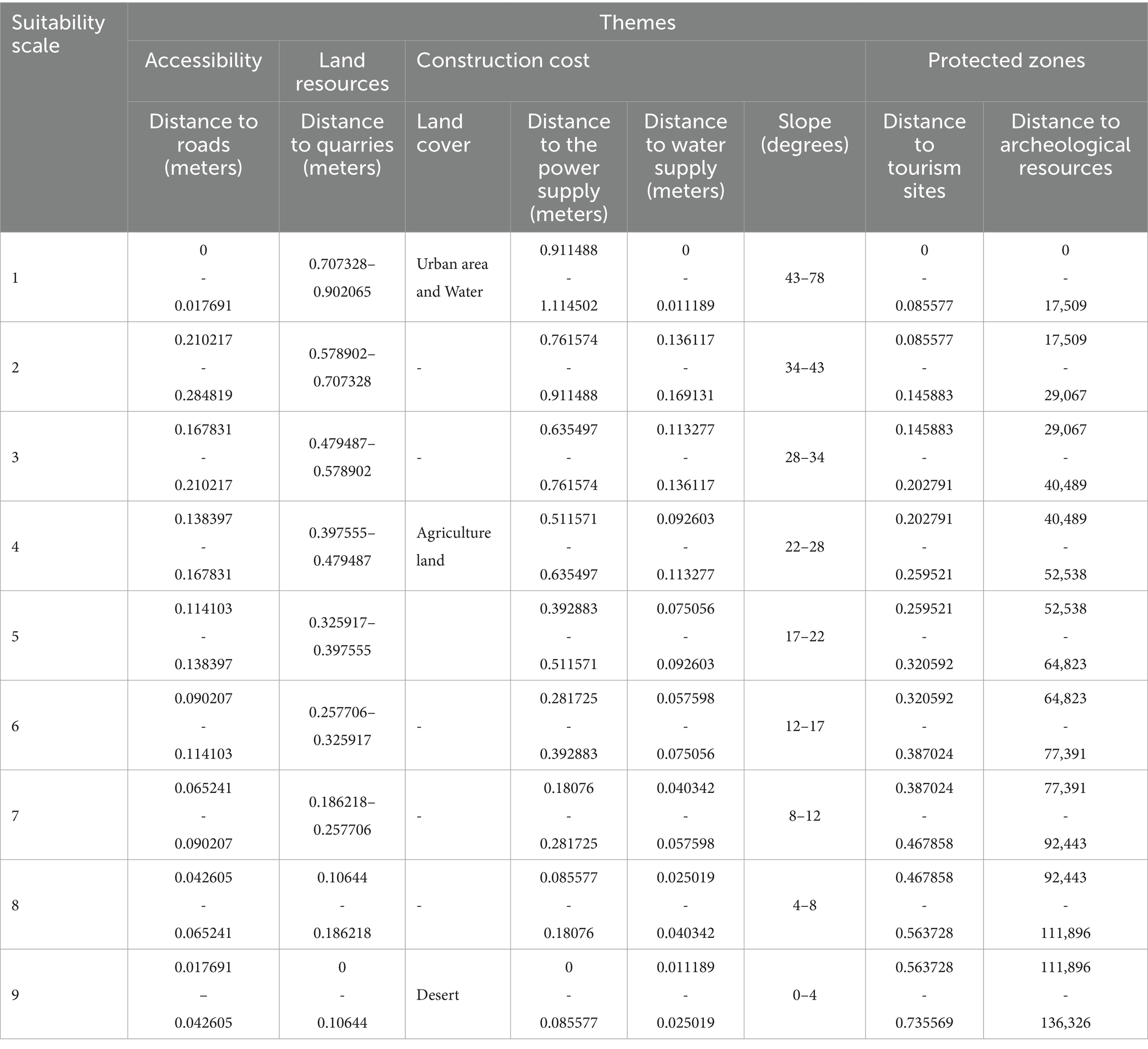
Table 3. Standardization of themes.
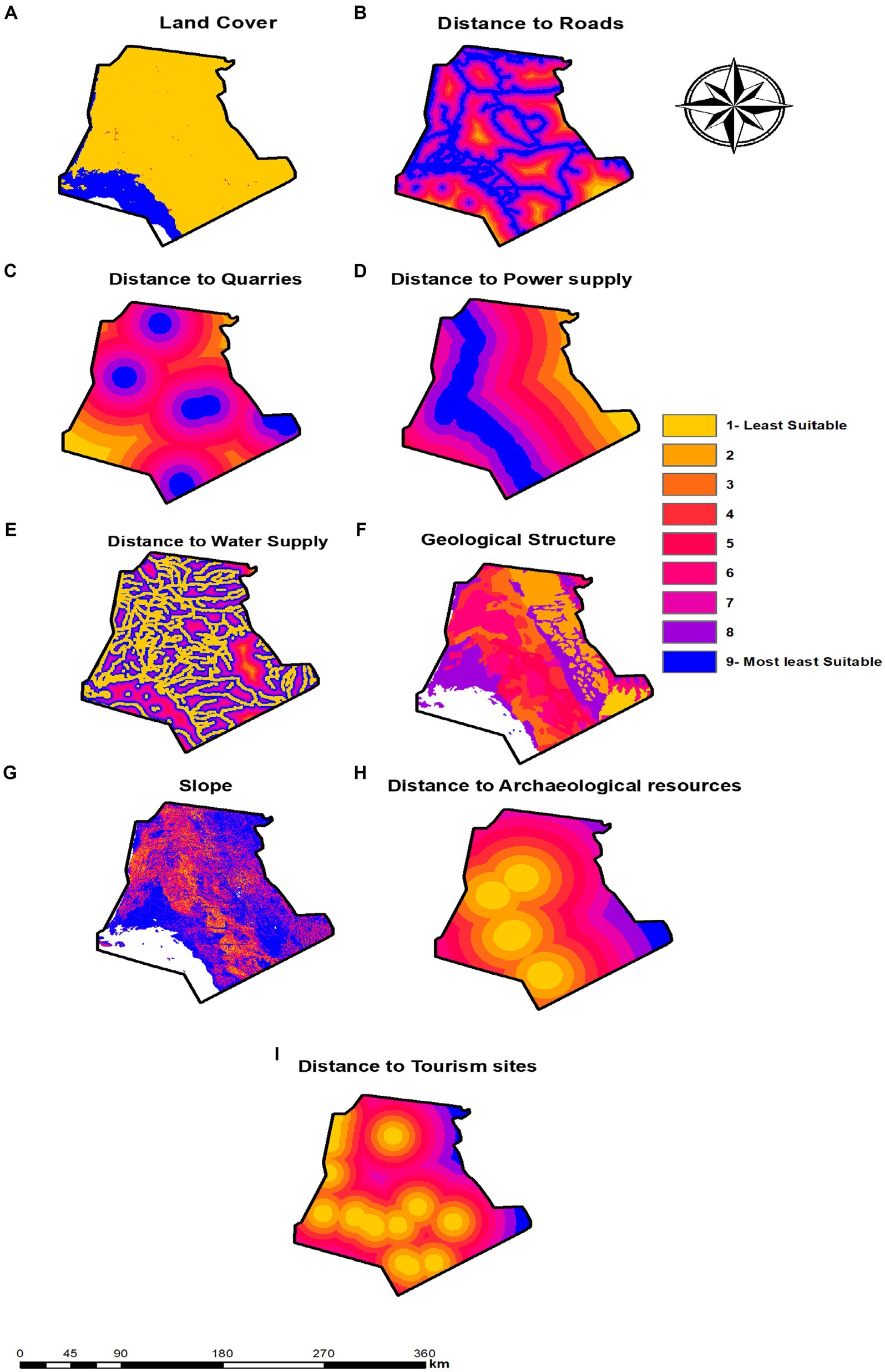
Figure 3. Standardized factors map: (A) Land cover; (B) distance to roads; (C) distance to quarries; (D) distance to the power supply; (E) distance to the water supply; (F) geological structure; (G) slope; (H) distance to archeological resources; (I) distance to tourism sites.
2.2.4 AHP calculation steps developing the hierarchy
To establish the relative importance of various factors in our site selection process for urban development, we implemented the Analytical Hierarchy Process (AHP), as devised by Saaty (Saaty, 1977). This method involves pairwise comparisons of criteria within a structured matrix, the dimensions of which correspond to the number of criteria being evaluated. By creating a comparison matrix and conducting an in-depth assessment of criteria pairs, we calculated a priority vector (Wj) that reflects the relative weights of these factors, ensuring our evaluations were consistent (Sharma et al., 2022). The scaling for these comparisons was conducted on a 1 to 9 scale, as shown in Table 4.
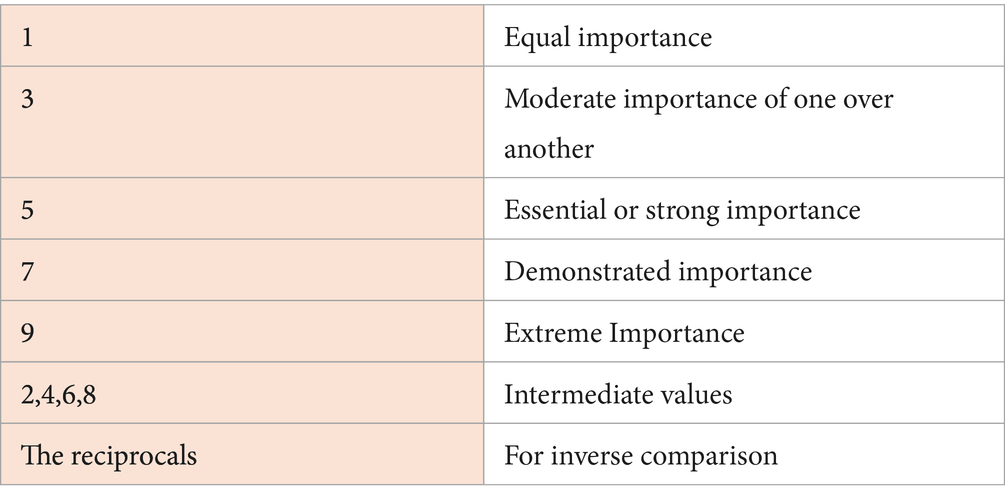
Table 4. Pairwise comparison matrix (Saaty, 1977).
As recommended by Bailey (2005), through comprehensive, extensive literature reviews. These reviews informed the creation of a pairwise comparison matrix, as illustrated in Table 5, where weights are denoted as “aij.” For example, a comparative weight of a23 = 3 indicates the third attribute is three times as important as the second, with its reciprocal a32 = 1/3 representing the inverse relation. This matrix’s values are normalized by dividing each judgment by the sum of its column, leading to the derivation of the priority vector by averaging these normalized values across each row. This vector is then normalized further to achieve a representation of all factor weights (Wj). The next steps involved the following:
1. Computing the weighted sum vector by multiplying the comparison matrix with the priority vector, normalizing each resulting value, and then summarizing these to obtain an overall weighted sum.
1. Determining the consistency vector and calculating both lambda (λ) and the consistency index (CI) to measure the coherence of our pairwise comparisons. Lambda is the sum of the consistency vector’s components, serving as a benchmark for consistency, where perfect consistency results in λ equaling the number of criteria, n.
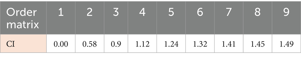
Table 5. CI index (Saaty, 1977).
The CI provides a normalized measure of inconsistency, which is crucial for evaluating the reliability of our assessments (Saaty, 1994). Table 5 presents the CI values based on the matrix order.
To synthesize the data effectively in our overlay analysis, it is essential to interlink all input factors, pinpointing locations that best meet our model’s goals. A weighted summation method allows us to evaluate which areas are more favorable for development according to the generated output raster. We developed a suitability index for different zones by applying a weighted overlay approach, which integrates the maps of various criteria. In this process, each factor (j) is assigned a specific weight (Wj), and scores (Xij) are allocated to gauge their relevance. Moreover, we incorporated Πcl, a map representing symbols, to enrich our analysis, ensuring a comprehensive assessment of all variables involved in determining the most suitable locations for development.
The factor weights are derived using the Analytical Hierarchy Process (AHP) as represented in (Tables 6–9).
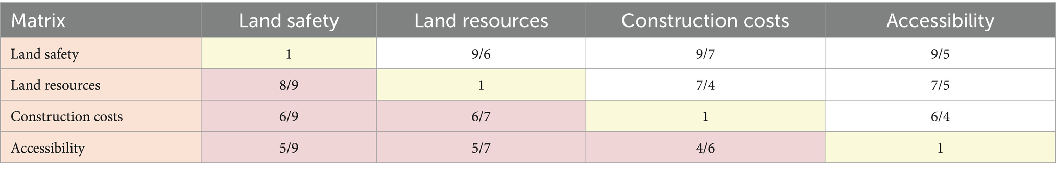
Table 6. Pairwise comparison.
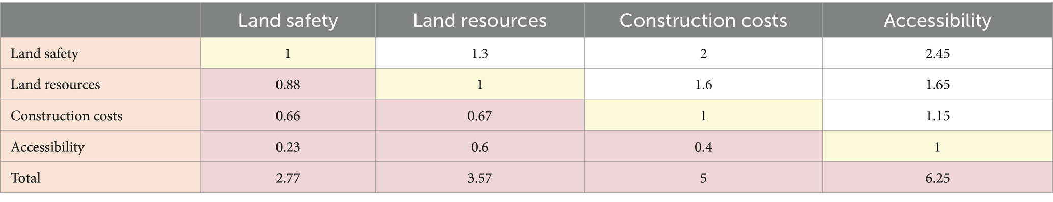
Table 7. Normalized pairwise comparison matrix and computation of weights.
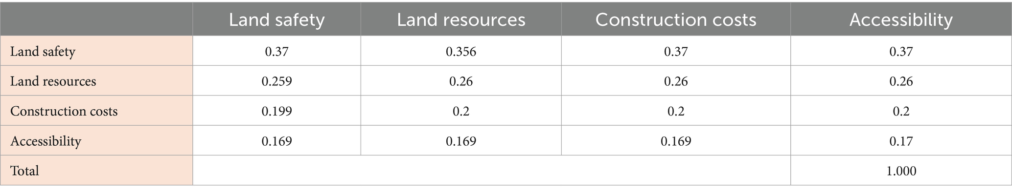
Table 8. Normalized pairwise comparison matrix and calculated weights.
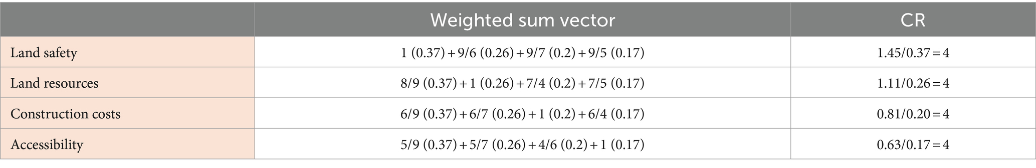
Table 9. Calculation of the consistency ratio (CR).
2.2.5 Model development for each theme
For each thematic area, a detailed model is developed that accounts for the specific attributes and layers relevant to that theme. This involves selecting appropriate indicators, assigning weights based on their importance, and integrating them into a cohesive analytical framework using tools such as ESRI Spatial Analyst. The multi-criteria evaluation model Equation (1) was used to determine the five themes of sub-models, as shown in Figures 4, 5, which illustrates the sub-model specifically related to the land stability theme (constraints).
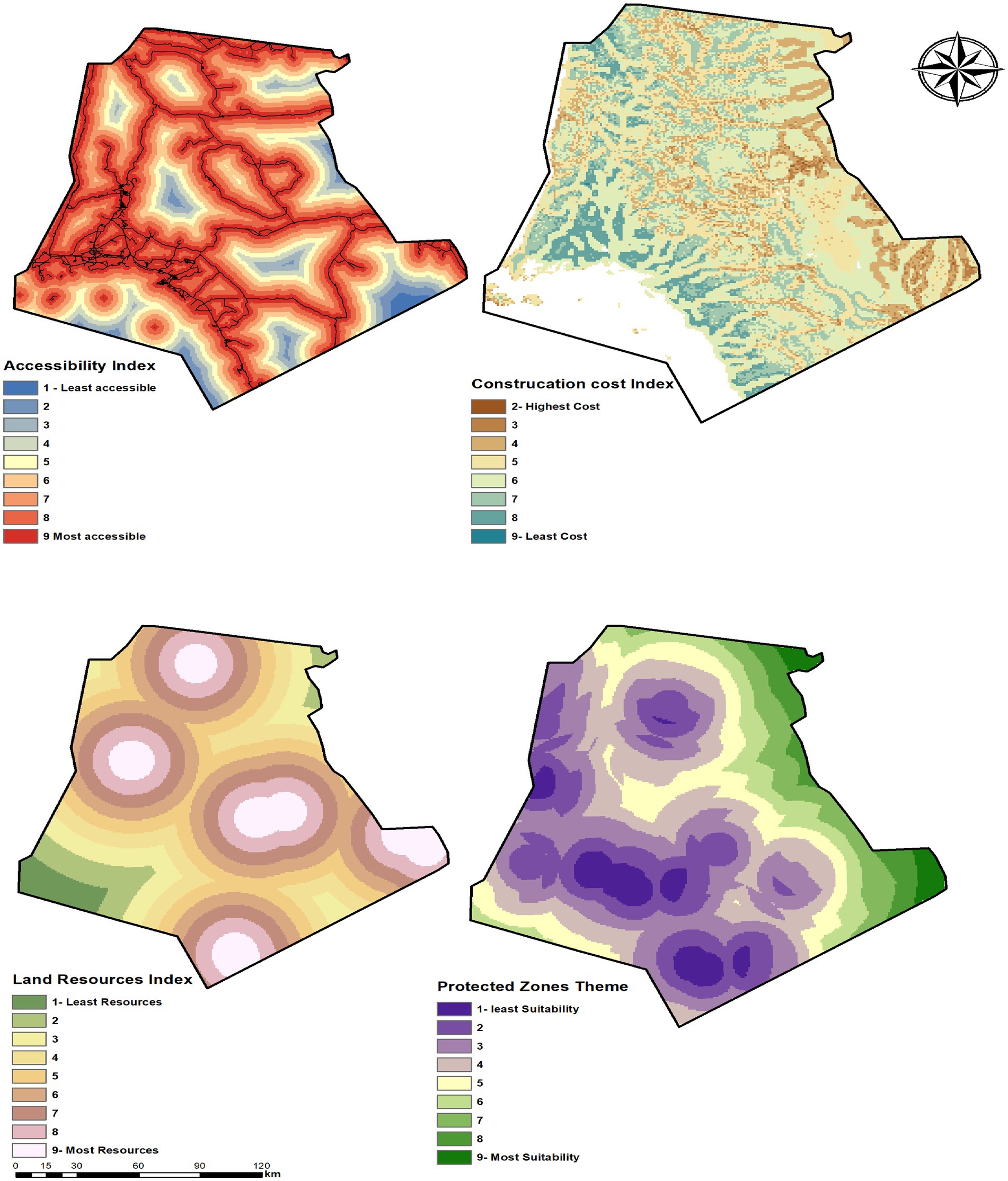
Figure 4. Themes sub-models maps.
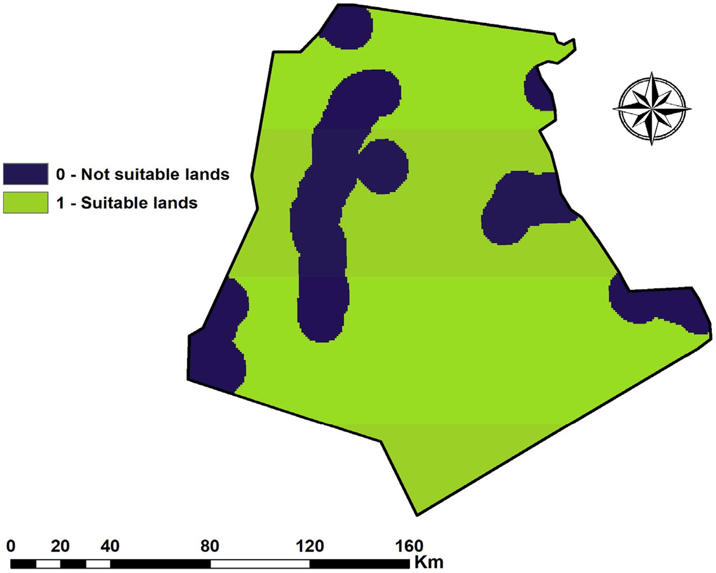
Figure 5. The land stability theme.
2.2.6 Integration toward Overlay Model’s objective
Although each sub-model addresses a specific aspect of site suitability, their integration is crucial for achieving the overall objective of the overlay analysis. This collaborative approach ensures that the final site selection supports safety, resource optimization, cost-efficiency, accessibility, and the preservation of cultural and natural values, as shown in Figure 6.
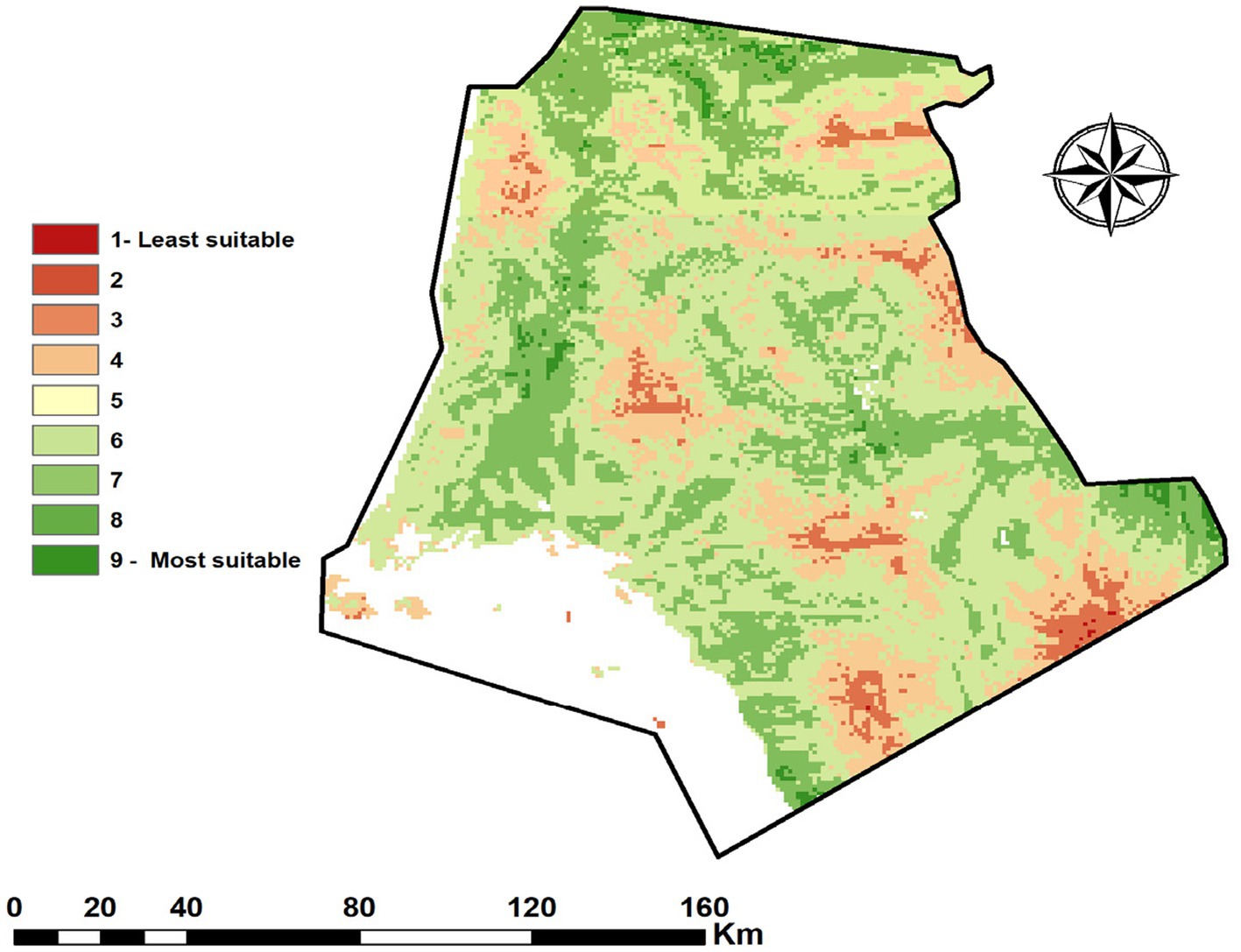
Figure 6. Final weighted linear combination between themes.
3 Results and discussion
3.1 Integrating development with infrastructure and natural surroundings
The extensive spatial analysis, supported by calculated results, spans 6312.33 square kilometers or accounts for 28.23% of the entire study area. These insights, elaborated in Table 10 and depicted in Figure 7, highlight the crucial role these zones play in achieving the NEOM project’s ambitious urban development objectives.
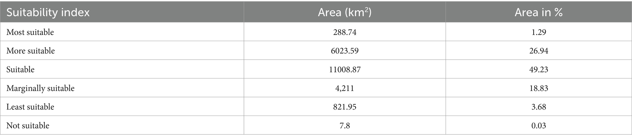
Table 10. Suitability categories areas in Km2.
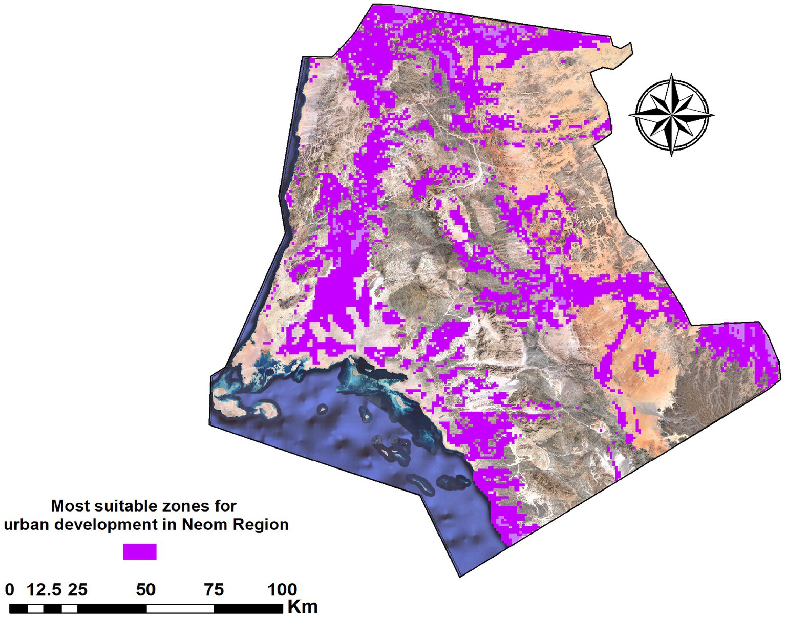
Figure 7. Most suitable zones for urban development in the NEOM region.
This analysis underscores the advantageous positioning of suitable areas close to current and forthcoming infrastructure developments. Their nearness to the anticipated NEOM airport and planned high-speed rail links enhances their viability for both commercial and residential projects, positioning them as future vibrant urban locales. In addition, the selected zones are primed for development, benefiting from easy access to vital utilities and renewable energy sources. Their proximity to existing and future solar energy projects underscores NEOM’s commitment to eco-friendly energy solutions, promoting immediate development endeavors with a minimal ecological footprint. Otherwise, the spatial analysis uncovers a beneficial connection between these suitable zones and the economic, industrial, and technological sectors within NEOM. This congruence is expected to spur economic enrichment, employment opportunities, and innovation, propelling NEOM toward its aspirational goals.
3.2 Sustainable development in harmony with nature
The chosen areas boast a favorable landscape and are situated near vital water sources, including underground aquifers and prospective desalination sites along the coast. This deliberate selection fosters sustainable water usage practices, which are essential for the region’s flourishing. Situated near protected lands and ecological hotspots, the high-suitability areas are planned with environmental preservation in mind, incorporating buffer zones and green corridors to ensure the ecological integrity of NEOM is maintained amidst development. The analysis integrates microclimatic conditions, selecting areas that naturally support passive cooling, adequate ventilation, and solar energy harvesting. This climate-aware planning demonstrates a forward-thinking approach to crafting sustainable and comfortable urban spaces within NEOM.
The detailed spatial analysis provides a compelling overview of NEOM’s potential to champion sustainable urban development. The strategically chosen zones, recognized for their ideal locations and compatibility with the surrounding coastal and Piedmont landscapes, reflect the meticulous planning underpinning NEOM’s development approach. These areas not only fulfill the criteria set across various thematic evaluations but also represent a thoughtful integration of development initiatives with environmental stewardship and cultural heritage preservation. By steering clear of culturally and historically significant sites and utilizing the region’s distinct natural resources, the identified zones exemplify NEOM’s ability to juxtapose urban growth with the conservation of heritage. This strategy ensures that NEOM’s evolution contributes positively to economic and social goals while honoring and enriching the natural and cultural fabric of the region for future generations.
3.3 Comparison with NEOM’s strategic plans
NEOM’s development vision showcases an ambitious blend of futuristic urban, industrial, and recreational endeavors across approximately 26,500 square kilometers. The NEOM’s initiatives reflect dedication to sustainability, pioneering innovation, and leveraging technology for development, emphasizing renewable energy, water conservation, and advanced digital infrastructures. Its key initiatives, as shown in Figure 8, include:
1. The line: A revolutionary linear city extending over 170 kilometers, aiming to support a million residents in an environment that prioritizes minimal ecological footprint, enhancing walkability, and embedding essential amenities and greenery within a 5-min walk from homes (Yusuf and Abdulmohsen, 2022).
2. Oxagon: Set to become the largest floating industrial complex globally, Oxagon is positioned in NEOM’s southwestern area, focusing on cutting-edge manufacturing, innovation, and technology sectors (Belaïd et al., 2023).
3. TROJENA: An all-season mountain retreat designed for outdoor adventures, including skiing, setting its sights on becoming an international hub for sports and leisure (Analytica, 2022).
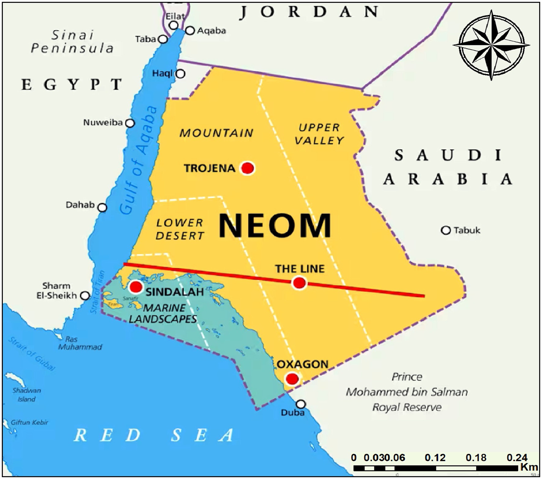
Figure 8. NEOM’s strategic plans.
The congruence between the model’s outputs with NEOM’s Strategic Plansas, shown in Figure 9 confirmed the following:
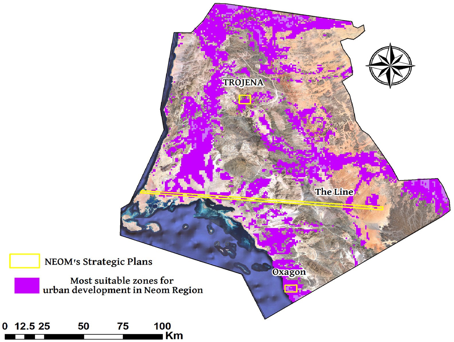
Figure 9. Comparison of final model results with the NEOM’s strategic plans.
Our suitability analysis corroborates “The Line”’s envisioned location, underscoring its viability for urban development. This validation is based on its access, terrain advantages, and the integration possibilities for renewable energy and sustainable water management, affirming the project’s strategic siting and objectives. Although the model identifies the “Oxagon” coastal regions as fitting, given their access to water and transport networks, it also brings to attention the environmental sensitivities of marine ecosystems potentially overlooked in the preliminary plans. This gap underscores the necessity for in-depth environmental evaluations to ascertain the project’s sustainability credentials. The model supports “TROJENA”‘s development, pinpointing mountainous areas as apt for leisure and tourism projects. Their distinctive climate and topography, coupled with the potential to offer a unique visitor experience, endorse the project’s placement and concept.
The congruence between the model’s outputs and NEOM’s development blueprint affirms the model’s applicability as an effective tool in earmarking zones suitable for varied development pursuits, enhancing its value in strategic urban planning. Environmental and sustainability highlights: The model’s indication of potential environmental challenges, especially with “Oxagon,” emphasizes its role in surfacing environmental considerations that might require further assessment, ensuring that development adheres to sustainability and ecological preservation standards.
This analytical comparison offers insights for refining NEOM’s land use and development strategies, advocating for a balanced approach that marries innovation with environmental conservation and points out areas where development synergizes with sustainability goals alongside zones where ecological protection should take precedence.
The juxtaposition of the GIS-based suitability model’s insights with NEOM’s planned projects presents a nuanced perspective on the region’s development prospects. It validates the strategic foresight behind NEOM’s planning decisions while highlighting areas where enhanced focus on environmental sustainability could augment the overarching development strategy. This balanced methodology ensures NEOM’s ambition to fuse technological advancement with environmental guardianship and sustainability ethos, paving the way for a future where development and nature coexist harmoniously.
3.4 The socio-economic and environmental implications of suitable and unsuitable areas for future development
3.4.1 Implications of identifying suitable areas
3.4.1.1 Socio-economic impacts
• Economic growth and diversification: The identification of suitable areas paves the way for targeted investments in infrastructure, renewable energy, technology hubs, and tourism, contributing to the region’s economic growth and diversification. It opens up new job opportunities and stimulates local economies by attracting international businesses and researchers.
• Community development and social wellbeing: Developing these areas with a focus on sustainability and inclusivity can lead to the creation of new communities that offer improved living conditions, access to services, and social cohesion. The emphasis on smart city elements such as digital connectivity can enhance education, healthcare, and overall quality of life for residents.
3.4.1.2 Environmental impacts
• Conservation and sustainable use of resources: Suitable areas for development were selected partly because of their potential to support sustainable resource use. This means development projects in these areas are more likely to incorporate renewable energy, water conservation techniques, and sustainable waste management, minimizing the environmental footprint.
• Biodiversity protection and restoration: By focusing development in suitable areas, other regions can be preserved or earmarked for conservation projects, protecting biodiversity and natural landscapes. This strategic approach ensures that urban expansion contributes to ecological balance and resilience against climate change.
3.4.2 Implications of identifying unsuitable areas
3.4.2.1 Socio-economic impacts
• Guiding strategic land use planning: Recognizing areas as unsuitable for development helps in directing resources and planning efforts toward regions with higher potential for sustainable growth. This strategic land use planning can prevent investments in areas where development could lead to socio-economic disadvantages, such as isolated regions lacking access to essential services or markets.
• Risk mitigation: Identifying unsuitable areas also plays a crucial role in mitigating risks associated with urban development, including those related to environmental hazards, water scarcity, or infrastructural challenges. This foresight helps in avoiding the socio-economic costs of developing in areas prone to these risks.
3.4.2.2 Environmental impacts
Preservation of natural habitats: Unsuitable areas often include regions critical for biodiversity, ecological services, or natural beauty. Recognizing these areas as unsuitable for development is a proactive measure to preserve natural habitats, ensuring the maintenance of ecosystem services and the protection of wildlife.
Climate change adaptation: Some areas may be deemed unsuitable due to vulnerabilities to climate change impacts, such as flooding, desertification, or sea-level rise. Keeping these areas free from development not only protects the environment but also aligns with broader strategies for climate change adaptation, reducing long-term socio-economic vulnerabilities.
The identification of suitable and unsuitable areas for future development in the NEOM region carries significant implications for socio-economic growth, environmental conservation, and the strategic planning of sustainable urban spaces. By carefully considering these implications, planners and policymakers can ensure that development within NEOM not only contributes to the region’s ambition to be a hub for innovation and sustainability but also aligns with global goals for sustainable development and climate resilience. This approach emphasizes the need for an integrated planning strategy that balances development aspirations with the imperative to protect and preserve the natural environment and ensure socio-economic wellbeing for current and future generations.
3.5 Exploring sustainable alternatives in development-limited zones
• Safeguarding biodiversity: Regions marked as development-restricted frequently harbor distinct species and ecosystems, serving as crucial spots for biodiversity. Setting these locales aside for preservation aids in protecting native species and sustaining ecological equilibrium, which is vital for worldwide biodiversity objectives.
• Carbon absorption areas: Lands rich in greenery, particularly those classified as sensitive and unfit for development, can act as natural carbon absorbers. Preserving or even expanding these areas can play a significant role in counteracting climate change.
• Conservation of heritage sites: Identifying zones as unfit for construction due to archeological or cultural significance allows for their preservation as sites of heritage. This safeguards historical narratives while providing educational and tourism opportunities that highlight the area’s cultural wealth.
• Wildlife sanctuaries and recreational parks: Development-restricted zones, especially those with exceptional landscapes or biodiversity, can be transformed into wildlife sanctuaries or parks. These areas offer leisure activities for both locals and tourists, encourage nature-based tourism, and promote awareness of environmental preservation.
• Eco-adventurous and nature-centric tourism: Terrain and ecosystems that are unsuitable for urban development can become hubs for eco-adventurous activities (e.g., trekking and rock climbing) or nature-centric tourism, aligning with NEOM’s ambition to establish a new tourism frontier.
• Environmental research bases: Areas set aside for conservation could house bases for research on desert ecosystems, sustainable resource use, or global warming, potentially positioning NEOM as a leader in environmental and sustainability studies.
• Solar and wind energy projects: Some regions might be unfit for housing or commercial ventures due to their isolation or landscape but ideal for renewable energy initiatives such as solar or wind farms, supporting NEOM’s renewable energy ambitions.
3.5.1 Conservation strategies
To guarantee the preservation and appropriate use of zones designated as unfit for development, the following conservation strategies should be adopted:
• Legislative safeguards: Implementing legal measures to protect sensitive zones from development, thus conserving their ecological and cultural integrity.
• Eco-friendly management approaches: Crafting management strategies for the preserved areas that encompass eco-friendly tourism, regulated entry, and ecosystem restoration efforts to ensure their enduring preservation.
• Community involvement and awareness: Engaging local populations in the conservation process and enhancing awareness regarding the significance of safeguarding natural and cultural heritage to cultivate a shared sense of environmental guardianship.
The categorization of certain areas within the NEOM project as development-restricted is not a limitation but a strategic avenue to foster the project’s objectives of sustainability, conservation, and recreation. By thoughtfully designating alternative functions for these areas, NEOM can fulfill its vision of being a beacon of innovation, all while respecting and conserving the natural and cultural environment. This approach highlights NEOM’s dedication to forging a model for future cities that balances development with ecological and societal sustainability.
4 Limitations of the GIS-based model and AHP methodology
The GIS-based model and analytical hierarchy process (AHP) methodology, while instrumental in evaluating land suitability for urban development in regions like NEOM, come with inherent limitations that must be considered.
4.1 GIS-based model limitations
• Dependence on data quality and availability: A critical constraint of the GIS-based approach is its reliance on the quality, resolution, and timeliness of spatial data. Inaccuracies or lack of up-to-date information can lead to misrepresentation of current conditions, impacting the precision of suitability assessments.
• Static data analysis: The model’s reliance on static snapshots for analysis does not adequately capture the dynamic nature of environmental and socio-economic changes, which can significantly influence the long-term suitability of development areas.
4.2 AHP methodology limitations
• Assumption of criterion independence: AHP’s foundational assumption that evaluative criteria are independent and may not align with the interconnected realities of urban development, where criteria can be deeply interrelated, affecting the robustness of the decision-making process.
• Challenges with multiple criteria: The method becomes increasingly cumbersome and less intuitive as the number of criteria grows, complicating the evaluation process and potentially hindering accurate priority setting among diverse development objectives.
Future research could benefit from integrating dynamic modeling techniques to better reflect the evolving nature of target environments and employing advanced multi-criteria decision-making frameworks capable of addressing the interdependencies among evaluative criteria. Recognizing these limitations is crucial for refining the GIS-based and AHP methodologies, ensuring they more accurately reflect the complexities of urban development planning. This acknowledgment not only enhances the credibility of the current study but also lays the groundwork for more sophisticated approaches to sustainable urban development in the future.
5 Conclusion
This research delves into a detailed spatial analysis and evaluation of suitability for the NEOM region in Saudi Arabia, showcasing significant insights and pioneering strategies for urban development within the challenging desert landscapes. Utilizing GIS and AHP techniques, the study identifies crucial areas within NEOM that are most promising for sustainable urban growth, highlighting zones that excel in terms of land resources, stability, accessibility, construction costs, and conservation needs.
Our findings spotlight areas with the highest suitability scores, notably those with grid values of 9 and 8, spanning 6312.33 square kilometers or 28.23% of the examined area. These strategically located zones, which align with NEOM’s vision, are deemed ideal for the development of future urban centers. Their close proximity to planned infrastructure, such as transportation routes and renewable energy projects, along with their natural attributes and dedication to preserving cultural and ecological landmarks, highlight NEOM’s capability to accommodate innovative development initiatives in sync with its desert context.
However, it is important to recognize certain limitations of this research, including the reliance on static data and pre-existing datasets, which may not fully reflect the dynamic environmental and socio-economic factors at play in the NEOM region. Although the GIS-based model and AHP methodology offer a solid analytical foundation, assumptions regarding the independence of criteria and the complexity of managing various criteria could impact the depth of understanding concerning urban development suitability.
Looking forward, addressing these limitations presents opportunities for future research. Incorporating real-time data collection and dynamic modeling could improve the precision and applicability of suitability evaluations over time. Broadening the scope to encompass extensive socio-cultural impact studies would help ensure that development strategies are considerate and representative of the needs and heritage of the local community. Additionally, adopting flexible planning approaches that consider environmental, economic, and social fluctuations may pave the way for more resilient and sustainable development trajectories for NEOM and similar initiatives globally.
This study marks an important advancement in comprehending the intricacies of urban development in desert areas, offering a systematic method for pinpointing suitable locations for such projects within the NEOM region. By underscoring the project’s potential and addressing its challenges, our research contributes valuable perspectives to urban planning and sustainable development disciplines. As NEOM progresses, it is poised to become an exemplar for future cities, merging innovation, sustainability, and cultural conservation to foster vibrant, durable communities in tune with their environmental settings.
Data availability statement
The original contributions presented in the study are included in the article/supplementary material, further inquiries can be directed to the corresponding author.
Author contributions
HA: Conceptualization, Funding acquisition, Investigation, Software, Writing – review & editing. AK: Data curation, Methodology, Supervision, Writing – original draft. IA: Formal analysis, Funding acquisition, Project administration, Writing – original draft. MR: Conceptualization, Data curation, Formal analysis, Funding acquisition, Investigation, Methodology, Project administration, Resources, Software, Supervision, Validation, Visualization, Writing – original draft, Writing – review & editing. RR: Project administration, Validation, Writing – original draft. AZ: Resources, Visualization, Writing – original draft.
Funding
The author(s) declare that financial support was received for the research, authorship, and/or publication of this article. This research was funded by the Deanship of Scientific Research, Princess Nourah bint Abdulrahman University, through the funding program for targeted research number (PNU-Targeted-I).
Conflict of interest
The authors declare that the research was conducted in the absence of any commercial or financial relationships that could be construed as a potential conflict of interest.
Publisher’s note
All claims expressed in this article are solely those of the authors and do not necessarily represent those of their affiliated organizations, or those of the publisher, the editors and the reviewers. Any product that may be evaluated in this article, or claim that may be made by its manufacturer, is not guaranteed or endorsed by the publisher.
References
AbdelRahman, M. A., Natarajan, A., and Hegde, R. (2016). Assessment of land suitability and capability by integrating remote sensing and GIS for agriculture in Chamarajanagar district, Karnataka, India. Egypt. J. Remote Sens. Space Sci. 19, 125–141. doi: 10.1016/j.ejrs.2016.02.001
Abdullahi, S., Pradhan, B., Mansor, S., and Shariff, A. R. M. (2015). GIS-based modeling for the spatial measurement and evaluation of mixed land use development for a compact city. GIScience Remote Sensing 52, 18–39. doi: 10.1080/15481603.2014.993854
Abusaada, H., Elshater, A., and Rashed, R. (2023). Exploring the singularity of smart cities in the new administrative Capital City, Egypt. Ain Shams Eng. J. 14:102087. doi: 10.1016/j.asej.2022.102087
Aina, Y. A. (2017). Achieving smart sustainable cities with GeoICT support: the Saudi evolving smart cities. Cities 71, 49–58. doi: 10.1016/j.cities.2017.07.007
Aklan, M., Al-Komaim, M., and De Fraiture, C. (2023). Site suitability analysis of indigenous rainwater harvesting systems in arid and data-poor environments: a case study of Sana’a basin, Yemen. Environ. Dev. Sustain. 25, 8319–8342. doi: 10.1007/s10668-022-02402-7
Alkhalidi, A., Qoaider, L., Khashman, A., Al-Alami, A. R., and Jiryes, S. (2018). Energy and water as indicators for sustainable city site selection and design in Jordan using smart grid. Sustain. Cities Soc. 37, 125–132. doi: 10.1016/j.scs.2017.10.037
Alshammari, T. (2019). Sustainable urbanisation in desert cities: Case study. Riyadh: University of Sheffield.
Alsubeh, M. A., and Helmi, M. R. (2024). Examining the sustainable impact of urban expansion and urban expansion policies on archaeological sites: evidence from Jordan and Saudi Arabia. Int. J. Low Carbon Technol. 19, 603–612. doi: 10.1093/ijlct/ctae020
Aminu, M. (2007). A geographic information system (GIS) and multi-criteria analysis for sustainable tourism planning. Johor Bahru: Universiti Teknologi Malaysia.
Amr, A. I. (2023). Towards a more sustainable use of urban water for the residential urban landscapes of Egypt’s new desert cities.
Analytica, O. (2022). NEOM is a key part of Saudi Arabia’s green rebranding. Emerald Expert. doi: 10.1108/OXAN-DB268098
Anusha, B., Babu, K. R., Kumar, B. P., Sree, P. P., Veeraswamy, G., Swarnapriya, C., et al. (2023). Integrated studies for land suitability analysis towards sustainable agricultural development in semi-arid regions of AP, India. Geosyst. Geoenviron. 2:100131. doi: 10.1016/j.geogeo.2022.100131
Arabia, S. (2016). General Authority for Statistics (The General Population and Housing Census). Np, nd Web.
Asakereh, A., Soleymani, M., and Sheikhdavoodi, M. J. (2017). A GIS-based fuzzy-AHP method for the evaluation of solar farms locations: case study in Khuzestan province, Iran. Sol. Energy 155, 342–353. doi: 10.1016/j.solener.2017.05.075
Bailey, D. T. (2005). Development of an optimal spatial decision-making system using approximate reasoning. Brisbane: Queensland University of Technology.
Batool, S., Mahmood, S., and Muhammad Ali, M. (2023). Assessment of land suitability and capability by integrating remote sensing and GIS for agriculture in POTWAR region PAKISTAN. Int. Arch. Photogramm. Remote. Sens. Spat. Inf. Sci., 409–415. doi: 10.5194/isprs-archives-XLVIII-M-1-2023-409-2023
Belaïd, F., Amine, R., and Massie, C. (2023). “Smart cities initiatives and perspectives in the MENA region and Saudi Arabia” in Smart cities: Social and environmental challenges and opportunities for local authorities (Cham: Springer International Publishing), 295–313.
Boelt, W. (2014). UN general Assembly’s open working group proposes sustainable development goals. UN Dep. Public Inf :2.
Borana, S., and Yadav, S. (2023). “Urban land-use susceptibility and sustainability—case study” in Water, land, and Forest susceptibility and sustainability (Amsterdam: Elsevier), 261–286.
Bourbonnais, M. (2022). “Applications of geographic information systems, spatial analysis, and remote sensing in environmental impact assessment” in Routledge handbook of environmental impact assessment (London: Routledge), 201–220.
Brown, D. F. (2006). Back to basics: the influence of sustainable development on urban planning with special reference to Montreal. Canad. J. Urban Res. 15, 99–117.
Dastgoshade, S., Hosseini-Nasab, H., and Mehrjerdi, Y. Z. (2024). Investigating of transportation systems development for urban districts, costs and social equity: a case of Sanandaj, Kurdistan. Opsearch 61, 373–398. doi: 10.1007/s12597-023-00697-2
Du, H. S., Colovic, A., and Williams, C. (2023). Guest editorial: FDI and cities: city location attractiveness for FDI, the dynamics and co-evolution of FDI and urban development. Competit. Rev. 33, 505–511. doi: 10.1108/CR-03-2023-192
Effat, H. A., Ramadan, M. S., and Ramadan, R. H. (2022). A spatial model for assessment of urban vulnerability in the light of the UN new urban agenda guidelines: case study of Assiut City, Egypt. Model. Earth Syst. Environ. 8, 3687–3706. doi: 10.1007/s40808-021-01281-7
Fischer, T. B. (2023). Strategic environmental assessment in transport and land use planning. London: Routledge.
González-Méndez, M., Olaya, C., Fasolino, I., Grimaldi, M., and Obregón, N. (2021). Agent-based modeling for urban development planning based on human needs. Conceptual basis and model formulation. Land Use Policy 101:105110. doi: 10.1016/j.landusepol.2020.105110
Govindan, K., Loisi, R. V., and Roma, R. (2016). Greenways for rural sustainable development: an integration between geographic information systems and group analytic hierarchy process. Land Use Policy 50, 429–440. doi: 10.1016/j.landusepol.2015.10.016
Günel, G. (2019). Spaceship in the desert: Energy, climate change, and urban design in Abu Dhabi. Durham, NC: Duke University Press.
Hakam, O., Baali, A., Azennoud, K., Lyazidi, A., and Bourchachen, M. (2023). Assessments of drought effects on plant production using satellite remote sensing technology, GIS and observed climate data in Northwest Morocco, case of the lower Sebou Basin. Int. J. Plant Prod. 17, 267–282. doi: 10.1007/s42106-023-00236-5
Keshkamat, S. S., Looijen, J. M., and Zuidgeest, M. H. (2009). The formulation and evaluation of transport route planning alternatives: a spatial decision support system for the via Baltica project, Poland. J. Transp. Geogr. 17, 54–64. doi: 10.1016/j.jtrangeo.2008.04.010
Kutty, N. A., Barakat, D., Darsaleh, A. O., and Kim, Y. K. (2023). A systematic review of climate change implications on building energy consumption: impacts and adaptation measures in hot Urban Desert climates. Buildings 14:13. doi: 10.3390/buildings14010013
Lasaiba, M. A. (2023). Evaluation of settlement land suitability based on remote sensing and geographical information systems in the City of Ambon. SPATIAL 23, 70–84.
Latue, P. C., and Rakuasa, H. (2023). Spatial analysis of landscape suitability of Ambon City for settlement using geographic information system. Jurnal Riset Multidisiplin Dan Inovasi Teknologi 1, 59–69. doi: 10.59653/jimat.v1i02.218
Lötz, J.-F. (2023). Identifying suitable land uses and possible conflicts through LUCIS analysis and including localised geological circumstances: JB Marks and City of Matlosana local municipalities, South Africa as case studies. North-West University (South Africa): Potchefstroom.
Machireddy, S. R. (n.d.) Natural resource management using remote sensing and geographic information systems.
Mishra, P. (2023). Sustainable smart cities: Enabling technologies, energy trends and potential applications. Berlin: Springer Nature.
Ramadan, M. S., and Effat, H. A. (2021). Geospatial modeling for a sustainable urban development zoning map using AHP in Ismailia governorate, Egypt. Egypt. J. Remote Sens. Space Sci. 24, 191–202. doi: 10.1016/j.ejrs.2021.01.003
Ramadan, M. S., Khairy, N., Alogayell, H. M., Alkadi, I. I., Ismail, I. Y., and Ramadan, R. H. (2022). Spatial equity priority modeling of elementary and middle schools through GIS techniques, El-Taif City, Saudi Arabia. Sustain. For. 14:12057. doi: 10.3390/su141912057
Ramadan, R. H., Ramadan, M. S., Alkadi, I. I., Alogayell, H. M., Ismail, I. Y., and Khairy, N. (2022). Assessment of sustainable world heritage areas in Saudi Arabia based on climate change impacts on vulnerability using RS and GIS. Sustain. For. 14:15831. doi: 10.3390/su142315831
Rana, M. S. P., and Moniruzzaman, M. (2023). Potential application of GIS and remote sensing to evaluate suitable site for livestock production in northwestern part of Bangladesh. Watershed Ecol. Environ. 5, 161–172. doi: 10.1016/j.wsee.2023.07.001
Saaty, T. L. (1977). A scaling method for priorities in hierarchical structures. J. Math. Psychol. 15, 234–281. doi: 10.1016/0022-2496(77)90033-5
Saaty, T. L. (1994). Fundamentals of decision making and priority theory with the analytic hierarchy process. Ave Pittsburgh, PA: RWS publications.
Saiu, V., Blečić, I., and Meloni, I. (2022). Making sustainability development goals (SDGs) operational at suburban level: potentials and limitations of neighbourhood sustainability assessment tools. Environ. Impact Assess. Rev. 96:106845. doi: 10.1016/j.eiar.2022.106845
Sankaran, V., and Chopra, A. (2020). Creating global sustainable smart cities (a case study of Masdar City). J. Phys. 1706:12141. doi: 10.1088/1742-6596/1706/1/012141
Saqr, A. M., Ibrahim, M. G., Fujii, M., and Nasr, M. (2021). Sustainable development goals (SDGs) associated with groundwater over-exploitation vulnerability: geographic information system-based multi-criteria decision analysis. Nat. Resour. Res. 30, 4255–4276. doi: 10.1007/s11053-021-09945-y
Sharma, J., Arora, M., and Alsharef, A. (2022). An illustrative study on multi criteria decision making approach: analytical hierarchy process. 2nd International Conference on Advance Computing and Innovative Technologies in Engineering (ICACITE),
Taiema, F. S., and Ramadan, M. S. (2021). Monitoring urban growth directions using geomatics techniques, a case study Zagazig city-Egypt. Egypt. J. Remote Sens. Space Sci. 24, 1083–1092. doi: 10.1016/j.ejrs.2021.10.007
UN-Habitat . (2019). Saudi cities report 2019. Pdf] United Nations human settlements Programme, Nairobi, Kenya, Ministry of Municipal and Rural Affairs, Riyadh, Saudi Arabia. Available at: https://unhabitat.org/sites/default/files/2020/05/saudi_city_report.english.pdf (Accessed May 8, 2020)
van Herwijnen, M., Janssen, R., and Nijkamp, P. (1993). A multi-criteria decision support model and geographic information system for sustainable development planning of the Greek islands. Project Appraisal 8, 9–22. doi: 10.1080/02688867.1993.9726881
Wang, X., and Mell, I. (2019). Evaluating the challenges of eco-city development in China: a comparison of Tianjin and Dongtan eco-cities. Int. Dev. Plan. Rev. 41, 215–242. doi: 10.3828/idpr.2019.8
Watuwaya, B., Syamsu, J., Budiman, B., and Useng, D. (2023). The role of remote sensing and GIS to support grassland identification. Case study: east Sumba regency, East Nusa Tenggara Province, Indonesia. AIP Conference Proceedings,
Xie, Y., Xie, B., Wang, Z., Gupta, R. K., Baz, M., AlZain, M. A., et al. (2022). Geological resource planning and environmental impact assessments based on GIS. Sustain. For. 14:906. doi: 10.3390/su14020906
Yang, F., Zeng, G., Du, C., Tang, L., Zhou, J., and Li, Z. (2008). Spatial analyzing system for urban land-use management based on GIS and multi-criteria assessment modeling. Prog. Nat. Sci. 18, 1279–1284. doi: 10.1016/j.pnsc.2008.05.007
Yusuf, N., and Abdulmohsen, D. (2022). Saudi Arabia’s NEOM project as a testing ground for economically feasible planned cities: case study. Sustain. For. 15:608. doi: 10.3390/su15010608
Keywords: site suitability evaluation, geographic information system, remote sensing, analytic hierarchy process, sustainability, urban development, NEOM
Citation: Alogayell HM, Kamal A, Alkadi II, Ramadan MS, Ramadan RH and Zeidan AM (2024) Spatial modeling of land resources and constraints to guide urban development in Saudi Arabia’s NEOM region using geomatics techniques. Front. Sustain. Cities. 6:1370881. doi: 10.3389/frsc.2024.1370881
Edited by:
Seyed Vahid Razavi-Termeh, Sejong University, Republic of KoreaReviewed by:
Maan Habib, Cyprus Science University (CSU), CyprusSheila Walbe Ornstein, University of São Paulo, Brazil
Copyright © 2024 Alogayell, Kamal, Alkadi, Ramadan, Ramadan and Zeidan. This is an open-access article distributed under the terms of the Creative Commons Attribution License (CC BY). The use, distribution or reproduction in other forums is permitted, provided the original author(s) and the copyright owner(s) are credited and that the original publication in this journal is cited, in accordance with accepted academic practice. No use, distribution or reproduction is permitted which does not comply with these terms.
*Correspondence: Mona S. Ramadan, bW9uYS5zLnJhbWFkYW5AdWFldS5hYy5hZQ==