 Zehao Wu
 David Schulte
- Biogenic Solutions Consulting, LLC, Newport News, VA, United States
Sea-level rise (SLR) has been confirmed to be accelerating globally due to human-influence driven climate change. Multiple studies suggest many coastal communities will soon be inundated by SLR. Prior to inundation, habitable uplands above the high tide line first convert to uninhabitable wetlands, forcing human exodus. Habitability, not the land's presence above the low tide line, drives exodus. We determined the time left for uplands of the Town of Tangier of VA, USA to be converted to wetlands, analyzed local sea level rise data to determine the best local SLR scenario (low, mid, or high) fit, then compared upland conversion rate to the rate of population decline. The upland landmass constituting the Town of Tangier declined from 32.8 to 12.5 ha (1967–2019), accelerating over time, with complete conversion to wetlands predicted by 2051. The US Army Corps of Engineers (USACE) high SLR curve is the best fit to the local tide gauge's raw data (1967–2020), indicating local sea level rise has rapidly accelerated in recent decades, concomitant with the rate of wetland conversion. The Town's population, in decline since the 1930s, accelerated rapidly after 1980 and trended downward in tandem with the conversion of the Town's uplands to wetlands. We also estimated costs to relocate the Town as well as for a conceptual plan to provide long-term stability to the Town and Island of Tangier.
Introduction
The Intergovernmental Panel on Climate Change [IPCC Sixth Assessment Report (AR6)] asserted that “It is unequivocal that human influence has warmed the atmosphere, ocean and land. Widespread and rapid changes in the atmosphere, ocean, cryosphere and biosphere have occurred” (IPCC, 2021). The IPCC also noted that since the beginning of the Industrial Revolution, the global mean sea level rise (SLR) rose significantly and has been accelerating, posing an existential threat to many island (Farbotko, 2010) and coastal communities. The inhabited Tangier Island, in the middle of Chesapeake Bay, USA, is one of those threatened islands and is the focus of this study (Figure 1).
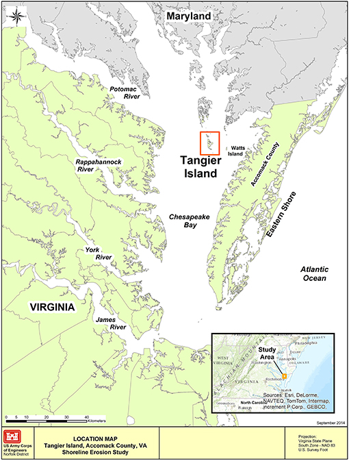
Figure 1. Location and configuration of the Tangier Island and the Town of Tangier, in Virginia waters of Chesapeake Bay, USA. Source: Schulte et al. (2015).
The Chesapeake Bay is the largest estuary in the United States, located on the Mid-Atlantic region of the East Coast, separated from the Atlantic Ocean by the Delmarva Peninsula (see Supplementary Figure 1), lands occupied by the State of Delaware, and the Eastern Shore region of the State of Maryland and the Commonwealth of Virginia. The Bay's northern half lies within the borders of the State of Maryland, the southern half within the Commonwealth of Virginia. It is a drowned river valley, inundated as glaciers melting at the end of the last Ice Age. Most of its waters are shallow, with the average depth being 7 m and the deepest waters are 53 m. At the time of initial European settlement (1600s), the Bay had hundreds of islands (1–800 ha in size); however, few of the islands were ever inhabited with a permanent population, mostly due to the lack of sufficient habitable uplands. Since the 1600s, more than 500 islands have been lost to SLR and erosion, this loss continues to this day (Cronin, 2005). One of the permanently settled islands is now the last remaining inhabited offshore island in Virginia's Bay waters, the Town of Tangier, on Tangier Island. Tangier Island lies near the end of a sunken peninsula that was inundated as the last Ice Age ended and waters rose due to glacial melting. Being an offshore Island, Tangier does not have a significant source of sand, unlike a barrier island. Tangier and other islands ranging north along the highest points of the former peninsula are typically entirely composed of sand, silts and clay, which also extends 10 m below the Islands and Bay bottom. Underneath the first 10 m of sediments is typically sand with clay lenses and occasional shell deposits until bedrock which is found much further below. The only hard substrate in the local area are oyster reefs, which range from intertidal to 10 m below the surface. Water depths around the island are shallow, typically <5 m deep within 1 km of the shoreline, with deeper channels of drowned river valleys with waters <10 m deep located offshore on both the East and West side of Tangier Island. Local tides are semi-diurnal with an average range of 0.37 m. The Island, originally settled in the 1770s by European colonists as a farming community, held significant forested uplands at the time but is now made up of mostly estuarine wetlands and three (seven at settlement) major sandy upland ridges (Heywood and Pope, 2009; Yarrington, 2020). Farming is now no longer possible due to the lack of suitable land to do so and most of the trees on the Island, including the Town, have died due to saltwater intrusion. The Town has been primarily a fishing community (fishers are locally known as “watermen”) since the mid-1800s, due to the higher potential income earned by fishing vs. farming (Cronin, 2005; Yarrington, 2020). As of 2020, the island is estimated to have a population of 436 (US Census Bureau, 2020), having shrunk from a peak of over 1,100 people in the early 1900s.
The Town consists of three upland ridges, from west to east, respectively: West, Main, and Canton (Figure 2). Their topography is mostly flat; however, there are several patches of higher ground, concentrated mostly on Canton and the northern tip of the Main ridge (Tangier Planning Commission, 1996) that range up to 1.51 m above mean higher high water (MHHW). Most of the Town's uplands are <1.0 meters above MHHW, lying within the US Federal Emergency Management Agency (FEMA) flood zone AE, a special flood hazard area well within the 100-year flood plain, and the highest ground in the Town is classed as Zone X (≥1.0 m MHW), which is a moderate flood risk area, lying between the 100 year and 500-year flood plain (Figure 3). The entire Tangier airport was elevated using dredged material and it currently one of the highest points on the Island, much of it lying in Zone X. Outside of the Town, the remaining lands are in flood zone VE, classed as lands <1.0 m above MHHW and also vulnerable to storm waves. Due to the man-made characteristics of the airport uplands, this area will not be considered as part of the natural, original ridges and was not included in our measurements.
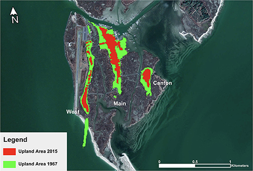
Figure 2. The three upland ridges of the Town of Tangier's upland area in 1967–2015 visualizing the extent of conversion. Map created using Esri ArcGIS, ArcMap 10.8. Source: USDA Farm Service Agency. Area found within the red rectangle of Figure 1.
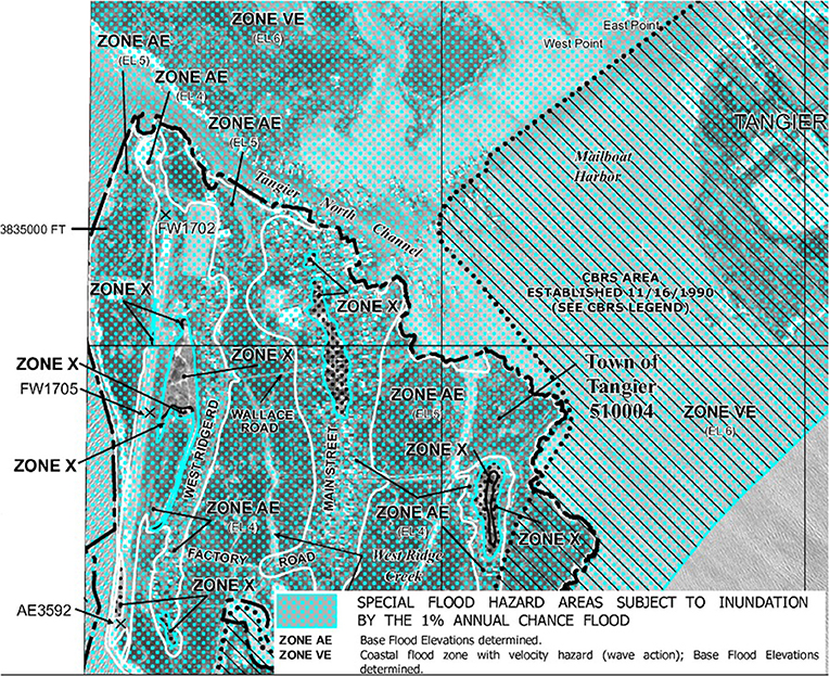
Figure 3. FEMA flood map depicting the highest uplands (flood zone X) of the Town of Tangier in brown, and illustrating the whole island, including the majority of the Town's uplands is considered to be in flood zone AE. Source: FEMA (2021). Area found within the red rectangle of Figure 1.
Analysis in the AR6 report states that “Global mean sea level increased by 0.20 [0.15 to 0.25] m between 1901 and 2018. The average rate of sea level rise was 1.3 [0.6 to 2.1] mm yr−1 between 1901 and 1971, increasing to 1.9 [0.8 to 2.9] mm yr−1 between 1971 and 2006, and further increasing to 3.7 [3.2 to 4.2] mm yr−1 between 2006 and 2018 (high confidence).” Human influence was cited as the unequivocal main driver of these SLR increases since at least 1971 (IPCC, 2021). Locally, the RSLR (relative sea-level rise) has been higher than the global mean, due to a SLR “hotspot” that exists on the East coast of North America (Koeberl et al., 1996; Kleinoksy et al., 2007; Barbosa and Silva, 2009; Yin et al., 2009; Boon et al., 2010; Sallenger et al., 2012). The Southern Chesapeake Bay region of this “hotspot” has a higher relative rate of sea level rise (RSLR of 5.9 mm/yr from 1967 to 2019, 6.35 mm yr−1 from 2010 to 2020) compared to global mean SLR (NOAA, 2020; IPCC, 2021), accelerating in tandem with the global mean rate.
The amount of time until the southern Chesapeake Bay RSLR converts the Town's remaining uplands into wetlands, a process known as Upland to Wetland Conversion, determines how long the Town has until it will very likely have to be abandoned, due to the lack of upland suitable for human habitation. Following this conversion but prior to inundation, the Island will consist entirely of wetlands. Prior studies (Kirwan et al., 2016; Schieder et al., 2018; Schuerch et al., 2018) have shown that the wetland area can stay relatively static in the Chesapeake Bay area, but this is due to SLR converting nearby uplands to wetlands at a similar rate that wave erosion and SLR destroy them (Schieder et al., 2018) or sufficient sediment supply to maintain elevation (Kirwan et al., 2016). However, in certain areas, wetlands are lost during this process (Beckett et al., 2016). Unfortunately, though this process may help maintain the wetland acreage of the Island, it is at the expense of the Town's Uplands, which will not be replaced naturally due to lack of a source of sediment to maintain present elevation. The conversion directly threatens the inhabitants of the Town, as they will likely leave as the Town is converted from habitable uplands to inhabitable wetlands because there is nowhere else on the Island to build housing above the high tide line other than the three ridges currently inhabited.
Schulte et al. (2015) found that the Island has lost 66.75% of its total landmass since 1850 (Schulte et al., 2015) due to a combination of coastal erosion and RSLR, and predicted that the Island would need to be abandoned between 2030 and 2065 due to additional loss of land from the Island's perimeter, stating that the Town of Tangier's people would be among the Continental USA's first climate change refugees. However, they did not assess direct impacts of RSLR to the Town itself, which is the main purpose of the present study. The Schulte et al. (2015) study gained significant media attention for Tangier Island and Town (Duhaime-Ross, 2016; Gertner, 2016; Gray, 2017; Testa, 2018). This media attention resulted in then-President Trump contacting Tangier's mayor and hypothesizing that Tangier Island had “hundreds of years more” (Gray, 2017), a view shared by most of the Tangier Islanders. We will assess this hypothesis, along with our own. The majority of the Islanders deny the impact of climate change and RSLR on the Island and Town, as did then-President Trump, instead attributing the land losses experienced since initial settlement-present entirely to coastal erosion. This has contributed to the misinformation about climate change regarding the reality, present severity, and predicted future impacts of climate change and stimulated our interest in conducting the present study.
Because the Town lies on upland ridges almost entirely inland of the island's shoreline, they are in large part (except for the southern tip of West Ridge) protected from coastal erosion and any loss of their area can be fully attributed to RSLR (Figure 2). The present study will determine first whether there has been any loss of uplands, and if so, the extent of and how long the Town's uplands have before complete conversion into wetlands, which are not habitable land. Our hypotheses are that, one: a significant amount of Town's uplands have already been converted to wetlands, two: that the time of full conversion to wetlands will lie within the estimate by Schulte et al. (2015) for Town abandonment, three: local RSLR is no longer following the USACE's low curve and will better fit the high curve, which is causing the acceleration in wetland conversion, and four: the Town's population decline is correlated to the decline in habitable uplands.
Materials and Methods
High-resolution aerial photographs of Tangier Island were extracted and analyzed with ArcGIS—a geo-referencing tool provided by the Environmental Systems Research Institute (Esri). The aerial imagery was provided by the US Geological Survey (USGS), Esri, National Oceanic and Atmospheric Administration (NOAA), US Department of Agriculture Farm Service Agency (USDA), and the Commonwealth of Virginia. The earliest aerial photograph with enough clarity to discern wetlands from the Town of Tangier's uplands was taken in 1967. Photographs of similar quality were acquired from the years 1970, 1994, 2007, 2008, 2011, 2013, 2014, 2015, 2016, and 2019 and are the subject of our analysis and the basis for our predictions for The Town's future (see Supplementary Figures 2–12). We were able to measure accurately the upland areas from the 2016 and 2019 aerial imagery. Unfortunately, we were unable to extract the 2016 and 2019 imagery with high enough resolution from the image owner to be presented on the map (Figure 2) illustrating the upland area change up to 2019 but the underlying image is from 2015.
To calculate the Town of Tangier's rate of upland to wetland conversion over time (1967–2019), we utilized the ArcGIS Measure Tool to measure upland areas from the time series imagery. The tool is controlled with the mouse cursor, and it measures the area of the enclosed shape drawn. This is used to trace around every patch of uplands of the three ridges to measure the upland areas. Our study seeks to determine when the Town will be abandoned due to the loss of all uplands for housing and support infrastructure (the churches, school, medical facility, shops, restaurants, water treatment, transportation, etc.). So, therefore, only impacts of RSLR to the three inhabited ridges of the Town of Tangier (32.8 ha in 1967) were considered, uninhabitable areas were excluded. Uplands from each image over time were determined and area calculated, including any fragments of uplands that were separated within a given ridge due to the upland to wetland conversion. The images came from multiple authoritative sources, so we match the scaling of each aerial image to ensure accuracy. The matching of the scale was done by matching the shoreline of the island and prominent landmarks on each map, such as school, church and town hall. The means of discerning wetlands from uplands we used in this study was a combination of wetland/upland indicators. Wetland indicators include marsh vegetation and dead upland vegetation and in black/white imagery, dark land coloration. Upland indicators include trees and lawn grass and/or lighter coloration in black and white images. Site visits were conducted to confirm the presence of wetlands and uplands as estimated via image interpretation at a haphazardly selected number of sites within the Town (see a subset of these photos at Supplementary Photos 1–6). The rate of upland to wetland conversion of each ridge was calculated. Additionally, the mean rate of conversion of all ridges was calculated to model a regression that was compared to the regression of the population data.
The ridge that will endure the longest was used to project the year in which Tangier Island will have no upland left and the Town abandoned. Data analysis was done through Microsoft Excel and the statistical analysis program, SigmaPlot. Then, we conducted an analysis of the Sewell's Point, located ~95 km South of Tangier in Virginia waters of southern Chesapeake Bay (see Supplementary Figure 13), tide gauge's raw data (1967–2020) with the sea-level rise curves predicted from the USACE's sea level change curve calculator (US Army Corps of Engineers, 2021)1 to determine the relationship of the raw Sewell's Point's RSLR data to the three USACE's sea-level rise curve scenarios (low, mid or high) in order to determine how the raw data of local RSLR is trending.
Finally, we also estimated the cost of and conceptualized a plan to relocate and one to rescue Tangier Island, the Town and its inhabitants. Estimates were developed referencing similar efforts by the US Federal government in saving similar small coastal communities from sea-level rise.
Results
The extent of the Town of Tangier's uplands converted into wetlands due to sea level rise has been extreme since 1967, especially that of the West Ridge (Figure 2). Overall, the Town's uplands have lost 61.88% of its original 1967 upland area. The West Ridge has lost (71.81%), Main Ridge (56.64%) and Canton Ridge (61.23%) from 1967–2019 due to upland to wetland conversion (Figures 2, 4). The majority of individual properties in the Town now hold some wetlands. Some properties have been converted almost entirely to wetlands, in such cases the home and any support structures (storage sheds, walkways, parking platforms) on the property have been raised (see Supplementary Photos).
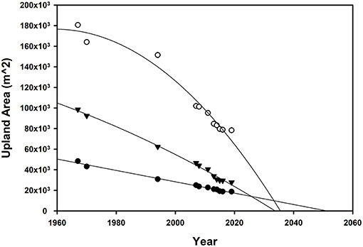
Figure 4. Regressions of the upland to wetland conversion rate of the three upland ridges [West (triangles), main (open circles), and Canton (filled circles)]. West Ridge: (y = −5.04x2 + 18,715x – 1,72,00,000), (r2 = 0.994 and p < 0.05 for all parameters). Main Ridge: (y = −30.4x2 + 119133x – 11,70,00,000), (r2 = 0.97 and p < 0.05 for all parameters). Canton Ridge: (y = −552x + 11,30,000), (r2 = 0.991 and p < 0.05 for all parameters).
We fit regressions to the data of the three ridges to predict the upland lifespan of the Town of Tangier's three ridges. The best fits (highest r2, all parameters had p < 0.05) were quadratic for West and Main Ridge and linear for Canton Ridge. The regressions for each ridge, respectively, predicted that if upland to wetland conversion and RSLR were to continue as predicted, the year of full conversion to wetlands is: 2051 (Canton Ridge), 2035 (Main Ridge) and 2033 (West Ridge), (Figure 4). Canton Ridge, despite being the smallest in area of the three, holds the largest extent of land higher than 1 m above mean high water (MHW) and the only uplands outside the airport 1.2 meters or higher (peak height is ~1.5 m MHW). Our analysis of the Sewell's Point tidal gauge raw data suggests that the RSLR of the Chesapeake Bay area is as of now between the USACE's high and middle RSLR curve, trending toward the high curve if RSLR continues to accelerate (Figure 5).
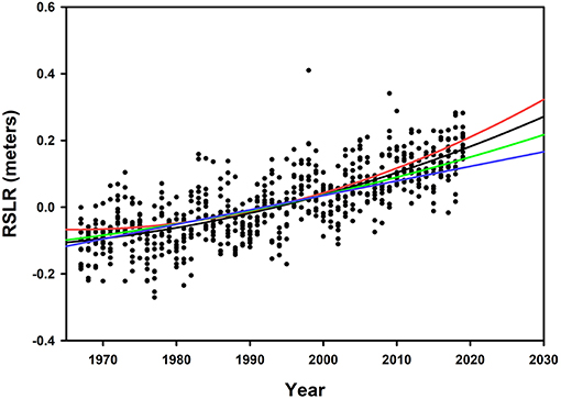
Figure 5. Low (blue), mid (green), high (red) SLR curves of the USACE compared with the raw data of Sewell's Point Tide Gauge (black) from 1967–2020. The equation for Sewell's point raw data is y = 0.00005765x2 – 0.223x + 216.869 (r2 = 0.57 and p < 0.05 for all parameters).
From our analysis of the Town population, we predict that the Town will reach a population of 0 by the year 2053, tracking quite similarly with the overall wetland conversion rate of the three ridges' uplands combined curve (Figure 6). This result is consistent with our prediction with the full conversion of the last Town uplands by 2051 (Figure 4). To confirm our findings of the current upland extent, we compared our findings (Figure 2) to the results of a recent light detection and ranging (LIDAR) survey done over the southern portion of Tangier Island that includes the Town (Figure 7) and noted that our estimation of upland location was confirmed by the LIDAR survey, though it must be noted that the transition from wetlands to upland does not occur precisely at the 2-foot (0.6096 m) contour.
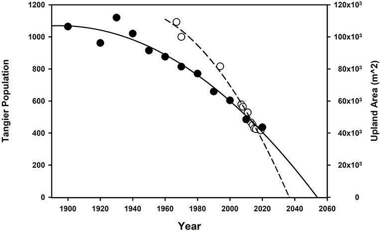
Figure 6. Regression of both the population decline and the overall rate of wetland conversion of all three ridges combined for the Town of Tangier. The filled circles and the solid line represents the population decline. The open circle and the dashed line represent the overall wetland conversion rate. Population decline regression: (y = −1,49,913.413 – 0.042x2 + 159.404x), (r2 = 0.96 and p < 0.05 for all parameters). Overall wetland conversion rate regression: (y = −12,72,18,187.167 – 34.086x2 + 1,31,885.035x), (r2 = 0.99 and p < 0.05).
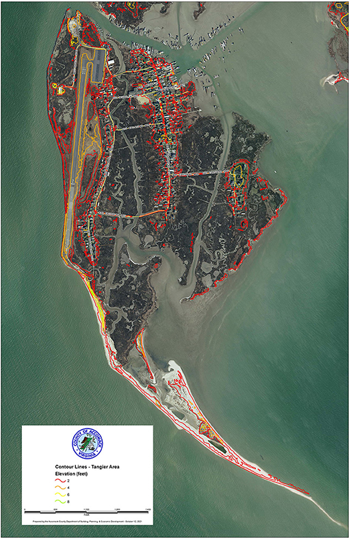
Figure 7. LIDAR survey of the southern portion of Tangier Island and the Town of Tangier (2 feet = 0.61 m, 4 feet = 1.22 m, 6 feet = 1.83 m). Source: Accomac County. Imagery is from 2017.
Discussion
Our analysis confirms that the Town of Tangier has already been severely impacted by climate-change-induced SLR. The West Ridge is converting the fastest, however, the curve of the Main ridge appears to be more aggressive compared to the West Ridge. Canton, which our analysis shows will last the longest due to its possession of the highest ground on the Island, was also the first ridge to be settled by European colonists, likely due to its higher elevation, which provides more protection against hurricane-induced flooding. Main and West Ridge were initially where much of the early farming occurred (Hall, 1939). We reason that the much larger upland area of the Middle ridge has allowed for it to endure its more aggressive conversion rate. The southernmost tip of West Ridge converted from uplands to wetlands between 1970 and 1982 (Historic Aerials, 2021), resulting in the loss of several homes. It was further impacted by coastal erosion and continuing RSLR and is now underwater. Erosion is not a factor due to the inshore position of the three upland ridges except for this small area (Figure 2). This area was located south of the shoreline revetment built to protect the airport and is the shoreline of Tangier Island that experiences the highest rate of land loss (Schulte et al., 2015), so this is not surprising. It provides a modern-day prelude of the fate of the rest of the Town. The conversion of all three ridges lies within the Schulte et al. (2015) estimate of the Islands habitability and provides an alarming timeline for the Town of Tangier, not just the Island as a whole. Even if stones were placed surrounding the Island, halting coastal erosion, this abandonment due to sea-level rise would still occur. Stones alone will not be able to halt the rising water seeping up through the sandy uplands of the Town. Due to this, the Town of Tangier will have to be relocated earlier than estimations based on inundation.
The data and analysis suggest there is also a significant relationship between the decline in habitable uplands and the number of citizens of the Town of Tangier, despite the majority of the citizen's steadfast refusal to accept climate change as real. Based on the regression of the rate of population decline (Figure 6), by 2053 the people of the Town of Tangier will complete their exodus. While it is likely that a host of factors drive this decline, such as difficulties in young people obtaining commercial fishing licenses and associated gear, lack of employment on the island, and the internet, which ended the Town's isolation, some of these have a link to sea-level rise as, for example, there are no open uplands that could be developed for new commercial or residential use. There is also a sense of frustration, futility and abandonment for the state and Federal governments by the Islanders, which also encourages Islanders to move off the Island. There is good reason the Islanders hold such feelings. For example, the stone revetment that was built in 1989 using funds from Tangier Islanders, state and Federal governments to protect the Tangier Airport was requested by the Tangier Islanders decades before, around 1960 (Yarrington, 2020). The only new business of consequence in recent years is a nearshore oyster aquaculture operation. Older adults, who have seen the decline in extent and quality of the lands of the Town of Tangier, also tend to encourage their children to leave the Island. Many young people do so and as a result, the remaining population of the Town of Tangier is also aging (Swift, 2018).
These social issues should be addressed if a large-scale intervention to restore the Town is undertaken. For example, aid in obtaining a commercial fishing license and associated fishing gear for young people who wish to follow the path of their ancestors and become watermen, efforts to increase tourism, and expansion of aquaculture in Tangier's nearshore waters, could be considered.
The data also supports our fourth hypothesis and rejects the alternative, that the Town of Tangier and the Island “has hundreds of years more (Gray, 2017).” They have but a few short decades. It is also possible that the final exodus of the Town's citizens could occur earlier than final conversion of all uplands. Once infrastructure such as the Churches, grocery store, school and others become too difficult to maintain, due to flood-related expenses, impacts and lack of dry land, or there becomes too few people to support their maintenance, these facilities will have to close. This would accelerate the exodus of the last Tangier Islanders from their home.
As noted, additional actions beyond placing stones at vulnerable points of the Island's perimeter will be needed if the Town of Tangier is to be saved from rising waters. The Town will need to be raised, or it will soon need to be abandoned. The Schulte et al. (2015) study proposed an interim plan to buy the island some time, mainly by supplying sediment to the western shore of the island and protecting the most vulnerable shorelines with additional stone at an estimated cost of 30–50 million USD. This approach did not assess the long-term costs associated with saving the Town, which needs to be elevated to remain habitable as sea level rises. We will estimate these costs, as well as estimate the cost of relocating the Town of Tangier and its people. The Town has a complete infrastructure, including utilities, roads, fuel storage, commercial fishing facilities, homes, churches, cemeteries and educational, recreational, and tourism-related infrastructure. Regarding abandonment of the Town and exodus of its people, all of this will need to be either decommissioned and removed (utilities) to possibly be relocated physically (homes, churches, cemeteries, the school) or simply abandoned (homes, cemeteries, and structures with non-toxic materials). Physically relocating over 400 people, all their homes and belongings, and decommissioning the Town will be an expensive undertaking. Several USA Federal government estimates of costs (US Army Corps of Engineers, 2004; US Government Accountability Office, (GAO), 2009) to relocate for small coastal towns in similar, dire climate-change driven situations include: the Towns of Shishmaref (pop. 563), (100–200 million USD), Newtok (pop. 354), (80–130 million USD), and Kivalina, AK (pop. 374), (95–125 million USD); the Quinault Nation (pop. ~600), (60–100 million USD) in WA, and Isle de Jean Charles (pop. 99), (48 million USD), LA. Due to the size of the Town of Tangier, its extensive infrastructure, and its offshore island nature, relocating the Town will likely be on the higher end of these estimates, from 100 to 200 million USD.
What about saving the Town? We estimate it would cost roughly 250–350 million USD to fully protect and restore the Town of Tangier and Tangier Island. Primary, necessary actions included in this estimate are applying protective stone along all vulnerable shorelines of the Island (a significant portion of the shoreline would not need such protection), raising the ~35 ha of the three ridges by 3 m using sand dredged from the bottom of Chesapeake Bay, retrofits of plumbing and electrical throughout the Town, and raising the system of one-lane roads for transportation.
Recommended secondary actions to further aid Tangier Island and increase longevity would include the use of Natural and Nature-Based Features (NNBF), which can be effectively used to enhance local ecosystems and nearby built infrastructure's resilience against SLR (Narayan et al., 2016; Whitfield et al., 2020). Estimated costs were developed for NNBF restoration at Tangier Island, based on current literature (Bridges et al., 2015; Aerts, 2018). All NNBF considered either are present, though significantly reduced in extent compared to historical conditions, or were once present but are currently extirpated. While these NNBF are not the primary means to save the Town, they will assist in improving the long-term stability of the Island and Town and greatly increase their ecological value. There are still remnant dunes south of the West Ridge and in a few other areas, including the uninhabited Uppards. At initial European settlement, the Island still held extensive forested areas, though today these are entirely extirpated except for a small area on the easternmost sub-islet of Tangier, which was actively restored by placement of dredged material to elevate the land, then planted with trees. Oyster reefs are still common, especially subtidal. Intertidal reefs were exploited by Native Americans pre-European colonization as well as by early European settlers as evidenced by shell middens scattered over the Island (Yarrington, 2020). We recommend thin spray dredging, an application of a 10–15 cm thick layer of material on top of existing wetlands to slow inundation by raising the elevation of the wetland and enhance vegetative growth (Ford et al., 1999; Ray, 2007; VanZomeren and Piercy, 2019) at an estimated cost of 5–10,000 USD/ha. Restoring several areas of former uplands on abandoned lands North of the Town as dunes at an estimated cost of 15–30,000 USD/ha, then creating maritime forested uplands behind them on newly elevated land behind the dunes at the cost of 15–50,000 USD/ha would help protect the Town from severe winter storms coming from a more northern direction, known as a Nor'easter in the USA. A final recommended action for Tangier Island and the Town is to construct nearshore, low-intertidal, high-relief oyster reefs at an estimated cost of 100,000–300,000 USD/ha, depending on materials used and height of the restored reef to help protect the unarmored shorelines from wave energy and associated coastal erosion (Wilberg et al., 2019) on the east side of the Island.
These costs, whether to save or abandon the Town and Island of Tangier are substantial, but it can and has been done before. For example, in Maryland, Poplar Island, whose area reduced to 5 acres by 1993 by a combination of erosion and RSLR, is currently being restored to its ~1,840 footprint of 1,715 acres at a cost of 1.4 billion USD. This Island, similar to Tangier, was also settled by European colonists and was permanently settled. The Town on Poplar Island was known as Valliant, which persisted until the 1920s when it was abandoned due to rising waters and erosion-driven loss of land. The restoration effort for Poplar Island is not intended to make the island habitable, but for wildlife habitat enhancement. This undertaking is driven by the need to maintain the depth of the main shipping channel leading to Baltimore Harbor, Maryland. This restoration effort is the least expensive means to dispose of locally dredged material by disposing of dredged materials at the Poplar Island site (USACE, 2021). That Poplar Island is being restored as a wildlife habitat, and is not intended for permanent human settlement, while the continuing decline of Tangier Island and its Town proceeds is a source of much consternation in the Town populace (Gertner, 2016; Swift, 2018; Yarrington, 2020). The issue here is simple economics: there is a need to cheaply dispose of dredged material near Poplar Island, which has stimulated its restoration efforts. Unfortunately for Tangier, there is no such need, a fact which may seal the fate of the Town of Tangier.
Lastly, this study suggests that the current sea level rise trend in the Chesapeake Bay has been recently trending toward the USACE's high curve (Figure 5) in agreement with recent acceleration in global mean SLR (IPCC, 2021). This is an alarming trend that, unless bold, collective, worldwide human intervention to slow carbon emissions becomes a priority for humanity, will continue to accelerate. Our study also suggests that coastal protection infrastructure built in the near future will likely need to consider and prioritize means to counter the higher-range SLR scenarios for their region, rather than using a low or mid-range scenarios, which appear increasingly optimistic. The latest IPCC report (2021) predicts we have only a short time (10–15 years) left to significantly reduce carbon emissions worldwide to avoid the worst-case scenario of exceeding 1.5°C. Our study supports these grim findings and suggests that the Town of Tangier is in its end times. Abandonment of the Town and exodus of its people will almost certainly occur in within a few decades due to accelerating sea-level rise without significant human intervention. The Town of Tangier's citizens will join the growing numbers of humanity forced to relocate due to climate change, becoming climate change refugees. That this is happening such a short distance away (150 km) from the Capital of the USA in Washington DC and proceeding apace with little aid despite all the media attention Tangier Island and the Town have had should alarm us all.
If the Town and Island of Tangier are saved via human intervention or abandoned to rising waters and its people relocated to the mainland is beyond the scope of the present study, but it is a choice that will soon need to be made by policymakers. The choices they make will soon define how our fellow Americans in the USA most vulnerable to climate change, which are often Native American, minority, or low-income such as the isolated fishing community of Tangier, will have their needs addressed—or ignored. The same holds true for many coastal communities throughout the world (Loughry and McAdam, 2008). Ultimately, the actions we take (or don't take) collectively will determine how many more towns and cities will end up like the Town of Tangier in coming decades. As a local example: In Chesapeake Bay, Holland Island, once a thriving community of ~360, is now a sand bar covered by high tide. Abandoned in 1922 due to land losses caused by erosion and RSLR, desperate attempts were made to preserve the last of its lands for decades. These lands after 1922 were mostly a seabird rookery but included several graveyards and the last house standing. By 2010, this last home succumbed to the rising waters of the Bay, by 2012 the graveyards and rookery (Foley and Rue, 2015; White, 2015). A similar loss of graveyards recently occurred at the formerly inhabited ridge of Tangier Island, Canaan, abandoned in the 1930s due to its isolation, erosion and RSLR, the bones of the formerly buried now scattered over the shore (Mayfield, 2017; Swift, 2018). Soon, the rest of the Town of Tangier will be uninhabitable due to sea level rise. The question we pose for policymakers is: “What will it take for you to act?”
Data Availability Statement
The raw data supporting the conclusions of this article will be made available by the authors, without undue reservation.
Author Contributions
ZW and DS contributed to study conception and design. ZW collected the island imagery and related data. DS collected the data related to sea level rise and performed statistical analysis on local sea level rise and population decline. ZW performed the statistical analysis on upland conversion, wrote the first draft of the manuscript, except for the sea level rise and section on costs of Town/Island abandonment, and conceptual restoration plan which was written by DS. Both authors contributed to manuscript revision, read and approved the submitted version.
Conflict of Interest
ZW and DS are employed by Biogenic Solutions Consulting, LLC.
Publisher's Note
All claims expressed in this article are solely those of the authors and do not necessarily represent those of their affiliated organizations, or those of the publisher, the editors and the reviewers. Any product that may be evaluated in this article, or claim that may be made by its manufacturer, is not guaranteed or endorsed by the publisher.
Supplementary Material
The Supplementary Material for this article can be found online at: https://www.frontiersin.org/articles/10.3389/fclim.2021.779774/full#supplementary-material
Footnotes
References
Aerts, J. C. (2018). A review of cost estimates for flood adaptation. Water 10:1646. doi: 10.3390/w10111646
Barbosa, S. M., and Silva, M. E. (2009). Low-frequency sea-level change in Chesapeake Bay: changing seasonality and long-term trends. Estuar. Coast. Shelf Sci. 83, 30–38. doi: 10.1016/j.ecss.2009.03.014
Beckett, L. H., Baldwin, A. H., and Kearney, M. S. (2016). Tidal marshes across a chesapeake bay subestuary are not keeping up with sea-level rise. PLoS ONE 11:e0159753. doi: 10.1371/journal.pone.0159753
Boon, J. D., Brubaker, J. M., and Forrest, D. R. (2010). Chesapeake Bay Land Subsidence and Sea Level Change: An Evaluation of Past and Present Trends and Future Outlook. Virginia Institute of Marine Science.
Bridges, T. S., Burks-Copes, K. A., Bates, M. E., Collier, Z. A., Fischenich, J. C., Piercy, C. D., et al. (2015). Use of Natural and Nature-Based Features (NNBF) for Coastal Resilience. US Army Engineer Research and Development Center, Environmental Laboratory, Coastal and Hydraulics Laboratory.
Duhaime-Ross, A. (2016). Climate change is pushing this Virginia Island into the Sea. VICE News. Available online at: https://www.vice.com/en/article/mbpq4b/tangier-island-virginia-sinking (accessed September 18, 2021).
Farbotko, C. (2010). Wishful sinking: disappearing islands, climate refugees, and cosmopolitan experimentation. Asia Pac. Viewp. 51, 47–60. doi: 10.1111/j.1467-8373.2010.001413.x
FEMA (2021). FEMA Flood Map Service Center: Search by Address. Available online at: https://msc.fema.gov/portal/search?AddressQuery=Tangier%20Island#searchresultsanchor (September 19, 2021).
Foley, A. M., and Rue, P. S. (2015). Holland Island: Lost Atlantis of the Chesapeake. Washington, DC: Dogwood Ridge Books.
Ford, M. A., Cahoon, D. R., and Lynch, J. C. (1999). Restoring marsh elevation in a rapidly subsiding salt marsh by thin-layer deposition of dredged material. Ecol. Eng. 12, 189–205. doi: 10.1016/S0925-8574(98)00061-5
Gertner, J. (2016). Should the United States save Tangier Island from oblivion? The New York Times. Available online at: https://www.nytimes.com/2016/07/10/magazine/should-the-united-states-save-tangier-island-from-oblivion.html (accessed September 18, 2021).
Gray, J. (2017). CNN report prompts Trump to call mayor of Disappearing Island. CNN. Available online at: https://www.cnn.com/2017/06/15/us/weather-president-trump-calls-tangier-mayor/index.html (accessed September 18, 2021).
Hall, S. W. (1939). Tangier Island: a study of an isolated group (Dissertation). University of Pennsylvania, Philadelphia, PA, USA.
Heywood, C. E., and Pope, J. P. (2009). Simulation of Groundwater Flow in the Coastal Plain Aquifer System of Virginia. US Geological Survey. doi: 10.3133/sir20095039
Historic Aerials (2021). Historic Aerials. NETRonline: Historic Aerials. Available online at: https://www.historicaerials.com/viewer (accessed September 18, 2021).
IPCC (2021). Summary for Policymakers. In: Climate Change 2021: The Physical Science Basis. Contribution of Working Group I to the Sixth Assessment Report of the Intergovernmental Panel on Climate Change. Cambridge University Press.
Kirwan, M. L., Temmerman, S., Skeehan, E. E., Guntenspergen, G. R., and Fagherazzi, S. (2016). Overestimation of marsh vulnerability to sea level rise. Nat. Clim. Change 6, 253–260. doi: 10.1038/nclimate2909
Kleinoksy, L. R., Yarnal, B., and Fisher, A. (2007). Vulnerability of Hampton Roads, Virginia to storm-surge flooding and sea level rise. Nat. Hazards 40, 43–70. doi: 10.1007/s11069-006-0004-z
Koeberl, C., Poag, C. W., Reimold, W. U., and Brandt, D. (1996). Impact origin of the Chesapeake Bay structure and the source of the North American tektites. Science 271, 1263–1266. doi: 10.1126/science.271.5253.1263
Loughry, M., and McAdam, J. (2008). Kiribati–relocation and adaptation. Forced Migr. Rev. 31, 51–52.
Mayfield, D. (2017). As Waves Unearth Old Graves on the island, Tangier's Past could be a Glimpse into its Future. Available online at: https://www.pilotonline.com/news/environment/article_b12eb4fa-b15e-5441-a8b8-15f1660064f7.html (accessed September 18, 2021).
Narayan, S., Beck, M. W., Reguero, B. G., Losada, I. J., Van Wesenbeeck, B., Pontee, N., et al. (2016). The effectiveness, costs and coastal protection benefits of natural and nature-based defences. PLoS ONE 11:e0154735. doi: 10.1371/journal.pone.0154735
NOAA (2020). Sea Level Trends-NOAA Tides and Currents. Available online at: https://tidesandcurrents.noaa.gov/sltrends/sltrends_station.shtml?id=8638610 (accessed September 11, 2021).
Ray, G. L. (2007). Thin Layer Placement of Dredged Material on Coastal Wetlands: A Review of the Technical and Scientific Literature. Defense Technical Information Center.
Sallenger, A. H., Doran, K. S., and Howd, P. A. (2012). Hotspot of accelerated sea-level rise on the Atlantic coast of North America. Nat. Clim. Change 2, 884–888. doi: 10.1038/nclimate1597
Schieder, N. W., Walters, D. C., and Kirwan, M. L. (2018). Massive upland to wetland conversion compensated for historical marsh loss in Chesapeake Bay, USA. Estuaries Coasts 41, 940–951. doi: 10.1007/s12237-017-0336-9
Schuerch, M., Spencer, T., Temmerman, S., Kirwan, M. L., Wolff, C., Lincke, D., et al. (2018). Future response of global coastal wetlands to sea-level rise. Nature 561, 231–234. doi: 10.1038/s41586-018-76-5
Schulte, D. M., Dridge, K. M., and Hudgins, M. H. (2015). Climate change and the evolution and fate of the Tangier Islands of Chesapeake Bay, USA. Sci. Rep. 5, 1–7. doi: 10.1038/srep17890
Swift, E. (2018). Chesapeake Requiem: A Year with the Watermen of Vanishing Tangier Island. New York, NY: Dey Street Books.
Tangier Planning Commission (1996). Comprehensive Plan for the Town of Tangier. Available online at: https://www.govinfo.gov/content/pkg/CZIC-ht168-v8-t36-1996/html/CZIC-ht168-v8-t36-1996.htm (accessed September 11, 2021).
Testa (2018). The Human Element. Available online at: https://thehumanelementmovie.com/ (accessed September 18, 2021).
US Army Corps of Engineers (2004). Shishmaref Partnership: Shishmaref Relocation and Collocation Study. Preliminary Costs of Alternatives. US Army Corps of Engineers.
US Army Corps of Engineers (2021). Sea-Level Change Curve Calculator (Version 2021.12). Available online at: from https://cwbi-app.sec.usace.army.mil/rccslc/slcc_calc.html (accessed September 17, 2021).
US Census Bureau (2020). Population and Housing Unit Estimates Tables. The United States Census Bureau. Available online at: https://www.census.gov/programs-surveys/popest/data/tables.2019.html (accessed September 11, 2021).
US Government Accountability Office, (GAO). (2009). Alaska Native Villages: Limited Progress has been Made on Relocating Villages Threatened by Flooding and Erosion. US Government Accountability Office.
USACE (2021). Poplar Island Restoration. US Army Corps of Engineers Baltimore District Website. Available online at: https://www.nab.usace.army.mil/missions/environmental/poplar-island/ (accessed September 19, 2021).
VanZomeren, C. M., and Piercy, C. D. (2019). Thin Layer Placement of Sediments for Restoring Ecological Function to Salt Marshes: A Quantitative Review of Scientific Literature. DOER Technical Notes Collection. ERDC/TN DOER-E44. U.S. Army Engineer Research and Development Center. doi: 10.21079/11681/35373
White, S. L. (2015). The Day The Laughter Died The Story of Holland Island on the Chesapeake Bay. Berlin, MD: Salt Water Media.
Whitfield, P., Davis, J., Szimanski, D., King, J., Gailani, J., Herman, B., et al. (2020). Island restoration to meet'triple-win'engineering with nature outcomes. Coast. Eng. Proc. 36, 11–11. doi: 10.9753/icce.v36v.management.11
Wilberg, P. L., Taube, S. R., Ferguson, A. E., Kremer, M. R., and Reidenbach, M. A. (2019). Wave attenuation by oyster reefs in shallow coastal bays. Estuaries Coasts 42, 331–347. doi: 10.1007/s12237-018-0463-y
Yarrington, J. (2020). A Time to Every Purpose: Kinship, Privilege, and Succession on a Disappearing Island (Dissertation). School of Anthropology, University of Arizona, Tucson, Arizona.
Keywords: sea level rise, Tangier Island, exodus, population, climate change, uplands, wetlands, conversion
Citation: Wu Z and Schulte D (2021) Predictions of the Climate Change-Driven Exodus of the Town of Tangier, the Last Offshore Island Fishing Community in Virginia's Chesapeake Bay. Front. Clim. 3:779774. doi: 10.3389/fclim.2021.779774
Received: 19 September 2021; Accepted: 20 October 2021;
Published: 08 November 2021.
Edited by:
Swadhin Kumar Behera, Japan Agency for Marine-Earth Science and Technology (JAMSTEC), JapanReviewed by:
Hajime Kayanne, The University of Tokyo, JapanShion Sekizawa, The University of Tokyo, Japan
Copyright © 2021 Wu and Schulte. This is an open-access article distributed under the terms of the Creative Commons Attribution License (CC BY). The use, distribution or reproduction in other forums is permitted, provided the original author(s) and the copyright owner(s) are credited and that the original publication in this journal is cited, in accordance with accepted academic practice. No use, distribution or reproduction is permitted which does not comply with these terms.
*Correspondence: David Schulte, RGF2aWQuTS5TY2h1bHRlQHVzYWNlLmFybXkubWls
†These authors have contributed equally to this work and share first authorship