 Patricio López Mendoza
 Rodrigo Loyola
 Carlos Carrasco3
- 1Museo de Historia Natural y Cultural del Desierto de Atacama, Santiago, Chile
- 2Instituto de Investigaciones Arqueológicas y Museo, Universidad Católica del Norte, San Pedro de Atacama, Chile-UMR 8068, Technologie et Ethnologie des Mondes PréhistoriqueS (TEMPS)- Université Paris Nanterre, Nanterre, France
- 3Colegio de Arqueólogos, Santiago, Chile
- 4NSA Consultores, La Serena, Chile
- 5Escuela de Antropología, Pontificia Universidad Católica de Chile, Santiago, Chile
We discuss the process of human re-occupation of the Southern Puna (25°-27°S) during the Late Holocene through a variety of lines of evidence, such as ceramics, faunal bones, lithic technology, sources of raw materials like obsidian, and rock art, and their integration with spatial analyses using least-cost paths. Our results indicate a process in which niches were formed in the puna, focused on a variety of activities such as vicuña hunting; exploitation of lithic sources, minerals and pigments; camelid grazing; symbolic manifestations, and inter-Andean circulation. This suggests that human dynamics in the highlands of the Southern Puna toward the Late Holocene were motivated by a range of biotic and abiotic resources, and different modes of occupation, which tended to become diversified in the long term; nevertheless, they retained a common base in vicuña hunting and obsidian procurement, circulation and exchange.
1 Introduction
Human subsistence in high altitude environments poses unique biological and cultural adaptive challenges. Nonetheless, human exploration and settlement of these spaces in various regions of the world occurred at an early date, from the end of the Pleistocene (Aldenderfer, 2011; Brantingham et al., 2013; Barton, 2016; Borrero and Santoro, 2022; Zhao et al., 2023). In the case of the Andean Puna, recent investigations have shown that the initial peopling of the highlands occurred at different times for each region, triggering independent cultural courses (Rademaker et al., 2014; Capriles et al., 2016; Yacobaccio, 2017; Borrero and Santoro, 2022). The local sequences reconstructed in each area show large fluctuations in the long term, both in intensity and in the modes of occupation of the highlands. In particular, in the South-Central Andes a remarkable drop occurs in the intensity of the archaeological signal in the Middle Holocene (Núñez et al., 1999, 2002; Yacobaccio and Morales, 2005; Pintar, 2009, 2014; Barberena et al., 2017, etc.), recovering at the start of the Late Holocene with the improvement in climatic conditions.
Recent studies in the southern part of the Andean Puna, known locally as the Puna de Copiapó, appear to confirm and expand the southern extent of this event. Many sites and finds recorded in the basins of the Infieles, Pedernales, Maricunga, and Alto Jorquera present a remarkable lacuna in occupation during the Middle Holocene (López et al., 2021a, 2023b). The area was gradually re-occupied only well into the Late Holocene, with a notable increase in the material evidence in later periods. Based on the spatial and temporal variability of the archaeological record, our principal object in the present work is to evaluate the process of human re-occupation of the Puna de Copiapó during the Late Holocene. To attain this objective, our study uses an interdisciplinary approach to address various aspects relating to the mobility, settlement and technology of human societies, and how these relate with climate change events on a regional scale.
Our result points to three main directions. The first indicates that the arid event of the Middle Holocene had a significant impact on human mobility, manifested in lower or non-existent occupation of the area from 7,600 to 4,000 cal. BP. Second, the reappearance of the archaeological signal during the Late Holocene agrees with an improvement in environmental conditions ~3,000 years ago. The re-establishment of a wetter environment resulted in the formation of productive zones like wetlands and marshes, attracting hunter-gatherer groups who exploited the highlands on a seasonal basis as part of seasonal mobility circuits connecting different eco-zones like valleys and the coast. Finally, more extensive and diverse occupation of these environments occurred during later agro-ceramic periods, based on niche construction (sensu Zedeño et al., 2014). This required a significant investment of effort, the mobilization of communal work, and a certain knowledge of animal ethology, and would also have created tensions over territorial ownership, especially in pastoral societies (Lemke, 2021). Factors like the introduction of domestic animals and plants encouraged expansion to the highest limits of the agricultural systems in which they were produced, and also to the limits of the human physiological capacity to resist high altitude (over 2,500 masl), requiring and fostering new cultural solutions for high altitude environments (Barton, 2016).
2 Study area and environmental context
The Andes Mountains form the western border of South America over its whole length. The Atacama Region (26°-29°S), in the extreme north of Chile, holds the largest concentration of peaks over 6,000 masl in the country, such as Nevado San Francisco, Incahuasi, Tres Cruces and Nevado Ojos del Salado, the latter being the highest mountain in Chile at 6,893 masl. To the west, the Andes are flanked by the almost parallel Domeyko Range; between the two ranges lies the Great Pre-Altiplano Depression, formed by a chain of basins at altitudes between 3,300 and 4,200 masl. In recent years, we have carried out a high-mountain archaeology project in the salares (salt flats) of Infieles (26°S), Pedernales (26°S), Maricunga (26°S), Laguna Negro Francisco (27°S) and the basin of the upper Jorquera River (27°S) (Figures 1, 2a–d). The basin of Salar de Infieles covers an area of 293 km2 and the actual salt flat is around 6.7 km2 at a mean altitude of 3,520 masl. The basin of Salar de Pedernales (26°S) covers an area of 3,620 km2 and the salt flat covers around 335 km2 with a mean altitude of 3,356 masl. The Salar de Maricunga is an endorheic basin at 3,760 masl with affluents like the Colorado, Lamas and Ciénaga Redonda rivers. The salt flat covers 145 km2, while the area of the basin is 3,045 km2 and the area of its lagoons is 6 km2. The Negro Francisco lagoon is a salt-water lake at an altitude of 4,110 masl; the basin covers 933 km2 and the area covered by lagoons is 24.8 km2. Finally, the upper basin of the Jorquera River is one of the affluents of the Copiapó River; it is located in a transitional zone between the Puna and the principal range of the Andes, with rougher, more mountainous relief. This area is known as Vegas de Caspiche, due to the numerous marshes (vegas) that have formed at the base of Caspiche mountain. Lakes, wetlands and extensive salt flats form in the floors of all the basins, with abundant populations of flamingos (Phoenicoparrus andinus and Phoenicopterus chilensis) and other water birds such as egrets (Egretta thula and Ardea alba), various species of ducks (Anas flavirostris, Spatula puna, Lophonetta specularioides, etc.), camelids (Lama guanicoe and Vicugna vicugna), foxes (Lycalopex culpaeus and Lycalopex griseus), rodents like the tucu-tucu (Ctenomys spp.) and vizcachas (Lagidium viscacia), lizards (Liolaemus spp.), iguanas (Callopistes maculatus), and amphibians (Rhinella spinulosa).
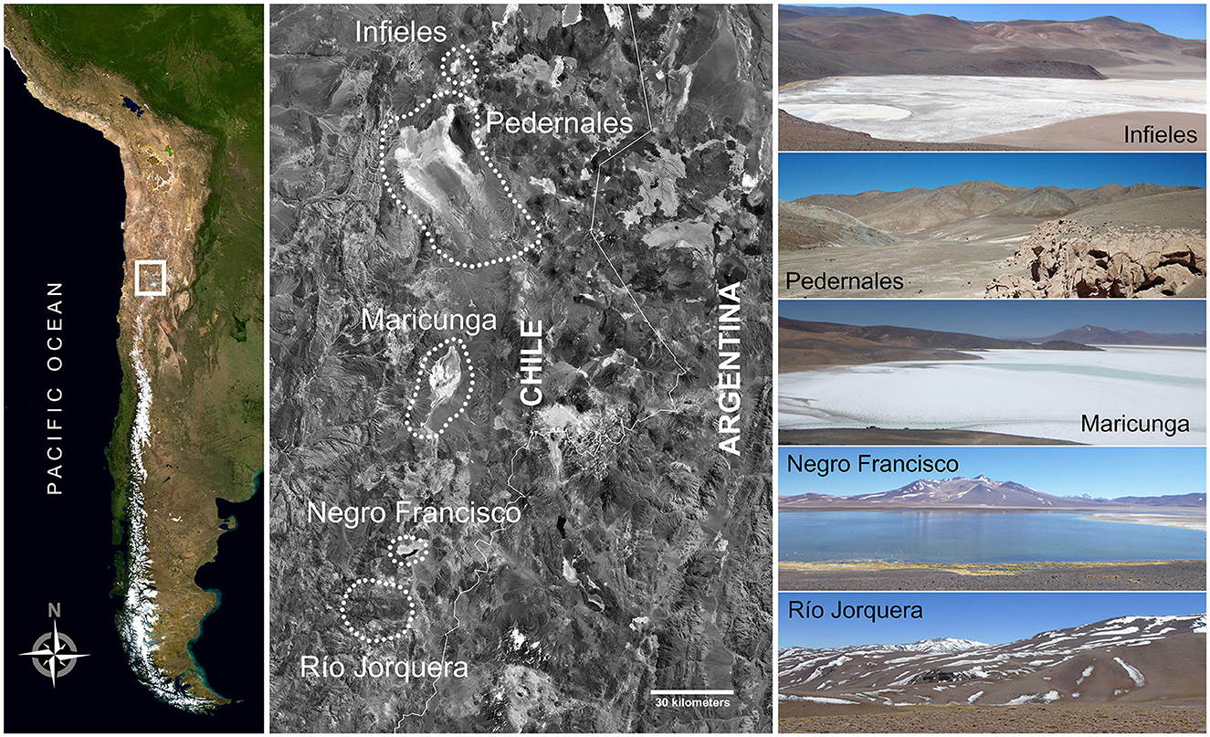
Figure 1. Study area and modern landscapes of the basins studied.
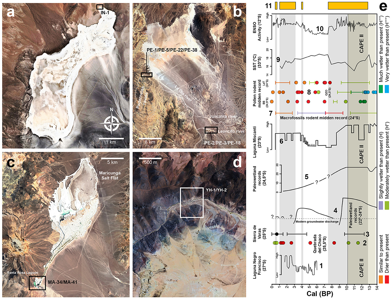
Figure 2. Location of the archaeological sites mentioned in the text in the salt flats of: (a) Infieles, (b) Pedernales, (c) Maricunga, and (d) Río Jorquera; (e) Paleo-climatic records of the Late Pleistocene and Holocene in the southern area of the Atacama Desert: 1. Water levels of Laguna del Negro Francisco; 2. Rodent midden pollen records from Quebrada del Chaco (25–30°); 3. Occurrence of groundwater discharge deposits from Sierra de Varas (25°S); 4. Groundwater discharge levels inferred from paleo-wetlands (22–24°S); 5. Local water table levels of paleo-wetlands at Salar de Punta Negra (24.5°S); 6. Lake levels of Laguna Miscanti (23°S); 7. Plant macrofossils midden record at 24°S; 8. Rodent midden pollen records; 9. Sea-surface temperature evolution in the Southeast Pacific; 10. ENSO activity in the tropical Pacific; 11. Temporary blocks of archaeological sites excavated in the Puna de Atacama. (e) Modified from De Porras et al. (2017).
The vegetation is Andean, dominated by grasslands, geophytes, marshes and bogs (bofedales), consisting principally of small bushes and grasses characteristic of the high steppes. There are also azonal formations, in the form of wetlands in the bottom of the ravines. Although the current climate is arid, the paleo-environmental records indicate various fluctuations in the past (Figure 2e). A climate marked by pulses of greater humidity has been inferred for the Late Pleistocene and Early Holocene (Lamy et al., 1998, 2000; Kull et al., 2002; Zech et al., 2006; Riquelme et al., 2011; Sáez et al., 2016), contemporary with the hydro-climatic anomaly known as the Central Andean Pluvial Event (CAPE; Latorre et al., 2006; Quade et al., 2008). The Middle Holocene, in contrast, is associated with a drier, warmer climate (Maldonado and Rozas, 2008). The first signs of this process of reduced humidity appear around 8,600 years BP, but it is from 7,700 years BP until 5,000 years BP that a drastic reduction in precipitations and a clear increase in temperature are recorded (Grosjean et al., 1997; Kim et al., 2002; Maldonado et al., 2005; Maldonado and Villagrán, 2006; Sáez et al., 2016). The regional recovery in environmental conditions occurred only from the Late Holocene (Maldonado and Rozas, 2008), although it was likewise interrupted by alternating drier and wetter phases (Maldonado et al., 2016). In the Negro Francisco lagoon, studies of lake sediments reveal pulses of higher humidity in the periods 3,000–2,600 and 2,200–1,800 years BP, related with glacial advances (Grosjean et al., 1997). Similar trends were identified from the formation of fluvial fans (Veit, 1996) and the increases in the water tables in Sierra de Varas (Sáez et al., 2016). Isotope records in cellulose obtained in high Andean bofedales in the Cordillera de Copiapó (Lagunillas area, 27°S), and comparison with records obtained in basins in north-western Argentina (NWA), suggest relatively humid conditions between 1,530 and 1,270 BP (Kock et al., 2020).
3 Archaeological background
Dates obtained in sites studied in the Puna de Copiapó allow us to contextualize human dynamics according to the chrono-cultural sequences proposed for the region. Recent studies in the Salar de Infieles (25°S) indicate an initial event of human occupation in site IN-1 at the end of the Pleistocene, from 12,800 to 11,900 cal. BP (López et al., 2023a). This event is followed by a second pulse of occupation during the Early Holocene, from 11,500 to ~8,000 cal. BP (López et al., 2022, 2024) in what is described for this area as the Early Archaic Period (Cabello et al., 2010; Troncoso et al., 2016). The archaeological record of this phase comes from sites PE-5 and PE-38, two hunter-gatherer occupations. The evidence recovered suggests a link with the Huentelauquén Cultural Complex on the Pacific coast (Cervellino, 1998), the Tuina-Tambillo tradition of the Atacama basin and NWA (Núñez et al., 2002), and the lithic industries of Salar de Imilac and Punta Negra (Lynch, 1986).
For the period corresponding to the Middle Archaic, there is an abrupt hiatus in occupation between 7,500 and 4,000 cal. BP. During this period, human occupations in the Atacama Region were concentrated on the coast, and formed part of the so-called Cultura Anzuelo de Concha (shell fish-hook culture) recorded throughout the whole Atacama Region (Cervellino, 1998; Bravo, 2022). Evidence of human activity reappears in the southern sector of the study area, in site YH-2 dated to around 4,146–3,909 cal. BP; and later in the northern sites IN-1, PE-1 and PE-38 with dates of around 3,100–1,900 cal. BP. This block of time corresponds to the Late Archaic Period, characterized by aceramic hunter-gather groups. For the Puna and pre-Puna, Cervellino (1998) details a series of archaic hunting camps in the sectors of the Astaburuaga river, the Laguna del Negro Francisco, and Nevado Tres Cruces at altitudes ranging between 3,600 and 4,500 masl; currently, however, it is difficult to attribute them to a specific period.
A third block of time marks the appearance of pottery-making groups. According to local summaries, the first occupations of the Early Ceramic Period occurred between 2,000 and 1,300 cal. BP, and form part of the Molle Cultural Complex, which spanned a territory from the Salado river in the north (26°S) to the Choapa river in the south (31°S) (Cabello et al., 2010). Some of the dates recorded from PE-1 and PE-2 fall into this period. In more southerly areas of the Semi-arid North, the Molle groups were highly mobile in early moments (Méndez et al., 2009). Nevertheless, enclaves exist in the valleys of the Copiapó area with more stable concentrations, associated with incipient agriculture; stylistic similarities also show evidence of contacts with NWA (Troncoso et al., 2016). These relations intensified during the Middle Ceramic Period, between 1,300 and 1,000 cal. BP, with the local Las Ánimas Cultural Complex. Only two dates from PE-1 and IN-1 can be assigned to this period, corresponding to low magnitude rock-shelter occupation events. Something similar appears to have occurred during the Late Intermediate Period, which extends from 1,000 to 600 cal. BP, only manifested in site PE-1. This period is associated with the Copiapó Culture which occupied the east-west valleys of the Atacama Region, characterized by their ceramics with red on black painting, or red slipware with stylized camelids painted in black and with geometrical designs (Garrido, 2010). The settlements from this period consist of villages with round enclosures and adjacent dwelling areas, corrals and middens, located on fluvial terraces overlooking the croplands. A large number of dates fall between 556–655 and 496–535 cal. BP, from sites MA-41, PE-1 and PE-3. These dates fall into what is known as the Late Period, associated with the Inka presence in the region. The sites and evidence documented form part of sections of the Inka Road or Qhapaq Ñan, as is also shown by other evidence in the area such as high-altitude sanctuaries, ceremonial platforms and administrative centers (Reinhard, 1991; Gaete, 1999; Cabello et al., 2010).
4 Materials and methods
Table 1 shows the Late Holocene sites in the study area, the size of the excavations carried out in each case, and the characteristics of each site. The dates available from each site are summarized in Table 2. MA-34 is the only site for which no 14C dates were obtained. For the purposes of this work, we focused on lithic, zooarchaeological, ceramic and spatial analyses of the evidence recovered in recent excavations and surface collections. We include complementary evidence obtained during field surveys, as well as data such as identification of obsidian sources defined in previous studies (Loyola et al., 2023).
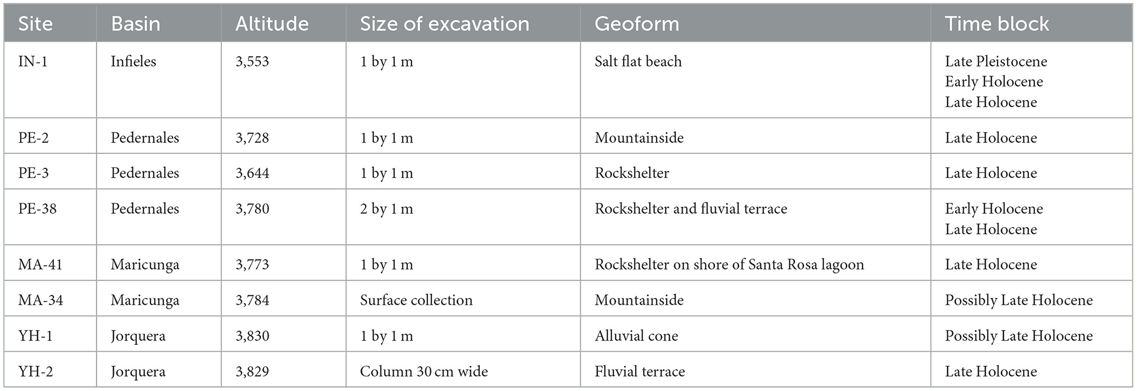
Table 1. Late Holocene archaeological sites in the study area.
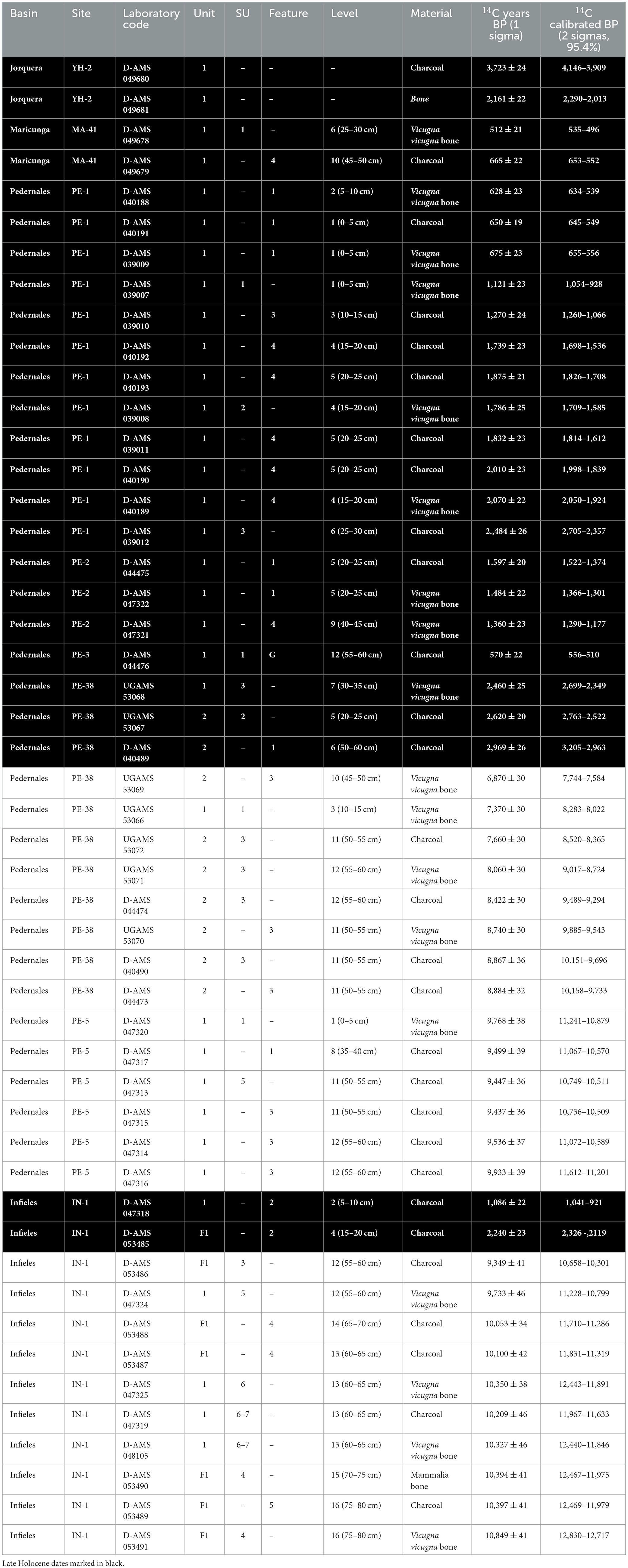
Table 2. Radiocarbon dates of the Infieles, Pedernales, Maricunga, and Jorquera sites during the Late Holocene.
Analysis of ceramic remains was based on macroscopic observation of the material noting the following variables: (a) superficial treatment, e.g., smooth, brushed or polished; (b) thickness of walls; (c) shapes, defining segments such as rim, neck and body; (d) firing, determined by categories such as absence and presence, as well as (c) complete or incomplete. The number of zooarchaeological remains is defined by the Number of Identified Specimens (NISP). Analysis of taxonomic abundance is calculated based on the Minimum Number of Individuals (MNI). The frequency of anatomical units was measured by the minimum number of skeletal elements (MNE), the Minimum Number of Animal Units (MAU) and the %MAU. We calculated the indices of Species Richness (NTaxa), Diversity (Shannon Index, H′) and Evenness (J′) in order to compare the sites from the whole cultural sequence of the basins studied. The last two indices were calculated by multiplying the MNI by the average weight of each taxon in life. The taxonomic categories of Mammalia, Rodentia and Aves were eliminated from the calculation due to the problems of quantifying fragments involving species of different sizes.
Lithic analysis focused on two sites, PE-38 and IN-1, as they contained the longest sequences found in any of the salt flats. The materials were separated into general technical classes (core, retouched tools, bifacial pieces, and knapping remains), and subdivided into specific typological groups. The following variables were then recorded: (a) class of rock and variety of raw material; (b) percentage of cortex in increasing intervals; (c) dimensions (length, width, thickness) and weight; (d) type of blank; (e) preparation procedure and knapping technique; (f) knapping accidents; (g) types of fracture; (h) intensity and extent of thermal alterations; (i) intensity and extent of abrasion. The knapping operational chains were reconstructed based on diacritical schemes of selected pieces. Knapping techniques were inferred from comparison with references pieces and the recognition of technical attributes proposed in experimental works (Pelegrin, 1995, 2000).
Spatial analysis focused on calculating the least-cost paths between various locations with archaeological evidences (Table 3), such as malacological remains, ceramic and rock art motifs, typological affinities and obsidian sources. The archaeological obsidian samples included are detailed in Supplementary material 1 and mainly consist of knapping remains; the samples from IN-1 and MA-34 were collected on the surface (Loyola et al., 2023). We used 15 locations and calculated 18 least-cost paths (Table 4). The optimum path calculation has been used in various studies (Herzog, 2010, 2021; White and Surface-Evans, 2014; Ciriglianoi and Palloii, 2016; Verhagen et al., 2019; Moreno-Meynard et al., 2022) and with different approaches. For this calculation, we used an anisotropic criterion, on the basis that human mobility and its cost vary in non-linear patterns, relating the energy consumed to the gradient of the slope, the soil type, etc. It is therefore irregular and inconstant (López Romero, 2005). Slope data were calculated from the dataset of the Shuttle Radar Topography Mission (NASA, 2013) with a resolution of 30 m, using QGIS software (QGIS Association, 2024). Cost estimation followed the Minetti (1995) function modified by Llobera and Sluckin (2007) and revised by Herzog (2014), considering the following symmetrical quadratic function:
Where š and s are the slope in percentage terms.
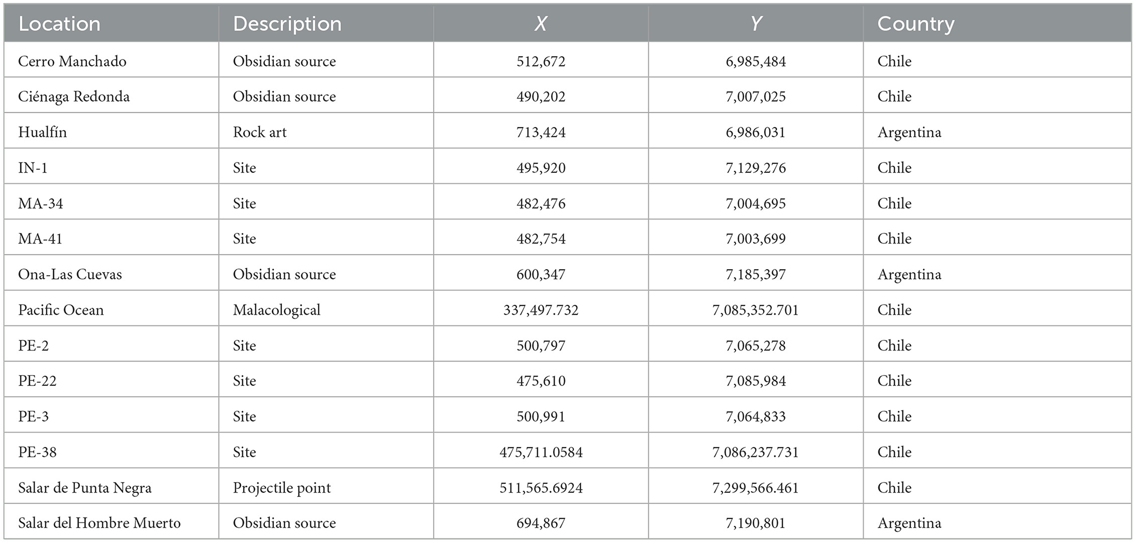
Table 3. Locations used to calculate least-cost paths.
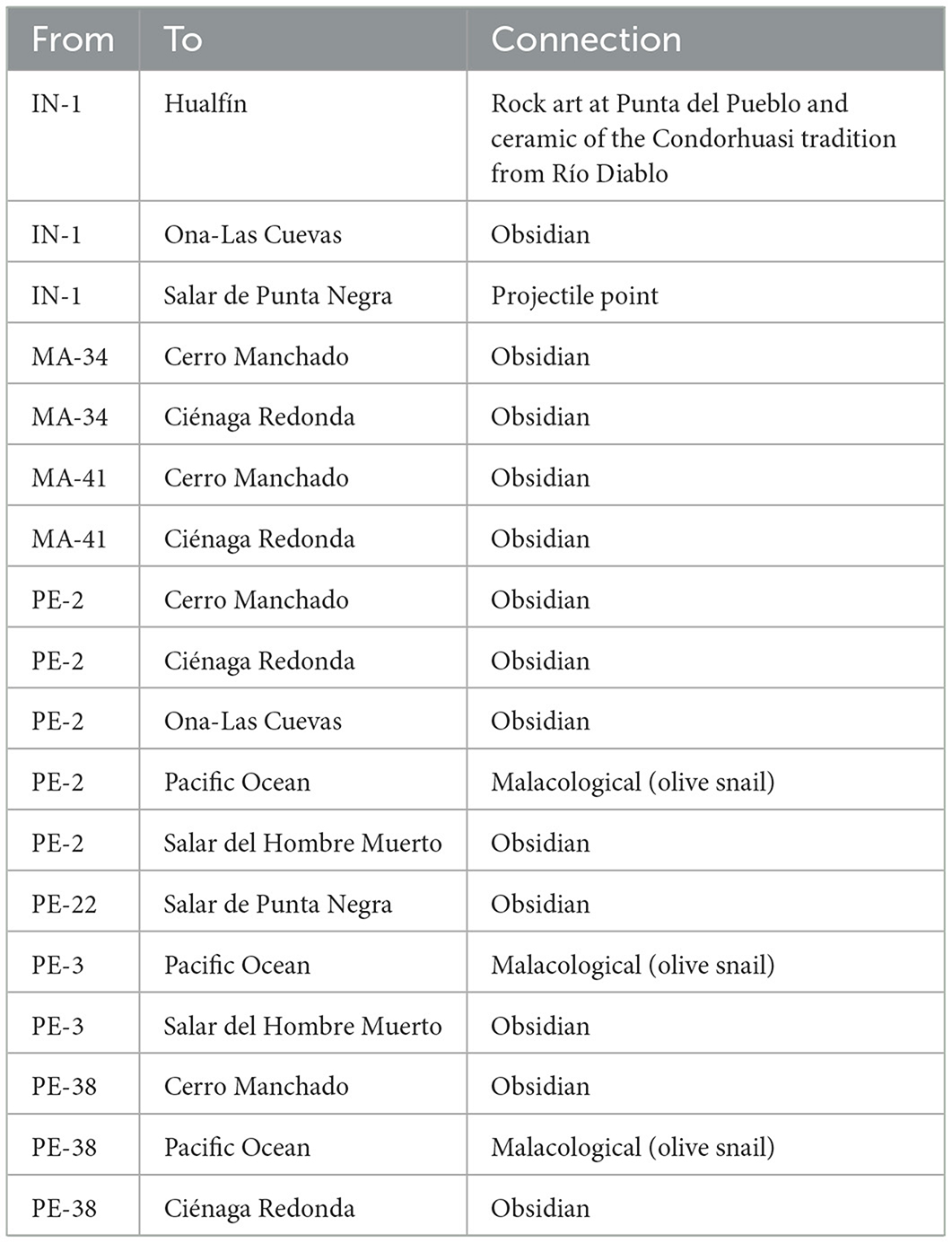
Table 4. Least-cost paths calculated and the hypothetical connection between the locations.
Apart from the gradient, we considered it important to include the possible cost of moving across different soil types; we therefore added the Land Use Registers for the Atacama Region (Corporación Nacional Forestal, 2019), the Antofagasta Region (Corporación Nacional Forestal, 2018), and Argentina (Volante et al., 2009).
A multiplication cost was assigned to the soil types present; in other words, for a soil type that presented no difficulty in crossing, the slope would be multiplied by 1; while for a high-cost type, such as crossing a lagoon, the slope would be multiplied by 10 (details available in Supplementary material 2a–c). We then added a border to the resulting raster with a cost value of 300 to increase the efficiency of the analysis and avoid errors of direction; finally, we calculated the least-cost path by Dijkstra's (1959) algorithm using the Least-Cost Path plug-in (Gooong, 2024).
5 Results
Our inter-disciplinary study involved chronological, paleoenvironmental, and different artifactual and ecofactual analyses of the evidence obtained. It is important to discuss the ecofactual evidence within a comparative framework including different periods. Data such as the origin of obsidian sources, ceramic types and their origin, rock art styles and other complementary evidence are also addressed, as they are basic information for calculating least-cost paths.
5.1 Zooarchaeology
The samples studied to calculate the NISP are detailed in Table 5, and for MNI in Supplementary material 3. Wild camelid hunting is undoubtedly one of the economic activities most frequently represented throughout the sequence. In almost all the sites, except PE-5, vicuña (Vicugna vicugna) is by far the preferred prey (Figure 3A). Although the NTaxa indicates that the numbers of some taxa decline toward the Late Holocene, the trend in the type of species is relatively similar from the Late Pleistocene and Early Holocene, considering the inclusion of remains by natural means, especially rodents (Cricetidae) and lizards (Liolaemus spp.) in sites located on blocks of ignimbrite like PE-5 and PE-38 (Table 5). This is reflected in the Diversity and Evenness indices, which present no remarkable changes over the whole sequence, considering that the greatest species diversity in the puna is found in birds, which are scarcely present in the archaeological record (Figure 3B).

Table 5. Taxonomic representation expressed in NISP for each site studied.
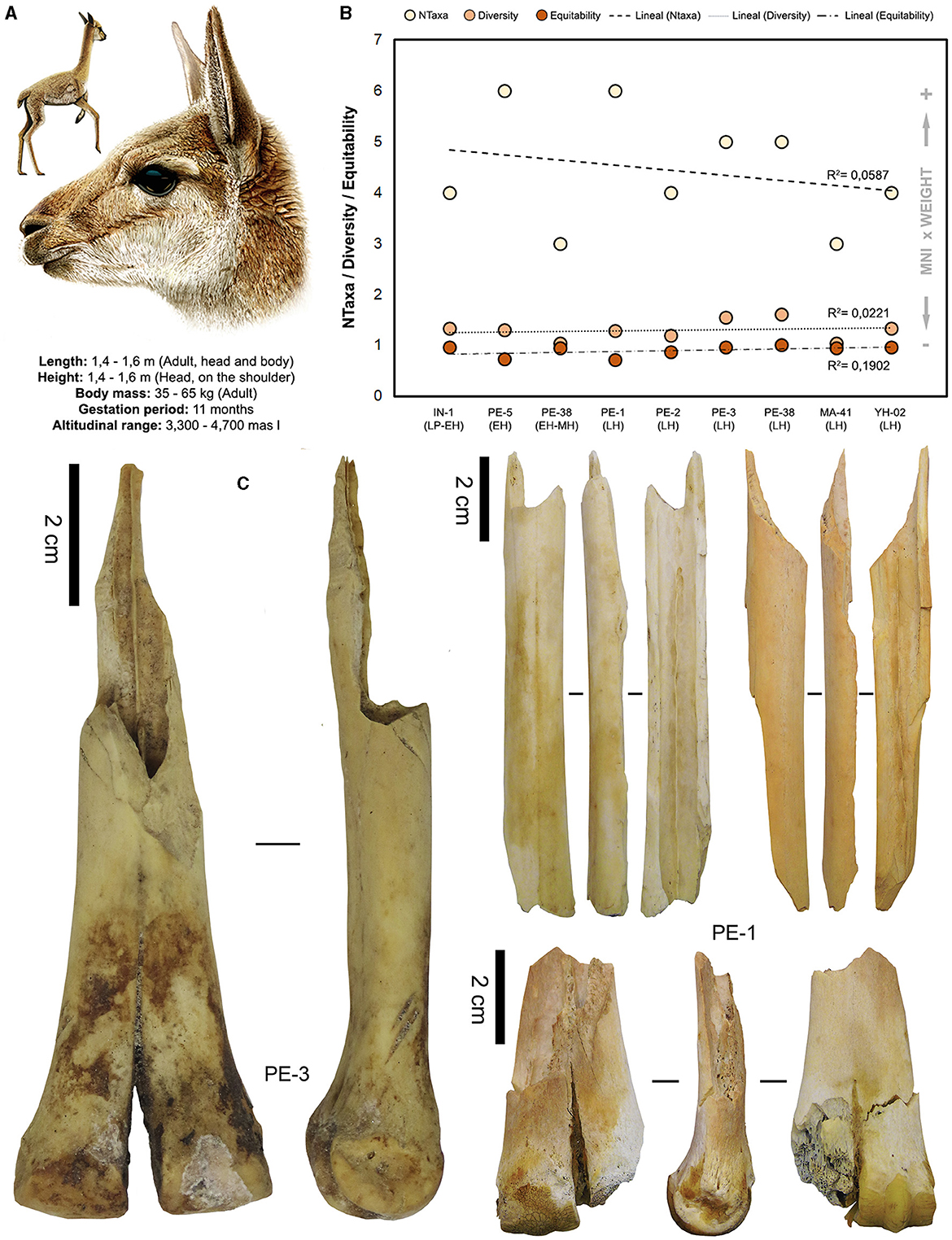
Figure 3. (A) General characteristics of Vicugna vicugna, (B) Indices: NTaxa, Diversity, and Evenness from the Late Pleistocene to the Late Holocene, and (C) remains of metapodial bones with signs of intentional fracture.
In previous works carried out in the study area we have discussed a series of expectations related to the use of logistical camps or residential base camps (López et al., 2021b). In logistical camps, the anatomical units represented should be low-yield units, with little bone fragmentation due to the transport of high-yield units to related sites located at other altitudes (Neme et al., 2020). In residential base camps, used over long periods, we would expect the animal bone remains to reflect the wide diversity of altitude environments available, with all anatomical units represented, and high bone fragmentation given the greater consumption of fat and marrow (Neme et al., 2020).
The frequency of bones in Early Holocene events is consistent with the expectations for logistical camps, while for later events (especially pottery-making groups), the similar frequency of bones from the skeletal axis and the appendices reflects a pattern consistent with residential bases used for long periods during summer seasons. Several remains of metapodial bones present signs of intentional breakage (Figure 3C). In both time blocks there are indicators of seasonal use, such as eggshells from Phoenicopteridae, which lay from December to March. These trends suggest summer use, around the time when vicuña young are born. However, a notable change in mobility occurs during the Late Holocene, indicating a shift to residential use.
5.2 Hunting structures
Other evidence related to camelid hunting in the area includes a series of structures used during hunting and carcass processing. These structures consist of trenches-shelters and work surfaces (see Moreno, 2010) for animal sighting, encounter hunting and carcass processing (Figure 4a). They are located principally on high ground in hilly areas and on flat ground close to stable settlements, or near movement routes and grazing grounds of vicuñas and guanacos, forming functionally complementary local systems (Figures 4b–e). Although there are few stratigraphic deposits in these sites, the surface evidence allows us to associate them with the Late Holocene, based on the presence of raw materials (high quality siliceous rocks) exclusive to this period detected stratigraphically. The structuring of this hunting landscape is evidence of a heavy investment of work, which over time would yield a high energy return (Aschero and Martínez, 2001; Moreno, 2010).
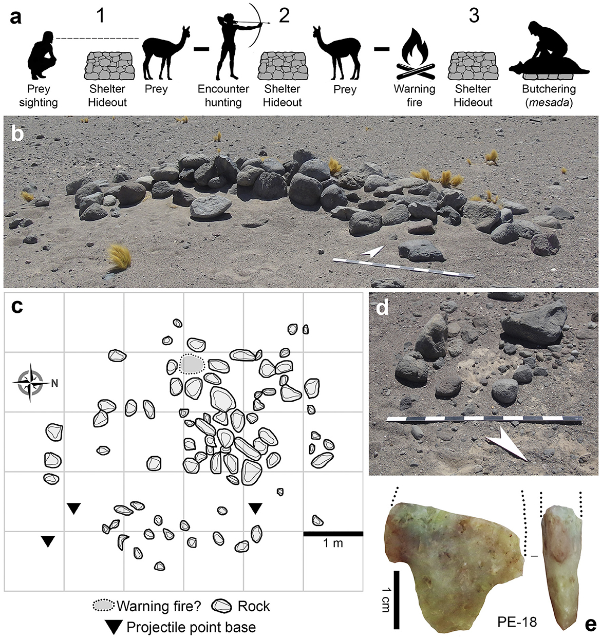
Figure 4. (a) Activities performed in the hunting structures: 1. Prey sighting, 2. Encounter hunting, and 3. Butchering, (b) shelter and trench in Salar de Pedernales, (c) possible work surface at site PE-18, (d) possible warning beacon at site PE-18, and (e) basal fragment of projectile point from PE-18.
5.3 Lithic technology and raw material procurement
Another strongly represented activity is lithic procurement and tool manufacture. Of the sites studied, we have lithic technology information only for PE-38 and IN-1. The lithic assemblage from PE-38 consists of 1,270 pieces, of which 345 date to the Late Holocene occupation between levels 3 and 7 (Figure 5A). Of this group, 88.41% are siliceous rocks; 71.30% are of a greenish, grained variety probably of local origin. The (much smaller) second-largest group consists of tuff (8.99%), and there are other minority rock types including obsidian from the Ciénaga Redonda-Cerro Manchado source 70 km further south, in the Salar de Maricunga (Loyola et al., 2023).
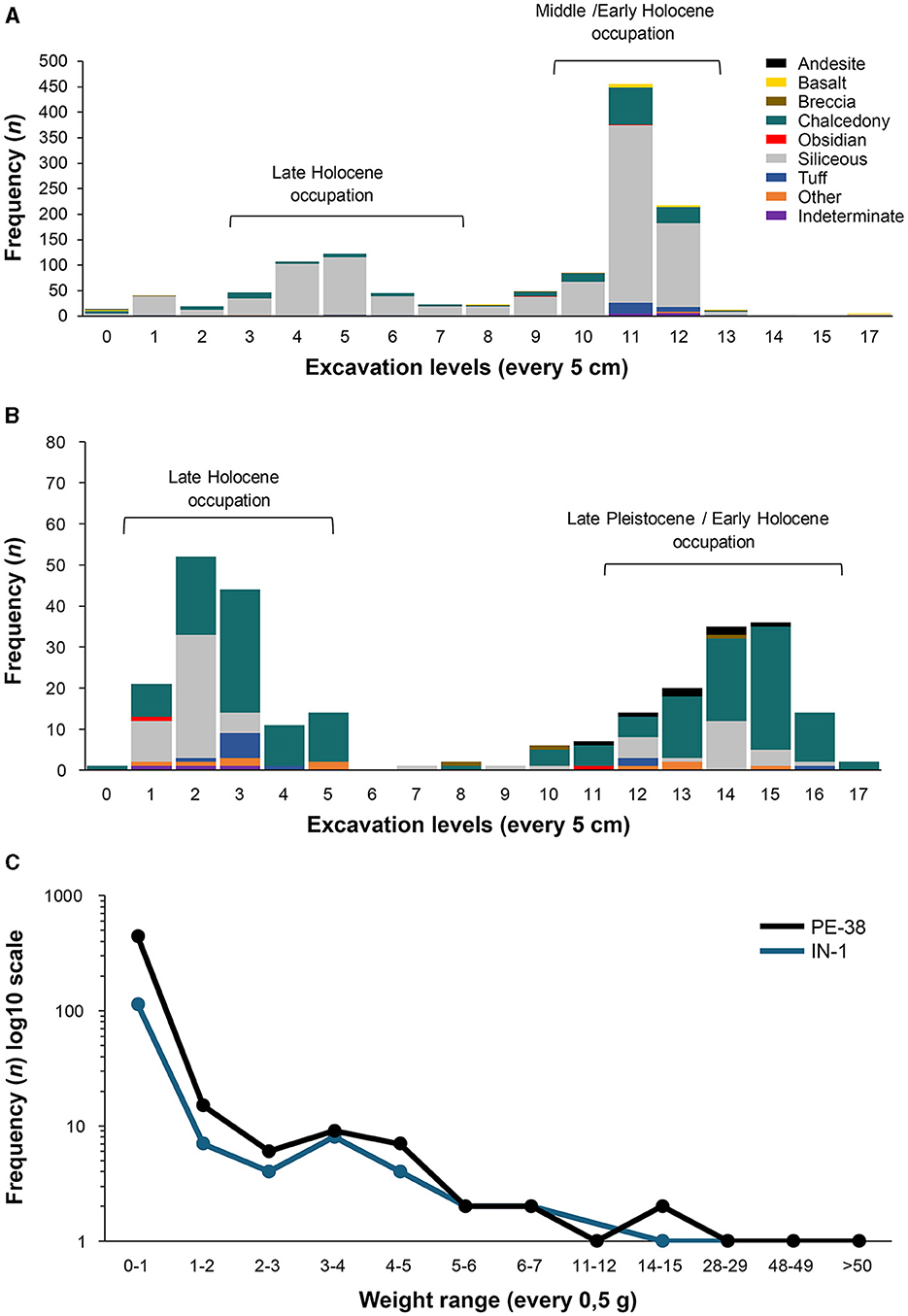
Figure 5. (A) Frequency of lithic pieces by level of excavation at PE-38, (B) frequency of lithic pieces by level of excavation at IN-1, and (C) distribution of lithic pieces by weight bands.
The sample consists mainly of non-diagnostic knapping remains (Table 6). There are a few flakes from advanced bifacial shaping (n = 22) and pressure knapping (n = 15), related to projectile point manufacture. Other pieces, like a retouch flake of a unifacial tool and a circular end-scraper with indications of re-sharpening (Supplementary material 4a), suggest to a lesser degree the production and use of retouched tools (Loyola et al., 2024). Immunological studies of remains adhering to the edge of the scraper showed a positive reaction with camelid antiserum (vicuña), suggesting that it was used for processing skins (Loyola et al., 2024). There is practically no evidence of débitage.
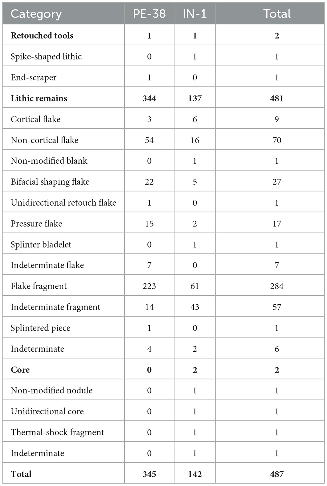
Table 6. Technological classes of the lithic assemblages.
The majority of the non-diagnostic knapping remains fall into groups of small size and low weight, confirming that the final stages of the operative chains for the manufacture of unifacial and bifacial tools were performed at the site. All this suggests that the tools entered the settlement already finished, or at least as preforms and blanks to be used, maintained and exported at the end of occupation; in some cases, the tools were discarded in the site. These trends agree with the expected activities of a short-stay hunting camp in the highlands during the Late Archaic Period, probably occupied during the summer by task-groups.
The IN-1 assemblage consists of 281 pieces, of which 142 come from levels 3 to 7. These levels contain dates from the Late Holocene. The predominant rocks in this group are chalcedony (55.63%) and siliceous rocks (31.69%) (Figure 5B). Both raw materials form part of the same outcrop located in the neighborhood of the site (López et al., 2024). This is reflected in the presence of evidence of débitage and cortex removal on small fragments at the site (Table 6). At least one nodule of raw material, a re-worked unidirectional core (Supplementary material 4b), and one unmodified blank were left in the site. Cortex flakes are more frequent, while the knapping remains falls into groups of large size and weight (Figure 5C). Some flakes (n = 5) from bifacial shaping obtained by soft-tangential percussion—and probably one pressure flake—suggest moderate work on bifacial tools. From this stratigraphic unit we also recovered an exceptional obsidian piece in the form of a six-pointed “spike” (Supplementary material 4c). The piece was worked using a non-cortical flake as blank and was pressure-retouched bifacially by means of short, sub-parallel flakes. Although it might be a projectile point, the plane-convex section and the morphology appear to indicate an ornamental object. The lithic record agrees with the previous interpretation of the Late Holocene occupation as a temporary camp used by caravans and/or foot travelers when crossing the Andes during the Middle and Late Intermediate Periods; they also would have taken the opportunity to collect workable rocks as well as pigment used in the rock art at the site.
Retouched tools are scarce in the Late Holocene levels. However, surface finds of these and other types in the study area indicate a great typological diversity in projectile points during this period. In PE-38, several small and medium-sized stemmed projectile points were recorded (Figure 6A) which present dimensional and technological differences from the points known for the Early Holocene in the site (Loyola et al., 2024). In IN-1, a stemmed projectile point with triangular blade, wings and contracted stem was recovered on the surface (Figure 6B). The volume had not been thinned and it was only lightly retouched, which would appear to suggest a simplified variant. Other stemmed projectile points with wings and contracted stem were recorded in association with hunting structures in the upper part of the Pedernales basin (Figure 6C). In PE-3, triangular projectile points were recovered—both stemmed and non-stemmed—which were probably used in bow and arrow systems in later periods (Figure 6D). In the adjacent PE-2 site, we also documented a non-stemmed projectile point dated to the Late Intermediate Period (Figure 6E). In YH-2, we recorded stemmed (Figure 6F) and triangular non-stemmed points (Figures 6G, H) dated to the Late Holocene. Grinding instruments are also frequent in several of the sites investigated, which probably indicates the importance of plant resources in the highlands.
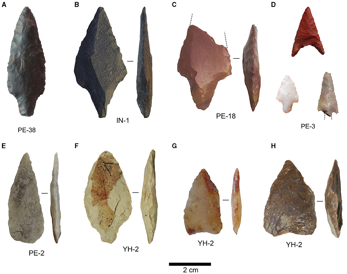
Figure 6. Types of projectile points and bifaces recorded in the basins studied: (A) PE-38, (B) IN-1, (C) PE-18, (D) PE-3, (E) PE-2, and (F–H) YH-2.
To analyze the origin of the obsidian pieces used as references in the least-cost path analyses, we included 46 archaeological samples analyzed in previous works. Of these, 29 come from the Cerro Manchado-Ciénaga Redonda source (Salar de Maricunga), 11 from Ona-Las Cuevas and four from the Salar del Hombre Muerto (Catamarca, NWA); the last two samples are unassigned (Supplementary material 5).
5.4 Ceramics
The fragments recovered at IN-1 belong to one or two similar vessels, of restricted compound profile, with thin walls, polished exterior and smooth interior. The exterior decoration is incised in dotted fields with traces of red pigment, delimited by straight lines, which indicate a link with the Río Diablo phase of the Condorhuasi tradition of NWA (González et al., 2023. Figures 7a, b). Other evidence comes from site PE-2. This site contains smooth, restricted vessels with a neck, and rim diameter of around 200 mm; vessels with polished exterior; and smooth, thin-walled vessels, possibly restricted, with clays containing large and very large inclusions. All the fragments are monochrome and present no diagnostic decorations or shapes (Figures 7c–e). On the surface we observed fragments from the Inka tradition with decoration in black and red on white slip (Figure 7f), and a gray fragment with incised decoration which could belong to the Historical period (Figure 7g). In the adjacent site, PE-3, three types were recorded: restricted vessels of polished exterior, with inflected profile, short neck and strongly everted rim; non-restricted vessels, highly polished on both faces; and restricted vessels with inflected profile, smooth on both faces and clay containing mica as an anti-plastic, suggesting that they may belong to Atacameño ethnographic types (Uribe, 2004; Figures 7h–l). Finally, in YH-1 a fragment was found of a non-restricted vessel, polished on both faces with decoration in black on red slip, assignable to a bowl of the Copiapó black on red type (Garrido, 2004), which suggests links with local lowland groups (see Table 7).
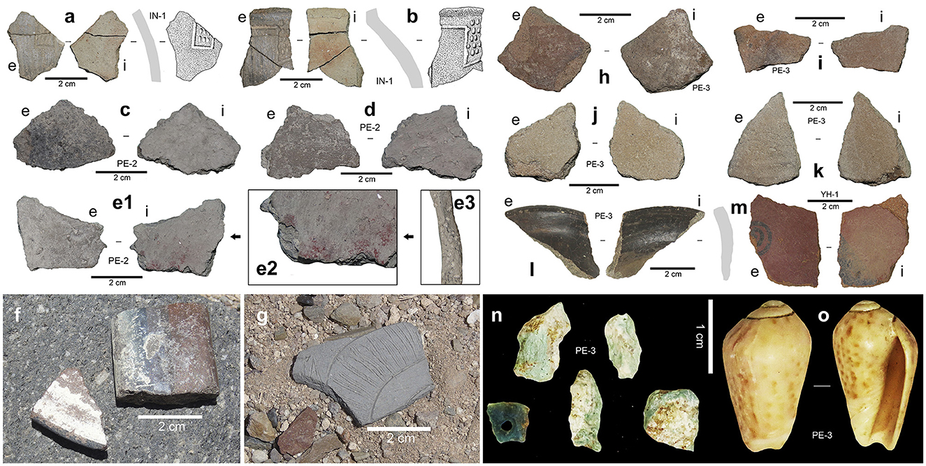
Figure 7. (a, b) Ceramic fragments from IN-1 ascribed to the Río Diablo phase, (c–e1) monochrome fragments from PE-2, (e2) detail of red pigment, and (e3) cross section, (f) fragment of Inka ceramic from PE-2, (g) incised fragment, possibly Historical, from PE-2, (h–l) ceramic fragments from PE-3, (m) Copiapó type fragment from YH-1, (n) mineralized copper including a collar-bead pre-form from site PE-3, and (o) Felicioliva peruviana from site PE-3.
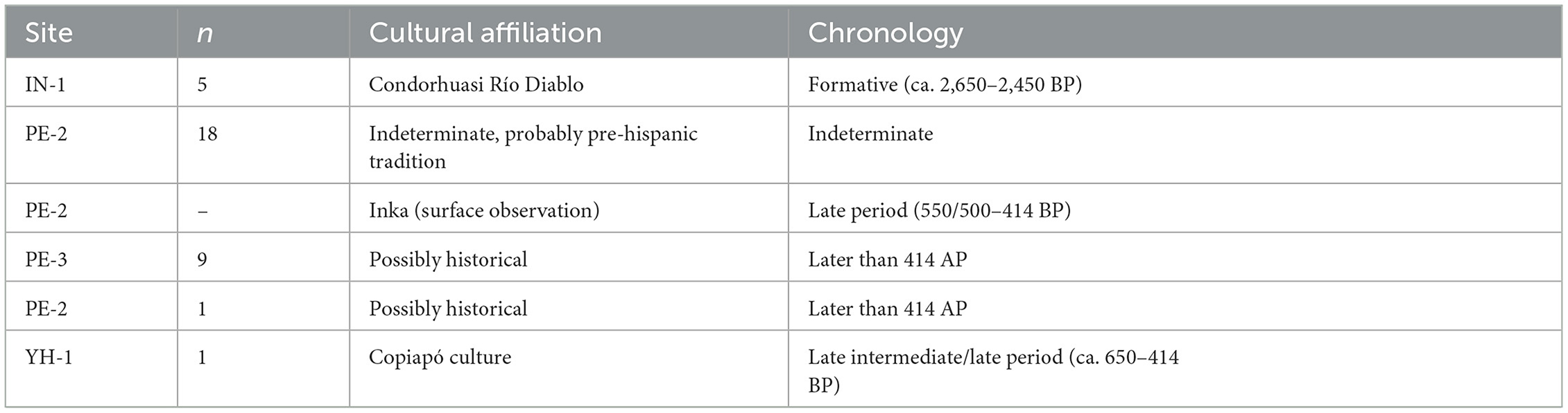
Table 7. Detail of the ceramic remains found in Infieles (IN), Pedernales (PE) and Jorquera (YH), together with their cultural ascription and chronology.
5.5 Production and circulation of personal adornments
In sites such as PE-2 and PE-3, remains of copper ore were recovered. This can be associated with bead production (Figure 7n), although not on the same scale as in the areas where mass production occurred, like the surroundings of Mina Las Turquesas, exploited from the Formative Period (ca. 3,150–1,350 BP) to the Late Period (ca. 550–414 BP) (González et al., 2017). This production is limited compared with that of these big production areas and is presumably related to the availability of veins of copper ore in the area. It is interesting that remains of Felicioliva peruviana (olive snail) have been recovered in stratigraphy at sites like PE-3 and observed on the surface at PE-2 and other Pedernales sites of similar characteristics (Figure 7o). This species is distributed in the Pacific Ocean from Sechura, Peru (5°S) to Concepción, Chile (36°S), and today is not considered edible (Osorio, 2002). It has been reported in archaeological sites in Peru, Bolivia, northern Chile and NWA. The samples from Argentina, from the Province of Córdoba (32°S), are observed to have no apex, and signs of abrasion on their ventral face, suggesting an oval outline (Gordillo, 2021). In northern Chile, this species is associated with a long temporal range, being mentioned for Arica (18°S) in a funerary context from the start of the Holocene (Núñez and Santoro, 1988). In the Caserones site (19°S), we find mention of shells of this species without apex and with an orifice close to the valve opening (True, 1980; Valenzuela, 2010); likewise in a caravan camp dated to 2,870–2,140 BP, together with remains of mineralized copper in the upper Loa (21°S), for use as an adornment (Soto, 2019); and in Archaic sites (4,950–3,950 BP) of the circumpuna highlands such as Puripica, Tambillo, and Tulán (22°-23°S, Núñez, 1984; Soto, 2009; Núñez et al., 2017), among other references.
5.6 Rock art
In Infieles we find a remarkable record of rock paintings and carvings, both pre-Hispanic and Historical, the former including both non-figurative (lines, rectangles, ovals, triangles, irregular forms), and figurative designs (anthropomorphic and zoomorphic, see Supplementary material 6). These rock paintings represent styles associated with Punta del Pueblo in Antofagasta de la Sierra (1,450–950 BP), typical of NWA; Las Ánimas motifs (1,450–950 BP); the Late Intermediate/Late Period (950–414 BP) based on rock-art styles from the northern and central parts of the Atacama Region (González et al., 2023).
The representations associated with Punta del Pueblo are linked to caravan groups from Antofagasta de la Sierra, reflecting possible ceremonial activities at the site, as indicated by Martel et al. (2017, p. 200) in trans-Andean contexts. Records of Condorhuasi-Río Diablo ceramic recovered from a pre-Inka travel route site in Pampa del Carrizo (near Infieles) support a relation between this ceramic and evidence of caravan groups who used this salt flat throughout their continuous movements (González et al., 2023).
5.7 Integrating the information: spatial analysis and inter-regional connection
Based on the multiple types of evidence recovered and described above, integration of the information and application of spatial analysis enabled us to calculate successfully 18 least-cost paths (Figures 8a, b), showing paths indicating high interconnectivity between sites. At a first level of analysis, we may consider that circulation paths existed from and between the salt flats of the puna during the Late Holocene, providing interconnections between points on the west or Pacific slope and coast, and the intermediate sectors of Argentina. The Infieles, Pedernales, and Maricunga salt flats present spatial configurations that favor circulation paths, as has been shown by other lines of evidence (see Supplementary material 7–13).
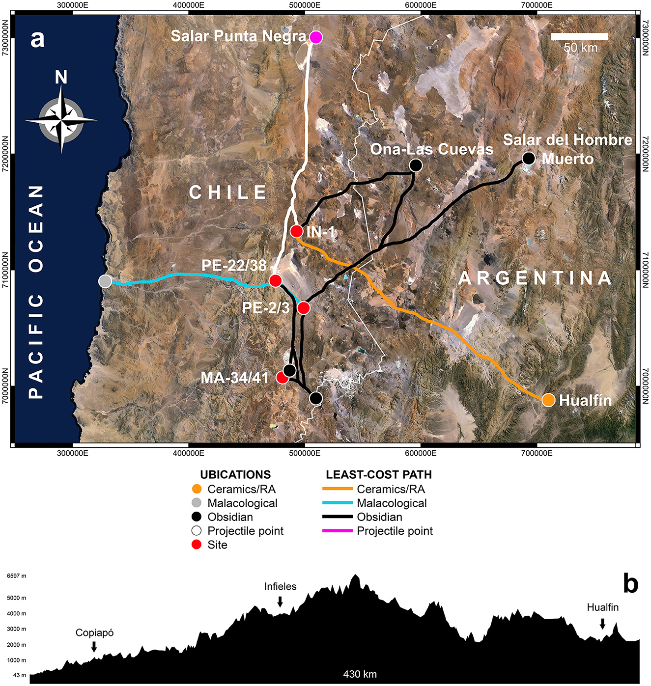
Figure 8. (a) Map of least-cost paths by location and link, (b) section of the study area.
The novel aspect of this work is the finding that the paths are superimposed, with the same path used from different starting points. This is the case of the best paths from PE-2 and PE-3, and from PE-38 to the Pacific, which, although the starting points are more than 32 km apart, both follow the course of the Salado river. Furthermore, to reach the start of the climb up the Cuesta Montandón from PE-2 and PE-3, the path necessarily passes by the path to PE-38 and PE-22. The Cerro Manchado obsidian source is more difficult to reach than the relatively nearby Ciénaga Redonda, due to its high altitude and the need to climb up toward Los Patos volcano (see Loyola et al., 2023). It therefore appears more probable, given the similarity between the sources, that Ciénaga Redonda is the optimum procurement point. Whatever the case in this respect, it is clear that a north-south path interconnected the sites from PE-38 in the north, passing close by PE-2 and PE-3, and then separating, with a second southward path diverging to the east. Thus, a path to the obsidian sources could be posited passing along the edge of the Salar de Maricunga, joining sites MA-34 and MA-41, which would at the same time provide easy access to raw materials and other spaces offering high availability of resources and shelter.
The access paths to the raw material sources of Ona-Las Cuevas from sites IN-1 and PE-2 differ completely. From IN-1, passing through Salar de Aguilar and then Salar de la Isla, a direct crossing through the mountains is established at the latitude of Laguna Aguas Calientes, passing subsequently through Laguna Los Patos. From PE-2, on the other hand, the path would cross Salar de Piedra Parada in an easterly direction, reaching the frontier almost level with Laguna Brava Norte, and then deviating northwards close to Salar del León Muerto. From there, the path continues to the north-east, passing between Salinas del Fraile to the east and Laguna Vega Larga to the west, to reach a number of small lakes such as Laguna Cajeros and joining the path from IN-1 between Cerro Los Patos and Cerro Lila. The path to Salar del Hombre Muerto from PE-3 and PE-2 is exactly the same as the path to Ona-Las Cuevas; however, it diverges at the level of Volcán Colorados, heading north-east across the Salar de Antofalla, and then passing Laguna de Caro to reach the source of materials at Laguna del Hombre Muerto.
In the case of the paths from IN-1 and PE-2 to Ona-Las Cuevas, and from PE-3 and PE-2 to Salar del Hombre Muerto, we observe that they offer direct, safe connection along mobility circuits very well-supplied with water and local flora and fauna. The route from site PE-2 to Salar de Punta Negra might appear difficult, however the least-cost path climbs to the north along the edge of Pedernales to the lower part of Cerro Bolsón, where it joins the path from IN-1. From there it turns north, passing close by Salar de Aguilar, then Salar de Agua Amarga and finally Salar de Pajonales, which leads directly to Salar de Punta Negra. This path is quite interesting, since the accumulated cost analyses show that it has the highest cost per km. Nevertheless, it supports the thesis of interregional mobility in areas close to reliable fauna and plant resources. Finally, the longest and most improbable path is that connecting site IN-1 with the area of Hualfín, a distance of 293.33 km. The path leads south-east, bordering Infieles, though a number of ravines until it comes close to Lagunas Bravas. There it crosses into modern-day Argentina, where it connects with the system of streams and rivers fed by snow-melt, between Manantiales and Bayo mountains. This connects in turn with the area of high Andean and Puna lakes including Laguna del Peinado, Laguna Purolla and Mar de Olas, east of Robledo volcano. This route continues past the lakes at the foot of Cerro Pabellón to Río Belén, and finally reaches Hualfín.
6 Discussion
The results of our research take us in three directions. In first place, the arid event of the Middle Holocene had a significant impact on human mobility, which was manifested in a low to null archaeological signal between 7,600 and 4,000 cal. years BP. The second refers to the fact that the repopulation of the area during the Late Holocene coincides with an improvement in environmental conditions ~3,000 years ago. In the third place, during later agro-ceramic periods, a more significant and diverse occupation of the environments was experienced, consolidating niche construction. The drastic hiatus in occupation of the Puna de Copiapó between 7,600 and 4,000 cal. BP coincides with the so-called “Archaeological Silence” proposed for the Atacama puna (Núñez and Santoro, 1988). This drastic drop in the archaeological signal is probably related with the hyper-arid conditions established during the Middle Holocene in the Atacama basin and other areas of the Central-Southern Andes.
Some authors have attributed this phenomenon to a demographic bottle-neck (Barberena et al., 2017). It is of course probable that the drop of the archaeological signal in the Southern Puna is not due to a total absence of human occupations, but to the reduced visibility and representativeness of the record, because the Puna was probably occupied intermittently during the Middle Holocene. In other regions less affected by arid conditions, the formation of micro-environments supported habitats favorable to human life, known as “eco-refuges,” which meant a reorganization of human settlement and mobility (Núñez, 1992; De Souza, 2004; Yacobaccio and Morales, 2005; Pintar, 2009; Aschero and Hocsman, 2011; Núñez et al., 2018). A similar situation may have occurred in particular areas of the Southern Puna which have not yet been identified. The reappearance of the archaeological signal at the start of the Late Holocene is quite subtle, limited to two events, first in YH-2 and then in PE-38, which present low density of material. This may reflect the fact that the recovery of humidity and the formation of productive environments in the highlands at the beginning of the Late Holocene was quite gradual (Grosjean et al., 1997; Maldonado and Rozas, 2008; Maldonado et al., 2016). Thus practices such as seasonal mobility toward higher altitude areas would have become established progressively, as was observed during the Early Holocene.
After 2,000 cal. years BP, the archaeological signal increases considerably, both in the density and number of occupations, as well as in the types of sites, reflecting a diversification in modalities of occupation and land-use. The best represented activities are camelid hunting and plant gathering. The hunting structures and landscapes also indicate that the capture of vicuña and guanacos was an important activity during the Late Holocene, suggesting intensification in the exploitation and construction of a specific niche (Zedeño et al., 2014; Lemke, 2021). Planning and the use of structures would also require co-operation, and the mobilization of collective work, associated with emerging social complexity. The great diversity of projectile points indicates that this activity was important in different periods, probably implying different hunting strategies and weapon systems. These spaces also appear to have been important for plant gathering, as confirmed by finds of grinding tools in YH-2, PE-2, and IN-1. Archaeobotanical analyses carried out in the Late Holocene levels of PE-38 indicate access not only to zonal vegetation but also to azonal species in lakes and wetlands, reflecting the increased diversity of taxa used as compared to the Early Holocene. Similar tendencies are found in sites on the eastern slope of the Andes, as a result of increasing appropriation of the landscape (Rodríguez and Aguirre, 2019).
With the occupation of groups that manufactured pottery, other forms of land use in highlands areas start to appear. In various sectors of the marshes formed by the Juncalito river we have documented land and corrals used for animals, with deposits of fecal remains; these marshes would therefore have been used as foraging areas, probably as part of transhumantic grazing circuits. Moreover, sites like PE-38 and IN-1 were evidently used during visits to sources of rocks and minerals. Notable among the latter is a pigment, easily available in the vicinity, which was used profusely in rock paintings. Other sites, like MA-41 in the Maricunga basin, show local exploitation of black obsidian from the Ciénaga Redonda-Cerro Manchado source (Loyola et al., 2023), while remains of mineralized copper were recovered from sites PE-2 and PE-3. Copper production was fairly limited, so this might be connected with small-scale local exploitation of veins of copper ore.
The analyses of least-cost paths between the various sites suggest an interconnected space between the mobility routes of the human groups. They establish clearly the possibility of north-south traffic from Salar de Punta Negra in the north to Salar de Maricunga in the far south, as well as east-west movement between the Pacific coast and NWA. It is interesting to note that all the optimum paths observed pass through areas of wetlands, bogs, salt flats and lakes, considered a crucial factor in extensive, large-scale mobility circuits. This is corroborated by various materials like the Felicioliva peruviana shells at sites PE-2 and PE-3, connected by the path with PE-38 where materials associated with the Huentelauquén Cultural Complex were recorded (López et al., 2022). The same occurs with the paths to spaces from which obsidian was obtained, or the area of Hualfín where ceramic of the Condorhuasi-Río Diablo type was found, or the Punta del Pueblo style rock art. To corroborate these exploratory ideas, it will be necessary to look for archaeological sites in the areas indicated by the least-cost paths, a line of exploration which offers high possibilities of success. At the same time, it is also necessary to evaluate the spatial interconnectivity of the region as a whole, not only the links between different locations, and taking other elements of human agency into account as well as the least cost.
7 Conclusions
In conclusion, the research carried out in the Southern Puna indicates an almost total absence of occupations between 3,200 and 7,500 cal. years BP, with the exception of a date of 4,146–3,909 cal. years BP in the Jorquera River. These results confirm that the arid event of the Middle Holocene did indeed have a significant impact on the low archaeological signal between 7,500 and 4,000 cal. years BP. As environmental conditions became more humid, the Puna de Atacama was re-occupied by hunter-gatherer groups, although with low-intensity occupations until the appearance of the first records of pottery makers. This may be attributable to the gradual rate of repopulation from 3,200 cal. years BP, due to the alternation of arid and humid phases (Maldonado et al., 2016).
It is from the appearance of ceramic groups that a greater intensification in the occupation of space is observed, but also a greater diversification of the interests linked to the use of these high Andean environments. To date our excavations in sites from late periods are scarce, but surface finds associated with corrals, structures and rock-art denote that these spaces were occupied by herders. For now, we cannot confirm or dismiss that this process of domestication was local, as occurred in the Salar de Atacama (Núñez et al., 1999). We have not identified environmentally stable eco-refuges that would allow local camelid domestication practices as observed in the Salar de Atacama. In any case, the consolidation of pastoral practices allowed connections between very distant areas through caravan movement and the exchange of goods, as observed in many other regions of the Andes (Nielsen, 1997–1988). In the case of the Puna de Atacama, these goods include obsidian, minerals (especially copper), mineral pigment, and high-quality fibers such as those provided by vicuñas, and to a lesser extent by guanaco, which were abundant in the Puna de Copiapó.
Finally, the archaeological evidence does not fully fit the chronological and cultural sequences defined for the valleys and coast of the current Atacama Region. The Puna functioned as a series of nodes and internodes related mainly to high mountain basins and passes, and to a lesser extent to valleys and the Pacific coast. The construction of chrono-cultural sequences must therefore consider these cultural interactions, especially with NWA, given the presence of Condorhuasi Río Diablo ceramics, Punta del Pueblo rock art from Antofagasta de la Sierra and obsidian from the Ona-Las Cuevas and Salar del Hombre Muerto in Catamarca. The above goes hand in hand with the idea that important nodes can develop in hostile or scarcely productive areas such as the mountains, with strong contrasts in the density of activities and interactions (Nielsen, 2017) and related to a series of internodes re-used over time. Another scenario is the transition from an internode to a node or vice versa, especially in productive areas where exploitation is intensifying. An example of this for the study area is the Las Turquesas mine, located 30 kilometers west of Pedernales, where extraction passes from the hands of formative Atacameño groups to bearers of Ánimas ceramics during the Middle Period, but returns to Atacameño control in the Late Intermediate Period and subsequently into the hands of the Inka (González et al., 2017). At this point, it is worth asking whether activities as common—throughout the Puna de Atacama sequence—as vicuña hunting are merely due to a need for food and technology. We believe not, since various tasks, motives and forms of appropriation of space are represented in addition to obtaining resources. In this sense, the classic presumption that the Puna was visited exclusively for economic reasons is reductionist and must be discussed from various lines of evidence and approaches.
Data availability statement
The original contributions presented in the study are included in the article/Supplementary material, further inquiries can be directed to the corresponding author
Ethics statement
The research with archaeological evidence was approved by the National Monuments Council of Chile (Consejo de Monumentos Nacionales, Chile). The study was conducted in accordance with the local legislation and institutional requirements.
Author contributions
PL: Conceptualization, Data curation, Formal analysis, Funding acquisition, Investigation, Methodology, Project administration, Resources, Software, Supervision, Validation, Visualization, Writing – original draft, Writing – review & editing. RL: Writing – review & editing, Conceptualization, Data curation, Formal analysis, Funding acquisition, Investigation, Methodology, Project administration, Resources, Software, Supervision, Validation, Visualization, Writing – original draft. CC: Writing – original draft, Writing – review & editing, Conceptualization, Data curation, Formal analysis, Funding acquisition, Investigation, Methodology, Project administration, Resources, Software, Supervision, Validation, Visualization. EL: Writing – original draft, Writing – review & editing, Conceptualization, Data curation, Formal analysis, Funding acquisition, Investigation, Methodology, Project administration, Resources, Software, Supervision, Validation, Visualization. VM: Writing – original draft, Writing – review & editing, Conceptualization, Data curation, Formal analysis, Funding acquisition, Investigation, Methodology, Project administration, Resources, Software, Supervision, Validation, Visualization.
Funding
The author(s) declare financial support was received for the research, authorship, and/or publication of this article. This work was financed by Agencia Nacional de Investigación y Desarrollo (ANID) through Fondecyt Projects 1190197 and 1240193.
Acknowledgments
We wish to thank the whole team who took part in the processes of excavation and analysis of the archaeological evidence: Luciana Quiroz, Pablo Díaz-Jarufe, Pablo Mariani, Ariel Sperling, Francisca Vera, Francisca Santana-Sagredo, Daniel Varas, Alethia Quirgas, Daniel Hernández, Angélica Soto, Valentina Flores-Aqueveque, Antonio Maldonado, Diego Mayorga, Josefina de la Barra, Vanessa Orrego, and Bárbara Neumann. Finally, we thank our colleague Daniel Pavlovic for his help in the assignation of some of the ceramic fragments.
Conflict of interest
The authors declare that the research was conducted in the absence of any commercial or financial relationships that could be construed as a potential conflict of interest.
Publisher's note
All claims expressed in this article are solely those of the authors and do not necessarily represent those of their affiliated organizations, or those of the publisher, the editors and the reviewers. Any product that may be evaluated in this article, or claim that may be made by its manufacturer, is not guaranteed or endorsed by the publisher.
Supplementary material
The Supplementary Material for this article can be found online at: https://www.frontiersin.org/articles/10.3389/fearc.2024.1423960/full#supplementary-material
References
Aldenderfer, M. (2011). Peopling the Tibetan plateau: insights from archaeology. High Alt. Med. Biol. 12, 141–147. doi: 10.1089/ham.2010.1094
Aschero, C., and Hocsman, S. (2011). Arqueología de las ocupaciones cazadoras-recolectoras de fines del Holoceno Medio de Antofagasta de la Sierra (Puna Meridional Argentina). Chungara 43, 393–411. doi: 10.4067/S0717-73562011000300005
Aschero, C., and Martínez, J. (2001). Técnicas de caza en Antofagasta de la Sierra, Puna Meridional Argentina. Rel. Soc. Arg. Antrop. XXVI, 215–241.
Barberena, R., Méndez, C., and de Porras, M. E. (2017). Zooming out from archaeological discontinuities: the meaning of mid-Holocene temporal troughs in South American deserts. J. Anthropol. Archaeol. 46, 68–81. doi: 10.1016/j.jaa.2016.07.003
Barton, L. (2016). The cultural context of biological adaptation to high elevation Tibet. Archaeol. Res. Asia 5, 4–11. doi: 10.1016/j.ara.2016.01.001
Borrero, L. A., and Santoro, C. (2022). Metapopulation processes in the long-term colonization of the andean highlands in South America. J. World Prehist. 35, 135–162. doi: 10.1007/s10963-022-09167-x
Brantingham, P. J., Xing, G., Madsen, D. B., Rhode, D., Perreault, C.h., van der Woerd, J., et al. (2013). Late occupation of the high-elevation northern Tibetan Plateau based on cosmogenic, luminescence, and radiocarbon ages. Geoarchaeology 28, 413–431. doi: 10.1002/gea.21448
Bravo, G. (2022). Redécouvrir le site de Bahía Maldonado (27°S): une première approche des chasseurs-cueilleurs archaïques du secteur septentrional de la région semi-aride du Chili. Antipodes Ann. Fond. Martine Aublet. doi: 10.48728/antipodes.220117
Cabello, G., González, C., and Garrido, F. (2010). “Revisitando la secuencia cronológico cultural de la Región de Atacama” in Identidades en Diálogo: Articulando Actores y Construyendo Realidades. Estudio fortalecimiento de la identidad regional de Atacama, ed. M. Lorca (Santiago: Centro de Estudios Avanzados en Zonas Árida), 31–49.
Capriles, J., Albarracin-Jordan, J., Lombardo, U., Osorio, D., Maley, B., Goldstein, S., et al. (2016). High-altitude adaptation and late Pleistocene foraging in the Bolivian Andes. J. Archaeol. Sci. Rep. 6, 463–474. doi: 10.1016/j.jasrep.2016.03.006
Cervellino, M. (1998). “El Período Arcaico en la Región de Atacama. Caza-Recolección y Pesca Marítima (9000 años a 100 años Antes de Cristo),” in Culturas Prehistóricas de Copiapó, eds. H. Niemeyer, M. Cervellino, and G. Castillo (Copiapó: Museo Regional de Atacama), 39–60.
Ciriglianoi, N. A., and Palloii, M. C. (2016). Entre caminos y equinos: un modelo SIG para localizar sitios arqueológicos de momentos históricos ecuestres (Provincia de Santa Cruz, Argentina). Rev. Chil. Antropol. 32, 89–101. doi: 10.5354/0719-1472.2015.42502
Corporación Nacional Forestal (2018). Catastro y actualización de los recursos vegetacionales y uso de la tierra de la Región de Atacama (III). CONAF. Available online at: https://ide.minagri.gob.cl/geoweb/2019/11/22/planificacion-catastral/ (accessed March 23, 2024).
Corporación Nacional Forestal (2019). Catastro y actualización de los recursos vegetacionales y uso de la tierra de la Región de Antofagasta (II). CONAF. Available online at: https://ide.minagri.gob.cl/geoweb/2019/11/22/planificacion-catastral/ (accessed March 23, 2024).
De Porras, M., Maldonado, A., De Pol-Holz, R., Latorre, C., and Betancourt, J. (2017). Late Quaternary environmental dynamics in the Atacama Desert reconstructed from rodent midden pollen records. J. Quat. Sci. 32, 665–684. doi: 10.1002/jqs.2980
De Souza, P. (2004). Cazadores recolectores del Arcaico Temprano y Medio en la cuenca superior del río Loa: sitios, conjuntos líticos y sistemas de asentamientos. Estud. Atacameños 27, 7–42. doi: 10.4067/S0718-10432004002700002
Dijkstra, E. W. (1959). A note on two problems in connexion with graphs. Numer. Math. 1, 269–271. doi: 10.1007/BF01386390
Gaete, N. (1999). Evidencias de dominio incaico en la región de Atacama: Hacia una sistematización de la ocupación de la cuenca del río Jorquera. Estud. Atacameños 18, 223–236. doi: 10.22199/S07181043.1999.0018.00016
Garrido, F. (2004). ¿Qué sucedió en Copiapó? Una aproximación a la cultura Copiapó a partir de la alfarería. Actas del V Congreso Chileno de Antropología, 35–79. Available online at: https://www.aacademica.org/v.congreso.chileno.de.antropologia/71 (accessed March 23, 2024).
Garrido, F. (2010). El camélido sagrado y el hombre de los valles: una aproximación a la Cultura Copiapó y sus relaciones a partir de la alfarería (degree thesis). Santiago: Universidad de Chile.
González, C., López, P., Carracedo, C., Carrasco, C., Latorre, E., Loyola, R., et al. (2023). Salar de Infieles (25°S-69°O): ocupaciones alfareras, arte rupestre e interrelaciones culturales de un asentamiento de las tierras altas, Región de Atacama, Chile. Rev. Mus. Antropol. 16, 67–86. doi: 10.31048/1852.4826.v16.n2.40305
González, C., Westfall, C., and Castells, C. (2017). Mina Las Turquesas: lapidaria, secuencia alfarera prehispánica e interrelaciones culturales en un espacio internodal del Desierto de Atacama, Chile. Estud. Atacameños 56, 225–251. doi: 10.4067/S0718-10432017005000007
Gooong. (2024). Least-Cost Path (1.1) [Software]. Github. Avaailable online at: https://github.com/Gooong/LeastCostPath (accessed March 23, 2024).
Gordillo, S. (2021). Caracoles marinos en contextos arqueológicos en el centro de Argentina (32° LS - 64° LO): materialidades simbólicas extendidas en el territorio. Chungara 53, 379–398. doi: 10.4067/S0717-73562021005001301
Grosjean, M., Valero-Garcés, B., Geyh, M., Messerli, B., Schotterer, U., Schreier, H., et al. (1997). Mid and Late Holocene limnogeology of Laguna del Negro Francisco, northern Chile and its paleoclimatic implications. Holocene 7, 151–159. doi: 10.1177/095968369700700203
Herzog, I. (2010). “Theory and Practice of Cost Functions”, in CAA2010. Fusion of Cultures: Proceedings of the 38th Conference on Computer Applications and Quantitative Methods in Archaeology, eds. F. Contreras, M. Farjas, and F.J. Melero (Granada: Bar International Series 2494), 375–382.
Herzog, I. (2014). Least-cost paths-some methodological issues. Int. Archaeol. 36. doi: 10.11141/ia.36.5
Herzog, I. (2021). Issues in replication and stability of least-cost path calculations. Stud. Digit. Herit. 5, 131–155. doi: 10.14434/sdh.v5i2.33796
Kim, J. H., Schneider, R. R., Hebbeln, D., Muller, P. J., and Wefer, G. (2002). Last deglacial sea-surface temperature evolution in the Southeast Pacific compared to climate changes on the South American continent. Quat. Sci. Rev. 21, 2085–2097. doi: 10.1016/S0277-3791(02)00012-4
Kock, S. T., Schittek, K., Mächtle, B., Wissel, H., Maldonado, A., and Lücke, A. (2020). Late Holocene environmental changes reconstructed from stable isotope and geochemical records from a cushion-plant peatland in the Chilean Central Andes (27S). J. Quat. Sci. 34, 153–164. doi: 10.1002/jqs.3088
Kull, C., Grosjean, M., and Veit, H. (2002). Modeling modern and Late Pleistocene glacio-climatological conditions in the North Chilean Andes (29°S-30°S). Clim. Change 52, 359–381. doi: 10.1023/A:1013746917257
Lamy, F., Hebbeln, D., and Wefer, G. (1998). Late Quaternary precessional cycles of terrigenous sediment input of the Norte Chico, Chile (27.5° S) and palaeoclimatic implications. Palaeogeogr. Palaeoclimatol. Palaeoecol. 140, 233–244. doi: 10.1016/S0031-0182(98)90052-9
Lamy, F., Klump, J., Hebbeln, D., and Wefer, G. (2000). Late quaternary rapid climate change in northern Chile. Terra Nova 12, 8–13. doi: 10.1046/j.1365-3121.2000.00265.x
Latorre, C., Betancourt, J. L., and Arroyo, M. K. (2006). Late Quaternary vegetation and climate history of a perennial river canyon in the Río Salado basin (22°S) of Northern Chile. Quat. Res. 65, 450–466. doi: 10.1016/j.yqres.2006.02.002
Lemke, A. (2021). Literal niche construction: built environments of hunter-gatherers and hunting architecture. J. Anthropol. Archaeol. 62:101276. doi: 10.1016/j.jaa.2021.101276
Llobera, M., and Sluckin, T. J. (2007). Zigzagging: theoretical insights on climbing strategies. J. Theor. Biol. 249, 206–217. doi: 10.1016/j.jtbi.2007.07.020
López Romero, R. (2005). Cálculo de rutas óptimas mediante SIG en el territorio de la ciudad celtibérica de Segeda. Propuesta Metodológica. Salduie 5, 95–111. doi: 10.26754/ojs_salduie/sald.200556505
López, P, Loyola, R., Carrasco, C., Roa, C., Varas, D., Santana-Sagredo, F., et al. (2024). Pedernales-5: an enclave for flamingo (Phoenicopteridae) exploitation during the Early Holocene in the Chilean southern Puna (26°S-69°W). Holocene. doi: 10.1177/09596836241254481
López, P., Carrasco, C., Loyola, R., Flores-Aqueveque, V., Maldonado, A., Santana-Sagredo, F., et al. (2022). Huentelauquén coastal groups in the Andean highlands? An assessment of human occupations of the Earl y Holocene in Salar de Pedernales, Chile (26°S, 3356 masl). PaleoAmerica 8, 253–263. doi: 10.1080/20555563.2022.2057833
López, P., Carrasco, C., Loyola, R., Flores-Aqueveque, V., Santana-Sagredo, F., and Martínez, I. (2021a). Develando Terra Incognita. Una búsqueda arqueológica de las primeras ocupaciones humanas en los salares de Infieles y Pedernales (3000-4100 msnm, 25°-26°S), Región de Atacama, Chile. Intersecc. Antropol. 22, 11–24. doi: 10.37176/iea.22.1.2021.558
López, P., Carrasco, C., Loyola, R., Méndez, V., Latorre, E., Díaz-Jarufe, P., et al. (2023b). Late Pleistocene human occupations in the Southern Puna, Chile (12,4-10,7 ka cal. BP): Primary results from the Salar de Infieles (25° S, 3529 m.a.s.l.). Quat. Sci. Rev. 313:108189. doi: 10.1016/j.quascirev.2023.108189
López, P., Carrasco, C., Loyola, R., Méndez, V., Varas, D., Díaz, P., et al. (2023a). Chronological sequence (early and late Holocene) and cultural trajectories in Quebrada Pedernales, Southern Puna, Chile (26°S-3,456-3,730 masl). Quat. Int. 646, 34–50. doi: 10.1016/j.quaint.2022.11.001
López, P., Carrasco, C., Loyola, R., Santana-Sagredo, F., Flores-Aqueveque, V., Maldonado, A., et al. (2021b). Caza de vicuñas en un refugio de las Tierras Altas de la Puna meridional de Chile (26°s). Archaeofauna 30, 55–73. doi: 10.15366/archaeofauna2021.30.004
Loyola, R., López, P., Carrasco, C., Glascock, M., Flores-Aqueveque, V., Méndez, V., et al. (2023). Provenance and long-term circulation of archaeological obsidian in the Puna de Copiapó (25-27°S), South-Central Andes. J. Archaeol. Sci. Rep. 51:104134. doi: 10.1016/j.jasrep.2023.104134
Loyola, R., López, P., Carrasco, C., Walker, C., Fagan, J., Méndez, V., et al. (2024). Technological and protein residue analysis on ancient stemmed projectile points of the southern Andes highlands. Lithic Technol. 1–16. doi: 10.1080/01977261.2024.2318526
Lynch, T. (1986). Un reconocimiento arqueológico en el Salar de Punta Negra, Segunda Región. Chungara 16–17, 75–88.
Maldonado, A., Betancourt, J., Latorre, C., and Villagrán, C. (2005). Pollen analyses from a 50,000-yr rodent midden series in the southern Atacam a Desert (25° 30' S). J. Quat. Sci. 20, 493–507. doi: 10.1002/jqs.936
Maldonado, A., De Porras, M. E., Zamora, A., Rivadeneira, M., and Abarzúa, A. M. (2016). “El Escenario Geográfico y Paleoambiental de Chile”, in Prehistoria de Chile: desde sus Primeros Habitantes hasta los Incas, eds. F. Falabella, M. Uribe, L. Sanhueza, C. Aldunate, and J. Hidalgo (Santiago: Editorial Universitaria), 23–70.
Maldonado, A., and Rozas, E. (2008). “Clima y Paleoambientes Durante el Cuaternario Tardío en la Región de Atacama”, in Libro Rojo de la Flora Nativa y de los Sitios Prioritarios para su Conservación: Región de Atacama, eds. F. Squeo, G. Arancio, and J. Gutiérrez (La Serena: Ediciones Universidad de La Serena), 293–304.
Maldonado, A., and Villagrán, C. (2006). Variability of the Northern limit of the Southern Westerlies over the last 9900 cal yr BP from a swamp forest pollen record along the semiarid coast of Chile (32°05'S). Quat. Res. 66, 246–258. doi: 10.1016/j.yqres.2006.04.003
Martel, Á., Zamora, D., and Lépori, M. (2017). Tráfico y movilidad caravanera en la Puna Catamarqueña. Una mirada internodal. Estud. Atacameños 56, 197–223. doi: 10.4067/S0718-10432017005000004
Méndez, C., Troncoso, A. D., Jackson, D., and Pavlovic, D. (2009). Movilidad y uso del espacio entre cazadores-recolectores tardíos en espacios cordilleranos del Norte Semiárido de Chile. Intersecc. Antropol. 10, 311–326.
Minetti, A. E. (1995). Optimum gradient of mountain paths. J. Appl. Physiol. 79, 1698–1703. doi: 10.1152/jappl.1995.79.5.1698
Moreno, E. (2010). Arqueología de la caza de vicuñas en el área del Salar de Antofalla, Puna de Atacama. Una aproximación la Arqueología del Paisaje (doctoral thesis). La Plata: Universidad Nacional de La Plata.
Moreno-Meynard, P., Méndez, C., Irarrázaval, I., and Nuevo-Delaunay, A. (2022). Past human mobility corridors and least-cost path models south of General Carrera lake, central west Patagonia (46° S, South America). Land 11:1351. doi: 10.3390/land11081351
NASA (2013). NASA Shuttle Radar Topography Mission (SRTM) (Satellite Data OT.042013.4326.1). OpenTopography. doi: 10.5069/G9445JDF
Neme, G., Otaola, C., Giardina, M., Gil, A., and Franchetti, F. (2020). Consumo de faunas y funcionalidad de sitios: Testeando hipótesis en los Andes meridionales. Lat. Am. Antiq. 31, 163–179. doi: 10.1017/laq.2019.100
Nielsen, A. (1997–1988). Tráfico de caravanas en el Sur de Bolivia: observaciones etnográficas e implicancias arqueológicas. Rel. Soc Arg. Antrop. XXII–XXIII, 139–178.
Nielsen, A. (2017). Actualidad y potencial de la arqueología Internodal surandina. Estud. Atacameños 56, 299–317. doi: 10.4067/S0718-10432017000300012
Núñez, L. (1984). Tráfico de complementariedad de recursos entre las tierras altas y el Pacífico en el área centro sur andina (doctoral thesis). Tokio: University of Tokio.
Núñez, L. (1992). “Ocupación Arcaica en la Puna de Atacama: Secuencia, Movilidad y Cambio,” in. Nuevas Perspectivas Prehistoria Sudamericana, ed. B. Meggers (Washington, DC: Taraxacum), 283–307.
Núñez, L., Cartajena, I., Carrasco, C., López, P., Rivera, F., de Souza, P., et al. (2017). Nuevas excavaciones en Tulán-54: revelando la arquitectura ceremonial durante el Formativo Temprano de la Puna de Atacama. Rev. Chil. Antropol. 34, 65–79. Available online at: https://revistadeantropologia.uchile.cl/index.php/RCA/article/view/45149
Núñez, L., Grosjean, M., and Cartajena, I. (1999). Un ecorrefugio oportunístico en la Puna de Atacama durante eventos áridos del Holoceno Medio. Estud. Atacameños 17, 125–174. doi: 10.22199/S07181043.1999.0017.00008
Núñez, L., Grosjean, M., and Cartajena, I. (2002). Human occupations and climate change in the Puna de Atacama, Chile. Science 298, 821–824. doi: 10.1126/science.1076449
Núñez, L., Loyola, R., Cartajena, I., López, P., Santander, B., Maldonado, A., et al. (2018). Miscanti-1: human occupation during the arid Mid-Holocene event in the high altitude lakes of the Atacama Desert, South America. Quat. Sci. Rev. 181, 109–122. doi: 10.1016/j.quascirev.2017.12.010
Núñez, L., and Santoro, C. (1988). Cazadores de la puna seca y salada del área centro sur andina (norte de Chile). Estud. Atacameños 9, 13–65. doi: 10.22199/S07181043.1988.0009.00003
Osorio, C. (2002). Moluscos Marinos en Chile. Especies de Importancia Económica: Guía para su Identificación. Santiago: Facultad de Ciencias, Universidad de Chile.
Pelegrin, J. (1995). Technologie lithique: le Châtelperronien de Roc-de-Combe (Lot) et de La Côte (Dordogne). Cahiers du Quaternaire XX, 1–295.
Pelegrin, J. (2000). “Les techniques de débitage laminaire au Tardiglaciaire: critères de diagnose et quelques réflexions”, in L'Europe centrale et septentrionale au tardiglaciaire. Congrontation des modèles régionaux de peuplement, eds. B. Valentin, P. Bodu, and M. Christensen (París: Mémoires du Musée de Prehistoire d'Ile de France. A.P.R.A.I.F.), 73 86.
Pintar, E. (2009). Un “ecorrefugio” en la cuenca de la Laguna de Antofagasta (Puna Salada) hacia 7900 y 6200 años AP. Arqueología 15, 85–108. Available online at: http://revistascientificas.filo.uba.ar/index.php/Arqueologia/article/view/1699
Pintar, E. (2014). Continuidades e hiatos ocupacionales durante el Holoceno Medio en el borde oriental de la Puna Salada, Antofagasta de la Sierra, Argentina. Chungara 46, 51–71. doi: 10.4067/S.0717-73562014000100004
QGIS Association (2024). QGIS Geographic Information System (3.36) [Software]. QGIS Association. Available online at: http://www.qgis.org (accessed March 23, 2024).
Quade, J., Rech, J., Betancourt, J., Latorre, C., Quade, B., Tylander, K., et al. (2008). Paleowetlands and regional climate change in the central Atacama Desert, northern Chile. Quat. Res. 69, 343–360. doi: 10.1016/j.yqres.2008.01.003
Rademaker, K., Hodgins, G., Moore, K., Zarrillo, S., Miller, C., Bromley, G., et al. (2014). Paleoindian settlement of the high-altitude Peruvian Andes. Science 346, 466–469. doi: 10.1126/science.1258260
Reinhard, J. (1991). Investigación arqueológica de las plataformas ceremoniales en los volcanes de Copiapó y Jotabeche (Región de Atacama). Contribución Arqueológica 3, 29–89.
Riquelme, R., Rojas, C., Aguilar, G., and Flores, P. (2011). Late Pleistocene-early Holocene paraglacial and fluvial sediment history in the Turbio valley, semiarid Chilean Andes. Quat. Res.75, 166–175. doi: 10.1016/j.yqres.2010.10.001
Rodríguez, M., and Aguirre, M. (2019). Historia y desarrollo de las investigaciones arqueobotánicas en la Puna Sur Argentina. Rev. Antropol. Mus. Entre Ríos 5, 68–87. Available online at: https://ramer.ar/revista/index.php/ramer/article/view/29
Sáez, A., Godfrey, L., Herrera, C., Chong, G., and Pueyo, J. (2016). Timing of wet episodes in Atacama Desert over the last 15 ka. The ground water discharge deposits (GWD) from Domeyko range at 25°S. Quat. Sci. Rev. 145, 82–93. doi: 10.1016/j.quascirev.2016.05.036
Soto, C. (2009). Restos malacológicos en la fase Tilocalar, quebrada Tulan (3500-2500 AP) (degree thesis). Santiago: Universidad de Chile.
Soto, C. (2019). “Objetos perforados”, asociaciones simbólicas y redes de circulación: reflexiones sobre la forma de intercambio en el periodo Formativo (1500 AC-500 DC) del Desierto de Atacama. Chungara 51, 573–593. doi: 10.4067/S0717-73562019005001301
Troncoso, A., Vergara, F., Pavlovic, D., González, P., Pino, M., Larach, P., et al. (2016). Dinámica espacial y temporal de las ocupaciones prehispánicas en la cuenca hidrográfica del río Limarí (30° Lat. S.). Chungara 48, 199–224. doi: 10.4067/S0717-73562016005000016
True, D. (1980). “Archaeological Investigations in Northern Chile: Caserones”, in Prehistoric Trails of Atacama: Archaeology of Northern Chile. Monumenta Archaeologica 7, eds. C. Meighan, and D. True (Los Ángeles, CA: Universidad de California), 139–178.
Uribe, M. (2004). Alfarería, arqueología y metodología. Aportes y proyecciones de los estudios cerámicos del norte grande de Chile (master's thesis). Santiago: Universidad de Chile.
Valenzuela, J. (2010). El material malacológico y el Complejo Cultural Pica-Tarapacá: uso social y simbolismo de las conchas en la Prehistoria tardía del Norte de Chile (degree thesis). Santiago: Universidad de Chile.
Veit, H. (1996). Sourthern Westerlies during the Holocene deduced from geomorphological and pedological studies in the Norte Chico, Northern Chile (27-33° S). Palaeogeogr. Palaeoclimatol. Palaeoecol. 123, 107–119. doi: 10.1016/0031-0182(95)00118-2
Verhagen, P., Nuninger, L., and Groenhuijzen, M. R. (2019). “Modelling of pathways and movement networks in archaeology: an overview of current approaches”, in Finding the Limits of the Limes: Modelling Demography, Economy and Transport on the Edge of the Roman Empire, eds. P. Verhagen, J. Joyce, and M. R. Groenhuijzen (Cham: Springer), 217–249.
Volante, J., Collado, A., Ferreyra, E., López, C., Navarro, M., Pezzola, A., et al. (2009). Monitoreo de la Cobertura y el Uso del Suelo a partir de sensores remotos. GEOPORTAL IDESA Infraestructura de datos espaciales de la Provincia de Salta. Available online at: http://geoportal.idesa.gob.ar/layers/geonode%3Alccs_n3_2007 (accessed March 23, 2024).
White, D. A., and Surface-Evans, S. L. (2014). Least Cost Analysis of Social Landscapes: Archaeological Case Studies. Salt Lake City, UT: University of Utah Press.
Yacobaccio, H. (2017). Peopling of the high Andes of northwestern Argentina. Quat. Int. 461, 34–40. doi: 10.1016/j.quaint.2017.01.006
Yacobaccio, H., and Morales, M. (2005). Mid-Holocene environment and human occupation of the Puna (Susques, Argentina). Quat. Int. 132, 5–14. doi: 10.1016/j.quaint.2004.07.010
Zech, R., Kull, C., and Veit, H. (2006). Late Quaternary glacial history in the Encierro Valley, northern Chile (29°S), deduced from 10Be surface exposure dating. Palaeogeogr. Palaeoclimatol. Palaeoecol. 34, 277–286. doi: 10.1016/j.palaeo.2005.10.011
Zedeño, M., Ballenger, J., and Murray, J. (2014). landscape engineering and organizational complexity among late prehistoric bison hunters of the Northwestern Plains. Curr. Anthropol. 55, 23–58. doi: 10.1086/674535
Keywords: Chile, Southern Puna, Late Holocene, Andes highlands, vicuñas
Citation: López Mendoza P, Loyola R, Carrasco C, Latorre E and Méndez V (2024) Human dynamics in the Southern Puna of Chile (25°-27°s) during the Late Holocene: abandonment, re-occupation and diversification. Front. Environ. Archaeol. 3:1423960. doi: 10.3389/fearc.2024.1423960
Received: 26 April 2024; Accepted: 19 June 2024;
Published: 11 July 2024.
Edited by:
Enrique Alejandro Moreno, Universidad Nacional de Catamarca, ArgentinaReviewed by:
Daniel Alexander Contreras, University of Florida, United StatesNoel Amano, Max Planck Institute of Geoanthropology, Germany
Copyright © 2024 López Mendoza, Loyola, Carrasco, Latorre and Méndez. This is an open-access article distributed under the terms of the Creative Commons Attribution License (CC BY). The use, distribution or reproduction in other forums is permitted, provided the original author(s) and the copyright owner(s) are credited and that the original publication in this journal is cited, in accordance with accepted academic practice. No use, distribution or reproduction is permitted which does not comply with these terms.
*Correspondence: Patricio López Mendoza, cGF0cmljaW9sb3Blem1lbmRAZ21haWwuY29t
†ORCID: Patricio López Mendoza orcid.org/0000-0003-3431-7260
Rodrigo Loyola orcid.org/0000-0003-3828-9439
Elvira Latorre orcid.org/0000-0002-6244-2707
Víctor Méndez orcid.org/0000-0002-3453-3708