Abstract
Introduction:
The use of strontium isotope ratio (87Sr/86Sr) analysis in ancient mobility studies in the archaeology of Anatolia (modern Türkiye) has steadily grown since the early 2010s. However, a coherent map of the isotopic variability of bioavailable Sr (isoscape) does not exist for the region and the paucity of baseline data that is necessary for the interpretation of archaeological data significantly constrains the heuristic power of this methodology in Anatolian archaeology. Baseline and “local range” determination in previous studies have relied on geology maps or various sample types from very limited areas in site-centered mobility studies, and the use of predictive modeling for isoscape reconstruction at regional scales has just begun in Türkiye.
Methods:
In this study, we discuss current methodologies in Sr isoscape reconstruction including the recent open-access R-script and global database developed for modeling bioavailable 87Sr/86Sr isoscapes and we present a review of extant 87Sr/86Sr analyses and baseline studies in Anatolian archaeology. We combine all published baseline 87Sr/86Sr data from Türkiye with our unpublished 87Sr/86Sr data from proxy samples (plants and snail shells) from central Anatolia, and by incorporating this data (n = 688) into the global database (where data from Türkiye is currently lacking), we create a modeled 87Sr/86Sr isoscape of Türkiye utilizing the R-script and we calculate the predicted standard error for this isoscape.
Results and discussion:
This study demonstrates how additional empirical data serves to improve the Türkiye section of the global model using kriging and random forest regression (RFR) techniques and it discusses how the uneven distribution of data impacts the resultant isoscape map. In closing, we comment on beneficial avenues for mobility studies in under-researched periods and regions in Anatolia.
1 Introduction
Following a few decades of theoretical debate and skepticism on archaeology's disciplinary capability for documenting migrations in the ancient past, we are now equipped with high-precision toolsets, including aDNA, strontium (87Sr/86Sr) and multiple stable isotope ratio analysis, that allow for a nuanced understanding of individual life histories and sociohistorical entanglements (Müller et al., 2025). However, as Britton et al. (2022) herald in “A golden age for strontium isotope research?”, although the use of Sr isotope ratio analyses in archaeological research has increased exponentially in recent years, advances in our understanding of Sr cycling has also led to new methodological concerns. Boosted by the rapid growth of open-access, regional, and global isotopic databases in the last few years, meta-analysis has also emerged as a recent trend in the field. While meta-analyses are inarguably valuable, inferences based on pan-regional data compilations may be problematic due to different baseline determination methods employed in individual studies and statistical methods selected for the determination of non-local individuals (e.g., Leppard et al., 2020; cf. Perry et al., 2022). Our current understanding of bioavailable Sr isoscapes urges us to continue to improve our methodological toolkits and to develop nuanced interpretative frameworks beyond the concept of “local range” and the “local/non-local” binary adopted in the interpretation of archaeological human data in earlier studies. In archaeological mobility studies, the key to accurate interpretation of 87Sr/86Sr data from bioarchaeological samples is the establishment of a robust environmental baseline of bioavailable 87Sr/86Sr in the research region. Accordingly, the primary objective of this study is to contribute to the field a ground-truthed baseline map of bioavailable 87Sr/86Sr isoscapes in Türkiye (ancient Anatolia) derived from various biological substrates and utilizing the R-script developed for a global model by Bataille et al. (2020). Toward this goal, we combined the authors' unpublished baseline data from central Anatolia with all available 87Sr/86Sr data from archaeological research projects conducted to date in Türkiye (Table 1, Supplementary material 2), and we integrated this data in the computation of a modeled 87Sr/86Sr isoscape for Anatolia. In doing so, not only do we demonstrate a methodological approach that enhances the power and utility of current methods for isoscape modeling, but we also bring Sr isotope ratio analysis and mobility studies in Anatolian archaeology into dialogue with the new advances in the field. After evaluating our resultant isoscape map for the region, in our concluding discussion, we highlight significant episodes of human mobility in the archaeological (and textual) record of ancient Anatolia, which would benefit from further isotopic analyses.
Table 1
| Archaeological site and research region | Bibliographic references | Archaeological period and research question |
|---|---|---|
| A. Published research | ||
| Körtik Tepe and Diyarbakır region | Benz et al., 2016a,b | PPNA (Younger Dryas/Early Holocene) human mobility |
| Göbekli Tepe and Nevali Çori | Lang et al., 2013; Wang et al., 2023 | PPNA gazelle mobility and PPNA-PPNB human mobility patterns |
| Gritille and Adıyaman/Urfa region | Meiggs, 2009 | PPNB herding practices; south-eastern Anatolia isoscapes |
| Pınarbaşı, Boncuklu, Çatalhöyük | Pearson et al., 2023 | Pre-Pottery and Early Neolithic human mobility and kinship |
| Çatalhöyük and Konya Plain | Bogaard et al., 2014; Larsen et al., 2019 (review article) | Early Neolithic land management (herding and agriculture) |
| Domuztepe | Lau, 2016; Lau et al., 2021 | Late Neolithic (Halaf) herding practices |
| Köşk Höyük and south-central Anatolia | Meiggs et al., 2018 | Chalcolithic herding practices; south-central Anatolia isoscapes |
| İkiztepe and central Black Sea region | Welton, 2010, 2015 | Early Bronze Age human mobility; Black Sea region baseline |
| Tell Atchana/Alalakh and Amuq Plain | Meiggs, 2011 | Middle Bronze Age and Late Bronze Age herding practices |
| Tell Atchana/Alalakh and Amuq Plain | Ingman, 2020; Ingman et al., 2021 | Middle Bronze Age and Late Bronze Age human mobility |
| Kültepe/Kanesh and central Anatolia | Yazıcıoǧlu Santamaria, 2015; Yazıcıoğlu Santamaria, 2017 | Middle Bronze Age human mobility; Central Anatolia isoscapes |
| Ortaköy/Shapinuwa and north-central Anatolia | Pişkin et al., 2023 | Late Bronze Age (Hittite) land management and herding practices |
| Uluburun shipwreck and Antalya forests | Rich et al., 2015, 2016 | Late Bronze Age timber provenance; Mediterranean forest isoscapes |
| Hierapolis and south-western Anatolia | Wong et al., 2017, 2018, 2021 | Roman/Byzantine human mobility; south-western Anatolia isoscapes |
| Hierapolis and Ephesos | Wong et al., 2019 | Roman/Byzantine human mobility |
| Sagalassos | Degryse et al., 2006 | Byzantine glass provenance/recycling |
| Sagalassos and Lakes District | Dufour et al., 2007 | Byzantine fish provenance and aquatic resource management |
| Review of 87Sr/86Sr analyses in Türkiye | Irvine and Özdemir, 2020; Yazıcıoğlu and Irvine, 2025 | Sr isotope ratio (87Sr/86Sr) analysis research history in Türkiye |
| Archaeological site and research region | Research group | Archaeological period and research question |
| B. Ongoing research projects | ||
| Başur Höyük | S. Pilaar Birch, Brenna Hassett | Early Bronze Age human mobility; joint aDNA analysis |
| Kaman-Kalehöyük | G. B. Yazıcıoğlu, S. Pilaar Birch, Cheryl Anderson, Levent Atıcı | Middle Bronze Age and Hellenistic human mobility |
| Boğazköy/Hattusha | Catherine Mikeska (dissertation), Benjamin Arbuckle, et al. | Late Bronze Age (Hittite) herding practices |
| Gordion | D. Meiggs, John Marston | Iron Age herding practices, crop management; north-western Anatolia Sr isoscapes |
| Kızılırmak watershed and North-central plateau | G. B. Yazıcıoğlu, S. Pilaar Birch, D. Meiggs | North-central Anatolia 87Sr/86Sr baseline (snail shells and plants) |
| Alişar Höyük and Yozgat region | G. B. Yazıcıoğlu, S. Pilaar Birch with Yilmaz S. Erdal, Füsun Özer et al. and Maanasa Raghavan, Hannah Moots, John Novembre et al. | Late Bronze Age, Iron Age, Byzantine human mobility; joint project with Hacettepe U (Ankara) and U of Chicago aDNA working groups |
Summary of bioarchaeological strontium isotope ratio (87Sr/86Sr) studies conducted to date in Türkiye.
Sites in first column are ordered chronologically; references in brackets (…) in second column indicate unpublished dissertations and conference papers (listed in Supplementary material 1).
2 Principles of strontium isotope ratio analysis
2.1 Bedrock geology and strontium isotopes in the geosphere
Strontium is a heavy alkaline earth metal with four naturally occurring isotopes: 84Sr (~0.56%), 86Sr (~9.87%), 87Sr (~7.04%) and 88Sr (~82.53%). While three of these isotopes are stable, strontium-87 (87Sr) is radiogenic and is produced by the radioactive decay of rubidium-87 (87Rb) with a half-life of ~4.88 × 10¹⁰ years (Bentley, 2006). Due to this process, the abundance of 87Sr in the geosphere is gradually increasing through time, thus altering the ratio of 87Sr to the stable isotopes of strontium. The isotopic evolution of strontium in the geosphere began about 4.5 ± 0.1 × 10 (four and a half billion) years ago with a primordial 87Sr/86Sr ratio of about 0.699 (Faure, 1986). The isotopic composition of strontium in a rock or mineral that contains rubidium is dependent on the age and the initial Rb/Sr ratio of that rock or mineral, and the utility of the isotopic variation of Sr for age determination of bedrock and provenance of minerals and sediments has long been recognized in geology (Nebel et al., 2011). Because of the utility of Rb-Sr decay systems in the estimation of geological age, the variation of Sr concentrations and Rb/Sr ratios in rock types are well studied in many parts of the world (Capo et al., 1998). As a corollary, Sr isotope ratios of geological formations have also been extensively studied, expressed using the ratio of 87Sr relative to 86Sr corrected for any mass-dependent fractionation by normalization to a fixed 86Sr/88Sr (0.1194) (Bataille et al., 2020). Accordingly, as a general principle, older bedrock typically has a higher 87Sr/86Sr. Very old rocks (>100 Ma) with original high Rb/Sr have higher 87Sr/86Sr (>0.710), while recently formed rocks (< 1–10 Ma) with low Rb/Sr ratios have lower 87Sr/86Sr (< 0.706) (Bentley, 2006). Rocks enriched in alkali metals, alumina, and silica (e.g., clay and shale), which are the oldest rocks on the Earth's crust, have high initial Rb/Sr and tend to have high 87Sr/86Sr, as well. Likewise, certain granitic rocks with high initial Rb/Sr, which were formed very early during our planet's formation have high 87Sr/86Sr, although the isotopic ratios of igneous granites may be highly variable. Oceans have a homogenous 87Sr/86Sr (0.7092) at present, which has varied between ~0.707–0.709 over geological time (McArthur et al., 2001). Carbonates, which have precipitated from seawater, reflect the seawater 87Sr/86Sr at the time of their formation and approximate the ocean water 87Sr/86Sr (Farkaš et al., 2025).
A geological map of bedrock types in a region can be used as a preliminary guide to produce a coarse map of expected 87Sr/86Sr of the basement rock, but the 87Sr/86Sr in bedrock is rarely the same as the 87Sr/86Sr in topsoil (Maurer et al., 2012; Bataille et al., 2020). Besides geological age and the initial Rb/Sr, a variety of geological processes related to igneous activity, metamorphism, weathering, and sedimentation play a significant role on the transfer of Sr from the Earth's crust to the surface (White, 2023). These factors influence the isotopic ratios of geological formations and cause their 87Sr/86Sr to be significantly different than the expected ratios based on Rb-decay. For example, as a general principle, the 87Sr/86Sr of basalts, which are young volcanic rocks with very low Rb/Sr, can go as low as 0.702; however, because the basaltic magmas thrusted out onto the surface may interact extensively with old sialic rocks, volcanic rocks may exhibit very high 87Sr/86Sr (Köksal et al., 2004). Research on various volcanic regions around the world has shown that the chemical and isotopic compositions of igneous rocks differ greatly in oceanic vs. continental regions, reflecting a unique set of circumstances and processes (e.g., multiple eruptions in stratovolcanoes, contamination by old sialic rocks, and blending of magmas) in each volcanic province (Prytulak and König, 2025).
2.2 Strontium-cycling in the hydrosphere and bioavailable strontium
Although bedrock (“parent rock”) is the primary source of Sr in soils, many natural processes like weathering, erosion, alluviation, and the mixing effect of rivers contribute to and alter the Sr isotopic ratio of the Earth's surface in each location (Probst et al., 2000). While differential weathering rates of various rocks and minerals result in an uneven contribution from the constituents of parent rock to the Sr budget of surface soils, atmospheric factors like sea-spray, rainfall, and aeolian dust also alter the 87Sr/86Sr in topsoil (Whipkey et al., 2000; Evans et al., 2010; Hartman and Richards, 2014). Rivers and streams have a high concentration of Sr (~110 ppm), which is derived from both the atmosphere and the weathering of rocks into solution in fluvial basins (Bentley, 2006). There are major factors that cause stream water 87Sr/86Sr to be different than the underlying bedrock including differential precipitation rates due to climatic and seasonal conditions and differential weathering rates of rocks (Bataille and Bowen, 2012; Bataille et al., 2020) (e.g., rapidly dissolving carbonates and evaporites contribute disproportionately high amounts of Sr). Most importantly, erosion and sedimentation by rivers are crucial for an accurate understanding of 87Sr/86Sr distribution in surface soils (Bentley, 2006): at higher elevations, there is a stronger correlation between stream water 87Sr/86Sr and bedrock, because elevated regions erode faster, generate more surface soil, and contribute more to river sediments than the soils at lower elevations. At lower elevations, on the other hand, the correlation between local bedrock and river 87Sr/86Sr is blurred due to the mixing of sediments along the course of rivers as they flow from higher elevations to the floodplains.
Considering all the processes that contribute to the Sr budget in an ecological zone, an important distinction has emerged between geological 87Sr/86Sr and bioavailable87Sr/86Sr in the utilization of Sr isotope ratio analysis in archaeology in recent years. Accordingly, bioavailable 87Sr/86Sr is the term that is used for the isotopic ratio of the strontium in the ecosystem that can be absorbed by biological organisms (plants, animals, humans) in their natural habitat (Hartman and Richards, 2014). For an accurate understanding of bioavailable 87Sr/86Sr, it is necessary to understand the pathways that Sr follows from the Earth to the living organisms (Maurer et al., 2012). Due to its properties as a divalent (+2 valence) element and its similar atomic size, strontium replaces calcium in living organisms (Montgomery, 2010). Sr enters the food chain through plants first and it is then transferred into animals and humans who consume plants (and animals). Unlike the fractionation rate of light stable isotopes across the trophic levels of the food chain, which constitutes the main principle for paleodietary reconstruction in bioarchaeology, the radiogenic 87Sr does not fractionate across trophic levels (Flockhart et al., 2015; for mass-dependent fractionation in stable isotope 88Sr, see Knudson et al., 2010; Lewis et al., 2017). Plants absorb the atmospheric Sr through their leaves and the Sr in soil minerals (sourced from bedrock and surface soils) by root uptake, which implies that plants with different root depths absorb Sr from different substrata (Poszwa et al., 2004). The main source of Sr in terrestrial animals is plants, and 87Sr/86Sr in animal tissues is expected to reflect that of the local plants in their food catchment area but stream and lake water 87Sr/86Sr may contribute and skew (especially in carbonate-rich environments) the 87Sr/86Sr in animal tissues (Lewis et al., 2017; Bataille et al., 2020). 87Sr/86Sr in human tissues is also sourced from dietary intake (including plants, animals, and water), and in theory the 87Sr/86Sr in various parts of the human skeleton that develop over the lifetime of an individual reflects the averaged 87Sr/86Sr of the constituents of human diet at the time of the development of the sampled skeletal/dental tissue, which is the foundational premise for the utility of 87Sr/86Sr as a mobility tracer in archaeology (Montgomery, 2010).
2.3 87Sr/86Sr as a mobility tracer and “local range”
The use of bioavailable 87Sr/86Sr as a mobility tracer in archeological animal and human populations is founded upon two theoretical principles. As reviewed above, the first principle is that the primary source of 87Sr/86Sr for a biological organism is the bioavailable 87Sr/86Sr in its food catchment area (see reviews in Price et al., 2002; Bentley, 2006). Accordingly, 87Sr/86Sr in the tissues of sedentary fauna that have a local feeding range (e.g., rodents and other small mammals) incorporate the bioavailable 87Sr/86Sr of the locality where they feed. Larger mammals and migratory taxa with a wider feeding range, on the other hand, incorporate 87Sr/86Sr from multiple localities (Toncala et al., 2020). For domesticated species, socio-economic factors and cultural choices further complicate the picture as animals may be grazed intentionally at different localities, varying altitudes, and may even be traded across long distances (Hammer and Arbuckle, 2017). In the case of human populations from hunter-gatherers to complex societies, multiple cultural and economic factors contribute to dietary intake including the proportion of plants and domesticated and hunted animals in diet, imported foods, and locations of available freshwater resources (for an Sr mixing model in human diet, see Montgomery et al., 2007). Therefore, in human mobility studies, it is among best practices to sample a variety of archaeological plants and animals, as well as stream water and groundwater, to assess the numerical range of 87Sr/86Sr for the local food catchment area (“local range”) as part of baseline determination (see discussion in Lengfelder et al., 2019; Snoeck et al., 2020; Frank et al., 2021a).
The second principle in mobility studies utilizing 87Sr/86Sr hinges on the chronological development of skeletal tissues and dental enamel across the lifetime of animal and human individuals (Müller et al., 2025). In humans, enamel formation of permanent molars begins in gestation stage and is completed in adolescence (Hillson, 1996; AlQahtani et al., 2010). Because the crown of each molar completes formation in about 3-4 years in succession and enamel does not undergo turnover in later life (unlike bone), the enamel of each tooth preserves a record of the 87Sr/86Sr at the geographical location where the human individual was present during the crown formation of that specific tooth (Montgomery, 2010). With this understanding, a series of enamel samples from the first, second, and third molars of a human individual can reveal their lifetime mobility from the time of birth to the beginning of adulthood. When the 87Sr/86Sr of enamel samples are compared with the “local range” 87Sr/86Sr at the burial location of the sampled individual and/or when compared with bone samples from the same individual, which reveal an averaged 87Sr/86Sr of their food catchment area in the last decade of life before death, migrant and mobile individuals can be identified with confidence (e.g., Haverkort et al., 2008; Giblin et al., 2013). In animal management studies, incremental enamel samples from the tall crowns of herbivores yield the 87Sr/86Sr at the location where the animal was feeding during the period the sampled teeth were developing, thus revealing seasonal grazing patterns (e.g., Balasse et al., 2002; Chazin et al., 2019) or imported animals (Arnold et al., 2016). In any case, the key to a correct interpretation of 87Sr/86Sr data and archaeological/historical inferences drawn from isotopic analysis is a robust baseline map of 87Sr/86Sr signatures for the geographies pertinent to the research questions being pursued.
3 Methods in mapping and modeling strontium isoscapes
In earlier decades, geological 87Sr/86Sr distribution in a research area was used directly as a reference map for mobility studies, and the “local range” of an archaeological site was determined by the statistical majority of its sampled population within two standard deviations (Price et al., 2002). While bedrock geology is still a major contributing source to the bioavailable 87Sr/86Sr at a given geographical location, for the reasons outlined above, analyzing archaeological or modern plants, snail shells, and small fauna, and water, soil, or soil leachate samples to act as proxy for the bioavailable 87Sr/86Sr at a given location has become a common strategy in bioarchaeological mobility studies; however, there is no consensus on which sample types serve best as proxies (Britton et al., 2020; Holt et al., 2021). Accumulating knowledge of 87Sr/86Sr distribution at a global scale has also demonstrated that the impact of industrial contaminants (e.g., fertilizers, limes, toxic waste) on modern proxy samples (Böhlke and Horan, 2000; Andreasen and Thomsen, 2021) and diagenesis from the soil matrix in bone samples (Nelson et al., 1986; Budd et al., 2000) are also factors that contribute to the skewing of 87Sr/86Sr in analytical results.
A major issue in 87Sr/86Sr baseline determination is that the analysis of a large set of proxy samples necessary for intensive coverage is costly. In the last several years, alternative cost-effective methodologies have been developed for creating a baseline map of 87Sr/86Sr isoscapes that can be utilized in environmental sciences, provenance studies, and forensics, as well as archaeology (Holt et al., 2021). The term isoscape (isotopic landscape) refers to a geospatial distribution of isotope ratio variation that can be modeled and predicted at scales relevant to the research questions (Bowen and West, 2008; Bowen, 2010). Isoscape predictions can be based on empirical data utilizing geostatistical algorithms (kriging) or they can be generated by mechanistic mixing models based on the principles of isotope geochemistry (Bataille and Bowen, 2012). An intermediary approach that has developed in recent years to overcome the constraints of the two alternative approaches is “process-based statistical isoscapes”, which relies on the integration of empirical data and mechanistic models with covariates and regression techniques (Bataille et al., 2020). For the purposes of this study that aims at generating an improved 87Sr/86Sr isoscape of Türkiye based on the global model developed by Bataille et al., we will briefly describe the first and the third approaches.
3.1 Isoscape mapping using kriging
The first approach, kriging, is a geostatistical algorithm that uses a limited set of empirical data from sampled regions (“cells” or polygons) to interpolate the value of a variable over a continuous spatial field within a geographically constrained area (e.g., Willmes et al., 2018; Lugli et al., 2022; Tarrant et al., 2024). Where datasets are geographically scattered, a continuous surface of predicted values can be created with this method, i.e., geographical areas where no empirical data exists for the bioavailable 87Sr/86Sr can be assigned estimated 87Sr/86Sr values. The presence of high-resolution geological 87Sr/86Sr values and the density of empirical bioavailable 87Sr/86Sr data points increase the accuracy of the kriging method in a study region. Kriging utilizes either deterministic interpolation, in which the similarity of nearby cells is determined by a mathematical formula, or geostatistical interpolation, in which this formula is enhanced by an element of probability built into the model (Wheatley and Gillings, 2002). The most common method in archaeological studies is Inverse Distance Weight (IDW) method, a deterministic interpolation. This method was effectively used to create an 87Sr/86Sr isoscape of southwest Anatolia based on 283 shallow-, medium-, and long-rooted plant and snail-shell samples from 87 locations (Wong et al., 2021; see Table 2). However, as observed by Bataille et al. (2018) in their work on West European 87Sr/86Sr isoscapes, “the accuracy of these empirical interpolation methods is generally low due to the non-normal distribution of 87Sr/86Sr data and the non-continuous scalar patterning of 87Sr/86Sr variability”. In other words, when modeling predicted isoscapes of strontium for the purposes of bioarchaeological investigations of mobility, it is necessary to account for the multiple variables that cause the bioavailable 87Sr/86Sr to diverge from the geological 87Sr/86Sr.
Table 2
| Site | Reference | Archaeological samples | Baseline samples |
|---|---|---|---|
| Körtik Tepe | Benz et al., 2016a,b | PPNA human enamel N = 89; PPNA human bone N = 5; Early modern human enamel N = 2 | Water N = 4; Modern plants N = 6 |
| Göbekli Tepe | Lang et al., 2013 | PPNA fauna (gazelle) enamel N = 21; PPNA fauna (gazelle) jawbone N = 17 | Archaeological small fauna (rodents) N = 6 |
| Nevali Çori | Wang et al., 2023 | PPNB and Late Neolithic human enamel N = 15 [n = 26]; EBA, Iron Age, Roman human enamel N = 13 [n = 19]; PPNB fauna (gazelle, deer, bovid, caprine) enamel N = 20 | Archaeological sedentary fauna (pig and fox) N = 6 |
| Gritille and Urfa-Diyarbakır region | Meiggs, 2009 | PPNB fauna (caprine) N = 14; For regional baseline in same study: Göbekli PPNA (3), Çayönü PPN (3), Titriş EBA (5) fauna (bovid and equid) N = 11 | Archaeological sedentary fauna (pig) N = 1 |
| Pınarbaşı | Pearson et al., 2023 | Epipaleolithic (1) and PPN (3) human enamel N = 4 | Soil (archaeological) N = 2 |
| Boncuklu | Pearson et al., 2023 | Early Neolithic human enamel N = 18 | |
| Çatalhöyük and Konya Plain | Pearson et al., 2023, Bogaard et al., 2014 this study (Meiggs data) | Neolithic human enamel N = 77; Neolithic plants (nuts, grains) N = 5 | Modern plants (cereals) N = 16; Soil and salt N = 2; Archaeological sedentary fauna (fox) N = 6; Modern fauna (fox, souslik, equid) N = 11; Konya and Taurus modern snail shells N = 12 |
| Domuztepe | Lau, 2016; Lau et al., 2021 | Late Neolithic fauna (caprine) enamel N = 7 [n = 21]; Late Neolithic fauna (caprine, bovid, pig) enamel N = 148; Late Neolithic human enamel N = 7 | Archaeological small fauna (rodents) N = 10 |
| Köşk Höyük and Cappadocia (Niğde, Aksaray) | Meiggs et al., 2018, this study (Meiggs data) | Chalcolithic fauna (caprine, equid) enamel N = 18 [n = 79] | Niğde modern plants (grasses) N = 29; Aksaray modern plants (9) and dung (4) N = 13; Aksaray soil (3) and rock (11) N = 14; Aksaray modern small fauna (misc.) N = 8; Aksaray modern snail shells N = 2 |
| İkiztepe | Welton, 2010, 2015 | EBA human enamel N = 72; EBA human bone N = 18 | Archaeological fauna (pig) N = 8; Geological zones (not geo-referenced) N = 59 |
| Kültepe/Kanesh and Kızılırmak and Yeşilırmak watersheds | Yazıcıoǧlu Santamaria, 2015; Yazıcıoğlu Santamaria, 2017; this study (Yazıcıoğlu and Meiggs data) | MBA human enamel N = 25 | Modern plants (grass, grains) N = 31; Modern snail shells N = 36 |
| Tell Atchana/Alalakh and the Amuq Plain | Meiggs, 2011; Ingman, 2020; Ingman et al., 2021 | MBA/LBA fauna (caprine, deer) enamel N = 10 [n = 28]; MBA/LBA human enamel N = 3; MBA/LBA human enamel N = 94 | Modern plants N = 6; Modern snail shells N = 6; Modern snail shells N = 9; Archaeological small fauna and mollusk N = 7 |
| Ortaköy/Shapinuwa and Çorum region | Pişkin et al., 2023 | LBA fauna (caprine, bovid) enamel N = 53 [n = 87] | Bedrock samples N = 42; Modern snail shells N = 30; Archaeological plants (cereals) N = 11 |
| Uluburun and Mediterranean | Rich et al., 2015, 2016 | Late Bronze Age wood N = 4 | Modern plants (trees) N = 15 |
| Hierapolis and Southwest Anatolia | Wong et al., 2017, 2018, 2021 | Roman (11) and Byzantine (37) human enamel N = 47 | Modern plants (grass, shrub, tree) N = 188; Modern snail shells N = 61 |
| Ephesos | Wong et al., 2019 | Roman (11) and Byzantine (18) human enamel N = 29 | |
| Sagalassos and Lakes District | Degryse et al., 2006, Dufour et al., 2007 | Byzantine (recycled) glass N = 11 Byzantine fish N = 14 | Modern fish N = 16; Water N = 3 |
Summary of bioarchaeological and bioavailable 87Sr/86Sr datasets from Türkiye.
First column: sites are ordered chronologically; second column: brackets (…) indicate unpublished dissertations and conference papers (listed in Supplementary material 1); third column: N indicates number of analyzed individuals [n] indicates number of sequentially sampled enamel values from one tooth or number of multiple tooth sample values from one individual; fourth column: represents baseline samples included in this study (for metadata and 87Sr/86Sr values, see Supplementary material 2).
3.2 Isoscape modeling using machine learning
To overcome the lack of quantitative understanding of controls in bioavailable 87Sr/86Sr variability, Bataille et al. (2018) developed a machine learning algorithm combining process-based models and regression techniques to predictively model 87Sr/86Sr isoscapes at various scales. For the basis of this model, interpolation of empirical 87Sr/86Sr data (as explained above) was combined with a mechanistic bedrock 87Sr/86Sr model, which hinges on the radiogenic equation accounting for the decay of 87Rb into 87Sr. Distinct from empirical models that rely on deterministic or geostatistical formulas, however, multiple covariates that impact bioavailable 87Sr/86Sr variability were incorporated into the model and the predictive model was trained by testing various regression techniques to evaluate and optimize its predictions. In the developing stages of the model (Bataille et al., 2018), researchers first computed the covariates “parent rock, aerosols, biological processes, relief, climate, and water dynamics” (following Capo et al., 1998), and the later version of the model was improved by inclusion of additional covariates like “global nitrogen and phosphorus fertilization, surficial deposits, global mean annual temperature, and an updated raster of global sea salt aerosol deposition” (Bataille et al., 2020). By testing the model utilizing multiple regression techniques, it was noted that random forest regression (RFR) yielded results with the highest precision (see below for details). The R-script for this global 87Sr/86Sr isoscape is made available open-access and it can be regenerated and updated by uploading new data, which is a great service to many disciplines including our research community. Machine learning approaches to bioavailable Sr isoscape reconstruction in world regions where proxy baseline data is scarce is rapidly developing (e.g., Janzen et al., 2020; Barberena et al., 2021; Gigante et al., 2023).
It is of utmost importance for the purposes of this study to emphasize that the global model performs best in world regions where abundant 87Sr/86Sr data from various substrates is available (e.g., Europe), while in regions lacking bioavailable 87Sr/86Sr data (e.g., Madagascar) predictions do not characterize the isotopic heterogeneity accurately (Bataille et al., 2020). Because Türkiye is among relatively data-poor regions for bioavailable 87Sr/86Sr, the global model would be expected to perform with low accuracy in this region relative to other world regions. In fact, the previously published global model did not include any datapoints from Türkiye. Including empirical 87Sr/86Sr data from Anatolian sites into the global model would optimize the regional model for Türkiye. Furthermore, the inclusion of this dataset could also aid in increasing the resolution of the model at a global scale. Before focusing on the state of strontium isotope ratio research in the archaeology of Türkiye and the compilation of bioavailable 87Sr/86Sr data, we will briefly review available isotopic data compilation initiatives in neighboring regions to contextualize this effort.
3.3 Global and regional isotope ratio databases
With the rise of open data movement, scientific communities around the world have begun to embrace FAIR data principles (Findability, Accessibility, Interoperability, and Reusability, after Wilkinson et al., 2016). In addition to the long-standing open-access database platforms in (paleo)environmental research (e.g., Neotoma) and radiocarbon dating (e.g., CARD), global databases of stable isotope ratios (e.g., waterisotopes.org, IsoBank, Faunal Isotopes Database) and open-access platforms hosting regional isotope ratio repositories (e.g., IsoMemo network via Pandora) have developed in the last 20 years. In the last decade, there has been an upswing in the development of regional, open-access databases for bioarchaeological isotope ratio data in the circum-Mediterranean, as well. The IsoArcH database, which incorporates bioarchaeological isotopic data from the Greek and Roman world (Salesse et al., 2018), AfriArch repository that integrates bioarchaeological isotopic measurements from African archaeological sites (Goldstein et al., 2022), IsoMedIta: A stable isotope database for medieval Italy (Mantile et al., 2023), and SrIsoMed: An open access strontium isotopes database for the Mediterranean (Nikita et al., 2022) are notable recent initiatives in the regions just west and south of Anatolia (Türkiye). However, the “Greater Ancient Near East” from the Balkans to the south Caucasus, and from northern Sudan to the Persian Gulf and Iran, remains on the margin of these geographies covered by the compilation of isotopic data (also see Nafplioti, 2011, 2021; Frank et al., 2021a,b). This is mainly due to the historical divides between disciplinary fields of European, Graeco-Roman and Near Eastern archaeology, language barriers that set research communities apart, and the much-delayed arrival of isotopic analyses to the archaeology of southwest Asia.
To address this lacuna and to move the field of isotopic analysis forward in the greater ancient Near East, the project “BioIsoANE: An open-access repository of bioarchaeological isotopic analysis in the greater ancient Near East” was initiated in recent years (Irvine and Yazıcıoğlu Santamaria, 2021). Once completed, the BioIsoANE website will host a comprehensive bibliography of published bioarchaeological isotopic analyses and a database of all published bioarchaeological isotopic data georeferenced to an interactive map of the Greater Ancient Near East (as defined above), which can be queried by regions, site names, cultural and chronological periods, sample types, isotopes reported, and research themes. Additionally, the website will contain information about the theory, principles, and methodologies of isotope chemistry, isotopic analyses, and their applications, as well as guidelines for best practices in project development, sample collection and preparation, data analysis, interpretation, and presentation, to serve not only specialized researchers but also students as a pedagogic resource on the utility, power, and limitations of isotopic analysis in bioarchaeology (Yazıcıoğlu and Irvine, 2025). The review of bioarchaeological 87Sr/86Sr analysis conducted to date in Türkiye, presented below, and the compilation of data sourced from published research, which we have incorporated into the global map of 87Sr/86Sr isoscapes in this study, are made possible by the efforts in compiling the BioIsoANE database.
4 Mobility studies and 87Sr/86Sr analysis in Anatolian archaeology
Ever since the earliest decades of archaeological research in southwest Asia, human mobility and interregional connections in and through Anatolia (modern Türkiye) have been hot topics of scholarly discussion. Due to its geographical location between Mesopotamia and Greece, Anatolia has often been perceived as a bridge that has facilitated the transmission of technological know-how, cultural traits, and languages across the ages (e.g., Neolithization, proto-Indo-European dispersals, dark ages), notwithstanding theoretical problems in how ancient human mobilities were conceptualized (Yazıcıoğlu, 2007). In tandem with theoretical shifts in anthropological archaeology, meta-narratives of large-scale migration and static conceptualizations of societal change stemming from a culture-area approach have given way to a nuanced understanding of human interactions in the ancient world, which has inevitably required new methodologies and high-precision toolkits. Albeit with much delay, the utility of strontium isotope ratio (87Sr/86Sr) analysis for empirically documenting mobility at the individual and community scales not only for wide-scale residential mobility but also for research on pastoralism, herding strategies, kinship- and marriage-based mobilities, and merchant communities is now well-recognized in Anatolian archaeology.
4.1 Overview of 87Sr/86Sr analysis in Türkiye
87Sr/86Sr analysis in Türkiye only began in the 2010s and has progressed slowly but steadily in recent years. Table 1 presents (A) a list of seventeen archaeological sites (ordered chronologically from distant to recent past), where 87Sr/86Sr analysis was conducted to investigate various research questions, followed by (B) a list of additional five sites where bioarchaeological 87Sr/86Sr analysis is ongoing. Among sites with published data, research themes pursued by 87Sr/86Sr analysis include human mobility (eleven sites), animal management and herding practices (seven sites), management of aquatic resources (one), timber provenance in shipwrecks (one), and glass provenance/recycling (one). Research into 87Sr/86Sr isoscapes is a relatively novel field in the region, pursued by the authors of this paper in central Anatolia and the study by Wong et al. (mentioned above) in southwestern Anatolia. Pioneering work in isotopic analysis in Anatolian archaeology is to be credited to excavation projects with a vision of long-term, multi-disciplinary landscape archaeology like Neolithic Çatalhöyük in central Anatolia and Classical period Sagalassos in the southwest (Figure 1). Early prehistoric sites of southeastern Anatolia and south-central Anatolia constitute hot spots for multi-isotopic analyses, including strontium. The impetus for the use of 87Sr/86Sr analysis in early prehistory is a fine-resolution understanding of human-environment interactions across the transition to sedentism and the incipient and advanced stages of domestication of plants and animals.
Figure 1

Map of Türkiye showing the location of archaeological sites where strontium isotope ratio (87Sr/86Sr) analysis has been conducted to date as detailed in Table 1.
Beginning with the Bronze Ages, the rationale for the use of 87Sr/86Sr analysis shifts from human-environment interaction to the investigation of long-distance human mobility to shed light on the multi-ethnic composition of protohistoric Anatolian communities. Notably, in each case, 87Sr/86Sr data has revealed that human mobility in proto-urban and urban societies are far more complex than what is implied by the textual record. For example, at the coastal EBA cemetery of İkiztepe, where the site's excavators had hypothesized long-distance migrations via the Black Sea to explain the early dispersal of proto-Indo-European speakers into Anatolia, 87Sr/86Sr data revealed individuals engaged with transhumant pastoralism in addition to possible emigrants from distant regions (Welton, 2015). At Kültepe (ancient Kanesh) in south-central Anatolia, which is renowned for its large corpus of cuneiform texts belonging to an enclave of resident merchants from the city of Assur in northern Iraq, 87Sr/86Sr data helped identify immigrants from multiple other locations including north-central Anatolia and possibly the upper Euphrates or other Bronze Age cities in south-central Anatolia (Yazıcıoğlu Santamaria, 2017). At another cosmopolitan MBA-LBA city, Tell Atchana (ancient Alalakh), combined 87Sr/86Sr and aDNA analysis shed particularly interesting light on the period of societal collapse between the levels characterized by palaces with administrative archives (Ingman et al., 2021). And finally at Hierapolis and Ephesos, 87Sr/86Sr was used for identifying pilgrims (potentially from Europe) in the early Christian era (Wong et al., 2018). These examples demonstrate that 87Sr/86Sr analysis of human remains is a particularly relevant methodology in text-aided archaeology because it provides contextualized empirical data that help us conceptualize human mobility and ethnicity beyond the straightjacketing culture-area paradigm and “the tyranny of the text”.
4.2 Geographical distribution of datasets and sample types
The map of Anatolia in Figure 1 shows that the geographical distribution of sites with analyzed remains is far from even. The number of archaeological samples and baseline reference samples analyzed in each study according to sample type are summarized in Table 2, which demonstrates this uneven distribution across sites and regions in further detail. For example, currently there are tooth enamel samples from 495 human individuals buried at Anatolian sites across the periods, and of this total, 76 are from southwestern Anatolia, 124 are from south-central Anatolia, and 223 are from southeastern Anatolia, while only 72 samples are from north-central Anatolia. To a certain extent, this trend reflects the geographical distribution of archaeological sites with well-preserved and curated human remains unearthed by modern excavation methods. Archaeological fauna analyzed for documenting animal management and herding practices show a somewhat similar distribution: of the total 302 sampled terrestrial animals, 231 are from sites in southeastern Anatolia, 18 are from south-central Anatolia and 53 are from north-central Anatolia, while in southwestern Anatolia faunal samples are represented only by fish (14 samples). Analyzed archaeobotanical samples are minimally represented (5 Neolithic plant samples and 4 LBA wood samples). Reference samples analyzed for 87Sr/86Sr baseline determination in each study are diverse (Table 2). Sample types include archaeological and modern plants, small fauna, snail shells, fish, water, soil, rock, salt, and dung. In terms of sample type distribution, modern plants constitute the largest dataset (298 samples) with an additional 16 samples from archaeological plants, followed by 64 samples from modern and archaeological small fauna, 62 samples from modern and archaeological snail shells, 60 soil/rock samples, 30 modern and archaeological fish samples, and 13 water samples (Supplementary material 2).
To reiterate, while the temporal span of 87Sr/86Sr data is quite impressive, there remain significant geographical gaps in the northern half of the country. For the purposes of this study, the uneven distribution of analyzed baseline samples is significant because the number of georeferenced empirical datapoints will add to the weighted probability in the isoscape interpolation and it will influence the accuracy of the resultant 87Sr/86Sr isoscape map.
4.3 Previous strategies for 87Sr/86Sr baseline determination in Türkiye
In archaeological mobility studies utilizing 87Sr/86Sr analysis at prehistoric Anatolian sites (e.g., Göbekli, Nevali Çori, Çatalhöyük, Domuztepe, İkiztepe), researchers have typically used small and sedentary archaeological fauna (rodents, fox, pig) from the researched site as proxy samples for the determination of the site's local food catchment area, while in more recent studies (e.g., Körtik Tepe), a broader local catchment area has been characterized by water and modern plant samples (Table 2). Because land-snail shells are relatively easy to collect and have a high concentration of Sr, this sample type has also been frequently used in research typically at Bronze Age and Classical period sites (e.g., Kültepe, Tell Atchana, Ortaköy, Hierapolis, Ephesos), where the food catchment area is expected to be wider than the immediate vicinity due to food provisioning strategies of state societies. At Tell Atchana and Kültepe, for example, baseline determination for the site's catchment area was carried out at the scale of the settlement plain and sampling spots were selected by targeting geologically distinct units using bedrock geology maps as reference.1 At the highland site of Ortaköy, where the research question was concerned with the use of pasturelands for herding strategies, snail shells and rock samples were collected from distinct geological units for baseline determination within a much broader radius around the site (Pişkin et al., 2023). Baseline determination for the human mobility study at Kültepe was extended to a regional scale in accordance with its research questions concerning inter-site mobility between MBA cities involved in a trade network. To this end, snail shells and plant samples were collected with regular intervals along the watersheds of two major rivers (Kızılırma and Yeşilirmak) in central Anatolia with the objective of understanding the mixing effect of these rivers. Analysis of samples nearby known Bronze Age sites were prioritized given budget constraints (Yazıcıoğlu Santamaria, 2017); samples analyzed in later years are included in this study (Supplementary material 2) and analyses are ongoing.
The first systematic study for creating a local isoscape, which enables the 87Sr/86Sr characterization of a continuous surface rather than scattered spots on the map, was carried out around the prehistoric site of Köşk Höyük in south-central Anatolia (Meiggs et al., 2018). Modern grasses were collected from sampling areas that were chosen not only based on bedrock composition but also different geomorphological contexts where alluvial and colluvial processes contribute to the mixing of sediments. Using kernel smoothing and spline features in ArcGIS, a local 87Sr/86Sr isoscape with contour lines was interpolated, which was then used for mapping the grazing grounds of Chalcolithic sheep/goats based on results from incrementally sampled enamel. In recent years, a larger-scale systematic study was conducted for regional baseline determination in southwestern Anatolia, in which modern snail shells and short-, medium-, and long-rooted plant samples were collected from each sampling spot using a hand-held GPS, and an estimated 87Sr/86Sr isoscape was created using the inverse distance weight method (Wong et al., 2021), as described above.
5 Methods and materials
5.1 Data harvesting strategy and screening of baseline data
Reviewing the empirical data layer included with the publication of the R-script made available open-access by Bataille et al., we realized that 87Sr/86Sr data generated by archaeological research projects conducted in Türkiye were not present in this dataset (Figure 2). Likewise, bioarchaeological and baseline 87Sr/86Sr data from Anatolian sites were largely absent from the SrIsoMed database online, in which predominantly geological 87Sr/86Sr data is compiled from Türkiye.2 We compiled all available publications of archaeological mobility and provenance studies and dissertations utilizing 87Sr/86Sr in Anatolia from the BioIsoANE database (see above) and added unpublished baseline data from the authors' ongoing analyses. First, all 87Sr/86Sr data from archaeological and baseline samples were compiled into an excel sheet for comprehensive coverage (summarized in Table 2), and then this data was sorted and screened according to sample type to assess their relevance and applicability to the purposes of this study. Datapoints that were reported by authors as not having passed the quality control checks (e.g., 88Sr/85Rb or 84Sr/86Sr QC) and datapoints from replicate runs were eliminated. Next, all data was georeferenced by recording latitude and longitude information from original publications. In cases where coordinates were not presented in the original publication, latitude and longitude information was inferred from published maps showing the sampling locations, and accuracy level for the coordinates of each sample was recorded in the datasheet (Supplementary material 2). Data reported only in graphs and with no map for sampling location were not included in this study. After this data cleaning process was completed, further exclusion criteria were introduced to the dataset. Because the purpose of this study is to increase the accuracy of the existing predictive 87Sr/86Sr isoscape model by incorporating empirical and in situ bioavailable data, a conservative strategy was followed: all human 87Sr/86Sr data and 87Sr/86Sr data from all domesticated species that are grazed and herded were excluded from the dataset so as to eliminate any possibility of skewing the resulting map by data that may be influenced by anthropogenic factors. This resulted in an empirical dataset of 688 87Sr/86Sr values from archaeological and modern flora, wild fauna, mollusk (snail shell), and soil samples that could be incorporated into the global 87Sr/86Sr isoscape model.
Figure 2

Türkiye section clipped from the global 87Sr/86Sr isoscape map created by Bataille et al. (2020) with no empirical baseline data from Anatolian sites.
5.2 Assessing the accuracy of the existing global isoscape model
Prior to generating the random forest model for Türkiye, we assessed the extent to which the existing global model was accurate for Türkiye without integrating additional data, so that we could later evaluate its improvement. To test this, we reproduced Bataille's Sr isoscape for Türkiye in QGIS and populated it with measured sample data from the systematic study by Wong et al. (2021) to calculate an offset between the measured 87Sr/86Sr values at a given point as compared to the predicted 87Sr/86Sr value for that same GPS coordinate (Figure 3). We found that agreement was generally good, with plant remains performing slightly better than those for snails (cf. Britton et al., 2020). Both data types were only precise to the fourth decimal point, or ten-thousandths. A higher precision model (to five decimals) would allow for stronger interpretive power, as is desirable for interpretation of mobility in the archaeological record. Considering that no 87Sr/86Sr data from Türkiye were used in the generation of the original global model, the performance of the model in predicting values was encouraging and suggested that adding empirical data from Türkiye to the model should notably improve the predictive power of the model.
Figure 3

Anatolia and the Aegean section of Bataille et al. (2020) global 87Sr/86Sr isoscape map reproduced in QGIS and populated with empirical data from Wong et al. (2021) for offset calculation of the predictive model (offset between predicted 87Sr/86Sr values and empirical 87Sr/86Sr data is 0.0005 for plant samples and 0.0006 for snail shell samples).
5.3 Modeling by random forest regression (RFR) decision tree method
After identifying offsets between predicted and empirical 87Sr/86Sr measurements in Türkiye based on the general global model, we used the existing R-script and modified the global dataset including 688 new analytical values from baseline samples at and around Anatolian sites to create a new isoscape model for Türkiye (Figure 4). This model used a random forest decision tree based on a priori relationships between variables and multiple iterations to generate a robust model that can then be tested and validated with additional measured data. In order to create a raster of predicted strontium ratios, we began by obtaining geolocated data of Sr isotope analysis samples from the global model (Bataille et al., 2020) in addition to covariate rasters. This spreadsheet included more than 16,000 entries, while the rasters included geologic and climatic data related to the ratio of bioavailable 87Sr/86Sr. The original script was then trimmed and altered to only include code necessary to generate a raster of predicted 87Sr/86Sr for the region. After trimming the code, we ran the model several times with adjusted parameters. The final model cropped the extent of the model to the area surrounding Türkiye, before running the random forest regression on a dataset of 8,000+ georeferenced samples. This created a model with a relatively small range of 87Sr/86Sr values (~0.705–0.719), in which the predicted strontium isotope ratios matched the regional trends in 87Sr/86Sr identified by previous research. For example, mountainous areas in the northeastern parts of Anatolia had significantly higher 87Sr/86Sr ratios than other areas, consistent with the findings by Bentley and Knipper (2005) on horst formations of Palaeozoic granites and metamorphic rocks in Europe. After creating our raster of predicted 87Sr/86Sr ratios for Türkiye and surrounding areas and our accompanying raster of standard errors, we imported the prediction raster into ArcGIS to conduct geospatial analysis and create graphics. We symbolized the raster using a percent clip stretch symbology in order to best display the continuous nature of 87Sr/86Sr ratios. We then overlaid prominent archaeological sites, cities, and national borders over our raster in order to provide important contextual information to assist us in our later analysis. We constructed buffer zones around our archaeological sites of interest and conducted zonal statistics over these buffers to find the mean predicted 87Sr/86Sr ratios for each site, so as to compare the means to our established values for these sites to check for model accuracy.
Figure 4
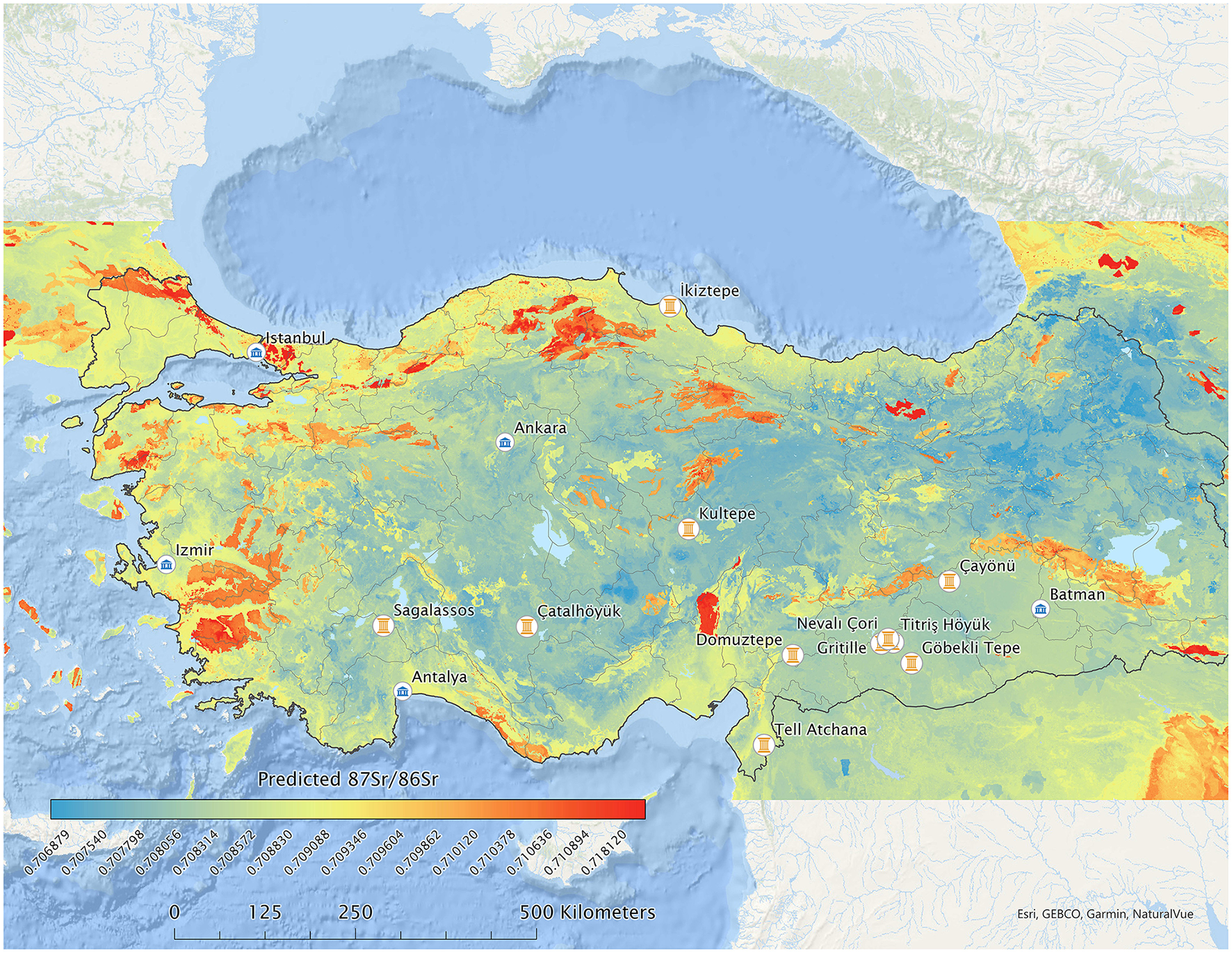
87Sr/86Sr isoscape of Türkiye created by integrating 688 empirical data points from baseline samples into the predictive global model utilizing the open-source R-script provided by Bataille et al. (2020).
5.4 Calculation of the predicted standard error
To assess the accuracy of the model within Türkiye, we also computed the predicted standard error across the landscape. This entailed using additional code in order to create a second raster to represent the standard error for each cell of predicted 87Sr/86Sr. The code paralleled the original random forest regression, but it was adapted to predict standard error instead of 87Sr/86Sr using the same predictors to best match each cell. On the map presented in Figure 5, colors proceed from cooler to warmer as the standard error progresses from smaller to larger. As we would expect, standard error is relatively smaller in areas represented by a higher number of analyzed reference samples, for example, around Hierapolis, where the systematic isoscape study by Wong et al. (2021) was conducted.
Figure 5

Map of Türkiye showing the predicted standard error in the 87Sr/86Sr isoscape model across the Anatolian landscape.
6 Geological 87Sr/86Sr variability in Türkiye and observations on the resultant map
The peninsular landmass of Anatolia (Figure 6) was formed with the closing of the Tethys Ocean during the late Cretaceous, and it is geologically divided into three tectonic units: the Pontides, the Anatolides-Taurides and the Arabian Platform (Okay, 2008): The Pontides, an amalgamation of three terrains that show markedly different geological evolutions, were faulted during the Alpide orogeny but were not metamorphized. To the contrary, Anatolide-Tauride terrain was intensely deformed and partly metamorphosed during the Alpide orogeny, leading to its subdivision into several zones based on the type and age of metamorphism. Southeastern Anatolia constitutes the northern extension of the Arabian Platform, and it shows a similar stratigraphy to the Taurus range, consisting of a clastic-carbonate dominated Palaeozoic and a carbonate dominated Mesozoic succession. Geological 87Sr/86Sr variability is well-documented especially in volcanic regions of Anatolia (Robertson and Dixon, 1996; Köksal and Göncüoğlu, 2008).
Figure 6

Simplified geological map of Türkiye (Tanoğlu, 1961).
In comparing our modeled bioavailable Sr isoscape map for Türkiye (Figure 4) with the Sr isoscape of Türkiye clipped from Bataille's global model (Figure 2), we do see a finer resolution variability at the local level in areas where there are robust datasets of analyzed samples like southwestern Anatolia and the Konya Plain. Notably, bedrock type still manifests as the dominant factor in predicting expected values. When using a modeled Sr isoscape to address questions of mobility in the archaeological record, it will be essential to approach the question as a matter of scale. Higher-resolution isoscapes generated at local and regional levels will be more useful for addressing site-level questions, whereas country- and continental-scale models should be reserved for large scale, broad interpretations.
At sub-regional scales, we found that the addition of the new dataset increased the predictive strength of the model when compared to empirical 87Sr/86Sr values from archaeological sites, with accuracy in some areas up to the fifth decimal point (e.g., for Çatalhöyük, Göbekli Tepe, Kültepe), or at least better predictive performance than Bataille et al.'s global model in other areas (e.g., for Hierapolis and southwest Anatolia, Tell Atchana and the Amuq, and Domuztepe vicinity). However, our model performed less accurately than Bataille et al.' model at two sites (İkiztepe and Köşk Höyük), demonstrating the need for higher-resolution sampling and modeling when addressing site-level questions. In the case of İkiztepe, this can be explained by the lack of biological baseline data from the vicinity of the site. Köşk Höyük is centered within ample comparative data points, and therefore, this result could be attributed to local bedrock variability in this volcanic region with a complex geology. This could also be due to the resolution of the input geological map of Türkiye, in which some of the smaller geological units, despite their differences, are aggregated into fewer categories.
7 Human mobility in ancient Anatolia
In the archaeological and historical record of southwest Asia, there are several significant episodes of broad-scale human mobility across the Anatolian peninsula, which have become specialized topics of investigation in and of themselves. Most notably, the westward spread of early farming populations in the Neolithic from Anatolia to Europe (“Neolithization”, see review in Düring, 2011) and the spread of proto-Indo-European-speaking populations in protohistory (sometime before mid-3rd millennium BCE), who later formed the Hittite kingdom and the Luwian confederacy in Anatolia, have spurred much debate in scholarship over the decades and will remain significant research topics. Additionally, Early Iron Age (ca. 1200–900 BCE) that is marked by the supra-regional collapse of centralized, territorial states and lack of textual evidence (i.e., “Dark Ages”) is characterized by the movement of new populations into Anatolia by land and by sea from the west and the east. The textual record of the following period shows that Indo-European-speaking tribes (e.g., Mushki/Phrygians), Semitic-speaking populations (e.g., Aramaeans) and others (e.g., Bianili/Urartu) had moved into various subregions of Anatolia in this obscure period. Due to the scarcity of permanent settlements, lack of texts, and paucity of human skeletal material (cremation being common practice in the Iron Age), the details about the direction, exact timing, and the process of human mobility in this period remain poorly understood (see review in Sagona and Zimansky, 2009). In the following centuries, Anatolia and surrounding regions went through the cycles of political consolidation and disintegration with the formation of territorial kingdoms in the Middle Iron Age, the expansion and confrontation of the Lydian and the Persian empires, the emergence and fragmentation of Alexander's empire, followed by the rise and fall of the Roman, Byzantine, Seljuk, and Ottoman empires. Human skeletal assemblages from these later periods are typically underrepresented due to preservation issues and a delayed interest in the human skeletal record of more recent periods in contrast to prehistoric/protohistoric sites in Anatolian archaeology (Üstündağ and Yazıcıoğlu, 2014).
Bioarchaeological remains from early prehistoric sites of Anatolia, as discussed above, have received much greater attention from an analytical perspective, as opposed to later periods. Multi-isotopic investigations at the pre-pottery and early Neolithic sites of southeastern and south-central Anatolia constitute a large portion of isotopic analyses carried out to date in Anatolia, followed by Bronze Age sites (Irvine and Özdemir, 2020). To increase our insight into the experienced human mobilities in more recent state societies and their cycles of territorial expansion and disintegration, 87Sr/86Sr ratio analysis would be an apt strategy especially at sites where the historical transitions are documented by stratified sequences and in multi-period cemeteries. There are other cases of local and regional mobilities in and into Anatolia, which have not been investigated isotopically. Among these, the southward expansion of the Early Transcaucasian cultural sphere in eastern/southeastern Anatolia across the EBA, the impact of EBA urbanization along the upper Euphrates, the influx and dispersal of populations in western and eastern Anatolia in the EIA, forced deportations by the Urartian kingdom and the Neo-Assyrian empire in the MIA, the arrival and expansion of the Galatians in west-central Anatolia in the Hellenistic period, and Greek colonies on Anatolian shores are specific cases of human mobility that are evidenced in the archaeological and textual record and merit deeper investigations utilizing multi-isotopic analyses, including strontium. Currently, an emerging focus of interest in bioarchaeology of Anatolia is the Middle Ages, during which the Crusades, Early Christian pilgrimage sites, and the shifting frontiers between the East Roman (Byzantine) empire and the Mongol invasions and later Turkic principalities present intriguing cases of human mobility that can be investigated by text-aided archaeology and well-contextualized interpretations of multi-isotopic analyses of human remains.
Seasonal human mobility in tandem with nomadic and transhumant pastoralism, which has until recently been a strong component of rural subsistence economy in Anatolia, is another important research topic that can be tackled with strontium (and oxygen) isotope ratio analysis of animal and human remains. Although herding and grazing strategies have been investigated at several Anatolia sites, considering the pastoralist basis of many tribal states in Anatolia beginning with the Iron Age, further systematic investigations of seasonal mobility patterns, aided by ethnographic research, would greatly benefit our understanding of not only subsistence economy and human mobility in the past but also political organization in significant periods of social transformation. An interesting question that has not yet been investigated by isotopic analysis in Anatolian archaeology is the mobility of animals by trade, exchange, and conquest/conflict. In this regard, horses taken as tribute from neighboring lands by the Urartian army in eastern Anatolia, donkeys brought to central Anatolia from Iraq by the (Old) Assyrian trade caravans and traded in Anatolia, and horses trained for the armies of the Hittite Empire in south-central Anatolia are distinct cases of long-distance animal mobility that can be empirically documented by 87Sr/86Sr analysis. Wood/timber provisioning/trade is also a promising subject to explore at Anatolian sites with good wood preservation (e.g., Gordion and its tumuli) and in underwater archaeology.
Importantly, ancient human mobility studies have been increasingly adapting interdisciplinary research strategies, utilizing strontium isotope ratio analysis in conjunction with anthropological biodistance studies and aDNA analysis (e.g., Çatalhöyük, Nevali Çori, Tell Atchana; Başur Höyük, Alişar, Table 1). This research strategy is particularly powerful in providing at once an isotopic, high-resolution perspective into short-term human mobility (human lifetime and within one or two generations) and a genetic, long-term perspective on the movement of populations through the generations across broader landscapes. The pairing of isotopic and genetic datasets from the same population bears a higher potential to reveal the nature of case-specific mobilities than either of the methods employed alone (Haak et al., 2008).
8 Discussion
The basic premise of this study is that the analytical power, utility, and accuracy of strontium isotope ratio analysis increase manifold when 87Sr/86Sr of archaeological samples can be referenced to a robust baseline of the geographical distribution of bioavailable Sr isotope ratios. This is valid for various scales of analysis including big questions like the spread of early humans, the “Neolithic package”, or proto-Indo-European languages as well as regional-to-local scale questions regarding hunting, herding strategies, exogamy, and kinship-based mobilities. Whether we are studying human mobility, the migration of animal species, or socioeconomic trade in animal and plant commodities, a robust bioavailable 87Sr/86Sr isoscape is imperative for realizing the full potential of this biogeochemical method and accurate interpretation of 87Sr/86Sr data from bioarchaeological remains. Isoscapes covering broad geographical areas allow enhanced assessment of the nature of variability in isotopic values from bioarchaeological remains. Predictively modeled isoscapes utilize machine learning algorithms to account for multiple variables that influence the geographical variation in bioavailable strontium isotopes and allow us to visualize isotopic variation as a continuous surface across the landscape (Meiggs et al., 2018). This mapping tool is particularly helpful in showing the spatial distribution of isotopic values in areas where variation in regional geology has units that mix different source areas (e.g., fluvial areas) or units whose composition produce strontium isotope values that overlap with the site-centered baseline. Bioavailable strontium isoscapes are more refined in areas that have an intensive coverage of empirical data procured from systematically collected baseline samples representing distinct geological units (e.g., Wong et al., 2021). Small-scale variation in geology, as is present in many areas of Anatolia, may cause potential over interpretation of “non-local” vs. “local” individuals, if “local range” has been defined by geographically narrow environmental samples. This becomes especially important where the geology immediately surrounding a site may be different than the agricultural and pastoral land utilized for the dietary input of that site's population. Therefore, it is important to design sampling strategies for baseline determination that best fit the research question pursued, and it is necessary to base archaeological interpretations not solely on the numerical correspondence between 87Sr/86Sr values from bioarchaeological samples and geographical areas but on a contextualized evaluation of isotopic data together with multiple lines of bioarchaeological and associated material culture evidence (cf. Nafplioti, 2021). Furthermore, broadscale isoscapes facilitate answering specific research questions that explicitly hypothesize large-scale mobility, such as the Early Iron Age/Archaic Period migrations in the Aegean. Current bioavailable data from western Anatolia show some similar values to those in the greater Aegean, creating a need for broader consideration of mobility in regard to overlapping 87Sr/86Sr ratios in different regions (cf. discussion in Nafplioti, 2021). Recent initiatives in generating broadscale, open access 87Sr/86Sr databases for the Mediterranean basin (e.g., SrIsoMed, Nikita et al., 2022) corroborate the fact that this need is recognized by the scholarly community, and yet 87Sr/86Sr isoscapes of Anatolia remains a terra incognita at large.
In site-scale mobility studies worldwide, researchers have previously defined the “local range” by the statistical majority of analyzed bioarchaeological samples (within 2 s.d.); they have extrapolated expected 87Sr/86Sr values for the local environment based on bedrock geology; or they have analyzed a relatively small number of samples (archaeological and modern small fauna, snail shells, plants) to serve as geographical reference for local baseline determination. All three of these approaches have been used in archaeological research across Anatolia, making it a challenging task to gain a cohesive picture of the extent of bioavailable 87Sr/86Sr variability in relation to bedrock values. Ultimately, these approaches address different scales of variation, and the extent to which each provides the ability to interpret mobility more accurately depends on the particular circumstances of the site and research question. For example, high variability in local bedrock 87Sr/86Sr values may result in highly variable 87Sr/86Sr values within sampled individuals. This variability may be misinterpreted as a non-local or highly mobile signature despite this not being the case. This issue is not unique to Anatolia and remains a limiting factor more broadly in geologically complex regions. The reverse is also true: lack of variability in 87Sr/86Sr values across wide geographical units (e.g., the limestone lithology of the circum-Mediterranean), which would result in a restricted range of 87Sr/86Sr values from bioarchaeological samples, may be masking distinct geographical origins and mobility patterns of the sampled individuals. At the scale of meta-analysis, the cumulative evaluation of the high percentages of individuals identified as “locals” in separate studies may lead to broad claims about the lack of mobility in the ancient world, albeit debatable (e.g., Leppard et al., 2020 vs. Perry et al., 2022). In fact, the presence of broad regions with overlapping 87Sr/86Sr values in the Mediterranean isoscape suggests that the high percentages of “local” individuals in the archaeological record is a manifestation of the methodological limitations of Sr isotopic analysis in detecting mobile individuals, rather than being indicative of a broad historical pattern. This methodological shortcoming of Sr isotopic analysis can be overcome by conducting multi-isotopic analyses for assessing mobility (oxygen, sulfur) and dietary (carbon, nitrogen) patterns, creating isoscapes for other isotopes (Nafplioti, 2021), and using the entire gamut of bioarchaeological methods in assessing biodistance (Gregoricka, 2021).
The application of 87Sr/86Sr analysis to archaeological studies of mobility remains limited in part by the cost of obtaining bioavailable87Sr/86Sr values from large numbers of samples needed for establishing a local “baseline” empirically, which in turn restricts our ability to derive interpretations from the isotopic analysis of bioarchaeological remains. Further, depending on the types of environmental samples used in a given study, different scales of strontium variation may be represented, and integrating these data into a coherent picture presents a challenge in ascertaining broadscale variation. The lack of adequate baseline data also remains problematic in many regions, especially those which remain less accessible to researchers due to remoteness or political unrest. Advances in the field in recent years led to the development of alternative methodologies that combine available empirical data with multi-variate statistics and machine learning algorithms to create isoscapes (isotopic landscapes), which allow us to visualize a spatially continuous distribution of predicted 87Sr/86Sr values across the landscape rather than a spotty distribution of empirical 87Sr/86Sr values, providing a broader coverage at a much lower cost. A recent advance in this direction is the global model of 87Sr/86Sr isoscapes, created by Bataille et al. (2020), which incorporates geological 87Sr/86Sr data from Türkiye but does not include any empirical 87Sr/86Sr data from archaeological studies at ancient Anatolian sites (Figure 2).
9 Conclusions
In this study, we demonstrated that, as expected, the accuracy of this global model for Türkiye increases with the incorporation of empirical 87Sr/86Sr data from archaeological studies. To this end, we combined our unpublished 87Sr/86Sr data from baseline samples with all available 87Sr/86Sr data from published research and unpublished dissertations on Anatolian sites (Tables 1, 2; Supplementary materials 1, 2). After compiling the data from all sample types, we systematically eliminated data from human and domesticated animal species, and we reduced this dataset to only include 87Sr/86Sr data from in situ, georeferenced samples (archaeological and modern flora, wild fauna, mollusk/snail shell, and soil) that can serve as empirical baseline data. Following the analytical steps described in this study, we incorporated the resultant 688 datapoints into Bataille et al.'s global database of 87Sr/86Sr values and re-generated the Türkiye portion of the 87Sr/86Sr isoscape map (Figure 4), as well as a map of standard error distribution (Figure 5), using the R-script provided by Bataille et al. (2020). The resulting ground-truthed isoscape introduced more nuanced 87Sr/86Sr variability to the modeled map, increased its accuracy, and led to three major observations. First and foremost, as Figure 1 clearly demonstrates, the geographical distribution of 87Sr/86Sr datasets in Anatolia is very uneven, with sampled sites clustering in the southern half of the peninsula and no analyses in vast areas of the northern and eastern portions of the country. Second, because of this uneven distribution, when statistically tested against analytical results from archaeological samples, the predictive isoscape model performs with higher accuracy in regions represented by larger empirical datasets, as opposed to northern sites not covered by extensive baseline sampling (e.g., İkizepe). And third, the relatively poor performance of the model in Cappadocia despite the presence of ample baseline data at and around prehistoric Köşk Höyük suggests that, in regions with a particularly complex geology (e.g., volcanism) where the resolution of geology maps may not be optimal, more intensive coverage by site-scale, empirical baseline studies is necessary.
In the future stages of this project, we hope to expand the spatial boundaries of our research objective to include neighboring regions of the “Greater Ancient Near East” (Balkans and the Aegean, the Caucasus, Iran, and Syro-Mesopotamia), where we have already completed data-harvesting within the framework of the BioIsoANE Project (Irvine and Yazıcıoğlu Santamaria, 2021). It is worth noting that global and pan-regional isoscapes are useful and relevant for archaeological research (and environmental sciences, geology, and forensics), but generating high-resolution isoscapes at local and regional levels will likely be the most effective strategy for addressing the relevant spatiotemporal scales of research questions related to ancient human and animal mobility. It is our hope that a higher resolution ground-truthed bioavailable 87Sr/86Sr isoscape map for all Türkiye will allow for the eventual use of statistical packages to model what is known as “individual assignment” for people and animals, used for probabilistically pinpointing the most likely geographical origin(s) of mobile individuals (cf. Bowen et al., 2014). Generating additional local datasets and more robust models will also allow us to reassess the power or perhaps the limitations of Sr isotope analysis in provenancing bioarchaeological individuals in our research region. This may in turn lay the groundwork for advocating the pairing of Sr isotope analysis with isotopic analyses of oxygen, sulfur, and/or lead for finer-resolution interpretations of ancient mobility.
Statements
Data availability statement
The original contributions presented in the study are included in the article/Supplementary material, further inquiries can be directed to the corresponding author.
Author contributions
GBY: Conceptualization, Data curation, Investigation, Methodology, Project administration, Validation, Writing – original draft, Writing – review & editing. DCM: Conceptualization, Formal analysis, Investigation, Methodology, Writing – review & editing. MD: Investigation, Methodology, Software, Validation, Visualization, Writing – review & editing. SPB: Conceptualization, Funding acquisition, Investigation, Methodology, Software, Supervision, Writing – original draft, Writing – review & editing.
Funding
The author(s) declare that financial support was received for the research and/or publication of this article. The Center for Undergraduate Research Opportunities at University of Georgia, Athens, GA, USA provided financial support for the undergraduate research assistants of SPB: Claire Brandes, Hailey Reed, and Maxwell Davis in their work on data analysis and map creation. Financial support for open access publication fees has been provided by SFU Library's Central Open Access Fund, Simon Fraser University, Burnaby, BC, Canada, and Department of Anthropology, University of Georgia, Athens, GA, USA.
Acknowledgments
We thank the reviewers for their comments on the original manuscript. For data gathering, GBY has accessed BioIsoANE Database and acknowledges Benjamin Irvine (BIAA—British Institute at Ankara Honorary Fellow and BioIsoANE Project Co-PI) for his contribution to data gathering from published sources since 2020. GBY also acknowledges Dominique Langis-Barsetti for her work in creating the map in Figure 1, and Damon Tarrant, Simon Fraser University, Department of Archaeology for his feedback on this study. DCM acknowledges the Laboratory for Archeological Chemistry (LARCH), University of Wisconsin, Madison, WI, USA for facilitating analysis, and the American Research Institute in Turkey for funding and assistance for sample collection. SPB acknowledges University of Georgia, Department of Anthropology students Claire Brandes and Hailey Reed for their work using R-script and creating drafts of map visuals; Elizabeth Ridder at California State University San Marcos, CA, USA for her support and discussion of GIS software and mapping; Sarah Barakat at University of Aberdeen and Queen's University Belfast for discussion of adapting the global random forest R-script, and Clement Bataille and Gabe Bowen for discussion of the global model, data gaps, and standard error. This research article uses unpublished 87Sr/86Sr baseline data from PhD dissertations and contextual information drawn from conference paper abstracts (see Supplementary material 1). Authors respectfully acknowledge that all bioarchaeological materials subjected to isotopic analyses in laboratories outside of Türkiye, evaluated in this study, were exported from the Republic of Türkiye by the acknowledged researchers prior to the Ministry of Culture's approval of the directive in 2016 that prevents the export of bioarchaeological materials for analysis. This Regulation [Yönerge] for the Rules and Principles for Conducting Survey, Sondage, and Excavations on Cultural and Natural Heritage and its sections pertaining to the export of bioarchaeological remains [No. 94949537-10.04-32178; Chapter 2, Article 9 (1), subsections aa. and bb.] entered into force with the approval of the Ministry of Culture's office of the General Directorate of Cultural Assets and Museums on 17.02.2016.
Conflict of interest
The authors declare that the research was conducted in the absence of any commercial or financial relationships that could be construed as a potential conflict of interest.
Generative AI statement
The author(s) declare that no Gen AI was used in the creation of this manuscript.
Publisher’s note
All claims expressed in this article are solely those of the authors and do not necessarily represent those of their affiliated organizations, or those of the publisher, the editors and the reviewers. Any product that may be evaluated in this article, or claim that may be made by its manufacturer, is not guaranteed or endorsed by the publisher.
Supplementary material
The Supplementary Material for this article can be found online at: https://www.frontiersin.org/articles/10.3389/fearc.2025.1520345/full#supplementary-material
Abbreviations
PPNA, Pre-Pottery Neolithic A (10000–8800 BCE); PPNB, Pre-Pottery Neolithic B (8800–6500 BCE); EBA, Early Bronze Age (3rd millennium BCE); MBA, Middle Bronze Age (early 2nd millennium BCE); LBA, Late Bronze Age (late 2nd millennium BCE); EIA, Early Iron Age (ca. 1200–900 BCE); MIA, Middle Iron Age (9th−6th centuries BCE).
Footnotes
1.^ Geological maps of Türkiye prepared by the MTA (General Directorate of Mineral Research and Exploration) are available online at https://www.mta.gov.tr/en/maps/geological-500000.
References
1
AlQahtani S. J. Hector M. P. Liversidge H. M. (2010). Brief communication: the London atlas of human tooth development and eruption. Am. J. Phys. Anthropol.142, 481–490. 10.1002/ajpa.21258
2
Andreasen R. Thomsen E. (2021). Strontium is released rapidly from agricultural lime—Implications for provenance and migration studies. Front. Ecol. E8:588422. 10.3389/fevo.2020.588422
3
Arnold E. R. Hartman G. Greenfield H. J. Shai I. Babcock L. Maeir A. M. et al . (2016). Isotopic evidence for early trade in animals between Old Kingdom Egypt and Canaan. PLoS ONE11:e0157650. 10.1371/journal.pone.0157650
4
Balasse M. Ambrose S. H. Smith A. B. Price T. D. (2002). The seasonal mobility model for prehistoric herders in the South-western Cape of South Africa assessed by isotopic analysis of sheep tooth enamel. J. Arch. Sci.29, 917–932. 10.1006/jasc.2001.0787
5
Barberena R. Cardillo M. Lucero G. le Roux P. Tessone A. Llano C. et al . (2021). Bioavailable strontium, human paleogeography, and migrations in the southern Andes: a machine learning and GIS approach. Front. Ecol. E9:584325. 10.3389/fevo.2021.584325
6
Bataille C. P. Bowen G. J. (2012). Mapping 87Sr/86Sr variations in bedrock and water for large scale provenance studies. Chem. Geol. 304/305, 39–52. 10.1016/j.chemgeo.2012.01.028
7
Bataille C. P. Crowley B. E. Wooller M. J. Bowen G. J. (2020). Advances in global bioavailable strontium isosocapes. Palaeogeogr. Palaeoclimatol. Palaeoecol.555:10949. 10.1016/j.palaeo.2020.109849
8
Bataille C. P. von Holstein I. C. C. Laffoon J. E. Willmes M. Liu X. M. Davies G. R. et al . (2018). A bioavailable strontium isoscape for Western Europe: a machine learning approach. PLoS ONE13:e0197386. 10.1371/journal.pone.0197386
9
Bentley R. A. (2006). Strontium isotopes from the earth to the archaeological skeleton: a review. J. Archaeol. Meth. Theor.13, 135–187. 10.1007/s10816-006-9009-x
10
Bentley R. A. Knipper C. (2005). Geographical patterns in biologically available strontium, carbon, and oxygen isotope signatures in prehistoric SW Germany. Archaeometry47, 629–644. 10.1111/j.1475-4754.2005.00223.x
11
Benz M. Erdal Y. S. Sahin F. Özkaya V. Alt K. W. (2016a). “The equality of inequality: social differentiation among the hunter-fisher-gatherer community of Körtik Tepe, southeastern Turkey,” in Rich and Poor: Competing for Resources in Prehistoric Societies, eds. H. Meller, H. P. Hahn, R. Jung, and R. Risch (Halle: Landesmuseums für Vorgeschichte), 147–164.
12
Benz M. Fecher M. Scheeres M. Alt K. W. Erdal Y. S. Şahin F. S. et al . (2016b). Results of stable isotopes from Körtik Tepe, southeastern Turkey. Arkeometri Sonuçları Toplantısı31, 231–252. https://kvmgm.ktb.gov.tr/TR-44762/arkeometri-sonuclari-toplantilari.html
13
Bogaard A. Henton E. Evans J. A. Twiss K. C. Charles M. P. Vaiglova P. et al . (2014). Locating land use at Neolithic Çatalhöyük, Turkey: the implications of 87Sr/86Sr signatures in plants and sheep tooth sequences. Archaeometry56, 860–877. 10.1111/arcm.12049
14
Böhlke J. K. Horan M. (2000). Strontium isotope geochemistry of groundwaters and streams affected by agriculture, Locust Grove, MD. Appl. Geochem.15, 599–609. 10.1016/S0883-2927(99)00075-X
15
Bowen G. J. (2010). Isoscapes: spatial pattern in isotopic biogeochemistry. Ann. Rev. Earth Planet. Sci.38, 161–187. 10.1146/annurev-earth-040809-152429
16
Bowen G. J. Liu Z. Vander Zanden H. B. Zhao L. Takahashi G. (2014). Geographic assignment with stable isotopes in IsoMAP. Meth. Ecol. Evol.5, 201–206. 10.1111/2041-210X.12147
17
Bowen G. J. West J. B. (2008). Isotope landscapes for terrestrial migration research. Terr. Ecol. 2, 79–105. 10.1016/S1936-7961(07)00004-8
18
Britton K. Crowley B. E. Bataille C. P. Miller J. H. Wooller M. J. (2022). Editorial: a golden age for strontium isotope research? Current advances in paleoecological and archaeological research. Front. Ecol. E9:820295. 10.3389/fevo.2021.820295
19
Britton K. Le Corre M. Willmes M. Moffat I. Grün R. Mannino M. A. et al . (2020). Sampling plants and malacofauna in 87Sr/86Sr bioavailability studies: implications for isoscape mapping and reconstructing of past mobility patterns. Front. Ecol. E8:579473. 10.3389/fevo.2020.579473
20
Budd P. Montgomery J. Barreiro B. Thomas R. G. (2000). Differential diagenesis of strontium in archaeological human dental tissues. Appl. Geochem.15, 687–694. 10.1016/S0883-2927(99)00069-4
21
Capo R. C. Stewart B. W. Chadwick O. A. (1998). Strontium isotopes as tracers of ecosystem processes: theory and methods. Geoderma82, 197–225. 10.1016/S0016-7061(97)00102-X
22
Chazin H. Gordon G. W. Knudson K. J. (2019). Isotopic perspectives on pastoralist mobility in the Late Bronze Age South Caucasus. J. Anthropol. Archaeol.54, 48–67. 10.1016/j.jaa.2019.02.003
23
Degryse P. Schneider J. Haack U. Lauwers V. Poblome J. Waelkens M. et al . (2006). Evidence for glass ‘recycling' using Pb and Sr isotopic ratios and Sr-mixing lines: the case of early Byzantine Sagalassos. J. Archaeol. Sci.33, 494–501. 10.1016/j.jas.2005.09.003
24
Dufour E. Holmden C. Van Neer W. Zazzo A. Patterson W. P. Degryse P. et al . (2007). Oxygen and strontium isotopes as provenance indicators of fish at archaeological sites: the case study of Sagalassos, SW Turkey. J. Archaeol. Sci.34, 1226–1239. 10.1016/j.jas.2006.10.014
25
Düring B. S. (2011). The Prehistory of Asia Minor: From Complex Hunter-Gatherers to Early Urban Societies. Cambridge: Cambridge University Press.
26
Evans J. A. Montgomery J. Wildman G. Boulton N. (2010). Spatial variations in biosphere 87Sr/86Sr in Britain. J. Geol. Soc.167, 1–4. 10.1144/0016-76492009-090
27
Farkaš J. Wallmann K. Mosley L. Staudigel P. Zheng X-. Y. Leyden E. et al . (2025). “Alkalinity and elemental cycles in present and past ocean: insight from geochemical modeling and alkali and alkaline earth metal isotopes,” in Treatise on Geochemistry, Third edition, Vol. 5, eds. A. Anbar, and D. Weis (Rotterdam: Elsevier), 33–87.
28
Faure G. (1986). Principles of Isotope Geology, Second Edition (New York: John Wiley and Sons).
29
Flockhart D. T. T. Kyser T. K. Chipley D. Miller N. G. Norris D. R. (2015). Experimental evidence shows no fractionation of strontium isotopes (87Sr/86Sr) among soil, plants, and herbivores: implications for tracking wildlife and forensic science. Isotopes Environ. Health St.51, 372–381. 10.1080/10256016.2015.1021345
30
Frank A. B. Frei R. Moutafi I. Voutsaki S. Orgeolet R. Kristiansen K. et al . (2021b). The geographic distribution of bioavailable strontium isotopes in Greece—A base for provenance studies in archaeology. Sci. Total Environ.791:148156. 10.1016/j.scitotenv.2021.148156
31
Frank A. B. Frei R. Triantaphyllou M. Vassiliakis E. Kristiansen K. Frei K. M. et al . (2021a). Isotopic range of bioavailable strontium on the Peloponnese peninsula, Greece: a multi-proxy approach. Sci. Total Environ. 774:145181. 10.1016/j.scitotenv.2021.145181
32
Giblin J. I. Knudson K. J. Bereczki Z. Pálfi G. Pap I. (2013). Strontium isotope analysis and human mobility during the Neolithic and Copper Age: a case study from the Great Hungarian Plain. J. Archaeol. Sci.40, 227–239. 10.1016/j.jas.2012.08.024
33
Gigante M. Mazzariol A. Bonetto J. Armaroli E. Cipriani A. Lugli F. et al . (2023). Machine learning-based Sr isoscape of southern Sardinia: a tool for bio-geographic studies at the Phoenician-Punic site of Nora. PLoS ONE18:e0287787. 10.1371/journal.pone.0287787
34
Goldstein S. Hixon S. Scott E. Wolfhagen J. Iminjili V. Janzen A. et al . (2022). Presenting the AfriArch isotopic database. J. Open Archaeol. Data10, 1–9. 10.5334/joad.94
35
Gregoricka L. A. (2021). Moving forward: a bioarchaeology of mobility and migration. J. Archeol. Res.29, 581–635. 10.1007/s10814-020-09155-9
36
Haak W. Brandt G. de Jong H. N. Meyer C. Gansimeier R. Heyd V. et al . (2008). Ancient DNA, strontium isotopes, and osteological analyses shed light on social and kinship organization of the Later Stone Age. Proc. Natl. Acad. Sci. USA105, 18226–18231. 10.1073/pnas.0807592105
37
Hammer E. L. Arbuckle B. (2017). 10,000 years of pastoralism in Anatolia: a review of evidence for variability in pastoral lifeways. Nomadic Peoples20, 214–267. 10.3197/np.2017.210204
38
Hartman G. Richards M. (2014). Mapping and defining sources of variability in bioavailable strontium isotope ratios in the Eastern Mediterranean. Geochim. Cosmochim. Acta126, 250–264. 10.1016/j.gca.2013.11.015
39
Haverkort C. M. Weber A. Katzenberg M. A. Goriunova O. I. Simonetti A. Creaser R. A. et al . (2008). Hunter-gatherer mobility strategies and resource use based on strontium isotope (87Sr/86Sr) analysis: a case study from Middle Holocene Lake Baikal, Siberia. J. Archaeol. Sci.35, 1265–1280. 10.1016/j.jas.2007.09.002
40
Hillson S. (1996). Dental Anthropology. Cambridge: Cambridge University Press.
41
Holt E. Evans J. A. Madgwick R. (2021). Strontium (87Sr/86Sr) mapping: a critical review of methods and approaches. Earth-Sci. Rev.216:103593. 10.1016/j.earscirev.2021.103593
42
Ingman T. (2020). Identity and changing funerary rituals at Tell Atchana, Alalakh: Mortuary and isotopic analyses (PhD dissertation). Istanbul: Koç University.
43
Ingman T. Eisenmann S. Skourtanioti E. Akar M. Ilgner J. Gnecchi Ruscone G. A. et al . (2021). Human mobility at Tell Atchana (Alalakh) during the 2nd millennium BC: integration of isotopic and genomic evidence. PLoS ONE16:e0241883. 10.1371/journal.pone.0241883
44
Irvine B. Özdemir K. (2020). Biogeochemical approaches to bioarchaeological research in Turkey: a review. J. Eas. Med. Arch. Her. Stu.8, 174–99. 10.5325/jeasmedarcherstu.8.2.0174
45
Irvine B. Yazıcıoğlu Santamaria G. B. (2021). BioIsoANE: an open-access repository of bioarchaeological isotopic analyses in the Greater Ancient Near East. BIAA Heritage Türkiye11, 26–27. 10.18866/biaa2021.12
46
Janzen A. Bataille C. Copeland S. R. Quinn R. L. Ambrose S. H. Reed D. et al . (2020). Spatial variation in bioavailable strontium isotope ratios (87Sr/86Sr) in Kenya and northern Tanzania: implications for ecology, paleoanthropology, and archaeology. Palaeogeogr. Palaeoclimatol. Palaeoecol.560:109957. 10.1016/j.palaeo.2020.109957
47
Knudson K. J. Williams H. M. Buikstra J. E. Tomczak P. D. Gordon G. W. Anbar A. D. et al . (2010). Introducing 88Sr/86Sr analysis in archaeology: a demonstration of the utility of strontium isotope fractionation in paleodietary studies. J. Archaeol. Sci.37, 2352–2364. 10.1016/j.jas.2010.04.009
48
Köksal S. Göncüoğlu M. C. (2008). Sr and Nd isotopic characteristics of some S-, I-, and A-type granitoids from central Anatolia. Turkish J. Earth Sci.17, 111–127. https://journals.tubitak.gov.tr/earth/vol17/iss1/5
49
Köksal S. Romer R. L. Göncüoğlu M. C. Toksoy-Köksal F. (2004). Timing of post-collisional H-type to A-type granitic magmatism: U-Pb titanite ages from the Alpine central Anatolian granitoids (Turkey). Int. J. Earth Sci.93, 974–989. 10.1007/s00531-004-0432-5
50
Lang C. Peters J. Pöllath N. Schmidt K. Grupe G. (2013). Gazelle behaviour and human presence at early Neolithic Göbekli Tepe, south-east Anatolia. World Archaeol.45, 410–429. 10.1080/00438243.2013.820648
51
Larsen C. S. Knüsel C. J. Haddow S. D. Pilloud M. A. Milella M. Sadvari J. W. et al . (2019). Bioarchaeology of Neolithic Çatalhöyük reveals fundamental transitions in health, mobility, and lifestyle in early farmers. Proc. Natl. Acad. Sci.116, 12615–12623. 10.1073/pnas.1904345116
52
Lau H. Gordon G. W. Knudson K. J. (2021). Reconstructing feast provisioning at Halaf Domuztepe: Evidence from radiogenic strontium analyses. J. Archaeol. Sci.131, 105408. 10.1016/j.jas.2021.105408
53
Lau H. K.-Y. (2016). Mobility, cooperation, and emergent social complexity in the Late Neolithic Near East (PhD dissertation). Los Angeles, CA: University of California Los Angeles.
54
Lengfelder F. Grupe G. Stallauer A. Huth R. Söllner F. (2019). Modelling strontium isotopes in past biospheres - Assessment of bioavailable 87Sr/86Sr ratios in local archaeological vertebrates based on environmental signatures. Sci. Total Environ. 648, 236–252. 10.1016/j.scitotenv.2018.08.014
55
Leppard T. P. Esposito C. Esposito M. (2020). The bioarchaeology of migration in the ancient Mediterranean: meta-analysis of radiogenic (87Sr/86Sr) isotope ratios. J. Mediterr. Archaeol.33, 211–241. 10.1558/jma.18784
56
Lewis J. Pike A. W. G. Coath C. D. Evershed R. P. (2017). Strontium concentration, radiogenic 87Sr/86Sr and stable (δ88Sr) strontium isotope systematics in a controlled feeding study. Sci. Technol. Archaeol. Res.3, 45–57. 10.1080/20548923.2017.1303124
57
Lugli F. Cipriani A. Bruno L. Ronchetti F. Cavazzuti C. Benazzi S. et al . (2022). A strontium isoscape of Italy for provenance studies. Chem. Geol.587, 120624. 10.1016/j.chemgeo.2021.120624
58
Mantile N. Fernandes R. Lubritto C. Cocozza C. (2023). IsoMedIta: a stable isotope database for medieval Italy. Res. Data J. Humanit. Soc. Sci.8, 1–13. 10.1163/24523666-bja10032
59
Maurer A-. F. Galer S. J. G. Knipper C. Beierlein L. Nunn E. V. Peters D. et al . (2012). Bioavailable 87Sr/86Sr in different environmental samples - Effects of anthropogenic contamination and implications for isoscapes in past migration studies. Sci. Total Environ. 433, 216–229. 10.1016/j.scitotenv.2012.06.046
60
McArthur J. M. Howarth R. J. Bailey T. R. (2001). Strontium isotope stratigraphy: LOWESS version 3: Best fit to the marine Sr-isotope curve for 0-509 Ma and accompanying look-up table for deriving numerical age. J. Geol.109, 155–170. 10.1086/319243
61
Meiggs D. C. (2009). Investigation of Neolithic herding practices by multiple isotope analysis: A case study at PPNB Gritille, southeastern Turkey (PhD dissertation). Madison, WI: University of Wisconsin.
62
Meiggs D. C. (2011). Herding practices, urban provisioning, and human mobility at Tell Atchana (Alalakh): 2009 strontium isotope (87Sr/86Sr) results. Arkeometri Sonuçları Toplantısı26, 51–68. https://kvmgm.ktb.gov.tr/TR-44762/arkeometri-sonuclari-toplantilari.html
63
Meiggs D. C. Arbuckle B. S. Öztan A. (2018). “The pixelated shepard: identifying detailed land-use practices at Chalcolithic Köşk Höyük, Central Turkey, using a strontium isotope (87Sr/86Sr) isoscape,” in Isotopic Investigations of Pastoralism in Prehistory, eds. A. R. Ventresca Miller, and C. Makarewicz (London: Routledge), 77–95.
64
Montgomery J. (2010). Passports from the past: investigating human dispersals using strontium isotope analysis of tooth enamel. Ann. Human Biol.37, 325–346. 10.3109/03014461003649297
65
Montgomery J. Evans J. A. Cooper R. E. (2007). Resolving archaeological populations with Sr-isotope mixing models. Appl. Geochem.22, 1502–1514. 10.1016/j.apgeochem.2007.02.009
66
Müller W. Lugli F. McCormack J. Evans D. Anczkiewicz R. Bondioli L. et al . (2025). “Human life histories,” in Treatise on Geochemistry, Third edition, Vol. 6, eds. A. Anbar, and D. Weis (Rotterdam: Elsevier), 281–328.
67
Nafplioti A. (2011). Tracing population mobility in the Aegean using isotope geochemistry: a first map of biologically available 87Sr/86Sr signatures. J. Archaeol. Sci.38, 1560–1570. 10.1016/j.jas.2011.02.021
68
Nafplioti A. (2021). Moving forward: strontium isotope mobility research in the Aegean, Mediterr. Archaeol. Archaeom.21, 165–179. 10.5281/zenodo.5057552
69
Nebel O. Scherer E. E. Mezger K. (2011). Evaluation of the 87Rb decay constant by age comparison against the U–Pb system. Earth Planet. Sci. Lett.301, 1–8. 10.1016/j.epsl.2010.11.004
70
Nelson B. K. DeNiro M. J. Schoeninger M. J. De Paolo D. J. (1986). Effects of diagenesis on strontium, carbon, nitrogen and oxygen concentration and isotopic composition of bone. Geochim. Cosmochim. Acta50, 1941–1949. 10.1016/0016-7037(86)90250-4
71
Nikita E. Mardini M. Degryse P. (2022). SrIsoMed: an open access strontium isotopes database for the Mediterranean. J. Archaeol. Sci. Rep.45:103606. 10.1016/j.jasrep.2022.103606
72
Okay A. I. (2008). Geology of Turkey: a synopsis. Anschnitt21, 19–42.
73
Pearson J. A. Evans J. Lamb A. Baird D. Hodder I. Marciniak A. et al . (2023). Mobility and kinship in the world's first village societies. Proc. Natl. Acad. Sci.120:e2209480119. 10.1073/pnas.2209480119
74
Perry M. A. Killgrove K. Gregoricka L. A. Prowse T. L. (2022). Towards accurate meta-analyses in Mediterranean bioarchaeology: a critical response to Leppard et al. (JMA 33, 2020). J. Mediterranean Archaeol.35, 108–132. 10.1558/jma.23771
75
Pişkin E. Köksal S. Durdu G. (2023). Animal husbandry, isotopes, and land use at the Late Bronze Age Hittite city of Sapinuva (Šapinuwa), Turkey: insights from strontium isotopes. Archaeol. Anthropol. Sci.15:65. 10.1007/s12520-023-01759-8
76
Poszwa A. Ferry B. Dambrine E. Pollier B. Wickman T. Loubet M. et al . (2004). Variations of bioavailable Sr concentration and 87Sr/86Sr ratio in boreal forest ecosystems: role of biocycling, mineral weathering and depth of root uptake. Biogeochem.67, 1–20. 10.1023/B:BIOG.0000015162.12857.3e
77
Price T. D. Burton J. H. Bentley R. A. (2002). The characterization of biologically available strontium isotope ratios for the study of prehistoric migration. Archaeometry44, 117–135. 10.1111/1475-4754.00047
78
Probst A. El Gh'mari A. Aubert D. Fritz B. McNutt R. (2000). Strontium as a tracer of weathering processes in a silicate catchment polluted by acid atmospheric inputs, Strengbach, France. Chem. Geol.170, 203–219. 10.1016/S0009-2541(99)00248-X
79
Prytulak J. König S. (2025). “Stable isotope variations in arc lavas,” in Treatise on Geochemistry, Third edition, Vol. 1, eds. A. Anbar, and D. Weis (Rotterdam: Elsevier), 671–701.
80
Rich S. Manning S. W. Degryse P. Vanhaecke F. Latruwe K. van Lerberghe K. et al . (2016). To put a cedar ship in a bottle: dendroprovenancing three ancient East Mediterranean watercraft with the 87Sr/86Sr isotope ratio. J. Archaeol. Sci. Rep.9, 514–521. 10.1016/j.jasrep.2016.08.034
81
Rich S. A. Manning S. W. Degryse P. Vanhaecke F. van Lerberghe K. (2015). Provenancing East Mediterranean cedar wood with the 87Sr/86Sr strontium isotope ratio. Archaeol. Anthropol. Sci. 8, 467–476. 10.1007/s12520-015-0242-7
82
Robertson A. H. F. Dixon J. E. (1996). “Introduction: aspects of the geological evolution of the Eastern Mediterranean”, in The Geological Evolution of the Eastern Mediterranean, eds. J. E. Dixon, and A. H. F. Robertson (London: The Geological Society), 1–74.
83
Sagona A. Zimansky P. (2009). Ancient Turkey. London and New York: Routledge.
84
Salesse K. Fernandes R. de Rocheforte X. Brůžek J. Castex D. Dufour É. (2018). IsoArcH.eu: an open-access and collaborative isotope database for bioarchaeological samples from the Graeco-Roman world and its margins. J. Archaeol. Sci.19, 1050–1055. 10.1016/j.jasrep.2017.07.030
85
Snoeck C. Ryan S. Pouncett J. Pellegrini M. Claeys P. Wainwright A. N. et al . (2020). Towards a biologically available strontium isotope baseline for Ireland. Sci. Total Environ. 712:136248. 10.1016/j.scitotenv.2019.136248
86
Tanoğlu A. (1961). Türkiye Atlası/Atlas of Turkey. Istanbul: National Board of Education.
87
Tarrant D. Hepburn J. Renson V. Richards M. (2024). A pilot bioavailable strontium isotope baseline map of Southern British Columbia, Canada. Facets9, 1–11. 10.1139/facets-2023-0173
88
Toncala A. Trautmann B. Velte M. Kropf E. McGlynn G. Peters J. et al . (2020). On the premises of mixing models to define local bioavailable 87Sr/86Sr ranges in archaeological contexts. Sci. Total Environ.745:140902. 10.1016/j.scitotenv.2020.140902
89
Üstündağ H. Yazıcıoğlu G. B. (2014). “History of physical anthropology in Turkey”, in Archaeological Human Remains: Global Perspectives, eds. B. O'Donnabhain, and M. C. Lozada (London: Springer), 199–212. 10.1007/978-3-319-06370-6_15
90
Wang X. Skourtaniotib E. Benz M. Gresky J. Ilgner J. Lucas M. et al . (2023). Isotopic and DNA analyses reveal multiscale PPNB mobility and migration across southeastern Anatolia and the southern Levant. Proc. Natl. Acad. Sci.120:e2210611120. 10.1073/pnas.2210611120
91
Welton L. (2015). “Isotopic indicators of community organisation and integration at İkiztepe: implications for Anatolian social development in the 4th millennium BC,” in Western Anatolia Before Troy, eds. B. Horejs, and M. Mehofer (Vienna: Österreichische Akademie der Wissenschaften), 395–412.
92
Welton M. L. (2010). Mobility and social organization on the ancient Anatolian Black Sea coast: An archaeological, spatial, and isotopic investigation of the cemetery at Ikiztepe, Turkey (PhD dissertation). Toronto, ON: University of Toronto.
93
Wheatley D. Gillings M. (2002). Spatial Technology and Archaeology: The Archaeological Applications of GIS. London: Taylor and Francis.
94
Whipkey C. E. Capo R. C. Chadwick O. A. Stewart B. W. (2000). The importance of sea spray to the cation budget of a coastal Hawaiian soil: a strontium isotope approach. Chem. Geol.168, 37–48. 10.1016/S0009-2541(00)00187-X
95
White W. M. (2023). Isotope Geochemistry, Second Edition.New York: John Wiley and Sons.
96
Wilkinson M. D. Dumontier M. Aalbersberg I. J. Appleton G. Axton M. Baak A. et al . (2016). The FAIR Guiding Principles for scientific data management and stewardship. Sci. Data3:160018. 10.1038/sdata.2016.18
97
Willmes M. Bataille C. P. James H. F. Moffat I. McMorrow L. Kinsley L. et al . (2018). Mapping of bioavailable strontium isotope ratios in France for archaeological provenance studies. Appl. Geochem.90, 75–86. 10.1016/j.apgeochem.2017.12.025
98
Wong M. Brandt J. R. Ahrens S. Jaouen K. Bjørnstad G. Naumann E. et al . (2018). Pursuing pilgrims: Isotopic investigations of Roman and Byzantine mobility at Hierapolis, Turkey. J. Archaeol. Sci. Rep.17, 520–528. 10.1016/j.jasrep.2017.12.005
99
Wong M. Grimes V. Steskal M. Richards M. (2021). A bioavailable baseline strontium isotope map of southwestern Turkey for mobility studies. J. Archaeol. Sci. Rep.37:102922. 10.1016/j.jasrep.2021.102922
100
Wong M. Naumann E. Jaouen K. Richards M. P. (2017). “Isotopic investigations of human diet and mobility at the site of Hierapolis, Turkey,” in Life and Death in Asia Minor in Hellenistic Roman and Byzantine Times, eds J. R. Brandt, E. Hagelberg, G. Bjørnstad, and S. Ahrens (Oxford: Oxbow), 228–236.
101
Wong M. Steskal M. Grimes V. Richards M. P. (2019). “Pursuing pilgrims: Isotopic investigations of Roman and Byzantine populations at Hierapolis and Ephesos,” in Paper presented at ASOR Annual Meeting, November 20–23 (San Diego, CA). Available online at: https://www.asor.org/am/meetings/
102
Yazıcıoǧlu Santamaria G. B. (2015). The people of Kanesh: Residential mobility, community life, and cultural pluralism in a Bronze Age city in Anatolia, Turkey (PhD dissertation). Chicago, IL: University of Chicago.
103
Yazıcıoğlu Santamaria G. B. (2017). “Locals, immigrants, and marriage ties at Kültepe: results of strontium isotope analysis on human teeth from lower town graves,” in Movement, Resources, Interaction, eds. F. Kulakoğlu, and G. Barjamovic (Turnhout: Brepols), 63–84.
104
Yazıcıoğlu G. B. (2007). “Archaeological politics of Anatolia: Imaginative identity of an imaginative geography,” in Social Orders and Social Landscapes: Proceedings of the 2005 University of Chicago Conference on Eurasian Archaeology, eds. L. Popova, C. H., and A. T. Smith (Newcastle upon Tyne: Cambridge Scholars Press), 218–250.
105
Yazıcıoğlu G. B. Irvine B. (2025). “The BioIsoANE database and the development of bioarchaeological isotopic investigations in Türkiye,” in Archaeology of Anatolia, vol. 5, eds. S. Branting, J. W. Lehner, D. Langis-Barsetti, T. Kalaycı, G. B. Yazıcıoğlu, S. R. Steadman, et al. (Cambridge: Cambridge Scholars Press), p. 1–14.
Summary
Keywords
87Sr/86Sr analysis, bioavailable strontium isotopes, isoscapes, mobility, random forest regression (RFR), kriging, Anatolia, Türkiye
Citation
Yazıcıoğlu GB, Meiggs DC, Davis M and Pilaar Birch SE (2025) Emerging strontium isoscapes of Anatolia (Türkiye): new datasets and perspectives in bioavailable 87Sr/86Sr baseline studies. Front. Environ. Archaeol. 4:1520345. doi: 10.3389/fearc.2025.1520345
Received
31 October 2024
Accepted
07 April 2025
Published
18 June 2025
Volume
4 - 2025
Edited by
Argyro Nafplioti, Foundation for Research and Technology Hellas (FORTH), Greece
Reviewed by
Charlotte King, University of Otago, New Zealand
Petrus Le Roux, University of Cape Town, South Africa
Updates
Copyright
© 2025 Yazıcıoğlu, Meiggs, Davis and Pilaar Birch.
This is an open-access article distributed under the terms of the Creative Commons Attribution License (CC BY). The use, distribution or reproduction in other forums is permitted, provided the original author(s) and the copyright owner(s) are credited and that the original publication in this journal is cited, in accordance with accepted academic practice. No use, distribution or reproduction is permitted which does not comply with these terms.
*Correspondence: G. Bike Yazıcıoğlu bike_yazicioglu@sfu.caSuzanne E. Pilaar Birch sepbirch@uga.edu
Disclaimer
All claims expressed in this article are solely those of the authors and do not necessarily represent those of their affiliated organizations, or those of the publisher, the editors and the reviewers. Any product that may be evaluated in this article or claim that may be made by its manufacturer is not guaranteed or endorsed by the publisher.