Abstract
Introduction:
Informal settlements in Peru face critical challenges related to the lack of urban planning, limited access to basic services, and high environmental vulnerability due to their location on hillsides and risk-prone areas. These settlements develop without regulation, exacerbating problems such as lack of potable water, inadequate sanitation, and poor solid waste management.
Methods:
This study aimed to develop and apply a comprehensive evaluation model to understand the complex relationship between environmental and urban sustainability in informal neighborhoods. The model is based on an ecosystem approach that combines geospatial analysis, Geographic Information Systems (GIS), and participatory tools to analyze how factors such as migration, the market, and state policies impact sustainability.
Results:
The results reveal a significant correlation between basic service coverage and the reduction of environmental vulnerability, as well as between urban development policies and territorial occupation dynamics.
Discussion:
It is concluded that the proposed evaluation model can serve as a valuable decision-making tool for the formulation of local policies. These policies, tailored to the specific needs of each neighborhood, are essential to promoting sustainable development and improving the quality of life of their inhabitants.
1 Introduction
Globally, an accelerated urbanization process has been observed. However, the geographic distribution of this growth has been heterogeneous (Farooq et al., 2022). Less developed regions have experienced significantly higher urbanization rates than more developed ones, with an annual average of 2% versus 0.5%, respectively. Rapid urbanization, combined with an ongoing land crisis, has accentuated informal occupation, posing severe constraints to urban management and planning (Mahabir et al., 2016; Takyi et al., 2022). In Latin America, informal settlements are a multifactorial phenomenon, where climate change acts as a significant aggravating factor. Reports from the Intergovernmental Panel on Climate Change (IPCC, 2023) indicate that increasing extreme weather events, such as droughts and floods, displace millions of people annually, many of whom settle in high-risk urban areas such as hillsides and riverbanks. Furthermore, the FAO (2024) has documented how climate change reduces agricultural productivity, exacerbates rural poverty, and triggers rural-to-urban migration. This displacement, coupled with the lack of urban planning and rising inequality, contributes to the expansion of informal settlements, where vulnerability to climate impacts is heightened.
Informal settlements—defined by irregular land tenure, unregulated housing, and lack of urban planning—include a wide range of dwelling forms, from precarious and recently established occupations to more consolidated but legally unrecognized neighborhoods (UN-Habitat, 2024). These areas are characterized by unsafe housing conditions, inadequate access to essential services such as water and sanitation, overcrowding, and limited living space, all of which contribute to high socio-spatial vulnerability (Cities Alliance, 2025). This vulnerability is further compounded by poverty, informality, and the lack of employment opportunities, forming a cycle of exclusion and susceptibility to environmental disasters.
In contrast, formal neighborhoods are defined by structured urban planning, developed infrastructure with access to basic services, and housing built in compliance with legal standards, ensuring secure land tenure (Aulestia and Lana, 2024). Rodríguez Rivero and Muñoz Unceta (2017) argue that slums in major Latin American cities have expanded informally due to a demographic explosion linked to rural-to-urban migration. Since the 1990s, neighborhood upgrading programs have been implemented to integrate these autonomously growing areas into the formal urban fabric. Throughout the 20th century, these neighborhoods have driven various improvement initiatives based on urban studies, primarily aiming to enhance residents’ quality of life.
Informality, intrinsically linked to vulnerability, has traditionally been conceptualized as a combination of poverty, informal labor, and precarious housing (Contreras Gatica and Seguel Calderón, 2022). However, this lens is insufficient to capture the social heterogeneity of informal settlements. It is important to recognize that these environments include families with diverse socioeconomic backgrounds, including those with formal incomes, challenging the simplistic link between poverty and informality (Boldrini and Malizia, 2017). Accordingly, informal settlements in several developing Latin American countries have been the focus of upgrading plans and programs (Sierra et al., 2024). Notable cases include the Favela-Bairro Program in Rio de Janeiro, Brazil; the Integrated Urban Projects in Medellín, Colombia (2003); and the Barrio Mío (2012) and Neighborhood Upgrading Program (2004) in Peru. In Lima, the Barrio Mío program created participatory urban plans (PUIs) in 17 vulnerable neighborhoods, later expanding to 40 (Navarro de Corcuera, 2014), based on an urban vulnerability study (Moyano Molina, 2015). However, this program was discontinued in its second year, and the implementation phase was never reached. Fort et al. (2017) note that the initiative aimed to establish intervention methodologies centered on planning and citizen participation, thus promoting the idea of sustainable informal neighborhoods.
The concept of “sustainable informal neighborhoods” emerges from the convergence of several frameworks: social urbanism, which prioritizes improving living conditions in marginalized areas; sustainable development, which integrates environmental dimensions into urban planning; the theory of popular habitat, which emphasizes the active role of residents in building their communities; and the rights-based approach, which recognizes the right to dignified housing and access to basic services (UN-Habitat, 2015; Romero-Martínez, 2021; Fernandes, 2011; Vera and Sordi, 2021).
The ecosystem approach, as applied to neighborhood development, is grounded in systems theory, which conceptualizes the city and neighborhood as informal urban ecosystems (García-Pelayo, 1975; González-González, 1979). This perspective acknowledges the complex web of interactions between natural and social elements that shape these spaces (Kaiser and Akter, 2025). It considers informal neighborhoods as dynamic systems whose lack of planning and service provision impacts environmental health and well-being. Historically, sustainable urban planning has promoted the integration of ecological principles into urban design, viewing cities and neighborhoods as interconnected ecosystems (Geddes and Vallina, 2009). This systems-based perspective supports strategies that balance developmental needs with ecological, social, economic, and governance dimensions (Haou et al., 2025).
Applying the ecosystem approach to neighbourhood planning involves a deep analysis of interactions between variables such as water availability, waste management, air quality, and vegetation cover. Research has shown that incorporating ecosystem principles into neighborhood design increases urban resilience, reduces environmental vulnerability, and promotes social equity (Yamagata and Sharifi, 2018; Bush and Doyon, 2019). In Peru, where slums have often been studied within limited or traditional policy frameworks, the ecosystem approach presents a new planning paradigm. Mar (1977) was a pioneer in studying Lima’s slums, emphasizing the role of collective practices and cultural values. This study builds upon those foundations and adopts a comprehensive, interdisciplinary framework—encompassing economics, public health, technology, social sciences, and habitat sciences—to analyse hillside informal neighbourhoods using sustainability indicators (Morandin Ahuerma and Contreras Hernández, 2017). The aim of this study is to develop and apply an integrated evaluation model to understand the complex relationship between environmental and urban sustainability in informal neighbourhoods.
2 Methodology
Figure 1 presents a structured research workflow, starting with the research design where objectives and the general methodology are defined. This is followed by an analysis of the population (neighborhoods) to understand their characteristics and context. The delimitation of the population sets the boundaries of the study, followed by the application of the data collection instrument to gather relevant information. The collected data is analyzed and processed, preparing the ground for the exploration of territorial occupation logics and the development of a sustainable neighborhood model. The methodology concludes with the application of Spearman’s correlation coefficient, which seeks to establish the relationship between territorial occupation logics and the sustainable neighbourhood model. This comprehensive approach, which combines quantitative and qualitative analysis, provides a deep understanding of the dynamics between territorial occupation and sustainability in the neighbourhoods studied, generating knowledge applicable to urban planning and sustainable development.
Figure 1

Workflow of the integrated evaluation model for urban sustainability in informal neighbourhoods.
According to Navarro (2017), IBES adapts the Emerging and Sustainable Cities Initiative (ICES) to the neighbourhood scale, focusing on habitability and territory to regenerate vulnerable areas in Latin America and the Caribbean (Figure 2). This initiative is based on the creation of an indicator system that enables visualization of future scenarios, their costs, and impacts. The relevance of these indicators is supported by the scientific literature linking housing quality to health and well-being (He et al., 2025), access to green spaces to mental health benefits and urban heat mitigation (Nguyen and Waibel, 2021), and sustainable mobility to pollution reduction and quality of life. This indicator-based approach enables informed decision-making and robust monitoring of progress toward sustainable and planned neighbourhoods.
Figure 2
IBES indicators adapted to context and place.
The IBES methodology promotes not only measurement but also integral development and sustainable habitability through a systemic approach and a toolset that addresses environmental, urban, fiscal, and governance sustainability indicators. Its effectiveness is supported by urban planning and sustainability theories that highlight the interconnection of these dimensions (Son et al., 2023), as well as community governance studies emphasizing the role of citizen participation in ensuring ownership, sustainability, and legitimacy of regeneration projects (Kiss et al., 2022).
The study was conducted in the Ocopilla peasant community, located in the district of Chilca, Huancayo province, Junín region, Peru (Figure 3). This community comprises urban, peri-urban, and rural zones. The neighborhoods of San Francisco de Asís, Pischcana, and Hualashuata are located in the “La Esperanza” hillside, a peri-urban area of Ocopilla. The focus of the study was specifically on the San Francisco de Asís neighborhood, which covers 9.96 hectares, as indicated in the Metropolitan Development Plan (PDM-Huancayo), and falls within the Hillside Enabling Zone (ZHL) and Ecological Protection Zone (ZPE).
Figure 3
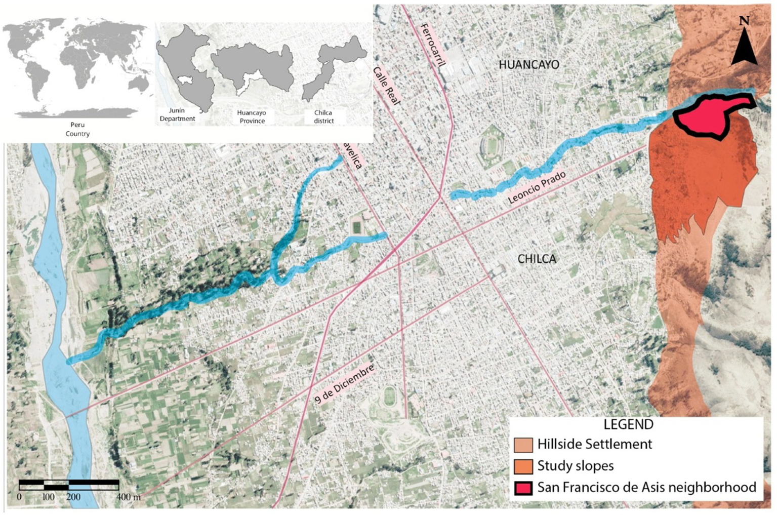
Location of the study area: San Francisco de Asís neighborhood, Ocopilla peasant community.
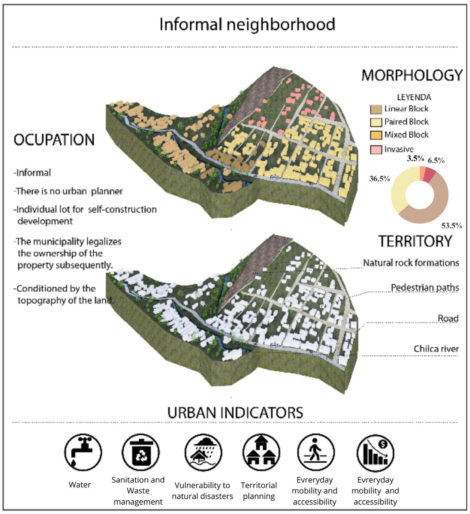
The Ocopilla community was chosen due to its complex and dynamic structure, characterized by formal and informal land occupation, land subdivision, and lot commercialization. These features make it a living laboratory for territorial studies (Figure 4). The selection is also justified by the presence of various social, economic, cultural, and regulatory challenges such as rural-to-urban migration, post-conflict impacts from the 1980s violence, land invasions, informal property markets, limited access to basic services, and diverse forms of vulnerability. The San Francisco de Asís neighborhood was selected as a case study due to its illustrative mix of formal and informal development and socio-territorial dynamics. To collect primary data, a questionnaire survey was administered to residents. Land occupation processes from 1990 to 2024 were analyzed using Google Earth imagery and the SUNARP geoviewer.
Figure 4
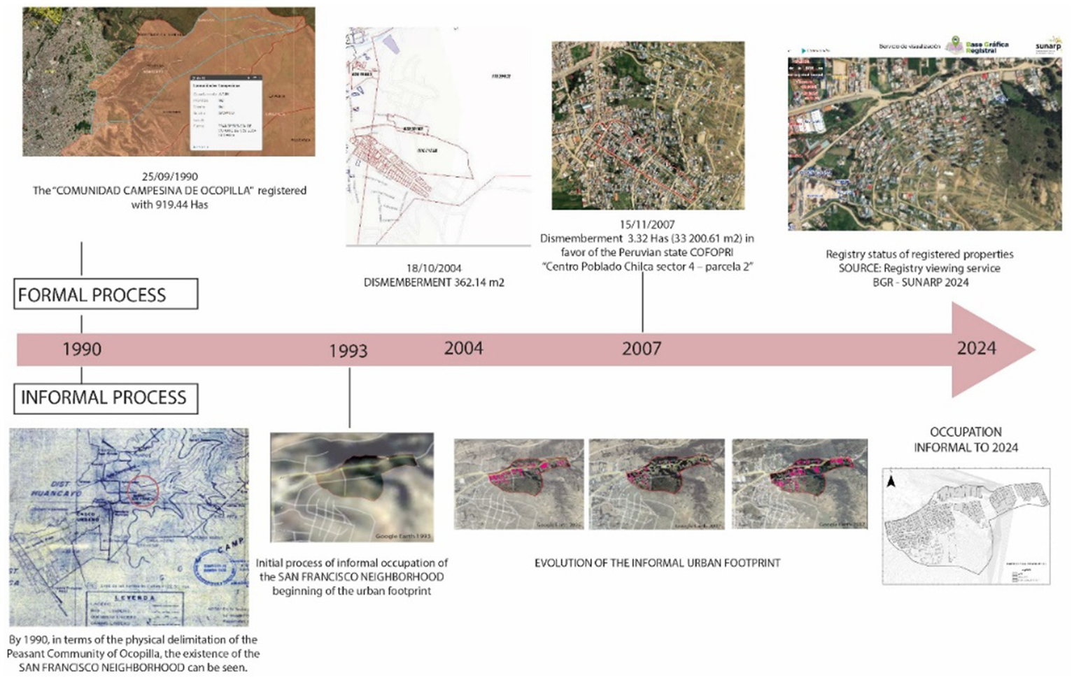
Process of communal land occupation in San Francisco de Asís neighborhood.
In Peru, informal settlements can exist within rural or peasant communities, according to two dominant theories: the indigenist thesis and the Hispanic thesis (Zevallos Yana, 2021). The urban–rural distinction is defined by population thresholds. INEI defines urban areas as those with 2,000 or more inhabitants, and rural areas as those with fewer. Mamani-Machaca (2021) suggests 15,000 as a more appropriate threshold for international comparisons, while other sources suggest 10,000 or 5,000 (INEI, 1996). This study thus considers peri-urban areas with informal dynamics under the framework of urban sustainability and planning (Figure 5). The questionnaire was reviewed by four experts and piloted with 30 property owners. Its content validity was assessed using Aiken’s V, with 95% confidence, while construct validity was evaluated with Pearson’s corrected correlation for ordinal Likert-type items. The instrument’s reliability was tested using Cronbach’s Alpha. The final sample included 50 homeowners from 170 registered households, based on a projected population of 850 residents across 16 blocks.
Figure 5
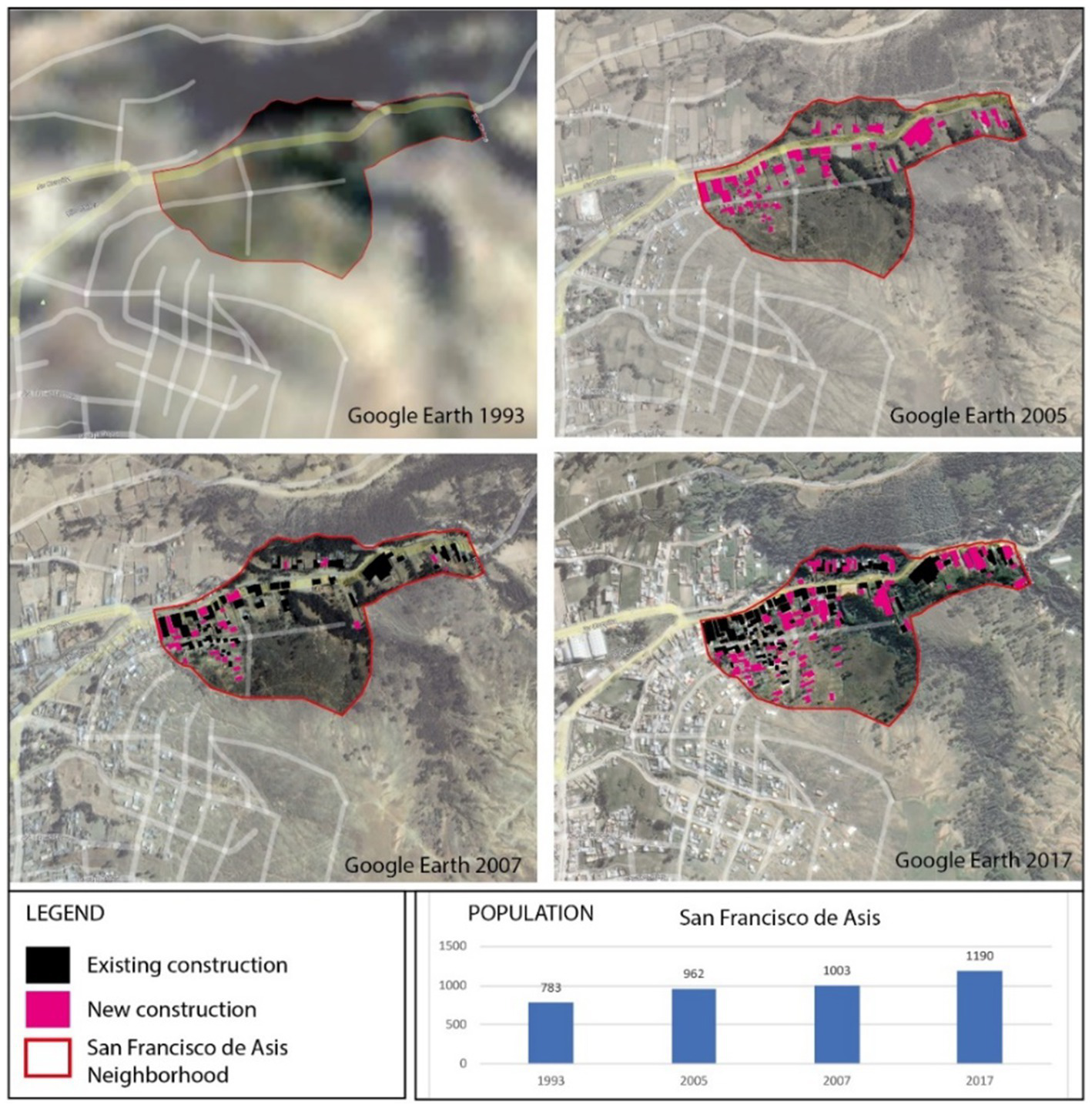
Evolution of the urban footprint of the San Francisco de Asís neighborhood according to INEI data (Lizmova and Cartógrafa, 2007).
We also considered regulatory frameworks such as Slum Law No. 13517 (1961), which addresses the remodeling, sanitation, and legalization of human settlements in urban and suburban areas. In Peru, land ownership in rural areas is established as collective property, with inalienability protections (Lambert, 2021; Riofrío, 1991). The methodological approach views the informal hillside neighborhood as an open-system and progressive urban transformation process (Sáez Giráldez, 2015). We used advanced geospatial technologies including ArcGIS, QGIS, Global Mapper, AutoCAD, and Civil 3D to analyze the territory across scales. Ecological territorial planning helped identify spatial trends using cartographic methods (Lopez et al., 2022). For neighborhood characterization, we drew on academic literature, regulatory documents (PAT-Huancayo, PDM, PDU-Chilca), and the IDB’s Action Plan. Data collection involved drone-based photogrammetry and historical maps (Google Maps, INEI censuses). A notable demographic increase occurred around 2017.
3 Results
3.1 Relationships between territorial occupation logic and the theoretical model of a sustainable neighborhood
The model proposed in this research is based on variables related to territorial occupation logic and the sustainable city model, applied to the context of the slopes of the La Esperanza neighborhood in the district of Chilca, Huancayo province. According to the diagnosis conducted by the BID ICES-Huancayo Action Plan (Granja Bastidas et al., 2017), Huancayo presents significant advantages, such as its low per capita water consumption, 100% renewable energy use, and low unemployment rates. However, critical areas requiring improvement were also identified, including education, security, health, citizenship, and expenditure management. Moreover, there are major challenges in water and sanitation, solid waste management, territorial planning, urban mobility, fiscal sustainability, and governance.
3.2 Improvement plan for informal neighborhoods and sustainability indicators
The study reveals a lack of previous experience with neighborhood improvement programs in developing countries like Peru, particularly in the study area, highlighting the need for improvement plans and sustainability indicators (Figure 6). For instance, in Lima, the Barrio Mío program (2012) aimed primarily at participatory planning, while in Huancayo, considered an emerging sustainable city by the BID ICES (2014), sustainability indicators were applied to the formal city but not to the informal neighborhoods located on the slopes of La Esperanza in Ocopilla, Chilca-Huancayo. According to Larios, Richter, and Samper (Granja Bastidas et al., 2017), the rapid diagnosis in Huancayo included an assessment of 23 themes and 117 indicators based on three methodological pillars of the CES program.
Figure 6
Indicator matrix for informal neighborhoods in the study area.
3.3 Territorial scalability
On the neighborhood scale, according to Granja Bastidas et al. (2017), urban processes range from the individual and housing scale to the macro-scale of the neighborhood and city. These multi-scale processes are crucial for understanding the causes and effects of urban inequality and for developing appropriate solutions. Simón-Rojo (2021) emphasizes that medium and small cities, as well as towns, share some responsibility in these processes but lack sufficient budgets and adequate professional teams. Therefore, the importance of the neighborhood scale is highlighted, which is largely unexplored by centralized governments despite its fundamental role in urbanization, economic, and social processes. The use of advanced technology, such as data processing through GIS, is required to obtain precise data, given that most state-provided data are of larger scales, limiting their applicability to the neighborhood scale.
The analysis focused on the San Francisco de Asís neighborhood, where the networks of vulnerable transversal logics affecting hillside neighborhoods were examined. The results indicate that 1,190 inhabitants of the San Francisco de Asís slum, comprising 170 households, benefited directly, according to the INEI censuses of 1993, 2005, 2007, and 2017. Additionally, the rural communities of Ocopilla and Azapampa, the Water and Sanitation Services Administration Boards (JASS), and neighboring neighborhoods benefited indirectly.
Figure 7 presents the neighborhood evaluation model, which incorporates theoretical aspects of neighborhood models grounded in the ecosystem approach. It also integrates a matrix of indicators tailored to the specific context and location, using a case study to analyze the complex relationship between environmental and urban sustainability indicators in informal settlements. Furthermore, the model is conceived as a progressive process and an open ecosystem, enabling the integration of new theories and context-specific indicators in response to the dynamic nature of informal hillside neighborhoods.
Figure 7
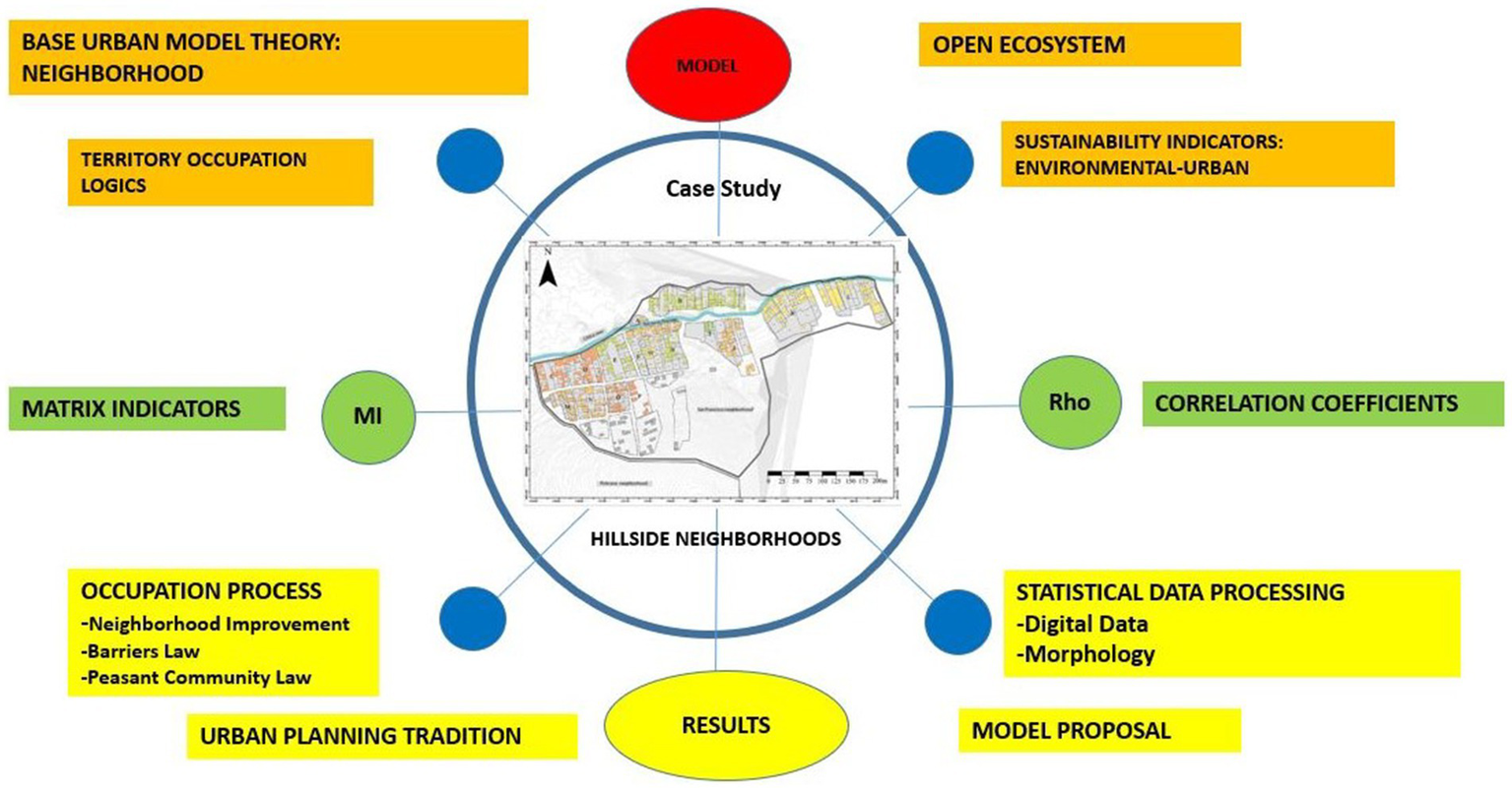
Diagram of the sustainable informal hillside neighborhood model.
3.4 Relationships of environmental and urban sustainability indicators
Regarding the indicator matrix, Navarro de Corcuera (2014) mentions that the Emerging Sustainable Neighborhoods Initiative (IBES) adapts to the Emerging Sustainable Cities Initiative (ICES). The application of the indicators at the neighborhood level focuses on habitability and territorial aspects, based on a comparison and selection of relevant IBES indicators and the scale of the theoretical model of a sustainable hillside neighborhood in San Francisco de Asís, Chilca district (Figure 6).
Figure 8 shows the distribution according to the interpretation of the occupation logic. These proportions reveal that 31% of the analyzed blocks (B, K, H, I), located predominantly in the central and northeastern parts of the San Francisco de Asís neighborhood, display a favorable perception concerning urban sustainability and quality of life. This finding suggests relative satisfaction with the infrastructure conditions, basic services, and community support in these areas, which potentially benefit from greater connectivity and access due to their proximity to the Chilca River, which runs through the neighborhood from north to south (Urquizo, 2004). However, 53% of the blocks (D, P, M, N, O, E, L), located primarily in the western and eastern areas of the neighborhood, present a situation of moderate or mixed dissatisfaction. These areas, further from the riverbank, may face greater challenges in terms of access to water resources, adequate infrastructure, and socioeconomic stability, suggesting the need for targeted interventions to improve living conditions, such as expanding basic service infrastructure and strengthening social inclusion policies. Particularly, Block J, which represents 8% of the total and is located in the center of the neighborhood near the Chilca River, is identified as a high-vulnerability area. This block is characterized by precarious access to services, inadequate land tenure legalization, and limited coverage of social programs, indicating an urgency for intervention to prevent the worsening of these conditions. The presence of the Chilca River, although a potential resource, may also contribute to the vulnerability of adjacent blocks due to flood risks or lack of adequate protective infrastructure. Therefore, the results underscore the need for a comprehensive and adaptive approach in urban policies that address both internal neighborhood disparities and risks associated with the natural environment, promoting an equitable distribution of resources and strengthening community resilience against complex urban challenges (Table 1).
Figure 8
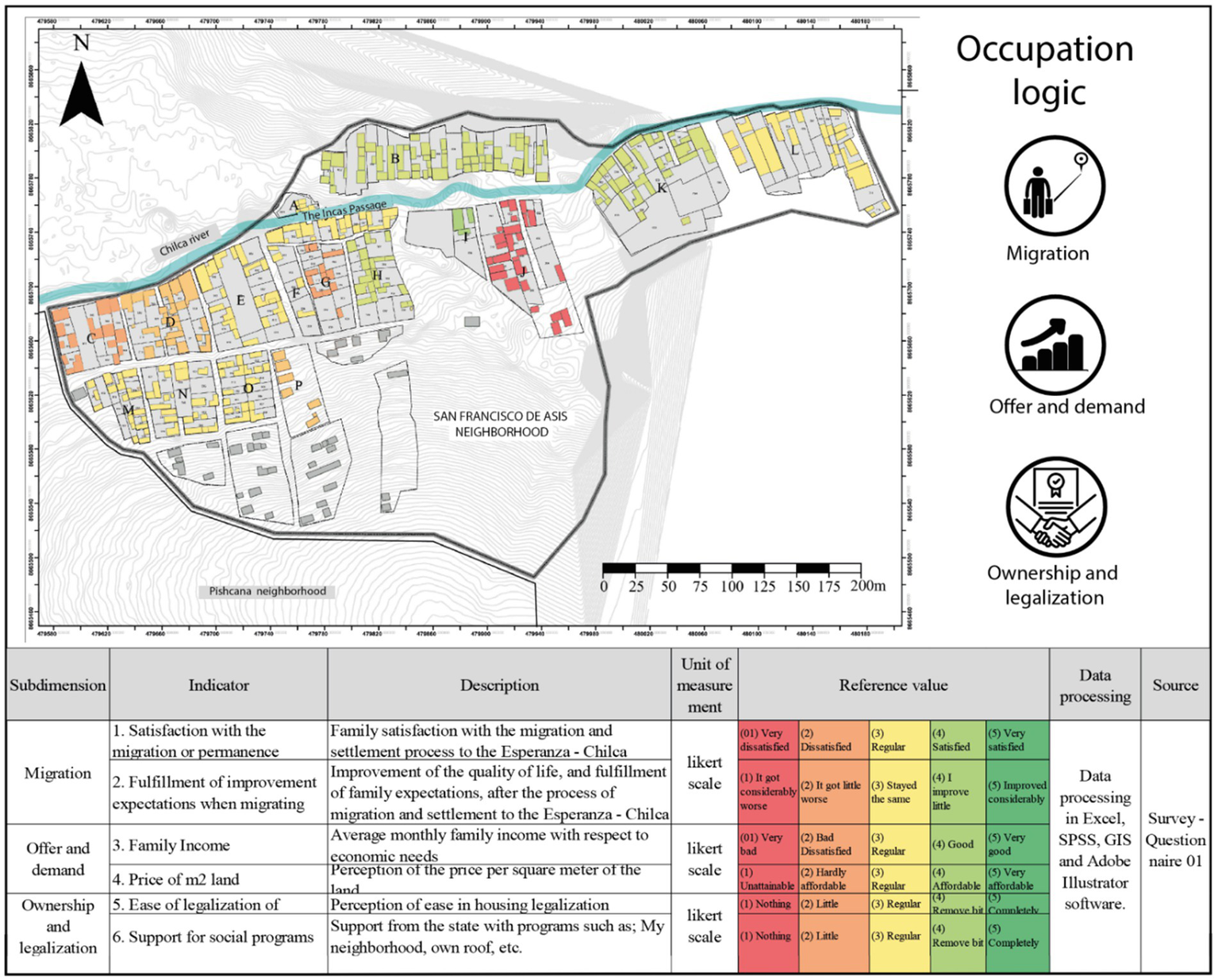
Graphical results and statistical relationship—occupation logic. The scores of the different indicators in Figures 8–10 are based on the evaluation of indicators, the variable operationalization matrix, and the questionnaire applied. A Likert scale was used to measure respondents’ perceptions on the topics addressed in this study. Additionally, a color-coded “traffic light” system was employed to visually represent the status of each indicator.
Table 1
| Variable | Ne1 | Ne2 | Me1 | Me2 | Es1 | Es2 |
|---|---|---|---|---|---|---|
| Ne1 | 1 | |||||
| Ne2 | −0.0062 | 1 | ||||
| Me1 | 0.9515 | 0.0902 | 1 | |||
| Me2 | −0.0086 | 0.3712 | 0.1716 | 1 | ||
| Es1 | 0.9277 | 0.0851 | 0.0615 | 0.0241 | 1 | |
| Es2 | 0.1529 | −0.0515 | 0.125 | 0.5779 | 0.213 | 1 |
Internal correlations of occupation logic.
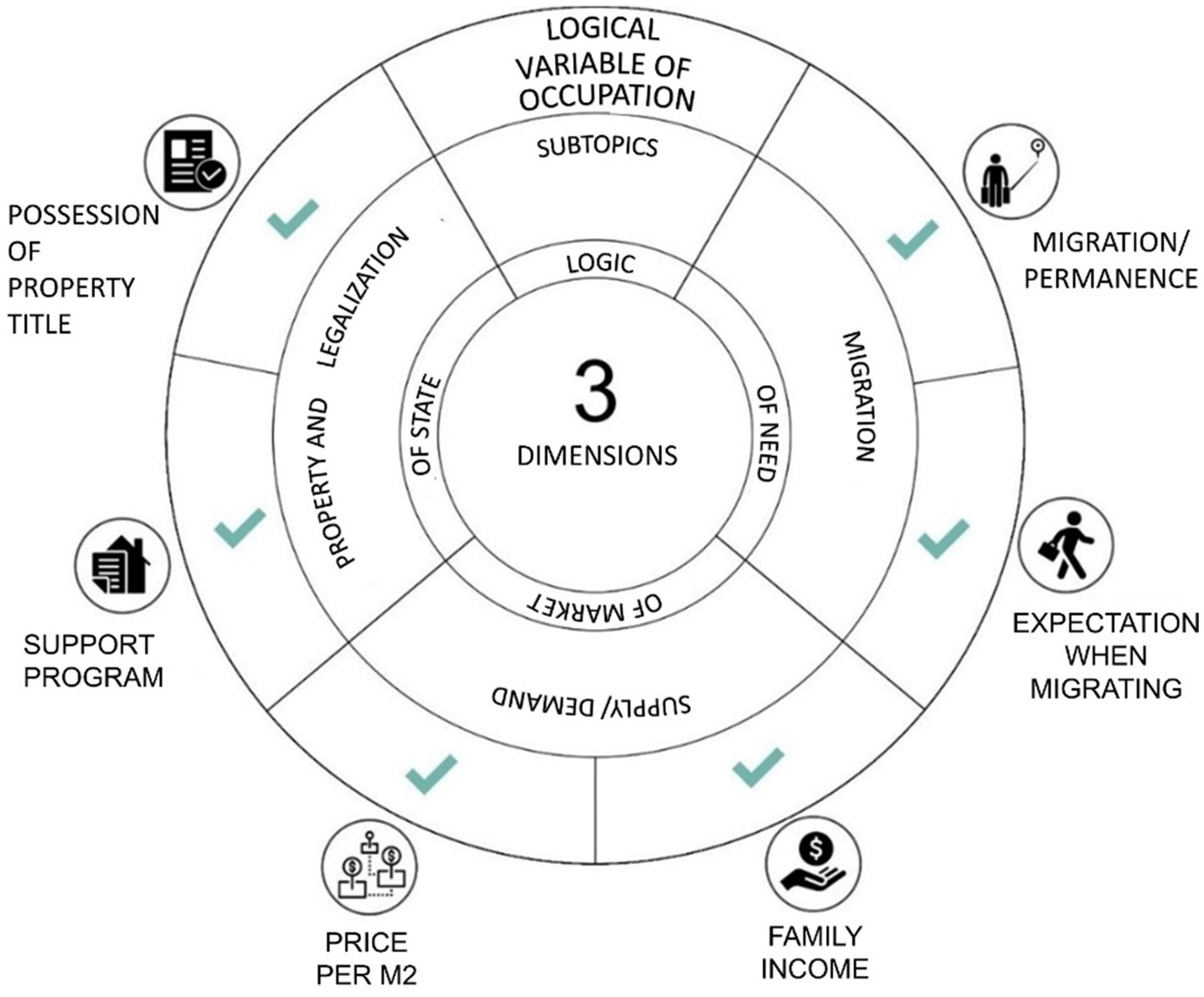
The abbreviations correspond to the operationalization of variables and the statistical analysis process of the study, including dimensions, subdimensions, and indicators. The “logic of necessity” dimension and its “migration” subdimension are represented by the abbreviations Ne1 and Ne2; the “logic of the market” dimension and its “supply” and “demand” subdimensions are represented by Me1 and Me2; and the “logic of the state” dimension with its “property” and “legalization” subdimensions are denoted as Es1 and Es2.
The results of the canonical correlation analysis are shown in Table 2, where the first three canonical correlations (0.4838, 0.2048, and 0.1098) indicate moderate to low associations between the linear combinations of the dependent and independent variables. The significance tests, particularly Pillai’s trace (p = 0.0488) and Lawley-Hotelling trace (p = 0.0484), present values close to the 5% significance level, suggesting a statistically significant relationship between the dimensions of occupation logic and the urban and environmental sustainability variables. Roy’s largest root (F = 4.7378, p = 0.0003) confirms a significant canonical correlation, suggesting that at least one of the canonical correlations is significant, underscoring the need for a multidimensional approach to understanding how market and state policies influence urban sustainability.
Table 2
| Description | Valor | ||||
|---|---|---|---|---|---|
| Number of Observations | 100 | ||||
| Canonical Correlations | 0.4838, 0.2048, 0.1098 | ||||
| Significance Test | Statistic | df1 | df2 | F | Prob > F |
| Wilks’ lambda | 0.724919 | 18 | 257.872 | 1.7257 | 0.0533 |
| Pillai’s trace | 0.288111 | 18 | 279 | 1.6467 | 0.0488 |
| Lawley-Hotelling trace | 0.361564 | 18 | 269 | 1.6106 | 0.0484 |
| Roy’s largest root | 0.305667 | 6 | 93 | 4.7378 | 0.0003 |
Canonical correlations and significance tests.
Figure 9 reveals that approximately 17% of the blocks (E and F), located south of the Chilca River and represented in dark color, show a notably negative perception regarding environmental sustainability. These blocks face significant challenges related to the coverage and quality of basic services, such as potable water and sanitation, possibly due to their distance from distribution sources and their location in topographically unfavorable areas. In contrast, 25% of the blocks (B, F, and I), situated closer to the riverbank and represented in light green, indicate a favorable perception of environmental sustainability. This suggests that proximity to the Chilca River facilitates better access to water resources and services, positively influencing the perception of water quality and availability and waste management efficiency. The blocks marked in yellow (K, L, and G), representing 20% of the total, reflect a mixed or moderately favorable perception, indicating acceptable conditions but still requiring improvements in infrastructure and resource management to achieve higher levels of sustainability. Meanwhile, 29% of the blocks (M, N, J in orange, and C, D in red) present a low or very low perception of environmental sustainability, located in areas further from the river. These blocks show high vulnerability to environmental risks, such as landslides and flooding, due to their location on unstable slopes and limited access to basic services. These findings underscore the need to prioritize interventions in the most vulnerable blocks to improve their access to basic services and reduce exposure to environmental risks, to promote greater equity and sustainability throughout the neighborhood.
Figure 9
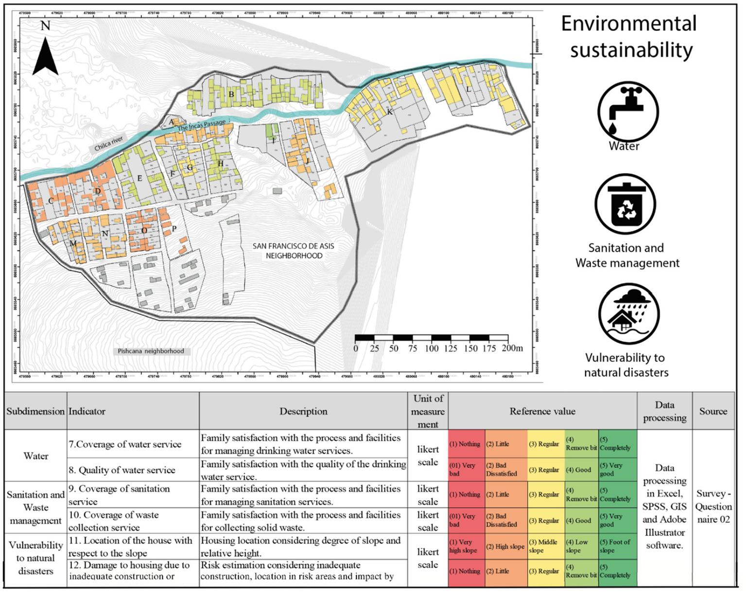
Graphical results and statistical relationship—environmental Sustainability.
Table 3 presents a canonical correlation analysis that explores the relationship between multiple variables associated with environmental sustainability in the context of the neighborhood under study. With a sample size of 100 observations, the first three canonical correlations obtained (0.4107, 0.1598, 0.0044) indicate that there is a moderate to weak association between the linear combinations of the dependent and independent variables related to environmental sustainability. The significance tests for the canonical correlations reveal important results: Wilks’ lambda statistic (λ = 0.81009, p = 0.0172) suggests that at least one of the canonical correlations is significantly different from zero, indicating a significant relationship between the sets of analyzed variables. Pillai’s trace (V = 0.194219, p = 0.0121) and Lawley-Hotelling trace (T = 0.229111, p = 0.0140) reinforce this evidence, indicating that there is a significant relationship between the canonical variables. Moreover, Roy’s largest root test (Θ = 0.202894, F = 6.4926, p = 0.0005) shows a highly significant result, indicating that the first canonical root has a considerable impact on explaining the observed variability in environmental sustainability in the study area.
Table 3
| Description | Valor | ||||
|---|---|---|---|---|---|
| Number of Observations | 100 | ||||
| Canonical Correlations | 0.4107, 0.1598, 0.0044 | ||||
| Significance Test | Statistic | df1 | df2 | F | Prob > F |
| Wilks’ lambda | 0.81009 | 9 | 228.922 | 2.2992 | 0.0172 (a) |
| Pillai’s trace | 0.194219 | 9 | 288 | 2.2151 | 0.0121 (a) |
| Lawley-Hotelling trace | 0.229111 | 9 | 278 | 2.359 | 0.0140 (a) |
| Roy’s largest root | 0.202894 | 3 | 96 | 6.4926 | 0.0005 (u) |
Canonical correlation analysis: environmental sustainability.
e = exact, a = approximate, u = upper limit of F.
Figure 10 shows the distribution of blocks in the San Francisco de Asís neighborhood in terms of urban sustainability, focusing on indicators such as territorial planning, urban inequality, daily mobility, and accessibility. Of the evaluated blocks, 71% are coded in yellow, indicating a moderate level of urban sustainability. These blocks, mostly located in areas near the Chilca River, show acceptable conditions in terms of access to basic services, proximity to paved roads, and land regularization. However, the moderation in the evaluation suggests that these blocks still face significant challenges, such as improving service quality and fully integrating urban planning policies. On the other hand, only one block (C) presents a favorable evaluation, coded in light green, indicating high urban sustainability with good access to infrastructure and services, likely due to its direct proximity to the center of the neighborhood and main roads. In contrast, two blocks (E and O) appear in red, representing areas with low urban sustainability. These blocks are vulnerable due to a lack of land regularization, high poverty levels, and poor infrastructure in terms of accessibility and connectivity. An additional block, N, in orange, shows an intermediate condition, highlighting the need for specific interventions to improve urban sustainability in these areas of the neighborhood.
Figure 10
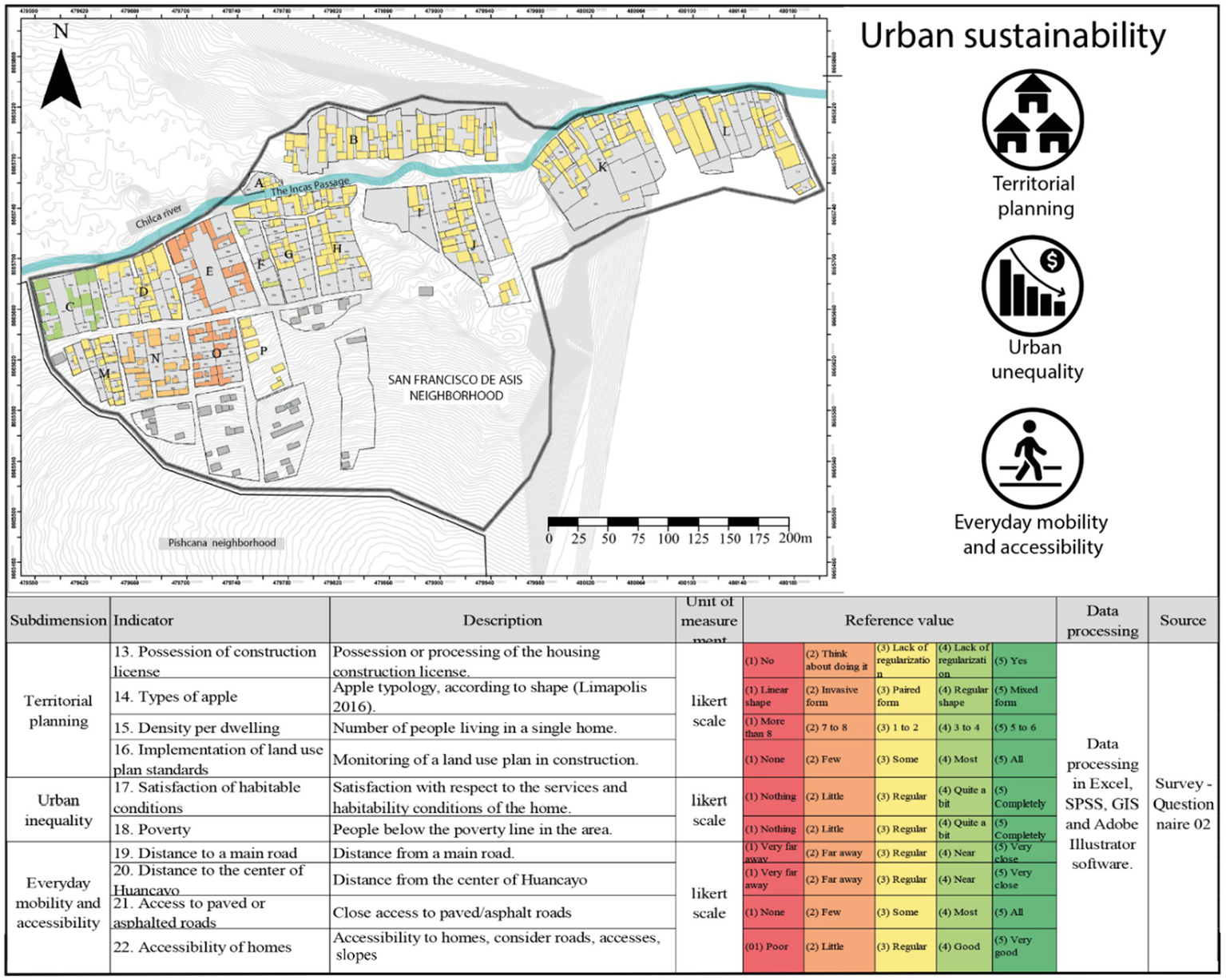
Graphical results and statistical relationship—urban sustainability.
Table 4 shows the results of the canonical correlation analysis to evaluate the relationship between different variables related to urban sustainability in the study area, using 100 observations. The obtained canonical correlations (0.3956, 0.0916, and 0.0127) suggest that the relationship between the linear combinations of dependent and independent variables is moderate to weak. The first canonical correlation (0.3956) indicates a moderate association, while the subsequent correlations are much lower, suggesting a weaker relationship between the remaining variables.
Table 4
| Description | Valor | ||||
|---|---|---|---|---|---|
| Number of Observations | 100 | ||||
| Canonical Correlations | 0.3956, 0.0916, 0.0127 | ||||
| Significance Test | Statistic | df1 | df2 | F | Prob > F |
| Wilks’ lambda | 0.836291 | 9 | 228.922 | 1.9338 | 0.0476 (a) |
| Pillai’s trace | 0.165048 | 9 | 288 | 1.8630 | 0.0573 (a) |
| Lawley-Hotelling trace | 0.194155 | 9 | 278 | 1.9991 | 0.0394 (a) |
| Roy’s largest root | 0.185553 | 3 | 96 | 5.9371 | 0.0009 (u) |
Canonical correlation analysis: urban sustainability.
e = exact, a = approximate, u = upper limit of F.
The significance tests reinforce these findings. Wilks’ lambda statistic (λ = 0.836291, p = 0.0476) indicates that at least one of the canonical correlations is significantly different from zero, suggesting a significant relationship between the analyzed urban sustainability variables. However, the significance is marginal, reflected in the values of Pillai’s trace (V = 0.165048, p = 0.0573) and Lawley-Hotelling trace (T = 0.194155, p = 0.0394), which show values close to the 5% significance level. This indicates that, although there is a significant correlation, the impact of these associations is not very strong. Roy’s largest root test (Θ = 0.185553, F = 5.9371, p = 0.0009) provides the most robust evidence of a significant relationship, indicating that the first canonical root has a considerable impact on the observed variability in urban sustainability. This result highlights that certain key factors in urban sustainability are closely related, suggesting the need for a strategic approach focused on the critical areas identified by this analysis.
4 Discussion
4.1 Impact of local conditions on the sustainability of informal neighborhoods
The sustainability of informal neighborhoods in Huancayo, specifically in the San Francisco de Asís neighborhood, is heavily influenced by local conditions of infrastructure, natural resources, and access to basic services. The quality and coverage of infrastructure in these neighborhoods play a critical role in promoting social cohesion and community participation, which are essential factors for sustainable development (Sharp and Warner, 2018; Yoo and Lee, 2016). In the study, the blocks near the Chilca River show a more favorable perception of urban sustainability due to better connectivity and accessibility provided by proximity to this natural resource. This finding aligns with previous studies indicating that well-planned infrastructure can enhance economic opportunities and social interaction among residents, while poor infrastructure tends to perpetuate social isolation and economic hardship (Mareeva et al., 2022; Zhang et al., 2018).
Moreover, the availability of natural resources, such as access to water and green areas, is fundamental to the sustainability of these neighborhoods. The results show that proximity to the Chilca River not only facilitates access to water resources but also influences the perception of quality of life and environmental sustainability. However, blocks located further away from the river face significant challenges, such as a shortage of drinking water and sanitation services, which negatively affects residents’ health and increases their vulnerability to natural disasters like floods and landslides (Arundel and Ronald, 2016; Mareeva et al., 2022). Additionally, inefficient management of these resources can compromise the ability of neighbors to cope with environmental stresses resulting from climate change, underscoring the need for effective and equitable resource management strategies.
Access to basic services such as water, sanitation, and healthcare is also a crucial determinant of sustainability in informal neighborhoods. Lack of adequate access to these services can exacerbate social inequalities and hinder community development (Brelsford et al., 2017; Honório et al., 2021). The study results demonstrate that blocks with better access to basic services tend to have more positive perceptions of urban sustainability, while those with limited access face greater challenges of poverty and marginalization, perpetuating cycles of vulnerability and social exclusion. This dynamic highlight the importance of developing inclusive policies that ensure an equitable distribution of resources and essential services to improve the quality of life in informal neighborhoods and promote their long-term sustainability.
However, we acknowledge that these findings are based on correlation analyses derived from quantitative data, and while they provide useful patterns, they may not fully capture the complexity of lived experiences in informal settlements. These neighborhoods are characterized by high heterogeneity and dynamic conditions that vary over time and space, often shaped by informal governance structures, socio-political history, and cultural context. Future studies should incorporate complementary qualitative methods—such as interviews, participatory mapping, or ethnographic observation—to validate and enrich the statistical results with grounded community insights.
4.2 Relationships between territorial occupation and sustainable urban development
Patterns of territorial occupation and their relationship with sustainable urban development practices in the San Francisco de Asís neighborhood reflect a complex interaction between land use, infrastructure, and community participation. This analysis is essential to promote sustainable urban environments in rapidly growing cities like Huancayo, where pressure on resources and development demand is high. The results of this study emphasize that the proposed neighborhood model in Huancayo serves as a practical framework for understanding the relevance of land use planning and the integration of sustainable practices within the broader scope of urban development. The existence of a significant correlation between dimensions of occupation logic, such as market and state (with a coefficient of 0.93), suggests that territorial management and urban planning should consider both economic aspects and public policies to foster balanced and sustainable development (Yigitcanlar and Dur, 2010). This is consistent with previous studies that emphasize the need to evaluate urban projects based on sustainability criteria to improve territorial management processes and increase the durability of urban infrastructure (Chastenet et al., 2016).
Furthermore, the design and layout of neighborhoods, as observed in the results, can either facilitate or hinder sustainable practices. For example, blocks with more direct access to the Chilca River showed a greater perception of sustainability, reinforcing the idea that accessibility to natural resources and basic services is fundamental to sustainable development. This finding aligns with the research by Chookah et al. (2021), which highlights the importance of evaluating sustainable neighborhoods to reduce uncontrolled urban sprawl, a significant challenge in areas of rapid urban growth. Implementing strategies such as the “15-min city,” which aims to improve access to essential services within a short walking distance (Enab, 2024), could be particularly effective in the context of informal neighborhoods like those in Huancayo.
The integration of green spaces and sustainable transportation options is another critical area for urban development in Huancayo. The research highlights that adequate access to green spaces and sustainable transport infrastructure is fundamental to improving urban sustainability and the quality of life for residents. This point is supported by the Urban Green Neighborhood Index, which provides a quantifiable measure of green spaces, essential for ecologically balancing densely populated urban environments (Gupta et al., 2012). In Huancayo, the lack of green spaces and limited transport infrastructure in some areas reflects the need for strategic interventions to foster more sustainable urban practices. Community participation and social sustainability are also key to shaping patterns of territorial occupation in Huancayo. The study results underscore the need for participatory approaches that consider the voices and needs of residents. This approach aligns with the argument by Dempsey et al. (2011) that community engagement in the urban planning process promotes a sense of belonging and responsibility, which can lead to more sustainable behaviors and practices within neighborhoods. This approach is particularly beneficial in areas with diverse populations, such as Huancayo, where it is crucial to address the varied needs and preferences of residents to achieve sustainable outcomes. Future studies should integrate in-depth qualitative fieldwork to better understand the lived realities, informal governance mechanisms, and local narratives that shape territorial occupation in these complex urban contexts.
4.3 Strategies to improve environmental and urban sustainability in vulnerable contexts
The results of this study suggest that implementing comprehensive and adaptive strategies is essential to improve environmental and urban sustainability in informal neighborhoods in the district of Chilca, Huancayo. Identified high-vulnerability areas, such as Block J, present conditions that require urgent interventions, especially in terms of access to basic services and strengthening community resilience. The integration of multisectoral approaches, such as the Water-Energy-Food (WEF) Nexus, can be key to addressing these needs. As indicated by Mabhaudhi et al. (2019), the interconnection between these sectors can improve livelihoods and the well-being of vulnerable communities. In the context of Huancayo, improving water management could not only increase agricultural productivity but also conserve energy, creating a holistic approach to sustainability. Additionally, the study results highlight the importance of urban planning supported by Geographic Information Systems (GIS) to optimize land use, transportation, and energy systems, reducing emissions and improving accessibility for vulnerable populations. This approach is supported by Carpentieri et al. (2019), who emphasize how GIS-based spatial analysis can significantly improve environmental quality in urban areas. In Huancayo, applying this methodology could help identify critical areas for intervention and design plans that integrate efficient land use with improvements in transport infrastructure, reducing vulnerability and increasing urban equity.
Incorporating green spaces and nature-based solutions also emerges as an effective strategy to improve urban sustainability in vulnerable contexts. Penteado (2024) and Kabisch et al. (2016) note that green spaces are essential for conserving biodiversity and enhancing the urban landscape, while nature-based solutions, such as urban forests and green roofs, can mitigate the effects of climate change and improve urban resilience. In Huancayo, where several blocks face high environmental vulnerability, such as those located on slopes far from the Chilca River, integrating these solutions could provide significant ecological and social benefits. Community participation is highlighted as a critical component for the success of sustainability initiatives. As Friche et al. (2015) argue, involving residents in decision-making processes ensures that interventions are more effective and accepted, as they are tailored to the specific needs of the community. In the study, the need for targeted interventions in the most vulnerable areas reinforces the importance of incorporating participatory approaches in urban planning to ensure that solutions are adequate and sustainable in the long term. While the present analysis emphasizes quantitative correlations between infrastructure deficits and vulnerability, future strategies must be grounded in participatory processes and qualitative insights from residents. This will help capture the nuances of informal urban life, especially in dynamic peri-urban and hillside environments.
Moreover, using sustainability indicators to guide urban policies is crucial to assess the impact of interventions and ensure that policies adapt to the changing needs of vulnerable neighborhoods. Canesi and Marella (2022) discuss the importance of using these indicators to evaluate resilience and urban sustainability in marginal regions. In the case of Huancayo, applying a locally developed set of indicators could help identify areas for improvement, such as access to clean water, sanitation, and green spaces, and monitor progress toward broader sustainability goals. However, it is important to interpret these indicators within the limitations of the research design and data scope. Complementary qualitative and longitudinal studies will be essential to validate these priorities over time and in different informal contexts.
5 Limitations
While this study successfully developed and applied an integrated evaluation model to analyze the complex relationship between environmental and urban sustainability in informal settlements, it faced certain methodological and scope-related limitations. First, the cross-sectional nature of the research limited the ability to conduct a longitudinal analysis, which would have been crucial for tracking the evolution of these neighborhoods over time and assessing the long-term impact of the factors studied. Although the geospatial approach and the analysis of basic service coverage revealed significant correlations with environmental vulnerability, the limited incorporation of qualitative methodologies may have restricted a deeper understanding of the complex social, cultural, and economic dimensions that shape informal occupation and development processes.
Second, while the model incorporated macro-level factors such as migration, market forces, and state policies, the depth of analysis regarding the specific interactions and causal relationships between these elements and urban sustainability may have been constrained by the study’s design and scope. Additionally, time constraints, limited access to disaggregated data, and logistical challenges during fieldwork posed practical limitations. The positionality of the authors—researchers with academic and planning experience in the study area—also influenced the interpretation and access to information, which, although beneficial, may have shaped the research perspective.
6 Conclusion
The results demonstrate that infrastructure, access to natural resources, and basic services are critical determinants of urban sustainability. Areas located closer to the Chilca River present better conditions, underscoring the importance of geographic location in resource access. Additionally, the integration of advanced technologies, such as Geographic Information Systems (GIS), and multisectoral approaches, such as the Water-Energy-Food (WEF) Nexus, is essential for designing effective and equitable interventions. Community participation also plays a key role in ensuring the effectiveness and social acceptance of policies, highlighting the importance of adopting a participatory approach to urban planning.
Furthermore, the use of sustainability indicators tailored to the local context enables continuous monitoring of policy impacts and facilitates the adjustment of strategies according to changing community needs. Recognizing the limitations of the study’s cross-sectional nature, it becomes essential to conduct future longitudinal research to understand the temporal evolution of these neighborhoods and assess the long-term sustainability of implemented interventions. Complementing quantitative analysis with qualitative methods will also enhance understanding of community perceptions and experiences, providing a stronger evidence base for inclusive and context-sensitive policy formulation.
This study offers an innovative contribution by proposing an integrated and adaptable neighborhood assessment model grounded in the ecosystem approach, which not only supports urban sustainability in informal hillside settlements but also holds potential for application in other territorial contexts facing similar socio-environmental challenges.
Statements
Data availability statement
The raw data supporting the conclusions of this article will be made available by the authors, without undue reservation.
Author contributions
JH-M: Conceptualization, Data curation, Formal analysis, Investigation, Methodology, Writing – original draft, Writing – review & editing. MC: Supervision, Validation, Writing – review & editing. JC-V: Formal analysis, Software, Writing – review & editing.
Funding
The author(s) declare that no financial support was received for the research and/or publication of this article.
Acknowledgments
We extend our gratitude to the National University of Central Peru for providing research facilities and to the Ocopilla Rural Community for their cooperation in conducting the research. Special thanks are also due to Bach. Rolando Quispe Merino, Emilio Cossio Sierra, and Mireya Huaman Abreg.
Conflict of interest
The authors declare that the research was conducted in the absence of any commercial or financial relationships that could be construed as a potential conflict of interest.
Generative AI statement
The author(s) declare that no Gen AI was used in the creation of this manuscript.
Publisher’s note
All claims expressed in this article are solely those of the authors and do not necessarily represent those of their affiliated organizations, or those of the publisher, the editors and the reviewers. Any product that may be evaluated in this article, or claim that may be made by its manufacturer, is not guaranteed or endorsed by the publisher.
References
1
Arundel R. Ronald R. (2016). The role of urban form in sustainability of community: the case of Amsterdam. Environ. Plan. B Urban Anal. City Sci.44, 33–53. doi: 10.1177/0265813515608640
2
Aulestia D. Lana B . (Coords.). (2024). Informe urbano de América Latina y el Caribe 2024. Comisión Económica para América Latina y el Caribe (CEPAL). Available online at: https://repositorio.cepal.org/handle/11362/81045 (Accessed September 2, 2024).
3
BID ICES . (2014). Implementación de la ICES en Huancayo – Programa Adicional. Proyecto PE-T1314. Retrieved from https://www.iadb.org/es/project/PE-T1314
4
Boldrini P. Malizia M. (2017). Informal urbanization in intermediate cities. The cases of greater San Salvador de Jujuy and greater San Miguel de Tucumán (Northwest Argentina). Cuaderno Urbano23:85. doi: 10.30972/crn.23233571
5
Brelsford C. Lobo J. Hand J. Bettencourt L. M. A. (2017). Heterogeneity and scale of sustainable development in cities. Proc. Natl. Acad. Sci.114, 8963–8968. doi: 10.1073/pnas.1606033114
6
Bush J. Doyon A. (2019). Building urban resilience with nature-based solutions: how can urban planning contribute?Cities95:102483. doi: 10.1016/j.cities.2019.102483
7
Canesi R. Marella G. (2022). Towards European transitions: indicators for the development of marginal urban regions. Land12:27. doi: 10.3390/land12010027
8
Carpentieri G. Zucaro F. Guida C. Granata L. (2019). GIS-based spatial analysis for the integrated transport-land use-energy planning: an application to greater London. J. Civil Eng. Archit.13, 663–675. doi: 10.17265/1934-7359/2019.11.001
9
Chastenet C. A. Belziti D. Bessis B. Faucheux F. Sceller T. L. Monaco F.-X. et al . (2016). The French eco-Neighbourhood evaluation model: contributions to Sustainable City making and the evolution of urban practices. J. Environ. Manag.176, 69–78. doi: 10.1016/j.jenvman.2016.03.036
10
Chookah N. A. Mushtaha E. Alsyouf I. Alkhalidi A. (2021). Sustainable neighborhood assessment: evaluating residential sustainability in Sharjah City’s old neighborhoods using the UN-Habitat’s sustainable neighborhood principles. Civil Eng. Archit.9, 1206–1216. doi: 10.13189/cea.2021.090422
11
Cities Alliance (2025). Slum upgrading is climate action: Experiences and insights from the global south. Brussels, Belgium: Cities Alliance Edn.
12
Contreras Gatica Y. Seguel Calderón B. (2022). Informal territory. A new reading of access to housing and land in Chile. Rev. Geografía Norte Grande136, 113–136. doi: 10.4067/s0718-34022022000100113
13
Dempsey N. Bramley G. Power S. Brown C. (2011). The social dimension of sustainable development: defining urban social sustainability. Sustain. Dev.19, 289–300. doi: 10.1002/sd.417
14
Enab D. (2024). Exploring an architectural paradigm for the 15-Minute City planning model: towards reforming gaps of Services in Nablus. An-Najah Univ. J. Res. A (Nat. Sci.)38, 67–76. doi: 10.35552/anujr.a.38.1.2164
15
FAO (2024). Repercusiones de los desastres en la agricultura y la seguridad alimentaria 2023: Evitar y reducir las pérdidas mediante la inversión en la resiliencia. Roma.
16
Farooq M. Mushtaq F. Meraj G. Singh S. K. Kanga S. Gupta A. et al . (2022). Strategic slum upgrading and redevelopment action plan for Jammu City. Resources11:120. doi: 10.3390/resources11120120
17
Fernandes E. (2011). Regularización de asentamientos informales en América Latina. Cambridge, MA, USA: Lincoln Institute of Land Policy.
18
Fort R. Benza Á. E. Rivero L. R. Molnárová J. (2017). Otro Urbanismo. Para Lima: PUCP.
19
Friche A. A. D. L. Dias M. A. D. S. Reis P. B. D. Dias C. S. Caiaffa W. T. (2015). Urban upgrading and its impact on health: a “quasi-experimental” mixed-methods study protocol for the BH-viva project. Cad. Saude Publica31, 51–64. doi: 10.1590/0102-311X00079715
20
García-Pelayo M. (1975). La teoría general de sistemas. Rev. Occidente2, 52–59.
21
Geddes S. P. Vallina M. M. (2009). Ciudades en evolución. Oviedo, Spain: KRK Ediciones.
22
González-González M. J. (1979). The sustainable city. Planning and systems theory. Bulletin of the Association of Spanish Geographers. Available online at: https://bage.age-geografia.es/ojs/index.php/bage/article/view/417 (Accessed August 28, 2024).
23
Granja Bastidas M. B. Cuenca Gonzaga M. Meza A. G. (2017). La ciudad paso a paso: Métodos de interacción para la configuración de barrios informales desde sus propias lógicas. En IX Seminario Internacional de Investigación en Urbanismo, Barcelona-Bogotá, Junio 2017. Barcelona: DUOT.
24
Gupta K. Kumar P. Pathan S. K. Sharma K. (2012). Urban neighborhood green index – a measure of green spaces in urban areas. Landsc. Urban Plan.105, 325–335. doi: 10.1016/j.landurbplan.2012.01.003
25
Haou E. Allarané N. Aholou C. C. Bondoro O. (2025). Integrating sustainable development goals into urban planning to advance sustainability in sub-Saharan Africa: barriers and practical solutions from the case study of Moundou, Chad. Urban Sci.9:22. doi: 10.3390/urbansci9020022
26
He J. Chen H. Cai Y. Li Z. Ye J. (2025). From urban village housing to tenant mental health: the crucial role of community attachment in Chinese megacities. Front. Public Health13:1490105. doi: 10.3389/fpubh.2025.1490105
27
Honório O. S. Pessoa M. C. Gratão L. H. A. Rocha L. L. de Castro I. R. R. Canella D. S. et al . (2021). Social inequalities in the surrounding areas of food deserts and food swamps in a Brazilian Metropolis. Int. J. Equity Health20:168. doi: 10.1186/s12939-021-01501-7
28
INEI (1996). National Censuses 1993: IX population and IV housing. Lima: INEI.
29
IPCC (2023). “Summary for policymakers” in Climate change 2023: Synthesis report. Contribution of working groups I, II and III to the sixth assessment report of the intergovernmental panel on climate change. eds. Core Writing Team, LeeH.RomeroJ. (Geneva, Switzerland: IPCC), 1–34.
30
Kabisch N. Frantzeskaki N. Pauleit S. Naumann S. Davis M. Artmann M. et al . (2016). Nature-based solutions to climate change mitigation and adaptation in urban areas: perspectives on indicators, knowledge gaps, barriers, and opportunities for action. Ecol. Soc.21, 39. doi: 10.5751/ES-08373-210239
31
Kaiser Z. R. M. A. Akter F. (2025). From risk to resilience and sustainability: addressing urban flash floods and waterlogging. Risk Sci.1:100011. doi: 10.1016/j.risk.2025.100011
32
Kiss B. Sekulova F. Hörschelmann K. Salk C. F. Takahashi W. Wamsler C. (2022). Citizen participation in the governance of nature-based solutions. Environ. Policy Gov.32, 247–272. doi: 10.1002/eet.1987
33
Lambert R. (2021). Examining the relationship between planning and peripheral urbanization in Lima. Revista de arquitectura, urbanismo y territorio.
34
Lizmova N. Cartógrafa I. (2007). Map analysis is a method of investigation of natural and socioeconomic phenomena.
35
Lopez V. Álvarez J. P. Morales M. Rosales C. (2022). Return to school in person: Recommendations for the promotion of social-emotional well-being and the prevention of school violence. PACES Resources for school coexistence. Available online at: https://recursos.paces.cl/bienestar/retorno-presencial-a-clases-recomendaciones-para-la-promocion-del-bienestar-socioemocional-y-la-prevencion-de-la-violencia-escolar/ (Accessed August 28, 2024).
36
Mabhaudhi T. Nhamo L. Mpandeli S. Nhemachena C. Senzanje A. Sobratee N. et al . (2019). The water–energy–food Nexus as a tool to transform rural livelihoods and well-being in southern Africa. Int. J. Environ. Res. Public Health16:2970. doi: 10.3390/ijerph16162970
37
Mahabir R. Crooks A. Croitoru A. Agouris P. (2016). The study of slums as social and physical constructs: challenges and emerging research opportunities. Reg. Stud. Reg. Sci.3, 399–419. doi: 10.1080/21681376.2016.1229130
38
Mamani-Machaca H. M. (2021). El sistema urbano del Perú al inicio del siglo XXI, 2007-2017. Semestre Econ.10, 4–17. doi: 10.26867/se.2021.v10i1.108
39
Mar J. M. (1977). Las barriadas de Lima: 1957. Instituto de Estudios Peruanos.
40
Mareeva V. M. Ahmad A. M. Ferwati M. S. Garba S. B. (2022). Sustainable urban regeneration of blighted neighborhoods: the case of Al Ghanim neighborhood, Doha, Qatar. Sustainability14:6963. doi: 10.3390/su14126963
41
Morandin Ahuerma I. Contreras Hernández A. (2017). Sustainability: ethics, complexity and transdiscipline (p. 294).
42
Moyano Molina A. M. (2015). Architecture in degraded fabrics of high vulnerability: 'from chaos to order, from simplicity to complexity, from dispersion to structuring, from improbability to probability and from ignorance to knowledge'. [Phd, E.T.S. Arquitectura (UPM)]. Available online at: https://oa.upm.es/42928/ (Accessed August 28, 2024).
43
Navarro de Corcuera L. (2014). Methodological guide: Emerging and sustainable cities initiative: Inter-American Development Bank.
44
Navarro L . (2017). IBES/Iniciativa de Barrios Emergentes y Sostenibles. Herramientas aplicadas para la regeneración de áreas vulnerables. Caso de estudio-aplicación en Cancino Adentro, Santo Domingo Este. [Master’s thesis, Centro de Innovación en Tecnología para el Desarrollo Humano, itdUPM].
45
Nguyen T. T. T. Waibel M. (2021). Urban Heat Islands and implications for Vietnam. En BriesenD.MinhP. Q. (Eds.), Environmental policy in Vietnam (No. 2, pp. 117–127). Hanoi, Vietnam: Thanh Nien Publishing House.
46
Penteado H. M. (2024). Where did they go? Understanding the Effects of Urbanization on Bird Diversity in a Brazilian Coastal City.
47
Riofrío G. (1991). Producing the (popular) city of the '90s: Between the market and the state. Lima, Peru: Center for Development Studies and Promotion.
48
Rodríguez Rivero L. Muñoz Unceta P . (2017). The city of the slopes: Workshop Limapolis 2016. 14 project strategies, workshop: The city of the slopes: Workshop Limápolis 2016. Housing, city and society, essays. Pontifical Catholic University of Peru, Fondo Editorial.
49
Romero-Martínez S.-A. (2021). El ecobarrio como alternativa para el mejoramiento urbano de asentamientos informales. Papeles de Coyuntura47, 170–208.
50
Sáez Giráldez E. (2015). Una lectura de los asentamientos humanos de Lima. Madrid, Spain: Universidad Politécnica de Madrid.
51
Sharp G. Warner C. (2018). Neighborhood structure, community social organization, and residential mobility. Socius Sociol. Res. Dynamic World4:237802311879786. doi: 10.1177/2378023118797861
52
Sierra A. P. C. Solano A. S. A. Lozano D. H. (2024). Understanding urban densification in Latin American cities: determinants of the production of built space in informal areas in Bogota (2007-2018). Cities148:104839. doi: 10.1016/j.cities.2024.104839
53
Simón-Rojo M. (2021). Powering transformative practices against food poverty with urban planning. Urban Agric. Reg. Food Syst.6:e20021. doi: 10.1002/uar2.20021
54
Son T. H. Weedon Z. Yigitcanlar T. Sanchez T. Corchado J. M. Mehmood R. (2023). Algorithmic urban planning for smart and sustainable development: systematic review of the literature. Sustain. Cities Soc.94:104562. doi: 10.1016/j.scs.2023.104562
55
Takyi S. A. Amponsah O. Darko G. Peprah C. Apatewen Azerigyik R. Mawuko G. K. et al . (2022). Urbanization against ecologically sensitive areas: effects of land use activities on surface water bodies in the Kumasi Metropolis. Int. J. Urban Sustain. Dev.14, 460–479. doi: 10.1080/19463138.2022.2146121
56
UN-Habitat , (2015). Temas Hábitat III 22: Asentamientos informales. Available online at: https://habitat3.org/wp-content/uploads/Issue-Paper-22_ASENTAMIENTOS-INFORMALES-SP.pdf (Accessed April 5, 2025).
57
UN-Habitat (2024). Monitoring smart inclusive transitions for an equitable urban future, using global urban monitoring framework. United Nations human settlements programme.
58
Urquizo W. L. (2004). Lima: Historia y urbanismo en cifras, 1821–1970. Alemania: Ministerio de Vivienda, Construcción y Saneamiento.
59
Vera F. , y SordiJ. (2021). Diseño ecológico: Estrategias para la ciudad vulnerable: Adaptando las áreas precarias de América Latina y el Caribe al cambio climático.
60
Yamagata Y. Sharifi A. (2018). Resilience-oriented urban Planning: theoretical and empirical insights: Springer.
61
Yigitcanlar T. Dur F. (2010). Developing a Sustainability Assessment Model: The Sustainable Infrastructure, Land-Use, Environment and Transport Model. Sustainability, 2, 321–340.
62
Yoo C. Lee S. (2016). Neighborhood built environments affecting social capital and social sustainability in Seoul, Korea. Sustainability8:1346. doi: 10.3390/su8121346
63
Zevallos Yana J. F. (2021). Para entender a las comunidades campesinas en el bicentenario: Una descripción local. Rev. Facultad Derecho Ciencias Políticas (Cusco)4, 173–186. doi: 10.51343/rfdcp.v4i13.956
64
Zhang Q. Yung E. H. Chan E. H. (2018). Towards sustainable neighborhoods: challenges and opportunities for neighborhood planning in transitional urban China. Sustainability10:406. doi: 10.3390/su10020406
Summary
Keywords
environmental vulnerability, informal settlements, territorial occupation, urban policy, urban sustainability
Citation
Hinostroza-Martinez J, Custodio M and Chavez-Villarroel J (2025) Ecosystem approach to sustainable neighborhoods: applicability of environmental and urban sustainability indicators in informal neighborhoods. Front. Sustain. Cities 7:1518694. doi: 10.3389/frsc.2025.1518694
Received
28 October 2024
Accepted
05 May 2025
Published
27 May 2025
Volume
7 - 2025
Edited by
Prudence Khumalo, University of South Africa, South Africa
Reviewed by
Marco Rossitti, Polytechnic University of Milan, Italy
Ruth Massey, University of Huddersfield, United Kingdom
Updates
Copyright
© 2025 Hinostroza-Martinez, Custodio and Chavez-Villarroel.
This is an open-access article distributed under the terms of the Creative Commons Attribution License (CC BY). The use, distribution or reproduction in other forums is permitted, provided the original author(s) and the copyright owner(s) are credited and that the original publication in this journal is cited, in accordance with accepted academic practice. No use, distribution or reproduction is permitted which does not comply with these terms.
*Correspondence: Jose Hinostroza-Martinez, jhinostroza@uncp.edu.pe
Disclaimer
All claims expressed in this article are solely those of the authors and do not necessarily represent those of their affiliated organizations, or those of the publisher, the editors and the reviewers. Any product that may be evaluated in this article or claim that may be made by its manufacturer is not guaranteed or endorsed by the publisher.