Abstract
Peri-urban areas constitute their own spatial system; a new rhizomatic city that brings together a heterogeneous mosaic of identities, uses and relationships. These ecologically and programmatically rich contexts are fluid, dynamic and ambiguous. As a result, urban planning has not generally produced satisfactory solutions for structuring these environments. In the absence of a coherent spatial strategy and institutional framework capable of re-composing peri-urban areas, architecture emerges as a tool capable of responding to the fluid and mutating character of these apparently chaotic landscapes. This paper analyses how contemporary architecture can enhance the coherence of peri-urban areas at a territorial scale through specific interventions. By exploring five case studies, it takes the architectural project as a working tool and explores some design strategies that can be effective in peri-urban contexts. The case studies share several characteristics that enable them to have a transformative impact on peri-urban areas. First, they function across the multiple scales of the peri-urban landscape. Second, they demonstrate a capacity to redress fragmentation and address diversity. Third, they signify the peri-urban landscape by constructing a new centrality on a territorial scale. Fourth, they assume the mutant condition of peri-urban environments through supports that offer programmatic indeterminacy. Five, they operate as infrastructural artifacts.
1 Introduction
Rauws and de Roo (2011) describe peri-urban areas as a kind of transition zone between the rural and urban, forming an interface between the two. They argue that the peri-urban landscape emerges through a process in which rural areas on the outskirts of a city gradually become urban in formal, economic and social terms. A binary interpretation of the peri-urban landscape, based on a rigid and artificial distinction between the ‘urban’ and the ‘rural’, leads to an analysis that focuses only on the limitations of these areas. The process of peri-urbanization is understood as urban encroachment on rural land, commonly producing a loss of ‘rural’ aspects (fertile soils, agricultural land, natural landscapes, etc.). In the same moment that these positive elements are erased, low density, lack of accessibility, lack of services and infrastructure, etc. are challenges in terms of urbanization.
An alternative to this dichotomous view is to understand the peri-urban areas as a ‘third space’. We base this term on Clement’s concept of a ‘third landscape’ (Clément, 2004). These are areas where natural ecosystems emerge spontaneously and are richer than ecosystems created in planned environments. Accordingly, we understand peri-urban ‘third spaces’ as complex urban developments occurring in spaces that are neither purely rural nor purely urban, but rather spatial systems in their own right. They are fluid landscapes in constant evolution which bring together a heterogeneous mosaic of ecological, agricultural and urban identities and functions (Sieverts, 2003). Thus, the peri-urban should not be understood as being ‘between’ two forces, but rather as a domain in which a dynamic system involving complex sets of relationships results in high levels of fluidity. Peri-urban areas exhibit a combination of land uses, which are neither rural nor urban in the conventional sense (Ravetz et al., 2013). This dynamism and ambiguity make characterizing these areas a complicated proposition.
1.1 Peri-urbanization of the territory
Peri-urban areas are a manifestation of what Koolhaas has called the ‘generic city’ (Koolhaas, 1995). Koolhaas suggests that the ‘generic city’ is the result of the global forces shaping contemporary urbanism. Thus, over recent decades, areas have become subject to a progressive standardization and loss of uniqueness (Pace and Mughini Gras, 2024). These delocalized environments are places which have been occupied by infrastructures and architectures common to any peri-urban landscape in the world, and resultantly their identity and local cultural traditions have been diluted.
The peri-urban system produces environments that are structured completely differently from conventional ones. This can make them appear diffuse and disorganized at first glance (Secchi, 2002). They may have many functionally specialized areas, networks and nodes, but no clear center (Sieverts, 2003). Through accelerated, spatially differentiated patterns of urbanization, peri-urban landscapes produce dynamic, multifaceted transition zones at the edges of urban centers. In this sense, Woltjer argues that a specific feature of peri-urbanization has been a global transition from cities to wider urban regions, produced through the direct interconnection of flows of people, goods and communications (Woltjer, 2014). This has produced a rhizomatic system of networks and nodes (Sassen, 2001).
1.2 The difficulty of planning in a peri-urban landscape
The production of peri-urban areas is the result of co-evolutionary interactions between processes at multiple scales (Rauws and de Roo, 2011). The nature of these interactions cannot be fully understood by analysing them individually, as the evolutionary development of peri-urban areas depends on self-reinforcing interactions between local, place-specific elements and decontextualized processes at a supra-regional scale. Thus, peri-urban areas can host agricultural production linked to the traditional way of life of the territory, industrial facilities, transport network infrastructure on a national or supranational scale, and new decontextualized leisure centers dependent on transport networks (Woltjer, 2014). As a result of this unstructured implantation of new uses, a landscape of fragmented and dispersed spaces with mixed uses is generated in areas that were, until recently, rural. In these environments, road and rail infrastructures and residential and industrial uses intermingle with natural and agricultural spaces, producing a new landscape that is remarkably heterogeneous and complex (Allen, 2003). Peri-urban landscapes typically evolve rapidly. Boundaries shift constantly and new spatial functions and land use types emerge due to competition between consumption and production activities (Garreau, 1991). The fluid character of the peri-urban landscape affects the socio-demographic structure of these areas. Social groups are generally heterogeneous and in constant transition in a process characterized by the continual incorporation of new actors (Allen, 2003). Apparatus that escape the control and regulation of urbanism often proliferate in these environments (Agamben, 2009).
Planning in peri-urban areas poses significant challenges due to the difficulty of clearly defining these zones, the uncertainty surrounding land use, and the frequent changes in administrative boundaries (Mortoja et al., 2020). As Allen (2003) explains, ‘peri-urban areas often share territory of more than one administrative unit’, and therefore, they can commonly be characterized ‘as the converging of sectoral and overlapping institutions with different spatial and physical remits. Allen (2003) goes on to argue that the environmental planning and management of peri-urban areas requires a combination of methods that strike a balance between local planning and broader regional urban planning. Woltjer (2014), for his part, advocates strengthening local government capacities, cross-sectoral integration to generate new governance, regional and inter-municipal coordination, and readapting the territorial boundaries of regions.
The ecosystemic, socio-demographic and institutional complexity of peri-urban areas, and their rapid and constant transformation means that different planning and institutional interests often contradict each other and come into conflict. This makes coordination and reconciliation particularly complex. Some authors, such as Silva, go so far as to argue that contemporary planning policies have failed to promote alternative ways of managing peri-urban areas (Silva, 2019). Relatedly, Rauws and de Roo argue that peri-urban development cannot be managed solely through traditional command-and-control approaches, and that other ways of addressing the challenge are necessary (Rauws and de Roo, 2011).
1.3 Architecture as an alternative
In the absence of a coherent spatial strategy or institutional framework capable of re-composing peri-urban systems, architecture can operate as a tool with the capacity to respond to the fluid and mutating nature of these apparently chaotic landscapes. This paper focuses on architecture as an agile and powerful tool that, through limited formal interventions, can shape the character of peri-urban areas. Aureli states that, ‘the possibility of an absolute architecture is thus both the possibility of making the city and also the possibility of understanding the city and its opposing force – urbanization – through the very finite nature of architectural form’ (Aureli, 2011, p. xiv). Taking Aureli’s argument as a point of departure, our research aimed to investigate how architectural projects can offer an alternative vision for the peri-urban city-region (Aureli, 2011). Specifically, the objective was to analyse specific interventions which take territorial scale into account and lend coherence to peri-urban areas. These architectural projects go beyond the fulfillment of limited functional requirements and help shape the surrounding territory. In this sense, the architectural projects analysed understand that the limits of an architectural object extend far beyond the physical boundary of the construction. Instead, they play an infrastructural role over a wider area. Thus, the common feature of the case studies presented here is their attempt to address both architectural and territorial scale. The paper seeks to identify the common features of these types of architectural projects and propose a compendium of design strategies applicable in peri-urban settings.
2 Methods
The analysis of architectural projects employed a qualitative research method, which aimed to construct a ‘rich and meaningful snapshot of a complex and multifaceted situation’ (Muratovski, 2016, p. 95). In this case, our research describes and interprets a series of architectural projects located in or planned for peri-urban settings. These projects share a common ambition to redefine and restructure place, and become nuclei that connect different scales. Case study analysis is a valuable tool with which to approach a complex phenomenon, such as architectural intervention in peri-urban contexts, using a wide variety of data (Baxter and Jack, 2008).
The initial phase of the research involved the identification and selection of case studies. To guide this process, we established four primary criteria to identify appropriate multi-scalar hybrid projects in peri-urban landscapes. These criteria included: (a) the proposal of a coherent alternative to conventional urban planning approaches; (b) the capacity to operate across multiple spatial scales, from the neighborhood to the regional; (c) the ability to activate and structure underutilized or vacant peri-urban spaces; and (d) the implementation of carefully considered architectural strategies able to generate coherence in fragmented peri-urban contexts. These criteria served as the basis for an initial selection of relevant projects. Ultimately, five case studies were chosen based on their international recognition and the volume of primary and secondary documentation available. The selection also aimed to encompass the broadest possible temporal range, ensuring a diverse and representative sample.
The second phase involved gathering information on each case study. The sources consulted were primarily the architects’ websites, monographs on their work, and print and online architectural journals. Information was collected systematically, focusing on three key aspects: the contextual framework of each case study, the projects’ interaction with their peri-urban surroundings, and the spatial and formal attributes inherent to the architectural design.
Finally, we analysed the data. We employed a five-step process: chronologically arranging the case studies, categorizing, interpreting, identifying differences and common patterns, and finally, synthesizing and generalizing the design strategies used in peri-urban contexts.
3 Results
Architectural interventions in peri-urban contexts that challenge conventional urban planning approaches are characterized by multi-scalar design strategies and the intentional incorporation of urban voids as meaningful spatial elements within the urban fabric. These architectural projects lend coherence to peri-urban areas through specific and strategic interventions, while maintaining a territorial scale perspective. These architectural projects therefore have a significant impact on the territory, as they connect and create flows, and redress turban voids and the fragmentation of peri-urban environments. We compiled an initial list of eighteen architectural projects demonstrating these characteristics dating from the mid-20th century to the present (Table 1).
Table 1
| Project | Country | Author/s | Year |
|---|---|---|---|
| University of Sheffield | UK | Alison and Peter Smithson | 1953 |
| Berlín Hauptstadt | Germany | Alison and Peter Smithson | 1957 |
| Fulham Study | UK | Archigram | 1963 |
| Bellinzona Bathhouse | Switzerland | Aurelio Galfetti | 1967 |
| Gymnasium Bridge | USA | Steven Holl | 1976 |
| Congrexpo Lille | France | OMA/Rem Koolhaas | 1988 |
| ZKM Karlsruhe | Germany | OMA/Rem Koolhaas | 1989 |
| Zaanstadt | Netherlands | NL Architects | 2005 |
| Eichbaum Temporary Opera | Germany | RaumlaborBerlin | 2009 |
| Easier Taken Slow (Tirana-Durrës) | Albania | DOGMA studio | 2014 |
| Comunal Villa | (indeterminate) | DOGMA studio | 2015 |
| BLOX/DAC | Denmark | OMA/Rem Koolhaas | 2028 |
| Southbank | UK | Carmody-Groarke | 2019 |
| Pool is Cool | Belgium | Flow | 2021 |
| Hage-Lund | Sweden | Brendeland & Kristofersen | 2021 |
| Bijgaardehof | Belgium | Bogdan & Van Broeck | 2022 |
| Horta Market | Spain | Carles Enrich | 2023 |
| Palais des Expositions de la Ville de Charleroi | Belgium | AgwA | 2024 |
List of peri-urban architectural projects.
From this initial list we selected five case studies. Our final sample included works at different scales and from time periods. It also focused on projects that have been extensively discussed in the specialized literature, as this ensured that enough information was available to conduct a deeper level of analysis.
3.1 Case study 1: Bellinzona Bathhouse (Switzerland)
The Swiss architect Aurelio Galfetti designed the Bellinzona Bathhouse project in 1967. Bellinzona is located in the canton of Ticino, Switzerland. Historically, the development of the city was shaped by the geography of the Ticino Valley and existing transport networks. From the mid-20th century, the city began to undergo a rapid process of modernization and expansion, leading to the need for projects that could improve quality of urban life while optimizing infrastructure and land use. In this context, the Bellinzona Bathhouse operated as a multifunctional space that hosted various sports and recreational uses and responded to peri-urban needs (Figure 1).
Figure 1
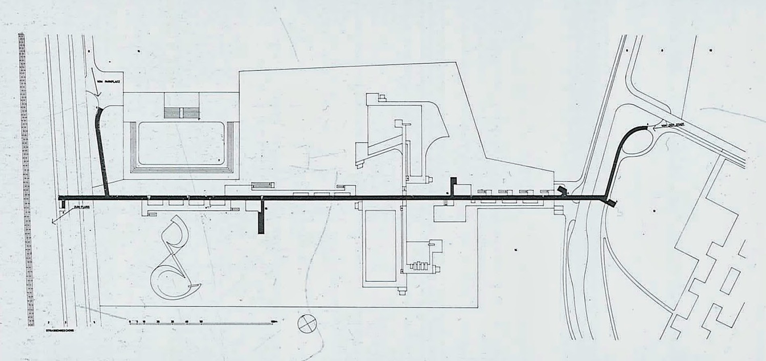
Site plan of the Bellizona Bathhouse.
The project consisted of a two-story linear building. The roof of the building became an elevated promenade 6 meters above ground level, crossing the void of the Ticino Valley. In this way, circulation within the building responded to a clear understanding of the urban structure, allowing the building to be reached fluidly from the city center. As Galfetti himself explained, the access path to the bathhouse was materialized through a concrete structure that constructed the landscape and organized the territory (Galfetti, 1978). Thus, all the functional aspects of the project were resolved by subordinating them to a territorial vision, since Galfetti’s intention was to generate a structure that gave this peri-urban area the character of an open city, projected into the landscape, ready to receive new activities. The building was thus adapted to the local environment, including both the needs of its users and a clear logic of territorial development.
Galfetti sought to achieve an architectural esthetic that integrated the building with the surrounding landscape and the city of Bellinzona. He stated that landscape and architecture must work in harmony, complementing one another, not imposing themselves on one another (Galfetti, 1978). This approach reflects a design philosophy that went beyond the purely esthetic, and made the integration of the building into the urban and territorial fabric of Bellinzona a core objective. Galfetti’s architectural intervention can be understood as a successful mediation between built form and context. The project forges a meaningful relationship between the new public space of the bathhouse and its surroundings—the flat valley floor, the undulating Ticino landscape, the urban fabric of Bellinzona, and the sky. Through its spatial organization and strategic use of terraces, the design fosters dialog with the peri-urban environment, positioning the bathhouse not as a disruptive insertion but as a coherent extension of the public realm (Figure 2). Moreover, the deliberate selection of materials and architectural composition enhances both the infrastructural performance of the site and the immersive quality of the spatial experience.
Figure 2
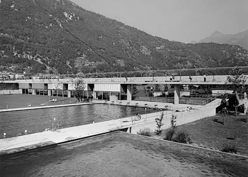
View of the Bellizona Bathhouse.
The bathhouse is an emblematic example of how architecture can impact the urban and territorial organization of a city. Galfetti approached this project with a vision that went beyond the construction of a building intended for recreational and sports activities. This architectural intervention organized the peri-urban space, playing a key role in connecting the urban center with the Ticino River and the road along the Saleggi channel, which until then had been located on the outskirts. In this way, the design conceived by Galfetti became a vital connection between the city, the river and the channel, facilitating connection of Bellinzona with the surrounding natural areas.
3.2 Case study 2: ZKM (Germany)
The ZKM (German: Zentrum für Kunst und Medien), also known as Bauhaus Electronica, was founded in 1989 as a futuristic institution. Today, it includes among other auxiliary spaces a multimedia art museum, a museum of contemporary art, research and production facilities for music, video, and virtual reality, a multimedia theater, a lecture hall, and a media library. In its first year, the ZKM held a design competition for a new building. The winning entry was drawn up by the Dutch architect Rem Koolhaas of OMA. The design proposed a laboratory open to the public, a massive apparatus for investigating the connection between art and technology. This project was to be situated on a narrow strip of land on the outskirts of the baroque city of Karlsruhe, adjacent to the site of a proposed high-speed rail station, between the train tracks and the looping slipways of the peripheral highway, overlooking the entrance and exit ramps of the bus station. Construction of the so-called Koolhaas-Cube was abandoned in 1992. However, the design did inform the work of Philipp Jakob Manz, the architect who was placed in charge of refurbishing part of a ruined weapons and munitions factory in the same area, which became the home of ZKM in 1997.
The original OMA design concentrated ZKMs entire range of activities in a single container measuring 43 × 43 × 58 m (Figure 3). This building sought to address fragmentation and dispersion of programs and objects by bringing them together into a single building-mass (Koolhaas et al., 1995). Inside this container, different elements were stacked: music and film studios, then video and computer labs, multimedia theater, a multimedia museum, library and lecture hall, contemporary art museum, restaurant, and outdoor terrace. This sequence corresponded to a transition from production to research to exhibition; from the artificial to the natural; from the private to the public. This organization offered Koolhaas the opportunity to explore the skyscraper typology that had captivated him during his time in Manhattan, transforming a vertical stratification of programs into a tribute to the culture of metropolitan urban congestion (Koolhaas, 2014). The building was in fact intended to be a superstructure with a ‘hybrid condition’, in which the specificity of uses mattered little (OMA Website, 2025). To the south, an empty space running the entire height of the building was to be included to allow sets, electronic devices, projectors, containers, and capsules to be moved up and down or locked in place to create new layouts on specific floors. The design sought to generate density, exploit proximity, provoke tension, maximize friction, organize intermediate points, promote filtering, and foster the identity of the city and the region.
Figure 3
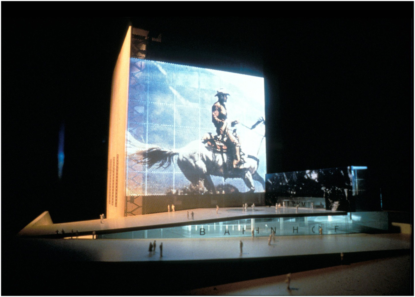
Model of the ZKM.
From a distance, the outline of the planned construction was reminiscent of a large power plant, a stranded machine or artifact, in a way reminiscent of the ironic aircraft carrier in the Transformations series by Hans Hollein with his. Through its height, the building aimed to address both the center and the peri-urban area of the city, proclaiming its relationship with both of these urban environments. Koolhaas intended the site, on a railway embankment, to be directly connected to the station’s circulation, and thus form a new two-sided architectural typology: for the city, it was a Station-Museum; for the peri-urban area, a Museum-Station. The OMA design sought to adopt a multi-scalar character by way of its strategic position between the city center and peri-urban periphery, and its proximity to major communication hubs on a regional and continental scale. In this way, the project looked to structure the relationship between the urban center and peri-urban areas, signify the peri-urban landscape and provide the territory with iconic cultural infrastructure.
In the OMA design, massive black concrete walls define the east and west sides of the structure, between which stretch seven six-meter-high Vierendeel beams. This massive structure alternates between floors completely free of pillars and floors where the uprights of the Vierendeel beams are perceived as pillars. This design technique was intended to allow for the free placement of elements related to different uses (Figure 4).
Figure 4
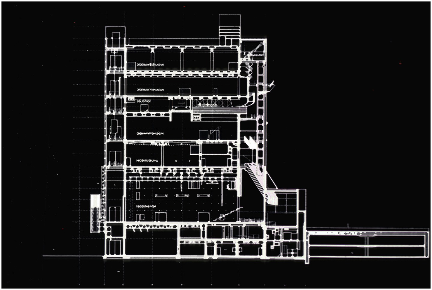
Section of the ZKM.
The city façade was envisioned as housing a system of elevators, escalators, ramps, and balconies ascending in a continuous movement. On the eastern side, the façade was to serve as an electronic billboard: the center’s activities were to be projected in real time, alternating with commercial messages, rail network bulletins, and television programs. At the foot of the screen, a ramp was to lead directly to the entrance of the ZKM. Beneath the ramp, a new lobby would serve as an urban interchange, from which a passageway would run under the tracks to connect the north and south entrances.
As stated by Koolhaas, ‘the ZKM is a manifesto for a new type of deep/large building, where the fragmented elements of recent architecture can be reassembled into an organization that depends neither on compositional nor esthetic criteria: a technologically sophisticated domain where complexity and freedom can be simultaneously pursued’ (Koolhaas et al., 1995).
3.3 Case study 3: Easier Taken Slow (Albania)
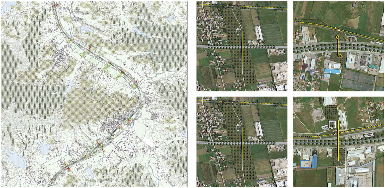
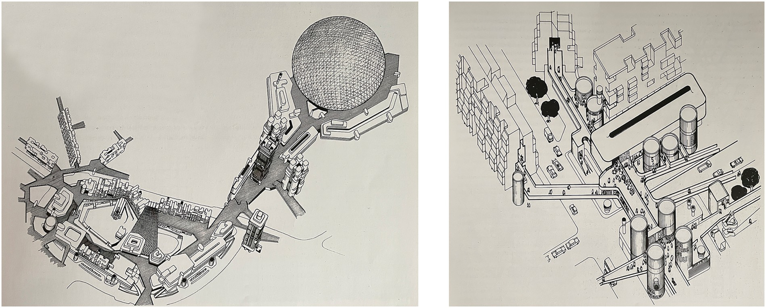
The architectural firm Dogma proposed Easier Taken Slow in 2014. This territorial-scale project sought to reconceptualise the road and highway system connecting the Albanian cities of Tirana and Durrës. For Dogma, this land transport system represented an opportunity to structure and give meaning to the surrounding peri-urban landscapes.
The Tirana-Durrës transport corridor was conceived of as being transit infrastructure exclusively, intended to facilitate high-speed mobility and industrial development in its vicinity. However, in line with contemporary theories on urbanism and peripheries (Secchi, 2000), Dogma proposed reconceptualizing the corridor as civic infrastructure, in which the landscape, pre-existing settlements, railways, and road infrastructure would be articulated as active components of a coherent urban system (Figure 5).
Figure 5
Site plans of the Easier Taken Slow project.
Following the principles of sustainable urban intervention (Gehl, 2010), Dogma’s proposal was based on a set of minimal, strategic, and affordable actions designed to be implemented in successive phases. These actions sought to provide a tangible structure to the surrounding territory, generating functional interconnectivity between different urban elements. In this sense, the backbone of the intervention was located in the section between the settlements of Borakë and Bërzhull, where a reconsideration of the corridor was proposed. This involved not only the juxtaposition of a highway and a group of buildings, but an intermodal network of existing and potential mobility infrastructure (Banham, 2020).
Consistent with urban models that promote connectivity at different scales (Lynch, 1960; Jacobs, 1992), Dogma proposed parallel secondary roads located north and south of the main axis. These secondary roads would facilitate both local mobility and access to the industrial and logistics sites located along the highway, without compromising the functionality of the main artery. This approach was consistent with urban design strategies that seek to improve transportation efficiency and minimize the negative impacts of road fragmentation on the urban structure (Marshall, 2004; Bertolini, 2012).
Instead of an unbroken series of industrial estates along the highway route (as the land-use map suggested), the architects proposed preserving large portions of land free of any construction at regular intervals of approximately 750 meters. That is, in addition to defining buildable areas, the project also defined non-buildable zones, seeking to foster the integration of the landscape with the urban environment. In these areas, Dogma proposed planting olive trees, not only as an ecological and landscaping strategy, but also as reference to territorial and cultural identity.
The project also contemplated the installation of pedestrian and bicycle bridges along the corridor. Their implementation would ensure safe connections between both sides of the highway and facilitate sustainable mobility and the use of alternative transport, in line with contemporary urban planning and active mobility strategies (Newman and Kenworthy, 1999). These bridges, based on modular steel construction, could be installed progressively and efficiently. The project also proposed a variety of collective infrastructures along the corridor, linked to the pedestrian bridges, including civic centers, schools, kindergartens, libraries, bazaars, and intermodal train or tram stations (Figure 6). These were designed taking into account local conditions and responded to a diversified programmatic layout. Some of these facilities adopted an introverted circular typology, suitable even for locations in close proximity to the highway. In particular, the bazaar was conceived as a multifunctional covered structure able to house both commercial and community activities.
Figure 6
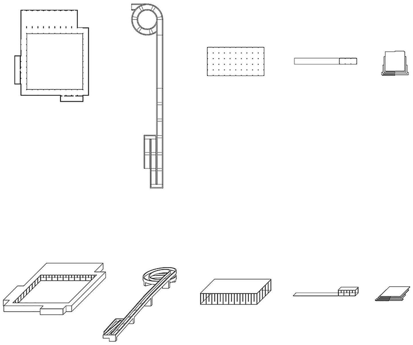
Architectural elements used in the Easier Taken Slow project.
Finally, a key element of the intervention was the creation of viewing points, brick platforms that established a visual and symbolic connection between the Durana corridor and the natural slopes that make up the area. These spaces not only enhanced the experience of the landscape but also reinforced the corridor’s identity as an integrated peri-urban system.
3.4 Case study 4: Communal Villa (undetermined location)
Communal Villa is a project initiated by Dogma in 2015 and still under development, conceived as a collective residence combined with workspaces for artists and creative practitioners. The building, or rather the prototype design, consists of an almost perfect cube that integrates artists’ individual work spaces with their communal life. In the design, based on a grid layout, a series of individual dwellings are arranged on the building’s four facades. These include accommodation and work areas for each artist (Figure 7). In the central area, an open space occupies the entire height of the building. It reveals the continuity of the grid on all floors, acts as a space to host community and recreational activities, and seeks to encourage relationships between the inhabitants and the building’s other users.
Figure 7
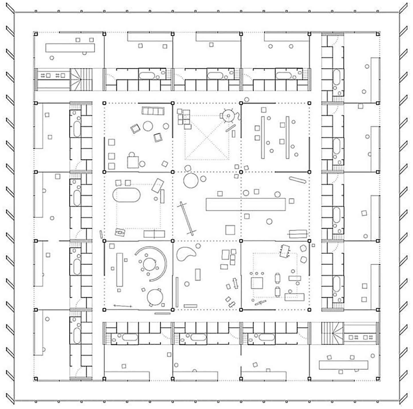
Plan of the Communal Villa.
Much like Palladio’s more abstract and theoretical villas, the project lacks any orientation, opening equally to all facades. Through this project, Pier Vittorio Aureli continues his investigation into the power of simple forms to express a compelling leftist discourse that challenges conventional forms of habitation. The interiors of the studios/homes are also subject to the same radicalism. The living units bring together all the functional spaces including the bathroom, bedroom, and kitchen. They also offer a large double-height area in which each artist can develop their personal work. Design decisions are minimized as far as possible and the project focuses on generating different individual or collective environments through the structuring of the interior space.
The project is therefore a hybrid artifact, presented as a system, that is, as a model or a prototype. It is not intended for a specific place; in fact, Dogma’s proposal places it in various locations, which are always peri-urban (Figure 8). In these areas, the centrality of the city has disappeared, infrastructure creates a void while at the same time representing a node, and nature merges with the urban. Dogma’s Communal Villa proposal is, on the one hand, the result of an abstract process of research and experimentation. On the other, it is specific to peri-urban areas, which share certain common characteristics despite being distributed globally.
Figure 8
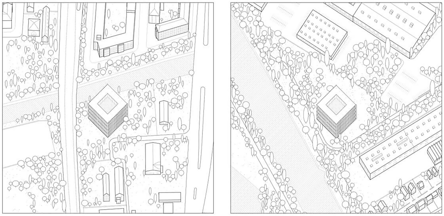
Axonometric view of the possible locations of the Communal Villa.
The formal, material, and conceptual austerity of architecture plays an ideological role in this project by Dogma, by granting prominence to the building’s capacity to provoke a social transformation in terms of encounter, relationships, diversity, and the cohesion of an unstructured area. As Aureli himself states, ‘the perversion of asceticism is not simply its translation as ‘sausterity’ but also its branding as image, which in times of austerity has become not only fashionable but also ideological. And yet it is precisely because economic austerity is a subjective economy, aiming to manipulate the subject’s moral and ethical sphere, that asceticism offers also the possibility to emancipate subjectivity from such manipulation’ (Aureli, 2013).
3.5 Case study 5: Charleroi Convention Centre (Belgium)
The Charleroi Convention Centre was designed by architect Joseph André in 1948 and hosted exhibition and leisure activities for over half a century. The Convention Centre became a symbol of the prosperity of Wallonia, an area which had a major coal-fuelled industrial sector. The grandiose 66,000-square-meter building was organized into two large, three-story volumes containing exhibition halls, structured around a majestic central foyer. It is located between the edge of the historic city and the region’s main land transport infrastructure, in the peri-urban area between the urban core and the outskirts of Charleroi (Figure 9).
Figure 9
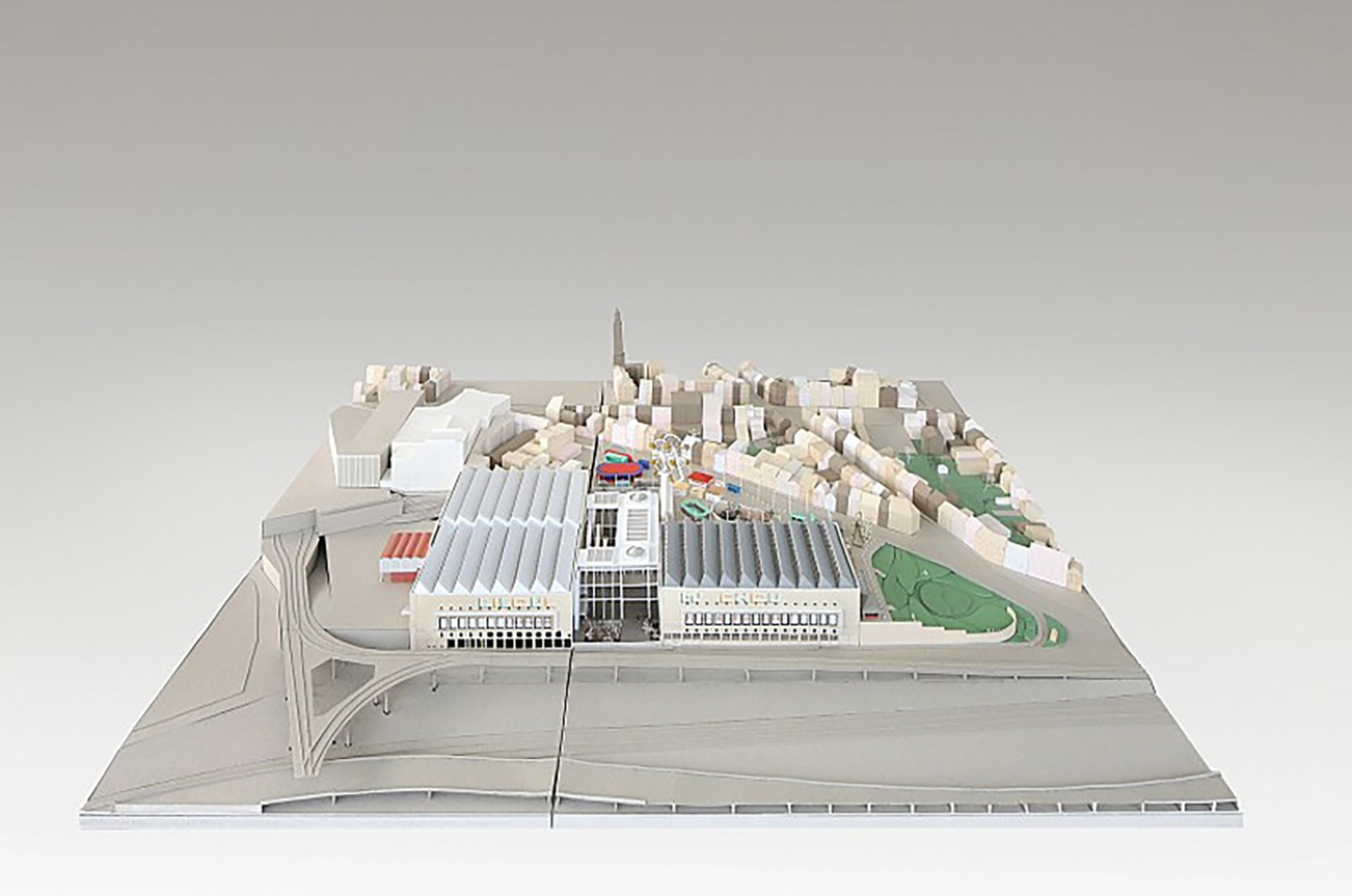
Model of the Charleroi Convention Centre.
In 2015, an international competition was held for a major reconstruction of the Convention Centre. The winning bid was submitted by the Belgian architectural firm AgwA. Interestingly, the bid ignored a significant part of the competition brief. Instead of replacing the central lobby with a new construction as suggested, the architects involved opted to remove the existing lobby’s exterior walls, leaving the structure bare and creating a series of covered urban terraces (Figure 10). In this way, the building generated a new public space in its central area that connected the peripheral neighborhoods with the city’s urban core and, through a number of covered public spaces, bridged the significant difference in elevation between the center and the outskirts. This new public space not only became an anteroom for the new, smaller, Convention Centre, but also managed to restructure the urban fabric and connect with the territorial scale. Through this intervention, the building not only connected the city center and the outskirts, but also became a landmark on a territorial scale, taking advantage of its strategic position with respect to the major transport infrastructure of Wallonia.
Figure 10
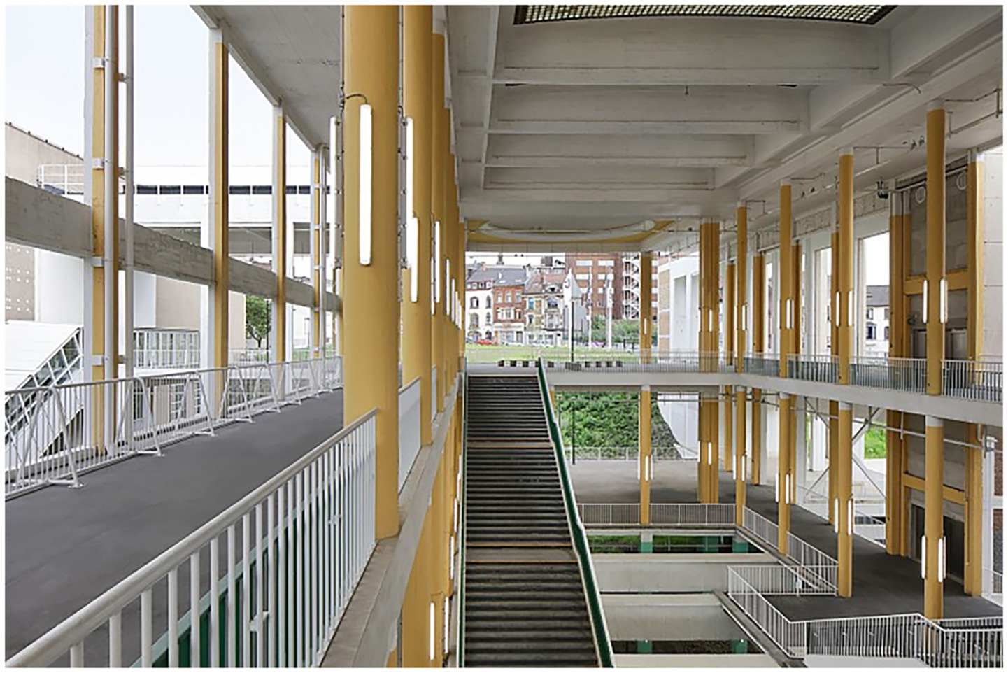
View of the central building of the Charleroi Convention Centre converted into a public space.
In an additional departure from the brief, instead of creating three new levels of underground parking, AgwA proposed locating all parking on three floors of the southern building. By using only the northern volume to accommodate the new events space, the project minimized the need for artificial climate control, which drastically reduced both the construction budget and ongoing energy costs. Due to its large size and spatial neutrality, the Charleroi Convention Centre is today a flexible urban space adaptable to a diversity of uses at an urban and territorial scale.
4 Discussion
The architectural projects analysed in this paper understand peri-urban areas as complex adaptive systems, open to external influences and composed by temporal structures and relationships that co-evolve over time. This creates a myriad of opportunities for spatial innovation. Architectural interventions represent a means to embrace the fragmented and incomplete nature of the peri-urban landscape, and the opportunity that they offer to explore a new spatiality that generates new ways of inhabiting the territory.
The case studies that we have analysed bear a direct relationship to many of the utopian architectural proposals that emerged throughout the 20th century. Examples of these include Soviet social condensers, Japanese megastructures, and Constant’s Terrain Vagues (Banham, 2020). All these sought to transcend their immediate programmatic function and become artifacts able to exert their influence over a wider territory. These architectures not only established a relationship with their surrounding environment, but also straddled different territorial, urban, and architectural scales. A shared concept is that the building transcends its physical limits and integrates into a network of networks. In this way, it integrates into its surroundings and produces infrastructural architecture. The term infrastructure, in this context, is used in accordance with to Marxist theory. Infrastructure is not simply the material environment, but the material basis of society. As such, it plays a determining role in social structures, development, and social change. Infrastructural architecture is therefore understood as being capable of restructuring the hybrid and multiple realms of the peri-urban landscape (Rodriguez-Ramírez, 2015).
Henri Lefebvre makes the case that ‘infrastructure not only sustains the functioning of the city, but also shapes social relations and urban space’ (Lefebvre, 2013). This idea of infrastructural architecture is evident in projects such as Alison and Peter Smithson’s Berlin Hauptstadt competition entry (1957), which rejected the functionalist planning of the Athens Charter to focus on human association (Figure 11). Their large, low-rise, high-density “mat-building” features an abstract, flexible structure, designed to foster mobility, interconnected flows, and community life. This approach is also reflected in their project for the University of Sheffield (1953), in which the same architects introduced the ‘elevated street’ as a space for social communication that extended the boundaries of the building and connected it to the city.
Figure 11
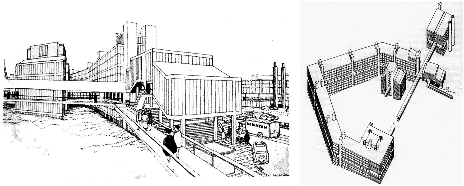
Drawings of the Berlin Haupstadt project.
These infrastructural architectures embrace the ecosystemic, socio-demographic, and institutional complexity of peri-urban areas and have the capacity to interact with the pre-existing local structures, embracing their logic while also bringing new spaces into being. Infrastructural architecture, by intervening in hybrid peri-urban environments, takes on a key restructuring capacity in the configuration of “third spaces.” This is apparent in the way that the peri-urban architectures we have analysed interact with transport infrastructures and organizational systems.
A cross-comparison of the five cases studies reveals some common strategies, and a shared logic for this type of architecture defined by its peri-urban location.
The first common characteristic to highlight is the multi-scalar nature of these projects, which is a response to the multiple scales present in the peri-urban space. Both the Bellinzona Bathhouse and the Easier Taken Slow project engage with regional and peri-urban scales, and it is precisely this multiscalar responsiveness that enables their transformation into infrastructural forms of architecture. In the case of the ZKM design, the building mediates between urban and regional flows via the newly integrated station, establishing itself as a prominent urban landmark that visually links the peri-urban landscape with the baroque fabric of Karlsruhe. In the renovation of the Charleroi Convention Centre, the radical openness generated through the literal removal of walls rearticulates circulation in the district, the city, and the territory itself.
As the Swiss architect Mario Botta points out, ‘architecture is not only the creation of enclosed spaces, but the articulation of relationships between the different elements of a territory’ (Botta, 1990). In this sense, the case of Bellinzona Bathhouse is a reference point within the city, a landmark distinguished not only by its architectural form, but also by its ability to reconfigure the territory. The Bathhouse integrates into the existing urban fabric, promotes a fluid relationship between the historic center and peripheral areas, and becomes a node on a territorial scale. In a similar way, the ZKM and the Charleroi Convention Centre are not simply isolated buildings, but rather infrastructural architectures that seek to generate points of confluence between the city and the main transport flows. Both are aspired to be key elements in the sub-urban and territorial structure.
A second common characteristic of all five projects is their commitment to connectivity, and their ability to reconnect dispersed and diverse fragments of the peri-urban landscape. In this sense, the Bellinzona Bathhouse can be understood as a connector between the urban center and the river. Swimming pools and sports facilities are integrated into the space of the city. This radical connectivity can also be observed in the renovation of the Charleroi Convention Centre. Connection is at the heart of this project, in both plan and in section, as it bridges the difference in elevation between the urban center and the peri-urban area, while articulating an interior street equipped with covered public spaces linked to the building’s amenities. Similarly, the ZKM and Easier Taken Slow projects operate more as connective infrastructure than as conventional buildings. These unrealized projects prioritize the facilitation of citizen movement and promote spatial continuity by allowing space to flow through the built form. A precedent for these proposals can be found in some of Archigram’s utopian projects (Figure 12). The idea of hyper-connectivity is also apparent in projects such as the Fulham Studio, an urban project that conceived of the neighborhood as a small city within London. Inspired by the University of Sheffield and the Berlin Hauptstadt, this proposal merged mobility, housing, and commerce into an interconnected structure. Furthermore, it integrated mixed uses, combining light manufacturing with tertiary sectors to reduce travel and foster a more dynamic and self-sufficient urban life.
Figure 12
Drawings of the Fullham Study.
Linked to connectivity, we identify a third common characteristic which we could call the urban condenser. All the case study projects have a certain capacity to create a new centrality able to impact the social structure and open up new ways of living. This idea is exemplified in Dogma’s Communal Villa, a project that rethinks traditional dwelling typologies by integrating productive spaces, emerging urban living models, and shared communal areas within a unified architectural system. By increasing spatial density, the project fosters greater social interaction and redefines the relationship between living and working environments. The redesign of the Charleroi Convention Centre project similarly aimed to generate a concentration of activity by strategically condensing pedestrian flows. In this context, users of the convention center merge seamlessly with individuals simply present in public space, either engaged in a specific activity or simply passing through, navigating the transitional zone between the city center and its periphery.
A fourth common strategy is functional indeterminacy or multifunctionality. This reinforces and amplifies the principle of architecture as an urban condenser or new urban centrality. The inclusion of mixed uses within a building complex enhances synergies, diversity, and variety. The structural and spatial system of the Communal Villa, for example, permits multiple functional configurations of different spaces, allowing users to adapt the space to their needs. By offering flexibility and diversity of use, architecture adapted to the peri-urban landscape operates as a container, capable of accommodating endless functional options. In this sense, among the projects that seek to introduce high densities of uses and functional diversity into obsolete peri-urban industrial areas, the ZKM stands out. The planned large volume, which on a territorial scale could be understood as an exercise in urban acupuncture, aimed to offer a reprogrammable structure capable of supporting a wide variety of interchangeable uses.
Seeking to fulfill a role as an infrastructural artifact status is precisely the fifth and final common characteristic of the case studies we have addressed. In fact, this role is a requirement of meeting the other objectives outlined above. All five projects addressed adopt the logic of infrastructure. The structural systems of many of these buildings incorporate engineering solutions commonly associates with road, bridge, and railway infrastructure. The ZKM proposal, Bellinzona Bathhouse, and the Communal Villa all constitute megastructures as defined by Banham (2020). This means that they are transformative, more ambitious and idealistic than constructible, and that their value lies in their ability to open paths and surpass the limits of the architectural object. Along these lines, the concept of megastructure in some ways transcends architecture without fully belonging to urban planning, functioning as a catalyst for new solutions for structuring peri-urban areas.
5 Conclusion: toward a peri-urban architecture
Architecture can represent a dynamic, context-sensitive strategy to address the complexities of peri-urban environments. Peri-urban architecture should be conceived as an infrastructural system capable of engaging with the existing morphological and socio-spatial conditions of the peri-urban fabric. It must incorporate the underlying logic of these territories, recognize the value in ‘third spaces’ —residual, unmanaged spaces — and facilitate the production of alternative spatial scenarios. Within this framework, architecture functions analogously to acupuncture, strategically activating key nodes to catalyze novel modes of inhabitation within peri-urban landscapes. It can thereby generate multi-scalar impacts that range from the neighborhood scale to the broader territorial context.
The characteristics that make these architectures transformative devices for peri-urban areas are: (a) multi-scalarity; (b) hyper-connectivity; (c) urban condensation; (d) programmatic indeterminacy; and (e) their mega-structural or infrastructural nature. These five conditions form a set of architectural strategies for the development of new peri-urban architectures.
The multi-scale hybrid projects located in the peri-urban landscape that we have analysed are artifacts for territorial transformation, operating at an architectural scale while also integrating a comprehensive understanding of the metropolitan and the regional. Their capacity to integrate infrastructure and mobility redefines the relationship between the city and its peri-urban areas, finding in the often poorly configured space of the peri-urban landscape a perfect setting for architectural and urban experimentation.
This paper represents an initial approach to the study of peri-urban architectures. This entails certain methodological limitations. We adopted a general overview of peri-urban contexts, covering a broad temporal framework while also limiting the analysis to five case studies. This preliminary approach does not delve deeply into the key parameters identified —multiscalarity, hyper-connectivity, spatial condensation, programmatic indeterminacy, and a megastructural typology. Instead, it offers a broad reading of the overall phenomenon. Future research could focus on specific contexts, allowing for a more in-depth examination of the peri-urban architectures in the context of their specific location. It would also be useful to expand the number of case studies in order to build a more robust catalog of architectural strategies, or alternatively, to explore one of the selected cases in greater depth by focusing on specific aspects that contribute to the systematization of knowledge on the peri-urban landscape.
Statements
Data availability statement
The raw data supporting the conclusions of this article will be made available by the authors. Requests to access the datasets should be directed to ezekiel.collantes@ehu.eus.
Author contributions
EC: Conceptualization, Data curation, Formal analysis, Funding acquisition, Investigation, Methodology, Project administration, Resources, Software, Supervision, Validation, Visualization, Writing – original draft, Writing – review & editing. IG: Conceptualization, Data curation, Formal analysis, Funding acquisition, Investigation, Methodology, Project administration, Resources, Software, Supervision, Validation, Visualization, Writing – original draft, Writing – review & editing.
Funding
The author(s) declare that no financial support was received for the research and/or publication of this article.
Acknowledgments
The authors would like to express their gratitude to the Department of Architecture, University of the Basque Country.
Conflict of interest
The authors declare that the research was conducted in the absence of any commercial or financial relationships that could be construed as a potential conflict of interest.
Generative AI statement
The authors declare that no Gen AI was used in the creation of this manuscript.
Publisher’s note
All claims expressed in this article are solely those of the authors and do not necessarily represent those of their affiliated organizations, or those of the publisher, the editors and the reviewers. Any product that may be evaluated in this article, or claim that may be made by its manufacturer, is not guaranteed or endorsed by the publisher.
References
1
Agamben G. (2009). What is an apparatus?. Stanford: Stanford University Press.
2
Allen A. (2003). Environmental planning and Management of the Peri-Urban Interface: perspectives on an emerging field. Environ. Urban.15, 135–148. doi: 10.1177/095624780301500103
3
Aureli P. V. (2011). The possibility of an absolute architecture. Cambridge MA: MIT Press.
4
Aureli P. V. (2013). Less is enough: On Architeccture and asceticism: Strelka Press.
5
Banham R. (2020). Megastructure: Urban futures of the recent past. New York: The Monacelli Press.
6
Baxter P. Jack S. (2008). Qualitative case study methodology: study design and implementation for novice researchers. Qual. Rep.13, 544–559. doi: 10.46743/2160-3715/2008.1573
7
Bertolini L. (2012). Integrating mobility and urban development agendas: a manifesto. DisP. Plan. Rev.48, 16–26. doi: 10.1080/02513625.2012.702956
8
Botta M. (1990). Mario Botta: Architecture and design. New York: Rizzoli International Publications.
9
Clément G. (2004). Manifesto of the third landscape: Place of Publication Not Identified: Trans Europe Halles.
10
Galfetti A. (1978). The architecture of Aurelio Galfetti. Zurich: Birkhäuser.
11
Garreau J. (1991). Edge City: Life on the new frontier. New York: Dobleday.
12
Gehl J. (2010). Cities for people. Washington, D.C.: Island Press.
13
Jacobs J. (1992). The death and life of great American cities. 1961. New York: Vintage.
14
Koolhaas R. (1995). The Generic City: Sikkens Foundation.
15
Koolhaas R. (2014). Deirious New York: A retroactive manifesto for Manhattan. New York: Monacelli Press.
16
Koolhaas R. Werlemann H. Sigler J. Mau B. Office for Metropolitan Architecture (1995). S, M, L, XL: Small, Medium, Large, Extra-Large. New York. New York Monacelli Press.
17
Lefebvre H. (2013). La Producción Del Espacio.1974. Madrid: Capitán Swing.
18
Lynch K. (1960). The image of the City, vol. 11. Cambridge, Mass: MIT Press.
19
Marshall S. (2004). Streets and patterns. London: Routledge.
20
Mortoja M. D. Golam T. Y. Mayere S. (2020). What is the most suitable methodological approach to demarcate peri-urban areas? A systematic review of the literature. Land Use Policy95:104601. doi: 10.1016/j.landusepol.2020.104601
21
Muratovski G. (2016). Research for designers: A guide to methods and practice. London: SAGE.
22
Newman P. Kenworthy J. (1999). Sustainability and cities: Overcoming automobile dependence. Washington: Island Press.
23
‘OMA Website’ (2025). Available online at: https://www.oma.com/projects/zentrum-fur-kunst-und-medientechnologie (accessed [February 1, 2025]).
24
Pace L. Mughini Gras J. (2024). The peri-urban landscape. New York: River Publishers.
25
Rauws W. S. de Roo G. (2011). Exploring transitions in the peri-urban area. Plan. Theory Pract.12, 269–284. doi: 10.1080/14649357.2011.581025
26
Ravetz J. Fertner C. Nielsen T. S. (2013). “The dynamics of peri-urbanization” in Peri-urban futures: Scenarios and models for land use change in Europe. eds. NilssonK.PauleitS.BellS.AalbersC.Sick NielsenT. A. (Berlin, Heidelberg: Springer), 13–44.
27
Rodriguez-Ramírez F. (2015). Un Entendimiento Infraestructural Del Proyecto Arquitectónico. Madrid: Universidad Politecnica de Madrid.
28
Sassen S. (2001). The Global City: New York, London, Tokyo. REV-Revised. Princeton: University Press.
29
Secchi B. (2000). Prima Lezione Di Urbanistica. Bari: Laterza.
30
Secchi B. (2002). The emergence of the diffuse city. Diagonal156, 10–12.
31
Sieverts T. (2003). Cities without cities: An interpretation of the Zwischenstadt. London: Routledge.
32
Silva C. (2019). Auckland’s urban sprawl, policy ambiguities and the peri-urbanisation to Pukekohe. Urban Sci.3:1. doi: 10.3390/urbansci3010001
33
Woltjer J. (2014). A global review on Peri-urban development and planning. Jurnal Perencanaan Wilayah Dan Kota25, 1–16. doi: 10.5614%2Fjpwk.2014.25.1.1
Summary
Keywords
peri-urban area, city, territory, hyper-connectivity, programmatic indeterminacy, multi-functionality, megastructure, infrastructural
Citation
Collantes E and García Odiaga I (2025) In between, an artifact: multiscale hybrid architectural projects for the peri-urban landscape. Front. Sustain. Cities 7:1603141. doi: 10.3389/frsc.2025.1603141
Received
01 April 2025
Accepted
16 July 2025
Published
12 August 2025
Volume
7 - 2025
Edited by
Shabtai Isaac, Ben-Gurion University of the Negev, Israel
Reviewed by
Yasmein Okour, Jordan University of Science and Technology, Jordan
Francesco Camilli, Norwegian University of Science and Technology, Norway
Updates
Copyright
© 2025 Collantes and García Odiaga.
This is an open-access article distributed under the terms of the Creative Commons Attribution License (CC BY). The use, distribution or reproduction in other forums is permitted, provided the original author(s) and the copyright owner(s) are credited and that the original publication in this journal is cited, in accordance with accepted academic practice. No use, distribution or reproduction is permitted which does not comply with these terms.
*Correspondence: Iñigo García Odiaga, i.garcia@ehu.eus
Disclaimer
All claims expressed in this article are solely those of the authors and do not necessarily represent those of their affiliated organizations, or those of the publisher, the editors and the reviewers. Any product that may be evaluated in this article or claim that may be made by its manufacturer is not guaranteed or endorsed by the publisher.