PT
philemon tsele
University of Pretoria
Pretoria, South Africa
3,853
Total downloads
22k
Total views and downloads
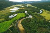
Biodiversity monitoring forms a critical aspect of managing and planning protected areas, necessitating precise assessments of biophysical variables that indicate ecological health. Vegetation biophysical variables like leaf area index (LAI), chlorophyll concentration, Fraction of Absorbed Photosynthetically Active Radiation (fAPAR) and fractional vegetation cover (FVC), stand out as essential biodiversity variables (EBVs) in these settings. Remote sensing emerges as a potent alternative for monitoring these EBVs, allowing for the extensive and non-intrusive gathering of ecological data. Despite the widespread application of methods ranging from parametric and non-parametric regression to physically-based model inversions and hybrid approaches, the accurate retrieval of these variables in varied protected landscapes remains a complex challenge. The performance of these techniques, particularly in diverse environments like mountainous terrains with variable land covers and slopes, demands a thorough evaluation and integration to enhance accuracy.
This Research Topic aims to elevate the accuracy and applicability of remote sensing methods in extracting vegetation biophysical variables across diverse protected areas. It seeks to address the inconsistencies in current methodologies by comparing and integrating different retrieval models. The goal is to refine these methods for better accuracy in heterogeneous natural environments, enhancing the reliability of remote sensing for environmental monitoring and conservation efforts. Integrating these methods with ground-based observations and citizen science data is important for ensuring reliable and scalable models. Furthermore, remote sensing plays a critical role in monitoring temporal changes, including seasonal and long-term biodiversity trends, and understanding biodiversity responses to climate change. Emerging technologies, such as cloud-based processing, artificial intelligence, and new sensors, present transformative opportunities for biodiversity monitoring.
To gather further insights in the established boundaries of remote sensing applications in biodiversity monitoring, we welcome articles addressing, but not limited to, the following themes:
• Multi-spectral and hyperspectral remote sensing
• SAR and Lidar remote sensing
• Sensors integration, including novel sensors such as PACE, GEDI, SWOT, and PRISMA
• Analysis across multiple scales
• Development and testing of parametric and non-parametric retrieval methods
• Advancements in physical and hybrid retrieval models
• Algorithm development, including the application of artificial intelligence and big data analytics
• Theoretical model validation
• Regional and global product verification
• Applications in natural (terrestrial and aquatic) and agricultural environments
• Temporal monitoring of biodiversity trends and responses to climate change
• Links to actionable conservation strategies and policy making
Keywords: biodiversity, vegetation, remote sensing, biochemical, area management, protected areas
Important note: All contributions to this Research Topic must be within the scope of the section and journal to which they are submitted, as defined in their mission statements. Frontiers reserves the right to guide an out-of-scope manuscript to a more suitable section or journal at any stage of peer review.
