 Wendy K. Stovall1*
 Jessica L. Ball2
 Elizabeth G. Westby3
 Michael P. Poland3
 Aleeza Wilkins4
 Katherine M. Mulliken5
- 1U.S. Geological Survey, Volcano Science Center, Vancouver, WA, United States
- 2U.S. Geological Survey, California Volcano Observatory, Moffett Field, CA, United States
- 3U.S. Geological Survey, Cascades Volcano Observatory, Vancouver, WA, United States
- 4U.S. Geological Survey, Natural Hazards Mission Area, Reston, VA, United States
- 5Research Corporation of the University of Hawaii, Hawaiian Volcano Observatory, Hilo, HI, United States
The USGS Volcano Science Center has a long history of science and crisis communication about volcanoes and their eruptions. Centered mainly on websites, email notifications, traditional media, and in-person interaction in the past, our toolkit has expanded in the last decade to include social media channels. This medium has allowed us to communicate with both long-standing and new audiences in new ways. In the process, social media communication has further developed trust in USGS researchers. In particular, the nearly 4-month-long 2018 eruption of Kīlauea volcano in the State of Hawaii necessitated the rapid development of a communication strategy that more deeply incorporated web and social media (Facebook and Twitter) channels to share critical eruption information. This was the first major volcanic eruption response where the USGS used official social media accounts as a significant form of public communication and outreach. These timely and conversive interactions furthered engagement with residents and reinforced the USGS as an authoritative and approachable voice on the eruption with U.S. and international audiences. In many cases, USGS Volcanoes' social media channels were also sampled directly by media outlets looking to provide current information, particularly by local reporters and citizen journalists. This helped disseminate scientific information directly to those who needed it and removed pressure from observatory scientists to respond to media requests. In short, the conversational tone and engaged and inquisitive online audience allowed the USGS Volcanoes' social media channels to act as a virtual community meeting, which nurtured a nearly continuous educational environment for both directly affected and distant members of the public. We present the history and details of this strategy here in hopes that it will benefit volcano observatories and other official agencies and crisis communicators.
1. Introduction
Within the Federal government, the U.S. Geological Survey (USGS) Volcano Hazards Program is responsible for reporting changes in volcanic behavior in the United States to authorities and the public to minimize losses from a volcanic event (Stovall et al., 2016). The five USGS volcano observatories accomplish this goal by monitoring volcanoes and providing critical alerts, notifications, and situational awareness to mitigate the impacts of volcano hazards. USGS volcano observatories employ a multi-pronged approach that includes a suite of communication products and channels. Social media was an important medium through which USGS shared official information during the 2018 eruption of Kīlauea volcano in the State of Hawaii (Figure 1).
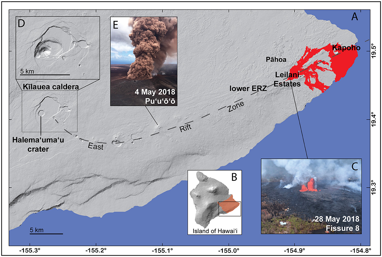
Figure 1. Digital elevation model of Kīlauea volcano prior to the 2018 eruption (A). Kīlauea, located on the Island of Hawaii (B), is the state's most active volcano and was the site of two eruptions in 2018. Lava flows (red area on the right side of A) erupted through neighborhoods (C) and added new land to the island's shoreline. Fissure 8 (C) was the primary source of destructive lava flows that originated in Leilani Estates and eventually reached Kapoho. A total of 612 residences were losta in the Puna district (orange shaded area in B) during the eruptions. Halema‘uma‘u crater floor within Kīlauea caldera collapsed by about 500 m during the 2018 eruption. The post-caldera-collapse digital elevation model (inset D) is based on airborne lidar surveys flown in 2019 (Mosbrucker et al., 2020). On May 4, 2018, 12:44 p.m. HST, a column of robust, reddish-brown ash issued from Pu‘u‘o‘o (E) after a magnitude 6.9 earthquake beneath the south flank (Neal et al., 2019). Pu‘u‘o‘o had been the primary eruption center on Kīlauea for 35 years prior to the changes in 2018, USGS photographs. ahttps://recovery.hawaiicounty.gov/resources/2018-eruption.
The communication of natural hazards information can positively or negatively impact people's lives, livelihoods, and mental health, depending on the quality of the information and what is conveyed. To be effective, it is paramount that official messages (such as those from volcano observatories) be seen and trusted as authoritative sources of scientific information (Petty and Wegener, 1998). Trust is built by forming relationships, being a present, active part of a community, and exhibiting expertise and transparency in communicating hazards (Covello, 2010). Reliable scientific communication also reflects benevolence, openness, competence, and integrity (Besley et al., 2021).
But how can an institution like a volcano observatory build and maintain trust? Volcano observatories are made up of people, often from the same community as the one they serve. Observatory staff learn about community concerns and gain greater empathy by participating in community events, answering questions, and holding conversations with community members. Benevolence is conveyed with empathic communication of safety and hazard information. The same community engagement fosters openness because it shows the willingness of observatory staff to listen. Scientists are generally seen as experts in a specific subject matter (Fiske and Dupree, 2014), and providing consistent information within that area of expertise promotes perceived competency. For example, the level of expertise of the USGS Hawaiian Volcano Observatory (HVO), which is closely integrated with the communities it serves, was ranked highly by a sampling of Island of Hawaii residents based on a study of their communication of eruption information in 2018 (Goldman et al., 2023). By fostering trust before a volcanic crisis occurs, volcano observatories can be more effective and considered a reliable and credible source of information in times of increased hazard (Lowenstern et al., 2022).
Trust can be built in a virtual setting as well. When government agencies actively share information, especially via social media and accessible websites, citizens are more informed about current events and policies, which increases their perception of transparency and trust in government (Song and Lee, 2015). The nature of social media is just that—social—and online spaces can be fostered to feel like communities. First-person storytelling promotes authenticity (Saffran et al., 2020), and participation in continued dialog with social media users enhances this virtual community's willingness to engage with government agencies on social media (Chen et al., 2020). In all cases, trust is more easily achieved when communicating in a conversational style that matches the social media channel upon which content is served (McBride, 2018; McBride et al., 2020).
Sennert et al. (2018) stated that volcano observatories should use social media in addition to more traditional methods to deliver authoritative information and remain in constant contact with the diverse communities that care about and need volcano hazards information. Volcano observatories and those managing related social media accounts must display the same traits of benevolence, empathy, and engagement as shown in in-person communities but in a virtual setting. These traits can be displayed by engaging with followers, answering questions, and conversing with commenters. The USGS Volcanoes social media accounts on Facebook and Twitter upheld the advice of Sennert et al. (2018) and operated as a virtual community meeting during the 2018 eruption of Kīlauea.
In this manuscript, we describe the communication methods used by the USGS Volcanoes' social media team, and we explore the effectiveness of those methods. We also summarize the advantages and pitfalls of our approach as insights for other agencies involved in disaster response. However, our “lessons learned” are by no means applicable only to government agencies or volcanic eruptions; we hope that our strategy for building a trusted communication platform can apply to the broader community of emergency and disaster responders and science agencies.
2. History of USGS volcano-related communication
The USGS has a long history of communicating information about volcanoes in both calm times and during crises. When it was established in 1912, HVO published a series of bulletins and special reports describing volcanic activity in Hawaii (Bevens et al., 1988). By 1980, when Mount St. Helens erupted, telephone, fax, radio, television, and newspaper were the primary means of delivering information about volcanic unrest to stakeholders and the public. Since then, communication channels have evolved to include, in addition to these portals, automated email alerts, webpage postings (Neal et al., 2005; Driedger et al., 2008; Frenzen and Matarrese, 2008), and social media.
The USGS Volcano Science Center1 (VSC) is the umbrella under which all five United States volcano observatories operate to monitor volcanic activity and communicate about volcanic hazards within specific geographic areas. The Alaska Volcano Observatory (AVO) is a joint program of the U.S. Geological Survey (USGS), the Geophysical Institute of the University of Alaska Fairbanks (UAFGI), and the State of Alaska Division of Geological and Geophysical Surveys (ADGGS). AVO monitors volcanoes in Alaska and the Commonwealth of the Northern Mariana Islands. The Cascades Volcano Observatory (CVO) monitors volcanoes in Washington, Oregon, and Idaho. The California Volcano Observatory (CalVO) is responsible for California and Nevada. Yellowstone Volcano Observatory (YVO), a consortium of multiple State, Federal, and academic partners, covers Yellowstone and distributed volcanic systems in the four-corners states of Utah, Colorado, Arizona, and New Mexico. The HVO monitors all the volcanoes in the State of Hawaii and American Samoa.
Technology and methods used to monitor volcanoes are relatively uniform across all observatories. Similarly, communication tools and general strategies can be shared; however, each observatory also liaises with constituents within their designated regions, requiring some degree of individualized communication to reflect differences in culture, volcano types, and hazards. Scientists-in-Charge and communication professionals at the observatories develop relationships with regional government officials and the communities they serve. Observatory staff prepare regional eruption response coordination plans and conduct outreach to communities. This outreach now includes a suite of digital communication tools, such as websites, social media, and push alert notifications. Together, these tools broaden the reach of observatory communication.
In 2018, dramatic changes to the eruptions of Kīlauea volcano on the Island of Hawaii (Figure 1) tested the USGS's capacity to provide timely volcanic crisis information through modern communication channels. The USGS VSC's social media accounts (referred to as USGS Volcanoes in this publication) became a pivotal part of how local, national, and international audiences could see eruption imagery, learn about eruptive events, and have questions answered.
2.1. Social media and USGS volcano observatories
In 2007, the USGS set up social media accounts that spanned the breadth of USGS science. A Facebook page and podcast series (USGS CoreCast) greatly expanded the ability to push information to a broad audience. As social media gained popularity worldwide, a USGS-wide Twitter account was launched in 2009. Throughout the early 2010s, the number of people using social media grew dramatically (Auxier and Anderson, 2021). Facebook gained about one billion users in the first 5 years of that decade (Ortiz-Ospina, 2019). Followership of USGS science on social media also increased, highlighting the reach of such platforms.
A qualitative review of early USGS social media content shows that the topic of volcanoes was consistently among the most popular on the USGS channels. In 2011, a representative from the VSC began posting content and answering volcano-related questions on the USGS Facebook account, which was the most prolific of all the USGS-wide social media platforms. Between 2011 and 2014, volcano-related posts consistently rose to the top of content analytics for the USGS. Scientists invested in communication at volcano observatories and interested citizens often requested a separate USGS channel dedicated to volcanoes. The tipping point occurred during the Pāhoa lava flow crisis in Hawai‘i (see Section 2.4) when lava flows threatened communities. As a result, the USGS Volcanoes' Facebook page (@USGSVolcanoes) was launched in January 2015, with two USGS staff acting as content managers.
At the behest of followers and staff who preferred Twitter over Facebook, USGS Volcanoes established a Twitter account in August 2016 (@USGSVolcanoes). The short character count opened the door for less formal, more succinct, and creative dialogue with volcano-interested followers via Tweets and strings of replies. The audience and reach of USGS volcano-related content grew with the addition of the Twitter account. Two additional USGS staff members began contributing content to social media in August 2017.
Due to the picturesque nature of volcanoes and volcanic eruptions, it was evident that Instagram (a photography-based platform) was also an opportunity to extend the reach of volcano-related social media. Discussions began in early 2018 about expanding to the platform, but an account had not been opened by May 2018, when the Kīlauea eruption began. Although an Instagram account might have been an impactful educational tool, staff time was limited, and the platform launch was delayed until June 2019.
USGS Volcanoes' social media accounts currently feature content related to all U.S. volcanoes, but predominantly feature science about CVO, CalVO, YVO, and HVO. AVO maintains its own social media channels, and USGS Volcanoes' social media accounts share its content.
2.2. Social media strategy in calm
The primary goals for the USGS Volcanoes' social media presence are to inform and educate affected communities about volcano hazards, provide situational awareness in times of crisis, and engage a broad audience in the science of volcanology. The general strategy to achieve these aims is simple:
• Post photo and video content 5 days per week (Monday–Friday). Ensure social media content is available on USGS or affiliate (and linked) websites.
• Generate automated postings of formal USGS volcano alert notifications (Gardner and Guffanti, 2006) and status changes with an Application Programming Interface (API).
• Consider each post a conversation starter; check posts multiple times daily for comments and answer all questions.
a. Respond to comments briefly, with a genuine, helpful tone.
b. Provide follow-up resources that point to additional information.
• Counter mis- and dis-information with non-combative, science-based statements.
• Maintain a quasi-regular schedule of topical posts based on when the U.S. volcano observatories publish informational products (e.g., weekly updates or articles).
As of mid-2022, four USGS Volcano Science Center (VSC) staff develop content to support the overall strategy. In blue-sky times (when no volcanic unrest or crisis response is underway), the schedule for weekly posts depends on notable historic volcanic events (e.g., anniversaries and discoveries), volcano observatory activities (e.g., fieldwork, public events, new publications, and staff introductions), or monthly themes. For instance, the 1980 eruption of Mount St. Helens was a watershed event for the science of volcanology and the USGS (Lipman and Mullineaux, 1981). On the anniversary of events associated with that eruption, the USGS Volcanoes' social media accounts share legacy photographs and videos as “this day in history” types of posts to educate about the evolution of volcano science and our understanding of hazards. Pictures and videos of scientists conducting field and laboratory work provide opportunities to discuss volcano monitoring methods and the scientific process of developing hazard assessments. Interest in Yellowstone National Park and its volcanic system is always high, and the USGS Volcanoes' social media accounts provide a platform to combat the persistent misinformation about doomsday scenarios associated with the Yellowstone volcanic system.
2.3. Integration of USGS volcano activity notifications with social media
In 2009, when Redoubt Volcano in Alaska began showing signs of volcanic unrest (Bull and Buurman, 2013), the public in Alaska asked AVO to post informational updates via Twitter. Alaska Division of Geological and Geophysical Surveys (ADGGS) initiated a Twitter account for AVO (@alaska_avo). Official long-form volcano alert notifications and activity updates were published via the USGS Hazard Notification System (HANS). AVO staff tailored statements to fit Twitter's character limit, which were automatically posted to @alaska_avo. Observatory ADDGS staff also created manual Twitter posts to provide images and more detailed information. AVO's Twitter account grew to 7,000 followers within weeks, becoming the most prolific Alaska-based Twitter account of the time. The response was overwhelmingly positive and quickly became a valuable two-way communication tool between the observatory and members of the public, who often had scientifically valuable volcano observations, photos, and videos to share with AVO. In response to requests from the public, AVO began a Facebook account (QGFsYXNrYS5hdm8=) in 2013 and an Instagram account (@alaska_volcano_observatory) in 2015.
The USGS Volcanoes' social media accounts emulate the work done by AVO. Official volcano observatory HANS notifications are pushed to social media via a social-media-specific Really Simple Syndication (RSS; Curran and McCarthy, 2009). The RSS can be modified to include only certain types of HANS notifications. This is useful because some observatories send out multiple notifications per day or week, which can clog the USGS Volcanoes' social media feed with content that people may not want. Typically, the social-media-specific RSS is limited to notification types that signal a change in volcano alert level, provide critical situational awareness about an ongoing eruption, or share information about atypical but non-hazardous activity at a specific a volcano (Gardner and Guffanti, 2006).
2.4. Decades of HVO outreach and communication
While HVO scientists had communicated with diverse stakeholders since the 1912 establishment of the observatory (Babb et al., 2011), 1991 was the first instance of regularly scheduled media outreach. In the throes of Kīlauea's Pu‘u‘o‘o eruption (Figure 1), HVO launched a weekly article and activity update titled “Volcano Watch” (Volcano Watch—Volcano Watch approaches its 9th year | U.S. Geological Survey). Local newspapers published the series to keep Island of Hawaii residents informed about Kīlauea's eruption. Over time, the weekly series evolved to include general information about many different volcano topics, including native Hawaiian oral traditions, historical accounts, monitoring methods, scientific partnerships, collaborative efforts, and research results. The Volcano Watch series—published in the local paper, then later by email and website—was the cornerstone of HVO's persistent communication effort and continues today. Its reliability helped build a knowledgeable and trusting group of loyal and enthusiastic fans.
For the decade leading up to 2018, HVO became even more active in outreach and community engagement. A dedicated communication professional was hired at the observatory from 2008 to 2020 to help manage public information, particularly during Kīlauea's first summit eruption since 1982 (in Halema‘uma‘u Crater, Figure 1). HVO staff frequently spoke about volcano hazards, including vog (volcanic smog) at community meetings. They responded to local media questions and were guests on radio talk shows. The HVO webpage included a photo and video chronology showing scientists at work with descriptions of activities and how the work served to mitigate hazards. HVO created an “askHVO” email and responded to individual questions. The observatory hosted student visits from local K-12 schools and university classes.
In 2010, HVO worked with Hawai‘i County to proclaim January as “Volcano Awareness Month”. This annual month-long series of public programs—talks, hikes, public meetings, poster sessions, and other means of community interaction with HVO staff and affiliates—has acted as a way for the local community to build personal relationships with HVO staff.
HVO's standing in the community was strengthened during the 2014–2015 Pāhoa lava flow crisis (Poland et al., 2016; Tsang et al., 2019). In June 2014, a fissure broke out on the east flank of Pu‘u‘o‘o—the vent for Kīlauea's 31-year-long East Rift Zone eruption (Figure 1). The new vent sent lava flows eastward toward the community of Pāhoa and other lower East Rift Zone residential areas. HVO provided information to support situational awareness for county emergency management (Hawai‘i County Civil Defense), Hawaii Volcanoes National Park, and threatened communities (Brantley et al., 2019; Tsang et al., 2019). HVO scientists participated in multi-agency Pāhoa-based community meetings that were held regularly, as well as occasional meetings held in other nearby communities and subdivisions. Hundreds of residents whose property and livelihoods were threatened by the lava attended. Residents interacted directly with HVO scientists responsible for monitoring the activity and forecasting possible progress (Brantley et al., 2019; Tsang et al., 2019). These personal interactions and community-embedded outreach efforts helped grow trust in the organization (Tsang et al., 2019). This trust-building was critical in bolstering the authoritative voice of HVO during the 2018 crisis.
Social media played a minor role in communicating information during the 2014-15 Pāhoa crisis. Photos and captions from the HVO website were mirrored on the primary USGS Facebook account, as there was not yet an established USGS Volcanoes topical presence. Pāhoa content was intermixed with content covering unrelated science topics from other divisions of the USGS. This was one of the primary reasons the USGS Volcanoes account was spawned in January 2015—to provide a dedicated social media communication stream to meet the needs of an audience experiencing a volcanic crisis.
3. 2018—A changing Kīlauea volcano
March 2018 marked the 10th anniversary of the start of the summit eruption in Kīlauea caldera's Halema‘uma‘u crater (Figure 2). HVO organized several events in coordination with Hawai‘i Volcanoes National Park. The USGS Volcanoes' social media account hosted two Facebook live events overlooking the crater's lava lake, where an HVO volcanologist discussed monitoring activities and answered questions. All anniversary-related HVO-produced materials (videos, photos, and Volcano Watch articles) were shared via social media.
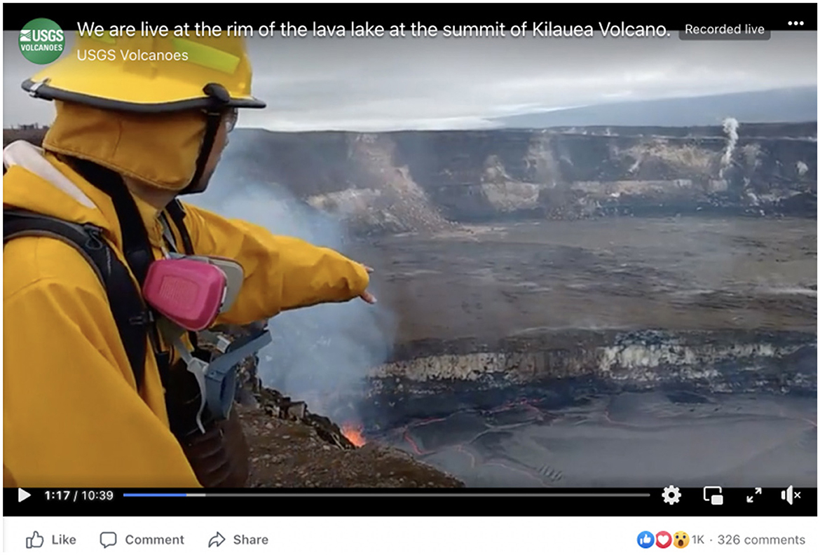
Figure 2. Screenshot of a Facebook live event March 19, 2018, where an HVO geologist describes monitoring the rising lava lake. The event commemorated the 10-year anniversary of the Halema‘uma‘u eruption at the summit of Kīlauea volcano. Total statistics for the two events: 405 comments, 1,370 likes, 60,400 viewsa, b. ahttps://www.facebook.com/watch/live/?ref=watch_permalink&v=1967239793304572; bhttps://www.facebook.com/USGSVolcanoes/videos/1967225443306007.
By April 2018, it was clear that the magmatic system beneath Kīlauea's summit and East Rift Zone (Figure 1) was becoming increasingly pressurized. HVO published a Volcanic Activity Notice on April 17, 2018, conveying that increased pressurization at Pu‘u‘o‘o may result in the formation of a new eruption site on or near the Pu‘u‘o‘o cone.2 On April 24, HVO released a second Volcanic Activity Notice that warned of a greater risk for rockfalls and small explosions from the summit lava lake in Halema‘uma‘u3 (Patrick et al., 2020). USGS Volcanoes' social media accounts featured imagery from the HVO website, showing summit lava lake high-stands and overflows4 as well as a time-lapse video of the formation of a perched lava pond within the crater of Pu‘u‘o‘o.5
On April 30, 2018, eruptive activity at Kīlauea changed dramatically. The crater floor of Pu‘u‘o‘o collapsed as the lava within and beneath the cone drained, and earthquakes began progressing eastward on the island as magma migrated through the East Rift Zone (Neal et al., 2019). HVO released another Volcanic Activity Notice on May 1.6 This notice stated that the collapse, along with earthquakes and deformation propagating down Kīlauea's East Rift Zone, indicated that an outbreak of lava farther down rift was possible, perhaps even within a residential area.
By May 2, 2018, residents of Leilani Estates (Figure 1) began to report cracks in roads and yards. By May 3, the neighborhood became the locus of a nearly 4-month-long eruption (Figure 3) that displaced residents, destroyed hundreds of homes, and dramatically changed the lives of lower-Puna (Figure 1) residents. Simultaneously, the lava lake in Halema‘uma‘u crater drained, and the Kīlauea summit caldera experienced a piecemeal collapse over several months. Individual collapse events generated fine ash that drifted downwind (Figure 3), and hundreds of daily earthquakes rattled the summit area (Neal et al., 2019).
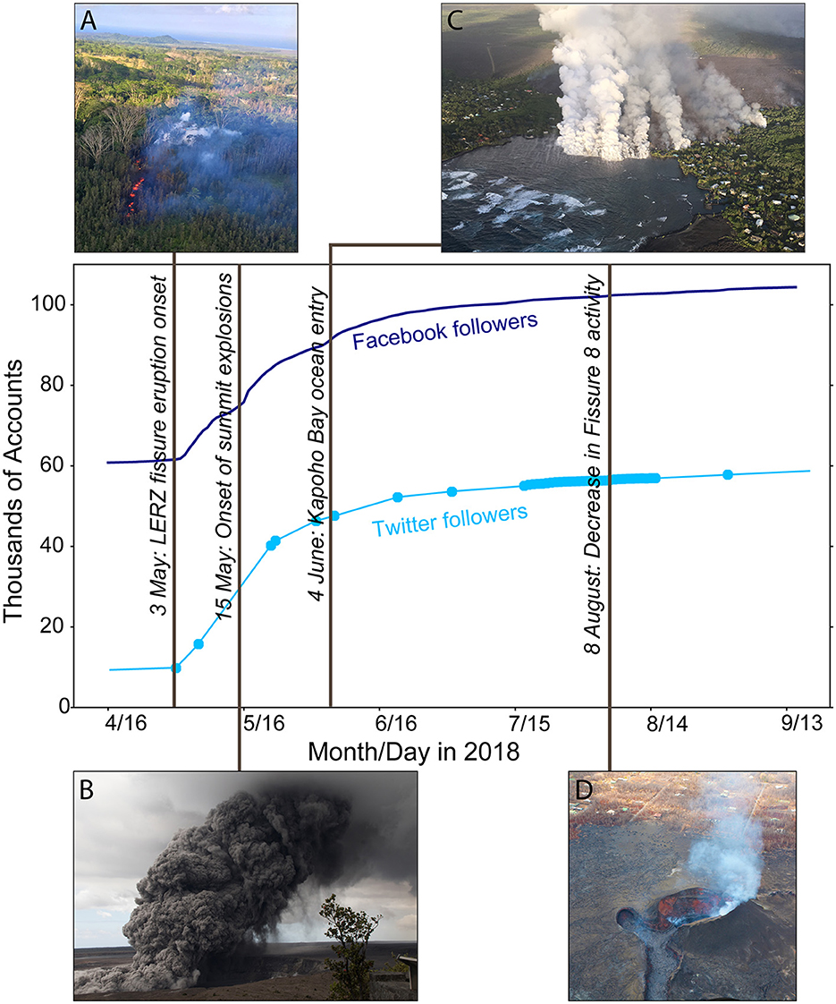
Figure 3. Audience growth for both Facebook and Twitter occurred rapidly following the onset of the Kīlauea lower East Rift Zone eruption on May 3, 2018. Similarly, followership gains occurred after significant events in the eruption timeline, notably the onset of explosions at Kīlauea's summit and as lava encroached into Kapoho and filled the bay. Data for Facebook are daily follower counts. Follower counts from Twitter were recorded for the first day of each month until the middle of July when daily tallies were made. USGS Photographs: (A) On May 3, 2018, at ~5:00 p.m. HST, fissures opened in the forested neighborhood of Leilani Estates and began erupting low lava fountains and volcanic gas (blue-tinged plume in image). (B) May 15, 2018, 11:05 a.m. HST, a dense ash plume rose from Kīlauea volcano summit. (C) An aerial photograph of June 4, 2018, 6:13 a.m. HST, shows the lava flow originating from Fissure 8 (not visible in photograph, Figure 1) entering Kapoho Bay. (D) The fissure 8 vent had minimal visible lava activity through September (this photo from August 8, 2018).
On the 1st day of the lower East Rift Zone eruption, HVO adopted an internal internet-based collaboration platform built on the open-source communication platform, Mattermost (Williams et al., 2020; Lowenstern et al., 2022). This tool was accessible as both a website and mobile application, and its primary use was for scientists to communicate eruption situational awareness to emergency response personnel. However, the tool's usefulness was much broader—volcano monitoring data were shared, photos and videos were uploaded directly from the field, scientific discussions occurred in discipline-specific channels, and the communication team could interact remotely with the eruption response team. The latter was vital to the success of the social media response.
4. Media team operation during the 2018 Kīlauea crisis
The dramatic changes at Kīlauea volcano in May 2018 emphasized the substantial need to communicate timely information to residents and visitors on the Island of Hawaii. As the crisis progressed, residents increasingly requested situational awareness updates via email to askhvo@usgs.gov and as comments and direct messages to the USGS Volcanoes' social media accounts. However, if released through traditional channels (VNS, website, TV, radio, and print media), the information could become out-of-date within hours (Williams et al., 2020). The nature of social media, including its ability to be swift, agile, and interactive, made it a powerful tool to increase the speed and reach of communication throughout the months of the crisis response (May–August). During the eruption, the USGS media team, which included visiting USGS staff working together closely with local HVO staff, created online text and video updates, developed a system for posting automatic status updates to social media, helped conduct press briefings and phone conferences, gave interviews, updated the HVO webpage with photos from the eruption, aided in setting up a live stream of summit activity on YouTube, and assisted in community briefings and Q&A sessions. While not every member of the media response was part of the social media team, the whole social media team contributed to the overall media response, which was led by HVO staff.
4.1. Researcher positionality
Most authors participated in the social media team during the 2018 eruption of Kīlauea, with varying degrees of knowledge about Kīlauea and experience communicating hazards. Stovall (Author 1) is a volcanologist and communication professional who lived in Hawaii before 2018 researching Kīlauea volcano. During nearly 6 years of residence, Stovall developed close working relationships with HVO scientists, taught students about Hawaiian volcanism, and participated in hazard outreach to local communities. The 2018 eruption was the first time Stovall witnessed the dramatic impacts of volcano hazards. Stovall communicated about volcanoes via USGS social media for 7 years before the 2018 eruption.
Ball (Author 2) is a volcanologist who had spent time in Hawaii as a student in an immersive volcanology field methods class before the 2018 eruption. Ball had self-taught expertise in geoscience communication and social media through personal blogging and a Twitter presence but had not interacted extensively with residents of the Island of Hawaii either online or in person.
Westby (Author 3) is a volcanologist stationed at the USGS Cascades Volcano Observatory in Vancouver, Washington. Before 2018, Westby served two 4-week stints at HVO, conducting education and outreach about Kīlauea's history and hazards, HVO's monitoring program, and learning how the public and public officials can receive information about changes at the volcano.
Poland (Author 4) is a volcanologist with expertise in studying volcano deformation and gravity change. Poland was stationed at HVO during 2005–2015, involved in the scientific and communication responses to numerous volcano and earthquake events. Poland developed a strong understanding of the local perception of volcanic hazards and the effectiveness of different outreach activities.
Wilkins (Author 5) is a volcanologist at the USGS office in Reston, Virginia, who provided surge-capacity assistance to the USGS Volcanoes social media team. Before 2018, Wilkins had several years of experience using social media for science communication at USGS. While Wilkins had visited Hawaii briefly before and had experience analyzing remote sensing data of Kīlauea lava flows as a college student, this was Wilkins's first experience responding to a volcanic crisis.
Mulliken (Author 6) is a Research Corporation of the University of Hawai‘i geologist working at HVO. During 2018, Mulliken was working with the DGGS branch of the Alaska Volcano Observatory and was deployed to Hawaii to aid in the Kīlauea eruption field response. Since 2020, Mulliken has been involved in HVO communication and works closely with the USGS social media team but is not a part of it. Mulliken grew up in Hawaii, near the summit of Kīlauea and appreciates first-hand the impact of volcanic events on Island of Hawai‘i residents and visitors and the importance of diverse communication strategies.
4.2. Ramping up to crisis communication
Before 2018, the USGS Volcanoes' social media team did not have a crisis communication plan. A loose formula for communicating eruption information on social media took several days to assemble and implement, which meant the social media response to the first few days of the crisis was largely improvised. Crisis response practices were primarily based upon the “intense media interest” scenario in a (then) draft of the USGS Cascades Volcano Observatory media management guide (Driedger and Westby, 2020).
Social media work was initially conducted by team members based in the contiguous U.S., not Hawaii. Principal social media priorities were to push out official activity updates (from both USGS and emergency response partners) and to post USGS photos and videos as they appeared on the HVO website. An event-specific hashtag (#KīlaueaErupts) was defined early and used consistently for primary posts on Facebook and Twitter, and imagery was duplicated on the two platforms. A standing priority was to answer all questions and relay citizen reports to HVO scientists. At the start of the event, addressing these critical questions was considered most important:
• What happened?
• Why did it happen?
• What will happen next?
• What action can I take?
Between the April 30 collapse of the Pu‘u‘o‘o crater floor and the May 4 magnitude 6.9 earthquake (Figure 1) (Neal et al., 2019), followership of the USGS Volcanoes' Facebook and Twitter accounts grew (Figure 3). In the week following the earthquake, USGS Volcanoes' Facebook posts were being seen by more Island of Hawaii residents than ever. The percentage of total USGS Volcanoes' Facebook posts being viewed by the local population grew from nearly 1% on May 3 to about 40% by May 11 (Figure 4), 1 week after the onset of lava flows in Leilani Estates (Figure 1). This statistic indicates that most new followers were from Hawaii.
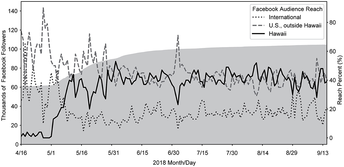
Figure 4. USGS Volcanoes' Facebook data from April 16 to September 15, 2018. Cumulative followers (shaded gray area, left axis) grew quickly during the 1st month of the eruption as a greater percentage of people from the State of Hawaii (solid black line, right axis) viewed content.
The social media team prioritized answering questions and providing updates with videos and imagery as quickly as permitted by HVO. Simultaneously, traditional media outlets were interested in the eruption and submitted fast-turnaround media inquiries to the USGS Office of Communications and Publishing—the primary USGS division for handling media inquiries. Some USGS Volcanoes' social media team members were designated subject matter experts for media interviews that could not be handled by HVO staff, limiting their full-time ability to help with social media.
4.3. Adding staff and field visits
The four USGS Volcanoes' social media team became overwhelmed in the 1st week of the eruption. On top of communicating eruption information, three social media team members were involved in organizing previously planned non-HVO-related meetings and events in the first 2 weeks of May. Due to this limitation on available staff, an additional USGS scientist with volcanic expertise was added to the social media team on May 11 in a surge capacity through June. Duties were quickly divided into 8–10-h shifts, 7 days per week. Team members were spread across several time zones, allowing coverage throughout the day (and partially overnight) in Hawaii.
In the 1st month, most of the social media work was conducted by team members on either the west or east coasts of the United States. In mid-May, team members began 2-week rotations onsite in Hawaii. Travel often overlapped, resulting in gaps in social media coverage (Figure 5). Primary responsibilities while in Hawaii were to assist HVO staff with community outreach, participate in press briefings, staff the HVO position at the joint Emergency Operations Center (EOC), and record daily YouTube video updates describing the eruption status (videos have an average of 46,000 views on the USGS YouTube channel). These tours in Hawaii allowed team members to understand the significance of the eruption response effort more intimately.
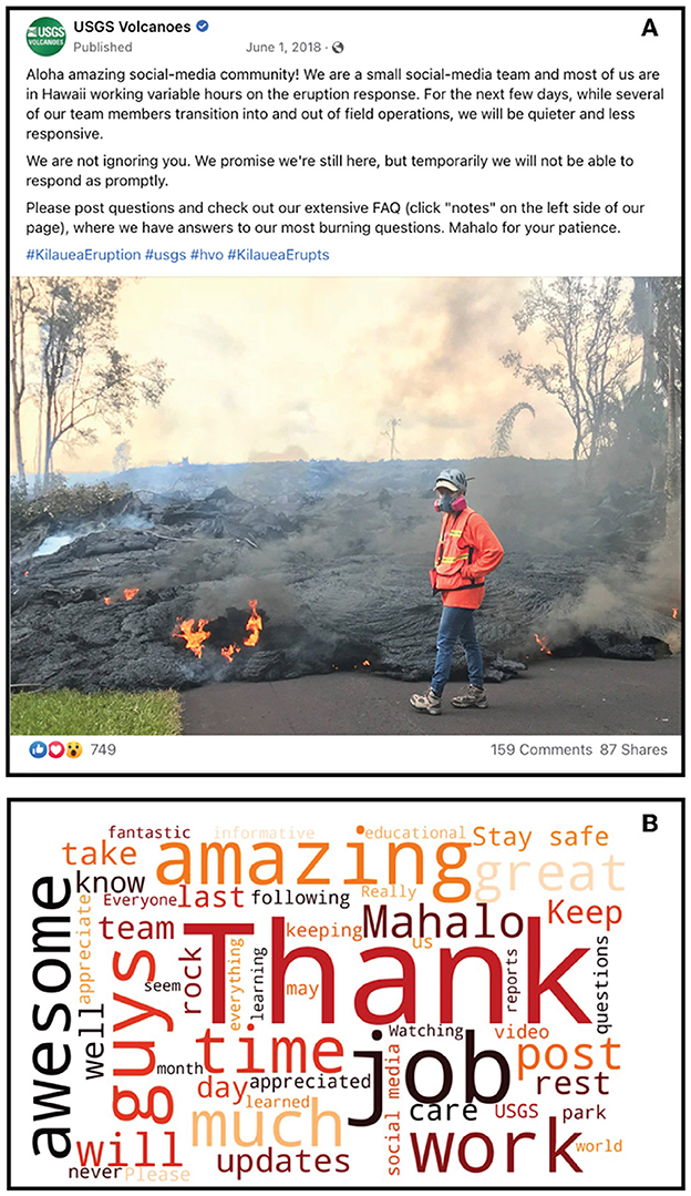
Figure 5. Specific posts were made during times when the social media team was going to be less able to post content and answer questions than usual (A). The photo in the post shows Wendy Stovall measuring the exact location of the flow front on a residential road in the Leilani Estates neighborhood. Comments and replies to these posts were overwhelmingly positive and included messages of thanks for staff providing information via social media as well as the people on the ground monitoring the eruption. The word cloud (B) represents the most frequently used words from the 159 comments to the post shown in (A), which is characteristic of positive-sentiment feedback received throughout the 2018 response.
5. Procedures and lessons learned
The USGS Volcanoes' social media team established a prioritized flow of information delivery. Following the checklist (Figure 6), content was posted on a schedule that provided predictability for those following the USGS Volcanoes' Facebook and Twitter accounts. Posting priority was defined by content type and the timeframe for each type to be released to the public.
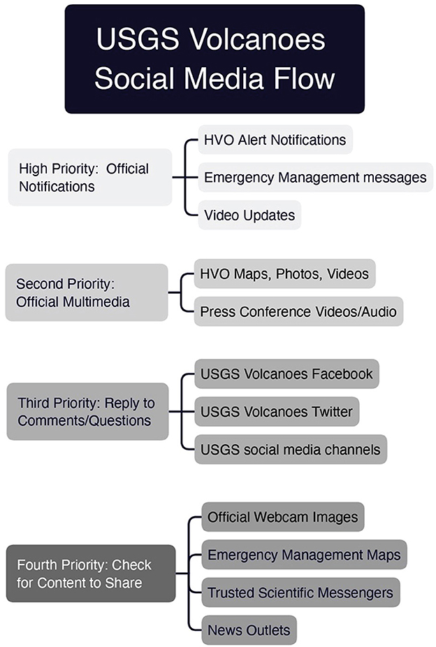
Figure 6. Prioritized checklist of content types and information shared on USGS Volcanoes' social media channels during the 2018 Kīlauea eruption response.
The highest priority was given to official eruption notifications. On a typical day, the HVO daily update was issued in the morning. The text from this update was copied onto Facebook and posted with photos taken from the field the previous night or from that morning's helicopter flight over the lower East Rift Zone eruption. The same photographs were used on Twitter with a short synopsis of the update and a link to the full text on the HVO website. Emergency messages from Hawaii County Civil Defense or Hawaii Volcanoes National Park were immediately shared or retweeted. Daily video updates were posted as soon as they were live on YouTube.
Second-tier content priority included multimedia from official sources. This included HVO maps of lava flow advancement, recent photographs, and videos from the field. If press conferences that featured HVO staff were recorded (either via audio or video), we shared those from the host organizations (e.g., Nā Leo TV or Big Island Video News7).
Once new content was posted, USGS Volcanoes' staff scoured prior posts and tweets for questions to answer. This was undoubtedly the most time-consuming task for the USGS Volcanoes' social media team, and it was the action that most fostered trust with followers (Goldman et al., in press). Once questions were addressed, we checked with other eruption information sources for content to share or retweet.
We generally adhered to communication guidelines suggested by the International Association of Volcanology and Chemistry of the Earth's Interior (IAVCEI) Subcommittee for Crisis Protocols (Newhall et al., 1999). However, due to the age of this article, the guidelines do not include specific information about social media. It is worth noting that in late 2018, the IAVCEI Communication Working Group within the Hazards and Risk Commission (members include USGS Volcanoes' staff) developed communication considerations for official accounts on social media (Supplementary material 1). These guidelines include many best practices developed during the 2018 USGS response.
5.1. Audience growth = Adaptive communication strategies
As with any significant event, having a plan in place is good but being flexible and adapting as situations evolve is imperative.
The 2018 Kīlauea volcanic crisis was widely publicized in the media and impacted people's livelihoods, tourism, public health, and safety. These impacts, plus the fascinating imagery, are reasons people sought more information about the eruption. This was especially true of the local population. As USGS Volcanoes' Facebook and Twitter followership grew (Figure 3), posts and tweets' reach (number of people who viewed content) also grew as others shared content.
The policy for posting content to social media was that it had to first be published on the HVO website. However, due to the compounding crises of losing the HVO facility to summit earthquake activity and managing the response to the ongoing eruption, it often took many hours for photos and videos from the field to be posted to the website. In the first 2 weeks of the eruption, this delayed content posting to social media. The audience more frequently asked for situational awareness information and was critical of the perceived slowness of photos and videos being shared on social media. To stay informed, followers increasingly viewed and relied upon information from unofficial accounts (Goldman et al., 2023) that sometimes displayed risky activities by eruption onlookers in hazardous areas closed to the public.
To increase the pace of information to the public, the order of information delivery shifted to meet the demand. By mid-May, content was first posted to social media and replicated on the HVO website. Internal communication via email and messaging software, Mattermost (Williams et al., 2020; Lowenstern et al., 2022), permitted the social media team to stay apprised of minute-to-minute developments, ask responding scientists clarifying questions, and access video and photos posted directly from the field as observations were made. HVO management set strict guidelines (Supplementary material 2) for the types of content that could be posted to social media and retained the ability to approve or veto items before posting. However, HVO staff were spared from the logistics of posting imagery and other content to either the website or social media.
A month into the 2018 crisis, the eruption became relatively steady state. After lava flows resulted in the loss of hundreds of homes, the main pathway of lava flowing eastward toward the ocean was established (Neal et al., 2019). Continued reporting from the national and international mainstream media kept global interest in events at Kīlauea high. Social media followership rose dramatically in the 1st month—Facebook audience grew by 50% and Twitter audience by 375% (Figure 3). With a stable eruption, continued engagement, and increasing followership, the social media team reassessed and shifted communication objectives to include a greater frequency of educational content rather than focusing on observations and official notifications. Content was tailored to follower requests identified in real-time. The number of frequently asked questions posted to Facebook and the HVO website grew through time. The team developed multimedia posts to communicate answers to these questions and showcase data collection and scientific insights (Figure 7).
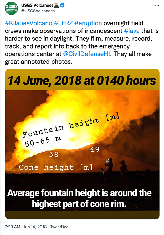
Figure 7. Example of a post to Twitter that featured a USGS photograph from the field with accompanying scientific information and educational content.
5.2. Stay in communication lane and share official information
A significant benefit of social media is the ability to amplify messages from partner organizations (Panagiotopoulos et al., 2016). The USGS Volcanoes' social media team shared and retweeted emergency management updates, official government evacuations, and closure orders posted on Hawaii County Civil Defense (local), Hawaii Emergency Management Agency (State), and Hawaii Volcanoes National Park (Federal) websites and social media streams. This meant that people who may not have been aware of those information sources had the chance to see them via USGS volcanoes. Furthermore, by sharing emergency management partner messages, non-Hawaii-based followers and the press were directed to official information rather than unofficial accounts (Sutton et al., 2015). In addition, the USGS could draw attention to the radio broadcasts and SMS-based update system being operated by Hawaii County Civil Defense, which provided information to people even in areas with spotty cellular reception or poor internet access. Finally, the USGS used social media to advertise and promote co-sponsored events (such as community meetings and ash safety briefings) conducted with State, County, and academic partners.
6. Successes
We now consider the social media response to the 2018 Kīlauea volcanic crises in the context of follower engagement and our team's ability to uphold best practices and principles of crisis communication (Coombs, 2010; Maal and Wilson-North, 2019). Overall, we conclude that the social media team provided critical, actionable hazard and safety information (Fearnley et al., 2018). The information shared was consistent, factual, and non-speculative. We aimed to speak with empathy and courtesy (McBride and Ball, 2022). Our actions were crafted to foster credibility and build trust (Haynes et al., 2008). We adapted, answered requests, and engaged in dialogue (Eriksson, 2018). The content we shared served our social-media community—it was relevant to those impacted by the eruption and kept more distant followers engaged, curious, and learning about the science of volcanoes.
6.1. Delivering consistent factual information
The USGS Volcanoes social media team worked closely with HVO eruption response staff throughout the eruption, promoting HVO messages and observations. The core social media team included two scientists who had previously served at HVO or conducted research at Kīlauea. This intimate knowledge of the volcano's history of eruption and unrest made it easier to quickly give contextual details to posts' content and provide factual answers. All team members had a volcanology background and expertise in science communication. We communicated regularly with each other via an internal “chat” system. When a question posed by a follower was suited for a specific team member's expertise or familiarity, we called upon them to answer or reached out to HVO staff if necessary.
Throughout the volcanic crisis at Kīlauea, the social media team made it standard to answer all questions and maintain back-and-forth communication with followers. As the eruption progressed, similar questions were being asked repeatedly. A shared document of common questions and answers was developed to ensure consistent information across all platforms. These became a set of frequently asked questions (FAQs) added to Facebook as “Notes” (a feature no longer available), which were vetted by HVO staff and added to the HVO website. As questions were posed, the social media team could point people to FAQs for more detailed information while providing personalized and empathetic answers that contained consistent responses.
6.2. Growing a community of informed followers
By being responsive, friendly, consistent, and thorough, the USGS Volcanoes' social media team built an informed and dedicated group of followers who became willing, themselves, to share knowledge, answer questions, and help police misinformation. Regular followers became knowledgeable of answers to frequently asked questions and sometimes commented on others' questions before the USGS Volcanoes' team (Figure 8). These “regulars” responded, answered follow-up questions, and became a welcome part of the conversational dynamic of the USGS Volcanoes' accounts. They often rallied to defend our positions and statements if adversarial comments appeared. USGS Volcanoes' team members saw value in the followers who spread correct information and provided encouragement in the form of “likes” or approving follow-up comments.
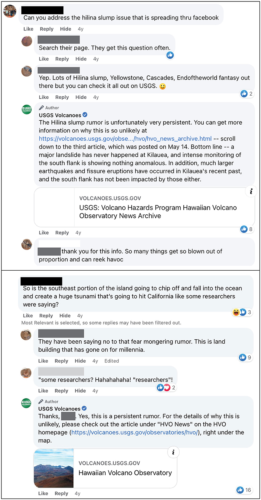
Figure 8. Two comment strings related to a common concern that the southern portion of the Island of Hawaii was going to slide off into the ocean in a catastrophic fashion. Followers addressed questions to USGS Volcanoes, and often the community answered with recommendations of where to find additional information.
6.3. Fulfilling traditional media requests
The 24-h news cycle increasingly relies on social media for scoops and current information (Farhi et al., 2021). While many local news sources had worked closely with HVO and were accustomed to interfacing with the established media and outreach coordinator, some national and international news outlets sought contact with HVO through the USGS Volcanoes' social media channels. The social media team sent these requests to the USGS Office of Communications and Publishing (OCAP), which maintained a central media-tracking spreadsheet and ensured requests were addressed. In cases when questions from the media could be answered quickly by the social media team, replies were sent directly without involving OCAP or already overtaxed HVO staff. In other cases, traditional media directly cited content from USGS Volcanoes' posts in news reports (McBride and Ball, 2022).
6.4. Meeting followers' requests and receiving citizen scientist reports
The USGS Volcanoes' social media channels were an easy way for followers to access daily information about the progress of the summit and rift-zone activity. We posted HVO maps, photographs, and videos, but imagery captured by USGS field personnel was vastly more significant than what we could share daily. Followers often requested map-based animations of eruption progression, additional videos, and even a live-stream camera. The social media team sometimes could fulfill these requests by piecing together short animations or videos, but we also conveyed requests to HVO. As time allowed, HVO and other USGS technical experts created animated map sequences8 that showed the evolution of lower East Rift Zone lava flows (Figure 1) and subsidence of the Kīlauea caldera.9 Through conversations with the National Park Service and agreements made with the central USGS social-media management, a live webcam was eventually installed at the summit of Kīlauea and streamed to the USGS YouTube channel.
Occasionally, affected residents attempted to report hazardous developments to HVO scientists and other authorities, which highlighted a communication gap. The general HVO email address and phone number were overwhelmed, and responses to inquiries were delayed. Because of the agility of social media and the speed with which the USGS social media team was able to respond, a process developed organically whereby citizen reports of ground cracks, gas emissions, and lava outbreaks were received on social media channels and relayed quickly to HVO field crews through Mattermost (Williams et al., 2020). For example, one resident regularly reported the temperature, width, and fume acidity of ground cracks on their property to HVO's gas team via Facebook. This led to HVO monitoring a site that they would otherwise not have known about or been able to access and had the ancillary benefit of building trust between the resident and HVO staff.
6.5. Experiencing appreciation
Research suggests that there was a general attitude of gratefulness for the work done by the HVO staff responding to the eruption (Goldman et al., 2023) and the USGS Volcanoes' social media team (Goldman et al., in press). Comments complementing posts' informative and educational content and appreciation for answering so many questions were common (Figures 5B, 8). Appreciation was also noted when we creatively communicated science and inserted well-timed attempts at humor. McBride and Ball (2022) posited that this communication method helped us connect and build empathy with at least some of our audience.
7. Challenges
Running a crisis communication response of any type is challenging. In news-heavy community crisis events, there are inevitably those who seek attention, spread rumors, or are dissatisfied with the information they are getting. Sometimes a concerted effort of multiple parts of an organization is needed to quell or correct falsehoods. This is especially the case when misinformation is spread, impacted communities are disrespected, or self-proclaimed experts spread dangerous disinformation that becomes viral (Hagley, 2021).
7.1. Addressing misinformation and disinformation
In all types of crises, people seek to make sense of events that might be difficult to comprehend. Storytelling is a part of the sensemaking process. The process of storytelling can sometimes lead to rumors and the spread of misinformation (Starbird et al., 2016; Starbird and Maddock, 2019) or disinformation. Misinformation is incorrect information that is not intended to mislead, but disinformation is false information that is spread deliberately to deceive (Starbird and Maddock, 2019). Disinformation tactics can elicit distrust in authoritative and official sources, such as the USGS. Andrews et al. (2016) suggested that official accounts can correct misinformation by refuting falsehoods with a composed and civil response that avoids condescending remarks.
It is challenging to battle disinformation directly, as the source may have reasons for spreading falsehoods (e.g., monetary gain from advertisement clicks). During volcanic crises, disinformation can be eclipsed when responsible agencies and accredited subject matter experts disseminate factual information quickly and often before it is channeled through sensationalizing outlets. Rumors were certainly an issue during the 2018 eruption, and HVO published a Volcano Watch article to combat misinformation.10
When false information and rumors were identified, USGS Volcanoes' staff posted corrections without reference to the offending source. An example of the USGS's role in dispelling damaging rumors occurred when hundreds of earthquakes per day were happening at the summit of Kīlauea volcano. Computer programs automatically located the events, and only those above magnitude three were reviewed by a seismologist. Due to the frequency of events, several earthquakes were inaccurately auto-located and shown to be occurring around Mauna Loa volcano. A person managing a non-USGS YouTube account posted a video highlighting these earthquakes and showed that some were being removed (actually, relocated) from the area around Mauna Loa. In the same YouTube video, this person claimed that Mauna Loa was building toward eruption and that the USGS was withholding information about an impending eruption and deleting data. The USGS Volcanoes' social media team immediately developed factual and concise messaging that refuted these claims. The specific message was, “Earthquakes are automatically located by software, which a human must check. Sometimes the software locations must be corrected, leading to earthquakes appearing to move or vanish from our records. We are not observing any unusual activity at #MaunaLoa.” Though factual arguments did not sway some followers, the number of questions about Mauna Loa decreased over time, and the topic was rarely raised in the latter months of the response.
7.2. Considering local sensitivities
During an eruption, particularly in Hawaii, responders must deal not only with the immediate threats to safety and property but with the history and sensitivities of residents affected by volcanic impacts. This can include past land and environmental conflicts, religious beliefs, cultural practices, etc.
The USGS Volcanoes' social media team dealt with several locally sensitive or controversial subjects. One example was the presence, and community history of the Puna Geothermal Venture (PGV), a geothermal power plant built in the lower East Rift Zone. The plant provided about one-quarter of the electrical power for the Island of Hawai‘i (Hawaii Energy Facts Figures, 2018) but, over its 25-year history, had been a source of some public concern.11 During the eruption, parts of PGV were inundated by lava, and it was determined that its geothermal wells needed to be filled, capped, and sealed. Additionally, chemicals stored onsite for geothermal well operations (n-pentane, a common additive to reduce the boiling point of water injected into wells; Evans et al., 2015) were removed, but not immediately. The Environmental Protection Agency cited PGV for hydrogen sulfide releases in 2013 (Higuchi, 2016), and residents were generally suspicious of the plant, including whether PGV activities had triggered fissure eruptions. A highly viewed social media video post of burning methane-producing blue flames through road cracks12 (Goldman et al., in press), which was initially deemed harmless by the social media team, ignited an argument about whether the gas was indeed methane or a new release of hydrogen sulfide (which is more toxic) from PGV. Repeated reassurances from USGS Volcanoes were not enough to quell the uproar, and subsequent posts about similar phenomena, or information about PGV, were restricted to bare facts and kept to a minimum.
Although numerous requests were made to the USGS for a live-stream of the lava-flow eruptions, it was not feasible (from both a bandwidth and technological standpoint), and limitations on personnel and access were also a factor. Another primary concern was the sensitivities of residents experiencing tremendous loss. Balancing sharing the visual beauty, excitement, and fascination of the event with concerns for those impacted was a recurring challenge.
A related sensitivity that became difficult to navigate was posting images of burning homes. General USGS policy is not to show these events, as it can be traumatic for residents to see their homes destroyed through a public platform. However, in some cases, evacuated residents had no access to their homes for weeks; images posted on USGS Volcanoes was one of the only ways to get information about conditions in restricted areas and to find photographic confirmation of the extent of lava inundation. In the case of the Kapoho Bay and Vacationlands subdivision, regular USGS helicopter overflights prompted inquiries from residents wanting to know if their homes had been destroyed. While this was a way to provide closure, the social media team encouraged residents to send direct messages to the USGS Volcanoes' accounts and HVO directly regarding specific video footage so that those conversations could be conducted privately. This solution appeared to be satisfactory, but due to the additional burden on the social media team, it was approached as an ad hoc courtesy and not part of the formal communication plan.
7.3. Meeting content and mission critical demands
During disasters, the desire for round-the-clock updates is amplified, and many people seek information wherever they can find it. This became obvious during the 2018 Kīlauea crisis when reports of the eruption “trended” on media channels like Facebook and Twitter.
Amid this turmoil, the USGS Volcanoes' Facebook and Twitter accounts posted updates about Kīlauea numerous times per day—up to a dozen per day during the height of the eruption crisis. However, there were still complaints about too few posts, and followers wanted more photo and video content. The demand for “more (social media) content now” was at odds with the government mandate for USGS communication to provide rapid situational awareness of volcanic events to emergency partners (first and foremost). Mission-critical work always rose above the call for more social media content. Several times during the eruption, particularly related to video and drone content, the USGS Volcanoes' team was obliged to remind commenters seeking more posts that the USGS is not a news outlet but has to conduct mission-critical work first.
A specific example of this challenge was the constant conversation about HVO's lack of multiple streaming videos, prompting the social media team to spend much time explaining HVO's priorities and technological constraints and access limitations in the field. To address resource limitations, posts were added that specified when there would be “radio silence” from team members due to more pressing duties, staffing changeovers, and other interruptions. These posts were generally greeted with support and praise from social media followers (Figure 5), and they served to humanize the social media team members for online audiences. These posts also reminded the public that the USGS's first and most important mission during the eruption was safety for crisis responders and affected communities.
Notably, no Joint Information Center (discussed in Driedger et al., 2008) was assembled for the 2018 Kīlauea eruption. Such a center would have combined all response agencies' communication professionals and provided the opportunity to share the load of informational requests.
7.4. Identifying and clearing bottlenecks
A related internal concern was a bottleneck for information flowing from HVO to websites and social media. During the 2018 response, the scientific team was committed to round-the-clock monitoring and data collection; interpretation to provide forecasts; and dealing with requests for information from emergency management, civil defense, and other public officials. While they provided products that could be publicly released (maps, updates), it fell to the media/social media team to obtain, vet, and distribute other material, such as photos and videos. While these were being collected as part of the monitoring activity, it was incumbent on the social media team to sort through and choose the most appropriate content to post to the website and social media channels and work with HVO staff to caption and catalog the imagery. In the early stages of the eruption, this task was made difficult by the remote location of the social media team. Photos and videos were stored on a computer hard drive in Hawaii, and internet bandwidth issues made it challenging to access shared file storage. Additionally, it was time-consuming for field staff to transfer media files and provide a file of accurate and informative captions after long and difficult field shifts.
One significant change, which alleviated many of these problems, was the Mattermost collaborative working platform (Williams et al., 2020; Lowenstern et al., 2022) discussed in Section 5.1. The social media team was given access to Mattermost after the 1st week of the eruption, which provided access to up-to-the-minute information and near-real-time photos and video. Using the robust messaging platform, social media team members could solicit timely information from the scientific team with minimal disruption to monitoring activities—requests were directed to an entire scientific team or multiple individual users and then answered by whoever was available.
7.5. Communicating uncertain outcomes
In an eruption crisis, inaccurate forecasts of future state or impacts can backfire and erode credibility, with consequences for people's safety. This is also true for other crisis response situations. Sometimes, social media audience members asked for precise predictions for what would happen next. However, USGS forecasts are carefully considered and framed as scenarios of possible outcomes. They can only be made relative to analogous past eruptions, the state of volcanic activity, and conditions under which an eruption progresses.
To provide the most transparent and honest information possible, the USGS Volcanoes' team echoed official notifications and aimed to precisely state knowns and unknowns, what can and cannot be forecast, and where uncertainties lie. For example, the question of “How long will the eruption last?” was typically answered not with “we don't know for sure,” but why it is difficult to know, with information about how eruptions can evolve, what the volcano has done in the past, and the limits of USGS sensors and forecasting abilities.13 If uncertainties were conveyed, they were voiced in relatable terms rather than ambiguous jargon. Admitting the limits of knowledge upset some followers and sometimes led them to spurious social media. Still, speculation erodes trust (Maal and Wilson-North, 2019) and is counterproductive to providing timely, accurate information.
7.6. Polite responses and policy breaches
Official USGS social media accounts strive for neutrality. Although difficult to convey tone in the written word, sometimes comments or questions from USGS posters might appear patronizing or out of touch with community needs, which can undermine critical messages during a crisis. This was occasionally an issue in comments made by both the official USGS Volcanoes' staff and followers. When followers' concerns were seen, we quickly aimed to remedy the issue with a genuine and empathetic reply, an explanation or restating of the original post, and requested courtesy be given in commentors' responses to others.
In many conversations, it is also important—but difficult—to consider a follower's level of expertise and comfort with a topic. A jargon-filled response can erode trust and give an ivory-tower flavor to communication, but overly simplistic language can be insulting (McBride, 2017). Asking questions or taking a moment to look over previous interactions with a follower was helpful in appropriately tailoring a response.
The expectation of politeness and courtesy extends to the social media community also. USGS Volcanoes' social media Facebook account has a clear comment policy (Supplementary material 3). Automatic filtering prevents public view of offensive language on Facebook (but not Twitter), and immediate action is taken to remove spam, offending, or hateful speech. Commenters who disregard rules are provided a reminder of the policy by the social media team and given a second chance. USGS staff can mute or ban repeat offenders from the ability to interact with USGS social media accounts. Protocol for dealing with troublesome commentors is as follows:
• Provide a quick policy reminder and a short factual response to any question.
• Hide comments if appropriate.
• Do not engage in a back-and-forth argument.
• Consider archiving and then deleting comments.
• Discuss banning repeat offenders with USGS social media lead.
As a Federal government agency, we must always consider that our actions are part of the public record. Therefore, deleting comments requires social media managers to record offending comments and the associated policy breach in a document before deleting them. Additionally, offensive commenters can only be banned if offensive behavior is repeated and egregious.
7.7. Making and reconciling unintended mistakes
The USGS Volcanoes' social media made rare factual errors during the 2018 eruption. There were also some insensitive, rushed responses or inaccurate descriptions. Admitting mistakes demonstrates integrity and benevolence (Hendriks et al., 2016), both fundamental traits that help maintain trust. Therefore, USGS Volcanoes aimed to acknowledge mistakes and issue corrections quickly. It is impossible to edit Twitter after posts or replies have been submitted. Still, corrections can be threaded to the original tweet, or the original tweet could be quoted in a new one with a corrected addendum. On Facebook, mistakes could be edited, but the team often either noted the edit in a follow-up comment or used strikethrough text to indicate that the change had been made. These techniques showed a commitment to transparency and were in keeping with overall DOI and government social media policy not to delete content.
8. USGS Volcanoes' social media strategy for future eruptions
The coordinated scientific plus traditional and social media responses to the 2018 Kīlauea eruptions were a proving ground for the practices that have become official guidelines for USGS Volcanoes' social media crisis communication. A seasoned team of official USGS social media “ambassadors” who have both remote and on-the-ground experience in crisis response means that future social-media responses to volcanic events can be organized quickly and with clearly defined roles. A rotational posting schedule exists for routine observatory communication and can be modified to accommodate increased activity from any observatory. Best practices created ad hoc during the 2018 response are continually updated and revised for future volcanic crises.
8.1. Testing the social media strategy during Kīlauea and Mauna Loa eruptions
By early 2019, magma was refilling the Kīlauea's depleted summit magma storage region (Poland et al., 2019). And in the 2 years following the 2018 eruption, a water lake formed within the collapsed Halema‘uma‘u Crater (Flinders et al., 2022). In late November and early December 2020, geodetic measurements indicated magma was moving from the storage region toward the ground surface at Kīlauea's summit.14
On the night of December 20, 2020, magma reached the surface. Fissures opened along the wall of Halema‘uma‘u Crater, and lava poured down the steep slopes. The water lake quickly boiled away, forming billowing clouds of vapor, and lava began pooling on the crater floor. The eruption lasted into May 2021, was confined to the crater, and the main hazard was increased volcanic gas emissions for areas downwind.
With the experience of 2018, the USGS Volcanoes' social media team quickly ramped up the effort to report on and respond to inquiries about the new eruption. The primary HVO communication professional retired earlier in 2020, and other HVO staff without 2018 communication experience backfilled that role. HVO notified the VSC social media team immediately when the activity began. The following morning, the four-person team established a schedule to ensure at least one person was on duty to post content and respond to questions. We defined “social media crisis response” time as monitoring social media 18 h per day in 6-h shifts with 4 people on rotation, essentially covering the hours between 9 a.m. on the East Coast to 10 p.m. in Hawai‘i. Due to the uncertain progression of the eruption, schedules were set only a few days in advance.
As in 2018, there was an internal online collaborative communication space (MS Teams) to share information. Two staff members at HVO managed website content, including gathering images, creating publishable videos of the eruption activity, and posting content, including maps and infographics, to the HVO website in the morning and afternoon. Different from 2018, the two staff dedicated to HVO website management prevented a bottleneck in information flow. The social media team shared USGS photos, videos, maps, and infographics as they were made available. Throughout the eruption, the social media team remained vigilant in answering questions from followers as quickly as possible.
The first 2 weeks of the eruption drew the most media attention, with local HVO staff responding to most of the inquiries. As in 2018, some social media staff answered inquiries from traditional media, but the demand was much less than in 2018, and diminished as the eruption remained confined to Halema‘uma‘u Crater. The eruption stabilized into a pattern of lava flowing into and filling the crater with a rising lava lake, vents being overtopped, and “islands” of solidified lava floating around the surface (Segall et al., 2022). These events proved curious to social media followers, but without significant and visually destructive hazards to communicate, overall interest was lower than in 2018, and the role of the social media team was scaled down. Staffing hours reverted to a regular schedule of one person on duty for an 8-h shift with occasional check-ins beyond that to answer questions. By May 2021, active lava ceased to be seen on the surface.
On September 29, 2021, lava fountains again erupted from Kīlauea's Halema‘uma‘u Crater, pouring lava on top of the lava lake that had formed in late 2020 and earlier in 2021.15 The social media team rapidly responded, enacting the “social media crisis response” protocol. However, the decision to scale down came more quickly this time (within days), as it was apparent that the eruption once again did not pose significant hazards to people or property.
During 2020–2022, HVO's attention was also focused on Mauna Loa.16 The most recent previous eruption of the volcano was in 1984 (Lockwood et al., 1987), but seismic and ground deformation data, which had been mostly elevated above background levels since late 2014, indicated that the magmatic system was pressurizing and could erupt with little warning (Thelen et al., 2017). HVO staff heightened efforts to coordinate with State and County emergency management officials and plan long-term for an eruption response. A marked uptick in activity began in September 2022, which prompted HVO to issue official notifications17, 18 and switch to daily updates for Mauna Loa in early October. Volcano Watch articles throughout the fall were either dedicated to Mauna Loa16 or mentioned the need for preparedness in the event of an eruption.19 HVO staff coordinated with Hawaii County Civil Defense to schedule public community meetings in October, November, and December in areas of the Island of Hawai‘i potentially at risk from Mauna Loa lava flows. Three in-person meetings were held before the eruption occurred. The meetings were streamed locally and on Facebook Live. The meetings provided information about activity and encouraged residents to build relationships with new or existing community groups (for example, CERT groups—Community Emergency Response Teams), seek preparedness and hazard information from USGS and partner resources (for example, Hawaii County Civil Defense Agency family emergency plans and the Hawaii Interagency Vog Information Dashboard), and follow Hawai‘i County and State guidance related to any evacuation measures.
Around 11:30 p.m. HST on Sunday, November 27, 2022, an eruption began in Mauna Loa's summit caldera, and HVO raised the alert level and aviation color code.20 By early the following morning, the eruption was localized on the volcano's Northeast Rift Zone,21 where vents at around 3,600 meters elevation fed multiple lava flows until activity focused to a single site, designated “Fissure 3” (being the third discrete fissure to have formed on the rift zone). Lava flows quickly channelized and moved downslope into unpopulated areas, cutting road access and power to the National Oceanic and Atmospheric Administration Mauna Loa Baseline Observatory on the volcano's north flank. By November 30, forward movement of the main Fissure 3 lava flow slowed significantly as it reached gentler topographic slopes and spread out. Ultimately, lava stalled about 3 km from the Daniel K. Inouye Highway, an important east-west transportation corridor. Eruptive activity waned significantly on December 8; by December 10, lava output at the vent had ceased, and sulfur dioxide emissions were near background levels.22 HVO lowered the alert level and aviation color code, indicating the volcano was no longer erupting on December 13.23
The night it began, HVO quickly informed the USGS Volcanoes social media team of the Mauna Loa eruption. The USGS Volcanoes' social media team remained in frequent contact with HVO staff in the following hours and generated the first informational post (not counting the automated eruption alert post) at 11:48 p.m. HST on November 27, noting the change in the alert level and aviation color code, describing the eruption onset, and highlighting webcam imagery from the summit. HVO released several formal notifications24, 25 about the activity in the first hours of the eruption, which were echoed in a series of social media posts. An important theme in early posts was to address concerns that the eruption had entered the Southwest Rift Zone (it had not). The USGS Volcanoes social media team answered questions, identified sources of more information on preparedness and monitoring data, and reinforced information from HVO regarding the nature and status of the eruption.
Traditional media attention was intense during the first full day of the eruption. A virtual Joint Information Center (JIC) allowed staff from HVO, USGS OCAP, Hawaii Volcanoes National Park, Hawaii County Civil Defense Agency, and the State of Hawaii Emergency Management Agency to be in constant virtual contact via a virtual meeting and chat platform. There, they discussed agency messaging and the sequencing of communication to the media and the public. The USGS Office of Communications organized daily, morning, virtual video and telephone press briefings with representatives from JIC agencies to provide situational awareness information to all interested media outlets simultaneously, a similar approach used in the 2018 eruption. USGS Volcanoes social media team members participated in the JIC and, as in 2018, assisted HVO in responding to traditional media inquiries. The JIC coordinated the timing of social media posts when new and important information was to be released, tagged each other's accounts, and amplified each other's content to ensure consistent messaging among responding agencies.
Over the 2 weeks of the Mauna Loa eruption response, the social media team posted about 100 photos, videos, or other pieces of content to each of the three primary social media platforms (Twitter, Facebook, and Instagram, e.g., Figure 9). HVO deployed a live stream video camera aimed at Fissure 3, which was added to the USGS YouTube channel by the 5th day of the eruption. During the eruption, YouTube gained about 13,000 followers with 1.8 million views (1 million of those were for the live stream). Some social media posts had more than 100 follow-on comments, including questions from followers and answers from USGS Volcanoes staff or others. According to social media analytics, there were more than 8,200 comments to USGS Volcanoes' posts between November 27 and December 13, 2022. As in 2018, we had significant gains in followership (about 39,000 total), the reach of the posts was extensive (about 10 million unique individuals), and engagement was high (1.5 million unique individuals). Instagram, which wasn't used in 2018, saw the largest gains of the three platforms, with a 23% increase in followers, while Facebook and Twitter gained 6.5 and 14%, respectively. And as in 2018, the reach for our Mauna Loa eruption coverage was primarily to people who live in Hawaii. Four of the top seven locations of people viewing USGS Volcanoes Facebook content were in the State, with the top ranking coming from Hilo, the largest city on the Island of Hawaii.
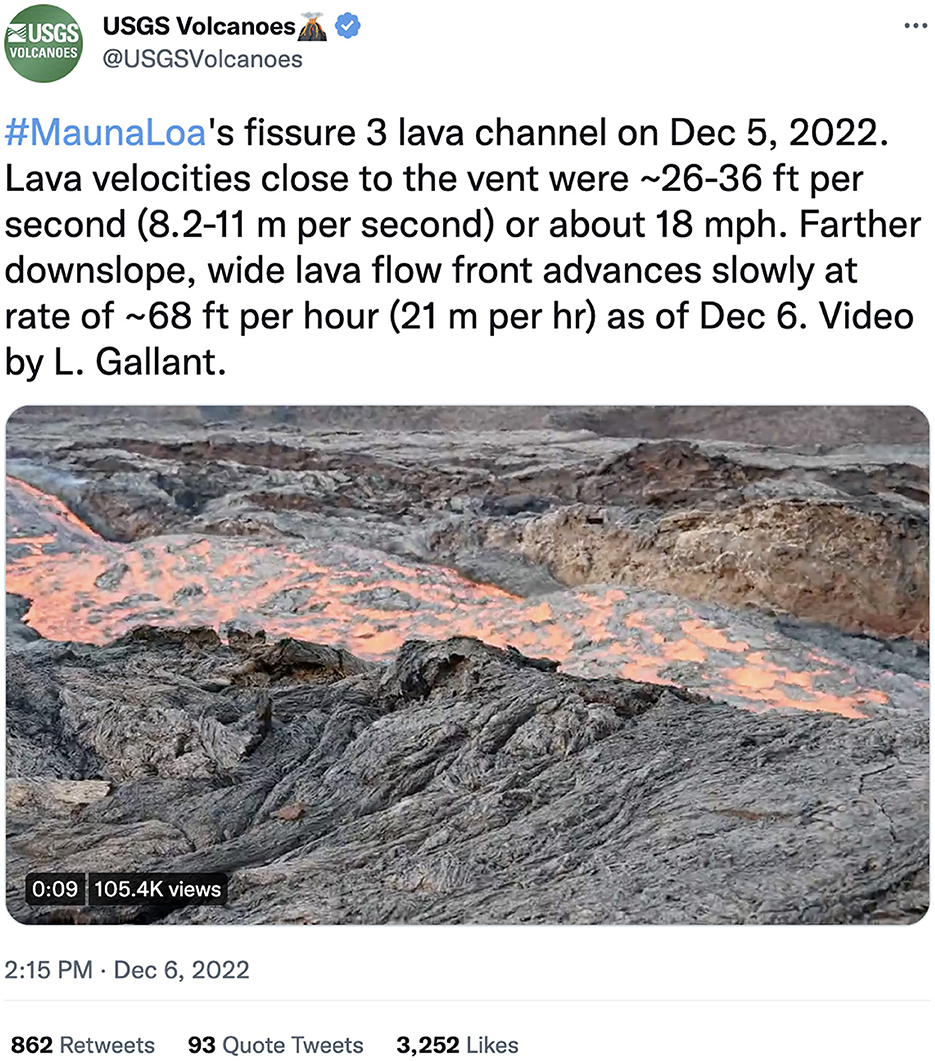
Figure 9. Image of one of the most popular tweets from the Mauna Loa eruption. This videoa, published first on the HVO website, was viewed over 105,000 times and shows the rapid movement of lava through a channel fed by Fissure 3. ahttps://twitter.com/USGSVolcanoes/status/1600252502217211904.
In summary, thanks to the social media experience in 2018 and techniques tested and refined in 2020 and 2021, the social media team was quickly integrated into the HVO and VSC eruption response communication team. Additional staff with experience in writing and posting content to social media were brought into the team, and 8-h shifts covering 18 h per day were assigned by the 2nd day of the crisis. A USGS strategy to provide information and answer questions via social media has now been implemented in multiple eruption crises. Each successive response incorporates lessons learned from previous experiences. The ability to communicate quickly and directly via social media with Island of Hawaii residents, and to answer their questions, has, in the view of authors, added important value to and extended the reach of USGS communication efforts during eruption responses.
9. Summary
Research has shown that information disseminated by official sources is better received and acted upon when those sources are trusted—that is, perceived to be transparent, competent, benevolent, and acting with integrity (Petty and Wegener, 1998; Seeger, 2006; Covello, 2010; Besley et al., 2021). Sustained outreach and two-way communication are important ways to build trust, and social media provides a powerful tool to do so. Not only does social media operate in near-real-time, but it also allows public members a chance to interact with science organizations in a way not possible with traditional media or static websites. This interaction humanizes people on both sides of the screen and contributes to the understanding and awareness of information-seekers of all kinds.
Although prior eruption response communication by USGS volcano observatories has involved substantial interaction with both traditional media and affected communities (Neal et al., 2005; Driedger et al., 2008; Frenzen and Matarrese, 2008; Brantley et al., 2019), the 2018 eruption of Kīlauea was the first opportunity to test the USGS Volcanoes' social media accounts as crisis communication tools. Given the difficulties of cascading hazards experienced by HVO, including the loss of the main facility, it was a benefit to have the social media team primarily offsite for the duration of the eruption and, therefore, unaffected by HVO's displacement. However, it would benefit the USGS Volcanoes' social media team to have a dedicated HVO staff member. Internal communication within HVO and the responding team of scientists, and the ability to deliver timely and accurate information to audiences via social media, was greatly enhanced by online collaboration software. Information provided through the USGS Volcanoes' social media accounts helped to build a growing, supportive online community that was both local and global in its reach.
While the USGS Volcanoes' social media strategy and experience in 2018 were shaped by USGS policy, communication capabilities, resources (staffing, time, and expertise), and the cultural landscape of Hawaii, lessons learned may be applicable at other observatories and similar science agencies in crisis response. Fostering community relationships, emphasizing transparency, admitting limitations, and interacting consistently and often with different audiences can benefit any observatory, particularly in building trust with the local population. We hope that the lessons learned in 2018 and applied during subsequent smaller-scale eruption responses in Hawaii can help create effective social media communication plans for a wide range of crisis responses.
Data availability statement
The original contributions presented in the study are included in the article/Supplementary material, further inquiries can be directed to the corresponding author.
Author contributions
Most authors (WS, JB, EW, MP, and AW) were part of the USGS Volcanoes' social media team during the 2018 Kīlauea eruption and posted original content and answered follow-up questions on Facebook and Twitter. WS is the USGS Volcanoes' social media team lead and conducted the literature review and wrote the bulk of this manuscript. JB was the primary Twitter affiliate during 2018 and contributed to Sections 6, 7, 9, and several figures. EW was the primary Facebook affiliate during 2018 and provided early input to the manuscript's organization, reviewed drafts, and added material throughout. MP's primary role was answering Facebook questions during the 2018 crisis, he contributed to the manuscript's HVO background section, and provided reference material for recent research at Kīlauea. AW was the surge-capacity addition to the USGS Volcanoes' group in 2018 and contributed to the structure and flow of the manuscript through a thorough review. KM became involved in HVO communication in 2020 and provided information that was shared during the 2020 and 2021 Kīlauea and 2022 Mauna Loa eruptions. All authors contributed to the article and approved the submitted version.
Funding
Funding for this research was fully supplied by the United States Geological Survey, a division of the Department of the Interior, U.S. Federal Government.
Acknowledgments
Sharing eruption information through the USGS Volcanoes' social media channels would not have been possible without the hard work undertaken by the USGS staff members involved in the eruption response. We thank Cheryl Cameron for providing insight into the history of social media at the Alaska Volcano Observatory. We acknowledge the contributions and prodding of the social media audiences on both Facebook and Twitter—we've learned much more about effective communication because of your persistence. USGS IT and Communications staff members helped to keep information flowing and enabled us to manage demands for more. Heartfelt thanks go out to the various community members in Hawaii who showed up with food and corresponding kindness to ensure the bellies and hearts of people involved in the eruption response were nurtured. Our work was greatly improved by peer reviews from Tina Neal, David Ramsey, Sara McBride of the USGS, and three reviewers. Any use of trade, firm, or product names is for descriptive purposes only and does not imply endorsement by the U.S. Government.
Conflict of interest
KM was employed by Research Corporation of the University of Hawaii.
The remaining authors declare that the research was conducted in the absence of any commercial or financial relationships that could be construed as a potential conflict of interest
Publisher's note
All claims expressed in this article are solely those of the authors and do not necessarily represent those of their affiliated organizations, or those of the publisher, the editors and the reviewers. Any product that may be evaluated in this article, or claim that may be made by its manufacturer, is not guaranteed or endorsed by the publisher.
Supplementary material
The Supplementary Material for this article can be found online at: https://www.frontiersin.org/articles/10.3389/fcomm.2023.976041/full#supplementary-material
Footnotes
1. ^https://www.usgs.gov/centers/volcano-science-center
2. ^https://volcanoes.usgs.gov/hans2/view/notice/DOI-USGS-HVO-2018-04-17T14:51:15-07:00
3. ^https://volcanoes.usgs.gov/hans2/view/notice/DOI-USGS-HVO-2018-04-24T19:17:20-07:00
4. ^https://www.youtube.com/watch?v=fQRq4jdAU_s
5. ^https://www.facebook.com/watch/?v=2003197056375512
6. ^https://volcanoes.usgs.gov/hans2/view/notice/DOI-USGS-HVO-2018-05-01T07:33:24-07:00
7. ^https://www.youtube.com/watch?v=YEt_sFoJ8kg
8. ^https://www.youtube.com/watch?v=lr_Gqu7HGPM
9. ^https://www.youtube.com/watch?v=-5pHpsY9cp0
10. ^https://www.usgs.gov/observatories/hvo/news/volcano-watch-turn-usgs-and-other-trusted-sources-kilauea-eruption-info
11. ^https://www.washingtonpost.com/news/powerpost/paloma/the-energy-202/2018/06/18/the-energy-202-kilauea-s-eruption-reignites-debate-over-hawaii-s-geothermal-plant/5b2652f21b326b3967989b27/
12. ^https://www.facebook.com/watch/?v=2039809729380911
13. ^https://www.facebook.com/USGSVolcanoes/photos/a.984262971602264/2148821148479768
14. ^https://www.usgs.gov/news/volcano-watch-small-notable-magma-intrusion-kilaueas-summit
15. ^https://www.usgs.gov/news/volcano-watch-new-eruption-halemaumau
16. ^https://www.usgs.gov/observatories/hvo/news/volcano-watch-recent-events-mauna-loa-remind-us-be-prepared-quick-changes
17. ^https://volcanoes.usgs.gov/hans2/view/notice/DOI-USGS-HVO-2022-09-23T13:24:04-07:00
18. ^https://volcanoes.usgs.gov/hans2/view/notice/DOI-USGS-HVO-2022-10-05T19:26:56-07:00
19. ^https://www.usgs.gov/observatories/hvo/news/volcano-watch-earthquakes-and-volcanoes-recipe-preparedness
20. ^https://volcanoes.usgs.gov/hans2/view/notice/DOI-USGS-HVO-2022-11-28T01:28:44-08:00
21. ^https://www.usgs.gov/observatories/hvo/news/volcano-watch-mauna-loa-reawakens-0
22. ^https://www.usgs.gov/observatories/hvo/news/volcano-watch-response-mauna-loas-2022-eruption
23. ^https://volcanoes.usgs.gov/hans2/view/notice/DOI-USGS-HVO-2022-12-13T08:57:10-08:00
24. ^https://volcanoes.usgs.gov/hans2/view/notice/DOI-USGS-HVO-2022-11-28T04:32:59-08:00
25. ^https://volcanoes.usgs.gov/hans2/view/notice/DOI-USGS-HVO-2022-11-28T09:00:26-08:00
References
Andrews, C. A., Fichet, E. S., Ding, Y., Spiro, E. S., and Starbird, K. (2016). “Keeping up with the Tweet-dashians: the impact of ‘official-accounts on online rumoring,” in Proceedings of the 19th ACM Conference on Computer-Supported Cooperative Work and Social Computing - CSCW'16, New York, NY: ACM Press, 451–464.
Auxier, B., and Anderson, M. (2021). Social Media Use in 2021 | Pew Research Center. Pew Research Center. Available online at: https://www.pewresearch.org/internet/2021/04/07/social-media-use-in-2021/ (accessed October 19, 2022).
Babb, J. L., Kauahikaua, J. P., and Tilling, R. I. (2011). The story of the Hawaiian Volcano Observatory – A remarkable first 100 years of tracking eruptions and earthquakes. U.S. Geological Survey General Inform Prod. i−63, 135. doi: 10.3133/gip135
Besley, J. C., Lee, N. M., and Pressgrove, G. (2021). Reassessing the variables used to measure public perceptions of scientists. Sci. Commun. 43, 3-32. doi: 10.1177/1075547020949547
Bevens, D., Takahashi, T. J., and Wright, T. L. (1988). The Early Serial Publications of the Hawaiian Volcano Observatory. Honolulu, HI: Hawaiian Natural History Association V.1., V.2., V. 3.
Brantley, S. R., Kauahikaua, J. P., Babb, J. L., Orr, T. R., Patrick, M. R., Poland, M. P., et al. (2019). “Communication strategy of the U.S. geological survey hawaiian volcano observatory during the lava-flow crisis of 2014-2015, Kilauea Volcano, Hawai'i,” in Field Volcanology: A Tribute to the Distinguished Career of Don Swanson, eds M. P. Poland, M. O. Garcia, V. E. Camp, and A. Grunder (Geological Society of America), 351–373 doi: 10.1130/2018.2538(16)
Bull, K. F., and Buurman, H. (2013). An overview of the 2009 eruption of Redoubt Volcano, Alaska. J. Volcanol. Geother. Res. 259, 2–15. doi: 10.1016/j.jvolgeores.2012.06.024
Chen, Q., Min, C., Zhang, W., Wang, G., Ma, X., and Evans, R. (2020). Unpacking the black box: How to promote citizen engagement through government social media during the COVID-19 crisis. Comput. Human Behav. 110, 106380. doi: 10.1016/j.chb.2020.106380
Coombs, W. T. (2010). “Parameters for crisis communication,” in The Handbook of Crisis Communication, eds W. T. Coombs and S. J. Holladay (Hoboken, NJ: Blackwell Publishing), 17–53. doi: 10.1002/9781444314885.ch1
Covello, V. T. (2010). “Strategies for overcoming challenges to effective risk communication,” in Handbook of Risk and Crisis Communication, eds R. Heath and H. O'Hair (New York, NY: Taylor and Francis), 143–167. doi: 10.4324/9781003070726-9
Curran, K., and McCarthy, S. (2009). “Really Simple Syndication (RSS),” in Encyclopedia of Information Science and Technology, 2nd Edition. Hershey, PA: IGI Global, 3213–3218.
Driedger, C. L., Neal, C. A., Knappenberger, T. H., Needham, D. H., Harper, R. B., and Steele, W. P. (2008). “Hazard information management during the autumn 2004 reawakening of Mount St. Helens Volcano, Washington,” in A Volcano Rekindled: The Renewed Eruption of Mount St. Helens, 2004–2006, eds. D. R. Sherrod, W. E. Scott, and P. H. Stauffer (U.S. Geological Survey Professional Paper 1750), 15.
Driedger, C. L., and Westby, E. G. (2020). USGS Cascades Volcano Observatory news media management guide - General protocols and templates: U.S. Geological Survey Circular 1462. p. 53. doi: 10.3133/cir1462
Eriksson, M. (2018). Lessons for crisis communication on social media: A systematic review of what research tells the practice. Int. J. Strateg. Commun. 12, 526–551. doi: 10.1080/1553118X.2018.1510405
Evans, W. C., Bergfeld, D., Sutton, A. J., Lee, R. C., and Lorenson, T. D. (2015). Groundwater chemistry in the vicinity of the Puna Geothermal Venture power plant, Hawai'i, after two decades of production: U.S. Geological Survey Scientific Investigations Report 2015-5139. p. 26. doi: 10.3133/sir20155139
Farhi, F., Saidani, S., and Jeljeli, R. (2021). Determinants of dependence on social media for accessing news a study on a sample of journalists in the newsroom. Psychol. Educ. 58, 3531–3543. doi: 10.17762/pae.v58i3.4533
Fearnley, C., Winson, A. E. G., Pallister, J., and Tilling, R. (2018). “Volcano crisis communication: challenges and solutions in the 21st century,” in Observing the Volcano World. Advances in Volcanolog, eds C. J. Fearnley, D. K. Bird, K. Haynes, W. J. McGuire, and G. Jolly (Cham: Springer), 3–21. doi: 10.1007/11157_2017_28
Fiske, S. T., and Dupree, C. (2014). Gaining trust as well as respect in communicating to motivated audiences about science topics. Proc. Natl. Acad. Sci. U. S. A. 111, 13593–13597. doi: 10.1073/pnas.1317505111
Flinders, A. F., Kauahikaua, J. P., Hsieh, P. A., and Ingebritsen, S. E. (2022). Post audit of simulated groundwater flow to a short-lived (2019 to 2020) crater Lake at Kīlauea Volcano. Groundwater 60, 64–70. doi: 10.1111/gwat.13133
Frenzen, P. M., and Matarrese, M. T. (2008). “Managing public and media response to a reawakening volcano: lessons from the 2004 eruptive activity of Mount St. Helens,” in A Volcano Rekindled: The Renewed Eruption of Mount St. Helens, 2004–2006, eds. D. R. Sherrod, W. E. Scott, and P. H. Stauffer (U.S. Geological Survey Professional Paper 1750).
Gardner, C. A., and Guffanti, M. C. (2006). U.S. Geological Survey's Alert Notification System for Volcanic Activity. U.S. Geological Survey Fact Sheet 3139.
Goldman, R. T., McBride, S. K., Stovall, W. K., and Damby, D. E. (in press). “Wow! Thanks for sharing!”: USGS and Facebook user dialogue and sentiment during Kilauea 2018 eruption. Front. Commun.
Goldman, R. T., Stovall, W. K., Damby, D., and McBride, S. (2023). Hawai'i residents' perceptions of Kilauea's 2018 eruption information. Volcanica. 6, 19–43. doi: 10.30909/vol.06.01.1943
Hagley, Z. (2021). The disaster of “alternative facts”: misinformation and disaster management in Grenada. Caribbean Stud. 49, 29–59. doi: 10.1353/crb.2021.0011
Hawaii Energy Facts and Figures (2018). Available online at: https://energy.hawaii.gov/wp-content/uploads/2018/06/HSEO_2018_EnergyFactsFigures.pdf (accessed October 27, 2022).
Haynes, K., Barclay, J., and Pidgeon, N. (2008). The issue of trust and its influence on risk communication during a volcanic crisis. Bull. Volcanol. 70, 605–621. doi: 10.1007/s00445-007-0156-z
Hendriks, F., Kienhues, D., and Bromme, R. (2016). Disclose your flaws! Admission positively affects the perceived trustworthiness of an expert science blogger. Stud. Commun. Sci. 16, 124–131. doi: 10.1016/j.scoms.2016.10.003
Higuchi, D. (2016). EPA Finds Puna Geothermal Venture Violated Chemical Safety Rules | U.S. EPA News Releases | US EPA. News Releases from Region 09. Available online at: https://archive.epa.gov/epa/newsreleases/epa-finds-puna-geothermal-venture-violated-chemical-safety-rules.html (accessed June 2, 2022).
Lipman, P. W., and Mullineaux, D. R. (1981). The 1980 Eruptions of Mount St. Helens. Washington, DC: U.S. Geological Survey. p. 844. doi: 10.3133/pp1250
Lockwood, J. P., Dvorak, J. J., Thomas, T. E, Koyanagi, R. Y., Okamura, A. T., Summers, M. L., et al. (1987). “Mauna Loa 1974-1984: A decade of intrusive and extrusive activity,” in Volcanism in Hawaii, eds. R. W. Decker, T. L. Wright, and P. H. Stauffer.
Lowenstern, J. B., Wallace, K., Barsotti, S., Sandri, L., Stovall, W., Bernard, B., et al. (2022). Guidelines for volcano-observatory operations during crises: recommendations from the 2019 volcano observatory best practices meeting. J. Appl. Volcanol. 11, 1–24. doi: 10.1186/s13617-021-00112-9
Maal, M., and Wilson-North, M. (2019). Social media in crisis communication–the “do's” and “don'ts.” Int. J. Disaster Resil. Built Environ. 10, 379–391. doi: 10.1108/IJDRBE-06-2014-0044
McBride, S. K. (2017). The Canterbury tales : an insider's Lessons and Reflections from the Canterbury Earthquake Sequence to Inform Better Public Communication Models : A Thesis Presented in Fulfilment of the Requirements for the Degree of Doctor of Philosophy in English and Media Studies at Massey University, Wellington, New Zealand. Available online at: https://mro.massey.ac.nz/handle/10179/11847 (accessed October 19, 2022).
McBride, S. K. (2018). Would you like people to listen to you? Be More Likable! Seismol. Res. Lett. 89, 1163–1164. doi: 10.1785/0220180086
McBride, S. K., and Ball, J. (2022). #TheSmoreYouKnow and #emergencycute: a conceptual model on the use of humor by science agencies during crisis to create connection, empathy, and compassion. Int. J. Disaster Risk Reduct. 77, 102995. doi: 10.1016/j.ijdrr.2022.102995
McBride, S. K., Llenos, A. L., Page, M. T., and van der Elst, N. (2020). #Earthquakeadvisory: exploring discourse between government officials, news media, and social media during the 2016 Bombay beach swarm. Seismol. Res. Lett. 91, 438–451. doi: 10.1785/0220190082
Mosbrucker, A. R., Zoeller, M. H., and Ramesy, D. W. (2020). Digital Elevation Model of Kīlauea Volcano, Hawai'i, Based on July 2019 Airborne Lidar Surveys - ScienceBase-Catalog. U.S. Geological Survey Data Release. doi: 10.5066/P9F1ZU8O
Neal, C. A., Brantley, S. R., Antolik, L., Babb, J. L., Burgess, M., Calles, K., et al. (2019). Volcanology: the 2018 rift eruption and summit collapse of Kīlauea Volcano. Science. 363, 367–374. doi: 10.1126/science.aav7046
Neal, C. A., Murray, T. L., Power, J. A., Adleman, J. N., Whitmore, P. M., and Osiensky, J. M. (2005). “Hazard information management, interagency coordination, and impacts of the 2005–2006 eruption of augustine Volcano,” in The 2006 Eruption of Augustine Volcano, Alaska, eds. J. A. Power, M. L. Coombs, and J. T. Freymueller (U.S. Geological Survey), 645–667. doi: 10.3133/pp176928
Newhall, C., Aramaki, S., Barberi, F., Blong, R., Calvache, M., Cheminee, J.L., et al. (1999). Professional conduct of scientists during volcanic crises. Bull Volcanol. 60, 323–334. doi: 10.1007/PL00008908
Ortiz-Ospina (2019). The Rise of Social Media - Our World in Data. Our World in Data. Available online at: https://ourworldindata.org/rise-of-social-media (accessed May 31, 2022).
Panagiotopoulos, P., Barnett, J., Bigdeli, A. Z., and Sams, S. (2016). Social media in emergency management: Twitter as a tool for communicating risks to the public. Technol. Forecast. Soc. Change 111, 86–96. doi: 10.1016/j.techfore.2016.06.010
Patrick, M. R., Houghton, B. F., Anderson, K. R., Poland, M. P., Montgomery-Brown, E., Johanson, I., et al. (2020). The cascading origin of the 2018 Kīlauea eruption and implications for future forecasting. Nat. Commun. 11, 1–13. doi: 10.1038/s41467-020-19190-1
Petty, R. E., and Wegener, D. T. (1998). “Attitude change: multiple roles for persuasion variables,” in The Handbook of Social Psychology, eds. D. Gilbert, S. Fiske, and G. Lindzey (New York, NY: McGraw-Hill), 323–390.
Poland, M., Orr, T. R., Kauahikaua, J. P., Brantley, S. R., Babb, J. L., Patrick, M. R., et al. (2016). The 2014-2015 Palava flow crisis at Kīlauea Volcano, Hawai'i: disaster avoided and lessons learned. GSA Today 26, 4–10. doi: 10.1130/GSATG262A.1
Poland, M. P., de Zeeuw-van Dalfsen, E., Bagnardi, M., and Johanson, I. A. (2019). Post-collapse gravity increase at the summit of Kīlauea Volcano, Hawai'i. Geophys. Res. Lett. 46, 14430–14439. doi: 10.1029/2019GL084901
Saffran, L., Hu, S., Hinnant, A., Scherer, L. D., and Nagel, S. C. (2020). Constructing and influencing perceived authenticity in science communication: experimenting with narrative. PLoS ONE 15, e0226711. doi: 10.1371/journal.pone.0226711
Seeger, M. W. (2006). Best practices in crisis communication: an expert panel process. J. Appl. Commun. Res. 34, 232–244. doi: 10.1080/00909880600769944
Segall, P., Anderson, K., and Wang, T. A. (2022). Could Kīlauea's 2020 post caldera-forming eruption have been anticipated? Geophys. Res. Lett. 49, 1–9. doi: 10.1029/2022GL099270
Sennert, S. S. K., Klemetti, E. W., and Bird, D. K. (2018). “Role of social media and networking in volcanic crises and communication,” in Observing the Volcano World. Advances in Volcanology, eds C. J. Fearnley, D. K. Bird, K. Haynes, W. J. McGuire, and G. Jolly (Cham: Springer), 733–743. doi: 10.1007/11157_2015_13
Song, C., and Lee, J. (2015). Citizens' use of social media in government, perceived transparency, and trust in government. Public Perform. Manag. Rev. 39, 430–453. doi: 10.1080/15309576.2015.1108798
Starbird, K., and Maddock, J. (2019). Rumors, False Flags, and Digital Vigilantes: Misinformation on Twitter after the 2013 Boston Marathon Bombing. Available online at: http://faculty.washington.edu/kstarbi/Starbird_iConference2014-final.pdf (accessed February 18, 2020).
Starbird, K., Spiro, E., Edwards, I., Zhou, K., Maddock, J., and Narasimhan, S. (2016). “Could this be true?: I think so! Expressed Uncertainty in Online Rumoring, Assoc. Comput. Mach,” in Proceedings of the 2016 CHI Conference on Human Factors in Computing Systems. p. 360-371. doi: 10.1145/2858036.2858551
Stovall, W. K., Wilkins, A. M., Mandeville, C. W., and Driedger, C. L. (2016). U.S. Geological Survey Volcano Hazards Program-Assess, Forecast, Prepare, Engage, Fact Sheet 2016-3040. U. S. Geological Survey. p. 4. doi: 10.3133/fs20163040
Sutton, J., ben Gibson, C., Phillips, N. E., Spiro, E. S., League, C., Johnson, B., et al. (2015). A cross-hazard analysis of terse message retransmission on Twitter. Proc. Natl. Acad. Sci. U. S. A. 112, 14793–14798. doi: 10.1073/pnas.1508916112
Thelen, W. A., Miklius, A., and Neal, C. (2017), Volcanic unrest at Mauna Loa, Earth's largest active volcano. Eos 98, 937. doi: 10.1029/2017EO083937
Tsang, S., Lindsay, J., and Deligne, N. (2019). Short-Term Preparation for and Response to an Impending Lava Flow: Lessons from the June 27th Lava Flow (2014–2015), Hawaii, USA - GNS Online Shop. Lower Hutt, NZ. Available online at: https://shop.gns.cri.nz/sr_2019-61-pdf/ (accessed October 26, 2022).
Keywords: social media, Kīlauea, United States Geological Survey, crisis communication, volcanic eruption, Hawaii, hazard communication
Citation: Stovall WK, Ball JL, Westby EG, Poland MP, Wilkins A and Mulliken KM (2023) Officially social: Developing a social media crisis communication strategy for USGS Volcanoes during the 2018 Kīlauea eruption. Front. Commun. 8:976041. doi: 10.3389/fcomm.2023.976041
Received: 22 June 2022; Accepted: 28 February 2023;
Published: 23 March 2023.
Edited by:
Sally H. Potter, GNS Science, New ZealandReviewed by:
Douglas Ashwell, Massey University Business School, New ZealandDanielle Charlton, GNS Science, New Zealand
Vyacheslav M. Zobin, University of Colima, Mexico
Copyright © 2023 Stovall, Ball, Westby, Poland, Wilkins and Mulliken. This is an open-access article distributed under the terms of the Creative Commons Attribution License (CC BY). The use, distribution or reproduction in other forums is permitted, provided the original author(s) and the copyright owner(s) are credited and that the original publication in this journal is cited, in accordance with accepted academic practice. No use, distribution or reproduction is permitted which does not comply with these terms.
*Correspondence: Wendy K. Stovall, d3N0b3ZhbGxAdXNncy5nb3Y=