 Astrid J. Nyland
 James Walker1
 Graeme Warren
- 1Museum of Archaeology, Department of Cultural Heritage Management, University of Stavanger, Stavanger, Norway
- 2UCD School of Archaeology, University College Dublin, Dublin, Ireland
Around 8,200 years ago, the Storegga tsunami hit the coasts of the Norwegian and North Seas. This event is well known from wide ranging geological and palaeobotanical work undertaken over the last 30 years. Outside of attempts at palaeodemographic models, however, exploration of the social impact of the wave on Mesolithic hunter-gatherer societies living on the coasts of west Norway, the north and east British Isles, and around the southern North Sea basin have been less common. It has been widely assumed that the tsunami was a disaster–but what constituted a disaster for the Mesolithic peoples who lived through this event? What can we learn about life after natural hazards by considering the archaeological material from regions with distinct Mesolithic histories? This paper presents a review of evidence of the Storegga tsunami at Mesolithic sites from western Norway, the Northeast UK, and elsewhere around the southern North Sea basin. We consider the ways in which the social impact of the Storegga tsunami has been studied up till now and suggest an alternative way forward.
Introduction
“After the tidal wave, the Indians told of tree tops filled with limbs and trash and of finding strange canues [sic] in the woods. The Indians said the big flood and tidal wave tore up the land and changed the rivers. Nobody knows how many Indians died” (Beverly Ward, recounting stories told to her around 1930 by Susan Ned, born in 1842, Ludwin et al., 2005, 142).
Although recalling events that occurred generations prior (17th Century), the opening quote still indicates the impact a tsunami can have. It describes a force of nature which physically transformed the landscape, bringing carnage and untold loss of life, and conjuring an image of a terrifying and traumatic event. Around 8,200 years ago, a massive multi-phase submarine landslide (the Storegga Slide) off the continental shelf of Central Norway caused a tsunami to hit the coastlines of west Norway, Scotland, and around the southern North Sea basin. This was seemingly the largest tsunami event to hit this area since at least the beginning of the Holocene. It is well known thanks to geological and palaeobotanical investigations undertaken over the last 30 years (e.g., Svendsen 1985; Dawson et al., 1988; Dawson et al., 1990; Bondevik et al., 1997; Dawson and Smith 2000; Bondevik et al., 2003; Bondevik et al., 2012; Løvholt et al., 2017). Evidence has been found as far away as Greenland (Wagner et al., 2006) and the event is well documented from many locations on or near the Norwegian and northern UK shorelines (Figure 1).
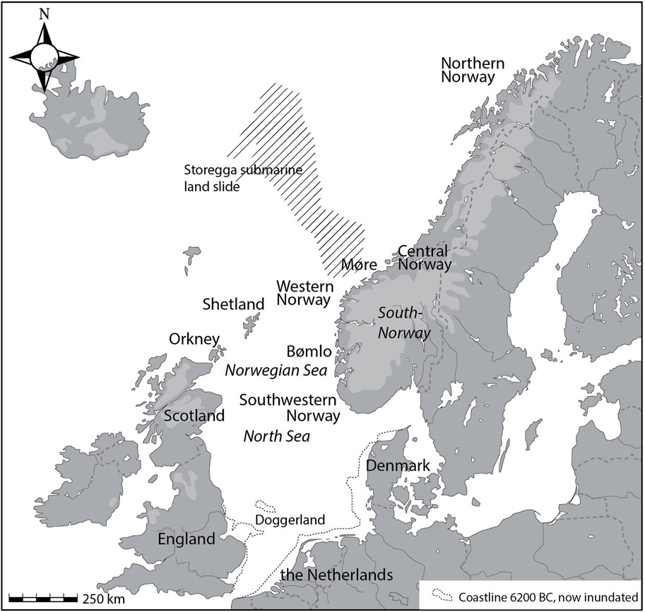
FIGURE 1. Map with names on regions and places mentioned in the text (Illustration: A.J. Nyland).
The size of the Storegga tsunami has led to it being commonly assumed as having been a disaster for the hunter-gatherer-fisher (Mesolithic) societies living on shores of Norway and the North Sea basin (e.g., Edwards 2004; Bjerck 2008; Waddington 2014; Waddington and Wicks 2017). While the tsunami itself has been well evidenced, the effects it had upon coastal Mesolithic communities have been less systematically explored. To add to the challenge, the tsunami appears to have struck at the coldest period of a climatic downturn associated with this stage of the Holocene, the 8.2 ka climatic downturn (Bondevik et al., 2012), making it challenging to differentiate the impact of these two events. To date, most assessments have had to infer cultural effects from primarily environmental data, or utilise large-scale palaeodemographic modelling to summarise trends that amalgamate rather than differentiate the 8.2 and Storegga events (Wicks and Mithen 2014; Waddington and Wicks 2017; Mithen and Wicks 2021). In this paper, we attempt to give a broad overview of the cultural data to hand, presenting a regional assessment of the Mesolithic record broadly contemporaneous with Storegga tsunami from western Norway, Northeast UK, and the southern North Sea basin. The period in question spans between 7,500–5,000 BC, with the tsunami placed at around 6200 BC (8,150 cal BP). Based on recorded sites, we know that Mesolithic people in Norway, Scotland, and northern UK, were coastal dwellers, living on shores of islands and headlands, or along resource-rich tidal currents, but what archaeological material is there to indicate how people were affected by the tsunami?
Climate change, tsunami-disasters, and other natural hazards leading to societal disruption and devastation have increasingly come into focus the last 25 years in anthropology (e.g., Oliver-Smith 1996; Oliver-Smith and Hoffman 1999; Barrios 2016; 2017), and archaeology (e.g., Grattan and Torrence 2002; Riede 2014; Egan and Sheets 2018; Riede and Sheets, 2020). Increasingly, it has also been acknowledged that “Hazards […], can no longer be thought to have a purely “natural” ontology; rather, the human and social now reside within them” (Barrios 2017, 156). Nevertheless, our review demonstrates how the identification of the Storegga tsunami impact has primarily been reliant upon natural markers and top-down analyses of cumulative-data, and because of this, there are gaps in our knowledge. We still don’t understand the tsunami’s social impact, even at a local level, for the Mesolithic coastal communities who lived through it. However, as our review will show, the material that can enable such studies is growing. How do we investigate prehistoric impact if we cannot find direct evidence of “squashed Mesolithic people” (Wickham-Jones 2002)? Perhaps a better approach would be to use the Storegga tsunami as a point of departure from which to discuss the ways in which prehistoric communities may have withstood or recovered from a catastrophic event.
Evidence of the Storegga Tsunami; a Regional Overview
Evidence of the Storegga tsunami was first recognized in the 1980s, and in the years that have followed, a number of research papers have identified deposits relating to the tsunami (e.g., Svendsen and Mangerud 1987; Dawson et al., 1988; Bondevik et al., 1997; Bondevik et al., 1998; S. Dawson and Smith 2000; Selvik, 2001; Bondevik et al., 2005; Prøsch-Danielsen 2006) (Figure 2). These works bear testament to the magnitude of the tsunami, on the coasts of western Norway and the northern UK. During the 1990s, awareness of this event slowly became apparent in the archaeological literature too. For example, a potential tsunami deposit at the Mesolithic site of Castle Street, Inverness, had been reported, but due to the timing of the discovery, had not initially been connected to the Storegga event (Wordsworth et al., 1986; Dawson, Smith et al., 1990). This was later reinterpreted as a tsunami deposit by geographers who were already familiar with the phenomenon (Dawson et al., 1990). In Norway, the tsunami was also starting to be discussed as a potential depositional agent in site reports in the 1990s (e.g., the site Leira, see Johansen and Sandvik 1995; Lok1 Sætergården, see Simpson 1998).
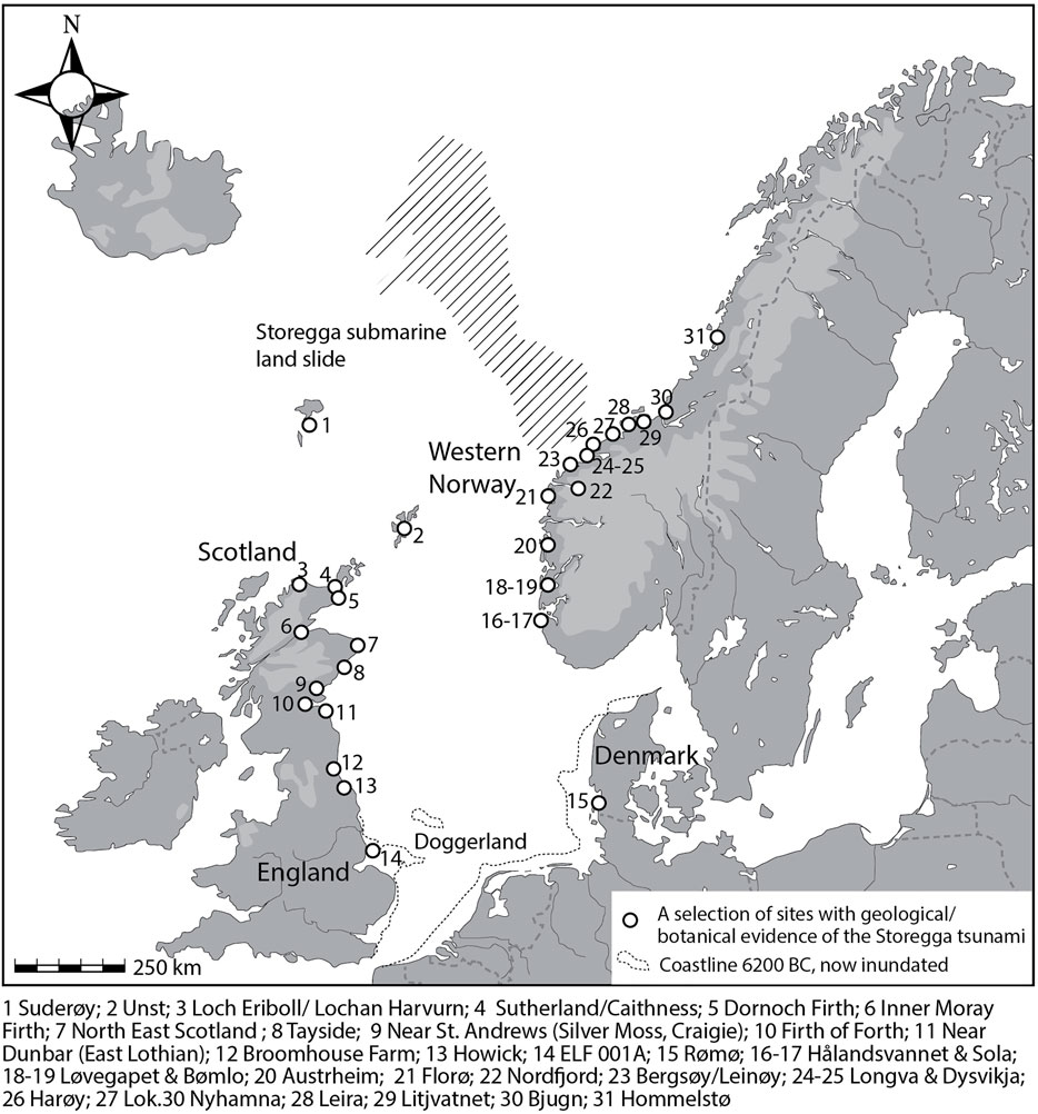
FIGURE 2. Map with sites where Storegga tsunami deposits have been geologically and botanically identified. Information is compiled from published papers, book chapters and reports, as well as unpublished (archival) excavation reports].
The Norwegian coastline presents a “topographic, bathymetric, and environmental mosaic”, to quote Blankholm (2018), and the complexity of this mosaic only increases when expanded to include the surrounding of the North Sea basin for consideration. This complexity, alongside differences in national research traditions, as well as, of course, genuine archaeological variability, affects the number, preservation, and location of archaeological sites across different regions. Hence, West Norway, the UK, and the Mesolithic southern North Sea perimeter, hold different ‘archives’ and archive potential for studying the impact of the tsunami.
Western Norway
In western Norway, the Middle (ca. 8,000–6000 BC) and Late Mesolithic (ca. 6000–4000 BC) population had a pronouncedly coastal orientation, living at the shores, exploiting islands, islets, headlands, bays, and along tidal currents (e.g., A.B. Olsen 1992; Bergsvik 1994; Nærøy 1994; Bergsvik 2002a; Bjerck 2008; Bjerck et al., 2008; Skjelstad 2011; Bergsvik et al., 2020). As acidic soils have broken down most organic materials, dating of sites is often aided by sea-level variation, a method that has long been integrated in Norwegian Stone Age archaeology (Fægri 1944; Kleppe 1985). Lately, sea-level curve adjusted site heights and C14 dates have begun being compiled (e.g., Bjerck et al., 2008), as recent development led archaeological excavations have increased the number of radiocarbon dated sites before/after the tsunami. Moreover, the increase in number of well excavated and dated sites gives new possibilities to investigate variation or continuity in mobility patterns, settlements, lithic technology, etc. (Figure 3, Supplementary Table S2).
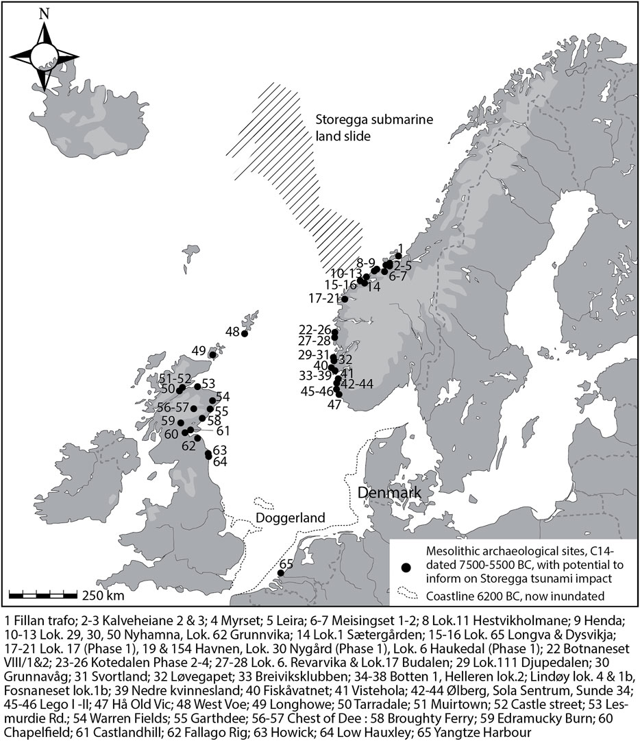
FIGURE 3. Overview of sites that have the potential to demonstrate impact of the Storegga tsunami on a regional level. The list is not exhaustive, but it gives an overview of primarily coastal Mesolithic sites that are C14 dated to around the period that the tsunami hit. Information is compiled from published papers, book chapters and reports, as well as unpublished (archival) excavation reports listed in Supplementary Table S1, S2.
With some regional exceptions, most recorded Mesolithic sites in Norway are currently on dry land, their location range in general somewhere between 7–20 m. a.s.l. However, due to a period of marine transgression in the second half of the Middle Mesolithic, sites became covered by beach deposits (see Nyland 2020 for examples of varying sea level curves). This Tapes-transgression reached its maximum during the Late Mesolithic (Fjeldskår and Bondevik 2020). Depending on the exposure to, and level of wave energy, the preservation status of sites and material found below transgressed beach sediments varies (e.g. Bjerck et al., 2008; Skjelstad 2011; Åstveit, 2016). Finds can be severely water rolled, enmeshed in clay or gravel, or, if the transgression was sheltered and slow, pristine and sealed. Nevertheless, the covering and potential disturbance of Middle Mesolithic sites are elements that needs to be considered when how representative the sample of sites from the time around the Storegga tsunami is. Still, the Tapes-transgression notwithstanding, there is a good number of Middle/Late Mesolithic sites that enable studies of life before and after the Storegga tsunami. Thus, we will mention some key sites in three distinct areas along the west coast and representing the kind of sites one can study along the Norwegian sites (but see Figure 3 and Supplementary Table S1 for an overview of radiocarbon dated sites from before and after the tsunami).
As stated, there are sites that are clearly transgressed and disturbed after occupation by the tapes transgression. For example, at the Fosen peninsula at Karmøy, Rogaland County, five sites were dated to the Middle and Late Mesolithic (Skjelstad 2011). One of these sites, Botten 1, one layer was dated to the Middle Mesolithic, 6,830–6,650 cal BC (7,900 ± 40 uncal BP, Beta-1973313); under a layer of gravel and sand, there was a clay layer with pristine finds. The finds were intact, perhaps because the site had been located in a sheltered bay, still, its site distribution and cultural layers were disturbed (Olsen 2011). There was charcoal dated to 6,370–6,230 cal BC in the layer too (7,420 ± 50 uncal BP, Beta-198763), that is, from a time the site was already transgressed. Hence, the situation indicates a disturbance, but whether it was caused by the Storegga tsunami, remains up for debate.
Other sites, such as one on, and under a raised beach at Løvegapet, Bømlo in Hordaland, are also clearly disturbed by the transgression as seen in water-rolled lithics (Åstveit, 2016). However, here, the gravel and sand also sealed layers which give opportunities for dating continual phases of activity at one and the same site (ibid.). Moreover, in the immediate vicinity of the Mesolithic activity, the raised beach has also sealed a 20 cm thick sandy layer which is interpreted as a Storegga deposit (Åstveit, 2016). Another site with persistent habitation is Kotedalen, located further north, on the side of a strong tidal current in Hordaland. The site was excavated in the late 1980s (Olsen 1992) and extensive zoo-osteological, botanical macro- and micro-fossil analyses were undertaken (Hjelle, 1992). A cultural layer with a total of 16 Stone Age phases was identified, where Phases 2–6 date from 6,560 to 5,580 cal BC (approx. 7610–6800 uncal BP), i.e., immediately spanning the Storegga event (Olsen 1992, 266) (see also Supplementary Table S2). Other sites with cultural layers dating to before and after the event include Nyhamna, Aukra, Møre og Romsdal. In 2003-2004, a total number of 28 sites located in immediate proximity to each other were excavated (Bjerck et al., 2008). Compared to Kotedalen, less organic material was preserved, but thick cultural layers provided the possibilities for extensive radiocarbon dating, as well as botanical analyses of macro fossils and pollen. From the project as a whole, there are 287 radiocarbon dates, including AMS and conventional dates (Bjerck et al., 2008, 79). At least four sites of varying size, content, organization and in different condition are dated to the period before and after the tsunami event (see Supplementary Table S2). In a trench through a wetland area, a sediment trap between two of the sites (Sites 29 and 30) dated to the Middle and Late Mesolithic, a layer consisting of unsorted material, sand, gravel, stones was dated and interpreted based on two dates: 6,380–6,220 cal BC and 6,375–6,220 cal BC, and heterogeneous composition as a tsunami deposit (Bjerck et al., 2008, 126–127). The same layer was not documented on top of the cultural layers at Sites 29 and 30, which again opens the question as to how to directly identify the impact of the Storegga event archaeologically.
In general, pertaining the Norwegian evidence, despite the comparatively large scale of recent archaeological investigations, there are not many sites where impacts of the Storegga tsunami have been directly documented, beyond layers in nearby wetland areas. Nevertheless, the recent extensive development led archaeological excavations of Mesolithic sites has greatly improved the number of sites where one can investigate persisting traditions in settlement and lithics production. There are more, and better radiocarbon dated sites and layers. The thick cultural layers at some sites indicate a tradition for reoccupation of the same place over time, of persistence of maritime traditions or site location preferences throughout the Mesolithic. The mentioned examples are from different parts of the west coast of South Norway, which the tsunami hit with varying force. We must thus assume that the impact, as well as experience would have led to varying responses. There is material to discuss, but the challenge is perhaps to securely relate it to tsunami impact.
Eastern Scotland and Northeast England
The potential human impacts of the Storegga tsunami in Eastern Scotland have been identified through a small number of claimed associations between archaeological deposits and tsunami deposits and overall models of changing activity (Figure 3, Supplementary Table S1). The Mesolithic of Eastern Scotland is poorly resolved chronologically, and the tsunami falls with the Later Mesolithic as traditionally and typologically defined (ca. 8,000–4,000 BC)—a period too broad to be of much analytical value. Numerous surface collections indicate the importance of coastal landscapes, as well as inland areas, but are not suitably chronologically resolved to contribute meaningfully to debate, so the discussion here is limited to reliably radiocarbon dated sites dating to ca. 7,500–5,000 cal BC, and with a primary focus on those located near the coast. The shell middens at Morton (Coles 1971) have long held a position of prominence in discussions of the Mesolithic in East Scotland, and appear to have been sites of occupation for some time, but issues with the reliability of dating at these sites (Warren 2015) renders it difficult to integrate them into considerations of the tsunami event. It is important to stress that the quantity of data available in Scotland is much smaller than Western Norway.
Broadly speaking, the tsunami falls into a period when evidence of hunter-gatherer activity includes pits, middens, and occupation soils. Structural evidence is rare. The younger of two post circles at Lesmurdie Road is dated to ca. 6,200 cal BC. These poorly understood features may be large houses, but are not associated with any artefacts (Suddaby 2007). A small tent has been identified at Caochanan Ruadha, >500 m above sea level in the Cairngorm mountains and was occupied at ca. 6,200–6,050 cal BC (Warren et al., 2018). The site is at least 70 km as the crow flies from the coast.
Pits, some with artefacts and some without, are known from before, contemporary with, and after the tsunami and are found in coastal and inland, upland locations. The latter include two datings to 6200 cal BC and without any artefacts at 450 m msl, at Fallago Rig, in the Lammermuirs, about 20–25 km from the sea as the crow flies. A pit on a prominent moraine at 630 m msl at Edramucky Burn, Ben Lawers, dates to c. 7,200–6,700 cal BC and is at least 80 km from the coast (Atkinson 2016). An alignment of 12 pits at Warren Field, inland on the River Dee and dating to the early eighth and seventh Millenia is sometimes claimed to have astronomical alignment (Murray et al., 2009; Gaffney et al., 2013). Inland, at Chest of Dee in the Cairngorms, occupation soils, fire settings and pits have all been identified showing long-term, but discontinuous use of a persistent place, with key episodes of activity at 7,000–6,500, 6,200–6,000 and 5,500–5,000 cal BC (Wickham-Jones et al., 2020).
Some coastal locations for activities including the use of pits appear to have been used prior to and after the tsunami. At Chapelfield, in Cowie, for example, located at the edge of the carse clays at Stirling, Mesolithic activity included the deposition of carbonized material in pits between the early seventh millennium and the mid-fifth millennium BC (but not continuously). Deposition in pits at this location continued into the Neolithic (Atkinson 2002). Excavations at Castlandhill on the north shores of the Firth of Forth found an oval, pit-defined (?) structure c.4.7 × 3 m in size (Robertson et al., 2013). Later Mesolithic artefacts were found in post holes, but with no material suitable for radiocarbon dating. A scatter of pits near the structure with two distinct clusters includes examples dating to 6,800–6,600 cal BC and 5,300–5,050 cal BC, with more pits a little further away dating to 4,900–4,700 cal BC. Another pit, again with no artefacts but in this instance sealed with a carefully placed stone layer was found above the River Dee a short distance from the coast at Garthdee, and dates to ca. 5,500 cal BC (Murray et al., 2014). At a very broad scale, this seems to imply some continuity in practice before and after the tsunami.
Middens in the Beauly Firth include examples at Tarradale which are found on both the 17 and 9 m.a.s.l raised beaches with dates on the former ranging from 6,500 to 6,000 cal BC. Middens have been observed in Inverness, but are poorly understood, and another example at Muirtown (Myers and Gourlay 1992) is mid fifth millennium in date. A single radiocarbon date on charcoal from the “lower oyster midden” at West Voe, Shetland is c. 6800 cal BC (Edwards et al., 2009; Ballin 2011), but almost all of the other dated activity on site is very late fifth or even fourth millennium.
Occupation soils are also known, and some are claimed to have associations with tsunami deposits. At Castle Street, Inverness, an occupation soil contains lithics and charcoal (Wordsworth et al., 1986). Two bulk charcoal dates from the occupation soil lie in the mid seventh millennium cal BC1. The occupation deposits are claimed to be truncated by Storegga tsunami deposits (Dawson et al., 1990). It is not possible to assess how much time elapsed between the occupation and the tsunami deposits, nor if this location was a long-term focus of settlement. Post-tsunami the site is characterised by beach sand not a forest soil, so there appears to be local environmental change which may have been caused by the tsunami or other longer-term processes of change.
Late 19th century excavations at Broughty Ferry (Hutcheson 1886) are sometimes claimed to show a relationship between tsunami deposits and Mesolithic activity (Dawson et al., 1990). The initial report identified a “black band with flints and rounded stones” sealed by an approximately 60 cm sand deposit. Although the artefacts are now lost, Lacaille considered them to be Mesolithic, and described the overlying deposit as an “exceptional tide which disturbed the refuse of occupation” but it is not clear what the basis is for this claim (Lacaille 1954, 177). Given the lack of modern excavation or stratigraphic interrogation control and techniques, the scant recording of information from this pre-1900s investigation and lack of any associated dating evidence means that caution is needed in interpretation (Lacaille 1954, 177). Finally, truncated occupation deposits in bedrock hollows were also identified at Longhowe, Orkney. These deposits survived when the ground surface was stripped to construct a barrow: they include microliths and other lithics and hazelnuts dating to 6,820–6,660 cal BC (https://canmore.org.uk/site/91743/langskaill). The site was not coastal at time of occupation.
Glacio-isostatic adjustment models indicate that only the northernmost stretch of the northeast England coast is liable to bear evidence for Storegga tsunami deposits. At Broomhouse Farmhouse, a Storegga deposit was recorded at approximately 2.45–2.80 m above sea level (Shennan et al., 2000), and another was recorded 28 km further south at Howick Burn, 3.10–3.55 m beneath sea level (Boomer et al., 2007, 101). Various Mesolithic materials have been found from around Budle Bay, the Bamburgh headland, and the island of Lindisfarne (Young and O’sullivan 1993; Young 2007), close to Broomhouse Farmhouse, but many of these are undated findspots, or poorly recorded excavations from the early 20th Century, and many would have been less coastally oriented 8,200 years ago than they are today (Young 2007, 22; Bicket et al., 2016).
Further south, recent work led by Clive Waddington and others at the sites of Howick and Low Hauxley have improved our knowledge of the Mesolithic in the northeast of England (Waddington 2007; Waddington and Bonsall 2016). However, both these sites appear to have been abandoned some thousand years prior to the Storegga tsunami (Waddington and Wicks 2017). Only Low Hauxley has Mesolithic evidence from afterwards, but this is limited a single shell midden date of 6170–5,790 cal BC (Hamilton-Dyer et al., 2016), and two dates of over a thousand years later (Waddington, 2016, 53), with insufficient associated archaeological materials from which to infer the nature of human activity at the site from this time.
The Southern North Sea Basin
The Storegga tsunami has previously been theorized as having brought about a swift and catastrophic end to Doggerland, the submerged palaeolandscape of the southern North Sea (Weninger et al., 2008). However, a more nuanced understanding is beginning to emerge in the wake of numerical modelling of the wave’s dispersal (Hill et al., 2014; Hill et al., 2017), and the discovery of the first confirmed evidence of the tsunami from a submarine context, “core ELF001A” from the “Southern River” submerged river valley, recovered by the Europe’s Lost Frontiers team (Gaffney et al., 2020). Clearly the Storegga tsunami hit some of the coastlines of the southern North Sea with considerable force, but the severity of this impact was probably variable (Walker et al., 2020).
Rapid sea-level rise around this period means that reconstructing contemporary submerged coastlines is difficult (Cohen et al., 2017), but much of Doggerland appears to have become submerged prior to the tsunami (Walker et al., 2020). This includes much of what is now the Dogger Bank (Emery et al., 2019; Hijma and Cohen 2019), which may have only been partly subaerial–a saltmarsh peat horizon, prior to final inundation, has been dated to 8,140 ± 50 BP (Shennan et al., 2000, 303). The shallow palaeobathymetry of this newly submerged topography may have had a significant effect on the wave energy dispersion of the tsunami, concentrating it in some areas, and mitigating it in others. Contrary to earlier propositions, however, the tsunami would not have been the instigator of a permanent sea-level rise (Walker et al., 2020).
There is one stratified, submerged Mesolithic site from the southern North Sea that has been identified and investigated: the Yangtze Harbour site off the Dutch Coast, occupied discontinuously between 8,500 and 6,400 BC (Moree and Sier 2015). Sedimentary evidence of region-wide marine flooding in this area that might have been caused by the Storegga tsunami travelling up the Rhine-Meuse estuary (Peeters, 2015). Several terrestrial Mesolithic sites are known from nearby dune and reclaimed polder landscapes, but evidence of Storegga from this far south remains unconfirmed.
Evidence of the Storegga tsunami in Denmark has been found from a submerged context at Rømø, in Denmark (Fruergaard et al., 2015), and may be present but unconfirmed elsewhere too (Noe-Nygaard, 2005). The projected run-up height at Rømø is between 1.5 and 5.5 m above contemporary sea-level and indicates that parts of the Atlantic Danish and German Bight coast may have been impacted by the tsunami (Chacón-Barrantes et al., 2013; Fruergaard et al., 2015). Shorelines from 8,200 years ago in these areas are, however, now mostly submerged (Astrup 2018), and the relative lack of contemporary Mesolithic archaeology from near the current-day coasts in these areas (Sørensen et al., 2018, Figure 12.1), makes it difficult to infer the impact of the tsunami. In Denmark, the Kongemose period began around 6400 BC, and saw the introduction of some new technological types (Astrup 2018, 23–25), has been posited as a the beginning of a shift towards increased coastal resource exploitation, but this may be a bias in site visibility (Astrup 2020), and in many other respects the Kongemose appears as a continuation of the Maglemose (Blankholm 2008). Although recent progress has been made in finding proxies of the tsunami from around the Southern North Sea basin, there is extremely little archaeological data that can be related to the event. The only submerged and stratified Mesolithic site from this area just predates the event. Perhaps the discovery of further submerged sites or coastal sites in the future may hold potential, but at present the ability to gauge impact in this region is entirely incomparable to areas further north.
Discussion: The Social Impacts of the Storegga Tsunami?
Evidence of a Significant Natural Phenomenon, but Less of its Human Impact?
The extensive natural sciences research identifying where and when the Storegga tsunami hit provides a fantastic point of departure for discussions about how a punctuated event in prehistory potentially had a major impact on human lives. Geological deposits allow for estimates of run-up height, as does numerical modelling (e.g., Løvholt et al., 2005). Although the results of these estimates do not always favorably align (geological deposits provide minimum estimates) with one another (Dawson et al., 2020), they do both project that at least parts of the Norwegian and Scottish coastlines would have been struck by fearsomely large waves, with onshore run-up of 25 m or higher in some areas (Smith et al., 2004; Bateman et al., 2021). Indeed, in a recent survey of 145 tsunami deposits from around the Atlantic Ocean basin, 46% (n = 67) are attributed to the Storegga slide (Costa et al., 2021), making it the most widely documented tsunami event from the Atlantic. This begs the question then, what is needed archaeologically to identify disruption to historical contingency? As our overview indicates, between the presented geographic regions, there is great variation with regards to accessible archaeological knowledge from excavated Mesolithic sites falling within the time-frame of our study (Figure 3 and Supplementary Table S1).
While evidence for the tsunami is clearly attested throughout parts of the eastern Scottish and western Norwegian coastlines, evidence of impact relating to Mesolithic peoples remains much more equivocal. Finding evidence of the tsunami is one thing, but inferring its human impact is an altogether different proposition. The widespread distribution of Storegga deposits, including far afield in the Faroes, Iceland and even as far away as Greenland, combined with run-up heights in excess of 25 m recorded in parts of Scotland and Norway, all lend to a notion of a truly terrifying if not catastrophic event.
However, such an assumption without archaeological corollary is problematic. While there is clearly a relationship between the height of tsunami run-up, wave energy, and the potential with which it can devastate a landscape upon breaking, it is problematic to simplistically assume a tsunami’s intensity (much less human impact) as a function of magnitude (Papadopoulos and Imamura 2001). Clearly, topographic variability and relative positioning within the landscape are key factors in influencing the potential for human loss and destruction, and this can vary at a highly localised level–measurements of run-up height from the Okushiri tsunami along the Inaho Coast, Japan, show that run-up varied by as much as 4 m across a 3.5 km stretch of coastline (Yeh, Barbosa et al., 2015). Furthermore, while a diverse body of literature continues to develop around how to measure tsunami intensity (e.g.,Papadopoulos and Imamura 2001), these studies are almost exclusively concerned with recent or contemporary tsunami events, and consequently discuss impact relating to built environments rather than the radically different circumstances of a purely hunter-fisher-gatherer populated landscape.
Local topographic variability not only influences where and how badly hit an area within the landscape will be when struck by a tsunami, but it is also a factor in the formation and preservation of geological evidence. The variability of the Norwegian shore makes it difficult to generalise, but most instances of Storegga deposits here have been recorded in lake basins, as a result of the sharp incline of many parts of the western Norwegian coast. In contrast, in Scotland the tsunami has been most frequently recorded as a widespread sand layer within an estuarine mud, sometimes visible within exposed coastal sections (Wickham-Jones 2002; Bondevik 2019; Dawson, Dawson et al., 2020). Moreover, not every area affected by a tsunami, will necessarily leave an onshore archive (Dawson et al., 2020). To further complicate this, while tsunami coverage of a landscape might be widespread, archaeological evidence is restricted to where people were within the landscape, that might also survive subsequent taphonomic processes. Despite the geological documentation of tsunami layers in close proximity to archaeological sites as at Nyhamna (site 29 and 30) and Bømlo (Løvegapet), direct traces of impact at the occupation sites themselves were not identified. Additionally, locations that serve as sediment traps are not necessarily likely to have been attractive places for settlement, where dry, well-drained and flat surfaces may typically have been preferable. Lastly, of course, the destructive power of a tsunami is such that in the event of a highly destructive wave, we might envisage a scenario whereby such a tsunami might destroy contemporary settlements, but also recently formed archaeological deposits. Such a scenario has been hypothesised by Clive Waddington and Karen Wicks for their study of northern Britain (2017).
Limitations of Traditional Archaeological Approaches: or How to Identify Squashed Mesolithic People!
At an individual level, site stratigraphies may be interpreted relative to the event, but any assessment of societal-level impact requires consideration of multiple sites. So far, this has only been undertaken on materials from the northeast UK, and from this it was determined that changes in lithic technology and site recognition could not be invoked as an explanation of population decline–the theory advanced in light of demography modelling (Waddington and Wicks 2017, 708).
From our review, it is clear that some sites have unequivocally continuous records of occupation spanning the tsunami. Yet, the destructive nature of the tsunami might also mean that we are less likely to find places where evidence of the tsunami and Mesolithic archaeology co-occur. As stated above, tsunami deposits that contain archaeological materials are, globally, rarely encountered. As we see it, perceptions of the human impact of the Storegga tsunami have, to date, typically followed one of two lines of enquiry: either 1) inferring impact, sometimes implicitly, from the now sizeable database of geological deposits pertaining to the event from around the Scottish and Norwegian coasts relating to the event; or 2) identifying trends in palaeodemographic models of C14 dates that might relate to these changes.
The first line of enquiry is problematic as it can, without recourse to accompanying archaeological data, effectively reduce Mesolithic people to passive bystanders, with a normative assumption of vulnerability. Alternatively, one has to concede that the range of possible caveats that might exempt a group from wipeout, as simple as positioning within the broader landscape at the time of the event, is too great to exclude (see Blankholm 2018). With regards to the second line of enquiry, hiatus and continuity in stratigraphic layers can be indicative of a number of causal factors. Demographic modelling of population levels throughout different periods of prehistory has enjoyed recent popularity, and several studies have suggested that the 8.2 event may have been exacerbated by the Storegga tsunami (Wicks and Mithen 2014; Waddington and Wicks 2017) (but see Weninger et al., 2008; Blankholm 2018, for different approaches). Identified troughs in the generated curves representing demography during the Mesolithic are interpreted as signalling population decline (see also Solheim and Persson 2018; Damm et al., 2019; Bergsvik et al., 2021; Mithen and Wicks 2021). Other such studies, however, have either found the effects of both these events to be less obviously related to any apparent changes in demography, or less confident in their attribution of significance (Griffiths and Robinson 2018; Maldegem et al., 2021). If nothing else, these approaches clearly highlight the variable effects that changing the study area and data included can have on the conclusion that is reached. Moreover, if the regions, and indeed local areas experienced differential impact from the tsunami, then regional top-down approaches might be better combined with bottom-up, local comparative studies.
Examples of this second approach, stratigraphic discontinuity combined with C14 dating have been used to indicate mobility and settlement at archaeological sites from northern Vancouver coast (British Columbia, Canada) to Oregon (California, and northern Washington, US) where such patterns coincided with earthquake/tsunami activity (inferred tsunami deposits) over a period of 3,000 years (Hutchinson and Mcmillan 1997). Hiatus and discontinuity in occupation must be considered in terms of causal factors–what, if any, are the archaeological signatures we might look for that indicate devastation from a tsunami other than a drop in the number of sites, and how precipitous should such a drop be in order to qualify as compelling evidence of a disaster?
The question of archaeological proxies of impact relates in part to a theorised approach outlined by Goff et al. (2012) which seeks to establish five archaeological proxies of a devastating tsunami event: 1) changes in midden composition, 2) evidence of structural damage, 3) geomorphological change, 4) reworking of anthropogenic deposits and 5) the replication of these findings across multiple sites. So far, however, such an approach has not been systematically applied to considerations of Storegga, and with the aforementioned limitations of the archaeological data, it is not clear to what extent such an approach might yield informative results. Some observed changes in material culture have, for example, been linked to destabilisation as the result of tsunamis and other extreme natural forces in the archaeology of Maori coastal settlements in New Zealand (Mcfadgen 2007).
To further compound the difficulties of understanding the impact of an event such as the Storegga tsunami, we must also attempt to disentangle the consequences of this from the background effects of the 8.2 ka cold event, which was seemingly responsible for a significant and rapid rise in sea-level around the North Sea basin, and perhaps a drop in annual temperatures too. The 8.2 ka climate event lasted about 200 years and is recognized globally. In the regions discussed this paper it would have been experienced as a drop in summer and winter temperatures, fiercer storms and generally more unruly weather (Dawson, Bondevik et al., 2011). In recognising the impact that the 8.2 event might have had on Mesolithic communities, we might see the impact of the Storegga tsunami as a convergent impact (e.g.,Wicks and Mithen 2014; Waddington and Wicks 2017)). The nature of demographic modelling studies makes it difficult to disentangle the broadly synchronous 8.2 cold event and Storegga tsunami events. It is hard to say whether the impacts of these events were convergent, or simply appear as conflated. However, establishing unequivocal evidence of impact relating explicitly to one event or the other is a broader problem for archaeology as a whole.
A final factor to consider, as mentioned earlier, is that tsunamis are an inherently destructive force, and the erosive action of such an event may have removed any recently deposited archaeology in addition to extant settlement (Waddington and Wicks 2017; Mithen and Wicks 2021). The population decline identified in Waddington and Wicks’s study began at 6600 BC, several hundred years prior to the 8.2 and Storegga events, with a population rebound centred around 6000 BC. The tsunami may, they argue, have created a taphonomic effect “that has reduced the number of surviving/detectable sites for the centuries prior to the Storegga megaslide event.” (Waddington and Wicks 2017, 708) which might explain the misalign in dates. From this they hypothesise a population reduction, and a relocation of the existing population into higher ground, away from the coast–a pattern of aversion in the wake of a disastrous event. The proposed taphonomic filter is an important suggestion but at present requires further substantiation.
Shared Event, yet Distinct Mesolithic Histories of Vulnerability and Resilience
The regional variations between the areas discussed above are partly determined by the geological histories of these respective areas, and the differential effects of glacio-isostatic adjustment and variations in the history of archaeological research. In Norway, parts of the coastline have been uplifted since the time of the tsunami, while other areas have remained comparably stable, or become submerged. Complicating this, some of the Norwegian coastlines that were struck by the tsunami have been subsequently transgressed prior to becoming subaerial again (Bondevik 2003). Although, distinct sediment composition allows for differentiation of these deposits in many cases (Bondevik et al., 1998). A large quantity of Mesolithic sites, many excavated recently in advance of development, date to the period of interest.
In Scotland, the sea-level would have been higher than it is at present for some parts of the coast, meaning the coastline contemporary with Storegga is still extant in some places, and perhaps not always far-out to sea in areas where it is submerged (Sturt et al., 2013; Smith et al., 2004: 2315). Eastern Scottish Mesolithic sites are also found on and close to the current coastline, and although some of these areas would have been coastal in the Mesolithic, in some places the coastline of 8,200 years ago is submerged, as in the case of Orkney (Wickham-Jones, 2002). Also challenging for all these regions, is distinguishing between tsunami deposits and storm surges (Bondevik et al., 2019). The available data for Scotland and northern England is much more limited in scope than from Norway.
The Boreal coastlines of southeast Britain, and Doggerland are not only submerged, but also in many places, located some distance from the current shoreline. Consequently, it is not unreasonable to expect that many of the areas impacted worst by the tsunami might be now be underwater (Bondevik et al., 1998; Bondevik et al., 2019). The same is true of parts of the former Danish coast. In Denmark, evidence for habitation of coastal zones is clear from the later Mesolithic, but less apparent prior to 8000 BP. Recent work by Peter Moe Astrup is beginning to challenge this picture, showing that at least some Maglemose sites were located in close proximity to coastal habitats and marine resources (2018; 2020).
Contact between the mentioned regions throughout the Mesolithic, including during and after 8,200 years ago, remains an ongoing question. There is archaeological evidence of long-distance mobility from the northeast to the southwest within Scandinavia at the start of the Middle Mesolithic (e.g.,Sørensen, Rankama et al., 2013; Damlien 2016). The recolonisation of the northern frontiers of the Britain during the Late Glacial must have involved populations traveling either up through the British mainland or alternatively, perhaps using Doggerland or Scandinavia as a point of departure, presumably following now submerged coastlines (see Stephen Mithen et al., 2015; Ballin and Bjerck 2016 for discussion). Evidence for this, and the extent to which connections across the North Sea were maintained and continued, however, remain unclear, with the cultural histories of Scotland and Norway throughout the Mesolithic appearing more divergent than similar in most respects.
Doggerland, which would have been an important Mesolithic landscape in its own right, would have facilitated connection between the Britain and northwest Europe until around 7500BC, when the rising sea-levels separated the two (Walker, In Press). As a result of this, it is typically assumed that any connections that might have existed between Mesolithic groups at this time would have at least begun to fragment by the time of the Storegga tsunami. Clear similarities between the Late Mesolithic records of lowland Europe and southern Scandinavia/northern Germany suggest contact if not some degree of cultural continuity. Around the southern North Sea basin on the continental mainland, clear similarities between the Late Mesolithic records of lowland Europe and southern Scandinavia/northern Germany suggest contact if not some degree of cultural continuity. The British Mesolithic shows some signs of divergence archaeologically, traditionally seen as lacking trapezoid microliths (although see Warren 2015), but it is unlikely that contact with communities across the water ceased entirely (e.g., Anderson-Whymark et al., 2015; Elliott 2015; Elliott et al., 2020; Momber et al., 2021). While it is not clear that there was not contact across extended distances over land and water between these regions when the Storegga tsunami hit, it does at least appear that different regional traditions had become established with regards to technology, raw material exploitation, landscape utilization and sites. With the Mesolithic populations of these different regions linked, if by nothing else, then by their relationship to the sea, we have good potential for a comparative study with regards to differential impact and responses to the tsunami by different communities of Mesolithic hunter-gatherer-fishers.
It is understandable that there is an inclination among many to characterize the tsunami as having been a disaster or catastrophic event (Bjerck 2008, 68; Weninger et al., 2008) and as Clive Waddington and Karen Wicks (2017, 695) have observed, it is difficult to believe that such an event would not have resulted in at least some loss of life, if not also settlements and resource bases which may have had a further destabilizing effect. The effects of this narrative are most apparent, and indeed perpetuated and compounded through repetition, in much of the media coverage of research into the event2. The Storegga event does appear to have been larger than any other Holocene tsunami to have struck the North Sea basin, and tsunamis are often associated with tragic human loss, with several examples from recent decades (perhaps most notably the 2004 Indian Ocean, and 2011 Tōhoku tsunamis) reinforcing this concern (Walker et al., 2020). The idea that this must have been a disaster has been encouraged by notions that hunter-gatherers are inherently vulnerable (Bettinger et al., 2015 [2001], 12), and that tsunamis can strike with little in the way of advanced warning (Edwards 2004, 67). In addition to this, the sheer scale of the tsunami, coupled with dramatized accounts of similar but non-analogous events (e.g., the 2015 Norwegian disaster movie Bølgen [The Wave], which shows a tsunami originating from within a fjord system in Møre og Romsdal County), and historical recollections of personal devastation (the Tafjord tsunami, which resulted in 40 deaths, and incidentally provided inspiration for the Bølgen movie), help further intuit the assumption that the Storegga tsunami must have been a disaster. The nature and extent of the tsunami’s impact and the damage it wrought is up for debate, but it is easy to imagine that, for those who lost loved ones at least, that such an event may have been conceptualized in such a way, even if just at a very personal level.
Despite the readiness with which archaeologists have come to regard the Storegga tsunami as a catastrophic event, however, there remain very few archaeological sites with direct evidence of tsunami deposits, and little apparent evidence of impact in the contemporary archaeological record. Consequently, it is difficult to gauge what the impact of the tsunami was without making bold assumptions about the impact of the wave, and the vulnerability of the people who lived through it. People and settlements would have been affected across these regions, but regionally variable geology, topography (both onshore and bathymetric), and palaeoecology, may all factor in creating different possibilities for physical and hence social impact. To these variables, we may add taphonomy, visibility and accessibility as further compounding factors when it comes to preserving, finding, and recognising archaeological evidence. The general lack of archaeological sites with direct evidence of the Storegga tsunami has led to geological data or other proxies being utilized as indicators of impact. However, these data do not alone tell us much about human impact, nor to the extent to which this event was a disaster for the coastal communities. Do we need to identify tsunami deposits at archaeological sites to understand its impact, or even claim that the tsunami had an impact?
Concluding Remarks
Investigations of these relatively autonomous regions can then provide good opportunity to gain insight into different developments of groups of people living under relatively similar conditions. If we acknowledge that hunter-gatherer groups may “comprise a spectrum of possible human lifeways” (Warren 2021, 807), we should expect a multitude of responses. Moreover, there is not one correct answer to the question of whether the Storegga tsunami was a disaster. To some, the tsunami would certainly have been deadly and disastrous, yet for others, it was perhaps only a reminder of the hazards of living by the sea. The challenge is then threefold, 1) to find evidence of how communities organised, 2) the disentangling from the 8.2ka climatic cold event, and 3) recognize whether the chosen organisation or social structures or mechanisms made the groups strong facing disasters, or vulnerable?
In order to identify the social impact of the Storegga tsunami, a wide range of approaches are needed. As the coastal Mesolithic population on both sides of the North Sea were dependent on coastal, intertidal, and riverine resources, a tsunami’s eroding powers, choking or depleting ecosystems even temporarily, might have had a massive impact on societal economy and subsistence (e.g., Dawson et al., 1990), influencing human-environment relations. Unfortunately, sites with preserved organic material are few, but there is also only so much we can read out of the geological and palaeobotanical records. Indeed, geological and botanical data needs to be contextualised and interpreted relationally to inform on social aspects, potentially shifting group dynamics, power balance, social networks etc. The Storegga tsunami may have led to a noticeable disruption of the historical contingency, which in turn may have opened, or forced societies to change, either intensifying or initiating new practices or traditions, or made societies reorientate their social networks. Alternatively, these societies were robust, or sufficiently flexible for life to soon return to the status quo. The regional overview of the quality or detailed knowledge of period specific archaeology also illustrates variability in the archaeological material from which we may hope to garner such inferences. This is a constraining factor on the type of studies possible in the different the regions.
Nevertheless, alternative prospects for inferring evidence of human, or social impact from the extant archaeology might focus on regional variation in lithic materials. Analyses of assemblages might highlight potential discontinuity in knowledge transmission and technology, which in turn may reflect changing expressions of social identity. Another option is to study site distribution patterns. Changes in preferred location of sites may reflect different types of mobility, or an increase or decrease in sedentism (Bjerck 1989; Bergsvik 2001, 2002b; Maldegem et al., 2021). Such approach has previously proved fruitful, like at the Kuril island close to Japan where a change in settlement pattern was detected after tsunamis had hit the coast in the Holocene (Fitzhugh 2012). Moreover, learning from ethnoarchaeological data also has great potential for better understanding possible responses in the wake of the tsunami. Through these approaches, it may be possible to identify mechanisms for knowledge transmission and maintenance of or change in social networks. Such changes may be interpreted as the elements of what constitutes either a state of vulnerability or a capacity for resilience in the face of an extreme force of nature such as the Storegga tsunami.
Ultimately, the idea that coastal Mesolithic groups would succumb to colder weather and a giant wave, without corroboratory evidence from archaeological evidence, seems to build on a presumption that they were primarily vulnerable, or at least lacked strategies to reorganize and rebound when their environment was changing, or their society faced dramatic upheaval. There is thus an interpretative paradox to be aware of: why do we assume that hunter-gatherers were vulnerable? Especially when one of the most prominent explanatory models for change in Mesolithic research involves niche construction. Mesolithic hunter-gatherer-fishers have, in recent years, often been presented as highly adaptable, spontaneous, flexible and well equipped for reorientation and exploitation of a variety of niches in order to survive (Rowley-Conwy 2001; Layton and Rowley-Conwy 2013; Warren 2020). Of course, a sudden freak event may destabilise even the most well-adapted of populations, but such an assumption is still an appeal to external forces that disregards the human variable. An alternative reformulation of the problem might be to ask what makes a Mesolithic society vulnerable, or indeed resilient? Hazards and disasters may challenge social structures and organization, potentially bringing about systemic adaptation in order to stabilise or innovate viable lifeways (Oliver-Smith 1996). Emphasising the social and anthropological aspect of a tsunami, we may move beyond the environmental and physical identification of the Storegga tsunami. We know it happened, we know it must have impacted the coastal communities, but human societies have always dealt with crises and lived with natural hazards, so the challenge remains learning what happened to the Mesolithic societies living before, during, and after it. Combining anthropology, ethnography, with the existing archaeological material from the three regions above, it may be possible to discuss the tsunami event with greater nuance, moving beyond dichotomous scenarios; perhaps a period during which life, meaning and stories, for some, were radically affected or transformed Blankholm, 2008, Riede and Sheets, 2020.
Author Contributions
The different contributions of the three co-authors are as follows: AN designed the paper, has written the section about the Norwegian overview, and contributed to the introduction, background, discussion, and conclusion. JW has written the sections about Northeast England, Doggerland and Denmark has contributed to writing the introduction, background, discussion, and conclusion. AN and JW share first authorship. GW has written the section about Scotland, and contributed with input on the introduction, background, discussion, and conclusion. AN has drawn the figures.
Funding
The paper is funded by the Research Council of Norway, project 302858, and the Museum of Archaeology, University of Stavanger.
Conflict of Interest
The authors declare that the research was conducted in the absence of any commercial or financial relationships that could be construed as a potential conflict of interest.
Publisher’s Note
All claims expressed in this article are solely those of the authors and do not necessarily represent those of their affiliated organizations, or those of the publisher, the editors and the reviewers. Any product that may be evaluated in this article, or claim that may be made by its manufacturer, is not guaranteed or endorsed by the publisher.
Acknowledgments
The authors would like to acknowledge the invaluable and long-standing contribution of geologists and botanists to identify and date the Storegga tsunami.
Supplementary Material
The Supplementary Material for this article can be found online at: https://www.frontiersin.org/articles/10.3389/feart.2021.767460/full#supplementary-material
Footnotes
1Two bulk charcoal dates lie in the mid seventh millennium cal BC, but they are inverted, and one has a very large standard deviation.
2E.g. https://www.bbc.com/news/science-environment-27224243; http://www.bbc.com/earth/story/20160323-the-terrifying-tsunami-that-devastated-britain; https://www.dailymail.co.uk/sciencetech/article-9648613/Geology-Study-reveals-tidal-wave-demolished-379-MILES-Scotlands-coastline-8-200-years-ago.html
References
Anderson-Whymark, H., Garrow, D., and Sturt, F. (2015). Microliths and Maritime Mobility: a Continental European-Style Late Mesolithic Flint Assemblage From the Isles of Scilly. Antiquity. 89 (346), 954–971. doi:10.15184/aqy.2015.77
Astrup, P. M. (2018). Sea-Level Change in Mesolithic Southern Scandinavia. Long- and Short-Term Effects on Society and the Environment. Moesgaard: Moesgaard Museum and Jutland Archaeological Society.
Astrup, P. M. (2020). “The Role of Coastal Exploitation in the Maglemose Culture of Southern Scandinavia - Marginal or Dominant,” in Coastal Landscapes of the Mesolithic. Editor A. Schulke (Routledge), 27–43. doi:10.4324/9780203730942-3
Åstveit, L. I. (2016). “Arkeologiske Undersøkelser Ved Tjong-Løvegapet På Søre Bømlo. Gnr 44/Bnr 5, 34, Bømlo Kommune, Hordaland,” in Rapport Nr. 6 - 2016: Fornminneseksjonen, Universitetsmuseet I Bergen, Avdeling for Kulturhistorie.
Atkinson, D., and Walmsley, J. (2002). Editorial. Proc. Soc. Antiquaries Scotland. 30, 139. doi:10.1046/j.1468-3156.2002.00202.x-i4
Atkinson, J. A. (2016). Ben Lawers: An Archaeological Landscape in Time. Results from the Ben Lawers Historic Landscape Project, 1996–2005, in Scottish Archaeological Internet Reports 62 (Edinburgh: Society of Antiquaries of Scotland).
Ballin, T. B., and Bjerck, H. B. (2016). Lost and Found Twice: Discussion of an Early Post-Glacial Single-Edged Tanged Point From Brodgar on Orkney, Scotland. J. Lithic Stud. 3 (1), 31–50. doi:10.2218/jls.v3i1.1393
Ballin, T. (2011). “The Post Glacial Colonization of Shetland – Integration or Isolation? Evidence from Lithic and Stone Assemblages,” in Farming on the Edge: Cultural Landscapes of the North. Some Features of the Neolithic of Shetland. Short Papers from the Network Meeting in Lerwick, Shetland September 7th - 10th 2010. Editors D. L. Mahler, and C. Andersen (Copenhagen: National Museum of Denmark), 32–43.
Barrios, R. E. (2016). Resilience: A Commentary From the Vantage Point of Anthropology. Ann. Anthropological Pract. 40 (1), 28–38. doi:10.1111/napa.12085
Barrios, R. E. (2017). What Does Catastrophe Reveal for Whom? the Anthropology of Crises and Disasters at the Onset of the Anthropocene. Annu. Rev. Anthropol. 46, 151–166. doi:10.1146/annurev-anthro-102116-041635
Bateman, M. D., Kinnaird, T. C., Hill, J., Ashurst, R. A., Mohan, J., Bateman, R. B. I., et al. (2021). Detailing the Impact of the Storegga Tsunami at Montrose, Scotland. Boreas. 50, 1059–1078. doi:10.1111/bor.12532
Bergsvik, K. A. (1994). “Lokaliseringsanalyse På Kollsnes I Øygarden, Hordaland,” in Troll-prosjektet. Arkeologiske Undersøkelser På Kollsnes, Øygarden K., Hordaland, 1989-1992. Editor A. J. Nærøy (Bergen: Department of Archaeology, University of Bergen), 239–262.
Bergsvik, K. A. (2001). Sedentary and Mobile Hunter-Fishers in Stone Age Western Norway. Arctic Anthropol. 38 (1), 2–26.
Bergsvik, K. A. (2002a). Arkeologiske Undersøkelser Ved Skatestraumen. Bind I, Arkeologiske Avhandlinger Og Rapporter 7. Bergen: Museum of Bergen, University of Bergen.
Bergsvik, K. A. (2002b). Task Groups and Social Inequality in Early Neolithic Western Norway. Norwegian Archaeological Rev. 35 (1), 1–28. doi:10.1080/002936502760123095
Bergsvik, K. A., Åstveit, L. I., Zinsli, C., and Olsen, T. B. (2020). Faglig Program I Arkeologi for Universitetsmuseet I Bergen 2020–2025. Steinalder Til Og Med Mellomneolittisk Tid (9500–2350 f.Kr.), Vol. UBAS 11. Bergen: University of Bergen.
Bergsvik, K. A., Darmark, K., Hjelle, K. L., Aksdal, J., and Åstveit, L. I. (2021). Demographic Developments in Stone Age Coastal Western Norway by Proxy of Radiocarbon Dates, Stray Finds and Palynological Data. Quat. Sci. Rev. 259, 106898. doi:10.1016/j.quascirev.2021.106898
Bettinger, R. L., Garvey, R., and Tushingham, S. (2015). Hunter-gatherers. Archaeological and Evolutionary Theory. New York: Springer.
Bicket, A. R., Mellett, C. L., Tizzard, L., and Waddington, C. (2016). Exploring Holocene Palaeogeography in the 'White Ribbon': a Mesolithic Case Study From the Northumberland Coast. J. Quat. Sci. 32 (2), 311–328. doi:10.1002/jqs.2897
Bjerck, H. B., and Åstveit, L. I. (2008). in NTNU Vitenskapsmuseets Arkeologiske Undersøkelser Ormen Lange Nyhamna. Editor H. B. Bjerck (Tapir: Trondheim).
Bjerck, H. B. (1989). Forskningsstyrt Kulturminneforvaltning På Vega, Nordland. En Studie Av Steinaldermenneskenes Boplassmønstre Og Arkeologiske Letemetoder. Trondheim: DKNVS, Vitenskapsmuseet, Department of Archaeology.
Bjerck, H. B. (2008). “Norwegian Mesolithic Trends,” in Mesolithic Europe. Editors G. Bailey, and P. Spikins (Cambridge: Cambridge University Press), 60–106.
Blankholm, H. P. (2018). In the Wake of the Wake. An Investigation of the Impact of the Storegga Tsunami on the Human Settlement of Inner Varangerfjord, Northern Norway. Quat. Int. 549, 65–73. doi:10.1016/j.quaint.2018.05.050
Blankholm, H. P. (2008). “Southern Scandinavia,” in Mesolithic Europe. Editors G. Bailey, and P. Spikins (Cambridge: Cambridge University Press), 107–131.
Bondevik, S., Lødøen, T. K., Tøssebro, C., Årskog, H., Hjelle, K. L., and Mehl, I. K. (2019). Between Winter Storm Surges - Human Occupation on a Growing Mid-Holocene Transgression Maximum (Tapes) Beach Ridge at Longva, Western Norway. Quat. Sci. Rev. 215, 116–131. doi:10.1016/j.quascirev.2019.05.006
Bondevik, S., Mangerud, J., Dawson, S., Dawson, A., and Lohne, Ø. (2005). Evidence for Three North Sea Tsunamis at the Shetland Islands Between 8000 and 1500 Years Ago. Quat. Sci. Rev. 24, 1757–1775. doi:10.1016/j.quascirev.2004.10.018
Bondevik, S., Mangerud, J., Dawson, S., Dawson, A., and Lohne, Ø. (2003). Record-Breaking Height for 8000-Year-Old Tsunami in the North Atlantic. Eos Trans. AGU. 84 (31), 289–300. doi:10.1029/2003eo310001
Bondevik, S. (2003). Storegga Tsunami Sand in Peat Below the Tapes Beach Ridge at Harøy, Western Norway, and its Possible Relation to an Early Stone Age Settlement. Boreas. 32 (3), 476–483. doi:10.1080/03009480310003379
Bondevik, S., Stormo, S. K., and Skjerdal, G. (2012). Green Mosses Date the Storegga Tsunami to the Chilliest Decades of the 8.2 Ka Cold Event. Quat. Sci. Rev. 45, 1–6. doi:10.1016/j.quascirev.2012.04.020
Bondevik, S., Svendsen, J. I., Johnsen, G., Mangerud, J., and Kaland, P. E. (1997). The Storegga Tsunami Along the Norwegian Coast, its Age and Runup. Boreas. 26 (1), 29–53. doi:10.1111/j.1502-3885.1997.tb00649.x
Bondevik, S., Svendsen, J. I., and Mangerud, J. (1998). Distinction Between the Storegga Tsunami and the Holocene Marine Transgression in Coastal basin Deposits of Western Norway. J. Quat. Sci. 13 (6), 529–537. doi:10.1002/(sici)1099-1417(1998110)13:6<529:aid-jqs388>3.0.co;2-1
Bondevik, S. (2019). “Tsunami from the Storegga Landslide,” in Encyclopedia of Complexity and Systems Science. Editor R. Meyers (Berlin, Heidelberg: Springer). doi:10.1007/978-3-642-27737-5_644-1
Boomer, I., Waddington, C., Stevenson, T., and Hamilton, D. (2007). Holocene Coastal Change and Geoarchaeology at Howick, Northumberland, UK. The Holocene. 17 (1), 89–104. doi:10.1177/0959683607073281
Chacón-Barrantes, S., Narayanan, R., and Mayerle, R. (2013). Several Tsunami Scenarios at the North Sea and Their Consequences at the German Bight. Sci. Tsunami Hazards: J. Tsunami Soc. Int. 32, 8–28.
Cohen, K. M., Westley, K., Erkens, G., Hijma, M. P., and Weerts, H. J. T. (2017). “The North Sea,” in Submerged Landscapes of the European Continental Shelf. Editor N. C. Flemming. (Chichester: John Wiley & Sons), 147–186. doi:10.1002/9781118927823.ch7
Costa, P. J. M., Dawson, S., Ramalho, R. S., Engel, M., Dourado, F., Bosnic, I., et al. (2021). A Review on Onshore Tsunami Deposits along the Atlantic Coasts. Earth-Science Rev. 212, 103441. doi:10.1016/j.earscirev.2020.103441
Damlien, H. (2016). Eastern Pioneers in Westernmost Territories? Current Perspectives on Mesolithic hunter-gatherer Large-Scale Interaction and Migration within Northern Eurasia. Quat. Int. 419, 5–16. doi:10.1016/j.quaint.2014.02.023
Damm, C. B., Skandfer, M., Jørgensen, E. K., Sjögren, P., Vollan, K. W. B., and Jordan, P. D. (2020). Investigating Long-Term Human Ecodynamics in the European Arctic: Towards an Integrated Multi-Scalar Analysis of Early and Mid Holocene Cultural, Environmental and Palaeodemographic Sequences in Finnmark County, Northern Norway. Quat. Int. 549, 52–64. doi:10.1016/j.quaint.2019.02.032
Dawson, A., Bondevik, S., and Teller, J. T. (2011). Relative Timing of the Storegga Submarine Slide, Methane Release, and Climate Change during the 8.2 Ka Cold Event. The Holocene. 21 (7), 1167–1171. doi:10.1177/0959683611400467
Dawson, A. G., Dawson, S., Bondevik, S., Costa, P. J. M., Hill, J., and Stewart, I. (2020a). Reconciling Storegga Tsunami Sedimentation Patterns with Modelled Wave Heights: A Discussion From the Shetland Isles Field Laboratory. Sedimentology. 67, 1344–1353. doi:10.1111/sed.12643
Dawson, S., Costa, P. J. M., Dawson, A., and Engel, M. (2020b). “Onshore Archives of Tsunami Deposits,” in Geological Records of Tsunamis and Other Extreme Waves. Editor M. Engel (Amsterdam: Elsevier), 95–111. doi:10.1016/b978-0-12-815686-5.00006-7
Dawson, A. G., Long, D., and Smith, D. E. (1988). The Storegga Slides: Evidence From Eastern Scotland for a Possible Tsunami. Mar. Geology. 82, 271–276. doi:10.1016/0025-3227(88)90146-6
Dawson, A. G., Smith, D. E., and Long, D. (1990). Evidence for a Tsunami from a Mesolithic Site in Inverness, Scotland. J. Archaeological Sci. 17, 509–512. doi:10.1016/0305-4403(90)90031-y
Dawson, S., and Smith, D. E. (2000). The Sedimentology of Middle Holocene Tsunami Facies in Northern Sutherland, Scotland, UK. Mar. Geology. 170, 69–79. doi:10.1016/s0025-3227(00)00066-9
Edwards, K. J. (2004). “Palaeoenvironments of the Late Upper Palaeotithic and Mesolithic Periods in Scotland and the North Sea Area: New Work, New Thoughts,” in Mesolithic Scotland and its Neighbours. The Early Holocene Prehistory of Scotland, its British and Irish Context and Some Northern European Perspectives. Editor A. Saville (Edinburgh: Society of Antiquaries of Scotland), 55–72.
Edwards, K. J., Schofield, J. E., Whittington, G., and Melton, N. D. (2009). “Palynology 'On the Edge' and the Archaeological Vindication of a Mesolithic Presence? the Case of Shetland,” in From Bann Flakes to Bushmills; Papers in Honour of Professor Peter Woodman. Editors N. Finlay, S. McCartan, N. Milner, and C. Wickham-Jones (Oxford: Oxbow), 113–123.
Egan, R., and Sheets, P. (2018). “Disaster Archaeology,” in The Encyclopedia of Archaeological Sciences. Editor S. L. López Varela (John Wiley & Sons). doi:10.1002/9781119188230.saseas0192
Elliott, B. (2015). Facing the Chop: Redefining British Antler Mattocks to Consider Larger-Scale Maritime Networks in the Early Fifth Millennium Cal Bc. Eur. J. Archaeol. 18 (2), 222–244. doi:10.1179/1461957114y.0000000077
Elliott, B., Little, A., Warren, G., Lucquin, A., Blinkhorn, E., and Craig, O. E. (2020). No Pottery at the Western Periphery of Europe: Why Was the Final Mesolithic of Britain and Ireland Aceramic. Antiquity. 94 (377), 1152–1167. doi:10.15184/aqy.2020.174
Emery, A. R., Hodgson, D. M., Barlow, N. L. M., Carrivick, J. L., Cotterill, C. J., Mellett, C. L., et al. (2019). Topographic and Hydrodynamic Controls on Barrier Retreat and Preservation: An Example from Dogger Bank, North Sea. Mar. Geology. 416, 105981. doi:10.1016/j.margeo.2019.105981
Fægri, K. (1944). Studies on the Pleistocene of Western Norway. III Bømlo, Bergens Museums Årbok 1943. Naturvitenskapelig Rekke. Nr. 8. Bergen: Museum of Bergen.
Fitzhugh, B. (2012). “Hazards, Impacts, and Resilience Among Hunter-Gatherers of the Kuril Islands,” in Surviving Sudden Environmental Change: Answers from Archaeology. Editors J. Cooper, and P. Sheets (Colorado: University press of Colorado), 19–42.
Fjeldskaar, W., and Bondevik, S. (2020). The Early-Mid Holocene Transgression (Tapes) at the Norwegian Coast - Comparing Observations With Numerical Modelling. Quat. Sci. Rev. 242, 106435. doi:10.1016/j.quascirev.2020.106435
Fruergaard, M., Piasecki, S., Johannessen, P. N., Noe-Nygaard, N., Andersen, T. J., Pejrup, M., et al. (2015). Tsunami Propagation over a Wide, Shallow continental Shelf Caused by the Storegga Slide, southeastern North Sea, Denmark. Geology. 43, G37151.1–1050. doi:10.1130/G37151.1
Gaffney, V., Fitch, S., Ramsey, E., Yorston, R., Ch’ng, E., Baldwin, E., et al. (2013). Time and a Place: A Luni-Solar 'time-Reckoner' From 8th Millennium BC Scotland. Internet Archaeology. 34. doi:10.11141/ia.34.1
Gaffney, V., Fitch, S., Bates, M., Ware, R. L., Kinnaird, T., Gearey, B., et al. (2020). Multi-proxy Characterisation of the Storegga Tsunami and its Impact on the Early Holocene Landscapes of the Southern North Sea. Geosciences. 10, 270. doi:10.3390/geosciences10070270
Goff, J., Chagué-Goff, C., Nichol, S., Jaffe, B., and Dominey-Howes, D. (2012). Progress in Palaeotsunami Research. Sediment. Geology. 243-244, 70–88. doi:10.1016/j.sedgeo.2011.11.002
Grattan, J., and Torrence, R. (2002). Natural Disasters and Cultural Change. London and New York: Routledge.
Griffiths, S., and Robinson, E. (2018). The 8.2 Ka BP Holocene Climate Change Event and Human Population Resilience in Northwest Atlantic Europe. Quat. Int. 465, 251–257. doi:10.1016/j.quaint.2017.10.017
Hamilton-Dyer, S., et al. (2016). “Radiocarbon Dating and Bayesian Modelling,” in Archaeology and Environment on the North Sea Littoral. A Case Study from Low Hauxley. Editors C. Waddington, and C. Bonsall (Bakewell: Archaeological Research Services Ltd), 439–451.
Hijma, M. P., and Cohen, K. M. (2019). Holocene Sea-Level Database for the Rhine-Meuse Delta, The Netherlands: Implications for the pre-8.2 Ka Sea-Level Jump. Quat. Sci. Rev. 214, 68–86. doi:10.1016/j.quascirev.2019.05.001
Hill, J., Avdis, A., Mouradian, S., Collins, G. S., and Piggott, M. D. (2017). Was Doggerland Catastrophically Flooded by the Mesolithic Storegga Tsunami, 1–18. arXiv:1707.05593v1.
Hill, J., Collins, G. S., Avdis, A., Kramer, S. C., and Piggott, M. D. (2014). How Does Multiscale Modelling and Inclusion of Realistic Palaeobathymetry Affect Numerical Simulation of the Storegga Slide Tsunami. Ocean Model. 83, 11–25. doi:10.1016/j.ocemod.2014.08.007
Hjelle, K. L. (1992). Kotedalen - en boplass gjennom 5000 år. Bind 2. Naturvitenskapelige undersøkelser. Bergen: University of Bergen.
Hutcheson, A. (1886). Notice of the Discovery of a Stratum Containing Worked Flints at Broughty-Ferry. Proc. Soc. Antiquaries Scotland. 20, 166–169.
Hutchinson, I., and McMillan, A. D. (1997). Archaeological Evidence for Village Abandonment Associated With Late Holocene Earthquakes at the Northern Cascadia Subduction Zone. Quat. Res. 48, 79–87. doi:10.1006/qres.1997.1890
Kleppe, E. J. (1985). Archaeological Data on Shore Displacement in Norway, 1. Hønefoss: Norges geografiske oppmåling.
Layton, R., and Rowley-Conwy, P. (2013). Wild Things in the North? Hunter-Gathereres and the Tyranny of the Colonial Perspective. Anthropologie. 51 (2), 213–230.
Løvholt, F., Bondevik, S., Laberg, J. S., Kim, J., and Boylan, N. (2017). Some Giant Submarine Landslides Do Not Produce Large Tsunamis. Geophys. Res. Lett. 44 (16), 8463–8472. doi:10.1002/2017GL074062
Løvholt, F., Harbitz, C. B., and Haugen, K. B. (2005). A Parametric Study of Tsunamis Generated by Submarine Slides in the Ormen Lange/Storegga Area off Western Norway. Mar. Pet. Geology. 22 (1-2), 219–231. doi:10.1016/j.marpetgeo.2004.10.017
Ludwin, R. S., Dennis, R., Carver, D., McMillan, A. D., Losey, R., Clague, J., et al. (2005). Dating the 1700 Cascadia Earthquake: Great Coastal Earthquakes in Native Stories. Seismological Res. Lett. 76, 140–148. doi:10.1785/gssrl.76.2.140
McFadgen, B. (2007). Hostile Shores: Catastrophic Events in Prehistoric New Zealand and Their Impact on Mãori Coastal Communities. Auckland: Auckland University Press.
Mithen, S., Wicks, K., Pirie, A., Riede, F., Lane, C., Banerjea, R., et al. (2015). A Lateglacial Archaeological Site in the Far North-West of Europe at Rubha Port an T-Seilich, Isle of Islay, Western Scotland: Ahrensburgian-Style Artefacts, Absolute Dating and Geoarchaeology. J. Quat. Sci. 30 (5), 396–416. doi:10.1002/jqs.2781
Mithen, S., and Wicks, K. (2021). Population Level Models for Testing Hunter-Gatherer Resilience and Settlement Response to the Combined Impact of Abrupt Climatic Events and Sea Level Change: A Case Study From the Holocene of Northern Britain. Quat. Sci. Rev. 265, 107027. doi:10.1016/j.quascirev.2021.107027
Momber, G., Mason, B., Gillespie, J., Heamagi, C., Satchell, J., Ferreira, R., et al. (2021). New Evidence From Bouldnor Cliff for Technological Innovation in the Mesolithic, Population Dispersal and Use of Drowned Landscapes. Quat. Int. 584, 116–128. doi:10.1016/j.quaint.2020.11.048
Moree, J. M., and Sier, M. M. e. (2015). “Part 1: Twenty Metres Deep! the Mesolithic Period at the Yangtze Harbour Site – Rotterdam Maasvlakte, the Netherlands. Early Holocene Landscape Development and Habitation,” in Interdisciplinary Archaeological Research Programme Maasvlakte 2 (Rotterdam: Bureau Oudheidkundig Onderzoek Rotterdam).
Murray, H., Murray, J. F., Ballin, T., Cook, G., Cramp, L., Marshall, P., et al. (2014). Mesolithic and Early Neolithic Activity along the Dee: Excavations at Garthdee Road, Aberdeen. Proc. Soc. Antiquaries Scotland. 144, 1–64.
Murray, H. K., Murray, J. C., Fraser, S. M., Crone, A., Davies, A., Deacon, C., et al. (2009). A Tale of the Unknown Unknowns: A Mesolithic Pit Alignment and a Neolithic Timber Hall at Warren Field, Crathes, Aberdeenshire. Oxford: Oxbow books.
Myers, A., and Gourlay, R. (1992). Muirtown, Inverness: Preliminary Investigation of a Shell Midden. Proc. Soc. Antiquaries Scotland. 121, 17–25.
Nærøy, A. J. (1994). Troll-prosjektet. Arkeologiske Undersøkelser På Kollsnes, Øygarden K., Hordaland, 1989-1992. Bergen: Department of Archaeology, University of Bergen.
Nyland, A. J. (2020). “Nodal Points in a Mesolithic mobile Coastal World,” in Coastal Landscapes of the Mesolithic. Human Engagement with the Coast from the Atlantic to the Baltic Sea. Editor A. Schülke (London: Routledge), 341–358. doi:10.4324/9780203730942-18
Oliver-Smith, A. (1996). Anthropological Research on Hazards and Disasters. Annu. Rev. Anthropol. 25, 303–328. doi:10.1146/annurev.anthro.25.1.303
Oliver-Smith, A., and Hoffman, S. (1999). “Anthropology and the Angry Earth: an Overview,” in The Angry Earth. Disaster in Anthropological Perspective. Editors A. Oliver-Smith, and S. Hoffman (New York: Routledge), 1–16.
Olsen, A. B. (1992). Kotedalen - en boplass gjennom 5000 år. Fangstbosetning og tidlig jordbruk i Vestnorsk steinalder: Nye funn og nye perspektiver, Bind I. Bergen: Museum of History, University of Bergen.
Olsen, T. B. (2011). “Botten lok. 1 - en boplass fra mellom mesolitikum med enkeltfunn fra mellom-/senneolitikum og kokegropre datert til eldre bronsealder,” in Steinalderboplasser fra på Fosenhalvøya. Arkeologiske og naturvitenskapelige undersøkelser 2004-2007. T-forbindelsen, Karmøy kommune, Nord-Rogaland. Editor G. Skjelstad (Stavanger: Museum of Archaeology, University of Stavanger), 75–93.
Papadopoulos, G. A., and Imamura, F. (2001). A Proposal for a New Tsunami Intensity Scale. ITS 2001 Proc. 5, 569–574.
Peeters, J. H. M. (2015). “Synthesis,” in Twenty Metres Deep! the Mesolithic Period at the Yangtze Harbour Site – Rotterdam Maasvlakte, the Netherlands. Early Holocene Landscape Development and Habitation. Editor J. Moree (Rotterdam: Bureau Oudheidkundig Onderzoek Rotterdam).
Prøsch-Danielsen, L. (2006). Sea-level Studies along the Coast of South-Western Norway. With Emphasis on Three Short-Lived Holocene marine Events. Stavanger: Arkeologisk museum.
Riede, F. (2014). Towards a Science of Past Disasters. Nat. Hazards. 71 (1), 335–362. doi:10.1007/s11069-013-0913-6
Riede, F., and Sheets, P. D. (2020). Going Forward by Looking Back : Archaeological Perspectives on Socio-Ecological Crisis, Response, and Collapse (New York: Berghahn books).
Robertson, A., Lochrie, J., Timpany, S., Bailey, L., Mynett, A., Shillito, L-M., et al. (2013). Built to Last: Mesolithic and Neolithic Settlement at Two Sites beside the Forth Estuary, Scotland. Proc. Soc. Antiquaries Scotland. 143, 73–136.
Rowley-Conwy, P. (2001). “Time, Change and the Archaeology of hunter-gatherers : How Original Is the 'Original Affluent Society,” in Hunter-gatherers : An Interdisciplinary Perspective. Editor C. Panter-Brick (Cambridge: Cambridge University Press), 39–72.
Selvik, S. F. (2001). “6 Delprosjekt 5, Naturvitenskapelige Undersøkelser,” in Gassprosjektet" - Arkeologiske Undersøkelser På Tjeldbergodden Aure Kommune, Møre Og Romsdal Fylke I Forbindelse Med Bygging Av Metanolanlegg. Editor B. e. Berglund (Trondheim: NTNU Vitenskapsmuseet, Institutt for arkeologi og kulturhistorie), 169–199.
Shennan, I., Horton, B., Innes, J., Gehrels, R., Lloyd, J., McArthur, J., et al. (2000a). Late Quaternary Sea-Level Changes, Crustal Movements and Coastal Evolution in Northumberland, UK. J. Quat. Sci. 15 (3), 215–237. doi:10.1002/(sici)1099-1417(200003)15:3<215:aid-jqs505>3.0.co;2-#
Shennan, I., Lambect, K., Flather, R., Horton, B., McARTHUR, J., Innes, J., et al. (2000b). “Modelling Western North Sea Palaeogeographies and Tidal Changes during the Holocene,” in Holocene Land-Ocean Interaction and Environmental Change Around the North Sea. Editors I. Shennan, and J. Andrews (London: Geological society). doi:10.1144/gsl.sp.2000.166.01.15
Simpson, D. (1998). Innberetning: Arkeologiske Undersøkelser På Lok. 1 Sætergarden (B15661), Tennfjord, Haram k., Møre Og Romsdal. Unpublished archival report. Bergen: Department of Archaeology, Bergen Museum, University of Bergen.
Skjelstad, G. (2011). Steinalderboplasser For Fosenhalvøya. Arkeologiske Og Naturvitenskapelige Undersøkelser 2004-2007. T-Forbindelsen, Karmøy Kommune, Nord-Rogaland. Stavanger: Museum of Archaeology, University of Stavanger.
Smith, D., Shi, S., Cullingford, R. A., Dawson, A. G., Dawson, S., Firth, C., et al. (2004). The Holocene Storegga Slide Tsunami in the United Kingdom*1. Quat. Sci. Rev. 23 (3), 2291–2321. doi:10.1016/j.quascirev.2004.04.001
Solheim, S., and Persson, P. (2018). Early and Mid-holocene Coastal Settlement and Demography in Southeastern Norway: Comparing Distribution of Radiocarbon Dates and Shoreline-Dated Sites, 8500-2000 Cal. BCE. J. Archaeological Sci. Rep. 19, 334–343. doi:10.1016/j.jasrep.2018.03.007
Sørensen, M., Lübke, H., and Groß, D. (2018). “The Early Mesolithic in Southern Scandinavia and Northern Germany,” in Star Carr Volume 1: A Persistent Place in a Changing World. Editor N. Milner (York: White Rose University Press), 305–330.
Sørensen, M., Rankama, T., Kankaanpää, J., Knutsson, K., Knutsson, H., Melvold, S., et al. (2013). The First Eastern Migrations of People and Knowledge into Scandinavia: Evidence From Studies of Mesolithic Technology, 9th-8th Millenium B.C. Norwegian Archaeological Rev. 46 (1), 19–56. doi:10.1080/00293652.2013.770416
Sturt, F. D., Garrow, D., and Bradley, S. (2013). New Models of North West European Holocene Palaeogeography and Inundation. J. Archaeol. Sci. 40, 3963–3976.
Suddaby, I. (2007). “Downsizing in the Mesolithic? the Discovery of Two Associated Post-Circles at Silvercrest, Lesmurdie Road, Elgin, Scotland,” in Mesolithic Studies in the North Sea Basin and beyond: Proceedings of a Conference Held at Newcastle in 2003. Editors C. Waddington, and K. Pedersen (Oxford: Oxbow), 60–68.
Svendsen, J. I., and Mangerud, J. (1987). Late Weichselian and Holocene Sea-Level History for a Cross-Section of Western Norway. J. Quat. Sci. 2, 113–132. doi:10.1002/jqs.3390020205
Svendsen, J. I. (1985). Strandforskyvning På Sunnmøre. Bioog Litostratigrafiske Undersøkelser På Gurskøy, Leinøy Og Bergsøy. Bergen, Bergen. Bergen: Bergen Museum.
Van Maldegem, E., Vandendriessche, H., Verhegge, J., Sergant, J., Meylemans, E., Perdaen, Y., et al. (2021). Population Collapse or Human Resilience in Response to the 9.3 and 8.2 Ka Cooling Events: A Multi-Proxy Analysis of Mesolithic Occupation in the Scheldt Basin (Belgium). J. Anthropological Archaeology. 64, 101348. doi:10.1016/j.jaa.2021.101348
Waddington, C., and Bonsall, C. e. (2016). Archaeology and Environment on the North Sea Littoral. A Case Study from Low Hauxley. Huddersfield: Archaeological Research Services Ltd. & Northumberland Wildlife Trust Ltd.
Waddington, C. (2007). Mesolithic Settlement in the North Sea BasinA Case Study from Howick. North-East EnglandOxford: Oxbow Books.
Waddington, C. (2014). Rescued from the Sea. An Archaeologist's Tale. Huddersfield: Archaeological Research Services Ltd.
Waddington, C. (2016). “Excavation,” in Archaeology and Environment on the North Sea Littoral. A Case Study from Low Hauxley. Editors C. Waddington, and C. Bonsall (Huddersfield: Archaeological Research Services Ltd. & Northumberland Wildlife Trust Ltd), 15–81.
Waddington, C., and Wicks, K. (2017). Resilience or Wipe Out? Evaluating the Convergent Impacts of the 8.2 Ka Event and Storegga Tsunami on the Mesolithic of Northeast Britain. J. Archaeological Sci. Rep. 14, 692–714. doi:10.1016/j.jasrep.2017.04.015
Wagner, B., Bennike, O., Klug, M., and Cremer, H. (2006). First Indication of Storegga Tsunami Deposits from East Greenland. J. Quat. Sci. 22, 321–325. doi:10.1002/jqs.1064
Walker, J. (In Press). “Mesolithic Doggerland,” in The Oxford Handbook of Mesolithic Europe. Editor L. Nilsson Stutz (Oxford: Oxford University Press).
Walker, J., Gaffney, V., Fitch, S., Muru, M., Fraser, A., Bates, M., et al. (2020). A Great Wave: the Storegga Tsunami and the End of Doggerland. Antiquity. 94, 1409–1425. doi:10.15184/aqy.2020.49
Warren, G. (2015). “Britain and Ireland inside Mesolithic Europe,” in Continental Connections: Exploring Cross-Channel Relationships from the Mesolithic to the Iron Age. Editors H. Anderson-Whymark, D. Garrow, and F. Sturt (Oxford: Oxbow Books), 43–58. doi:10.2307/j.ctvh1dj3c.7
Warren, G. (2020). Climate Change and hunter Gatherers in Ireland: Problems, Potentials and Pressing Research Questions. Proc. R. Irish Acad. Archaeology, Cult. Hist. Lit. 120C, 1–22. doi:10.3318/priac.2020.120.01
Warren, G., Fraser, S., Clarke, A., Driscoll, K., Mitchell, W., Noble, G., et al. (2018). Little House in the Mountains? A Small Mesolithic Structure from the Cairngorm Mountains, Scotland. J. Archaeological Sci. Rep. 18, 936–945. doi:10.1016/j.jasrep.2017.11.021
Warren, G. (2021). Is There Such a Thing as Hunter-Gatherer Archaeology. Heritage. 4, 794–810. doi:10.3390/heritage4020044
Weninger, B., Schulting, R., Bradtmöller, M., Clare, L., Collard, M., Edinborough, K., et al. (2008). The Catastrophic Final Flooding of Doggerland by the Storegga Slide Tsunami. Doc. Praeh. 35, 1–24. doi:10.4312/dp.35.1
Wickham-Jones, C. R., Noble, G., Fraser, S. M., Warren, G., Tipping, R., Paterson, D., et al. (2020). New Evidence for Upland Occupation in the Mesolithic of Scotland. Proc. Prehist. Soc. 86, 13–42. doi:10.1017/ppr.2020.8
Wicks, K., and Mithen, S. (2014). The Impact of the Abrupt 8.2 Ka Cold Event on the Mesolithic Population of Western Scotland: a Bayesian Chronological Analysis Using 'activity Events' as a Population Proxy. J. Archaeological Sci. 45, 240–269. doi:10.1016/j.jas.2014.02.003
Wordsworth, J., Bradley, R., Dickson, C., Harman, M., Máté, I., and Harden, G. (1986). The Excavation of a Mesolithic Horizon at 13-24 Castle Street, Inverness. Proc. Soc. Antiquaries Scotland. 115, 89–103.
Yeh, H., Barbosa, A., and Mason, B. H. (2015). Tsunamis Effects in Man-Made Environment, Encyclopedia of Complexity and Systems Science., 187–211. doi:10.1007/978-3-642-27737-5_623-1
Young, R., and O’Sullivan, D. M. (1993). Nessend, Lindisfarne and the ‘coastal’ Mesolithic of Northern England. Archaeology North. 6, 9–15.
Young, R. (2007). “‘I Must Go Down to the Sea Again’ A Review of Early Research on the ‘Coastal’ Mesolithic of the North-East of England,” in Mesolithic Studies in the North Sea Basin and beyond. Proceedings of a Conference Held at Newcastle in 2003. Editors C. Waddington, and K. Pedersen (Oxford: Oxbow Books), 16–24.
Keywords: Storegga tsunami, mesolithic, Norway, Scotland, Doggerland, disaster, archaeology
Citation: Nyland AJ, Walker J and Warren G (2021) Evidence of the Storegga Tsunami 8200 BP? An Archaeological Review of Impact After a Large-Scale Marine Event in Mesolithic Northern Europe. Front. Earth Sci. 9:767460. doi: 10.3389/feart.2021.767460
Received: 30 August 2021; Accepted: 04 November 2021;
Published: 07 December 2021.
Edited by:
Felix Riede, Aarhus University, DenmarkReviewed by:
Jordi Estevez, Universitat Autònoma de Barcelona, SpainYu Huang, Tongji University, China
Copyright © 2021 Nyland, Walker and Warren. This is an open-access article distributed under the terms of the Creative Commons Attribution License (CC BY). The use, distribution or reproduction in other forums is permitted, provided the original author(s) and the copyright owner(s) are credited and that the original publication in this journal is cited, in accordance with accepted academic practice. No use, distribution or reproduction is permitted which does not comply with these terms.
*Correspondence: Astrid J. Nyland, astrid.j.nyland@uis.no