 Mônica Haddad
 Zachary Christman
 Hamil Pearsall
 Melinda Sanchez
- 1Department of Community and Regional Planning, Iowa State University, Ames, IA, United States
- 2Department of Geography, Planning, and Sustainability, Rowan University, Glassboro, NJ, United States
- 3Geography and Urban Studies Department, Temple University, Philadelphia, PA, United States
This study evaluates the use of virtual, human-interpreted, field observations using Google Street View (GSV) to examine the presence of conditions that may be used to analyze green gentrification in the Global South. We propose that green gentrification is characterized by the introduction or improvement of green amenities (such as parks) as well as corresponding changes to the urban context (such as facade materials). While virtual field observations have been used to examine neighborhood context for other applications, this method has not yet been applied to the study of green gentrification, nor in the Global South. Using one urban park located in Talca, Chile, and in three urban parks located in Santiago, Chile, we sought to address the following research questions: (1) How do in situ and virtual field observations compare as methods of evaluating green amenities and urban context? (2) What characteristics of green amenities and urban context must be addressed to investigate green gentrification in the Global South? (3) How do indicators of green amenities and urban context observed via virtual field observations indicate the potential for green gentrification? In order to observe the streetside conditions of the neighborhoods surrounding established, improved, and new parks, we utilize the ground-level 360° imagery through GSV as an alternative to in situ studies, which can be time-consuming, expensive, and logistically challenging. Features related to the land use composition, building materials used, and the presence of aesthetic improvements and pedestrian amenities were noted as potential indicators of gentrification, and the correspondence between the two methods of observation were evaluated. Results indicate that virtual field observations can provide a promising method that may facilitate the identification and investigation of the effects of green gentrification in the Global South, broadening the scope and application of this research. This comparison offers insight into the use and comparison of virtual and in situ observations for identifying green gentrification in the Global South and for the applicability of the virtual observation method in this heterogeneous urban landscape, especially in cases with unreliable or unavailable data.
Introduction
Urban greening has become priority for many cities around the world striving to become sustainable, resilient, and attractive places, and many municipalities explicitly seek to redress longstanding urban environmental injustices through urban greening programs (Pearsall et al., 2012). Latin American cities are also prioritizing greening because they generally have less green space per capita compared to cities in the Global North, because of the rapid pace of urbanization and the decision-making dynamics that exist between developers and public officials overseeing land use and zoning (Breen et al., 2020). With increased greening efforts, there is a need to acknowledge the burdens, disinvestment, and neglect that may span for decades prior to the new investment in a community.
Previous studies provide substantial evidence of environmental gentrification in many urban neighborhoods, with a few exceptions (e.g., Eckerd, 2011). However, these studies have often focused on single case studies of high-profile greening initiatives (e.g., New York City's High Line) in large cities in the Global North (e.g., Chicago, New York, Toronto). Further, the methods used by these studies largely depend on the multi-date comparison of official governmental statistics (e.g., Census data regarding education, income, and ethnicity) or on a survey or focus group of a subset of the population. While these studies reveal the limits of the “green is good” mantra (Connolly, 2019), the relevance of such findings to different urban contexts (both within and among cities) has only recently been explored (Anguelovski et al., 2018). Additional research is needed to understand green gentrification in different contexts and to critically examine the theories, methods, and findings of research efforts based on studies in the Global North.
Many studies of green gentrification developed in the Global North focus on how a new environmental amenity (like a park) or environmental remediation (like brownfield redevelopment) lead to gentrification because they increase the desirability of the neighborhood, subsequently increasing property values (e.g., Toronto's Don Lands waterfront: Bunce, 2009; Seattle's public green space planning: Dooling, 2009; Gowanus Canal, Miller, 2016). Yet, two dilemmas complicate the diagnosis of such classic cases of green gentrification in different contexts. First, there is a question of directionality. Which came first? Greening or gentrification? Does greening actually cause gentrification or are green environments a reflection of the desires of gentrifiers? The majority of green gentrification research draws on supply-side/market-led theories of gentrification premised on the idea of an “environmental” rent gap (Bryson, 2012, after Smith, 1979), or the idea that environmental disamenities (e.g., pollution) or the lack of environmental amenities depress property values, which rebound once environmental conditions improve. There is empirical support for this theory (e.g., Gamper-Rabindran and Timmins, 2013). However, some studies have found that environmental improvements do not lead to gentrification (e.g., Eckerd, 2011) or that demands for environmental quality are associated with the presence of gentrifiers (e.g., Mir and Sanchez, 2009) and their demands for more green amenities and improved environmental conditions. Additionally, there are limits to the rent gap theory to fully explain gentrification processes, particularly in the Global South (López-Morales, 2015).
Globalization and policies of neoliberalism are intertwined with gentrification in the Global South, flourishing in the absence of the state presence in urban planning (Betancur, 2014; Janoschka and Sequera, 2016). In Latin America, neoliberal urban regimes promote public-private partnerships (PPP), which are integral to gentrification, with the maximum return on investment as a deciding factor to allocate funding for new projects in areas of cities that are suitable for redevelopment. Seeking out the best investment segregates the population according to wealth, displaces residents in historic city centers, and impacts both immigration and emigration between countries. Irazábal (2016) illustrates how PPP can be harmful, using the city of Talca, Chile, inclusionary housing strategy, which was implemented after the 2010 earthquake and ended up promoting gentrification, not inclusion.
Previous research on gentrification in Latin American cities focuses on various causes of such phenomenon, but not specifically on the implementation of a greening or sustainability plan. Notable examples include: the presence of private educational institutions and universities in Santiago, Chile (Borsdorf and Hidalgo, 2013), the actions of a specific investor in the historic center of Mexico City's historic center (Delgadillo, 2016), and the housing demand for a transnational middle class in Panama City (Sigler and Wachsmuth, 2016), among numerous others. The latter illustrates what Sigler and Wachsmuth identify as “globalizing gentrification or transnational gentrification” (p. 706), showing globalization at its peak force wherein gentrification is occurring because of an international, not local, demand for real estate development—developments that may not be inhabited by a local population. Additionally, the 2010 earthquake in Talca was the motivation for Letelier and Irazábal (2018) to examine how the state, the community, and private actors were not able to avoid gentrification of the affected areas because of “neoliberalism type of urbanism,” despite the existence of programs that heavily rely on participatory planning in the design of neighborhoods.
Second, there is a question of scale. How local or global are patterns of green gentrification across a city? This question is particularly pressing, as much of the work on green gentrification has been site specific and focused on one neighborhood or one green space (Checker, 2011; Bryson, 2012; Curran and Hamilton, 2012; Pearsall, 2013; Kern, 2015). The handful of studies that have examined citywide trends highlight spatially variable patterns (Pearsall, 2010; Abel et al., 2015; Anguelovski et al., 2018; Immergluck and Balan, 2018). Research on the Beltline, a large adaptive reuse project in Atlanta, Georgia, found statistically significant differences in cumulative appreciation in housing from 2011 to 2015 within a mile of the Beltline and housing beyond mile (Immergluck and Balan, 2018); however, changes in accumulation rates were not equal across the four neighborhoods. Rigolon et al. (2018) identified characteristics of parks that led to gentrification in the surrounding neighborhoods in 10 cities in the United States and found that the location and function of the parks were predictors of gentrification outcomes. These findings suggest that gentrification is not an inevitable result of greening or park development and that certain contextual factors may accelerate or mitigate green gentrification.
Although there are few studies examining green gentrification in Latin America, there are multiple studies that have investigated access to urban parks in the region (Rigolon et al., 2018), focusing on proximity, quantity, and quality. There is evidence that higher-income people live closer to urban parks than lower-income people in cities such as Santiago de Chile (Krellenberg et al., 2014), Hermosillo, Mexico (Lara-Valencia and García-Pérez, 2015) and Bogotá, Colombia (Scopelliti et al., 2016). Moreover, quantitative studies on the quantity of urban parks per capita show spatial inequality, i.e., high-income residents have higher quantities of green space than low-income residents in cities such as Mexico City, Mexico (Fernández-Álvarez, 2017) and Curitiba, Brazil (Macedo and Haddad, 2016). Some studies suggest that best quality green spaces are in wealthier neighborhoods in Santa Cruz, Bolivia (Wright Wendel et al., 2012) and Bueno Aires, Argentina (De Mola et al., 2017). These park-related socio-economic inequalities may serve as symptoms of green gentrification and warrant further investigation. However, how the influence of the park relates to the physical and green amenities present in the surrounding neighborhoods is not apparent through the comparison of secondary data and would instead rely on in situ observations or, in the case of this study, virtual observations.
It is well-known that wealth inequality is rampant in Latin America. Amarante et al. (2016), reported that Latin American countries have been known for their inequality for as long as reliable statistics on income data has been available. The wealth inequality gives insight to how green gentrification may be evident in Latin America and how it differs from the Global North. According to Janoschka, Sequera, and Salinas, “the emerging discussions on gentrification in Latin America seem to proffer enough mounting evidence to make the claim that there are several types of gentrification to be found in this region that do not necessarily resemble the sort of gentrification previously found in the Global North” (López-Morales, 2016, p. 1110). Green gentrification is just one of the several types to be further explored, given increased attention to the aesthetic and health benefits of urban vegetation and its subsequent desirability.
In addition to exploring the contextual factors that may distinguish green gentrification in the Global South, researchers may also need to use different types of data and methods to detect gentrification. Gentrification research in Latin American cities has relied primarily on property sales data, governmental Census data, interviews, and policy analysis (see Delgadillo, 2016; Gaffney, 2016; Inzulza-Contardo, 2016). However, in many cities there may be either inconsistent or incomplete socio-economic data available (Hinojosa and Hennermann, 2012; Haddad, 2015). Additionally, census data and property sales data primarily capture changes in exchange value of land and may be inadequate for detecting changes in use value. When comparing the Global North and South, researchers in the Global North have better access to accurate and timely data (Musakwa and Van Niekerk, 2015; Arsanjani et al., 2016), which allows more effective analysis of changes in urban areas.
Cities that lack timely or complete data can greatly benefit from field observations, but conducting these in situ can be costly, in time and expenses, and may not be possible due to logistics, safety, or restrictions. Google Street View (GSV), a service available from Google with panoramic imagery stitched into a continuous scene, can be used as a proxy source of virtual field observations. The imagery is collected by Google's car-mounted camera and concurrently captures the location and direction of each image, allowing them to be browsed and queried as a comprehensive dataset. GSV has documented images from more than 100 countries spanning every continent (Houser, 2018). GSV has been applied to assessments of the built environment and natural amenities, including the study of gentrification in neighborhoods in Chicago (Hwang and Sampson, 2014) and Ottawa (Ilic et al., 2019). Hwang and Sampson (2014) emphasize that GSV is easily accessible and can provide visual indicators of gentrification, such as “the structural mix of an area,” “visible beautification efforts,” and “lack of disorder and decay” (p. 732–733). Moreover, Ilic et al. (2019) discuss the benefits of using GSV to reveal potential areas undergoing gentrification, especially because GSV updates its visual data approximately every 1–3 years, depending on location—more frequently than official Census data, which is often used to collect similar information. As Glaeser et al. (2018) argue, GSV has the potential to help evaluate income dynamics in developing countries, where this data might not be as readily available. Even though GSV is not comprehensive in every possible locale—there may be no data available within very low-income neighborhoods where car access proves to be challenging—still GSV can be an effective tool.
This study contributes to research methods on how to examine green gentrification in relation to park development by utilizing a GSV method applicable to most cities that face lack of official socio-economic data collected on a routine basis. This method provides potential for addressing the two green gentrification dilemmas described above because of the ubiquity and temporal scale of GSV imagery. Rather than using indicators from Census data, our approach incorporates more relevant indicators related to the built environment that can be derived from direct observation of the street-view imagery of a particular location or neighborhood, even through the virtual “lens” of GSV. Census data analysis provides a measure of demographic changes that reflect gentrification, and the use of GSV imagery may detect investments and improvements in the housing stock. Ilic et al. (2019) discuss how the visual expression of gentrification is an important yet under-addressed aspect of the process, yet it is also an important sign of gentrification (Hammel and Wyly, 1996).
We test our approach to detecting property improvements using GSV imagery in a set of case studies from two different cities in Chile, Talca and Santiago. Talca offered an opportunity to examine urban context using both in situ and virtual field collection surrounding an established park. Santiago was selected because within Chile, Santiago is the city that best depicts the effects of globalization and neoliberal policies in its territory and has both established and newly (re-)developed parks across a spectrum of neighborhood contexts. Both cities are experiencing greening initiatives, in response to new development and urban renewal efforts.
To address the goal of understanding green gentrification in the Global South, we sought to address the following research questions: (1) How do in situ and virtual field observations compare as methods of evaluating green amenities and urban context? (2) What characteristics of green amenities and urban context must be addressed to investigate green gentrification in the Global South? (3) How do indicators of green amenities and urban context observed via virtual field observations indicate the potential for green gentrification? The study was conducted in two phases: phase I included a systematic comparison of in situ and virtual observation using GSV in Talca and an evaluation of the survey instrument; for phase II, in the Santiago Province using virtual observation only, we analyzed three buffer zones set around each of three parks with different socio-economic conditions, in order to identify patterns indicating green gentrification in the neighborhood surrounding each park and across the three neighborhood contexts. Our findings are twofold and inform future efforts to evaluate green gentrification in the Global South: (1) we demonstrated that variables that represent green gentrification in the Global South differ from previous studies in the Global North, and (2) our analysis using GSV indicates that street-level imagery provides a promising method that may facilitate the identification and investigation of the socio-economic impacts of green amenities (or green amenity investment) in the Global South.
Materials and Methods
Study Area
Chile is a very urbanized country when compared to the world population: it had 87.5% of its population living in urban areas in 2018, compared to 55% of the world population (World Bank, 2021). Its urbanization process was particularly affected by the neoliberalization that started with the military dictatorship (1973–1990) bringing segregation and inequality to the urban fabric of several Chilean cities but most markedly Santiago (Otero et al., 2021). Like most countries from the Global South, urban informality is part of Chilean cities. Specifically for Santiago, Inostroza (2017) quantified the new urban peripheries, where most informality takes place, and found that the spatial patterns of development were “highly fragmented,” and corresponded to 32.6% of the total built-up area, having 13% of overall informality (Inostroza, 2017). And to exacerbate this complex urbanization process, the lack of planning in Chilean cities is contributing to the formation of unsustainable built environments (Velázquez et al., 2021).
This study was conducted in two urban areas in Chile: phase I in the City of Talca primarily addressing research question 1 and contributing to research question 2, while phase II in the core of Santiago Province primarily addressing research questions 2 and 3. Figure 1 displays the location of the areas in the country, and their territory. Talca, the largest city of the Maule region, had a population of 222,357 in 2017. The nation capital Santiago is the core of the province, divided into 32 comunas, with a total population of 5,613,982 inhabitants in 2017.

Figure 1. Two study areas in Chile: City of Talca and Santiago Province.
Like many Latin American cities, Talca does not have many urban parks. For the analysis, we chose a central park called Cuatro Norte, a corridor that runs the length of 14 blocks west to east of Talca (Figure 3a). Even though Cuatro Norte was established in 1742, in the original city plans, the intent of phase I was to compare results from the in situ and virtual field observations and to identify variables in a typical urban context that may relate to green gentrification. While the park is surrounded by stable neighborhoods that may not be experiencing gentrification, Cuatro Norte offered the opportunity to evaluate different variations of the built environment, especially related to the presence and visibility of green amenities on a block-to-block scale. Figure 2 shows the location of Cuatro Norte within Talca, displaying a proxy variable to measure quality of housing per census tract for 2017 from Chilean national census. Low values mean that the area has very good quality housing stock, and high values mean that the quality of the housing stock has deteriorated. This indicates that the Cuatro Norte park had different levels of housing quality in its surroundings in 2017.
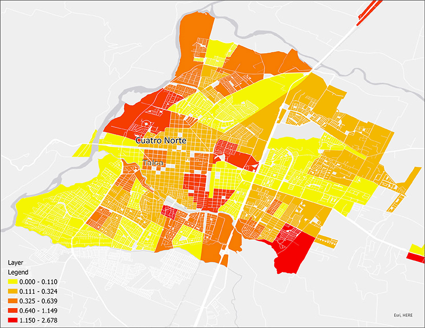
Figure 2. Percentage of housing units in Talca with irrecoverable housing materials, an indicator of housing quality (2017).
Talca has been the study area for a gentrification study, though not in relation to greening. Inzulza-Contardo (2016) conducted a study in four historic neighborhoods in Talca examining the reconstruction process, following the 2010 earthquake, using Cuatro Norte as a study area boundary. Their findings indicated the presence of gentrification caused by housing subsidies, allowing “urban plots and increasing land value rather than the protection of owner conditions and/or affordability for residents to keep living in the inner city” (Inzulza-Contardo, 2016, p. 2025).
For the Santiago Province we focused on three new or newly renovated parks: Andre Jarlán, Bicentenario, and Quinta Normal. These parks are located in three comunas with different socio-economic characteristics, as shown in Figure 4. Andre Jarlán, with an area of 320 thousand square meters, is located in the southern Pedro Aquirre Cerda comuna and is a historic park that was remodeled and reopened in 1997 (Figure 3c). Bicentenario, with an area of 314 thousand square meters, is located in the northeast Vitacura comuna and is the newest park out of the three we chose (Figure 3d). It was built in 2007 with anticipation that it would attract 75,000 new residents to the area (Lopez-Morales, 2011). Most parks are (in theory) designed to serve the public, yet with the rise of novel, high profile parks, such as Promenade Plantée in Paris or the High Line Park in New York City, city officials around the world are inspired to build similar world-class green spaces to generate economic development and attract global attention. Bicentenario is an example for this category, but in the Global South. Quinta Normal, with an area of 355 thousand square meters, is located in a western Quinta Normal comuna and is also a historic park that was also remodeled with new additions and more acres were added in 2008 (Figure 3b).

Figure 3. Photos of Quinta Normal (b), Andre Jarlán (c), and Bicentenario (d), and Cuatro Norte (a) Sources: (b) Wikimedia Commons https://commons.wikimedia.org/wiki/File:Parque_Quinta_Normal,_Santiago_de_Chile.JPG; (c) FAHNEU https://fahneu.cl/imagen/parque-andre-jarlan-pedro-aguirre-cerda; (d) TripAdvisor https://www.tripadvisor.com/ShowUserReviews-g294305-d3236426-r329849129-Parque_Bicentenario-Santiago_Santiago_Metropolitan_Region.html; (a) MAPIO https://mapio.net/s/25908192/.
These are indeed very different comunas as Otero et al. (2021) described in their cluster analysis: Pedro Aquirre Cerda was classified as “lower-middle-class areas,” Vitacura was classified as “affluent area,” and Quinta Normal was classified as “urban crime area.” Rental housing affordability varies greatly between the three comunas, as the study of Vergara-Perucich and Aguirre-Nuñez (2020) using 2017 data indicates: Pedro Aquirre Cerda and Quinta Normal are more affordable when compared to Vitacura, which has the highest rental housing price within the greater Santiago region. This illustrates what Macedo and Haddad (2016) describes as the process of ground rent accumulation on the part of private largest-scale real estate firms, and he argues that if this process remains untouched, segregation will not stop.
Furthermore, even the spatial distribution of the bicycling network in greater Santiago and its use by residents demonstrate how segregated the capital is, with most travels being generated at the east part, where Vitacura comuna is located (Mora and Moran, 2020). From an urban ecosystems services perspective, Dobbs et al. (2018) conducted a spatial analysis 1986–2014 and found that “Santiago showed a socioeconomic effect, where social inequalities matched environmental inequalities represented by lower provision of ecosystem services” (p. 1077). Based on their study, Pedro Aquirre Cerda and Quinta Normal would have experienced degraded ecosystem services during the period of study, and Vitacura, a more affluent comuna, would showed improved ecosystem services. Even though the city is implementing Smart City strategies with the goal to diminish this segregation, among others, Jirón et al. (2020) found that some of these strategies “are intended to have a placebo effect” (p. 615), i.e., they will not change the problem, but alleviate the perception for residents will connect Santiago with the “world-class city” concept.
Table 1 depicts characteristics of the three comunas, with different population density varying from 3,104 to 14,041. One can observe Vitacura had the largest amount of authorized square meters of new construction during 2015–2020, contrasting with Pedro Aguirre Cerda that had the smallest area of 33,366 m2. These contrasting development levels may be related to the age of the neighborhoods located in these comunas: Vitacura has new neighborhoods on the edge of the province, and the other two are traditional established comunas with older neighborhoods.
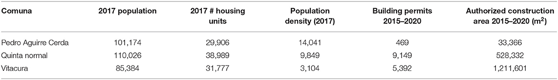
Table 1. Characteristics of the three comunas where Santiago parks are located.
Figure 4 shows location of the three urban parks and the percentage of population below the poverty line for all of the comunas in Santiago Province for 2017. The western part of the province was poorer than the eastern, direction to where the region is growing. The three parks are located in different gradients of poverty, being Bicentenario in lower poverty, Quinta Normal in medium poverty, and Andre Jarlán in higher poverty, when comparing the three. This figure illustrates López-Morales (2018) statement about gentrification in Santiago: the wealth distinction between comunas generates “material and symbolic exclusion” of the less affluent.
Data Collection
In this study, we utilized GSV to virtually observe locations and collect data based on human observation in Talca and Santiago, Chile, to investigate whether this technology can be effective in evaluating key characteristics of the built environment in diverse urban contexts. We aimed to determine whether GSV technology can serve as a reliable and cost-effective method of analysis compared to direct observation (Rundle et al., 2011; Kelly et al., 2013; He et al., 2017). We also aimed to determine if GSV is a viable and reliable method to investigate indicators of green gentrification. For in situ and virtual data collection, we designed a survey questionnaire. Questions about some notable features which may represent green gentrification in the Chilean urban context were included, such as land-use composition, materials used in the façades, the presence of aesthetic improvements, and pedestrian amenities. This survey was used in all four parks: one for in situ observation in Talca, and four for virtual observations: one in Talca and three in Santiago. The design of the survey was a continuous process that was finalized after four rounds of testing the instrument, by checking it with the in situ and virtual built environment, as described in the data analysis section.
When designing the questions, we considered the differences in the built environments between Latin American and North American cities. For example, we created a question in the survey about the type of façade material because in Latin America, buildings and homes use different materials depending on the socio-economic level of residents. For example, the presence of marble or glass as a building façade could indicate a higher socio-economic level. There were also questions about security features such as metal bars on windows and graffiti because this is a common occurrence in many neighborhoods in Latin America that indicates higher-socioeconomic and lower-socioeconomic levels, respectively.
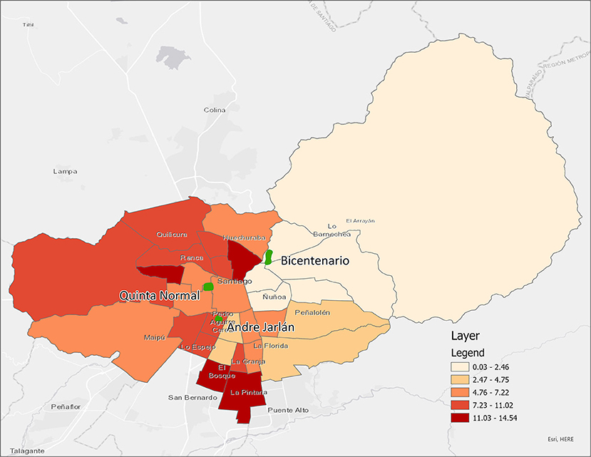
Figure 4. Percentage of population below the poverty line per comuna in Santiago Province (2017).
The survey instrument used in both Talca and Santiago included 11 questions regarding neighborhood conditions and amenities (Table 2). Each question response varied on a scale, including Boolean, Likert (none, 0–25, 25–50, 50–75, over 75%), or a choice of relevant options. Visibility questions utilized this scale to indicate the proportion of the feature that was seen, and questions of prevalence applied the same scale to the coverage of the block surrounding the location under observation. The question regarding the condition of the street applied the Likert scale of prevalence to indicate the proportion of the roadway affected by features such as potholes, cracks, construction, or a continuous curb. Possible answers to questions had features that could be present in higher socio-economic areas such as continuous curb along streets or in lower socio-economic areas such as presence of potholes—both for conditions of street.
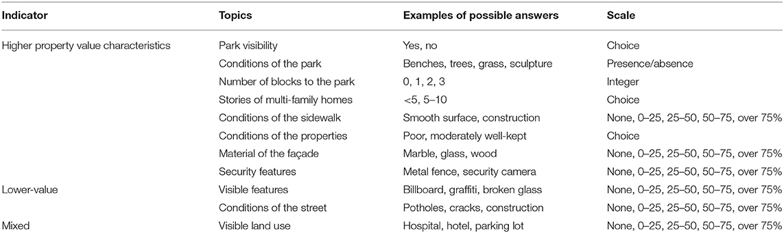
Table 2. Topics of questions included in the survey.
For Talca, we defined 37 locations in a regular grid of navigable streets surrounding Cuatro Norte, using a stratified sample from the park, extending four blocks north and south, and along the park at two block intervals. Figure 5 shows Cuatro Norte with the sampling locations: the 37 red points were used for the virtual observation, and the 18 blue circles represent the locations used for the in situ observation and comparison. Identical surveys were used in both the virtual and in situ observation. For in situ observations, looking ahead a block to the north, south, west, and east of the exact standing location, we recorded the precise longitude and latitude of the virtual observation. Using a smartphone, we recorded responses to the survey questions for the 18 locations. Independently, we conducted virtual observations of 37 locations, with complete overlap with the in situ observation. All imagery observed in Talca was collected by Google in 2013 and 2015.
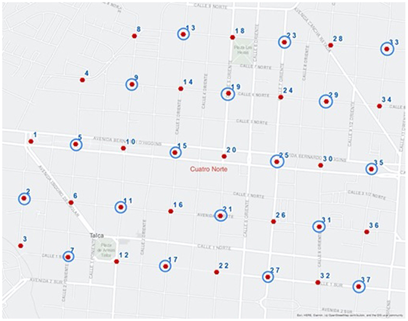
Figure 5. Sampling locations surrounding Cuatro Norte, Talca.
In Santiago, the boundaries of each park were delimited from official shapefiles, and buffers of 500, 1,000, and 1,500 m were calculated using ArcGIS 10.6.1. Areas for which sampling was impractical or infeasible (e.g., due to coverage of military bases, conservation zone, golf course, a vacant lot, and museums) were excluded from the buffer zones. Ten target locations for observations were randomly calculated within each buffer with a minimum distance of 100 m between each point, for a total of 30 points surrounding each of the three parks (Figure 6). The yellowish areas show places where gentrification is not possible to occur (i.e., development not possible), including areas of parks, golf courses, military bases, conservation zones, and museums. Geographic coordinates were extracted from each point and converted into location-specific links to target each point in Google Street View for virtual observation. All imagery observed in Santiago was collected by Google in 2014 and 2015, except for 5 locations observed in 2012.
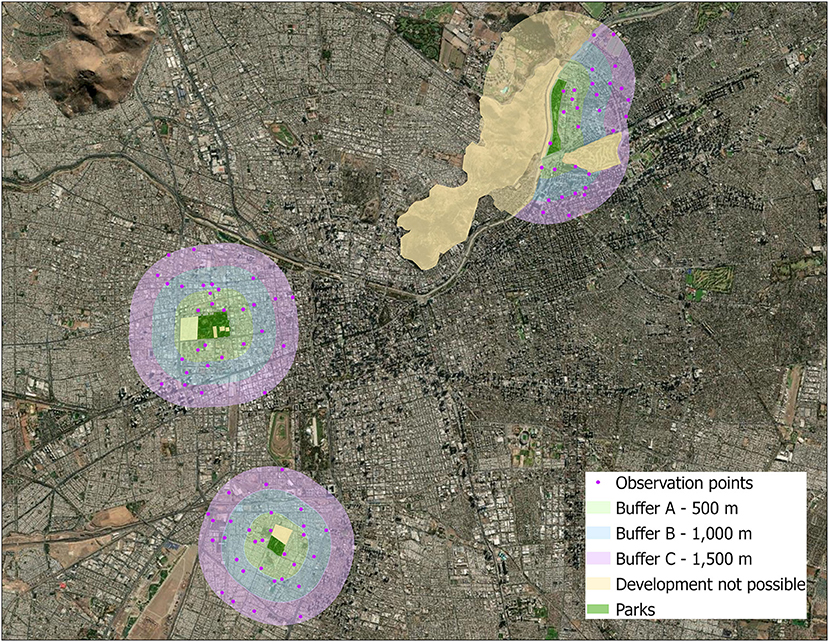
Figure 6. Map of study area in Santiago with buffers and observation points.
Data Analysis
Responses from the Talca in situ and virtual surveys data were compiled and summarized to address Research Question 1 establishing correspondence between the in situ and virtual observations. In the case of ordinal variables along a scale, results from each collection type were compared using direct agreement (responses identical) and adjacent agreement (responses varied ± one step on a scale). The direct agreement and the adjacent agreement were summed to yield a metric of total agreement between the in situ and virtual field observations. To illustrate, if the security feature metal fence in location x was 0–25% visible in both in situ and virtual observation, it was considered direct agreement. If the security feature metal fence in location x was 0–25% visible in in situ and 25–50% visible in virtual observation, it was considered adjacent agreement.
Next, we evaluated the response of each variable from Talca for potential inclusion in the resulting analysis. In locations of complete presence or absence, results were tabulated but not further examined, as they offered no metrics of comparison. For locations in which the responses differed substantially, the differences were noted and discussed in terms of varying conditions, timing of observation, or the feasibility of consistent observation between the two methods.
Research Question 2 addressed the response of variables that may indicate green gentrification and how they varied across three park contexts and over distance from each park. Using the three buffers (500, 1,000, 1,500), we conducted the GSV virtual observation in the neighborhoods surrounding three Santiago parks. Responses were summarized to presence vs. absence when possible to clearly demarcate the patterns across the three distance-based buffer zones. Variables for which the response was not static (i.e., unchanged in magnitude among the three buffers) were selected for increased examination. For example, the presence of single-family dwellings diminished in frequency over the three buffer zones surrounding one park, but increased in frequency over the buffers for the other two parks. Similarly, the presence of security window bars diminished with distance from one park, decreased with distance from another park, and were constant (i.e., consistently not present) surrounding a third park.
In summarizing the Santiago virtual observation responses to address Research Question 3, the proportion of presence of each variable was compared in summary across all parks and across the buffers between parks. These results were summarized in Table 3, and sparkline graphs were generated to illustrate the direction of the trend among buffers for each park, and the proportion of variable response among all parks, per buffer and in total (Figure 6). Line graphs among per park buffers indicate whether the presence of each characteristic rose, fell, or remained constant with distance from the park. For example, the presence of smooth sidewalks is a feature of higher socio-economic areas. If the line graph starts with high presence close to the park (500 buffer) and decreases presence in 1,000 buffer and even more so in 1,500 buffer, then a trend for green gentrification could be observed. Bar charts across all parks indicate whether a characteristic was more/less prevalent per park at each respective buffer or among all observations. To illustrate, the presence of decorative pavers is a feature of higher socio-economic areas. If the bar chart starts with high presence close to the park (500 buffer) and does not change its presence in 1,000 buffer nor in 1,500 buffer, then no trend could be observed.
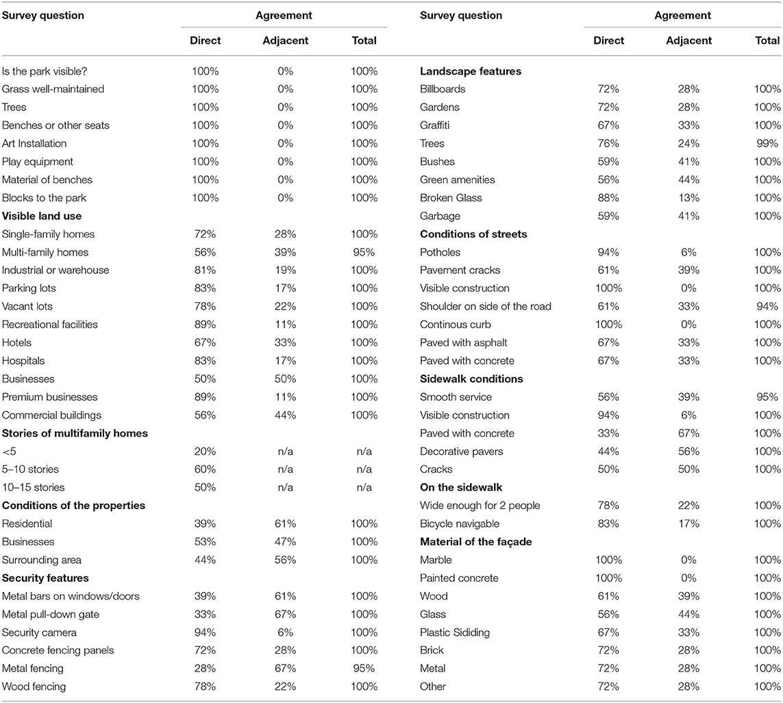
Table 3. Agreement of survey responses between in situ and virtual field observations.
Results
Findings From RQ 1: Agreement Between in situ and Virtual Observations
In response to Research Question 1, the correspondence between the in situ and virtual observations in Talca was very high among all survey questions (Table 3). For the visibility of the park, all attributes were consistent via direct agreement. Streetside elements like billboards, graffiti, green amenities, and litter were observed with 100% total agreement, though direct agreement ranges from 56.3 to 87.5%, supplemented by adjacent agreement of 12.5–43.8%, likely due to the differing timing affecting the abundance of the element but not its prevalence. Similarly, the abundance of land use types was improved by the use of adjacent agreement, which accounted for 11.1–38.9% of the observations, achieving 100% total agreement, except in the case of multi-family homes at 95%. This pattern of near-complete correspondence between the in situ and virtual observations continued for all observed variables.
Findings From RQ 2: Characteristics of Green Gentrification
Parsimony of observations aids in the detection of green gentrification in the Global South. While the same survey questions used in Talca were also used in the virtual-only observations of Santiago, a subset is reported here to reduce redundancy and highlight findings. The visibility of the park and park features did not necessarily serve as a reliable indicator of the presence of green amenities, due to the varying uses and compositions of surrounding blocks and also the lack of visibility from locations that were not adjacent or orthogonal to the park.
Similarly, many variables served as an indicator by a choice, in that a building may not be made of more than one facade material, so the use of a single choice served as an indicator that other types may or may not also be present, based on its proportion. In Santiago, the brick façade was more universally common than any other type, so its absence indicated some other type in use. Some variables were not mutually exclusive, such as the potential presence of Single- or Multi-family Dwellings and Businesses within a single block, or the different types of security features.
Hence, the full suite of questions used in the survey was reduced to include nine variables that may serve as indicators of green gentrification in this study: the presence of green amenities, the different types of land uses, the presence of security features, and the condition and composition of the facade and sidewalk materials. The comparative examination of the presence of these variables can enable cross-site comparison of green gentrification across a city, and the change of each variable over distance from a single park can give an indicator of the influence of the introduction or improvement of the park.
Findings From RQ 3: Evidence of Green Gentrification Near Parks in Santiago
For Santiago parks, results from the survey question responses of the 9 location characteristics, with 10 observations for each of 3 distance buffers, at each of the 3 parks are summarized in Table 4. Each of the nine variables illustrates an increasing, decreasing, or stable trend across the per-park buffers, and this trend gives insight into the characteristics of the urban context that may be indicative of green gentrification. Additionally, one can visualize the trend pattern of each of the variables with a linear sparkline.
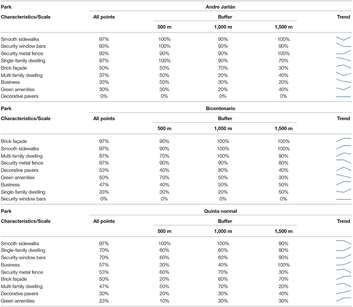
Table 4. Prevalence of selected characteristics surrounding each park, in total and by 500, 1,000, and 1,500 m buffers.
For Andre Jarlán and Quinta Normal, there was a positive (increasing) slope with increasing distance from the park for Green Amenities, but Bicentenario exhibited an inverse relationship, with the prevalence decreasing with distance from the park.
Residential buildings (Single-family or Multi-family) also exhibited differing trends among the parks, with an increase in single-family dwellings with increased distance in the neighborhood surrounding both Bicentenario and Quinta Normal, but a decrease in single-family dwellings with increased distance from Andre Jarlán. Multi-family trends were more variable in response, with slightly v/n-shaped curves in all cases, indicating differing neighborhood composition with increased distance. It may be harder to see the effect of green gentrification surrounding an established park like Andre Jarlán and Quinta Normal because of the lag in improvements in an established neighborhood. Because of the neighborhood improvements following the introduction of Bicentenario, many distance effects are more pronounced, but also share similarities with the other two parks. For example, the increased prevalence of multi-family dwellings closer to Bicentenario may be reflective of increased land values closer to the park, thereby indicating green gentrification resulting from this introduction of this park. Security window bars and security metal fencing (such as a shop or garage door) also exhibited differing trends with distance, with window bars more common adjacent to the park in the neighborhood surrounding Andre Jarlán and increasing with distance from Quinta Normal; the security metal fencing exhibited the opposite pattern. Brick façades, smooth sidewalks, and decorative pavers offered another line of discrimination among the park characteristics, with differing trends for each of the parks.
Summarizing the buffers across all parks yields insight into the characteristics that may be most commonly recognized as influenced by proximity to the park. Green amenities and multi-family dwellings, along with security metal fences, brick façades, and decorative pavers were most associated with the newly-established Bicentenario park. By contrast, single-family dwellings, businesses, and both types of security features were emblematic of the neighborhood surrounding Andre Jarlán. Smooth sidewalks were present in both of the neighborhoods, surrounding Andre Jarlán and Quinta Normal, though this characteristic did not vary dramatically with distance.
At the furthest buffer from the park, the neighborhood composition has shifted, with green amenities most associated with Andre Jarlán, single-family dwellings with Quinta Normal, and multi-family dwellings with Bicentenario.
Across all observations, the neighborhood surrounding Bicentenario is most rich with green amenities, decorative pavers, brick façades, and multi-family dwellings, whereas businesses were most prevalent surrounding Quinta Normal and single-family dwellings (and security features) most associated with Andre Jarlán. The responses to these variables helped to interpret evidence of green gentrification based on their patterns.
The Santiago analysis showed that virtual field observations can indicate green gentrification based on the spatial patterns seen from buffer to buffer. There was variation in the types of characteristics indicating gentrification among Bicentenario and Ardre Jarlán. Bicentenario's strongest indicators of green gentrification were green amenities and a security fence. Andre Jarlan's strongest indicators were single-family homes, businesses, and security window bars. Quinta Normal, arguably, did not demonstrate any strong spatial patterns of green gentrification across any indicators, potentially because it is difficult to attribute that change of the built environment to the parks if they have been there for many years.
Discussion
One of the goals of this study was to assess how well GSV fared in surveying the built environment and to understand how this compared with an in situ study. Based on the comparison to an in situ observation, we learned that GSV has the ability to effectively capture conditions of the built environment and it may be a valuable tool to measure green gentrification. It is an interesting and potentially exciting approach to study green gentrification, and our findings support similar research on in situ and virtual GSV studies on gentrification in the Global North (Hwang and Sampson, 2014; Ilic et al., 2019).
This finding supports the use of GSV to complement and extend methodology previously used, which largely rely on comprehensive secondary governmental or commercial data sources. In this way, GSV-based observations mirror the insights from in situ by offering precise locational information regarding a range of factors uncommonly captured by aggregated data. Further, GSV offers an advantage of being nearly comprehensive in coverage, with increasing potential for multiple observations over time. However, our results suggest that this approach must be used with caution because there are potential challenges.
From the Talca phase, two issues should be kept in mind as the methods presented here should be utilized in other studies: day of in situ visits, and year of the street-level imagery. Both issues are related to some features that were either not seen or did not appear in the virtual observation in comparison to the in situ, and vice-versa. First, the day of week chosen for in situ observations made a difference in what one could observe. The Talca in situ took place on different days. One day was Sunday when most stores and businesses were closed, making it easier to observe the streets, and more was seen in comparison to the other in situ visits not on Sunday. Second, if GSV images are older, then during virtual observations some features that were added to the built environment after the images were taken, will be present in the in situ but not in the virtual observations, which may mislead the results.
Concerning the survey questionnaire, there were questions such as the building façade that did not show a lot of variability. On the other hand, the survey question about multi-family and single- family homes gave us more variability, leading to meaningful information based on what was already known about the socio-economic background of that park. The results highlighted what key questions or variables should be used to address green gentrification in the Global South. For future survey questionnaires additional topics that could be included to bring more insights about green gentrification follow: the level of maintenance of the buildings, the presence and level of maintenance of landscape projects in the buildings surroundings, and the presence and conditions of electric poles in the sidewalks.
Our study highlights the importance of understanding the local context to develop relevant indicators based on street-level characteristics. Local knowledge about neighborhoods needs to be incorporated into the interpretation of indicators. Engaging local experts to guide the decisions about greening is essential for well-informed decision-making processes.
The results of this study suggest that there is a complex relationship between park investments and property upgrades, such that gentrification isn't an inevitable consequence of creating new parks or renovating existing ones. The data analysis showed some indicators of property upgrades in close proximity to the parks, but the indicators showing gentrification-related trends varied across all three parks, and multiple indicators did not show evidence of upgrades. These results complicate the park-gentrification relationship, similar to several recent citywide studies of green gentrification that show that gentrification isn't an inevitable outcome of park investments. Rigolon and Németh (2020) study of ten cities in the United States found that park function and location were stronger predictors of gentrification than park size. Similarly, Pearsall and Eller (2020) found that parks likely anchored gentrification in certain neighborhoods, but was not a driver of gentrification in others. Finally, Kim and Wu's (2021) study of parks in New York City revealed that park characteristics had an impact on gentrification outcomes over the medium- and long-term. While these three studies are all based on North American cities, our study contributes an additional line of evidence of the complexity of park-related gentrification based on a study in Latin America. Further, our study is one of the first that focuses on property upgrades, rather than demographic change, which provides a new perspective on neighborhood redevelopment linked to park investments. Given that our study did not show strong or consistent evidence of gentrification in proximity to the three parks, these parks might be an example of “just green enough” park development. This concept suggests that neighborhoods can be greened or improved, but not to the point that they attract substantial additional investment to become gentrified. We suggest that there is need for further research on neighborhood dynamics surrounding the three parks to understand if these park investments represent a “just green enough” example, or if other local or city processes are driving neighborhood investments that may result in gentrification over time.
Data Availability Statement
The raw data supporting the conclusions of this article will be made available by the authors, without undue reservation.
Author Contributions
MH contributed to literature review, organization paper, and map design. ZC contributed to data analysis and table design. HP contributed to literature review and the editing. MS collected the data. All authors contributed to the interpretation of findings, to the article and approved the submitted version.
Conflict of Interest
The authors declare that the research was conducted in the absence of any commercial or financial relationships that could be construed as a potential conflict of interest.
Publisher's Note
All claims expressed in this article are solely those of the authors and do not necessarily represent those of their affiliated organizations, or those of the publisher, the editors and the reviewers. Any product that may be evaluated in this article, or claim that may be made by its manufacturer, is not guaranteed or endorsed by the publisher.
References
Abel, T. D., White, J., and Clauson, S. (2015). Risky business: sustainability and industrial land use across Seattle's gentrifying riskscape. Sustainability 7, 15718–15753. doi: 10.3390/su71115718
Amarante, V., Galvan, M., and Mancero, X. (2016). Inequality in Latin America: a global measurement. Cepal Rev. 118, 25–44. doi: 10.18356/a7337ed5-en
Anguelovski, I., Connolly, J., and Brand, A. L. (2018). From landscapes of utopia to the margins of the green urban life: for whom is the new green city? City 22, 417–436. doi: 10.1080/13604813.2018.1473126
Arsanjani, J. J., Tayyebi, A., and Vaz, E. (2016). GlobeLand30 as an alternative fine-scale global land cover map: challenges, possibilities, and implications for developing countries. Habitat Int. 55, 25–31. doi: 10.1016/j.habitatint.2016.02.003
Betancur, J. J. (2014). Gentrification in Latin America: overview and critical analysis. Urban Stud Res. 2014:86961. doi: 10.1155/2014/986961
Borsdorf, A., and Hidalgo, R. (2013). Revitalization and tugurization in the historical centre of Santiago de Chile. Cities 31, 96–104. doi: 10.1016/j.cities.2012.09.005
Breen, A., Giannotti, E., Flores Molina, M. A., and Vásquez, A. (2020). From ‘Government to Governance'? A systematic literature review of research for urban green infrastructure management in Latin America. Front. Sustain. 2:52. doi: 10.3389/frsc.2020.572360
Bryson, J. (2012). Brownfields gentrification: redevelopment planning and environmental justice in Spokane, Washington. Environ. Justice 5, 26–31. doi: 10.1089/env.2010.0045
Bunce, S. (2009). Developing sustainability: sustainability policy and gentrification on Toronto's waterfront. Local Environ. 14, 651–667. doi: 10.1080/13549830903097740
Checker, M. (2011). Wiped out by the “greenwave”: environmental gentrification and the paradoxical politics of urban sustainability. City Soc. 23, 210–229. doi: 10.1111/j.1548-744X.2011.01063.x
Connolly, J. J. (2019). From Jacobs to the just city: a foundation for challenging the green planning orthodoxy. Cities 91, 64–70. doi: 10.1016/j.cities.2018.05.011
Curran, W., and Hamilton, T. (2012). Just green enough: contesting environmental gentrification in Greenpoint, Brooklyn. Local Environ. 17, 1027–1042. doi: 10.1080/13549839.2012.729569
De Mola, U. L., Ladd, B., Duarte, S., Borchard, N., La Rosa, R. A., and Zutta, B. (2017). On the use of hedonic price indices to understand ecosystem service provision from urban green space in five Latin American megacities. Forests 8:478. doi: 10.3390/f8120478
Delgadillo, V. (2016). Selective modernization of Mexico City and its historic center.Gentrification without displacement?. Urban Geogr. 37, 1154–1174. doi: 10.1080/02723638.2015.1096114
Dobbs, C., Hernández-Moreno, Á., Reyes-Paecke, S., and Miranda, M. D. (2018). Exploring temporal dynamics of urban ecosystem services in Latin America: the case of Bogota (Colombia) and Santiago (Chile). Ecol. Indicat. 85, 1068–1080. doi: 10.1016/j.ecolind.2017.11.062
Dooling, S. (2009). Ecological gentrification: a research agenda exploring justice in the city. Int. J. Urban Reg. Res. 33, 621–639. doi: 10.1111/j.1468-2427.2009.00860.x
Eckerd, A. (2011). Cleaning up without clearing out? A spatial assessment of environmental gentrification. Urban Affairs Rev. 47, 31–59. doi: 10.1177/1078087410379720
Fernández-Álvarez, R. (2017). Inequitable distribution of green public space in the Mexico City: an environmental injustice case. Econ. Sociedad y Territorio 17, 399–428. doi: 10.22136/est002017697
Gaffney, C. (2016). Gentrifications in pre-Olympic Rio de Janeiro. Urban Geogr. 37, 1132–1153. doi: 10.1080/02723638.2015.1096115
Gamper-Rabindran, S., and Timmins, C. (2013). Does cleanup of hazardous waste sites raise housing values? Evidence of spatially localized benefits. J. Environ. Econ. Manage. 65, 345–360. doi: 10.1016/j.jeem.2012.12.001
Glaeser, E. L., Kominers, S. D., Luca, M., and Naik, N. (2018). Big data and big cities: the promises and limitations of improved measures of urban life. Econ. Inq. 56, 114–137. doi: 10.1111/ecin.12364
Haddad, M. A. (2015). A framework for urban environmental planning in Brazil. Eur. Rev. Latin Am. Caribbean Stud. 113–125. doi: 10.18352/erlacs.10106/
Hammel, D. J., and Wyly, E. K. (1996). A model for identifying gentrified areas with census data. Urban Geogr. 17, 248–268. doi: 10.2747/0272-3638.17.3.248
He, L., Páez, A., and Liu, D. (2017). Built environment and violent crime: an environmental audit approach to using Google Street View. Comput. Environ. Urban Syst. 66, 83–95. doi: 10.1016/j.compenvurbsys.2017.08.001
Hinojosa, L., and Hennermann, K. (2012). A GIS approach to ecosystem services and rural territorial dynamics applied to the case of the gas industry in Bolivia. Appl. Geogr. 34, 487–497. doi: 10.1016/j.apgeog.2012.02.003
Houser, K. (2018). Google street view images could help us address a public health crisis. Neoscope. Retrieved from: https://futurism.com/neoscope/gsvgoogle-street-view-publichealth (accessed July 7, 2021).
Hwang, J., and Sampson, R. J. (2014). Divergent pathways of gentrification: racial inequality and the social order of renewal in Chicago neighborhoods. Am. Sociol. Rev. 79, 726–751. doi: 10.1177/0003122414535774
Ilic, L., Sawada, M., and Zarzelli, A. (2019). Deep mapping gentrification in a large Canadian city using deep learning and Google Street View. PLoS ONE 14:e0212814. doi: 10.1371/journal.pone.0212814
Immergluck, D., and Balan, T. (2018). Sustainable for whom? Green urban development, environmental gentrification, and the Atlanta Beltline. Urban Geogr. 39, 546–562. doi: 10.1080/02723638.2017.1360041
Inostroza, L. (2017). Informal urban development in Latin American urban peripheries. spatial assessment in Bogotá, Lima and Santiago de Chile. Landscape Urban Plann. 165, 267–279. doi: 10.1016/j.landurbplan.2016.03.021
Inzulza-Contardo, J. (2016). Contemporary Latin American gentrification? Young urban professionals discovering historic neighbourhoods. Urban Geogr. 37, 1195–1214. doi: 10.1080/02723638.2016.1147754
Irazábal, C. (2016). Public, private, people partnerships (PPPPs): reflections from Latin American cases, in Private Communities and Urban Governance, ed A. Lehavi (Cham: Springer), 191–214. doi: 10.1007/978-3-319-33210-9_9
Janoschka, M., and Sequera, J. (2016). Gentrification in Latin America: addressing the politics and geographies of displacement. Urban Geogr. 37, 1175–1194. doi: 10.1080/02723638.2015.1103995
Jirón, P., Imilán, W. A., Lange, C., and Mansilla, P. (2020). Placebo urban interventions: observing smart city narratives in Santiago de Chile. Urban Stud. 58, 601–620. doi: 10.1177/0042098020943426
Kelly, C. M., Wilson, J. S., Baker, E. A., Miller, D. K., and Schootman, M. (2013). Using Google street view to audit the built environment: inter-rater reliability results. Ann. Behav. Med. 45, S108–S112. doi: 10.1007/s12160-012-9419-9
Kern, L. (2015). From toxic wreck to crunchy chic: environmental gentrification through the body. Environ. Plann. D 33, 67–83. doi: 10.1068/d13150p
Kim, S. K., and Wu, L. (2021). Do the characteristics of new green space contribute to gentrification? Urban Stud. 1–20. doi: 10.1177/0042098021989951
Krellenberg, K., Well, J., and Reyes-Päcke, S. (2014). Urban green areas and their potential for social interaction – A case study of a socio-economically mixed neighborhood in Santiago de Chile. Habitat Int. 44, 11–21. doi: 10.1016/j.habitatint.2014.04.004
Lara-Valencia, F., and García-Pérez, H. (2015). Space for equity: socioeconomic variations in the provision of public parks in Hermosillo, Mexico. Local Environ. 20, 350–368. doi: 10.1080/13549839.2013.857647
Letelier, F., and Irazábal, C. (2018). Contesting TINA: community planning alternatives for disaster reconstruction in Chile. J. Plann. Educ. Res. 38, 67–85. doi: 10.1177/0739456X16683514
Lopez-Morales, E. (2011). Gentrification by ground rent dispossession: the shadows cast by large-scale urban renewal in Santiago de Chile. Int. J. Urban Regional Res. 35, 330–357. doi: 10.1111/j.1468-2427.2010.00961.x
López-Morales, E. (2015). Gentrification in the global South. City 19, 564–573. doi: 10.1080/13604813.2015.1051746
López-Morales, E. (2016). Gentrification in Santiago, Chile: a property led process of dispossession and exclusion. Urban Geogr. 37, 1109–1131. doi: 10.1080/02723638.2016.1149311
López-Morales, E., and Holloway, A. (2018). Just another chapter of Latin American gentrification, in Neoliberalism and Urban Development in Latin America. The Case of Santiago, eds C. Boano and F. Vergara-Perucich (London: Routledge), 503–516.
Macedo, J., and Haddad, M. A. (2016). Equitable distribution of open space: using spatial analysis to evaluate urban parks in Curitiba, Brazil. Environ. Plann. B 43, 1096–1117. doi: 10.1177/0265813515603369
Miller, J. T. (2016). Is urban greening for everyone? Social inclusion and exclusion along the Gowanus Canal. Urban Forestry Urban Greening 19, 285–294. doi: 10.1016/j.ufug.2016.03.004
Mir, D. F., and Sanchez, A. E. (2009). Impact of gentrification on environmental pressure in service micro-enterprises. Bus Strategy Environ. 18, 417–431. doi: 10.1002/bse.590
Mora, R., and Moran, P. (2020). Public bike sharing programs under the prism of urban planning officials: the case of Santiago de Chile. Sustainability 12:5720. doi: 10.3390/su12145720
Musakwa, W., and Van Niekerk, A. (2015). Earth observation for sustainable urban planning in developing countries: needs, trends, and future directions. J. Plann. Literat. 30, 149–160. doi: 10.1177/0885412214557817
Otero, G., Méndez, M. L., and Link, F. (2021). Symbolic domination in the neoliberal city: space, class, and residential stigma. Urban Geogr. doi: 10.1080/02723638.2021.1887632
Pearsall, H. (2010). From brown to green? Assessing social vulnerability to environmental gentrification in New York City. Environ. Plann C Govern. Policy 28, 872–886. doi: 10.1068/c08126
Pearsall, H. (2013). Superfund me: a study of resistance to gentrification in New York City. Urban Stud. 50, 2293–2310. doi: 10.1177/0042098013478236
Pearsall, H., and Eller, J. K. (2020). Locating the green space paradox: a study of gentrification and public green space accessibility in Philadelphia, Pennsylvania. Landscape Urban Plann. 195:103708. doi: 10.1016/j.landurbplan.2019.103708
Pearsall, H., Pierce, J., and Krueger, R. (2012). Whither Rio+ 20?: demanding a politics and practice of socially just sustainability. Local Environm. 17, 935–941. doi: 10.1080/13549839.2012.724899
Rigolon, A., Browning, M. H. E. M., Lee, K., and Shin, S. (2018). Access to urban green space in cities of the global south: a systematic literature review. Urban Sci. 2, 1–25. doi: 10.3390/urbansci2030067
Rigolon, A., and Németh, J. (2020). Green gentrification or ‘just green enough': do park location, size and function affect whether a place gentrifies or not? Urban Stud. 57, 402–420. doi: 10.1177/0042098019849380
Rundle, A. G., Bader, M. D., Richards, C. A., Neckerman, K. M., and Teitler, J. O. (2011). Using Google Street View to audit neighborhood environments. Am. J. Prevent. Med. 40, 94–100. doi: 10.1016/j.amepre.2010.09.034
Scopelliti, M., Carrus, G., Adinolfi, C., Suarez, G., Colangelo, G., Lafortezza, R., et al. (2016). Staying in touch with nature and well-being in different income groups: the experience of urban parks in Bogotá. Landscape Urban Plann. 148, 139–148. doi: 10.1016/j.landurbplan.2015.11.002
Sigler, T., and Wachsmuth, D. (2016). Transnational gentrification: globalisation and neighbourhood change in Panama's Casco Antiguo. Urban Stud. 53, 705–722. doi: 10.1177/0042098014568070
Smith, N. (1979). Toward a theory of gentrification a back to the city movement by capital, not people. J. Am. Plann. Assoc. 45, 538–548. doi: 10.1080/01944367908977002
Velázquez, M. E., Zumelzu, A., and Rodríguez, L. (2021). Exploring nodality and connectivity as dimensions to promote sustainable urban form in medium-sized Chilean cities: the case of Isla Teja in Valdivia. J. Urban. doi: 10.1080/17549175.2021.1908402
Vergara-Perucich, J. F., and Aguirre-Nuñez, C. (2020). Housing prices in unregulated markets: study on verticalised dwellings in Santiago de Chile. Buildings 10, 1–16. doi: 10.3390/buildings10010006
World Bank (2021). Indicators. The World Bank Group. Available online at: https://data.worldbank.org/indicator (accessed10 May, 2021).
Keywords: virtual fieldwork, Latin America, urban parks, Google Street View, gentrification
Citation: Haddad M, Christman Z, Pearsall H and Sanchez M (2021) Using Google Street View to Examine Urban Context and Green Amenities in the Global South: The Chilean Experience. Front. Sustain. Cities 3:684231. doi: 10.3389/frsc.2021.684231
Received: 23 March 2021; Accepted: 24 June 2021;
Published: 28 July 2021.
Edited by:
Clara Irazabal, University of Maryland, College Park, United StatesReviewed by:
Walter Imilan, Central University of Chile, ChileFrancisco Letelier, Catholic University of the Maule, Chile
Copyright © 2021 Haddad, Christman, Pearsall and Sanchez. This is an open-access article distributed under the terms of the Creative Commons Attribution License (CC BY). The use, distribution or reproduction in other forums is permitted, provided the original author(s) and the copyright owner(s) are credited and that the original publication in this journal is cited, in accordance with accepted academic practice. No use, distribution or reproduction is permitted which does not comply with these terms.
*Correspondence: Mônica Haddad, aGFkZGFkQGlhc3RhdGUuZWR1