 Mushtaq Ahmad Jan1
 Syed Irfan Ullah1
 Waheed Ullah2*
 Safi Ullah3Hisham Tariq4Terrence Fernando4Amjad Ali1
 Zahid Ur Rahman5
- 1Centre for Disaster Preparedness and Management (CDPM), University of Peshawar, Peshawar, Pakistan
- 2Defense and Security, Rabdan Academy, Abu Dhabi, United Arab Emirates
- 3Department of Atmospheric and Oceanic Sciences, Fudan University, Shanghai, China
- 4School of Science, Engineering and Environment, University of Salford, Manchester, United Kingdom
- 5Key Laboratory of Digital Earth Science, Aerospace Information Research Institute, Chinese Academy of Sciences, Beijing, China
Pakistan’s vulnerability to disasters necessitates effective disaster risk communication. This study presents a conceptual model of the PDMA Madadgar Application (hereinafter Madadgar) for subsequent code development and testing. Employing the design science research approach, data were collected through in-depth interviews from the purposefully selected sample participants and analyzed through the content analysis method. Our findings highlight the conceptualization of the app and the strengths it provides in real-time disaster alerts, early warnings and critical information dissemination. The data reveals that the model is highly interactive. A major stake has been provided to the local communities and field-based staff to receive and disseminate early warning messages, locate evacuation centers, report disasters without warning, and digitally conduct damage assessment. This study enhances disaster risk communication in Pakistan and informs the global development of effective mobile-based solutions. Maddagar is Pakistan’s pioneer interactive Android-based disaster risk communication app for communities in Pakistan. Madadgar directly contributes to the local implementation of Pakistan’s National Disaster Management Act 2010 and National Disaster Risk Reduction Policy-2013 as well as the Sendai Framework for Disaster Risk Reduction and the Sustainable Development Goals. While the current Madadgar model is specifically designed for use within the Khyber Pakhtunkhwa province of Pakistan, reflecting the decentralization of disaster risk reduction to the provinces following the 18th constitutional amendment, its underlying principles and architecture offer a scalable blueprint for adaptation and replication in other provinces and similar contexts.
1 Introduction
In disaster risk reduction (DRR), timely information communication through multiple means has a greater impact on saving lives and protecting assets. Empirical research shows that the dissemination of information through various platforms in multiple formats such as interactive maps, numerical weather data, advisories, warning messages, etc. has greatly influenced public perception and behaviors and are major component of disaster preparedness (Abunyewah et al., 2020). Information and communication technologies (ICTs) have played a key role in disaster communications and subsequent emergency response by enabling effective communication, data collection, analysis and decision-making (Khan A. et al., 2020; Stute et al., 2020). Technologies collecting data from weather stations, sensors, satellites and subsequent communication in simple understandable language via media, mobile apps, social media, emails, sirens, short message service (SMS), etc., have provided timely and accurate early warnings to vulnerable communities in the path of a disaster (Khan I. et al., 2022; Khan M. et al., 2022; Esposito et al., 2022; Khan A. A. et al., 2021; Khan I. et al., 2021; Khan M. et al., 2021). These technologies have improved the speed and accuracy of early warning systems, support informed decision-making, enable effective communication with affected communities and facilitate data-driven approaches to disaster management (Sarker et al., 2020). The need for employing ICTs in DRR, climate change adaptation (CCA) and sustainable development has been widely recognized, especially in the policies adopted at the United Nations (UN) level (Fan et al., 2021). Sustainable Development Goals (SDGs) Goal 9 “Industry Innovation and Infrastructure,” Goal 11 “Sustainable Cities and Communities,” Goal 13 “Climate Action,” and Goal 17 “Partnership for the Goals” support the domestication of information and communication technologies in achieving these goals (United Nations, 2015). In the context of DRR, the Sendai Framework for DRR supports the use of adaptive technologies to prepare for and mitigate disasters (UNDRR, 2015). Empirical research reveals that technology applications can significantly enhance transparency, public trust and coordination in DRR (Khan A. A. et al., 2021; Khan I. et al., 2021; Khan M. et al., 2021). Transparency through technological application is crucial for achieving sustainability in DRR and is relevant to the long-term viability of comprehensive disaster management systems (Khan I. et al., 2022; Khan M. et al., 2022).
Considering the global significance and welfare outcomes, various streams of research from social science, computer science and information science have been conducted to employ ICTs with artificial intelligence (AI) in DRR (Fan et al., 2021). Within these technologies, mobile phones have proved to be one of the most effective technologies in DRR ensuring timely access to information and its dissemination. More specifically, mobile phones have revolutionized early warning communication by providing timely and reliable information to individuals during emergencies. Their widespread use and accessibility make them an important tool for saving lives and mitigating the impact of disasters. It is a cost-effective and accessible means to enhance DRR efforts, empower individuals, and enable effective communication and coordination during emergencies. A review of some globally accessible disaster apps has been presented in Table 1. Out of these reviewed apps, Disaster Alert is the most widely adopted app due to its global focus and data-sharing feature for each country, followed by the International Federation of Red Cross (IFRC) First Aid app due to its educational nature.
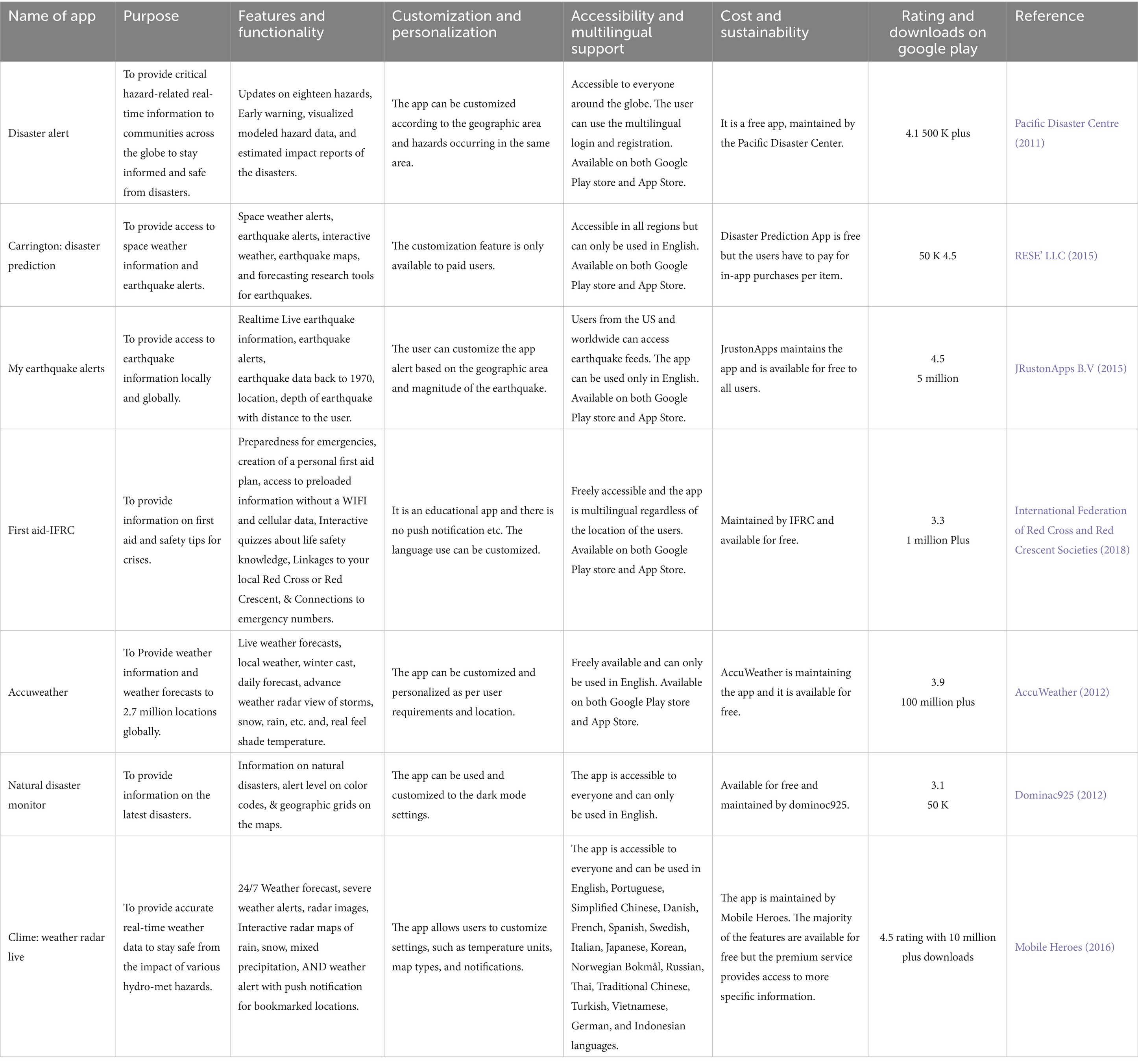
Table 1. Comparative analysis of disasters-related mobile applications at the global level.
Pakistan, a low-income country with diverse geographical features, is highly vulnerable to disasters. The increasing risks of disasters and the resultant impacts, in terms of mortality, injuries, infrastructure damage and mass displacement, have greatly affected developmental projects, the investment environment and the overall economy of Pakistan (Manzoor et al., 2022). Pakistan has suffered from multiple earthquakes (Khan et al., 2024; Ali A. et al., 2022; Ali N. et al., 2022), floods (Ali et al., 2024; Shah I. et al., 2020; Shah S. M. H. et al., 2020), landslides (Gardezi et al., 2021; Su et al., 2022), droughts (Khan I. et al., 2020), cyclones (Hussain et al., 2023a), glacial lake outburst floods (Khan I. et al., 2022; Khan M. et al., 2022; Qureshi et al., 2022), forest fires (Ullah et al., 2018), dust storms (Yarmohamadi et al., 2023), avalanches (Saif et al., 2022; Ali et al., 2023) and terrorism (Javeid et al., 2023) etc. Some of the recent disaster data reveals that the 2005 earthquake killed more than 73,000 people and rendered over 2.8 million people homeless (Pande, 2005). The flood of 2010 directly affected 20 million people (Atta-ur-Rahman and Khan, 2013) and the flood of 2022 affected 33 million people (Nanditha et al., 2023). The vulnerability of Pakistan to these disasters is attributed to multiple factors, including climate change and variability (Hussain et al., 2023a,b; Otto et al., 2023; Fahad and Wang, 2020), overutilization of natural resources (Khan A. A. et al., 2021; Khan I. et al., 2021; Khan M. et al., 2021), diverse topographic and temporal dimensions (Hussain et al., 2023a,b), weak implementation of building codes and poor quality of construction (Cheema, 2023; Shaikh et al., 2023), poor governance (Shehzad, 2023; Jan and Muhammad, 2020), rapid and unplanned urbanization (Tayyab et al., 2021; Zia et al., 2023), exponential population growth (Ullah et al., 2019), social inequality and poverty (Memon, 2023), lack of risk assessment (Tayyab et al., 2024; Shah et al., 2023a,b), weak inter-organizational collaboration (Yousefian et al., 2021; Jan and Muhammad, 2020), weak early warning system and its dissemination (Khayyam and Noureen, 2020; Rana et al., 2021; Javed Khan et al., 2019), lack of public awareness (Khan A. A. et al., 2021; Khan I. et al., 2021; Khan M. et al., 2021), weak risk communication (Ali A. et al., 2022; Ali N. et al., 2022; Shah et al., 2023a,b), digital divide, and lack of mainstreaming of ICTs within the domain of DRR (Sajida Tufail and Ainuddin, 2016; Anis and Ashfaq, 2023). Within these causes of vulnerability, the present study attempts to address the problems in disseminating early warning systems, faulty risk communication and weak collaboration between the disaster management authorities and communities in the northwestern province of Pakistan, i.e., Khyber Pakhtunkhwa. Analysis of recent disasters, specifically the 2022 Murree snowstorm, 2022 floods and 2025 Swat floods reveals persistent deficiencies in several key areas including timely risk communication, accessibility of early warning systems, levels of public awareness, effectiveness of information dissemination and the presence of dedicated risk communication platforms for community engagement (PDMA, 2025; Shah et al., 2023a,b; Meo et al., 2022; Asad, 2022). These challenges left people at the mercy of nature causing death tolls and infrastructure damage.
Besides, the Pakistan National Disaster Management Act 2010 (articles 16-2 J, 20-2 K), Khyber Pakhtunkhwa (KP) Emergency Rescue Service (Amendment) Act, 2014 (articles 4c), National Disaster Risk Reduction Policy 2013 and National Disaster Management Plan 2024 have clearly emphasized the use of harnessing information and communication technologies to strengthen early warning capacity and improve resilience through preparedness (Government of Pakistan, 2024a,b; Government of Khyber Pakhtunkhwa, 2014; Government of Pakistan, 2013; NDMA, 2012; I-SAP, 2010). In addition, the Pakistan Social and Living Standard Survey 2019–2020 indicates that 93.15% of the population have access to mobile phones and 11.75% own a laptop or computer (Government of Pakistan, 2021). The latest data further reveal that 193 million Pakistanis are active subscribers of various mobile network operators and the country was ranked 9th on the list of countries with mobile connectivity (Government of Pakistan, 2024a). At the start of 2024, Pakistan had 111 million internet users and 71.70 million social media users (Social and Meltwater, 2023). These statistics portray that due to the limited financial capacity to invest in telemetry stations, weather radars and automatic weather stations, a mobile-based solution can be the best source to scale up the existing early warning information and communication network.
Although Pakistan’s DRR system is still in the infancy stage and a paradigm shift from complete reactive disaster management to proactive risk reduction is yet to take place, efforts have been made to develop, harness, and domesticate mobile technologies in the disaster response and preparedness sector. As per Table 2 various app exist and operation for risk communication in Pakistan. These Pakistani apps are mostly static and there is no provision for the citizens to report back about their disaster-related problems. The only Pakistani app, i.e., Citizen Portal App empowers the citizens to report and file complaints about any government department from federal to district levels. In terms of disasters, the app enables local people to file complaints about delayed compensation for relief and cash packages. There is no mechanism to share early warning or any other disaster-related information (Prime Minister’s Performance Delivery Unit, 2018).
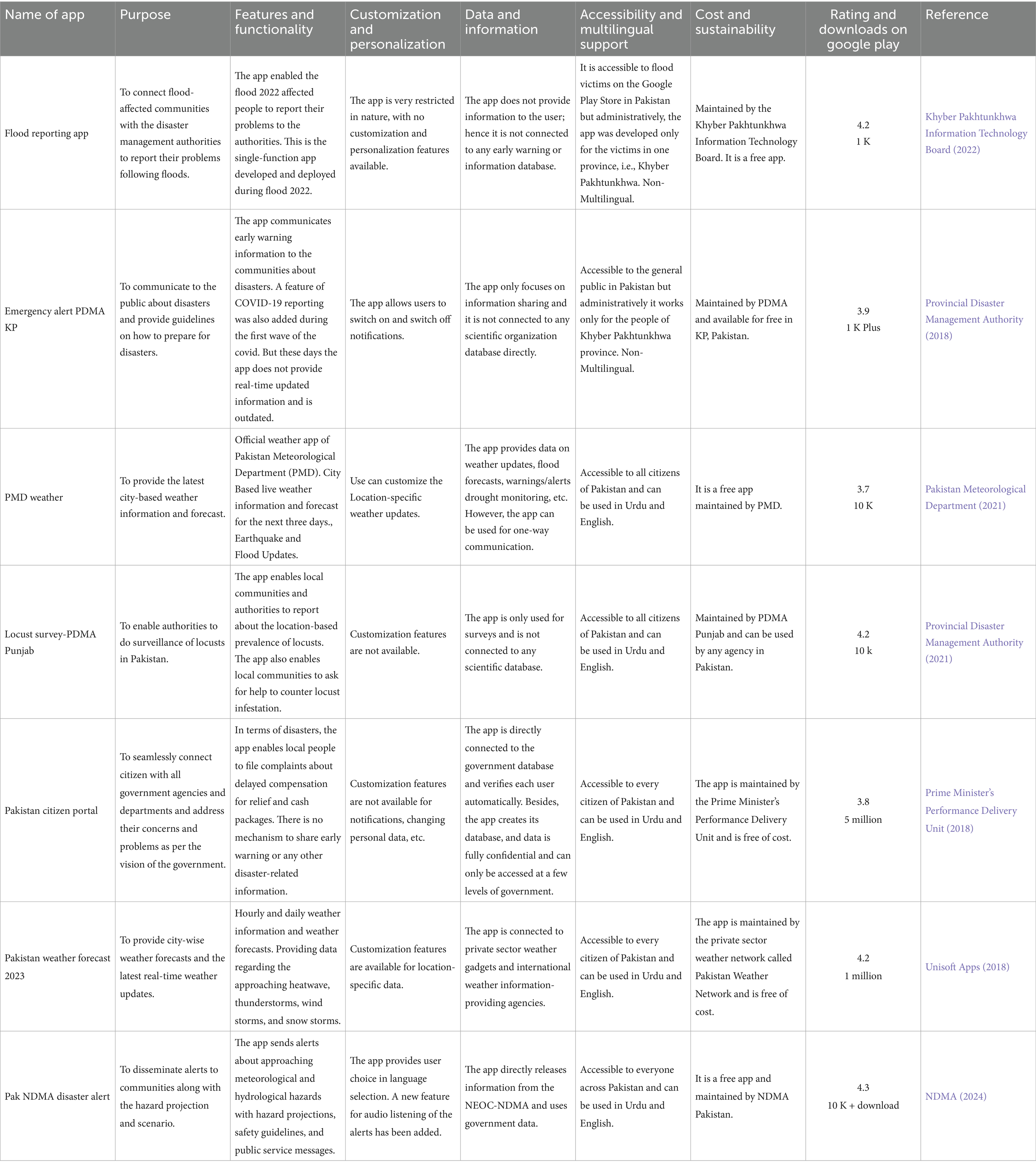
Table 2. Comparative analysis of disaster-related mobile applications in Pakistan.
Because of the given background, we have attempted to understand the current status of the application of mobile-based technologies in disaster risk communication in Pakistan. Similar to the existing apps, we have conducted a landscape analysis of the available mobile apps and identified the best use cases. Based on the landscape analysis and field-based data collection, we have conceptualized Madadgar in the context of the study area. Madadgar covers all disasters and the model is considered a super app for risk communication in KP. This innovative use of a mobile-based app for disaster communication aims to enhance access to real-time information and improve community resilience. The Madadgar is a user-friendly platform for timely risk communication, early warning systems and critical information dissemination. Through the use of this innovative technology, vulnerable communities can be better equipped to prepare for and respond to disasters, ultimately reducing the risk of harm and promoting resilience amid the climate change crisis (Jan et al., 2025). Madadgar only focuses on one province due to the devolution of the disaster, environment and climate change to the provincial level after the 18th Constitutional Amendment of 2010 (Shah I. et al., 2020; Shah S. M. H. et al., 2020). Each province has been empowered to develop and implement projects aimed at reducing disaster risk within its boundaries.
1.1 Theoretical framework of the study
This research was supported by a multidimensional theoretical framework, drawing on Socio-Technical Systems (STS) Theory, Diffusion of Innovations (DOI) Theory, Actor-Network Theory (ANT) and the principles of Participatory Design (PD). These frameworks collectively enabled a dynamic analysis of the Madadgar’s conceptual model, specifically examining the intricate relationship among mobile technology, DRR objectives and key stakeholder engagement within the KP context. STS theory emphasizes the inherent interdependencies between social and technical elements within a system. It posits that optimizing one without considering the other leads to poor outcomes or even system failure (Thomas, 2024; Ahmad et al., 2022; Dell et al., 2021). STS theory in this study’s context suggests that Madadgar’s success requires optimizing its technical features and integrating it with existing social and organizational structures within the KP disaster management system. This includes aligning with PDMA’s procedures, communication protocols among DRR agencies, the target population’s digital literacy and public trust. DOI explains how new ideas, practices or technologies spread through a social system over time, identifying factors influencing adoption such as relative advantage, compatibility, complexity, trialability and observability (Mbatha, 2024; Shaw et al., 2022; Frei-Landau et al., 2022; Call and Herber, 2022). The DOI framework allowed for an examination of the Madadgar’s perceived attributes, such as its relative advantage over traditional communication methods, its compatibility with existing cultural norms and communication habits, its complexity in terms of ease of use, its trialability (the ability for users to experiment with it), and the observability of its results. ANT offers a perspective by treating both human and non-human entities as “actants” with agency, forming interconnected networks (Ryan et al., 2024). For the PDMA Madadgar app, ANT allowed for a detailed mapping of the heterogeneous network involved in its conceptualization and deployment. Human actants include PDMA officials, app developers, community members, local government representatives, first responders and telecom providers. Non-human actants encompass the Madadgar app itself, smartphones, mobile networks, data, policies and even natural hazards. ANT helped in analyzing how these diverse actants interact, influence each other, and “translate” their interests to shape the app’s design, functionality and impact. This includes examining how the app’s technical specifications enroll users, how policy decisions facilitate network connectivity, and how user feedback (a form of human actants agency) might lead to app modifications (Lin and Yang, 2021; Singgalen, 2021). While not a singular theory, PD is an approach rooted in theoretical tenets of empowerment and co-creation, emphasizing the active involvement of all stakeholders throughout the design and development process. For the PDMA Madadgar app, this framework posits that the app’s relevance, usability and sustainability are significantly enhanced when the end-users and key implementers (stakeholders such as local communities, disaster management authorities and emergency responders) are directly engaged in its conceptualization and refinement (Kistenfeger et al., 2024; Messiha et al., 2023; Steinke et al., 2022; Trettin et al., 2021; Mauka et al., 2021). This approach ensures that the app addresses real-world needs and challenges faced by communities in Pakistan, incorporates local knowledge and communication preferences, and is culturally appropriate. By integrating these theoretical frameworks, this research aims to provide a comprehensive analysis of the PDMA Madadgar app’s conceptual model, offering insights into its potential as a ground-breaking tool for disaster risk communication in Pakistan while acknowledging the complex socio-technical dynamics and the indispensable role of stakeholder engagement in its success.
1.2 Research questions
• The present research aims to explore the two basic research questions, i.e.,
• What is the state of the art in mobile apps focused on risk communication and early warning in KP, Pakistan?
• What type of app is required to strengthen vertical and horizontal coordination between communities and disaster management authorities in KP?
2 Methodology
The main objectives of the study are to explore the uses of mobile-based technologies in disaster risk communication, to conduct a landscape analysis of existing DRR apps, conceptualize the idea of a collaborative Madadgar app and to develop an architecture of the Madadgar App. To achieve these objectives and to address the research questions, we primarily relied on using the Design Science Research (DSR) methodology. DSR is a research methodology that can employ both qualitative and quantitative methods, depending on the research goals and context. This approach is typically applied to a range of artifact categories, including algorithms, human-computer interfaces, design methodologies (including process models) and languages. DSR involves a combination of approaches to design, develop and evaluate innovative solutions. DSR effectively redefines reality, addressing human needs and challenges (Venable et al., 2017). In DSR the object of study is the conceptual development, design of an artifact, and evaluation of the artifact (Carstensen and Bernhard, 2019). It prioritizes the design and optimization of artifacts to improve their functional capabilities. There are five phases of the DSR methodology, i.e., construct a conceptual framework; develop a system architecture; analyze and design the system; build the (prototype) system; and observe and evaluate the system (Venable et al., 2017). As shown in Figure 1, we have used the first three phases, i.e., constructing a conceptual framework, developing system architecture and analyzing and designing the system with a qualitative approach in this study. The remaining steps were used in another study on Madadgar (Jan et al., 2025). DSR uniquely distinguishes itself from purely empirical, theoretical or standard software development approaches by proactively designing and constructing innovative, tangible artifacts to solve real-world problems. Unlike empirical studies that describe, theoretical research that models or typical software development that builds without explicit research rigor, DSR integrates systematic research methods, such as extensive literature reviews, stakeholder engagement and rigorous evaluation to create practically useful and theoretically grounded solutions (Jat et al., 2024; Koepp et al., 2024; Lidiawaty et al., 2024; Koepp et al., 2024; Huseynli et al., 2022). This problem-solving focus, particularly in addressing complex socio-technical challenges, like risk communication gaps aligns perfectly with DSR’s aim to transform and enhance reality by developing purposeful artifacts. Furthermore, DSR’s iterative nature, demonstrated by the phases covered in the present study and previous study on Madadgar, i.e., Jan et al. (2025) allowed for continuous learning and refinement, crucial for developing adaptable and sustainable DRR tools that evolve with user needs and emerging threats. Following is the description of step wise details:
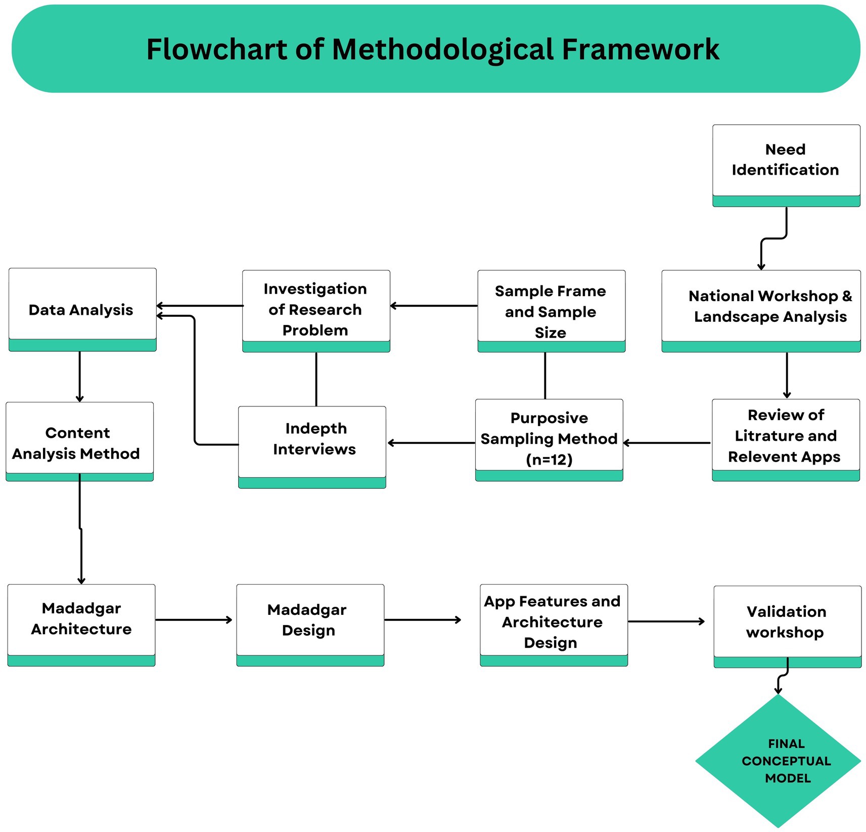
Figure 1. Design Science Research (DSR) steps followed for architecture development and conceptualization of the PDMA Madadgar App.
2.1 Need identification
In the first phase, the discussion on a DRR app for the communities was held at two national-level training workshops on “Flood Management through Flood Early Warning and Forecasting System” under one of our UNESCO-JICA joint-funded projects. Both workshops were attended by 100 officials from various civil protection institutions dealing with DRR at the national and provincial levels. In both workshops, the researchers used “Group Model Building Exercises” to discuss the concept of the early warning system, the existing mechanism of communication of warning messages and how mobile technologies can be used to improve communication and dissemination (Jan, 2018). At this stage, we explored the importance of a dedicated mobile app for the communities. Soon after the workshops, we organized an expo entitled “Technology-Mediated Expo on Disaster Risk Reduction, Climate Change Adaptation and Sustainable Development” at Peshawar (Jan et al., 2019). The researchers invited various tech vendors and agencies to the one-day expo, emphasizing the concept of DRR, Climate Change and SDGs. A total of 30 organizations and tech vendors exhibited their work at the expo. During the expo, it was noted that other types of technologies are being used to reduce disaster risk but there is a serious gap in Pakistan in terms of using mobile technologies for risk communication with the affected people. With the help of both events, we established the need for an interactive mobile app. These events also enable us to identify some of the existing apps that are in use in Pakistan for disaster risk communication (Tables 1 and 2).
2.2 Landscape analysis of identification and review of disaster risk communication app
In the second phase, we conducted a detailed review of the identified mobile apps on the Google Play Store at national and international levels. Apps identified during the workshop and expo were sampled as the majority of the research participants emphasized that they are using these apps to receive disaster-related information and guidance. Apart from these apps, many apps exist at the international level but they are not accessible in Pakistan and are context-specific to their countries. For the review, we established criteria to understand the purpose of an app; features and functionality; customization and personalization; data and information; accessibility and multilingual support; and cost and sustainability. During our review, we explored that the majority of Pakistani apps were static and the app developers or agencies responsible for DRR were able to communicate information to the public but there was no or very little room for the community to share information with authorities.
2.3 Stakeholder consultation (sampling method and sample size)
Both these steps enabled us to draw a list of potential organizations in the KP provincial capital for in-depth interviews to capture the requirements and determine the conceptualization of the PDMA Madadgar App. We prepared a list of potential DRR stakeholders from our previous study on multiagency collaboration for DRR in Pakistan (Jan and Ahmed, 2018), our consortium workshop reports (Mobilise Project Team-Pakistan, 2018), and the expo list (Jan et al., 2019). In total, we selected 10 organizations and 12 research participants through the purposive sampling method. Details of the organizations and research participants are mentioned in Table 3. The selection of participants was not arbitrary but based on specific criteria (1) “minimum of 5 years of experience in DRR,” (2) “terminal relevant academic qualifications” and (3) “an understanding of the use of ICTs in DRR.” This indicates a deliberate strategy to identify “information-rich cases” individuals who possess deep technical ICTs and DRR knowledge and practical experience directly relevant to the research questions concerning the conceptualization of Madadgar app. Using purposive sampling over other methods like random sampling was essential because the highly specialized nature of the domain necessitated participants with deep, specific knowledge and practical experience to generate relevant and valuable data, optimizing research efficiency and effectiveness. The approach ultimately ensures a robust app design that addresses complex inter-organizational collaboration in DRR.
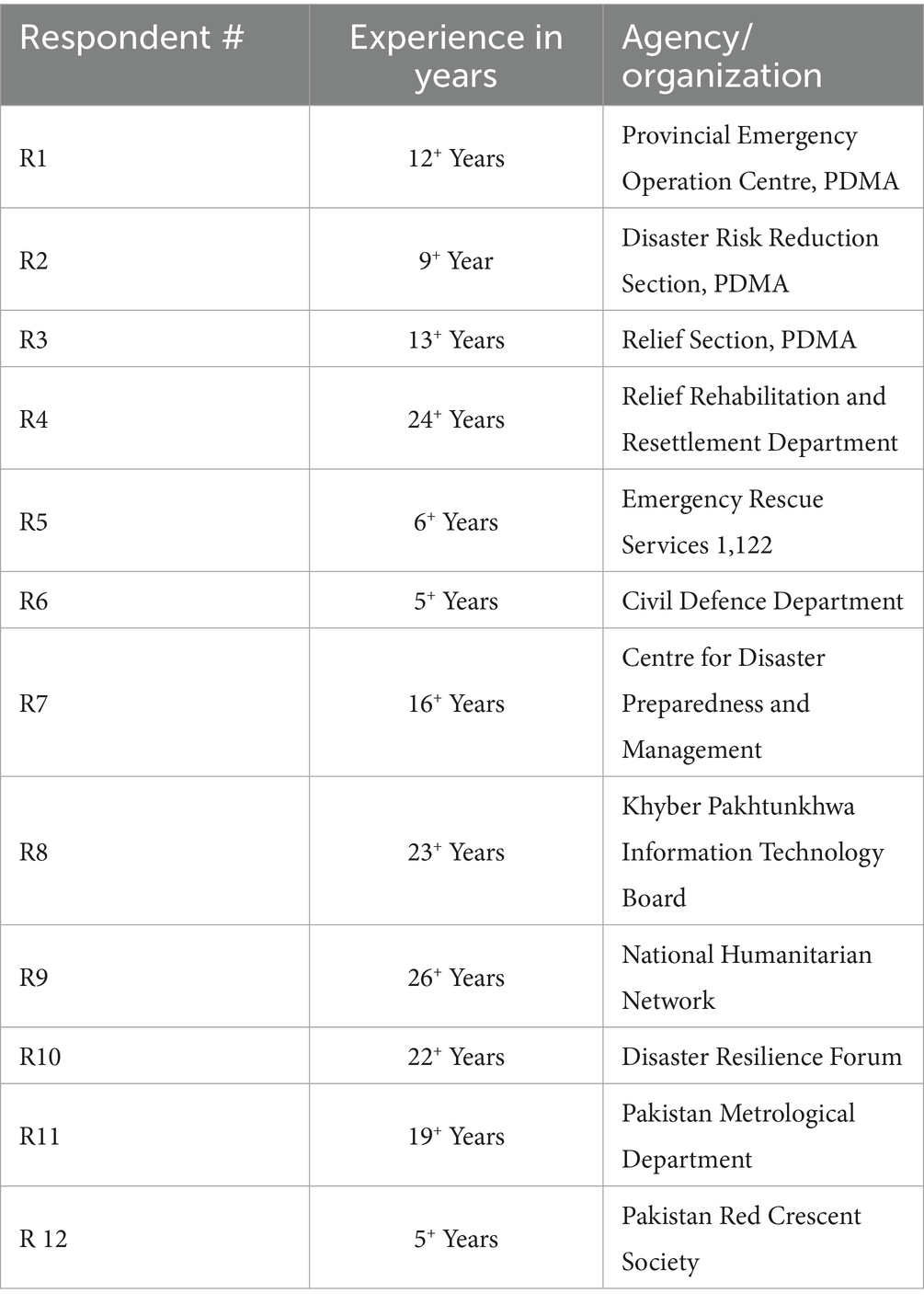
Table 3. IDI’s Respondents’ Profiles.
2.4 Investigation of the research problem: primary data collection
Based on the prompts and attributes identified during the literature review, we prepared an in-depth interview (IDI) checklist for primary data collection. The tool was designed to capture information about the app features as well as the interactive aspect to engage communities across the province. The tool consisted of various questions, including questions on the current use of ICTs, use of any mobile app for communication with communities, interest in the development of the dedicated mobile app, the purpose of such an app, basic features, modules/tabs to embed into the app, information the app should capture or disseminate, nature of the app (static or interactive), app language, color scheme, linking the app to external services like website and social media, architecture and any available domain to host both the frontend and backend of the app. Interviews were conducted in a face-to-face environment. For easy communication, the native language of Pashto and where required national language Urdu was used to conduct the interview. Word-to-word transcription of each interview was conducted soon after the conduction of the interview. Informed consent from each participant was taken before the interview.
2.5 Data analysis strategy
Employing the content analysis strategy, qualitative data analysis followed a rigorous process beginning with the meticulous transcription of each interview to convert spoken words into a systematic textual format. Subsequently, an inductive coding approach was employed, allowing codes and categories to emerge directly from the interview data through a process of text reduction, ensuring themes were grounded in participant perspectives. The content analysis employed a mixed-methods approach, integrating both deductive and inductive coding to systematically analyze interview data and inform the PDMA Madadgar App’s conceptual design. Deductive coding began with pre-defined categories and themes derived from our research questions, an initial landscape analysis of existing DRR apps (as detailed in Tables 1, 2) and the comprehensive in-depth interview checklist. This checklist was specifically developed based on prompts and attributes identified in the methodology’s second step, covering aspects like the app’s purpose, essential features, modules, information capture vs. dissemination, interactivity, language, design elements, external service linking, login services, architecture and hosting domains. These pre-established areas provided a structured framework for organizing the qualitative data. Conversely, inductive coding allowed specific codes and patterns to emerge directly from the primary interview data. Through a process of text reduction, we applied codes to specific words or patterns, identifying trends that ensured the app’s conceptualization was deeply grounded in the real-world experiences and needs of DRR experts and stakeholders. For instance, while “General Features of the App” was a deductive category, the concept of a “super app” integrating multiple components emerged inductively from participant feedback. Similarly, detailed functionalities within each tab (e.g., specific early warning types or disaster reporting mechanisms) were inductively derived from the interview content. This interplay between deductive and inductive approaches ensured our analysis was both systematic and flexible, effectively capturing emergent insights crucial for a comprehensive and responsive app design. This iterative coding scheme was continuously re-examined, including explicit checks for errors, typos or misspellings, to ensure consistent code application by the researchers. The codes were then organized into broader categories and patterns, forming the empirical basis for the app’s conceptualization, technically known as Software Requirement Specification (SRS) (317 to 360).
2.6 Reliability check, triangulation and validation
The study rigor was further maintained through expert validation via a “Validation Workshop.” In this critical step, we presented the app’s architecture and proposed concept to research participants for their validation and refinement. This member checking ensured the conceptual design accurately reflected the experts’ insights, thereby enhancing the trustworthiness of our conclusions and serving as a crucial form of code validation. The validated model was recommended for software-based development of Madadgar. Madadgar as an app is available on the Google Play Store for the use of both authorities and communities (Jan et al., 2025) and the algorithms/codes can be openly accessed on GitHub (Syedpg, 2025).
Complementing this, the study used both data and methodological triangulation. Data triangulation was achieved by comparing insights from a comprehensive literature review, an analysis of existing DRR apps and in-depth interviews, providing a richer understanding of app requirements. Methodological triangulation combined landscape analysis (document review) with in-depth interviews (primary data collection) and the validation workshop, offering a multi-faceted exploration of the problem space and potential solutions.
3 Results
The final conceptual model of the PDMA Madadgar App is presented here. During our investigation, we found that a few apps existed for communication with the communities but these were static. The concept of the PDMA Madadgar App empowers local communities to report incidents of disasters to PDMA-PEOC and conduct post-disaster Rapid and Damage Need Assessments. At present, the early warning system is based on the linear paradigm, where the authorities can only send information to the public but there is no mechanism to report an incident of disaster to the authorities. The PDMA Madadgar App provides access to real-time early warning messages, data related to damages from disasters, daily weather and daily situation reports, etc. The app enables the local communities to access location-based dedicated evacuation centers during times of emergencies. Authorities can send updates and news with push notification services to the public about any approaching threatening event. The risk assessment studies currently lying on shelves have been made accessible to the public. Besides, the public can file complaints to authorities about their disaster-related problems. Madadgar also serves as a dedicated platform to create awareness amongst the general public about disaster risk reduction. Lastly, Madadgar serves as a social media platform for the PDMA. All social media pages of the PDMA and different websites can be accessed from the app. The app provides access to all emergency helplines and office numbers of the district disaster management authority. The final concept through the content analysis strategy has been presented in Tables 4, 5, whereas the PDMA Madadgar App architecture can be seen in Figure 2 and a visual overview of the Madadgar App has been presented in Figure 3.
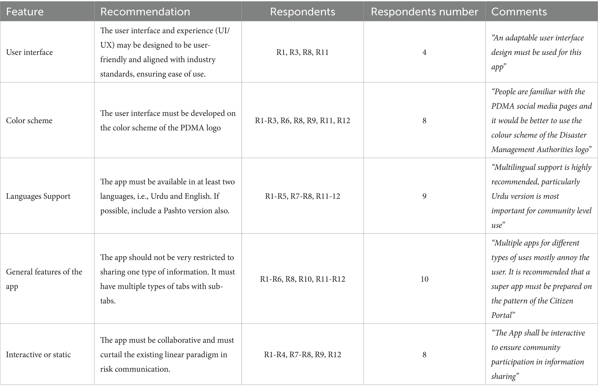
Table 4. Material design, user interface, language, and information sharing.
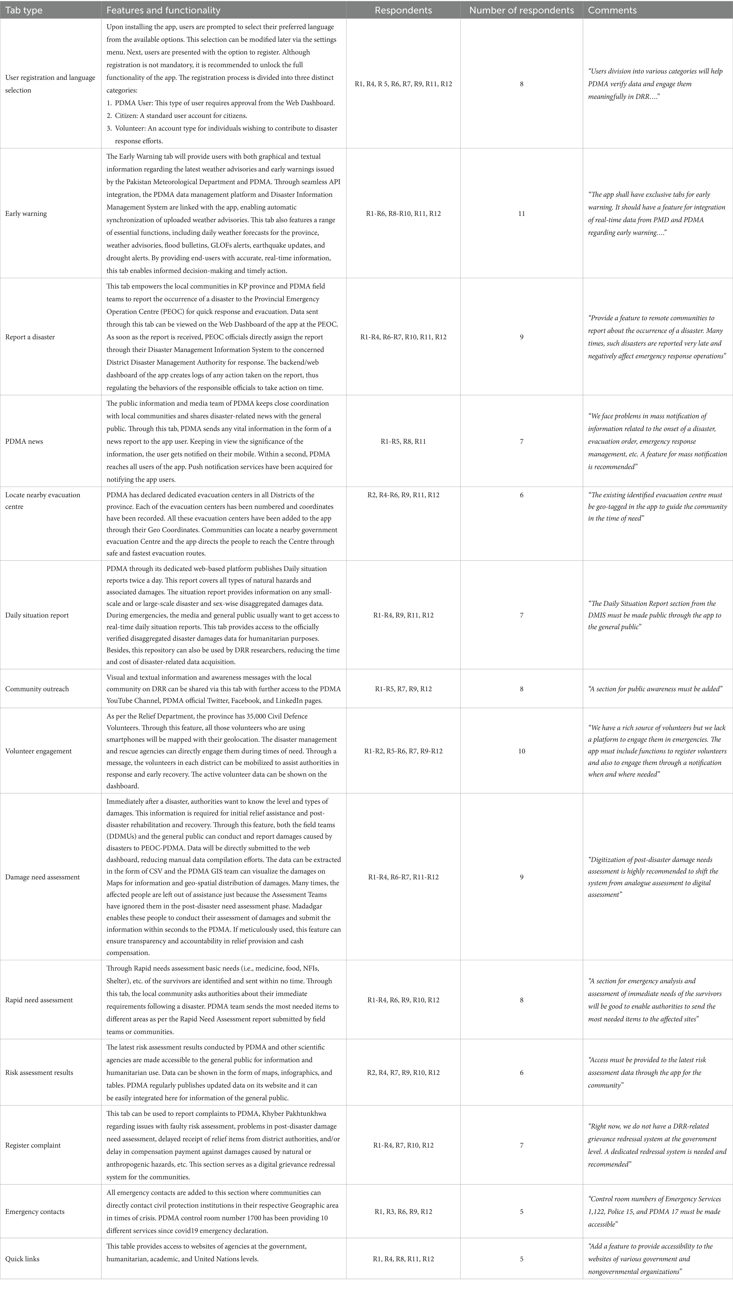
Table 5. Recommended features and functionality required in the PDMA Madadgar mobile application.
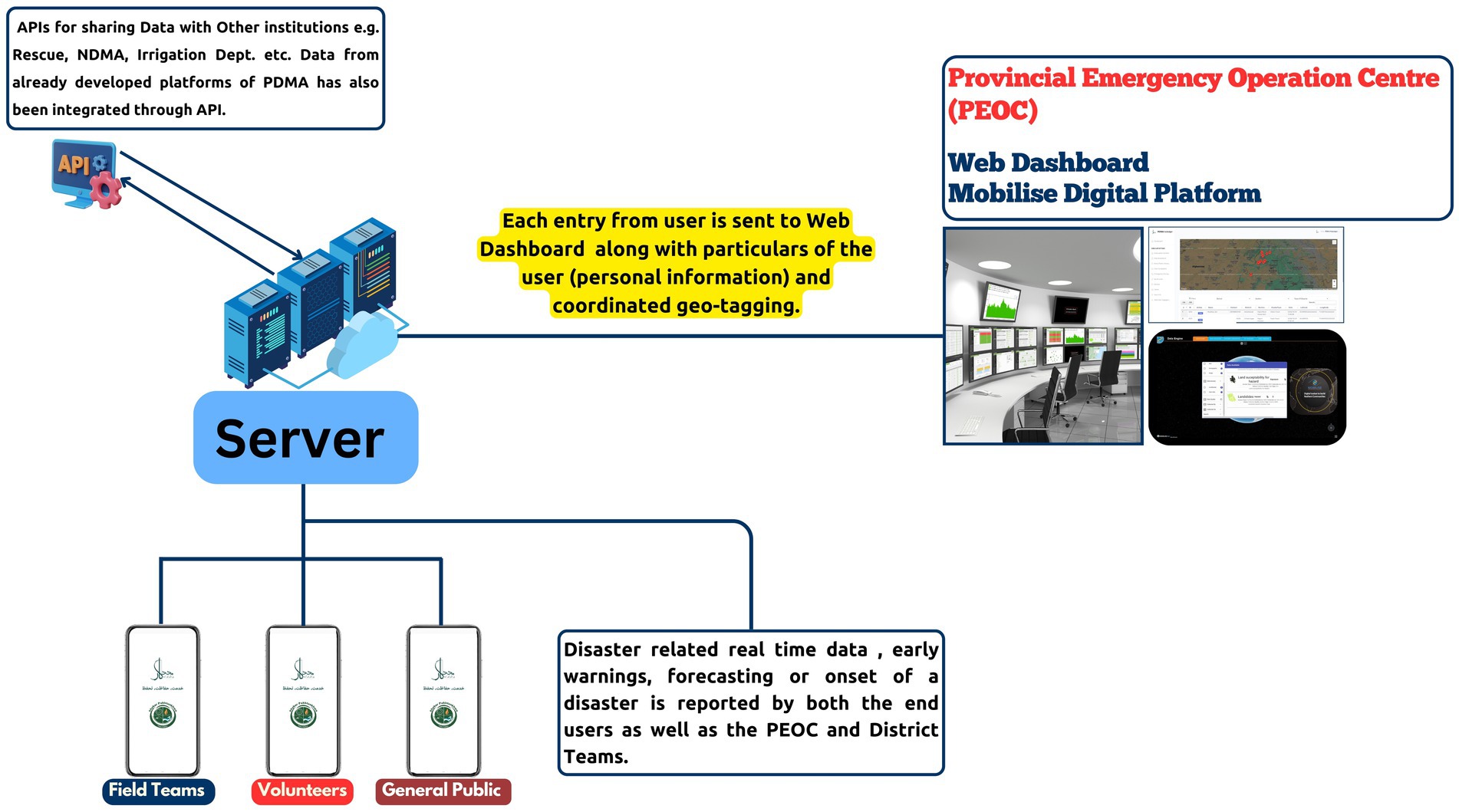
Figure 2. PDMA Madadgar App architecture (Reproduced from Jan et al. (2025) under CC BY).
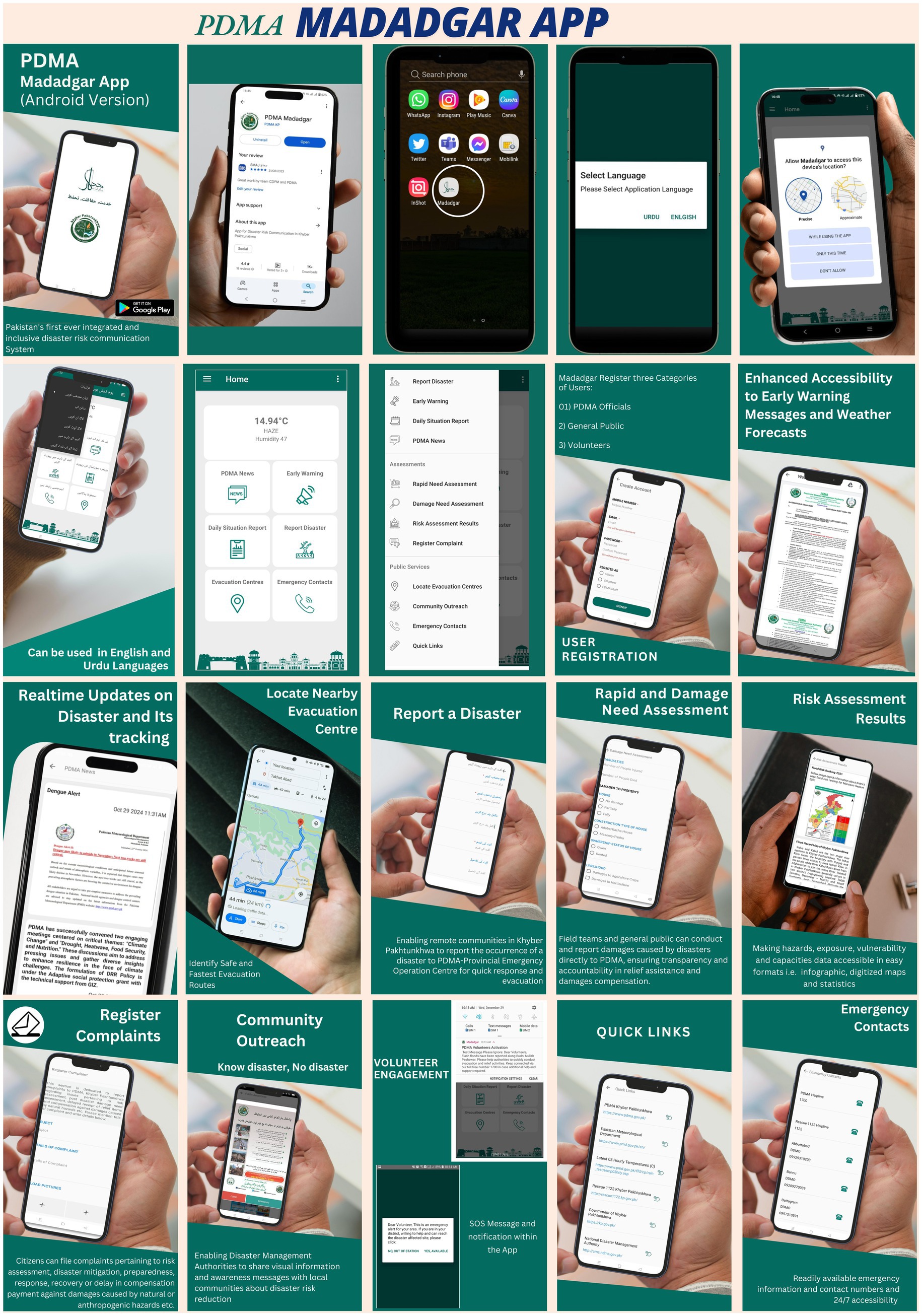
Figure 3. Visual overview of PDMA Madadgar App tabs (Adapted from Jan et al. (2025) under CC BY).
3.1 Material design, user Interface, language, and information sharing
In this section, the User Interface (UI), User Experience (UX), color scheme, language support, general features of the app and nature of the app has been discussed. The UI and UX were the technical aspects and only people from the IT section understood the questions related to it. The UI refers to the tabs, icons, screens, color palettes, fonts, dropdown menu, text fields, layout, and other visual elements of the Madadgar. UX is about the interaction one might have with the product, i.e., Madadgar app. It was recommended that the user interface must be adaptable as per the industry’s latest requirements. Data in Table 4 indicates that the majority of the research participants recommended using the color scheme of the PDMA logo (n = 9/12). Additional language support, i.e., Urdu along with English was highly recommended (n = 9/12). Research participants emphasized that the app must be interactive (n = 10/12). The interactive app allows the community to report back about a problem, the occurrence of a disaster, evacuation support, relief items needed, assessment of damages at both individual and community levels and engaging volunteers in times of need. Regarding the general features, the participants recommended that people are getting annoyed with too many apps for each aspect of DRR. Therefore, it was recommended to develop an app by integrating multiple components to make it easy for the community to use a single app with multiple functions (n = 10/12).
3.2 Recommended features, functionalities, and major tabs in the PDMA Madadgar app
Based on the data presented in Table 5, the results highlight several key features and functionalities recommendations for the Madadgar app. The feature with the highest number of participants’ support was the inclusion of an Early Warning tab (n = 11/12). Respondents emphasized the need for real-time data integration from the Pakistan Meteorological Department (PMD) and PDMA, including graphical and textual information on weather advisories, flood bulletins, GLOF alerts, earthquake updates and drought alerts. This underscores the critical importance of timely and accurate dissemination of early warning information for effective disaster preparedness and response.
Following closely, the Volunteer Engagement feature was supported by a significant majority of the research participants (n = 10/12). The research participants highlighted the availability of a large volunteer pool and the necessity of a platform to register and mobilize them during emergencies through geolocation mapping and notifications. Several features received support from 9/12 research participants, including Report a Disaster and Damage Need Assessment. The emphasis on the “Report a Disaster” feature centered around empowering local communities and PDMA field teams to report disaster occurrences to the Provincial Emergency Operation Centre (PEOC) for swift response and evacuation. For “Damage Need Assessment,” respondents recommended digitizing the process to ensure transparency and accountability in relief provision and cash compensation, with the ability for both field teams and the general public to conduct and report damages.
Other notable features and their support levels include User Registration and Language Selection (n = 8/12), Community Outreach (n = 8/12) and Rapid Need Assessment (n = 8/12). Seven out of 12 research participants supported the PDMA News, Daily Situation Report and Register Complaint sections. Six out of 12 research participants supported the Locate Nearby Evacuation Centre and sharing risk assessment results. Table 5 presents the data on the features of each function of Madadgar as well as the associated functionalities.
3.3 PDMA Madadgar App architecture
Figure 2 shows the architecture of the PDMA Madadgar App. During the validation workshop, the architecture was thoroughly discussed. Participants emphasized the interactive nature of the app. As per architecture, the app sends the data to the main server hosted on the database of the KP provincial government to ensure data privacy. A web dashboard of the backend is displayed at the PDMA-PEOC for quick response. Entries to the app are made by volunteers, district-level field teams, and the general public. Through APIs, data from other platforms have been integrated into the app. Public awareness messages, sharing any news, advisories, and volunteer engagement are administered from the web dashboard at the PEOC-PDMA. The app ensures two-way communication between users and PDMA. A push notification service has been enabled on the News and Early Warning tabs for sending any critical information to the user. Each entry from the app is sent to the dashboard via the server. A notification setting/siren on the web dashboard is catching the attention of PEOC staff for new entries. The web dashboard is also integrated with the Disaster Management Information System of the PDMA. This allows for real-time assignment of the reported problem to the concerned officers at the district level. The system creates logs for each report and action initiated on the information received from the users. This feature serves as a monitoring tool for the reports received from the communities and actions initiated. This regulates the behavior of the PEOC staff to respond to the concerns of the communities in time; otherwise, they can face disciplinary actions. During the validation workshop, concerns were raised regarding data protection and confidentiality and it was recommended to ensure a Secure Sockets Layer (SSL) certificate to secure communication and protect information from interception and eavesdropping.
4 Discussion
The data indicates that there are thirteen tabs in the Madadgar App, whereas some of the tabs are further divided into sub-tabs (Figure 3). For example, the early warning tab provides seven different types of information for different hazards and other atmospheric phenomena. As per the data, soon after the app installation, the user is prompted to language selection from the options of languages, i.e., English and Urdu. The user can change the language selection from the app settings. After language selection, the app directs the user to the user registration section. Although a user can be able to use the app without registration. But this restricts access to four functions of the app, i.e., Report a Disaster, Damages Need Assessment, Rapid Need Assessment, and Register Complaint. Through these tabs, communities can share information with PDMA and the authenticity of such data can only be assured when a user provides all personal relevant information. Three categories of users, i.e., PDMA users, Citizens, and Volunteers can log in and log out from the app in the app settings section. Registration is necessary for information sharing and the laws of Pakistan have punishment for people who circulate false warnings, share fake information, or claim compensation without damages (Ali and Iqbal, 2021).
The existing early warning system lacks a mechanism of feedback from society and a stake in information sharing. The information is usually generated at the federal level, whereas the disasters start at the local level (Rana et al., 2021). Besides, the country does not have meteorological stations in all districts, weakening the reliability of data to model the forecasts and issue advisories. During the flood of 2022, the authorities failed to communicate critical climate forecasts, including predictions of extreme summer 2022 rainfall in Pakistan, leaving the public uninformed and unprepared (Dunstone et al., 2023). In such a situation, Madadgar provides a comprehensive suite of features to augment response initiatives (Shafiq and Ahsan, 2014). The PDMA Madadgar App’s “Early Warning” tab provides access to early warning/advisories, daily weather reports, flood bulletin, GLOF alerts, the latest earthquake events and drought information. According to Jan et al. (2025), Madadgar empowers people across Khyber Pakhtunkhwa with crucial disaster information and communication. Users readily engage with its “Early Warning” feature, which delivers timely alerts, weather forecasts and hazard-specific advisories, enhancing their preparedness. The “Report a Disaster” tab in the Madadgar app empowers communities to directly report incidents to the PDMA-PEOC. This feature serves as a crucial counter-strategy to the traditional linear communication model, moving beyond unilateral announcements by authorities. It enables communities to add local, real-time information, including photos and location data to early warnings or disaster occurrences. This direct channel facilitates a rapid and precise emergency response, filling a critical gap where no prior digital mechanism for community-led reporting existed (Shah et al., 2023a).
The “PDMA News” section enables authorities to quickly disseminate any critical information to the app user. People also use the “PDMA News” section for essential updates on hazards and humanitarian aid. Another critical aspect of the app is the “Locating Nearby Evacuation Centres.” In emergencies, evacuation centers and routes serve as vital lifelines, providing a secure haven for individuals to seek refuge. By offering a protected environment, these centers ensure the safety and well-being of those affected, shielding them from harm (Suhardi et al., 2023). During the recent disasters in Pakistan, the existing early warning system remained irrelevant for many people and people faced serious evacuation challenges. For example, during the Murree snowstorm, the Punjab Disaster Management Authority did not convey the message to the public. The majority of the tourists were stranded in their vehicles and 22 precious lives were lost (Asad, 2022). The post-disaster investigation report of the government revealed that there was no evacuation mechanism, defined routes and/or evacuation centers (Geo News, 2022). A similar pattern was observed during the flood 2022 in the study area. The PDMA Madadgar App provides a list of all evacuation centers during an emergency, and with one click it directs people to the nearest evacuation centre using Google Maps services. The government has identified 179 evacuation centers in KP and it has been integrated with the Madadgar through their geo coordinates (Government of Khyber Pakhtunkhwa, 2022). The “Volunteer Engagement” section of Madadgar offers significant benefits. While the spirit of volunteerism is strong in the study area, a centralized platform to mobilize this crucial human resource has been lacking. The PDMA Madadgar app addresses this by enabling authorities to develop a roster of volunteers, assign tasks and communicate with them directly during times of need. All information shared through the app, including volunteer data and task assignments, seamlessly integrates with a web dashboard, ensuring efficient communication and response coordination between communities and the PDMA. The “Damage Need Assessment and Rapid Need Assessment” components enable the local people and local authorities to conduct these assessments with rapid submission to the authorities. The “Complaint Registration” section enables vulnerable people to file complaints in a digital mechanism and will serve as a grievance redressal system. Lastly, the emergency contacts of all critical social protection institutions are added to the app and the user can easily access these contact numbers when and wherever needed. According to Jan et al. (2025), Madadgar beta testing and evaluation results reveal that the key feature of the Madadgar received very positive ratings from its users (Early Warning 86.7%; Report Disaster 86.3%; PDMA News 66.6%; Evacuation Centres 73.3%; Register Complaint 76.6%; Damage Need Assessment 80% and Risk Assessment 66.7%).
Keeping in view gender sensitivity and inclusivity in Pakistan, Madadgar has been designed to incorporate features that empower vulnerable groups. This includes gender-sensitive reporting mechanisms that enable women in remote locations to actively participate in DRR operations, receive and disseminate early warnings and file complaints. The app also offers child-friendly content, such as age-appropriate alerts and visual guides in the public awareness section. Furthermore, accessibility features for the disabled, including multi-modal communication, screen reader compatibility and simplified navigation have been integrated. To address the digital divide, low-bandwidth optimization and extensive multilingual support ensure the app effectively reaches and empowers all segments of the population.
The results of the study strongly align with the multidimensional theoretical framework. The emphasis on features like two-way communication, community-led incident reporting and damage assessments directly reflects the principles of STS and PD frameworks. This highlights the crucial interplay between the app’s technical functionalities and the social structures, user engagement and local needs (Thomas, 2024; Kistenfeger et al., 2024; Messiha et al., 2023; Ahmad et al., 2022; Dell et al., 2021). The integration of various DRR components into a single app, along with the focus on user-friendly interfaces and multi-language support demonstrates an understanding of DOI theory, aiming to increase the app’s relative advantage, compatibility and trialability for broader adoption (Mbatha, 2024; Shaw et al., 2022; Frei-Landau et al., 2022; Call and Herber, 2022). Furthermore, the detailed architecture which outlines the roles of various “actants” ranging from PDMA officials and app developers to community members, smartphones and hazards shows the practical application of ANT in mapping the complex network essential for Madadgar’s successful conceptualization and deployment, ensuring all elements, human and non-human contribute to its functionality and impact (Lin and Yang, 2021; Singgalen, 2021).
The PDMA Madadgar app stands apart from conventional disaster-related applications by offering a comprehensive, interactive, and localized operational tool for DRR. Unlike global monitoring platforms, specialized weather apps, first-aid guides or national alert systems, Madadgar uniquely integrates multi-hazard early warnings with extensive localized support services (like evacuation center directories, volunteer management and grievance redressal). Its deep integration with the PDMA’s operational backend via a web dashboard creates an actionable framework for disaster risk reduction, response and recovery, bridging the citizen-authority gap by empowering communities with bidirectional reporting capabilities and facilitating coordinated institutional responses. A detailed comparative analysis of the Madadgar with other such apps has been presented in Table 6.
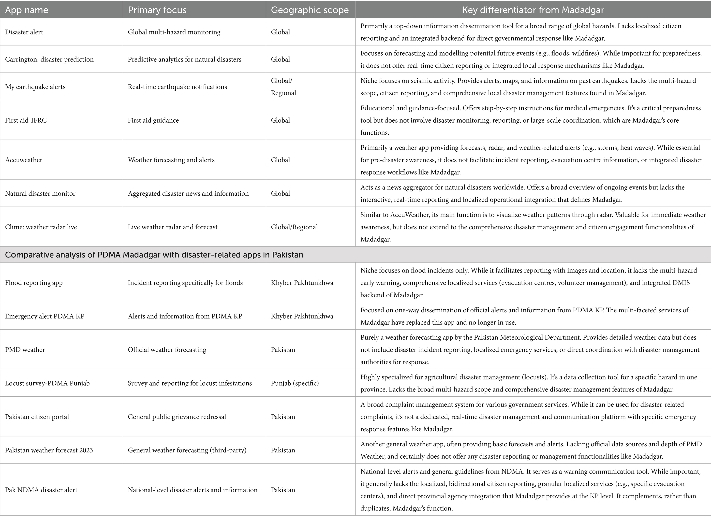
Table 6. Comparative Analysis of PDMA Madadgar with Other Apps.
Madadgar conceptual model also has a few major limitations, i.e., data privacy, connectivity issues and user adoption. The data privacy and security limitations were effectively mitigated through stakeholder engagement and participatory design to embed user-centric privacy features. The clear privacy policy and robust technical measures like data minimization, informed consent, SSL/TLS encryption, strong authentication, secure storage and regular dependency updates has further reduced the privacy concerns (Jan et al., 2025; PDMA, 2023). The inherent challenge of connectivity in remote disaster-prone areas is also recognized; while the app optimizes digital communication where infrastructure exists, Madadgar next next-generation model will explore complementary solutions such as offline capabilities or integration of alternative communication channels to bridge this digital divide. To achieve widespread and sustained user adoption and accessibility considering varying literacy and digital skills, an ongoing user experience study has already been initiated along with localized training, social media content, videos and targeted strategies to ensure inclusivity. Based on the results of the upcoming adoption potential study with a large sample size in all seven administrative divisions of KP, we will provide a concept of a next-generation model of the Madadgar. In the next generation, we will move beyond real-time alerts and explore predictive analytics (Machine Learning), automated risk assessments (Artificial Intelligence) and personalized notifications for a more proactive and intelligent app aligning with the long-term vision for the Madadgar App.
The Madadgar app has significant policy implications, serving as a practical model for strengthening disaster risk communication in Pakistan and other developing countries. The app directly contributes to the Pakistan National Disaster Management Act 2010 (articles 16-2 J, 20-2 K), which explicitly emphasizes the use of information and communication technologies to enhance early warning capabilities and build resilience through preparedness (Government of Pakistan, 2010). By providing a platform for real-time alerts, two-way communication and citizen reporting, the app operationalizes these policy directives at the grassroots level, transforming abstract policy goals into actionable tools. Madadgar closely aligns with the Pakistan National DRR Policy by operationalizing its focus on enhancing early warning systems, promoting community participation and utilizing technology for effective communication and information sharing to build national and local resilience against disasters (Government of Pakistan, 2013). Furthermore, Madadgar aligns with global agendas like the Sendai Framework for DRR 2015–2030 and contributes to SDGs 11, 13, and 17 (IPU and UNDRR, 2021; UNDRR, 2015) (573–586).
The Madadgar App presents a robust, scalable blueprint for enhancing disaster risk communication in developing countries due to its ability to address common vulnerabilities like weak early warnings and the digital divide. Madadgar transforms passive users into active DRR participants through two-way communication, integrates multiple DRR functions into a user-friendly app, prioritizes local context and language, and boosts governance and accountability via integration with official systems like PDMA’s DMIS. Madadgar codes and algorithms have been made public for replication in other areas on a humanitarian basis and can be reached at Syedpg (2025).
5 Conclusion
The conceptual model of the PDMA Madadgar App indicates that it is a critical tool for enhancing disaster resilience in KP, Pakistan. Featuring an intuitive and user-friendly interface, the Madadgar enables local communities to report disaster incidents in real-time, access timely early warning messages, and conduct comprehensive post-disaster assessments. The app’s multifaceted features, including instantaneous incident reporting, proactive early warning systems, volunteer mobilization, evacuation centers localization, and assessment and complaint registration effectively address the challenges in Pakistan’s early warning system and disaster response mechanisms. Specifically, it addresses the limitations of Pakistan’s early warning system, which often fails to communicate critical information to the public. The app enhances disaster preparedness, response, and resilience in Pakistan. Its impact will be crucial in saving lives and reducing damage during disasters. By facilitating useful information dissemination and effective response, the app strengthens disaster risk communication in Pakistan, expediting widespread adoption through its bilingual language options. The development and implementation of the PDMA Madadgar App have the potential to transform the way disasters are managed in KP, Pakistan. By leveraging technology and community engagement, the app can help mitigate the impact of disasters, save lives, and foster sustainable development. PDMA Madadgar App is accessible on the Google Play Store via https://play.google.com/store/apps/details?id=com.mobilisepakistanirfan.pdma.
Data availability statement
The datasets presented in this article are publicly available on GitHub and can be accessed via Frontend (App) Code: https://github.com/irfansyedpg/AndroidCP Backend (Dashboard) Code: https://github.com/irfansyedpg/madadgar. Further inquiries can be directed to the corresponding author.
Ethics statement
The study adhered to all applicable local legislation and the ethical guidelines. All research participants provided their written informed consent, having been fully apprised of the study’s purpose, procedures, potential risks and their right to withdraw at any time.
Author contributions
MJ: Conceptualization, Writing – original draft, Formal analysis. SIU: Writing – original draft, Data curation, Methodology. WU: Writing – review & editing, Visualization, Investigation, Funding acquisition. SU: Investigation, Writing – review & editing, Formal analysis. HT: Supervision, Writing – original draft, Validation. TF: Writing – review & editing, Project administration, Funding acquisition. AA: Supervision, Resources, Writing – review & editing, Investigation. ZR: Visualization, Validation, Writing – review & editing.
Funding
The author(s) declare that financial support was received for the research and/or publication of this article. The authors express their gratitude to the Global Challenges Research Fund (GCRF) and the Engineering and Physical Sciences Research Council (EPSRC) for the support under the International Grant, EP/PO28543/1, entitled “A Collaborative Multi-Agency Platform for Building Resilient Communities” and the GCRF and the Economic and Social Research Council (ESRC) support under the Grant ES/T003219/1 entitled “Technology Enhanced Stakeholder Collaboration for Supporting Risk-Sensitive Sustainable Urban Development”. The authors acknowledge Rabdan Academy, United Arab Emirates (UAE) for supporting article processing charges (APC).
Conflict of interest
The authors declare that the research was conducted in the absence of any commercial or financial relationships that could be construed as a potential conflict of interest.
Generative AI statement
The authors declare that no Gen AI was used in the creation of this manuscript.
Publisher’s note
All claims expressed in this article are solely those of the authors and do not necessarily represent those of their affiliated organizations, or those of the publisher, the editors and the reviewers. Any product that may be evaluated in this article, or claim that may be made by its manufacturer, is not guaranteed or endorsed by the publisher.
References
Abunyewah, M., Gajendran, T., Maund, K., and Okyere, S. A. (2020). Strengthening the information deficit model for disaster preparedness: mediating and moderating effects of community participation. Int. J. Disaster Risk Reduct. 46:101492. doi: 10.1016/j.ijdrr.2020.101492
AccuWeather (2012) AccuWeather: Weather Radar. Google Play App Store (Version 20.4-6-google) [Mobile app]. Available online at: https://play.google.com/store/apps/details?id=com.accuweather.android&hl=en&gl=US (Accessed July 6, 2024).
Ahmad, A., Whitworth, B., and Bertino, E. (2022). A framework for the application of socio-technical design methodology. Ethics Inf. Technol. 24:46. doi: 10.1007/s10676-022-09651-0
Ali, A., and Iqbal, M. J. (2021). National Disaster Management act, 2010 of Pakistan: a review. J. Disaster Emerg. Res. 4, 52–59. doi: 10.18502/jder.5810
Ali, A., Rana, I. A., Ali, A., and Najam, F. A. (2022). Flood risk perception and communication: the role of hazard proximity. J. Environ. Manag. 316:115309. doi: 10.1016/j.jenvman.2022.115309
Ali, A., Ullah, W., Khan, U. A., Ullah, S., Ali, A., Jan, M. A., et al. (2024). Assessment of multi-components and sectoral vulnerability to urban floods in Peshawar – Pakistan. Nat. Hazards Res. 4, 507–519. doi: 10.1016/j.nhres.2023.12.012
Ali, F., Zhang, J. H., Alam, M., Meer, Sajjad, Abbas, S., Hussain, A., et al. (2023). Avalanche susceptibility mapping of district Shigar, Pakistan using GIS-based MCDA–AHP modeling. Available online at: https://ouci.dntb.gov.ua/en/works/7XGJWWq9/ (Accessed July 6, 2024).
Ali, N., Alam, A., Bhat, M. S., and Shah, B. (2022). Using historical data for developing a hazard and disaster profile of the Kashmir valley for the period 1900–2020. Nat. Hazards 114, 1609–1646. doi: 10.1007/s11069-022-05440-6
Anis, F., and Ashfaq, A. (2023). Role of digital Media in Disaster Management: a case of Khyber Pakhtunkhwa Pakistan. J. Dev. Soc. Sci. 4:48. doi: 10.47205/jdss.2023(4-i)48
Asad, S. (2022). The Murree tragedy: exploring the reasons of a deadly situation. PakistanToday. Available online at: https://www.pakistantoday.com.pk/2022/01/24/the-murree-tragedy-exploring-the-reasons-of-a-deadly-situation/ (Accessed September 6, 2024).
Atta-Ur-Rahman, K., and Khan, A. N. (2013). Analysis of 2010-flood causes, nature and magnitude in the Khyber Pakhtunkhwa, Pakistan. Nat. Hazards 66, 887–904. doi: 10.1007/s11069-012-0528-3
Call, D. R., and Herber, D. R. (2022). Applicability of the diffusion of innovation theory to accelerate model-based systems engineering adoption. Syst. Eng. 25, 574–583. doi: 10.1002/sys.21638
Carstensen, A.-K., and Bernhard, J. (2019). Design science research – a powerful tool for improving methods in engineering education research. Eur. J. Eng. Educ. 44, 85–102. doi: 10.1080/03043797.2018.1498459
Cheema, S. M. (2023). Relationship among safety, quality and productivity in construction projects. J. Deve. Soc. Sci. 4, 183–193. doi: 10.47205/jdss.2023(4-I)17
Dell, N. A., Maynard, B. R., Murphy, A. M., and Stewart, M. (2021). Technology for research synthesis: An application of sociotechnical systems theory. J. Soc. Social. Work Res. 12, 201–222. doi: 10.1086/713525
Dominac925 (2012). Natural Disaster Monitor (Version 5.9.101) [Mobile app]. Available online at: https://play.google.com/store/apps/details?id=com.dom925.disastermon&hl=en&gl=US (Accessed September 6, 2024).
Dunstone, N., Smith, D. M., Hardiman, S. C., Davies, P., Ineson, S., Jain, S., et al. (2023). Windows of opportunity for predicting seasonal climate extremes highlighted by the Pakistan floods of 2022. Nat. Commun. 14:6544. doi: 10.1038/s41467-023-42377-1
Esposito, M., Palma, L., Belli, A., Sabbatini, L., and Pierleoni, P. (2022). Recent advances in internet of things solutions for early warning systems: a review. Sensors 22:124. doi: 10.3390/s22062124
Fan, C., Zhang, C., Yahja, A., and Mostafavi, A. (2021). Disaster City Digital Twin: A Vision for Integrating Artificial and Human Intelligence for Disaster Management. Int. J. Inform. Manag. 2021, 1–37. doi: 10.1016/j.ijinfomgt.2019.102049
Fahad, S., and Wang, J. (2020). Climate change, vulnerability, and its in rural Pakistan: a review. Environmental Science and Pollution Research. 27, 1334–1338. doi: 10.1007/s11356-019-06878-1
Frei-Landau, R., Muchnik-Rozanov, Y., and Avidov-Ungar, O. (2022). Using Rogers’ diffusion of innovation theory to conceptualize the mobile-learning adoption process in teacher education in the COVID-19 era. Educ. Inf. Technol. 27, 12811–12838. doi: 10.1007/s10639-022-11148-8
Gardezi, H., Bilal, M., Cheng, Q., Xing, A., Zhuang, Y., and Masood, T. (2021). A comparative analysis of attabad landslide on january 4, 2010, using two numerical models. Nat. Hazards 107, 519–538. doi: 10.1007/s11069-021-04593-0
Geo News (2022). What does the Murree inquiry report say? Available online at: https://www.geo.tv/latest/394470-what-does-the-murree-inquiry-report-say (Accessed September 9, 2024).
Government of Khyber Pakhtunkhwa (2014). The Khyber Pakhtunkhwa emergency rescue services (amendment) act (act no. XXXIX of 2014). Available online at: http://www.pakp.gov.pk/2013/wp-content/uploads/Emergency-Rescue-Services-Amendment-Act-2014.pdf (Accessed July 8, 2024).
Government of Khyber Pakhtunkhwa (2022). Evacuation and Pre Camp Sites. Pesahwar. Available online at: https://www.pdma.gov.pk/Camp-management (Accessed September 9, 2024).
Government of Pakistan (2010). National Disaster Management act 2010. Islamabad: National Assembly of Pakistan.
Government of Pakistan (2013). National Disaster Risk Reduction Policy. Islamabad: Government of Pakistan.
Government of Pakistan (2021). Pakistan social and living standards measurement survey. Islamabad. Available online at: https://www.pbs.gov.pk/publication/pakistan-social-and-living-standards-measurement-survey-pslm-2019-20-provincial (Accessed October 27, 2024).
Government of Pakistan (2024a) Annual Mobile Cellular Subscribers. Available online at: https://pta.gov.pk/en/telecom-indicators/1 (Accessed September 6, 2024).
Government of Pakistan (2024b). National Disaster Management Plan III. Islamabad. Available online at: http://www.ndma.gov.pk/storage/plans/July2024/vWxklzviXxzbgPGHuitB.pdf (Accessed December 28, 2024).
Huseynli, M., Bub, U., and Ogbuachi, M. C. (2022). Development of a method for the engineering of digital innovation using design science research. Information 13:573. doi: 10.3390/info13120573
Hussain, M. A., Shuai, Z., Moawwez, M. A., Umar, T., Iqbal, M. R., Kamran, M., et al. (2023a). A review of spatial variations of multiple natural hazards and risk management strategies in Pakistan. Water 15:407. doi: 10.3390/w15030407
Hussain, M. A., Tayyab, M., Ullah, K., Ullah, S., Rahman, Z. U., Zhang, J., et al. (2023b). Development of a new integrated flood resilience model using machine learning with GIS-based multi-criteria decision analysis. Urban Clim. 50:101589. doi: 10.1016/j.uclim.2023.101589
International Federation of Red Cross and Red Crescent Societies (2018). First Aid-IFRC (Version 4.0.2) [Mobile app]. Google Play Store. Available online at: https://play.google.com/store/apps/details?id=com.cube.gdpc.fa&hl=en&gl=US (Accessed December 28, 2024).
IPU and UNDRR (2021). Disaster risk reduction to achieve the sustainable development goals. Geneva. Available at: https://www.undrr.org/media/74220/download?startDownload=20250705 (Accessed July 6, 2025).
I-SAP (2010). Floods 2010: disaster Risk Management-Legal Framework, Issues and Challenges. Available online at: http://i-saps.org/upload/report_publications/docs/1401030390.pdf (Accessed November 16, 2024).
Jan, M. A. (2018). Training report: first three day training on flood management through flood forecasting and early warning system. Peshawar: Centre for Disaster Preparedness and Management and UNESCO.
Jan, M. A., and Ahmed, K. (2018). Institutional mapping and collaboration platforms for disaster Management in Pakistan: a case study. Peshawar: Centre for Disaster Preparedness and Management.
Jan, M. A., and Muhammad, N. (2020). Governance and disaster vulnerability reduction: a community based perception study in Pakistan. Available online at: https://innspub.net/governance-and-disaster-vulnerability-reduction-a-community-based-perception-study-in-pakistan/ (Accessed May 25, 2025).
Jan, M. A., Mujahid, D., and Shahab, M. (2019). MOBILISE expo on technology mediated disaster risk reduction, climate change adaptation and sustainable development. Available online at: https://mobilise-project.org.uk/documents/ExpoReport.pdf (Accessed September 6, 2024).
Jan, M. A., Ullah, S. I., Ullah, W., Ullah, S., Ali, A., Tariq, H., et al. (2025). Testing and evaluation of Pakistan’s pioneer disaster risk communication app: a case study of PDMA Madadgar android-based app. Front. Commun. 10:1572206. doi: 10.3389/fcomm.2025.1572206
Jat, A. S., Grønli, T.-M., and Ghinea, G. (2024). Navigating design science research in mHealth applications: a guide to best practices. IEEE Trans. Eng. Manag. 71, 14472–14484. doi: 10.1109/TEM.2024.3450178
Javed Khan, K., Bano, Z., and Ur Rahman, S. (2019). Nexus of social and technological approaches to floods early warning system (EWS) in disaster risk management. Int. J. Sci. Eng. Res. 10, 928–939.
Javeid, U., Pratt, S., Li, H., and Zhao, G. (2023). The effect of terrorism on continuing education: evidence from Pakistan. Educ. Econ. 31, 376–396. doi: 10.1080/09645292.2022.2073584
JRustonApps B.V (2015). My earthquake alerts (version 5.6.0) [Mobile app]. Google play store. Available online at: https://play.google.com/store/apps/details?id=com.jrustonapps.myearthquakealerts&hl=en&gl=US (Accessed July 24, 2024).
Khan, A. A., Rana, I. A., Nawaz, A., and Waheed, A. (2021). Gender-based emergency preparedness and awareness: empirical evidences from high-school students of Gilgit, Pakistan. Environ. Hazards 20, 416–431. doi: 10.1080/17477891.2020.1839375
Khan, A., Gupta, S., and Gupta, S. K. (2020). Multi-hazard disaster studies: monitoring, detection, recovery, and management, based on emerging technologies and optimal techniques. Int. J. Disaster Risk Reduct. 47:101642. doi: 10.1016/j.ijdrr.2020.101642
Khan, I., Ali, A., Ullah, W., Jan, M. A., Ullah, S., Laker, F. A., et al. (2024). Mainstreaming disaster risk reduction (DRR) into development: effectiveness of DRR investment in Khyber Pakhtunkhwa, Pakistan. Front. Environ. Sci. 12:1474344. doi: 10.3389/fenvs.2024.1474344
Khan, I., Ali, A., Waqas, T., Ullah, S., Ullah, S., Shah, A. A., et al. (2022). Investing in disaster relief and recovery: a reactive approach of disaster management in Pakistan. Int. J. Disaster Risk Reduct. 75:102975. doi: 10.1016/j.ijdrr.2022.102975
Khan, I., Saqib, M., and Hafidi, H. (2021). Poverty and environmental nexus in rural Pakistan: a multidimensional approach. GeoJournal 86, 663–677. doi: 10.1007/s10708-019-10090-6
Khan, I., Waqas, T., Samiullah,, and Ullah, S. (2020). Precipitation variability and its trend detection for monitoring of drought hazard in northern mountainous region of Pakistan. Arab J Geosci. 13:698. doi: 10.1007/s12517-020-05700-4
Khan, M., Imtiaz, S., Parvaiz, G. S., Hussain, A., and Bae, J. (2021). Integration of internet-of-things with blockchain technology to enhance humanitarian logistics performance. IEEE Access 9, 25422–25436. doi: 10.1109/ACCESS.2021.3054771
Khan, M., Parvaiz, G. S., Ali, A., Jehangir, M., Hassan, N., and Bae, J. (2022). A model for understanding the mediating Association of Transparency between emerging technologies and humanitarian logistics sustainability. Sustainability 14:6917. doi: 10.3390/su14116917
Khayyam, U., and Noureen, S. (2020). Assessing the adverse effects of flooding for the livelihood of the poor and the level of external response: a case study of Hazara division, Pakistan. Environ. Sci. Pollut. Res. 27, 19638–19649. doi: 10.1007/s11356-020-08303-4
Khyber Pakhtunkhwa Information Technology Board (2022). Flood Reporting App (Version 1.0.0) [Mobile app]. Google Play Store. Available online at: https://play.google.com/store/apps/details?id=com.kpfloodreporting.kpitb&hl=en_US (Accessed July 25, 2024).
Kistenfeger, J., Schmidtke, S., and Dittmar, A. (2024). Designing a local “climate app.”, in Proceedings of the European conference on cognitive ergonomics 2024, (New York, NY, USA: ACM), 1–4.
Koepp, J., Baron, M. V., Kipper, L. M., Carneiro, M., Gaedke, M. Â., Possuelo, L. G., et al. (2024). Development of an application in the healthcare area using the design science research methodology. Caderno Pedag. 21, 1261–1280. doi: 10.54033/cadpedv21n1-066
Lidiawaty, B. R., Nasution, A. H., Putra, A. R., and Tjahyanto, A. (2024). Design science research for developing risk tourism mapping based on visitor sentiment review. Proc. Comput. Sci. 234, 1672–1680. doi: 10.1016/j.procs.2024.03.172
Lin, Z., and Yang, L. (2021). Smartphones as actors: a new digital disability care actor-network in China. Int. J. Cult. Stud. 24, 673–688. doi: 10.1177/1367877920964475
Manzoor, Z., Ehsan, M., Khan, M. B., Manzoor, A., Akhter, M. M., Sohail, M. T., et al. (2022). Floods and flood management and its socio-economic impact on Pakistan: a review of the empirical literature. Front. Environ. Sci. 10:1021862. doi: 10.3389/fenvs.2022.1021862
Mauka, W., Mbotwa, C., Moen, K., Lichtwarck, H. O., Haaland, I., Kazaura, M., et al. (2021). Development of a Mobile health application for HIV prevention among at-risk populations in urban settings in East Africa: a participatory design approach. JMIR Form Res. 5:e23204. doi: 10.2196/23204
Mbatha, B. (2024). “Diffusion of Innovations: How Adoption of New Technology Spreads in Society” in Information, Knowledge, and Technology for Teaching and Research in Africa. Synthesis lectures on information concepts, retrieval, and services. eds. D. Ocholla, O. B. Onyancha, and A. O. Adesina (Cham: Springer), 1–18.
Memon, M. H. (2023). Poverty, gap and severity estimates for disaster prone rural areas of Pakistan. Soc. Indic. Res. 166, 645–663. doi: 10.1007/s11205-023-03082-0
Meo, M. Z. S., Meo, M. O. S., and Meo, A. S. (2022). Snowfall and carbon monoxide poisoning in Murree Pakistan. Pak J. Med. Sci. 38:2386. doi: 10.12669/pjms.38.8.6936
Messiha, K., Chinapaw, M. J. M., Ket, H. C. F. F., An, Q., Anand-Kumar, V., Longworth, G. R., et al. (2023). Systematic review of contemporary theories used for co-creation, co-design and co-production in public health. J. Public Health 45, 723–737. doi: 10.1093/pubmed/fdad046
Mobile Heroes (2016). Clime: Weather Radar Live (Version 1.72.7) [Mobile app]. Available online at: https://play.google.com/store/apps/details?id=com.apalon.weatherradar.free (Accessed December 28, 2024).
Mobilise Project Team-Pakistan (2018). Workshop on Multi-Agency Collaboration for Disaster Management in Pakistan. Peshawar. Available online at: https://mobilise-project.org.uk/documents/Mobilise_Workshop_Report-October_17_2018.pdf (Accessed September 6, 2024).
Nanditha, J. S., Kushwaha, A. P., Singh, R., Malik, I., Solanki, H., Chuphal, D. S., et al. (2023). The Pakistan flood of august 2022: causes and implications. Earths. Future 11:e2022EF003230. doi: 10.1029/2022EF003230
NDMA (2012). National Multi-Hazard Early Warning System Plan: Volum II. Islamabad: National Disaster Manaagement Authority.
NDMA (2024). Pak NDMA Disaster Alert (Version 1.18). Available at: https://play.google.com/store/apps/details?id=com.mobileapp.ndmaalert (Accessed December 29, 2024).
Otto, F. E. L., Zachariah, M., Saeed, F., Siddiqi, A., Kamil, S., Mushtaq, H., et al. (2023). Climate change increased extreme monsoon rainfall, flooding highly vulnerable communities in Pakistan. Environ. Res. 2:25001. doi: 10.1088/2752-5295/acbfd5
Pacific Disaster Centre (2011). Disaster Alert (Version 7.5.5) [Mobile app]. Google Play Store. Available online at: https://play.google.com/store/apps/details?id=disasterAlert.PDC&hl=en&gl=US (Accessed September 6, 2024).
Pakistan Meteorological Department (2021) PMD Weather App (Version 1.5.1) [Mobile app]. Google Play Store. Available online at: https://play.google.com/store/apps/details?id=pmd.gov.pakistanweather&hl=en&gl=US#:~:text=About%20this%20app&text=This%20is%20the%20official%20weather,weather%20forecasting%20center%20in%20Pakistan (Accessed July 6, 2024).
PDMA (2023). PDMA Madadgar. Available online at: https://play.google.com/store/apps/details?id=com.mobilisepakistanirfan.pdma (Accessed July 26, 2025).
PDMA (2025). Daily Situation Report Pesahwar. Available online at: https://rms.pdma.gov.pk/ViewDSR.aspx?DSRID=7312 (Accessed July 4, 2025).
Prime Minister’s Performance Delivery Unit (2018). Pakistan Citizen Portal (Version 3.2.29) [Mobile app]. Google Play Store. Available at: https://play.google.com/store/apps/details?id=com.govpk.citizensportal&hl=en&gl=US (Accessed April 24, 2024).
Provincial Disaster Management Authority. (2018). Emergency Alert PDMA KP (Version 1.28) [Mobile app]. Google Play Store. Available at: https://play.google.com/store/apps/details?id=com.pdma.fasihims.emergencyalertpdmakp&hl=gsw&gl=US (Accessed September 6, 2024).
Provincial Disaster Management Authority (2021). Locust survey-PDMA Punjab (version 1.5.1) [Mobile app]. Google Play Store. Lahore: PDMA.
Qureshi, J. A., Khan, G., Ali, N., Ali, S., Ur Rehman, S., Bano, R., et al. (2022). Spatio-temporal change of glacier surging and glacier-dammed Lake formation in Karakoram Pakistan. Earth Syst. Environ. 6, 249–262. doi: 10.1007/s41748-021-00264-z
Rana, I. A., Bhatti, S. S., and Jamshed, A. (2021). Effectiveness of flood early warning system from the perspective of experts and three affected communities in urban areas of Pakistan. Environ. Hazards 20, 209–228. doi: 10.1080/17477891.2020.1751031
RESE’ LLC (2015). Corrington: Disaster Prediction App (Version 5.9.8) [Mobile app]. Google Play Store. Available online at: https://play.google.com/store/apps/details?id=com.disasterprediction.ios&hl=en&gl=US (Accessed September 6, 2024).
Ryan, T., Ryan, N., and Hynes, B. (2024). The integration of human and non-human actors to advance healthcare delivery: unpacking the role of actor-network theory, a systematic literature review. BMC Health Serv. Res. 24:1342. doi: 10.1186/s12913-024-11866-4
Saif, B., Tahir, M., Sultan, A., Iqbal, M. T., Iqbal, T., Shah, M. A., et al. (2022). Triggering mechanisms of Gayari avalanche, Pakistan. Nat. Hazards 112, 2361–2383. doi: 10.1007/s11069-022-05269-z
Sajida Tufail, S., and Ainuddin, S. (2016). Assessing the role of information and communication technologies (ICTs) in Disaster Management of Balochistan Social Sciences. Quetta: Management of Balochistan. Unpublished Masters thesis, University of Baluchistan.
Sarker, M. N. I., Peng, Y., Yiran, C., and Shouse, R. C. (2020). Disaster resilience through big data: way to environmental sustainability. Int. J. Disaster Risk Reduct. 51:101769. doi: 10.1016/j.ijdrr.2020.101769
Shafiq, F., and Ahsan, K. (2014). An ICT based early warning system for flood disasters in Pakistan. Available online at: https://www.researchgate.net/profile/Farhan-Shafiq/publication/271192272_An_ICT_based_Early_Warning_System_for_Flood_Disasters_in_Pakistan/links/5788c59008ae378efdda3119/An-ICT-based-Early-Warning-System-for-Flood-Disasters-in-Pakistan.pdf (Accessed September 8, 2024).
Shah, A. A., Ullah, A., Khan, N. A., Khan, A., Tariq, M. A. U. R., and Xu, C. (2023a). Community social barriers to non-technical aspects of flood early warning systems and NGO-led interventions: the case of Pakistan. Front. Earth Sci. 11, 1–15. doi: 10.3389/feart.2023.1068721
Shah, A. A., Ullah, A., Khan, N. A., Shah, M. H., Ahmed, R., Hassan, S. T., et al. (2023b). Identifying obstacles encountered at different stages of the disaster management cycle (DMC) and its implications for rural flooding in Pakistan. Front. Environ. Sci. 11:1088126. doi: 10.3389/fenvs.2023.1088126
Shah, I., Elahi, N., Alam, A., Dawar, S., and Dogar, A. A. (2020). Institutional arrangement for disaster risk management: evidence from Pakistan. Int. J. Disaster Risk Reduct. 51:101784. doi: 10.1016/j.ijdrr.2020.101784
Shah, S. M. H., Mustaffa, Z., Teo, F. Y., Imam, M. A. H., Yusof, K. W., and Al-Qadami, E. H. H. (2020). A review of the flood hazard and risk management in the south Asian region, particularly Pakistan. Sci. Afr. 10:e00651. doi: 10.1016/j.sciaf.2020.e00651
Shaikh, S., Brown, A., and Enegbuma, W. I. (2023). The role of disaster knowledge management in improving housing reconstruction outcomes: with particular reference to Postearthquake reconstruction in Pakistan. Int. J. Disaster Resil. Built Environ. 14, 314–331. doi: 10.1108/IJDRBE-07-2021-0074
Shaw, N., Eschenbrenner, B., and Brand, B. M. (2022). Towards a Mobile app diffusion of innovations model: a multinational study of mobile wallet adoption. J. Retail. Consum. Serv. 64:102768. doi: 10.1016/j.jretconser.2021.102768
Shehzad, K. (2023). Extreme flood in Pakistan: is Pakistan paying the cost of climate change? A short communication. Sci. Total Environ. 880:162973. doi: 10.1016/j.scitotenv.2023.162973
Singgalen, Y. A. (2021). Actor-network theory and sentiment analysis on regional development issues and politics in social media. J. Komunikasi 13:89. doi: 10.24912/jk.v13i1.9627
Social and Meltwater (2023). Digital 2023: Pakistan. Available online at: https://datareportal.com/reports/digital-2023-pakistan (Accessed September 6, 2024).
Steinke, J., Ortiz-Crespo, B., van Etten, J., and Müller, A. (2022). Participatory design of digital innovation in agricultural research-for-development: insights from practice. Agric. Syst. 195:103313. doi: 10.1016/j.agsy.2021.103313
Stute, M., Maass, M., Schons, T., Kaufhold, M.-A., Reuter, C., and Hollick, M. (2020). Empirical insights for designing information and communication Technology for International Disaster Response. Int. J. Disaster Risk Reduct. 47:101598. doi: 10.1016/j.ijdrr.2020.101598
Su, X., Zhang, Y., Meng, X., Rehman, M. U., Khalid, Z., and Yue, D. (2022). Updating inventory, deformation, and development characteristics of landslides in Hunza Valley, NW Karakoram Pakistan by SBAS-InSAR. Remote Sens. 14:907. doi: 10.3390/rs14194907
Suhardi, A., Samsuddin, I., and Ismail, D. (2023). Developing resilient design criteria for evacuation Centre. Malaysian J. Sustain. Environ. 10, 225–242. doi: 10.24191/myse.v10i1.21260
Syedpg, I. (2025). AndriodCP [App Source Code]. Available online at: https://github.com/irfansyedpg/AndroidCP.git
Tayyab, M., Hussain, M., Zhang, J., Ullah, S., Tong, Z., Rahman, Z. U., et al. (2024). Leveraging GIS-based AHP, remote sensing, and machine learning for susceptibility assessment of different flood types in Peshawar, Pakistan. J. Environ. Manag. 371:123094. doi: 10.1016/j.jenvman.2024.123094
Tayyab, M., Zhang, J., Hussain, M., Ullah, S., Liu, X., Khan, S. N., et al. (2021). Gis-based urban flood resilience assessment using urban flood resilience model: a case study of Peshawar city, khyber pakhtunkhwa, Pakistan. Remote Sens. 13:864. doi: 10.3390/rs13101864
Thomas, A. (2024). Digitally transforming the organization through knowledge management: a socio-technical system (STS) perspective. Eur. J. Innov. Manag. 27, 437–460. doi: 10.1108/EJIM-02-2024-0114
Trettin, B., Danbjørg, D. B., Andersen, F., Feldman, S., and Agerskov, H. (2021). Development of an mHealth app for patients with psoriasis undergoing biological treatment: participatory design study. JMIR Dermatol. 4:e26673. doi: 10.2196/26673
Ullah, S., You, Q., Ullah, W., and Ali, A. (2018). Observed changes in precipitation in China-Pakistan economic corridor during 1980–2016. Atmos. Res. 210, 1–14. doi: 10.1016/j.atmosres.2018.04.007
Ullah, S., You, Q., Ullah, W., Hagan, D. F. T., Ali, A., Ali, G., et al. (2019). Daytime and nighttime heat wave characteristics based on multiple indices over the China–Pakistan economic corridor. Clim. Dyn. 53, 6329–6349. doi: 10.1007/s00382-019-04934-7
UNDRR (2015). Sendai framework for disaster risk reduction 2015–2030. Available online at: https://www.unisdr.org/files/43291_sendaiframeworkfordrren.pdf (Accessed December 29, 2024).
Unisoft Apps (2018). Pakistan Weather Forecast 2023 (Version 3.100021) [Mobile app]. Google Play Store. Available at: https://play.google.com/store/apps/details?id=com.unisoftaps.weathertoday.Pakistanweather&hl=en_US (Accessed April 24, 2024).
United Nations (2015). Transforming our world: The 2030 agenda for sustainable development. NewYork. Available online at: https://documents.un.org/doc/undoc/gen/n15/291/89/pdf/n1529189.pdf (Accessed September 6, 2024).
Venable, J. R., Pries-Heje, J., and Baskerville, R. L. (2017). Choosing a design science research methodology., in ACIS 2017 proceedings, 1–112.
Yarmohamadi, M., Alesheikh, A. A., Sharif, M., and Vahidi, H. (2023). Predicting dust-storm transport pathways using a convolutional neural network and geographic context for impact adaptation and mitigation in urban areas. Remote Sens. 15:2468. doi: 10.3390/rs15092468
Yousefian, S., Sohrabizadeh, S., and Jahangiri, K. (2021). Identifying the components affecting intra-organizational collaboration of health sector in disasters: providing a conceptual framework using a systematic review. Int. J. Disaster Risk Reduct. 57:102146. doi: 10.1016/j.ijdrr.2021.102146
Keywords: disaster, risk communication, early warning, disaster risk reduction, Mobile app, Pakistan
Citation: Jan MA, Ullah SI, Ullah W, Ullah S, Tariq H, Fernando T, Ali A and Rahman ZU (2025) Analyzing and conceptualizing Pakistan’s pioneering disaster risk communication Mobile application: a case study of PDMA Madadgar. Front. Commun. 10:1593319. doi: 10.3389/fcomm.2025.1593319
Edited by:
Dimiter Velev, University of National and World Economy, BulgariaReviewed by:
Aprilla Fortuna, Padang State University, IndonesiaMuhammad Khan, Abdul Wali Khan University Mardan, Pakistan
Copyright © 2025 Jan, Ullah, Ullah, Ullah, Tariq, Fernando, Ali and Rahman. This is an open-access article distributed under the terms of the Creative Commons Attribution License (CC BY). The use, distribution or reproduction in other forums is permitted, provided the original author(s) and the copyright owner(s) are credited and that the original publication in this journal is cited, in accordance with accepted academic practice. No use, distribution or reproduction is permitted which does not comply with these terms.
*Correspondence: Waheed Ullah, d3VsbGFoQHJhLmFjLmFl