 Nicholas Smart
 Theodore S. Eisenman
 Andrew Karvonen
- 1School of Architecture and the Built Environment, KTH Royal Institute of Technology, Stockholm, Sweden
- 2Department of Landscape Architecture and Regional Planning, University of Massachusetts-Amherst, Amherst, MA, United States
- 3Urban Planning and Environment, KTH Royal Institute of Technology, Stockholm, Sweden
Municipal leaders around the world are demonstrating significant interest in urban greening to realize a range of socioecological benefits. The urban greening toolkit often includes street trees, an essential component of urban design informed by historic legacies of both human and environmental factors. To date, there has been little comparative analysis of street tree density and distribution across international and intercontinental settings, and associated research has not been situated within the broader discussion of historical legacies. This study focuses on five capital cities (Ottawa, Stockholm, Buenos Aires, Paris, and Washington, DC) situated in two climate zones and it addresses two research questions: (1) What are the density and distribution of street trees across a given city and its street hierarchy? and (2) How do these metrics compare within and between cities by climate zone? The analysis draws upon up-to-date datasets from local authorities and includes geospatial analysis of street trees across hierarchical street classes within the central zones of each city. The results show clear differences in street tree density in cities within and between climate zones as well as differences in street tree distribution in cities within the same climate zone. Substantial differences within climate zones further suggest that cultural factors—including but not limited to urban form, aesthetic norms, and governance regimes—may play a pivotal role in the distribution and density of street trees. This illustrates the importance of place-specific cultural and environmental legacies as determinants of street tree density and distribution and supports further comparative research on the topic.
Introduction
Urban greening is a common practice around the world today that aims to realize a range of socioecological benefits. Urban greening activities involve organized or semi-organized efforts to introduce, conserve, and maintain outdoor vegetation in urban areas (Eisenman, 2016; Feng and Tan, 2017). Such efforts take on a multitude of material expressions, municipal policies, and incentives (Beatley, 2017; Tan and Jim, 2017). This includes large-scale urban tree planting initiatives in which street trees figure prominently (Young, 2011; Roman et al., 2015; Breger et al., 2019). Scholars have described these campaigns as an urban forestry movement (Campbell, 2017) and a popular trend (Pincetl et al., 2013). Of note, the systematic planting of trees across the urban fabric and along streets was not common in many European and North American cities until the nineteenth and early twentieth centuries (Campanella, 2003; Lawrence, 2006; Dümpelmann, 2019).
Today, street trees are a prominent type of flora in the urban greening toolkit and they are an essential component of urban design. They define the space of a street, delimit the pedestrian realm, calm traffic, filter sunlight, promote visual order, soften the streetscape, and introduce beauty in the form of nature (Massengale and Dover, 2014). They are also an important component of urban forestry practice. Street trees are the primary focus of many urban tree inventories (Keller and Konijnendijk, 2012), and in the United States, expenditures on street trees account for the largest portion of municipal tree management budgets, eclipsing the amount spent on park trees by a factor of 2.7 (Hauer and Petersen, 2016). This is noteworthy, as street trees only constitute 10% of urban trees by population and 25% by leaf area (Miller et al., 2015) in the United States. In dense settlements, street trees may constitute a greater portion of the urban canopy than in less dense areas (Pham et al., 2013).
Current patterns of urban tree distribution (or structure) and species composition are a legacy of both human and environmental (or biophysical) factors (Roman et al., 2018). Environmental legacies include extreme weather events, wildland urban interface fires, and outbreaks of pest and disease. Human legacies include those of historical periods such as national and regional identity, colonial history, species symbolism, and urban park and city beautification movements as well as long-term changes in neighborhood form and socioeconomic demographics. These legacies are set within a bioregional context—native biome, climate, topography, and preexisting vegetation and land use—that establishes the environmental conditions for the development of cities comprising socio-ecological systems that are built by and for humans (Groffman et al., 2014). A city’s urban form may, in turn, respond to both environmental conditions such as topography and landscape setting, as well as cultural drivers such as military defense (e.g., road widths, medieval moats and walls), political and economic control (e.g., the grid), periodic trends (e.g., baroque street diagonals, freeways-to-greenways), public policy (e.g., urban renewal), and technological and socio-demographic change (e.g., automobile infrastructure, suburban expansion) (Kostof, 1991; Birch, 2009; Horte and Eisenman, 2020). Because of this, urban form varies widely across geography and culture (Huang et al., 2007; Berghauser Pont et al., 2019). This suggests a need to understand cities as distinct biomes that can be classified by typology to better inform urban greening aspirations (Pincetl, 2015). The distribution of urban trees may, in turn, differ between cities and this is likely due to local legacy effects (Roman et al., 2018).
Street tree inventories are commonplace in urban forestry practice and research, and they typically address a range of factors including species composition, age, vigor, size, management costs, inventory methods, and estimates of ecosystem services such as carbon sequestration (Sjöman et al., 2012; Tanhuanpää et al., 2014; Strunk et al., 2016; Tigges et al., 2017). However, there have been relatively few studies focusing on the spatial dimension of street tree density and distribution to date. In this study, street tree density is defined as the number of trees per 100 m of street length and street tree distribution is defined as the number of trees per 100 m of street length across hierarchical street classes. This study addresses street tree density and distribution as indicators of environmental and human legacy effects, and it builds upon related scholarship. Kuruneri-Chitepo and Shackleton (2011) calculated street tree density in the Eastern Cape, South Africa using 200 m transects to highlight distributional disparities between different towns. They found that relatively more affluent suburbs in these towns had larger mean street tree densities. Gwedla and Shackleton (2017) also calculated street tree density in multiple towns of the Eastern Cape using 200 m transects and found that both smaller towns and those that had been marginalized during apartheid had significantly lower street tree density and diversity. Nagendra and Gopal (2010) sampled 200 m transects across Bangalore, India to analyze the relationship between street tree density and narrow, medium-width, and wide roads, while Shams et al. (2020) sampled 100 m transects to do the same in Karachi, Pakistan. Both studies found that narrower roads had fewer street trees than their wider counterparts. Deb et al. (2013) studied street trees in Sylhet City, Bangladesh to compare density and distribution between main roads and link roads, and found that, on average, the former exhibited higher tree density than the latter. In these studies, street tree density was defined as the measure of trees per unit distance (Nagendra and Gopal, 2010; Shams et al., 2020) whereas street tree distribution was defined as the measure of such trees across space (Nagendra and Gopal, 2010), and, more specifically, across street types.
These studies illustrate the influence of cultural variables such as economic factors, development history, and street type on street tree density and distribution. This literature has, in turn, assessed street tree density and distribution in individual cities, or cities within the same region of a country. However, there has been little comparative analysis of street tree density and distribution across international and intercontinental settings and these metrics have not been included in broader discussions of legacy effects. This is noteworthy because there is substantial evidence that both national and continental contexts inform urban tree discourse, practice, and preferences (Fraser and Kenney, 2000; Campanella, 2003; Lawrence, 2006; Konijnendijk, 2008; Keller and Konijnendijk, 2012; Shackleton, 2012; Dümpelmann, 2019), as well as urban ecology writ large (Ernstson and Sörlin, 2019).
In response to the aforementioned gaps, this article addresses two research questions: (1) what are the density and distribution of street trees across a given city and its street hierarchy? and (2) how do these metrics compare within and between cities by climate zone? The analysis of these metrics introduces broader questions of how environmental and human legacies inform the spatial structure of urban trees. The study includes five capital cities—Ottawa, Stockholm, Buenos Aires, Paris, and Washington, DC—which have shared characteristics including sites of display and monumentality, places of tourist pilgrimage, and hosts to diplomatic quarters (Gordon, 2006). The cities are located in two climate zones as defined by the Köppen–Geiger classification system (Kottek et al., 2006): Ottawa and Stockholm are in the Dfb climate zone (snow, fully humid, warm summer) while Buenos Aires, Paris, and Washington, DC are in the relatively similar Cfa and Cfb climate zones (warm temperate, fully humid, and hot/warm summer, respectively). This provides for relative control of climatological factors, allowing sociopolitical and morphological factors to emerge. An underlying tenet of the study is that street patterns are closely related to urban form and that a streetscape therefore serves as the physical scaffolding upon which street trees are planted and maintained. Thus, the study employs a common transportation engineering classification scheme of local, collector, and arterial streets to assess street tree distribution in each city. This classification scheme responds to city-specific traits such as traffic volume, speed, and building density; and while road width generally increases from local, to collector, and arterial streets, this functional classification does not translate to universal street design standards (USDOT, 2013; Massengale and Dover, 2014; European Commission, 2020). However, the classification scheme is commonly employed by municipalities and it is a helpful tool for understanding the spatial distribution of urban street trees.
Materials and Methods
Study Areas and Data Sources
As noted above, this study involves an analysis of the density and distribution of street trees in five capital cities that are located in two Köppen–Geiger climate zones. Publicly accessible street tree inventories and street hierarchy classification systems were used to conduct a geospatial analysis of street tree density and distribution.
Each of the selected cities is situated in a larger metropolitan region. Central zones were identified in each city and are characterized as medium- to high-density with high frequency of street use and diverse land use (Hillier et al., 1993; Berghauser Pont et al., 2019). The entire municipal boundaries of Buenos Aires (Ciudad Autónoma de Buenos Aires), Paris (Paris Intra-Muros/Département 75), and Washington, DC (District of Columbia) were designated as central zones while in Ottawa, the central zone was defined by the urban wards and in Stockholm the central zone was defined by the innerstan (inner-city). The resulting central zone designations are henceforth referred to by the names of the five cities. Maps of the central zones and street hierarchies for each city are provided in Figure 1.
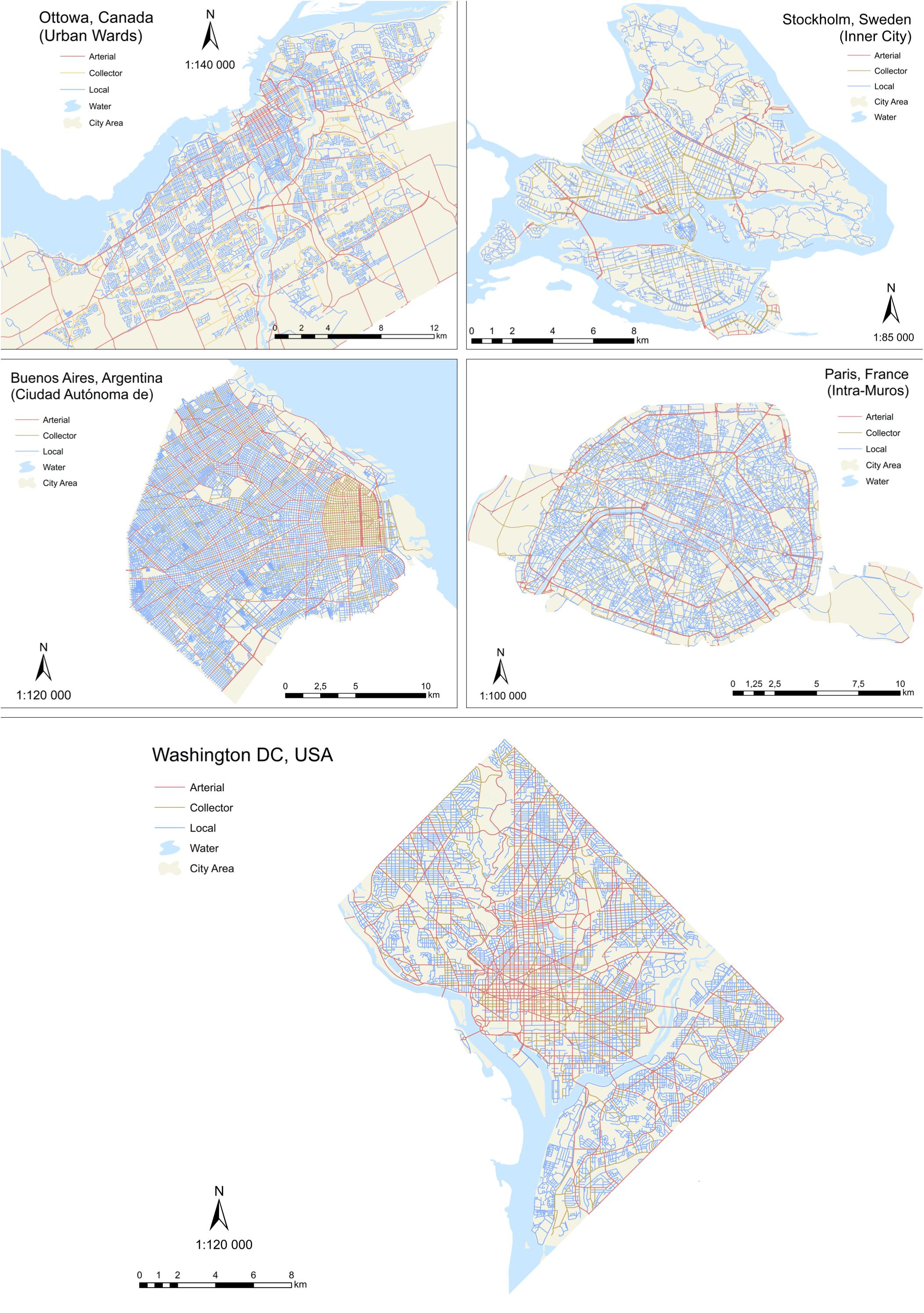
Figure 1. Maps of the central zones and street hierarchies for the five cities in the study.
Urban tree inventory research has emerged over the past four decades and has grown to encompass a variety of methods, including satellite-assisted data collection, airplane-assisted data collection, and both ground-level photography and manual visual inspection methods (Nielsen et al., 2014). In our study, spatial data for trees, streets, jurisdictional areas, and bodies of water (used to identify bridges) in each city were obtained from open data portals and third-party sources including public institutions, municipalities, national governments, and research organizations (see Table 1). The exception to this is the street dataset for Paris, the content of which was sourced from OpenStreetMap (OpenStreetMap, 2019).
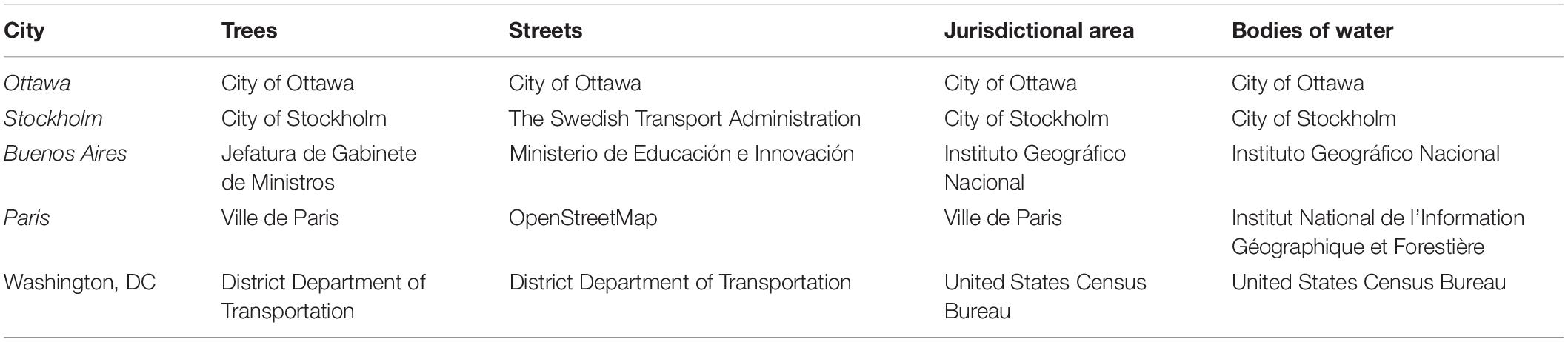
Table 1. Sources of spatial data for the five cities.
The datasets for each of these cities are routinely updated and the most recent version of each inventory is from 2019. There is variability in the methods of data collection by each locality; this constitutes one of the inherent challenges of doing comparative research across cities and countries (Keller and Konijnendijk, 2012; Östberg et al., 2013; Cowett and Bassuk, 2014). For example, the tree inventory in Ottawa is updated through daily operations by multiple city departments when new trees are planted, which occurs through a number of planting programs. Private contractors are, in turn, responsible for accurately reporting the establishment of new trees to the municipality’s planning department (Urban Forest Innovations Inc. et al., 2017). The city’s inventory includes trees located on city-controlled public land except for new subdivision development1. The tree inventory in Stockholm was retrieved from a city-wide mapping database that is continuously updated using satellite-supported control points and photogrammetry (City of Stockholm, 2019); it contains at least 90% of the street trees in the inner city beyond those that are newly planted or located in newly built areas2. In Buenos Aires, the tree inventory data is the product of annual on-site surveys of the city’s trees3; officials in this city did not respond to inquiries about completeness. Launched in 2001, the tree database for the City of Paris is updated weekly when trees are serviced and contains all the street trees planted in the city’s public domain4 (City of Paris, 2019). Tree inventory data in Washington, DC is continuously updated (District of Columbia Department of Transportation [DDOT], 2020); it contains all the trees under its management purview and is at least 95% complete according to city officials5.
Data Collection and Analysis
Data were processed in ArcMap to categorize each city’s street network and to facilitate quantitative analysis of street tree density and distribution in Excel and MATLAB. There was variation in the definition of the urban core and the street classification system for each city. For example, the urban core of Ottawa was derived from the twelve urban wards (constituting a land area of 323 km2), while the urban core of Stockholm was derived from four inner city districts (constituting a land area of 36 km2). Ottawa and Stockholm are the largest and smallest urban cores in the study with Buenos Aires (204 km2), Paris (103 km2) and Washington, DC (158 km2) having intermediate spatial extents. With respect to street classification, the number of functional classes ranged from 4 in Buenos Aires to 32 in Paris.
To establish a consistent hierarchy of streets, the street network in each city was normalized to three classes commonly used in traffic engineering: local, collector, and arterial (USDOT, 2013; European Commission, 2020). In all cities except Paris, these functional classes were provided by local authorities. In Paris, OpenStreetMap data was used because the local authority does not use functional classes. The determination of the classification of street segments in each city was based on the cities’ respective GIS attribute tables that most closely corresponded to a hierarchical classification of local, collector, and arterial streets. For example, in the local inventory created in Ottawa, streets were separated into 14 subclasses; in Stockholm, streets were graded numerically into 10 classes; in Buenos Aires, five hierarchical network categories were used; in Washington, DC, seven functional labels were used; and in the open-source data used in Paris, 32 roadway type labels were used. After reclassifying these heterogenous labels into local, collector, and arterial streets, the data in each city was ground truthed using Google Earth and Google Maps to confirm that the street classes were consistent across the cities. The resulting street classes are included in the maps of each city (Figure 1).
Official street tree definitions were identified in three of the five cities from a review of publicly available online information and through inquiries to municipal representatives. The definitions from the three cities are fairly consistent and designate street trees as those trees located in the public rights-of-way on city streets (see Table 2). A similar interpretation is assumed for the two cities that do not have an official definition.
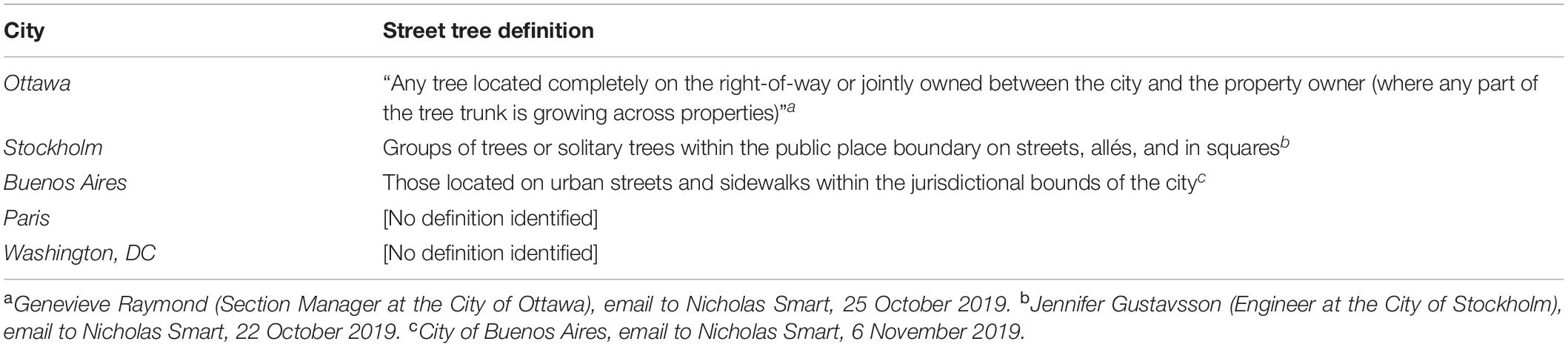
Table 2. Local authority definitions of street trees in each city.
To reduce the heterogeneity of data derived from our cities, two strategies were employed. The first of these concerns street datasets, which were cleaned by removing irrelevant street segments representing highways, tunnels, and bridges (which rarely include street trees). Bridges were assumed to be portions of street segments that spanned bodies of water, and were removed by means of geographic overlay, allowing for a more granular quantification of street network length. The second method to reduce heterogeneity across the data concerns street tree data obtained from local authorities, which was cleaned by first removing datapoints categorized as non-street trees, subsequently removing datapoints flagged as dead, non-existent, or duplicate, and finally by applying a buffer to ensure that all trees were located within 30 m of roadway centerlines (see Figure 2). The value of 30 m was chosen as a compromise between the need to remove trees that were not in close proximity to streets and to include trees that lined wide streets. It is important to note that the existing street tree datasets in each city were useful to streamline the analysis, but such data is not readily available in all cities. Where street tree datasets are not available, it would be necessary to develop the dataset by conducting satellite data analysis or a manual visual inventory.
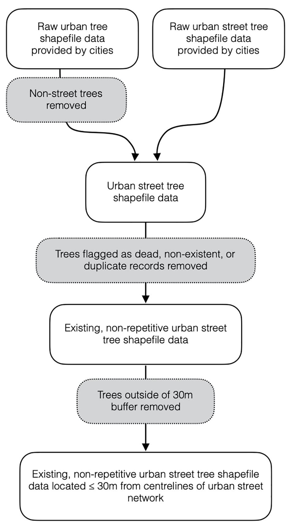
Figure 2. Street tree data filtration process.
In each city, geospatial analysis was used to calculate the street tree density for each street segment as well as to identify the coordinate points of each segment. The coordinate points corresponding to typical segments were then used in Google Street View to obtain visual representations with minimal seasonal variation for each hierarchical class across all cities. The visual representations were used to illustrate the mean street tree density for each class in each city as experienced by the “peripatetic subject” (Hillier et al., 1993).
Data were graphed for comparative analysis using Excel and MATLAB, and subsequently tabulated with imagery from Google Street View. Street tree point data were spatially joined to roadway segment polyline data in ArcMap to produce a segment-based density metric. The length of a given segment was used to produce a weighted mean density for each street class within a city as well as a city-wide weighted mean across all street classes. To assess the distribution of street trees across a given city, these weighted mean density values were plotted in an Excel bar chart and tabulated with its typical street image to provide an in situ visual depiction to allow for comparison of tree density by street class.
Results
Comparison Across Climate
The street tree density for the three street classes in each city as well as a weighted mean for the entire city are summarized in Figure 3. Buenos Aires had the highest street tree density, while Stockholm had the lowest street tree density. The difference in city-wide weighted mean street tree density between these two cities is almost 10-fold. Results in Figure 3 show that cities in the warmer climate zones (Cfa/Cfb) in this study generally exhibit greater street tree density city-wide as well as across most street classes. Buenos Aires, Paris, and Washington, DC averaged 9.9, 4.9, and 7.3 trees/100 m, respectively. In the cooler climate zone (Dfb), Ottawa and Stockholm averaged 3.5 and 1.0 trees/100 m, respectively.
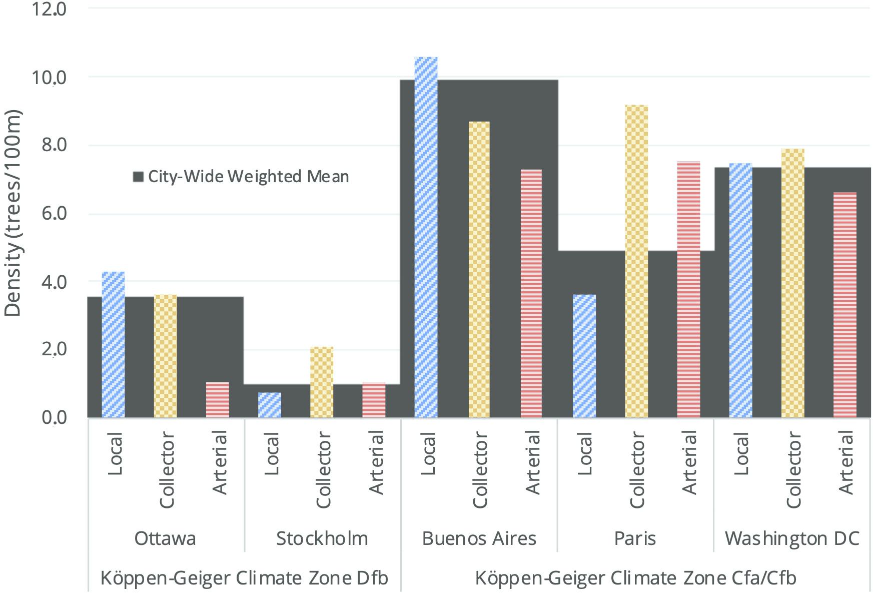
Figure 3. Weighted mean street tree density by street class, city, and climate zone.
In the cooler climate zone, the city-wide density of Ottawa (3.5 trees/100 m) was over three times greater than that of Stockholm (1.0 trees/100 m). Much of the difference in the city-wide density of the cities can be attributed to the local street class in the two cities (Ottawa averaged 4.3 trees/100 m and Stockholm averaged 0.8 trees/100 m), in contrast to the similar densities of the arterial street class in each city (1.1 and 1.0 trees/100 m, respectively). In the warmer climate zone, Buenos Aires, Paris, and Washington, DC exhibited marked differences in street tree density on local streets (10.6, 3.6, and 7.5 trees/100 m, respectively) but similar densities on collector streets (8.7, 9.2, and 7.9 trees/100 m, respectively) and arterial streets (7.3, 7.5, and 6.6 trees/100 m, respectively).
Statistical Distribution of Street Tree Density by Segment
Figure 4 includes box and whisker plots to compare and contrast the statistical distribution of street tree density for each street segment. Across the five cities, the street segments in Buenos Aires had the highest density, with 50% of its segments having 4.9–13.7 trees/100 m. This was followed closely by Washington, DC with 50% of street segments having 4.1–10.6 trees/100 m. Ottawa and Paris had similar distributions and the lower 25% of the segments studied in each of these cities had no street trees. The middle 50% of street segments in Ottawa had 0.0–6.5 trees/100 m as compared to Paris with 0.0–5.9 trees/100 m. Stockholm was an anomaly among the five cities with the majority of street segments (76.4%) having no trees.
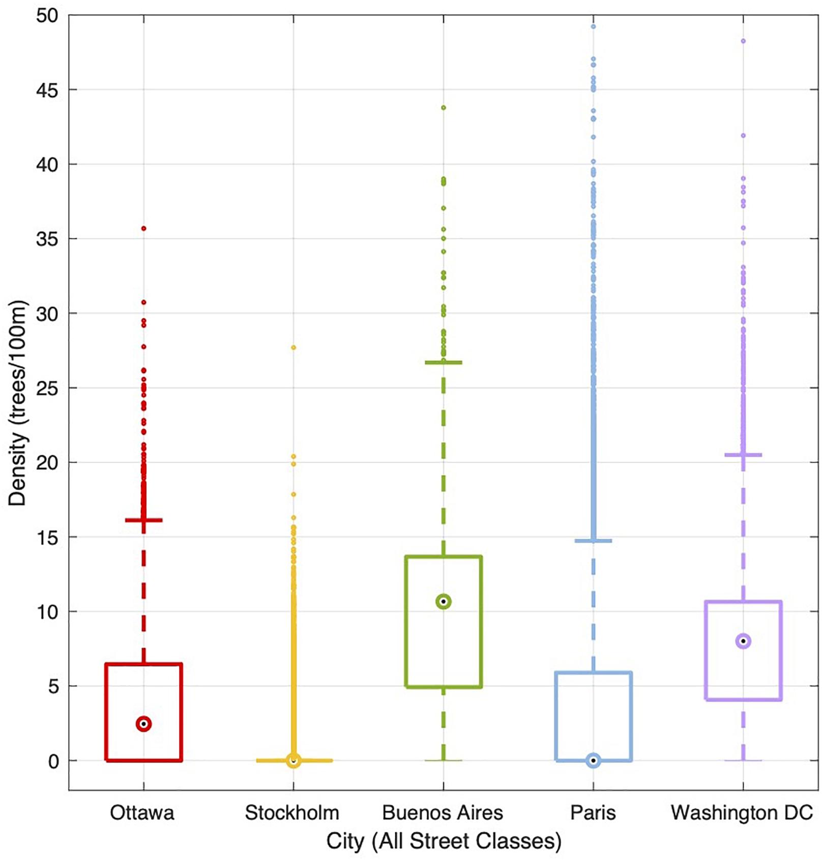
Figure 4. Statistical distribution of street tree density by street segment.
Comparison Across Street Class
Google Street View images representing the street tree density for each street class are presented in Table 3. This is the same data as included in Figure 3 with the addition of images to provide a visualization of street tree density values for each street class. They serve as a visual representation of what a person might experience while standing in the middle of the street with their gaze aligned with its axis. The images show distinct differences in visual experience depending on the street tree density and street class.
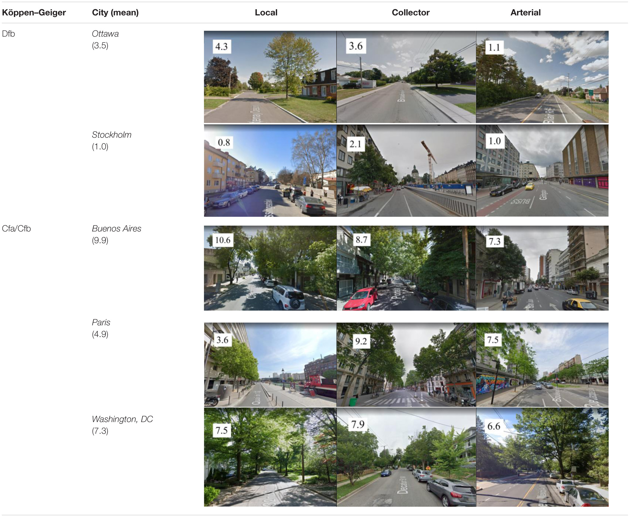
Table 3. Typical street view depiction for street tree density (trees per 100m) by street class.
The data reveal distinct differences in street tree density across the street classes, though no conclusive patterns can be defined for a given street class. Collector streets exhibited the highest street tree density in three out of five cities. The arterial street class in Paris exhibited the highest street tree density (7.5 trees/100 m) of all cities, and this is illustrated in the typical westward-looking view of Boulevard Lefebvre. Likewise, the collector class streets in Paris exhibited a higher street tree density (9.2 trees/100 m) than the collector street class of the other cities, as shown in the southwest-looking image of Boulevard Henri IV. In contrast, the local street class of Buenos Aires had a higher street tree density (10.6 trees/100 m) than the local street class of the other cities, as shown in the northeast-looking image of Camarones.
Arterial streets in Ottawa had a lower street tree density than the collector and local streets. The local streets comprise 66% of the total street network and the average of 4.3 trees/100 m is almost four times greater than the arterial streets (1.1 trees/100 m). Stockholm’s collector streets (2.1 trees/100 m) had a higher street tree density than local and arterial streets (0.8 and 1.0 trees/100 m, respectively). Reflecting the city’s large number of treeless street segments, the median value of all street classes in Stockholm is 0 trees/100 m. Buenos Aires’ local streets had a slightly higher street tree density (10.6 trees/100 m) than its collector (8.7) and arterial (7.3) streets. The street network of Buenos Aires is largely composed of local streets (74% by network length) and has a street tree density of 10.6 trees/100 m. Collector streets in Paris had a higher street tree density (9.2 trees/100 m) than local and arterial streets, although local streets account for a larger proportion (73%) of the city’s total street network, and have a much lower weighted mean (3.6 trees/100 m). Outliers in the Paris dataset are abundant and thus, there is a wide range of street tree densities on individual street segments (Figure 4). In Washington, DC, local, collector, and arterial streets exhibited comparable linear street tree densities (7.5, 7.9, and 6.6 trees/100 m, respectively), exhibiting the most consistent street tree distribution of all of the cities studied. As with the other cities, the local streets accounted for the largest proportion (62%) of the city’s street network by length and have the highest weighted mean (7.5 trees/100 m).
Discussion
This study illustrates clear differences in urban street tree density (the number of trees per 100 m of street) between the two climate zones, as well as within the same climate zone. The street tree density in the three warmer climate zone cities (Cfa/Cfb) ranged from 4.9 to 9.9 trees/100 m, while in the two cooler climate zone cities (Dfb) it ranged from 1.0 to 3.5 trees/100 m—a notable difference between and within climate zones. Within the cooler climate zone, the streets of Ottawa were on average 3.5 times as tree-dense as the streets of Stockholm, and in the warmer climate zone, the streets of Buenos Aires were on average two times as tree-dense as Paris.
The findings also show clear differences in the distribution (the number of trees per 100 m across hierarchical street classes) of street trees in cities located in the same climate zone. In Ottawa, street tree density decreased moving up the hierarchy of street classes (from 4.3 trees/100 m on local streets to 1.1 trees/100 m on arterial streets), while Stockholm exhibited a higher street tree density in its collector streets (2.1 trees/100 m) compared to its local (0.8 trees/100 m) and arterial (1.0 trees/100 m) streets. Street tree density in Buenos Aires decreased for larger streets (from 10.6 trees/100 m along local streets to 7.3 trees/100 m along arterial streets) in the same way as Ottawa, while the collector street class of Paris had a higher tree density (9.2 trees/100 m) than its local (3.6 trees/100 m) and arterial (7.5 trees/100 m) streets, similar to Stockholm. Washington, DC, on the other hand, exhibited comparable street tree densities across its street hierarchy (7.5, 7.9, and 6.6 trees/100 m).
While this study comprises a small sample size and caution should be exercised in generalizing findings beyond the cases covered, the differences in street tree density and distribution in these five cities is noteworthy. This points to the strong influence of place-specific legacies. Legacy effects can include a broad range of environmental and cultural drivers (Roman et al., 2018), and to understand the scope of these longitudinal forces requires in-depth historical analysis (see for example Campanella, 2003; Lawrence, 2006; Roman et al., 2018; Laurian, 2019). Such an assessment is beyond the scope of this paper. Having established that substantial differences in street tree density and distribution do exist in the cities investigated in this study, we now offer a preliminary discussion of potential legacies that may explain these findings, with the understanding that this initial inquiry is exploratory and by no means comprehensive.
Legacy Effects
As noted in Figure 3 and Table 3, Ottawa and Stockholm have the lowest street tree densities of the five study cities. At first glance, it may seem that environmental factors explain why these cities in the Dfb zone (characterized by a snowy climate, fully humid conditions, and warm summer temperatures) have fewer street trees than the three cities located in the Cfa/Cfb zone (characterized by a warm temperate climate, fully humid conditions, and hot/warm summers). But this interpretation may not be so straight-forward, as Ottawa and Stockholm both have cultural legacies that played a role in the relative dearth of street trees. In Ottawa, for example, street trees were viewed as a “veritable nuisance” in the early to mid-twentieth century, with over 4,000 being cut down between 1921 and 1945 (Dean, 2005, p. 46). This decline is attributed to several intersecting forces: the maturation of large street trees planted in the late nineteenth century, the concomitant rise of professional arboriculture, and increased competition for space on city streets with sidewalks, paving, and utility infrastructure. The lack of trees along most of Stockholm’s streets is also noteworthy, and here too, it may be tempting to associate this with the city’s climate, in which shaded streets are not advantageous in the cold and dark winter months (Mcbride, 2017). But as described by Lawrence (2006), Scandinavian cities relied upon architecture and open squares rather than trees to enhance the public realm in the eighteenth century during a time when their European counterparts were planting grand avenues and boulevards. The lack of street trees in Stockholm may also be attributed to a longstanding tradition of centralized urban planning (Andersson and Bedoire, 1988). This contrasts with the decentralized approach to street tree planting that has been commonplace in North America. For example, Dean (2005) notes that most street trees in Ottawa were primarily planted by residents in the nineteenth century. And in the United States, street tree planting has historically been undertaken by a diverse network of actors including civic improvement associations, entrepreneurial individuals, non-profit organizations, private property owners, volunteers, and public sector employees (Summit and Sommer, 1998; Campanella, 2003; Lawrence, 2006; Campbell, 2014; Konijnendijk van den Bosch, 2014). In other words, it is possible that more decentralized governance regimes yield greater density and distribution of urban street trees.
Underlying urban form may also be a factor. In Buenos Aires, street trees are abundant and hierarchically distributed, with local streets displaying the highest tree density. Laid out in 1580 on an orthogonal street grid typical of the “new world” in North and South America (Contreras, 2014), Buenos Aires in the nineteenth century was inspired by Parisian planning—including tree-lined boulevards—to become the “Paris of America” (Gutiérrez, 2002). It was not until the earlier part of the nineteenth century, however, after the immigration of technical experts from Europe, that planning of the city’s green infrastructure was realized (Gutiérrez, 2002; Benito et al., 2018). As noted in Figure 1, the historic core is dominated by collector and arterial streets, which generally have fewer trees than their local counterparts. Importantly, when many street trees were planted in the city in the nineteenth century, the streets of the historic core were deemed too narrow to accommodate street trees, which is why the modern business district lacks trees today (Márquez and Fiorentino, 2007).
In Paris, the study findings show that collector and arterial streets are between two and three times as tree-dense as local streets (see Figure 3 and Table 3). This may be due to changes in urban form and street design driven by shifting priorities and technological changes spanning two millennia, as Paris has roots traceable to 52 B.C.E. (Bournon, 1888). Here, the first urban trees were planted in the fourteenth century in public spaces such as churchyards and marketplaces because the streets were intended for pedestrians and were too narrow to accommodate trees. In the seventeenth century, however, boulevards and avenues were developed on the edge of town to provide open spaces for the upper class to socialize and to facilitate the movement of troops. In the nineteenth century, efforts to improve vistas and public health led to the replacement of large swaths of the city with linear, tree-lined boulevards. These tree-lined streets continue to be an important historical legacy of the city today (Laurian, 2019).
In Washington, DC, by contrast, street tree distribution is fairly even across all street types and the city has on average 2.4 more trees per 100 m street segment than Paris (see Figure 3 and Table 3). This is noteworthy because the city’s physical plan was developed by the French architect Pierre L’Enfant (Bednar, 2006), and the French capital city is often portrayed as a European model for the U.S. counterpart (Bednar, 2006; Dümpelmann, 2019). Yet, Washington, DC exhibits a density and distribution of street trees that is markedly different from that of Paris, where trees are unevenly distributed across street types. These distinctions are a likely outcome of the two cities’ dramatically different histories and their influence on urban form. Moreover, the distinctions may also be influenced by cultural norms related to national identity and aesthetic preferences, including a nineteenth century aspiration in the United States to create the “pastoral city.” According to Campanella (2003, p. 128), this uniquely American urban aesthetic was rooted in antipathy to urbanism and veneration of rural life. This perspective fueled an urban tree planting movement that began in New England with the American elm (Ulmus americana) and was exported to nearly every region of the young republic. Echoing this sentiment, Rutkow (2012, p. 8) describes “trees as one of the great drivers of national development … that helped to forge American identity.” These factors may have informed L’Enfant’s 1791 plan for Washington, DC, which reserved space in the public right-of-way for trees; an 1870 Parking Act that characterized public right-of-ways as linear parks (Government of the District of Columbia, 2011); and 60,000 street tree plantings in the late nineteenth century (Bednar, 2006). This massive urban tree planting initiative—described as the first of its kind in the United States—pushed the city to the brink of bankruptcy, but resulted in over 450 km of streets lined on both sides with trees (Dümpelmann, 2019; District of Columbia Department of Transportation [DDOT], 2020). Today, the nation’s capital is affectionately referred to as the City of Trees (Choukas-Bradley and Alexander, 2008).
Limitations and Future Research
This study is limited to five cites, and for this reason caution should be exercised in generalizing findings beyond the cases covered. An additional limitation of this study is the variation in local data collection methods. This is a fundamental challenge of doing international comparative research, and to reduce the degree to which this variability influenced the findings, protocols were applied as described in the section on “Materials and Methods.”
By showing clear differences in the density and distribution of street trees in cities within and between climate zones, this study illustrates the importance of local legacy effects. As noted by Roman et al. (2018), environmental context sets certain bounds on the trajectory of urban forests, but city trees are embedded in an inherited cultural landscape that is heavily influenced by local sociopolitical history. Yet, these legacies are often lacking when seeking to understand the structure and composition of urban forests today. Moreover, cultural factors including but not limited to urban form, aesthetic norms, and governance regimes—all of which can shift across time—may play a pivotal role in the distribution and density of street trees. These factors are, in turn, substantially influenced by national history and identity (Campanella, 2003; Lawrence, 2006), and likely extend to urban flora writ large. Notwithstanding environmental forces such as pests and extreme weather events, which can both substantially reduce urban tree populations (Campanella, 2003; Duryea et al., 2007; Palmer et al., 2014; Conway and Yip, 2016), this study illustrates that cultural dimensions should be foregrounded in scholarship on street tree density and distribution.
The heterogeneous findings of this study illuminate the need for more comparative analysis of urban greening research and practice across national and cultural settings (Keller and Konijnendijk, 2012), where vernacular norms and aesthetic preferences may differ (Hussain, 2017). This has implications for urban greening practice as well as the stewardship and sustainability of urban flora. As noted by Nassauer (1997), landscapes that people admire may be more likely to survive than those that do not attract care or admiration. This, in turn, argues for greater attention to in situ research methods based on how people actually experience streets in different places. For example, street-level views account for formal and experiential dimensions of trees that aerial perspectives do not.
Because this study relied upon a small sample of cities and only addressed two climate zones, it would be useful to expand this research to a wider range of climates and cultural contexts. This study also highlights opportunities to advance new geospatial research methods. For example, the original approach to the study involved the use of Google Earth satellite imagery to manually count trees on a 100 m segment of city street closest to the centroids of 100 cells of a grid overlaying the municipal boundary of each study city. But through the course of research, up-to-date geospatial street tree and street network datasets were identified and acquired for each city. This type of data may not be available in many cities, in which case the aforementioned method may be appropriate.
Conclusion
This comparative assessment of street tree density and distribution reveals substantial variation across five capital cities spanning two climate zones, and these differences can be attributed to place-specific legacy effects. The environmental legacy of a city was observed to inform differences in street tree density: Ottawa and Stockholm, located in the cooler climate zone, generally exhibited lower street tree density than Buenos Aires, Paris, and Washington, DC, which are located in warmer climate zones. However, the findings also suggest that street tree density and distribution cannot be explained by environmental factors alone. The tree density on local streets in Buenos Aires and Washington, DC was more than double that of Paris, while tree density on local streets in Ottawa was more than four times that of Stockholm. Moreover, the distribution of trees across a three-tiered street classification showed no consistent pattern. These findings reinforce the importance of place-specific legacies as determinants of citywide street tree density and distribution. Substantial differences within climate zones further suggest that cultural factors including but not limited to urban form, aesthetic norms, and governance regimes may play a pivotal role in the distribution and density of street trees, and these dimensions should be foregrounded in urban greening scholarship.
Data Availability Statement
Publicly available datasets were analyzed in this study. This data can be found here: Ottawa tree inventory: Open Ottawa https://open.ottawa.ca/datasets/tree-inventory; Ottawa street network: Open Ottawa https://open.ottawa.ca/datasets/road-centrelines; Ottawa jurisdictional area: Open Ottawa https://open.ottawa.ca/datasets/wards; Ottawa bodies of water: Open Ottawa https://open.ottawa.ca/datasets/water; Stockholm tree inventory: Open Stockholm https://dataportalen.stockholm.se; Stockholm street network: Open Stockholm (Baskarta) https://dataportalen.stockholm.se; Stockholm jurisdictional area & bodies of water: Open Stockholm (T tortskartan Stockholms l n) https://dataportalen.stockholm.se; Buenos Aires Tree Inventory: Buenos Aires Data https://data.buenosaires.gob.ar/da taset/arbolado-publico-lineal; Buenos Aires street network: Buenos Aires Data https://data.buenosaires.gob.ar/dataset/calles; Buenos Aires jurisdictional area and bodies of water: Base de Datos Geoespacial Institucional https://www.ign.gob.ar; Paris tree inventory: Open Data Paris (Les arbres) https://opendata.paris.fr; Paris street network: Open Street Map via data.gouv.fr (Carte des D partements) https://www.data.gouv.fr; Paris jurisdictional area: Open Data Paris (Arrondissements) https://opendata.paris.fr; Paris bodies of water: Institut National de l’Information G ographique et Foresti re (BD TOPO® Hydrographie) https://www.data.gouv.fr; Washington, D.C. tree inventory: Open Data DC (Urban Forestry Street Trees) https://opendata.dc.gov; Washington, D.C. street network: Open Data DC (Street Centerlines) https://opendata.dc.gov; Washington, D.C. jurisdictional area: United States Census Bureau (District of Columbia Tiger/Line Shapefile) https://catalog.data.gov; Washington, D.C. bodies of water: United States Census Bureau (District of Columbia Hydrography Shapefile) https://catalog.data.gov.
Ethics Statement
Written informed consent was obtained from the individual(s) for the publication of any potentially identifiable images or data included in this article.
Author Contributions
TSE conceptualized the study. NS developed the methodology, acquired and curated the data, and led data analysis. AK and TSE supervised the analysis and writing process. NS created the original draft. All authors edited and revised subsequent drafts of the manuscript, approved the final version, and agree to be held accountable for the work.
Funding
This research was supported by the KTH Royal Institute of Technology.
Conflict of Interest
The authors declare that the research was conducted in the absence of any commercial or financial relationships that could be construed as a potential conflict of interest.
Acknowledgments
We would like to thank the School of Architecture and the Built Environment at the KTH Royal Institute of Technology for funding this study and hosting Theodore Eisenman as a visiting scholar in the fall of 2019.
Footnotes
- ^ Genevieve Raymond (Section Manager at the City of Ottawa), email to Nicholas Smart, 24 August 2020.
- ^ Jennifer Gustavsson (Engineer at the City of Stockholm), email to Nicholas Smart, 1 September 2020.
- ^ City of Buenos Aires, email to Nicholas Smart, 18 February 2020.
- ^ Rederic Toussaint (Chef de la Cellule Méthode et Patrimoine), email to Nicholas Smart, 5 October 2020.
- ^ Earl Eutsler (Associate Director at DDOT Urban Forestry Division), email to Nicholas Smart, 31 August 2020.
References
Andersson, H. O., and Bedoire, F. (1988). Stockholm Architecture and Townscape, 4th, edn. Stockholm: Bokförlaget Prisma.
Bednar, M. (2006). L’Enfant’s Legacy: Public Open Spaces in Washington, D.C. Baltimore, MA: John Hopkins University Press.
Benito, G., Palermo, M., and Bertucelli, C. (2018). Arboricultura urbana: antecedentes y evolución. experiencia educativa de formación técnica en fauba. Rev. Facult. Agron. UBA 38:12
Berghauser Pont, M., Stavroulaki, G., Bobkova, E., Gil, J., Marcus, L., Olsson, J., et al. (2019). The spatial distribution and frequency of street, plot and building types across five european cities. Environ. Plann. B Urban Ana. City Sci. 46, 1226–1242. doi: 10.1177/2399808319857450
Birch, E. L., ed. (2009). The Urban and Regional Planning Reader. The Routledge Urban Reader Series. London; New York: Routledge.
Bournon, F. (1888). Petite Histoire de Paris: Histoire - Monuments - Administration Environs de Paris. Paris: Librairie Classique Armand Colin et Cie.
Breger, B. S., Eisenman, T. S., Kremer, M. E., Roman, L. A., Martin, D. G., Rogan, J., et al. (2019). Urban tree survival and stewardship in a state-managed planting initiative: a case study in holyoke, massachusetts. Urban Forestry & Urban Green. 43:126382. doi: 10.1016/j.ufug.2019.126382
Campanella, T. J. (2003). Republic of Shade: New England and the American Elm. New Haven, CT: Yale University Press.
Campbell, L. K. (2014). Constructing New York City’s urban forest: the politics and governance of the MillionTreesNYC campaign. In Urban Forests, Trees, and Greenspace: A Political Ecology Perspective, eds A. L. Sandberg, A. Bardekjian, and S. Butt (Florence, KY: Routledge), 242–260.
Campbell, L. K. (2017). City of Forests, City of Farms: Sustainability Planning for New York City’s Nature. Ithaca, NY: Cornell University Press.
Choukas-Bradley, M., and Alexander, P. (2008). City of Trees: The Complete Field Guide to the Trees of Washington, D.C, 3rd Edn. Charlottesville, VA: University Press of Virginia Press.
City of Paris (2019). L’arbre à Paris. Paris.fr. Avaliable at: https://www.paris.fr/pages/l-arbre-a-paris-199? (accessed November, 2019).
City of Stockholm (2019). Baskarta (1:400–1:2000): Alla Metadata. Available at: https://dataportalen.stockholm.se/dataportalen/?SplashScreen=No (accessed November, 2019).
Contreras, L. (2014). Historia Cronológica de la Ciudad de Buenos Aires 1536-2014. 1st Edn. Buenos Aires: Editorial Dunken.
Conway, T. M., and Yip, V. (2016). Assessing residents’ reactions to urban forest disservices: a case study of a major storm event. Landsc. Urban Plan. 153, 1–10. doi: 10.1016/j.landurbplan.2016.04.016
Cowett, F. D., and Bassuk, N. L. (2014). Statewide assessment of street trees in New York State, USA. Urban For. Urban Green. 13, 213–220. doi: 10.1016/j.ufug.2014.02.001
Dean, J. (2005). ‘Said tree is a veritable nuisance’: Ottawa’s street trees 1869-1939. Urban History Rev. 34, 46–57. doi: 10.7202/1016046ar
Deb, J. C., Halim, M. D., Rahman, H. M. T., and Al-Ahmed, R. (2013). Density, diversity, composition and distribution of street trees in sylhet metropolitan city of bangladesh. Arboricult. J. 35, 36–49. doi: 10.1080/03071375.2013.770656
District of Columbia Department of Transportation [DDOT] (2020). A Brief History of Urban Forestry in DC. Davis, CA: DDOT Urban Forestry Division.
Dümpelmann, S. (2019). Seeing Trees: A History of Street Trees in New York City and Berlin. New Haven, CT: Yale University Press.
Duryea, M. L., Kampf, E., and Littell, R. C. (2007). Hurricanes and the Urban forest: i. effects on southeastern united states coastal plain tree species. Arboricul. Urban For. 33, 83–97.
Eisenman, T. S. (2016). Greening cities in an urbanizing age: the human health bases in the nineteenth and early twenti-first centuries. Change Over Time 6, 216–246. doi: 10.1353/cot.2016.0014
Ernstson, H., and Sörlin, S., (eds). (2019). Grounding Urban Natures: Histories and Futures of Urban Ecologies. Urban and Industrial Environments. Cambridge, MA: The MIT Press.
Feng, Y., and Tan, P. Y. (2017). Imperatives for greening cities: a historical perspective. in greening cities: forms and functions, Advances in 21st Century Human Settlements, eds P. Y. Tan and C. Y. Jim (Singapore: Springer Singapore), 41–70. doi: 10.1007/978-981-10-4113-6_3
Fraser, E. D. G., and Kenney, W. A. (2000). Cultural background and landscape history as factors affecting perceptions of the urban forest. J. Arboricult. 26, 106–113.
Gordon, D. L. A., (ed.). (2006). Planning Twentieth Century Capital Cities. Planning, History and Environment Series. London: Routledge.
Groffman, P. M., Cavender-Bares, J., Bettez, N. D., Grove, J. M., Hall, S. J., Heffernan, J. B., et al. (2014). Ecological homogenization of Urban USA. Front. Ecol. Environ. 12, 74–81. doi: 10.1890/120374
Gutiérrez, R. (2002). Buenos Aires, A Great European City. In Planning Latin America’s Capital Cities, 1850-1950. 2. New York, NY: Routledge.
Gwedla, N., and Shackleton, C. M. (2017). Population size and development history determine street tree distribution and composition within and between Eastern Cape Towns, South Africa. Urban For. Urban Green. 25, 11–18. doi: 10.1016/j.ufug.2017.04.014
Hauer, R., and Petersen, W. (2016). Municipal Tree Care and Management in the United States: A 2014 Urban & Community Forestry Census of Tree Activities. Special Publication 16-1, Stevens Point, WI: University of Wisconsin – Stevens Point.
Hillier, B., Penn A., Hanson, J., Grajewski, T., and Xu, J. (1993). Natural movement: or, configuration and attraction in urban pedestrian movement. Environ. Plann. B Plan. Des. 20, 29–66. doi: 10.1068/b200029
Horte, O. S., and Eisenman, T. S. (2020). Urban greenways: a systematic review and typology. LAND 9:40. doi: 10.3390/land9020040
Huang, J., Lu, X. X., and Sellers, J. M. (2007). A global comparative analysis of urban form: applying spatial metrics and remote sensing. Landsc. Urban Plan. 82, 184–197. doi: 10.1016/j.landurbplan.2007.02.010
Hussain, M. (2017). The Pursuit of Comparative Aesthetics: An Interface Between the East and West. New York, NY: Routledge.
Keller, J. K. K., and Konijnendijk, C. C. (2012). Short communication: a comparative analysis of municipal urban tree inventories of selected Major Cities in North America and Europe. Arboricult. Urban For. 38, 24–30.
Konijnendijk, C. C. (2008). The Forest and the City: The Cultural Landscape of Urban Woodland. New York, NY: Springer.
Konijnendijk van den Bosch, C. C. (2014). From government to governance: contribution to the political ecology of urban forestry. In Urban Forests, Trees, and Greenspace?: A Political Ecology Perspective, eds A. L. Sandberg, A. Bardekjian, and S. Butt (Florence, KY: Routledge), 35–47.
Kostof, S. (1991). The City Shaped: Urban Patterns and Meanings Through History. London: Thames and Hudson.
Kottek, M., Grieser, J., Beck, C., Rudolf, B., and Rubel, F. (2006). World map of the köppen-geiger climate classification updated. Meteorol. Z. 15, 259–263. doi: 10.1127/0941-2948/2006/0130
Kuruneri-Chitepo, C., and Shackleton, C. M. (2011). The distribution, abundance and composition of street trees in selected towns of the Eastern Cape, South Africa. Urban For. Urban Green. 10, 247–254. doi: 10.1016/j.ufug.2011.06.001
Laurian, L. (2019). Planning for street trees and human–nature relations: lessons from 600 years of street tree planting in Paris. J. Plan. History 18:153851321882052. doi: 10.1177/1538513218820525
Lawrence, H. W. (2006). City Trees: A Historical Geography from the Renaissance Through the Nineteenth Century. Charlottesville, VA: University of Virginia Press.
Márquez, F., and Fiorentino, J. (2007). Origen del Arbolado Porteño. Gobierno de Buenos Aires. Colección Azulejo. Avaliable at: https://issuu.com/fabiomarquez/docs/origen_del_arbolado_porte_o_-_colecci_n_azulejo_n_ (accessed January, 2020).
Massengale, J., and Dover, V. (2014). Street Design: The Secret to Great Cities and Towns. Hoboken, NJ: John Wiley & Sons.
Mcbride, J. R. (2017). The World’s Urban Forests: History, Composition, Design, Function and Management. Vol. 8, New York, NY: Springer.
Miller, R. W., Hauer, R. J., and Werner, L. P. (2015). Urban Forestry Planning and Managing Urban Greenspaces, 3rd Edn. Long Grove, IL: Waveland Press.
Nagendra, H., and Gopal, D. (2010). Street trees in bangalore: density, diversity, composition and distribution. Urban For. Urban Green. 9, 129–137. doi: 10.1016/j.ufug.2009.12.005
Nassauer, J. I. (1997). Cultural sustainability: aligning aesthetics and ecology. In Placing Nature: Culture & Landscape Ecology, ed J. I. Nassauer. (Washington, DC: Island Press).
Nielsen, A. B., Östberg, J., and Delshammar, T. (2014). Review of urban tree inventory methods used to collect data at single-tree level. Arboricult. Urban For. 40, 96–111.
OpenStreetMap (2019). Carte des départements. Available at: https://www.data.gouv.fr/fr/datasets/carte-des-departements-2-1/ (accessed November, 2019).
Östberg, J., Delshammar, T., Wiström, B., and Nielsen, A. B. (2013). Grading of parameters for urban tree inventories by city officials, arborists, and academics using the delphi method. Environ. Manag. 51, 694–708. doi: 10.1007/s00267-012-9973-8
Palmer, S., Martin, D., DeLauer, V., and Rogan, J. (2014). Vulnerability and adaptive capacity in response to the asian longhorned beetle infestation in Worcester, Massachusetts. Hum. Ecol. 42, 965–77. doi: 10.1007/s10745-014-9695-z
Pham, T. T. H., Apparicio, P., Landry, S., and Lewnard, J. (2013). Disentangling the effects of urban form and socio-demographic context on street tree cover: a multi-level analysis from montréal. Landsc. Urban Plan. 157, 422–433. doi: 10.1016/j.landurbplan.2016.09.001
Pincetl, S. (2015). Cities as novel biomes: recognizing urban ecosystem services as anthropogenic. Front. Ecol. Evol. 3:140. doi: 10.3389/fevo.2015.00140
Pincetl, S., Gillespie, T., Pataki, D. E., Saatchi, S., and Saphores, J. D. (2013). Urban tree planting programs, function or fashion? Los angeles and urban tree planting campaigns. GeoJournal 78, 475–493. doi: 10.1007/s10708-012-9446-x
Roman, L. A., Pearsall, H., Eisenman, T. S., Conway, T. M., Fahey, R. T., Landry, S., et al. (2018). Human and biophysical legacies shape contemporary urban forests: a literature synthesis. Urban For. Urban Green. 31, 157–168. doi: 10.1016/j.ufug.2018.03.004
Roman, L. A., Walker, L. A., Martineau, C. M., Muffly, D. J., MacQueen, S. A., Harris, W. et al. (2015). Stewardship matters: case studies in establishment successof urban trees. Urban For. Urban Green. 14, 1174–1182. doi: 10.1016/j.ufug.2015.11.001
Rutkow, E. (2012). American Canopy: Trees, Forests, and the Making of a Nation. New York, NY: Scribner.
Shackleton, C. M. (2012). Is there no urban forestry in the developing world? Sci. Res. Essays 7, 3329–3335. doi: 10.5897/sre11.1117
Shams, Z. I., Shahid, M., Nadeem, Z., Naz, S., Raheel, D., Aftab, D., et al. (2020). Town socio-economic status and road width determine street tree density and diversity in karachi, pakistan. Urban For. Urban Green. 47:126473. doi: 10.1016/j.ufug.2019.126473
Sjöman, H., Östberg, J., and Bühler, O. (2012). Diversity and distribution of the urban tree population in ten major nordic cities. Urban For. Urban Green. 11, 31–39. doi: 10.1016/j.ufug.2011.09.004
Strunk, J. L., Mills, J. R., Ries, P., Temesgen, H., and Jeroue, L. (2016). An urban forest-inventory-and-analysis investigation in Oregon and Washington. Urban For. Urban Green. 18, 100–109. doi: 10.1016/j.ufug.2016.04.006
Summit, J., and Sommer, R. (1998). Urban Tree-Planting Programs — A model for encouraging environmentally protective behavior. Atmos. Environ. 32, 1–5. doi: 10.1016/S1352-2310(97)00175-1
Tan, P. Y., and Jim, C. Y., (eds). (2017). Greening Cities: Forms and Functions. Advances in 21st Century Human Settlements. Singapore: Springer.
Tanhuanpää, T., Vastaranta, M., Kankare, V., Holopainen, M., Hyyppä, J., Hyyppä, H., et al. (2014). Mapping of Urban Roadside Trees – A case study in the tree register update process in Helsinki City. Urban For. Urban Green. 13, 562–570. doi: 10.1016/j.ufug.2014.03.005
Tigges, J., Churkina, G., and Lakes, T. (2017). Modeling above-ground carbon storage: a remote sensing approach to derive individual tree species information in urban settings. Urban Ecosyst. 20, 97–111. doi: 10.1007/s11252-016-0585-6
Urban Forest Innovations Inc., Beacon Environmental Ltd., and Kenney, W. A. (2017). Putting Down Roots for the Future: City of Ottawa Urban Forest Management Plan 2018–2037. Oakville, ON: Urban Forest Innovations Inc
Keywords: street trees, legacy effects, urban greening, comparative analysis, globalization, urban history
Citation: Smart N, Eisenman TS and Karvonen A (2020) Street Tree Density and Distribution: An International Analysis of Five Capital Cities. Front. Ecol. Evol. 8:562646. doi: 10.3389/fevo.2020.562646
Received: 15 May 2020; Accepted: 14 October 2020;
Published: 23 November 2020.
Edited by:
Mary L. Cadenasso, University of California, Davis, United StatesReviewed by:
Shawn Landry, University of South Florida, United StatesRüdiger Grote, Karlsruhe Institute of Technology (KIT), Germany
Copyright © 2020 Smart, Eisenman and Karvonen. This is an open-access article distributed under the terms of the Creative Commons Attribution License (CC BY). The use, distribution or reproduction in other forums is permitted, provided the original author(s) and the copyright owner(s) are credited and that the original publication in this journal is cited, in accordance with accepted academic practice. No use, distribution or reproduction is permitted which does not comply with these terms.
*Correspondence: Nicholas Smart, bnNtYXJ0QGt0aC5zZQ==; Theodore S. Eisenman, dGVpc2VubWFuQHVtYXNzLmVkdQ==; Andrew Karvonen, YXBrYXJAa3RoLnNl