 Aviraj Datta1
 Savitri Maharaj2*
 G. Nagendra Prabhu3
 Deepayan Bhowmik2
 Armando Marino2
 Vahid Akbari2
 Srikanth Rupavatharam1J. Alice R. P. Sujeetha4Girish Gunjotikar Anantrao4Vidhu Kampurath Poduvattil4
 Saurav Kumar5
 Adam Kleczkowski6
- 1International Crops Research Institute for the Semi-Arid Tropics, Hyderabad, India
- 2Faculty of Natural Sciences, University of Stirling, Stirling, United Kingdom
- 3Centre for Research on Aquatic Resources, Sanatana Dharma College, Alleppey, India
- 4National Institute of Plant Health Management, Hyderabad, India
- 5Central Scientific Instruments Organisation, Chandigarh, India
- 6Mathematics and Statistics, University of Strathclyde, Glasgow, United Kingdom
Water hyacinth (Pontederia crassipes, also referred to as Eichhornia crassipes) is one of the most invasive weed species in the world, causing significant adverse economic and ecological impacts, particularly in tropical and sub-tropical regions. Large scale real-time monitoring of areas of chronic infestation is critical to formulate effective control strategies for this fast spreading weed species. Assessment of revenue generation potential of the harvested water hyacinth biomass also requires enhanced understanding to estimate the biomass yield potential for a given water body. Modern remote sensing technologies can greatly enhance our capacity to understand, monitor, and estimate water hyacinth infestation within inland as well as coastal freshwater bodies. Readily available satellite imagery with high spectral, temporal, and spatial resolution, along with conventional and modern machine learning techniques for automated image analysis, can enable discrimination of water hyacinth infestation from other floating or submerged vegetation. Remote sensing can potentially be complemented with an array of other technology-based methods, including aerial surveys, ground-level sensors, and citizen science, to provide comprehensive, timely, and accurate monitoring. This review discusses the latest developments in the use of remote sensing and other technologies to monitor water hyacinth infestation, and proposes a novel, multi-modal approach that combines the strengths of the different methods.
Introduction
Originating from the Amazon Basin, water hyacinth (Pontederia crassipes) has spread to more than 80 countries over the past century (Jafari, 2010). This monocotyledonous macrophyte reproduces asexually using stolons and sexually by seeds (Havel et al., 2015), with a rapid reproductive capacity enabling it to double its biomass in 6–14 days under conducive growth conditions (Keller and Lodge, 2009). Researchers have estimated that over 8 months, 10 water hyacinth plants can reproduce into 655,360 plants, covering approximately half a hectare (Gunnarsson and Petersen, 2007). It is thus not surprising that water hyacinth has been listed among the world's worst weeds (Riches, 2001). A comparative assessment of invasive weed species in China (Bai et al., 2013) introduced two indices using a scale of 1–4: “impact index,” representing social, economic, and ecological impacts; and “spread index,” representing rate of spread. Water hyacinth was assessed as having impact index 4 and spread index 3, highlighting its enormous adverse environmental impact. The weed reduces species diversity by reducing penetration of sunlight (Huang et al., 2008), affecting turbidity and dissolved oxygen (Chukwuka and Uka, 2007), depleting nutrients (Brendonck et al., 2003), and disturbing the food-web (Coetzee et al., 2014; Mironga et al., 2014). The thick floating weed mats harbor pathogenic micro-organisms, pests, and insect larvae, promoting diseases like schistosomiasis, dengue, chikungunya, and malaria (Muyodi, 2000). The mats challenge boat traffic by obstructing waterways and damaging propellers, and hamper fishing activity because casting of nets becomes impossible (European Environment Agency, 2000). Trends in urbanization and increased eutrophication of inland and coastal waterbodies imply that these problems will only grow worse in future (Williams et al., 2005).
Effectively tackling this menace requires accurate and timely monitoring of potential water hyacinth habitats within aquatic ecosystems (Shekede et al., 2008). Monitoring is necessary for estimating the size of an infestation, providing data for use in developing strategies for management and control (Dube et al., 2017). Traditionally, water hyacinth infestation monitoring has relied on field surveys with limited spatial coverage, using methods that are time and labor intensive (Ritchie et al., 2003). This limited the amount of data that can be collected, leading to poor understanding of factors affecting the emergence and spread of water hyacinth in different geographies. During the last decade, increasing availability of open sources of satellite data has created new possibilities for low-cost, large scale monitoring of water bodies (Turner et al., 2013). Satellites can provide spatial snapshots, with a short time interval, of areas known for water hyacinth infestation, particularly valuable for inaccessible and vulnerable ecologies or areas of significant commercial interests. However, challenges remain in developing effective automated methods for accurate detection of the presence of water hyacinth in satellite images and discriminating it from other aquatic vegetation that may be present. Potential solutions include using powerful machine learning algorithms that can handle large datasets, and the complementary use of data collected using other methods such as aerial surveys, in-water sensor devices, and technology-assisted surveillance by local people (citizen science).
We describe some of the ways in which water hyacinth is currently managed and explain how these can be made more effective through improved monitoring. Historically, water hyacinth has been treated as a pest requiring eradication or strict control, but there are also novel initiatives to use it as a resource for economic exploitation; improvements in monitoring have benefits for both approaches. We then review a range of technological methods that can be applied and end by proposing a novel, multi-modal approach.
Benefits of Improved Monitoring for Infestation Control
Management practices for water hyacinth infestation have primarily focused on eradication through physical, biological or chemical means, with modest success (Wilson et al., 2007). Mechanical removal of water hyacinth mats is the most common approach, particularly in navigation channels (Toft et al., 2003). Over the last few decades, the insect Neochetina eichhorniae and a suite of other species have been widely used as biocontrol agents in many parts of the world (Center et al., 2002; Hill and Coetzee, 2017). When combined with other plant stress factors, biocontrol has been found to be effective (Reddy et al., 2019). Use of herbicides in coordination with biocontrol has showed considerable success in maintaining the weed within acceptable levels (Tipping et al., 2017). Improvements in monitoring capability will make it possible to compare the efficacy of various control measures at a larger scale and within different geographic and climatic contexts, providing data that can be used to inform the choice of the most appropriate control method when an infestation is detected. Improved monitoring will also make it possible to detect new patches of infestation at an earlier stage, when they can be more easily and cheaply suppressed.
Benefits of Improved Monitoring for Exploitation of Harvested Water Hyacinth Biomass
Efficient utilization of harvested water hyacinth biomass for the production of fuels (biogas, bioethanol, or biohydrogen) and other value-added products will significantly mitigate the nuisance caused by the weed. Researchers have demonstrated bioethanol production potential from the hemicellulose and cellulose rich biomass (Okewale et al., 2016). Several value-added products, including cellulose, xanthogenate, levulinic acid, shikimic acid, biopolymer, biobutanol, composites, biofertilizers, fish feed, superabsorbent polymer, and xylitol have been demonstrated. With only minimal treatment, the biomass can be used as substrate for mushroom cultivation (Kumar et al., 2014; Prabhu, 2016) or for making handicrafts and other products.
Despite this known potential, none of these ideas has yet seen widespread adoption. To develop a financially viable proposal for a large scale processing unit, it is necessary to have data about the expected biomass quantity and time (to optimize scale of processing and assess viability), seasonal variation of the biomass (to schedule operations and plan storage requirements), and site-specific details such as remoteness of the location and proximity to transport routes and markets. Improved monitoring through remote sensing will be able to precisely measure the acreage of water hyacinth mats as well as their seasonal and temporal quantity variations. This will help with quantifying and forecasting biomass availability for commercial planning. There is potential in realizing this opportunity for improving livelihoods in impoverished communities.
Technology-Based Methods of Monitoring Water Hyacinth
Remote Sensing
Satellite remote sensing data has potential for effective and low-cost short interval monitoring of the temporal and spatial distribution of water hyacinth infestation at a large scale. The availability, frequency and coverage of satellite remote sensing data have increased considerably during the last years, in particular due to the European space agency (ESA)'s Copernicus program with Sentinel-1 and Sentinel-2. Currently, this potential is largely unexploited, due in part to the limited training of aquatic scientists and hydrologists in using remote sensing (Nagendra et al., 2013). Table 1 presents a list of currently available open-access satellite-based sensor systems that can be used for monitoring water hyacinth. Remote sensing datasets may come from optical systems or from synthetic aperture radar (SAR). Optical images are typically well-suited for monitoring water hyacinth, because of their high spatiotemporal resolution, wide spatial coverage and broad spectrum. However, they are severely affected by cloud cover and meteorological conditions, and they are dependent on solar illumination. The data can be supplemented with data from SAR sensors which, in general, are unaffected by day-night, clouds and weather conditions. These two types of instruments may supplement each other in operational systems.
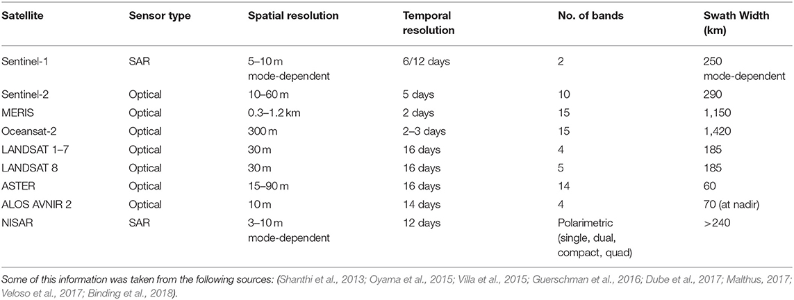
Table 1. Salient features of open access satellite-based sensor systems that can potentially be used for monitoring water hyacinth infestation.
The primary focus of efforts using optical datasets has been to discriminate between hyacinth mats and algal blooms or other aquatic macrophytes. With improved spectral and spatial resolution sensors, the 10 m/pixel ground sampling distance (GSD) of Sentinel-2 MSI (multispectral instrument) has significantly enhanced research capability to detect and estimate water hyacinth infestation and coverage. Submerged macrophytes are clearly distinguished by their lower absolute reflectance in the near infrared (NIR), while other narrow hyperspectral channels are used to discriminate species on the basis of leaf optical properties and other biophysical or biochemical properties (Vidhya et al., 2014, Cheruiyot et al., 2014). Additionally, using remote sensing, critical water quality parameters, such as chlorophyll-a, turbidity and phosphorus concentration can be estimated (primarily through physics-based approaches) with high accuracy (Weghorst, 2008; Yao et al., 2010; Chawira et al., 2013; Kibena et al., 2013; Majozi et al., 2014).
Unlike optical datasets, SAR images have the benefit of being unaffected by cloud cover. Silva et al. (2010) showed the utility of SAR in monitoring of aquatic macrophytes, even during challenging weather conditions. The difference in dielectric constant and roughness between surface water and vegetation allows SAR to discriminate between dry and flooded vegetation (Evans et al., 2010). The lack of penetration of microwaves into water minimizes the error in signal capturing due to presence of submerged vegetation. The intensity of the radar backscatter being directly influenced by surface roughness, volumetric scattering, wavelength information and polarization makes it possible to develop vegetation-specific signatures (Robertson et al., 2015).
Machine Learning Algorithms for Classifying Water Hyacinth in Remote Sensing Data
Machine learning algorithms have potential to significantly improve classification accuracy when identifying water hyacinth within satellite acquired imagery. For examples, the inaccuracy of pixel-based (Zhang and Foody, 1998) can be circumvented using algorithms that can extract expert knowledge derived from secondary data, and statistical tools such as Maximum Likelihood Classifier (Xie et al., 2008).
Atmospheric correction is another area where machine learning can contribute. Traditionally, algorithms for detecting chlorophyll a in MERIS spectrometer data relied on the water-leaving reflectance (Gitelson et al., 2009). However, common atmospheric correction software failed to resolve the shape of the water-leaving reflectance accurately, particularly in the red-NIR MERIS bands for eutrophic waters (Guanter et al., 2010). An Artificial Neural Network approach for atmospheric corrections for Case 2 Regional Coast Color (C2RCC) was developed for MERIS (Doerffer and Schiller, 2008). C2RCC included a 5-component bio-optical model, as well as a coastal aerosol model aimed at expanding MERIS and Sentinel capabilities to coastal and inland waters (Brockmann et al., 2016). The radiative transfer code derived from the simulation of a satellite signal is based on successive orders of scattering approximations and it intends to simulate reflection observed for a typical water surface using a coupled atmosphere-surface system (Martins et al., 2017). POLYMER is used for spectral optimization using polynomials to model separate spectral influence from atmosphere and sunlight (Steinmetz et al., 2011). POLYMER decomposes the total signal after Rayleigh correction into a water reflectance spectrum, a spectrally smooth function for the atmosphere, and everything else which is “non-water.” The iCOR atmospheric correction is a completely image-based processor which uses sun and sensor geometry, aerosol optical depth, ozone, water vapor, and elevation to derive atmospheric parameters from pre-computed MODTRAN (MODerate resolution atmospheric TRANsmission)-5 Look-Up-Tables (De Keukelaere et al., 2018). These approaches greatly enhance the capacity to discriminate between cyanobacterial blooms, surface scum, and floating macrophyte such as water hyacinth.
Other machine learning algorithms that have been applied to remote sensing data include decision tree approaches, used in Song et al. (2012) to improve the accuracy of land cover classification in low-resolution images, random forest (Adelabu and Dube, 2014), and support vector machines (Mountrakis and Ogole, 2011).
Aerial Surveys
Historically the identification of individual species was based on laborious and subjective interpretation of analog or digital aerial high-resolution photography (Husson et al., 2014). The availability of low-cost unmanned aerial vehicles (UAVs) equipped with high-quality digital cameras has resulted in a resurgence of such systems for environmental monitoring (Anker et al., 2014). Airborne optical monitoring can greatly enhance remote monitoring capabilities. The ability of aerial photography to acquire images under the clouds and with much higher resolution makes image interpretation easier compared to satellite data. Common systems in use are CASI (Compact Airborne Spectrographic Imager), MIVIS (Multispectral Infrared and Visible Imaging Spectrometer), HyMAP (airborne hyperspectral imaging sensor), AVIRIS (Airborne Visible/Infrared Imaging Spectrometer), and sensors deployed on UAVs. The high cost of hyperspectral UAV/camera systems is a barrier to their widespread use; however, cheaper multispectral systems have recently become available and are a promising alternative.
Challenges such as changing sun angles and variable wind speeds affect aerial image acquisition, therefore flight scheduling requires skill and site-specific knowledge (Hestir et al., 2008). Airborne sensors provide high spectral resolution and facilitate differentiation of macrophytes strategies (Giardino et al., 2015). Becker et al. (2007) explored various bands of hyperspectral scanner data to derive the optimal system parameters (e.g., resolution, number of bands) to enable classification of common wetland vegetation. Their study reported an optimal spatial resolution of 2 m with strategically located bands in the red-NIR region. Repeated airborne LIDAR acquisitions can be used to produce a high-resolution canopy digital elevation model and canopy height model of the water hyacinth. This can help to track water hyacinth growth and detect infestation at an early stage (Hopkinson et al., 2005).
Ground-Level Sensors
Sensor devices of various kinds can be placed within water and used for detecting indicators of the presence of aquatic plants or the conditions conducive to their growth. Sensors may be used for spot measurements or placed on site long term to detect changing conditions. Maintenance of long-term installations presents various challenges, such as the risk of theft or damage to devices, or reduced effectiveness due to biological colonization. However, if these can be overcome, useful data can be gathered. For example, a spectro-radiometer can be used to detect aquatic plants using their reflectance spectra and discriminate between floating and submerged plants (Penuelas et al., 1993). This ground-level data can be usefully combined with other data to yield better information: for example, Wolf et al. (2013) investigated freshwater lakes in Germany using a submersible spectro-radiometer and suggested that the reflectance spectra of vegetation or sediments on and below the lake bottom were useful to control the atmospheric and water column deviations of remote sensing data from satellites.
Sensors may be combined with actuators and communication capabilities (Internet of Things) for real-time data gathering and early warning systems (Abdullah and Hagem, 2020) placed a Wi-Fi-enabled photon board and an ultrasonic sensor in an irrigational channel to provide an early warning system for detecting Ceratophyllum and Eichhornia. Water quality monitoring was performed using sensors for critical parameters like turbidity, temperature and dissolved oxygen while assessing the impact of herbicides used for control of water hyacinth in the Sacramento-San Joaquin delta (Tobias et al., 2019). Monitoring of phosphate concentration too is important as it is closely linked with water hyacinth infestation (Kobayashi et al., 2008; Datta et al., 2016). An IoT based sensor that monitors water quality in real-time was demonstrated by Manimegalai (2020). Vaseashta et al. (2020) developed a prototype from commercial-off-the-shelf sensors to monitor contaminants in underground and surface water. A detailed review of microfluidic-based sensors for monitoring water quality can be found in Jaywant and Arif (2019).
Citizen Science
The traditional method of monitoring water hyacinth using manual field surveys can be greatly enhanced by the use of smartphones and mobile applications to enable quick and effective data collection. Widespread and growing cellular network penetration in countries across the world has enabled citizen science initiatives such as the Plantix mobile application (Wang et al., 2020), which is used by farmers in India for quick reporting and diagnosis of agricultural pests and diseases found in their fields. Gervazoni et al. (2020) used citizen science to monitor spread of invasive Iris pseudacorus in Argentinian wetlands. There is potential to develop similar applications that can be provided to fishermen, farmers, irrigation workers and other users of waterbodies to report sightings of water hyacinth. Photographs augmented with timing and geolocation data can build a valuable repository of data that can be used for monitoring infestations and can serve as ground-truth data for the development of algorithms for automated detection of water hyacinth from remote sensing data.
Discussion and Proposal for a Multi-Modal Approach to Monitoring Water Hyacinth
We have seen that a wide variety of technological approaches for monitoring water hyacinth infestation are available, though the full potential of most of these is currently underexploited. Remote sensing has considerable advantages over other methods, as it is low in cost and can provide extensive spatial and temporal coverage, enabling ongoing surveillance and reaching inaccessible locations. Optical images can be used for their high resolution and broad coverage and can be supplemented with SAR data to provide datasets that are resilient to cloud coverage and poor weather conditions. Aerial surveys and citizen science can provide detailed, very high-resolution imagery that can be used to complement and ground-truth satellite data. Sensors placed within waterbodies can provide supplementary data and provide early warnings of infestations.
A comprehensive solution to the problem of monitoring water hyacinth must involve a combination of methods. Our team is working to design and test prototypes of a multi-modal system (Figure 1) which can be used to continuously monitor the presence of water hyacinth, using a data driven approach that merges environmental datasets obtained from: (i) SAR and optical imaging by European satellites, essential for understanding spatio-temporal variability of vegetation cover and distribution; (ii) monitoring of target sites using drone-mounted multispectral cameras, essential for collecting very high resolution data to ground truth satellite observations; (iii) continuous real time data from an Internet-of-Things enabled ground sensor network placed permanently in the water, collecting data indicative of water hyacinth presence, such as dissolved oxygen, nutrients, pH levels and temperature, and (iv) citizen science, using a mobile application to gather photographs, timestamps, geolocation data and other metadata about sightings of water hyacinth infestations. New algorithms will be developed, leveraging advances in signal processing, e.g., texture analysis and machine learning techniques, such as deep learning, along with multimodal data fusion strategies. We envisage a system which uses satellite and remote sensing data to detect if weed infestation is present, producing alerts that trigger a drone campaign to acquire more detailed information. The system will include a network of sensors that can sense water quality conditions conducive to water hyacinth growth and detect infestation at an early stage. If successful, this system will provide low-cost, comprehensive, timely, and accurate data for effective management of what many consider the world's worst aquatic weed.
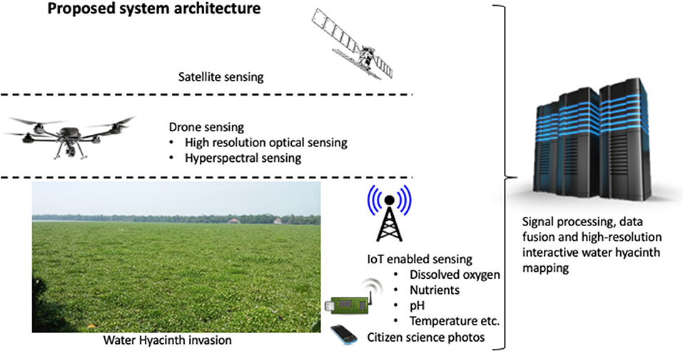
Figure 1. Proposed system architecture for a multi-modal system for monitoring water hyacinth infestation.
Author Contributions
AD conceived the original idea for this paper and carried out most of the literature review. AD, SM, GP, DB, AM, VA, and SR contributed to the writing and preparation of figures. JS, GA, SK, and AK provided feedback on drafts. All authors approved the final submission and agree to be accountable for the content of the paper.
Funding
This work was supported by the UKRI Global Challenges Research Fund through grant (FF\1920\1\37) from the Royal Academy of Engineering.
Conflict of Interest
The authors declare that the research was conducted in the absence of any commercial or financial relationships that could be construed as a potential conflict of interest.
References
Abdullah, N. M., and Hagem, R. M. (2020). Eichhornia and ceratophyllum monitoring system based on IoT for Iraqi's irrigation projects. Al-Rafidain Eng. J. 25, 78–84. doi: 10.33899/rengj.2020.126877.1030
Adelabu, S., and Dube, T. (2014). Employing ground and satellite-based QuickBird data and random forest to discriminate five tree species in a Southern African Woodland. Geocarto Int. 30, 457–471. doi: 10.1080/10106049.2014.885589
Anker, Y., Hershkovitz, Y., Ben Dor, E., and Gasith, A. (2014). Application of aerial digital photography for macrophyte cover and composition in small rural streams. River Res. Appl. 30, 925–937. doi: 10.1002/rra.2700
Bai, F., Chisholm, R., Sang, W., and Dong, M. (2013). Spatial risk assessment of alien invasive plants in China. Environ. Sci. Technol. 47, 7624–7632. doi: 10.1021/es400382c
Becker, B., Lusch, D., and Qi, J. (2007). A classification-based assessment of the optimal spectral and spatial resolutions for Great Lakes coastal wetland imagery. Rem. Sens. Environ. 108, 111–120. doi: 10.1016/j.rse.2006.11.005
Binding, C. E., Greenberg, T. A., McCullough, G., Watson, S. B., and Page, E. (2018). An analysis of satellite-derived chlorophyll and algal bloom indices on Lake Winnipeg. J. Great Lakes Res. 44, 436–446. doi: 10.1016/j.jglr.2018.04.001
Brendonck, L., Maes, J., Rommens, W., Dekeza, N., Nhiwatiwa, T., Barson, M., et al. (2003). The impact of water hyacinth (Eichhornia crassipes) in a eutrophic subtropical impoundment (Lake Chivero, Zimbabwe). II. Species diversity. Arch. Hydrobiol. 158, 389–405. doi: 10.1127/0003-9136/2003/0158-0389
Brockmann, C., Doerffer, R., Peters, M., Stelzer, K., Embacher, S., and Ruescas, A. (2016). “Evolution of the C2RCC neural network for Sentinel 2 and 3 for the retrieval of ocean colour products in normal and extreme optically complex waters,” in Proceedings of the Living Planet Symposium (Prague).
Center, T. D., Hill, M. P., Cordo, H., and Julien, M. H. (2002). Water H yacinth. Biological Control of Invasive Plants in the Eastern United States. Newtown Square, PA: USDA Forest Service Publication FHTET.
Chawira, M., Dube, T., and Gumindoga, W. (2013). Remote sensing based water quality monitoring in Chivero and Manyame lakes of Zimbabwe. Phys. Chem. Earth Parts A/B/C 66, 38–44. doi: 10.1016/j.pce.2013.09.003
Cheruiyot, E. K., Mito, C., Menenti, M., Gorte, B., Koenders, R., and Akdim, N. (2014). Evaluating MERIS-based aquatic vegetation mapping in Lake Victoria. Rem. Sens. 6:77627782. doi: 10.3390/rs6087762
Chukwuka, K. S., and Uka, U. N. (2007). Effects of water hyacinth (Eichhornia crassipes) infestation on zooplankton population in Awa reservoir, Ibadan South-west Nigeria. J. Biol. Sci. 7, 865–869. doi: 10.3923/jbs.2007.865.869
Coetzee, J. A., Jones, R. W., and Hill, M. P. (2014). Water hyacinth, Eichhornia crassipes (Mart.) Solms-Laub. (Pontederiaceae), reduces benthic macroinvertebrate diversity in a protected subtropical lake in South Africa. Biodivers. Conserv. 23, 1319–1330. doi: 10.1007/s10531-014-0667-9
Datta, A., Wani, S. P., Patil, M. D., and Tilak, A. S. (2016). Field scale evaluation of seasonal wastewater treatment efficiencies of free surface constructed wetlands in ICRISAT India. Curr. Sci. 110, 1756–1763. doi: 10.18520/cs/v110/i9/1756-1763
De Keukelaere, L., Sterckx, S., Adriaensen, S., Knaeps, E., Reusen, I., Giardino, C., et al. (2018). Atmospheric correction of Landsat-8/OLI and Sentinel-2/MSI data using iCOR algorithm: validation for coastal and inland waters. Eur. J. Remote Sens. 51, 525–542. doi: 10.1080/22797254.2018.1457937
Doerffer, R., and Schiller, H. (2008). MERIS Lake Water Algorithm for BEAM—MERIS Algorithm Theoretical Basis Document. V1.0, 10 June 2008. Geesthacht: GKSS Research Center.
Dube, T., Mutanga, O., Sibanda, M., Bangamwabo, V., and Shoko, C. (2017). Evaluating the performance of the newly-launched Landsat8 sensor in detecting and mapping the spatial configuration of water hyacinth (Eichhornia crassipes) in inland lakes, Zimbabwe. Phys. Chem. Earth 100, 101–111. doi: 10.1016/j.pce.2017.02.015
European Environment Agency (2000). CORINE Land Cover Technical Guide—Addendum 2000. Technical Report No 40. Available online at: https://www.eea.europa.eu/publications/tech40add (accessed November 12, 2020).
Evans, T., Costa, M., Telmer, K., and Silva, T. (2010). Using ALOS/PALSAR and RADARSAT-2 to map land cover and seasonal inundation in the Brazilian Pantanal. IEEE J. Sel. Top. Appl. 3, 560–575. doi: 10.1109/JSTARS.2010.2089042
Gervazoni, P., Sosa, A., Franceschini, M., Coetzee, J., Faltlhauser, A., Fuentes-Rodríguez, D., et al. (2020). The alien invasive yellow flag (Iris pseudacorus L.) in Argentinian wetlands: assessing geographical distribution through different data sources. Biol. Invasions 22, 3183–3193. doi: 10.1007/s10530-020-02331-4
Giardino, C., Bresciani, M., Valentini, E., Gasperini, L., Bolpagni, R., and Brando, V. E. (2015). Airborne hyperspectral data to assess suspended particulate matter and aquatic vegetation in a shallow and turbid lake. Rem. Sens. Environ. 157, 48–57. doi: 10.1016/j.rse.2014.04.034
Gitelson, A. A., Gurlin, D., Moses, W. J., and Barrow, T. (2009). A bio-optical algorithm for the remote estimation of the chlorophyll-a concentration in case 2 waters. Environ. Res. Lett. 4:45003. doi: 10.1088/1748-9326/4/4/045003
Guanter, L., Ruiz-Verdú, A., Odermatt, D., Giardino, C., Simis, S., Estellés, V., et al. (2010). Atmospheric correction of ENVISAT/MERIS data over inland waters: validation for European lakes. Rem. Sens. Environ. 114, 467–480. doi: 10.1016/j.rse.2009.10.004
Guerschman, J., Donohue, R., Van Niel, T., Renzullo, L., Dekker, A., Malthus, T., et al. (2016). “Earth observations for monitoring water resources,” in Earth Observation for Water Resources Management: Current Use and Future Opportunities for the Water Sector, eds L. García, D. Rodríguez, M. Wijnen, and I. Pakulski (Washington, DC: World Bank), 79–143. doi: 10.1596/978-1-4648-0475-5_ch6
Gunnarsson, C. C., and Petersen, C. M. (2007). Water hyacinths as a resource in agriculture and energy production: a literature review. Waste Manag. 27, 117–129. doi: 10.1016/j.wasman.2005.12.011
Havel, J. E., Kovalenko, K. E., Thomaz, S. M., Amalfitano, S., and Kats, L. B. (2015). Aquatic invasive species: challenges for the future. Hydrobiologia 750, 147–170. doi: 10.1007/s10750-014-2166-0
Hestir, E. L., Khanna, S., Andrew, M. E., Santos, M. J., Viers, J. H., Greenberg, J. A., et al. (2008). Identification of invasive vegetation using hyperspectral remote sensing in the California Delta ecosystem. Rem. Sens. Environ. 112, 4034–4047. doi: 10.1016/j.rse.2008.01.022
Hill, M., and Coetzee, J. (2017). The biological control of aquatic weeds in South Africa: current status and future challenges. Bothalia 47:a2152. doi: 10.4102/abc.v47i2.2152
Hopkinson, C., Chasmer, L., Sass, G., Creed, I., Sitar, M., Kalbfleisch, W., et al. (2005). Vegetation class-dependant errors in LiDAR ground elevation and canopy height estimates in a Boreal wetland environment. Can. J. Remote Sens. 31, 191–206. doi: 10.5589/m05-007
Huang, L., Zhao, D., Wang, J., Zhu, J., and Li, J. (2008). Scale impacts of land cover and vegetation corridors on urban thermal behavior in Nanjing, China. Theoret. Appl. Climatol. 94, 241–257. doi: 10.1007/s00704-007-0359-4
Husson, E., Hagner, O., and Ecke, F. (2014). Unmanned aircraft systems help to map aquatic vegetation. Appl. Veg. Sci. 17, 567–577. doi: 10.1111/avsc.12072
Jafari, N. (2010). Ecological and socio-economic utilization of water hyacinth (Eichhornia crassipes Mart Solms). J. Appl. Sci. Environ. Manag. 14, 43–49. doi: 10.4314/jasem.v14i2.57834
Jaywant, S. A., and Arif, K. M. (2019). A comprehensive review of microfluidic water quality monitoring sensors. Sensors 19:4781. doi: 10.3390/s19214781
Keller, R. P., and Lodge, D. M. (2009). “Invasive species,” in Encyclopedia of Inland Waters, ed G. E. Likens (New York, NY: Academic Press), 92–99. doi: 10.1016/B978-012370626-3.00226-X
Kibena, J., Nhapi, I., and Gumindoga, W. (2013). Assessing the relationship between water quality parameters and changes in land use patterns in the Upper Manyame River, Zimbabwe. Phys. Chem. Earth Parts A/B/C 67–69, 153–163. doi: 10.1016/j.pce.2013.09.017
Kobayashi, J., Thomaz, S., and Pelicice, F. (2008). Phosphorus as a limiting factor for Eichhornia crassipes growth in the Upper Paraná River Floodplain. Wetlands 28, 905–913. doi: 10.1672/07-89.1
Kumar, A. V., Sreelakshmi, T. P., Azmi, T., Bindu, P., Unnikrishna Pillai, P. R., and Prabhu, G. N. (2014). “Mushroom cultivation using aquatic weeds of Kerala,” in Proceedings of National Symposium on Emerging Trends in Biotechnology (Kochi), 166–176.
Majozi, N. P., Salama, M. S., Bernard, S., Harper, D. M., and Habte, M. G. (2014). Remote sensing of euphotic depth in shallow tropical inland waters of Lake Naivasha using MERIS data. Remote Sens. Environ. 148, 178–189. doi: 10.1016/j.rse.2014.03.025
Malthus, T. (2017). “Bio-optical modeling and remote sensing of aquatic macrophytes,” in Bio-optical Modeling and Remote Sensing of Inland Waters, eds D. R. Mishra, I. Ogashawara, and A. A. Gitelson (Berkeley, CA: Elsevier), 263–308. doi: 10.1016/B978-0-12-804644-9.00009-4
Manimegalai, R. (2020). “An IoT based smart water quality monitoring system using cloud,” in 2020 International Conference on Emerging Trends in Information Technology and Engineering (ic-ETITE) (Vellore: IEEE), 1–7.
Martins, V. S., Barbosa, C. C. F., de Carvalho, L. A. S., Jorge, D. S. F., Lobo, F. D. L., and Novo, E. M. L. D.M. (2017). Assessment of atmospheric correction methods for Sentinel-2 MSI images applied to Amazon Floodplain Lakes. Remote Sens. 9:322. doi: 10.3390/rs9040322
Mironga, J. M., Mathooko, J. M., and Onywere, S. M. (2014). Effects of spreading patterns of water hyacinth (Eichhornia crassipes) on zooplankton population in Lake Naivasha, Kenya. Int. J. Dev. Sustain. 3, 1971–1987. Available online at: www.isdsnet.com/ijds (accessed January 15, 2021).
Mountrakis, G. I. J., and Ogole, C. (2011). Support vector machines in remote sensing: a review. ISPRS J. Photogramm. Remote Sens. 66, 247–259. doi: 10.1016/j.isprsjprs.2010.11.001
Muyodi, F. J. (2000). Microbiological Analysis of the Waters of Lake Victoria in Relation to the Invasion of the Water Hyacinth, Eichhornia crassipes (Mart.) Solms: A Case Study of the Lakeshores of Mwanza Municipality (Ph.D. Thesis). University of Dar es Salaam, Dar es Salaam, Tanzania. Available online at: http://localhost:8080/xmlui/handle/123456789/138 (accessed January 15, 2021).
Nagendra, H., Lucas, R., Honrado, J. P., Jongman, R. H. G., Tarantino, C., Adamo, M., et al. (2013). Remote sensing for conservation monitoring: assessing protected areas, habitat extent, habitat condition, species diversity, and threats. Ecol. Indic. 33, 45–59. doi: 10.1016/j.ecolind.2012.09.014
Okewale, A. O., Omoruwou, F., and Ojaigho, R. O. (2016). Alternative energy production for environmental sustainability. Br. J. Renew. Energy 1, 18–22. doi: 10.1051/rees/2016040
Oyama, Y., Matsushita, B., and Fukushima, T. (2015). Distinguishing surface cyanobacterial blooms and aquatic macrophytes using Landsat/TM and ETM+ shortwave infrared bands. Rem. Sens. Environ. 157, 35–47. doi: 10.1016/j.rse.2014.04.031
Penuelas, J., Blanchard, B., and Blanchard, A. (1993). Assessing community type, plant biomass, pigment composition and photosynthetic efficiency of aquatic vegetation from spectral reflectance. Remote Sens. Environ. 46, 110–118. doi: 10.1016/0034-4257(93)90088-F
Prabhu, G. N. (2016). Economic impact of aquatic weeds – a third world approach. J. Aquat. Biol. Fish. 4, 8–14.
Reddy, A. M., Pratt, P. D., Hopper, J. V., Cibils, S., Ximena, W., Guillermo, C., et al. (2019). Variation in cool temperature performance between populations of Neochetina eichhorniae (Coleoptera: Curculionidae) and implications for the biological control of water hyacinth, Eichhornia crassipes, in a temperate climate. Biol. Control 128, 85–93. doi: 10.1016/j.biocontrol.2018.09.016
Ritchie, J. C., Zimba, P. V., and Everitt, J. H. (2003). Remote sensing techniques to assess water quality. Photogramm. Eng. Remote Sens. 69, 695–704. doi: 10.14358/PERS.69.6.695
Robertson, L. D., King, D. J., and Davies, C. (2015). Object-based image analysis of optical and radar variables for wetland evaluation. Int. J. Remote Sens. 36, 5811–5841. doi: 10.1080/01431161.2015.1109727
Shanthi, R., Poornima, D., Raja, S., Vijayabaskara Sethubathi, G., Thangaradjou, T., Thangavel, B., et al. (2013). Validation of OCM-2 sensor performance in retrieving chlorophyll and TSM along the southwest Bay of Bengal coast. J. Earth Syst. Sci. 122, 479–489. doi: 10.1007/s12040-013-0286-y
Shekede, M. D., Kusangaya, S., and Schmidt, K. (2008). Spatio-temporal variations of aquatic weeds abundance and coverage in Lake Chivero, Zimbabwe. Phys. Chem. Earth 33, 8–13. doi: 10.1016/j.pce.2008.06.052
Silva, T. S. F., Costa, M. P. F., and Melack, J. M. (2010). Spatial and temporal variability of macrophyte cover and productivity in the eastern Amazon floodplain: a remote sensing approach. Rem. Sens. Environ. 114, 1998–2010. doi: 10.1016/j.rse.2010.04.007
Song, X., Duan, Z., and Jiang, X. (2012). Comparison of artificial neural networks and support vector machine classifiers for land cover classification in northern China using SPOT- 5 HRG image. Int. J. Remote Sens. 33, 3301–3320. doi: 10.1080/01431161.2011.568531
Steinmetz, F., Deschamps, P. Y., and Ramon, D. (2011). Atmospheric correction in presence of sun glint: application to MERIS. Opt. Express. 19, 9783–9800. doi: 10.1364/OE.19.009783
Tipping, P. W., Gettys, L. A., Minteer, C. R., Foley, J. R., and Sardes, S. N. (2017). Herbivory by biological control agents improves herbicidal control of water hyacinth (Eichhornia crassipes). Invasive Plant Sci. Manag. 10, 271–276. doi: 10.1017/inp.2017.30
Tobias, V. D., Conrad, J. L., Mahardja, B., and Khanna, S. (2019). Impacts of water hyacinth treatment on water quality in a tidal estuarine environment. Biol. Invasions 21, 3479–3490. doi: 10.1007/s10530-019-02061-2
Toft, J. D., Simenstad, C. A., Cordell, J. R., and Grimaldo, L. F. (2003). The effects of introduced water hyacinth on habitat structure, invertebrate assemblages, and fish diets. Estuaries 26, 746–758. doi: 10.1007/BF02711985
Turner, W., Buchanan, G., Rondinini, C., Dwyer, J., Herold, M., and Koh, L. P. (2013). Satellites: make data freely accessible. Nature 498:37. doi: 10.1038/498037c
Vaseashta, A., Duca, G., Culighin, E., Bogdevici, O., Khudaverdyan, S., and Sidorenko, A. (2020). “Smart and connected sensors network for water contamination monitoring and situational awareness,” in Functional Nanostructures and Sensors for CBRN Defence and Environmental Safety and Security (Dordrecht: Springer), 283–296. doi: 10.1007/978-94-024-1909-2_20
Veloso, A., Mermoz, S., Bouvet, A., Le Toan, T., Planells, M., Dejoux, J. F., et al. (2017). Understanding the temporal behaviour of crop using Sentinel-1 and Sentinel-2- like data for agricultural applications. Remote Sens. Environ. 1999, 415–426. doi: 10.1016/j.rse.2017.07.015
Vidhya, R., Vijayasekaran, D., Ahamed Farook, M., Jai, S., Rohini, M., and Sinduja, A. (2014). Improved classification of Mangroves health status using hyperspectral remote sensing data. The International archives of the photogrammetry. Remote Sens. Spat. Inf. Sci. 8, 667–670. doi: 10.5194/isprsarchives-XL-8-667-2014
Villa, P., Bresciani, M., Bolpagni, R., Pinardi, M., and Giardino, C. (2015). A rule-based approach for mapping macrophyte communities using multi-temporal aquatic vegetation indices. Rem. Sens. Environ. 171, 218–233. doi: 10.1016/j.rse.2015.10.020
Wang, S., Di Tommaso, S., Faulkner, J., Friedel, T., Kennepohl, A., Strey, R., et al. (2020). Mapping crop types in southeast India with smartphone crowdsourcing and deep learning. Remote Sens. 12:2957. doi: 10.3390/rs12182957
Weghorst, P. L. (2008). MODIS Algorithm Assessment and Principal Component Analysis of Chlorophyll Concentration in Lake Erie. Kent, OH: Kent State University. Available online at: https://etd.ohiolink.edu/ (accessed January 15, 2021).
Williams, A. E., Duthie, H. C., and Hecky, R. E. (2005). Water hyacinth in Lake Victoria: why did it vanish so quickly and will it return? Aquat. Bot. 81, 300–314. doi: 10.1016/j.aquabot.2005.01.003
Wilson, J. R., Ajuonu, O., Center, T. D., Hill, M. P., Julien, M. H., Katagira, F. F., Neuenschwander, P., et al. (2007). The decline of water hyacinth on Lake Victoria was due to biological control by Neochetina spp. Aquat. Bot. 87, 90–93. doi: 10.1016/j.aquabot.2006.06.006
Wolf, P., Rößler, S., Schneider, T., and Melzer, A. (2013). Collecting in situ remote sensing reflectances of submersed macrophytes to build up a spectral library for lake monitoring. Eur. J. Remote Sens. 46, 401–416. doi: 10.5721/EuJRS20134623
Xie, Y., Sha, Z., and Yu, M. (2008). Remote sensing imagery in vegetation mapping: a review. J. Plant Ecol. 1, 9–23. doi: 10.1093/jpe/rtm005
Yao, Y., Zhu, L., Wu, C., Zhang, Y., Wang, P., Wang, W., et al. (2010). “Water quality remote sensing monitoring research in China based on the HJ-1 satellite data,” in 2010 IEEE International Geoscience and Remote Sensing Symposium (Honolulu, HI), 620–623. doi: 10.1109/IGARSS.2010.5653595
Keywords: remote sensing, synthetic aperture radar, ground sensor network, unmanned aerial vehicle, citizen science, machine learning, aquatic weeds, wetlands
Citation: Datta A, Maharaj S, Prabhu GN, Bhowmik D, Marino A, Akbari V, Rupavatharam S, Sujeetha JARP, Anantrao GG, Poduvattil VK, Kumar S and Kleczkowski A (2021) Monitoring the Spread of Water Hyacinth (Pontederia crassipes): Challenges and Future Developments. Front. Ecol. Evol. 9:631338. doi: 10.3389/fevo.2021.631338
Received: 19 November 2020; Accepted: 04 January 2021;
Published: 28 January 2021.
Edited by:
Joana Raquel Vicente, Centro de Investigacao em Biodiversidade e Recursos Geneticos (CIBIO-InBIO), PortugalReviewed by:
Julie Coetzee, Rhodes University, South AfricaRenato Henriques, University of Minho, Portugal
Copyright © 2021 Datta, Maharaj, Prabhu, Bhowmik, Marino, Akbari, Rupavatharam, Sujeetha, Anantrao, Poduvattil, Kumar and Kleczkowski. This is an open-access article distributed under the terms of the Creative Commons Attribution License (CC BY). The use, distribution or reproduction in other forums is permitted, provided the original author(s) and the copyright owner(s) are credited and that the original publication in this journal is cited, in accordance with accepted academic practice. No use, distribution or reproduction is permitted which does not comply with these terms.
*Correspondence: Savitri Maharaj, c2F2aXRyaS5tYWhhcmFqQHN0aXIuYWMudWs=