 Fabien Moustard1*
 Muki Haklay1
 Jerome Lewis1
 Alexandra Albert1Marcos Moreu1
 Rafael Chiaravalloti1,2
 Simon Hoyte1Artemis Skarlatidou1Alice Vittoria1Carolina Comandulli1Emmanuel Nyadzi3Michalis Vitos1Julia Altenbuchner1Megan Laws1Raffaella Fryer-Moreira1Daniel Artus1
- 1Department of Geography, Department of Anthropology, University College London, London, United Kingdom
- 2Smithsonian Conservation Biology Institute, Conservation Ecology Center, Washington, DC, United States
- 3Department of Environmental Science, Wageningen University and Research, Wageningen, Netherlands
The Sapelli smartphone application aims to support any community to engage in citizen science activities to address local concerns and needs. However, Sapelli was designed and developed not as a piece of technology without a context, but as the technical part of a socio-technical approach to establish a participatory science process. This paper provides the methodological framework for implementing and using Sapelli in the field. Specifically, we present the role of Sapelli within the framework of an “Extreme Citizen Science” (ECS) methodology that is based on participatory design. This approach enables Sapelli’s users to decide, with the help of professional scientists, which challenges they wish to address, what data to collect, how best to collect and analyse it, and how to use it to address the problems identified. The process depends on the consent of participants and that the project is shaped by their decisions. We argue that leaving ample space for co-design, local leadership and keeping Sapelli deployment open-ended is crucial to give all people, and in particular non-literate people who we have found are often the most ecologically literate, access to the power of the scientific process to document and represent their concerns to outsiders in a way that all can understand, and to develop advocacy strategies that address the problems they identify.
Introduction
The current era is marked by multiple social and environmental challenges that human society must resolve if it wishes to ensure a sustainable and prosperous future (Ehrlich and Ehrlich, 2013). Challenges of ecological degradation, mass extinction, over-consumption of natural resources, and climate change require coordinated action across society, something that is well recognised in reports such as the Global Environment Outlook 6 (Ekins et al., 2019). Environmental problems require scientific data collection, as well as multi- and inter-disciplinary collaboration to explore and effectively address them. However, the collection of these data relies on the availability of methodologies to engage a wide range of stakeholders to conduct scientific activities. Citizen science, or the meaningful participation of the general public in appropriate elements of a research project, such as in the design of a project, or in collecting and analysing data, or in acting on the results, is recognised as key to addressing the scale of these environmental challenges (Ehrlich and Ehrlich, 2013; Daguitan et al., 2019).
Citizen science can be used to address societal problems and explore fundamental scientific questions at the same time. This global approach promises to bridge the gap between professional researchers and interested members of the public by generating information and knowledge from multiple perspectives (Parlee et al., 2005; Pulsifer et al., 2012; Johnson et al., 2015). To fully achieve its potential, citizen science needs to recognise that scientific insight and discovery can emerge anywhere, regardless of the topic, and be produced by anybody (Liebenberg et al., 2017). While citizen science may encompass a wide range of activities, from data collection to data analysis (Bonney et al., 2009; Shirk et al., 2012; Haklay et al., 2018), this paper focuses on the methodology of “Extreme Citizen Science” (ECS) that specifically seeks to make scientific tools and methods available to anyone. ECS proposes that all people, regardless of literacy levels, should be able to benefit from the scientific process, from the definition of local problems and collaboration in data collection, to the use of the results to address and resolve issues identified by the communities themselves. This methodology has been developed iteratively during 15 years of work begun by Lewis in Congo-Brazzaville in 2005 and further developed and refined by the ECS research group since 2010 mostly working with hunter-gatherer and other rural communities in Central Africa on environmental justice issues identified by local participants (Lewis, 2007, 2012b; Lewis and Nkuintchu, 2012), but now expanded to work in over 20 projects with communities in twelve countries: Congo-Brazzaville, Cameroon, Central African Republic, DR Congo, Ethiopia, Ghana, Kenya, Namibia, Nigeria, Zambia, Brazil and Cambodia (see https://uclexcites.blog/; Skarlatidou and Haklay, 2021 for details).
In contrast with the traditional projects of citizen science, the professional scientists of ECS work to support others instead of focussing on their own projects. Characteristically in citizen science projects, scientists set the research question and then enlist the public to carry out data collection or basic analytical tasks, but in the context of identifying environmental justice issues that are impacting ecosystems and local livelihoods in remote locations, local communities often have the greatest insights. That is why ECS scientists begin by asking community members how they understand the issues they face. As a consequence, we recognize the importance of ensuring that participants from the indigenous groups and other local communities with whom we collaborate retain full control of the data that they facilitate collecting (Johnson et al., 2021). Given the dependence of these communities on local ecosystems for their culture and livelihoods, their concerns often focus on environmental issues. If they consent to collaborate, ECS scientists work with participants to refine research questions that will document issues raised, agree on the data sets required to investigate the questions, and the research strategy to collect the data.
To understand how ECS is positioned with respect to citizen science activities, we can look at Haklay (2013) typology of four levels of participation in citizen science. First, “Crowdsourcing” (Howe, 2006) describes the scientific practice of citizens as sensors, where the level of participation is minimal and mostly focuses on access to data recording resources (e.g., the use of automatic sensing with a mobile phone whilst engaging in outdoor activities). The second level involves the cognitive skills of participants. Sometimes referred to as “Distributed Intelligence,” participants not only collect data, but also analyse it to some extent, as occurs in Galaxy Zoo where participants classify images of galaxies (Raddick et al., 2009). At the next level, participants contribute to problem definition and are engaged in data collection, although professional scientists control the development of the protocol, and do most of the analysis. Such “Participatory Science” approaches usually require the assistance of experts to ensure that the research is conducted according to recognised scientific protocols and standards. In ECS research processes, “Extreme” represents the extremities of the citizen science process, whereby participants take the lead on all stages of the scientific process, with professionals available to guide or support when requested (Figure 1). Taking citizen science to “extremes” means putting local people at the centre of the research process: they decide what data to collect, how best to collect and analyse it, who to share it with, and how to use it.
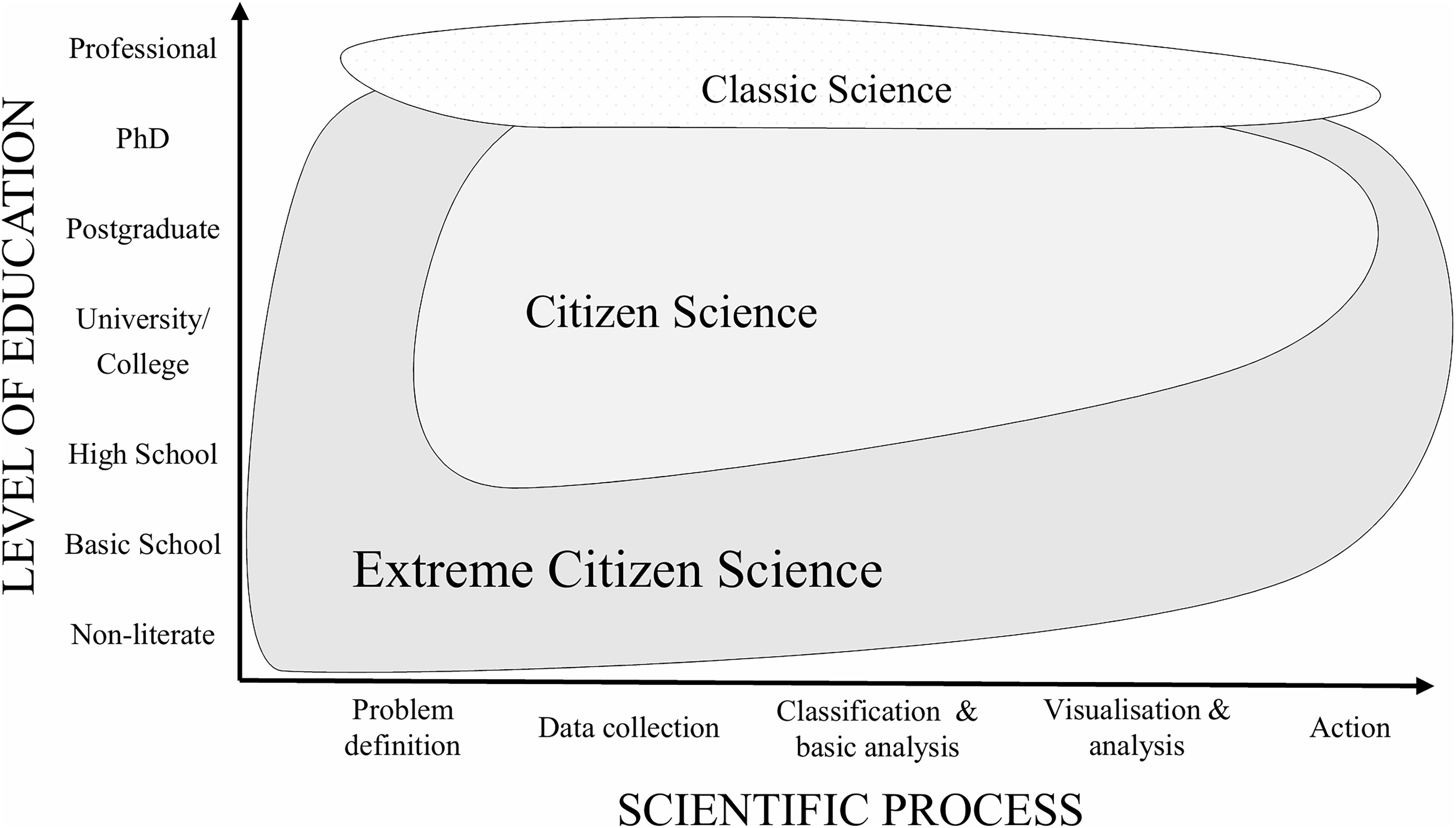
Figure 1. Positioning Extreme Citizen Science (ECS) within the scope of citizen science.
The methodology of ECS is dedicated to giving all people access to the scientific method. It brings together scholars from diverse fields such as anthropologists, conservation biologists, ecologists, geographers, and data scientists to develop and contribute to guiding theories and methodologies that promote citizen engagement to address pressing environmental issues. With an interdisciplinary research approach, the ECS methodology aims to provide a set of tools that can be used by anyone regardless of their background and level of literacy. In summary, the adjective “extreme” conveys that: (1) all people can be included in the scientific process, even those who are non-literate and marginalised, (2) participants are involved throughout the scientific process, from problem-definition to problem resolution, (3) it aims to decolonise research by guiding scientists to act in support of others instead of focussing on their own projects, and (4) that the tools and methodologies work in extreme environments such as dense remote rainforests, deserts or places with limited or non-existent infrastructure, since such places are often home to important biodiversity. It is critical to stress that ECS should be seen neither as a critique of, nor in opposition to other citizen science practices, since there are many situations in which other citizen science approaches are both fit for purpose and suitable for participants’ needs and interests.
But how to enable such levels of engagement? Professional scientists usually conduct their research using a wide range of precision instruments, tools, and machines to record, generate, visualise, and analyse data. In our work we supply non-professional scientists, even when non-literate, with smartphones—if they do not already own one. Given the range of sensors they contain, smartphones are extremely powerful instruments for scientific research, and their ubiquitous use among most human populations makes them a most promising tool for popularising scientific activity. However, to ensure that local users, such as the Congolese hunter-gatherers we first collaborated with, are able to use smartphones to address whatever issues they identify, we have iteratively adapted interfaces for a smartphone application aimed at scientific data collection. Since existing applications (e.g., Open Data Kit) assume literacy, so UCL’s Extreme Citizen Science (ExCiteS) research group developed Sapelli, an open-source mobile data collection and sharing platform designed with a particular focus on including non-literate users with little or no prior experience of Information and Communication Technology (ICT)— “non-literate” is a non-judgemental statement of fact; it differs from “illiterate” which could imply someone has tried to become literate but failed.
The Sapelli platform plays a central role in facilitating the main ECS objective—which is to develop theories, tools, and methodologies to enable any community, anywhere, to engage in local citizen science research, mostly using a process of participatory mapping and inventory. From our research collaborations in the Congo Basin, the Amazon Basin and in other case studies (https://uclexcites.blog/; Skarlatidou and Haklay, 2021) maps have proved to be an accessible format for non-literate people to visualise and analyse the data they collected using Sapelli, and an efficient and appropriate form of communication between groups of different power and means (Lewis, 2012b). The density of information compressed into maps makes evidence quick to access and visually analyse, without the restrictions of linear, logical sequential representations more common in textual documentation that tend to be as often ignored by busy senior managers and decision-makers as they are by non-literate people (Lewis and Nkuintchu, 2012). By sidestepping the limitations of text, such maps provide an alternative medium for understanding the problem and opening up a discussion that avoids many of the barriers to participation facing local and indigenous communities in places such as Central Africa. Such maps can become a medium of empowerment and protest for communities to assert their rights to resources and territories (Peluso, 2005; Lewis and Nkuintchu, 2012; Özden-Schilling, 2016, 2019). In this way, ECS can support local citizen scientists to address for themselves the questions that they initially posed (Haklay and Francis, 2018).
In this paper, we introduce the stages of the ECS methodology, based on the last 13 years of field experiences of participatory design centred on the user (Figure 2). This paper focuses on the deployment of Sapelli as a tool grounded in a methodology which relies on two pillars: the socio-cultural and the socio-technological. The former pillar promotes problem definition carefully adapted to the socio-cultural and environmental context of the people that are engaged in the process through meetings and discussions to identify the foci of work (Stage 1), to explore potential negative and positive consequences to elaborate the Free, Prior, and Informed Consent (FPIC) process (Stage 2). The socio-technological pillar incorporates the participatory icon design and interface evaluation of Sapelli (Stage 3), together with the Community Protocol (CP) that organises the structures and needs of the community in order to collect data and to conduct the research (Stage 4). This approach enables communities to collaboratively create a Sapelli project that is widely understood, easy to use, and which meets the needs of local people. The final stage brings together both pillars to organise appropriate ways to analyse and visualise the collected data and eventually to act upon it (Stage 5). We will provide details of each stage, with reference to case studies in Cameroon, Brazil. By focussing primarily on the ECS methodology to implement Sapelli, we hope to assist others who may wish to use the approach described here.
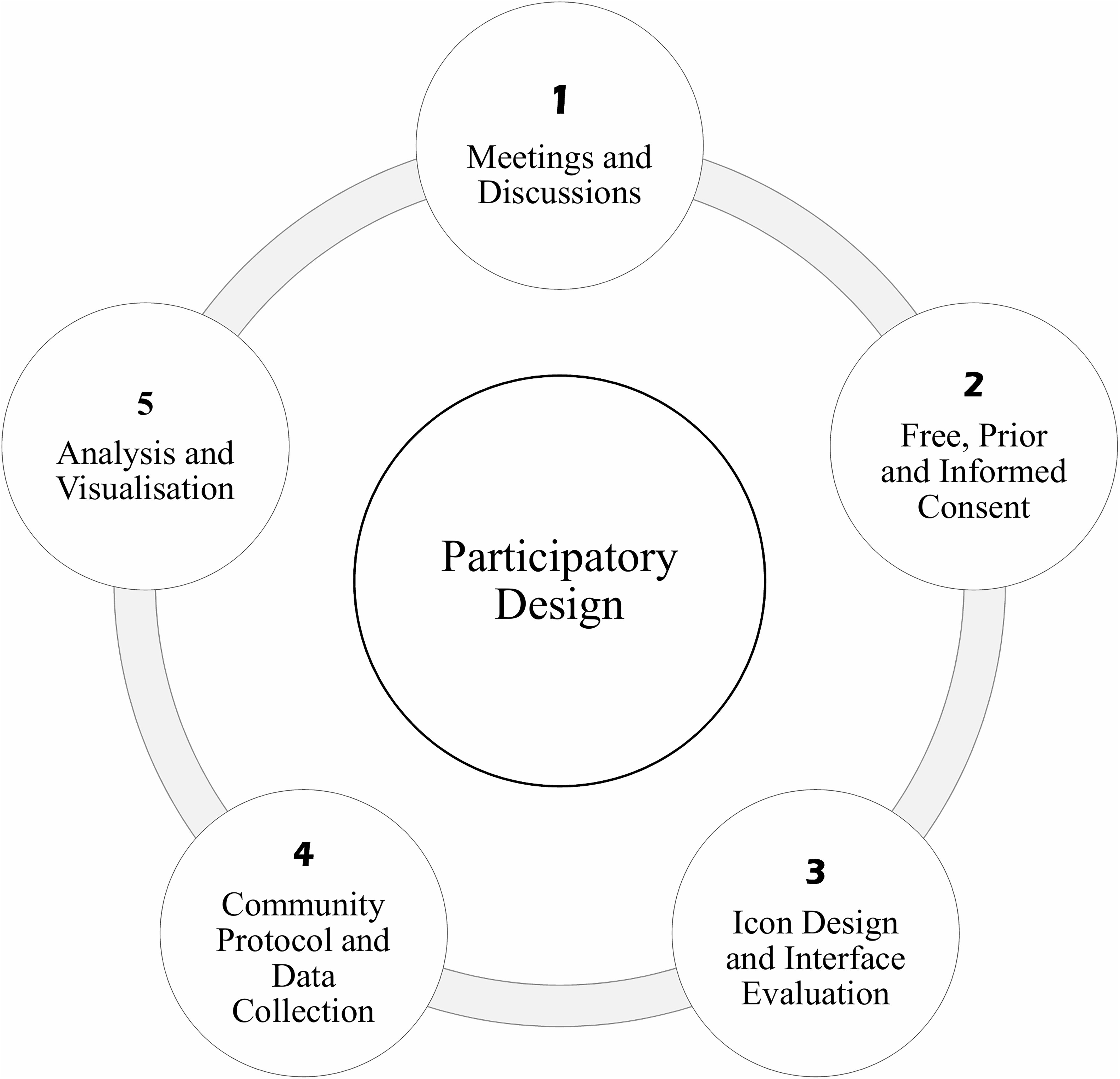
Figure 2. Diagram of the different stages of ECS methodology relying on participatory design.
Sapelli
The Origins
The methodology and approach taken in ECS evolved out of Lewis’ environmental justice and participatory mapping work supporting non-literate indigenous hunter-gatherers in the Congo Basin to better represent themselves and their interests to powerful outsiders such as timber companies and conservation organisations. These outsiders were given rights over indigenous peoples’ and local communities’ (IPLCs) lands and resources by national elites without the consent of the hunter-gatherers (Lewis, 2012b, 2020). To facilitate the highly ecologically literate Congolese hunter-gatherers to map their key resources in 2005 Lewis designed icon-driven software for a rugged handheld computer-GPS unit to overcome their non-literacy. Later, in Cameroon, together with Nkuintchua, Lewis developed an early version of the ECS methodology for working with IPLCs based on FPIC, a project co-design process and an advocacy strategy to support IPLCs to act on their findings. This approach and the device were used successfully in negotiations with multinational timber companies to protect key resources from damage during logging, and also to document illegal logging activities (Lewis, 2007, 2012b; Lewis and Nkuintchu, 2012). In 2009, Haklay introduced Lewis to citizen science, and applied his experience in this domain to guide the development of “Extreme Citizen Science” (ECS) and the Sapelli suit of tools using much cheaper and widely accessible smartphones.
Community Data Sovereignty
The approach we take towards data sovereignty in ECS projects recognises the potential for harm that can be caused by extractivist approaches to data collection by outsiders, and the subsequent misuse of information provided by indigenous peoples or local communities, particularly in white settler society contexts such as New Zealand, Australia, and North America (Kukutai and Taylor, 2016; Lovett et al., 2019). As a consequence, we recognise the importance of ensuring that participants from the indigenous groups and other local communities with whom we collaborate retain full control of the data that they facilitate collecting. This is made more complex in our situation because many of our collaborators have little or no knowledge about the way data can travel and be appropriated for use in ways that those who created the data would deem unacceptable. In such contexts the significance of working with a trusted gatekeeper cannot be under emphasised. During the discussions to develop the CP (Stage 4), the community is supported by their trusted gatekeepers and the ECS facilitators to plan the most effective ways of using the data to achieve community objectives. As this often requires sharing data with outsiders, this is clearly discussed and the acceptable organisations, individuals and modalities for doing so are noted down in the CP, as well as which types of data can be shared. The community will often nominate a trusted gatekeeper to keep them informed about how their data is being used if they cannot verify this themselves (e.g., in the context of wildlife law enforcement). Additionally, sometimes new actors request access to the data. In these cases the trusted gatekeeper or other person acceptable to the community goes to ask permission for the new use or change of use. Only if the community gives consent will the data be used in these new ways. The GeoKey server that ECS has developed was designed to facilitate this level of control and protection (Stage 5). The most significant problem we have faced is that any changes to access or following up on requests for access can sometimes take months to agree because of the remoteness and mobility of communities, and lack of communication infrastructure.
Stage 1: Meeting and Discussions
The ECS methodology is based on the understanding that IPLCs know themselves and their local area best. In this regard, being introduced by a trusted gatekeeper and working with local people in their communities rather than convening workshops in regional centres or cities is prioritised to tackle local issues. The role of professional scientists is to support the process of building a Sapelli project by listening and understanding what IPLCs identify as the challenges they face, and then supporting them to focus on issues that they can address using Sapelli. Applying the iterative and participatory design process ensures that the project is centred on the needs identified by participants and informed by their understanding and knowledge of local ecosystems and their experience within them. Sapelli translates local knowledge into datasets that can be visualised and analysed through maps.
Adapting Sapelli to local needs and cultural practices is one challenge of the ECS methodology, as bringing groups with different backgrounds and cultures to work together requires sensitivity and care. Professional scientists and local communities do not necessarily understand environments in the same way. They do not organise themselves in the same way, nor have the same patterns of value and trust. The collaboration of local communities with newcomers, such as professional scientists, can exacerbate existing tensions related to indigeneity, ethnicity, and gender, or provoke new ones. For instance, dominant groups in Central Africa may feel challenged by the attention indigenous groups get and the issues they document. It can also generate conflict when the causes of environmental damage are profit building for dominant groups. Regular meetings and discussions with participating communities and their allies, in conjunction with the Free, Prior and Informed Consent (FPIC) process (Stage 2) and CP (Stage 3), help negotiate such risks by developing strategies to address them, so improving mutual understanding and trust, and more clearly defining roles and responsibilities. These discussions are an integral part of the ECS methodology (Figure 2).
Often after discussion with a third party facilitator, such as an anthropologist, local community group, NGO or a locally active conservation organisation, an ECS facilitator arrives to begin the ECS process. Initial meetings and discussions between the local community and the professional scientists aim to explore challenges identified by the local community that ECS can address. The visit of the professional scientists to a community should be announced some days prior to the meeting, to both the community and relevant local authorities. It is crucial for initial meetings to be facilitated by someone that is a trusted gate-keeper of the community to ensure as much trust and confidence as possible. During the initial meeting, the professional scientists carefully introduce themselves and the purpose of their visit. We have found that an open-ended discussion on issues facing the local community is the best way to proceed to identify potential areas in which collaboration might be possible. If issues emerge that can be meaningfully addressed using ECS the professional scientists lead a more analytical discussion to identify what types of indicators the community uses to measure the degree of the problem, how such indicators are known and shared, and which actors are implicated in the issues raised. With this information it is possible to assess the feasibility of an ECS project to address the issues raised, what risks the project may entail, and what desirable resolution would be like (Fryer-Moreira and Lewis, 2021).
This discussion lays the foundations for collaboratively developing the ECS methodology. It reveals both the challenges that the community wants to address and the reasons why individuals want to resolve them. Through such a consultative and deliberative process, the community highlights what issues it is concerned about. Characteristics through which the community makes sense of its environment might include customary laws and rights, their Traditional Ecological Knowledge (TEK; Berkes, 1999), cultural and spiritual values, social and ecological norms, but also traditional management practices of their territorial resources. All these characteristics are thoroughly discussed in the community with an emphasis on exploring the ways local understandings can conjoin with ECS whilst maintaining the community’s ontological order to avoid these “being reduced to fit within western concepts”(Reid and Sieber, 2019, p. 216). As far as possible, strategies to assure participatory parity by addressing any power imbalances are employed when carrying out this deliberation (by consulting different groups simultaneously, or creating multiple break out groups to enable all to express themselves) in order to create a socially accepted frame of reference (Lewis and Nkuintchu, 2012).
This is a crucial condition for community engagement as this shared frame will also become an interpretive framework to help solve issues that prevent the project from flourishing. In our experience, the problems selected by communities are related to their environment and cultural identity. With guidance from the ECS team as to what is realistic, the community is invited to specify at least one of the challenges raised and begin to discuss how it can be addressed using the resources and capacities of the community combined with local partners and the ECS approach. This problem definition marks the start of a local citizen science project.
Stage 2: Free, Prior, and Informed Consent
Addressing such a challenge will unsurprisingly impact the lives and livelihoods of the IPLCs concerned by this problem. The FPIC process assumes that these impacts, which could be positive or negative, need to be understood by the community before consent can be requested (Office of the United Nations High Commissioner for Human Rights (OHCHR), 2005). Lewis (2012a) describes in detail how to implement FPIC in the field. He warns us about the different meanings that the concept of consent can imply. In Central Africa for example, consent emerges from a long-term ongoing negotiated relationship based on mutual trust. In other words, consent is a social construction of on-going mutual satisfaction that can be broken if one party ceases to respect their obligations. Although different, such agreements can be documented (using video, photographs, and paper) to formally recognise them as equivalent to a written contract signed by both parties.
In a public FPIC process, community and professional scientists explore and discuss all the potentialities, positives and negatives, that their collaboration might engender. Careful attention to mitigation strategies for negative potentialities must be discussed together with ways to enhance positive outcomes. Once the community has weighed the pros and cons and considered mitigation strategies, it can choose to accept, renegotiate, or refuse to participate in the project. Nonetheless, far from being only a validation, the consent of the community must be negotiated in respect of three points: free, prior, and informed (Lewis et al., 2008). Being able to approve, negotiate or refuse a citizen science project before it commences, without pressure or duress, is key to ensure that the community is “free” and “prior” in its choice to participate. Throughout the ECS project, the community has the right to say “no” and to renegotiate or withdraw their consent. If the community withdraws its consent, their decision is respected and if they request that their data contribution be deleted this is done since they own the data. In our experience such undesirable outcomes are avoided if the community is fully informed; meaning that they understand both positive and negative potentialities and have discussed realistic mitigation and enhancement strategies. A free choice means a well-informed choice (Schlosberg, 2007). For instance, collecting data on illegal poaching may be beneficial for the community, but it also involves risks that poachers may realise the community is monitoring them (Brofeldt et al., 2018; Theilade et al., 2021). Together with participants, the ECS team works out strategies to address such potentialities. In this case, the solution was to create personalised pass symbols to prevent access to the Sapelli project by unauthorised people. Informed consent also requires verification that all stakeholders, including potentially marginalised members of the community, have properly understood information despite linguistic differences, literacy levels, and cultural interpretation (Lewis et al., 2008; Lewis and Nkuintchu, 2012). Finally, the overall FPIC negotiation process must happen before the community could be affected by any possible consequences of the implementation of an ECS project. The earlier the FPIC process is negotiated, the stronger it becomes.
In contexts where IPLCs may be non-literate, it is still vital that the FPIC process is synthesised in a form that thoroughly registers all the outputs of the negotiated points. Although this is necessarily a document—formalised in the “Community Protocol”—it becomes a reference point for the cooperation between the community and the professional scientists. If necessary or appropriate, it can also be used to explain the work to local authorities. This document is returned to throughout the project, and updated, or in some cases, adjusted, as different types of information come to light.
Stage 3: Icon Design and Interface Evaluation
The socio-technological pillar of the ECS method consists of the material extension of the socio-cultural pillar. It relies on the meticulous design of Sapelli based on participatory design (Figure 2). The users and their needs remain at the centre of the design process (Sharp et al., 2019; Skarlatidou and Haklay, 2021). The role of the professional scientist consists in translating the user’s data needs based on their broader socio-cultural and environmental problem definition and local knowledge to support the community to co-design and co-create appropriate data collection interfaces.
Sapelli is an open-source project that facilitates data collection across language or literacy barriers through highly configurable icon-driven user interfaces. It is designed to be used beyond conventional western utilisation to enable people with no or limited literacy to use smartphones and tablets to collect, share, and analyse data (Lewis, 2007, 2012b). Sapelli is available on the Google Play Store or GitHub repositories. All the information needed to build a Sapelli project that is accessible to any user and adapted to their specific requirements are available on the website: www.sapelli.org, but developing a Sapelli project requires basic computer skills. Sapelli is used in a variety of projects, mostly related to environmental monitoring (see https://uclexcites.blog/; Skarlatidou and Haklay, 2021 for details). It enables communities, regardless of social and geographical background, to map their environment and document any problems or threats they face. With Sapelli people can, for instance, not only report environmental crime, geo-tag valuable resources, monitor agricultural industries and chemicals, prepare land claims, but also survey transport users, navigate complex legal systems, or report wheelchair accessibility. As a result, Sapelli can enable any community to develop a project and engage in citizen science on almost any topic.
Participatory icon and decision-tree design enables communities to collaboratively create a bespoke Sapelli project that addresses their issues. The output is a mobile data-collection tool that reflects local needs and desires, set up on accessible digital platforms with customised icons and voice commands. The first step involves the drawing of the pictogram-based decision tree for Sapelli. Guided by the community participants, the professional scientists help to define the specific data types that need to be collected to address the problem. When the community relies on outside agencies to enforce the law, or act on the data the community collects, then these outside agencies also need to participate in the discussion of what data should be collected to ensure that they can be used as evidence to support the community’s objectives. For instance, if the community wants to address illegal poaching, data might include dead animals, cartridge cases or campfires, but also elements such as hidden stashes of ivory. The community, with its rich contextual understanding and local knowledge, is best placed to enumerate the key data points they can collect (Stevens et al., 2014). They are then invited to create drawings on A4 paper, sometimes simply on the ground. Sometimes photographs are taken and turned into icons using graphics software, or simply drawn by members of the scientific team. The drawings are then digitised and tested on the community for accuracy before they become part of the Sapelli interface. This icon testing is done by the professional scientists holding up A4 images and asking the community to tell them what the image means. If the image provokes diverse responses, it needs further work. Only once an image consistently evokes the correct response from participants is it ready to incorporate into the Sapelli design (Fryer-Moreira and Lewis, 2021).
Icon design continues by deciding how icons should be organised in the hierarchical “decision-tree” structure on which Sapelli is based, so that it makes intuitive sense to participants. Although based on a hierarchical structure such as those commonly used in conventional computing applications to organise information, such structures seem to be understandable by non-literate local and indigenous people. Nevertheless, organising data in a hierarchical structure may not always be intuitive and decisions concerning this structure need to be explored together with the community and adapted to their associations. For instance, should the cartridge cases be included in a different category to poacher’s campfires in the decision tree, or rather put at the same level (Vitos et al., 2017)? Answering such a question necessitates input from the community as well as further testing of different icon configurations to ensure they are intuitive to users and well-understood.
Finally, the newly designed Sapelli project needs field testing to evaluate whether there are usability issues which need to be addressed. Traditional usability studies rely heavily on observing how people use an interface while collecting feedback to improve the interface (Dumas and Redish, 1999). To do so in this context, the scientific team goes out on data collecting expeditions with different user groups. In many of the communities that we have worked with men and women have different foci when involved in their normal daily activities, so team members divide up to each accompany a different group as they walk in the local area collecting data (Lewis and Nkuintchu, 2012), or occasionally using different Sapelli configurations in controlled usability testing experiments (Vitos et al., 2017). While walking, the professional scientist discusses with the participants their experience of using the project, and if participants have difficulties, confusions or discover that items they wished to record were not available as options in the decision-tree, this is all noted. In return the team discusses the issues with participants and collectively decides how to address them. This often requires corrections to be made to the Sapelli project. Once the changes are complete the same field-testing process is applied again until participants are satisfied that the project addresses all their needs and expectations. In developing Sapelli, the scientific team conducted additional usability experiments to test assumptions built into the technology, to identify barriers that pose difficulty to users and so improve interaction and the overall user-friendliness of the application (Pejovic and Skarlatidou, 2020; Skarlatidou et al., 2020). Once the final prototype is approved by the community, the users can start to organise to collect data.
Stage 4: Community Protocol and Data Collection
Once the Sapelli project is ready to collect data the process to define who will collect the data, on what terms, when, and with which equipment must be carefully organised. Once data is collected how will it be verified and by whom? Once data is approved where will it be stored and who will get to see it? Here the FPIC discussions that sought ways to minimise the potential for negative outcomes and to enhance the positive ones are an important source of guidance. The CP seeks to pre-empt as many issues as possible from becoming problems by discussing them publicly and formalising the way the community manages them, thereby aiming to ensure the ECS project has the best chance of achieving the expectations of participants and is sustainable. As in the FPIC process and Sapelli design, the CP is a negotiation ensuring that the community and its decisions are at the centre of the process (Fryer-Moreira and Lewis, 2021).
The CP codifies participants’ expectations of the project. It defines the responsibility of individuals as well as the timeframe of data collection and use. With the help of the professional scientists, the community decides by whom, when and how data will be collected, and its quality checked. With whom will they share their data? What are their designated partners allowed to do with the data? Who is responsible for the equipment—keeping phones in good order and batteries charged? What steps will be taken to minimise the risks involved when collecting data? The discussion should focus on three main areas that will support the overall objectives: the technical support, the logistical support, and the data sharing protocols. The technical support should be guided by questions such as what equipment is needed? What are the charging facilities? What is the level of connectivity for data transmission? In situations with little technical infrastructure how will this be assured (memory cards, secure wireless/relay transmission)? When, by whom and where? What happens if a phone breaks or is lost? Questions relating to sensitive issues such as what remuneration participants might receive must be transparently discussed and collectively decided upon in order to reduce the potential for misunderstandings and jealousy later. Finally, the CP clearly recognises that the community own their own data and so they must define who they allow access to the data and on what terms, if elements of it can be shared and on what basis, who will host the data and who is permitted access to it. Due to the infrastructural challenges that can make communication difficult or slow, and the lack of literacy among the majority of the indigenous groups we work with, they can choose to delegate certain responsibilities relating to their data to trusted others.
As in the FPIC process, the CP can be synthesised into a form reflecting the output of the negotiation process. It summarises all the practices, procedures and rules developed by a local community to govern their interaction with Sapelli in their environment and with other people such as government officials, conservationists, logging companies, local community-based organisations, the professional scientists, and any other groups concerned by the project.
Stage 5: Analysis and Visualisation
The final stage brings together the socio-cultural and socio-technological pillars to consider appropriate ways to validate, share and act upon the data that are gathered. Our research has shown that non-literate people do understand maps of their environment with little or no guidance, especially aerial or hi-resolution space imagery (Altenbuchner, 2018). Unsurprisingly, once they have collected data, participants wish to visualise it. Not being able to instantly view the collected data was considered to be a major frustration for participants, which can demotivate them from collecting further data using Sapelli (Comandulli, 2021). While addressing this is the current focus of the UCL ExCiteS group’s further development work, currently the professional scientists or organisations supporting participating communities must share the collected information back with participants. This visualisation on a map is the last step of the scientific process as the participant will be able to validate and analyse the data collected, begin to formulate an answer to their research question, and decide how to act upon it.
Geokey Server and Community Maps
The data collected with Sapelli Collector can be transmitted to the GeoKey server and then visualised in the mobile-friendly Community Maps web map (see www.sapelli.org; https://geokey.org.uk/; https://communitymaps.org.uk/; Ellul et al., 2009 for details). GeoKey is an open data infrastructure for community mapping that provides opportunities for participatory mapping (Roick et al., 2016). This platform serves as a connecting point between data collection and data visualisation and provides the functionality to edit and comment existing data and add new contributions using points, lines, polygons, text, the Sapelli Project icons, and media files.
As noted above, technological and knowledge disparities mean that the responsibility for ensuring that the information is protected and shared under the agreed terms of the CP only resides with the researchers or field workers who established the project with the community. Data, and especially sensitive data, must be protected and used for carefully. In cases where the data is only used in the field and where data is extracted from the mobile phones in the form of files, data can be managed by the field team. In cases where the information is stored on a remote server such as the GeoKey server, there are several issues that need to be considered. While the encryption of an individual record is not yet possible, the database that stores the information is set on an encrypted drive, and uses a whole database encryption. Finally, a password is used to protect the GeoKey server that is linked to the Sapelli project, and only authorised users can access the data.
Though Community Maps was created with a deliberately simple design to support community mapping in different situations and it plays a key role in enhancing collaboration between groups with different backgrounds and education, the participants in the case studies described here and others do not visualise and analyse regularly the data collected in Community Maps due to, among other, the need of fast internet speed, email registration (if the data is password protected) or literacy barriers. This highlights the technological gap that the ECS methodology aims to address. That is, the need for a visualisation tool (see below) that, on the one hand allows for the validation and analysis of the data collected in real time, regardless of connectivity, and the participant’s level of literacy, technical skills and previous experience in interacting with maps. On the other hand, the tool needs to allow for data sharing between members of the same or other communities and stakeholders when access to the internet is an option. Whilst internet access in rural areas in developing countries is increasing (International Telecommunication Union (ITU), 2020), factors such as internet speed to load online maps or Earth Observation (EO) imagery, transmit media files, the cost of being connected, or the storage capacity of the devices (offline use) must be taken into account when implementing Geospatial and Information and Communication Technologies (Geo-ICTs) in such contexts.
Similarly, the volume of freely available high spatial and temporal resolution EO data is increasing exponentially, and this brings opportunities for improving the quality of hybrid base maps (satellite or aerial imagery and thematic maps) which provide not only critical contextual information to analyse the data collected in visualisation tools (Altenbuchner, 2018), but also critical awareness of human impacts on the Earth’s surface as changes can now be seen from above, sometimes in near-real time, as never before. The positive impacts of emerging synergies between citizen science and Digital Earth are widely acknowledged (Brovelli et al., 2020), but it is worth reiterating that the democratisation of EO data use is not a reality. It is important to note that, monitoring land use and land cover changes at near-real time using manual image interpretation methods often requires access to recent and very high spatial resolution (i.e., pixel size less than 1 m2), however, such imagery is currently not freely available, especially in non-urban areas in developing countries.
Sapelli Viewer
Current research efforts focus on the development of a “Sapelli viewer,” an application that aims to address the gaps identified above and enhance the appropriateness of the system in order to meet the needs of the communities. The challenges are significant, and expectations must be managed accordingly, especially considering the limitations of long-term research (software) projects to address short-term local needs. Sapelli viewer is designed to allow participants without technical literacy to view the data that they are collecting (Figure 3). The final version of Sapelli will bring the data collector functionality together with the visualisation functionality in a single smartphone application. Similarly to the data collection tool, the design, development, implementation, and evaluation of Sapelli viewer relies on an iterative, participatory design process. Eventually Sapelli viewer will support end-users, not only to view and validate the data they collect, but also to explore the data by running more advanced analysis functionalities such as viewing changes over time.
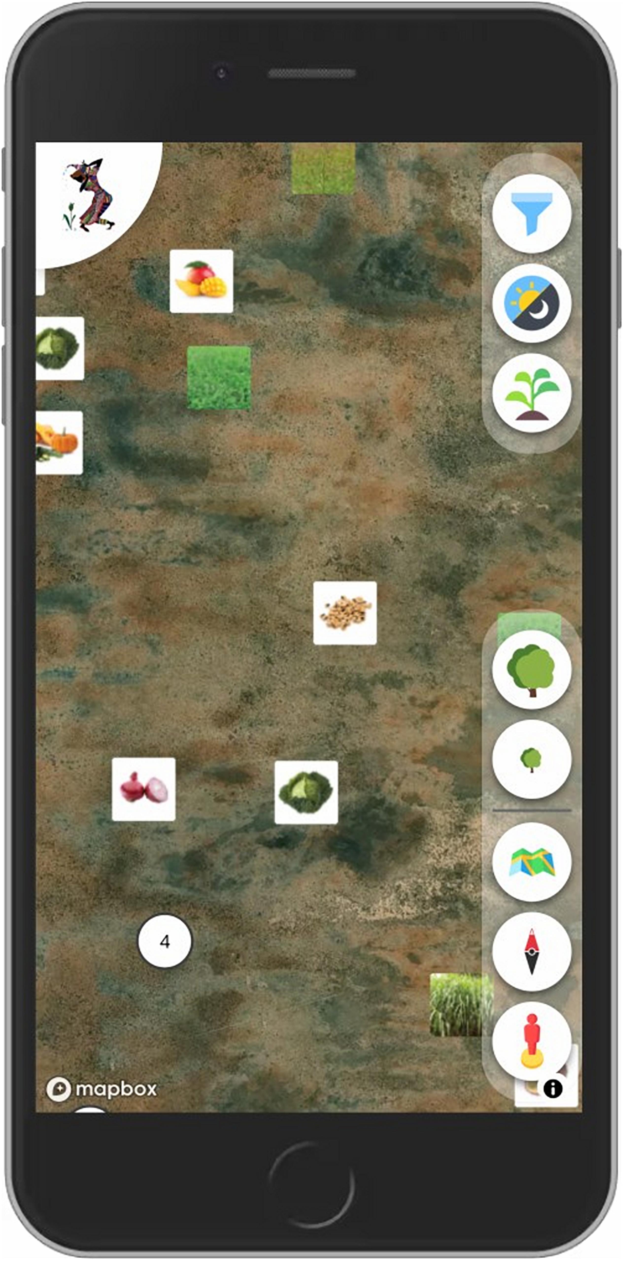
Figure 3. Sapelli viewer (prototype with basic viewing functionality).
Two Case Studies
Meeting, Discussions, and FPIC Process in Cameroon
In comparison to the academic landscape when Linda Tuhiwai Smith’s Decolonising Methodologies was first published in 1999 (Smith, 1999), the rights of communities involved in research projects or other forms of interventions is a subject that is now receiving a significant amount of attention (Tilley, 2017; Kouritzin and Nakagawa, 2018; Brittain et al., 2020). Those who are most vulnerable to negative outcomes of such work are often indigenous and local communities, and several international mechanisms serve to provide protection and best practice, particularly the United Nations Declaration on the Rights of Indigenous Peoples (UNDRIP). The key foundation of UNDRIP is the FPIC process, intended to ensure that communities have the opportunity to consider and either accept or deny proposals that will affect them (United Nations, 2007). Implementing the process of FPIC is not a simple matter of box ticking, but a purposely long, ongoing, and open discussion (Lewis, 2012a). The process does, unfortunately, get abused (see, for example, Clarke, 2019) which is perhaps no surprise given that UNDRIP is not legally binding (though other mechanisms which support FPIC such as the Convention on Biological Diversity and International Labour Organisation Convention are) and it can be at odds with the interests of extractive industries (Franco, 2014) and settler-dominated governments such as the United States, Canada, New Zealand, and Australia who voted against the adoption of UNDRIP.
In Cameroon, indigenous Baka communities are rarely consulted in interventions that will affect their lives and their forest (Pyhälä, 2012). The emphasis on extracting wealth from Cameroon’s rainforests and wildlife, often to the detriment of Baka and other local communities’ territories, resources, health, and wellbeing continues to accelerate despite increasing awareness of this. Their marginalisation from local, national and international elites’ decision-making processes, and their continued disregard by international development organisations reveals the widespread discrimination they face and that FPIC methodologies are rarely applied (Lewis, 2020).
Since August 2016, the ECS group has been carrying out citizen science initiatives alongside indigenous Baka hunter-gatherer and local Bulu farming communities in the south-eastern forested region of Cameroon in collaboration with the Zoological Society of London (Hoyte, 2020) and the World Wide Fund for Nature (WWF). Twenty-two communities around two key areas in the South and East provinces of Cameroon were consulted on their use of the forest and their associated concerns. This formed the beginning of the FPIC process, following the methodology described in Lewis (2012a) and Lewis and Nkuintchu (2012), the project was not pre-designed or imposed upon communities, but rather time was spent understanding local concerns and building trust. Researchers, rather than community members, had to adapt to local decision-making processes, such as allowing the space and time for Baka egalitarian structures of collective discussion to take their course. The project was introduced in communities where anger over illegal wildlife trade or exclusionist conservation was evident and community members expressed the wish to be involved in addressing such issues, totalling 13 communities out of the 22 consulted, and engaging with roughly 78 active community members.
Community input was continuously encouraged, and as Sapelli software was co-designed over time, community members were consulted on why certain aspects were important and what the function was. This culminated in a broad range of socio-environmental attributes for which data would be collected, from wild fruiting trees to poachers’ camps, to births and deaths in the village and the documentation of forest spirits. A key focus was on ensuring that those involved understood both the potential benefits and risks of involvement. In such a corrupt context as Cameroon, it is common that envisaged benefits simply do not materialise and discussing this possibility in an open way avoids raising unrealistic expectations. Similarly, risks of safely managing expensive technology (one smartphone per community), collecting data on sensitive matters amongst other risks must be explored honestly and mitigation measures established together. Although the FPIC process continues throughout the life of the initiative, an FPIC agreement was signed or recorded which detailed these complexities as well as the right of community members to change or leave the initiative at any time. Direct impact, on reducing the wildlife trade in particular, is hard to quantify, partly due to a lack of quantitative data in relation to the trade in Central Africa in general. However, testimonies from law enforcement staff attest to the direct contribution of citizen data to inform local forestry authorities, law enforcement patrols and international agents (TRAFFIC, Interpol) on the types of activities, frequencies and parties involved in poaching and trafficking for the illegal wildlife trade. It is used to guide the Ministry of Forestry (MINFOF) enforcement officers on the ground, increasing teams from 6 to 8 members or extending their duration. Some MINFOF control posts have been relocated to better tackle traffickers and camping, and patrolling materials for mobile staff have been improved upon. These actions have had tangible results: seizures and arrests have increased due to discrete and precise information supplied through the local community networks. Between 12/2017 and 08/2020, 36 arrest incidents, sometimes of multiple perpetrators, and 19 seizures without arrests were recorded. Communities themselves, through an evaluation methodology known as Most Significant Change, have testified to the reduction in wildlife crime in their localities and the empowering effects of involvement: “What we could not openly speak about, we can now report.”
Icon Design, Interface Evaluation and Community Protocol in Brazil
The communication between researchers or practitioners and local people is not as straightforward as most conservation or development initiatives assume it to be. Cultural or language barriers often create challenges to projects, even when the objective is to support local communities themselves. To mitigate this during the implementation of Sapelli it is vital to allow people sufficient time and information to choose the best strategies, icons and decision tree that best represents their own reality. This case study from the Western Border of the Pantanal wetland, Brazil, illustrates this well.
Between the 1990s and early 2000s several traditional fishery communities in the region were displaced from their original settlements due to the creation of strictly protected areas in the region (Chiaravalloti, 2019). Conservation managers accused them of overfishing local fish stock (Franco et al., 2013).
Supported by a local development human rights NGO, local fishers decided that it would be important to present their understanding of how they manage resources in the region and the boundaries of their traditional territory. Thus, Sapelli was employed to support local people to record their fishing strategies and the boundaries of their community territory in a scientifically valid way. Between January and July 2014, the ECS was adapted to local people’s needs and between August 2014 and February 2015 two families of fishermen collected data. Four smartphones were brought to the local communities and people were trained how to use it, since most of them did not have previous experience with smartphones.
However, although the goal of the project was very clear, and the lead researcher had long experience working with local people, the first prototype created for them to record the data was not understood by local people. Participants found it challenging to navigate across several screens to record a single item in a specific geographic location. Thus, a new version of Sapelli was co-developed which included a simplified decision-tree, reducing the steps before reaching the end of a branch of the decision tree.
After reaching community consensus on the data collection process in the new Sapelli project, another major interaction barrier emerged. The first version of Sapelli was built using pictograms with caricatured images of the monitoring target (fish and crabs). This was a mistake, as the ecological knowledge of the fishers was very detailed, and they complained that the pictograms were too imprecise (Lewis, 2012b; Nyadzi et al., 2020). However, local fishers thought that the pictograms were too imprecise to accurately represent the fish or bait they were seeing. So they asked to have pictograms that precisely represented the key identificatory features of the actual species they sought to monitor. The pictograms were then replaced with scientific illustrations of the two most common fish (Pacu—Piaractus mesopotamicus and Pintado—Pseudoplatystoma corruscans) and two most common bait fish (Tuvira—Gymnotus sp. and Caranguejo—Dilocarcinus pagei) in the Pantanal (Chiaravalloti, 2021).
The last challenge was related to the lack of infrastructure in the region. The community is located in an isolated area of the Pantanal wetland where there is no electricity nor phone and internet connection. Therefore, instead of programming the software to send the data through wireless connection, an intermediary had to, every 20 days, bring a laptop to the community, download the data from the phones, return to the office, up-load the data onto a mapping platform, print out the maps, and return the data to local people for verification and approval.
Although the whole process of adapting the software, returning, and verifying the data, and explaining the results to local people was time-consuming, fishers felt their territory was well represented on the maps. Supported by local NGOs, the results were presented to the Federal Prosecutors’ Office in Brazil, who validated the claims the fishers had made using Sapelli data. The maps they had created from collected data were so persuasive that the Federal Prosecutor demanded that the protected area managers respect the boundaries of the fishers’ territories as represented on the maps they had made. After 4 years of negotiation, local fishers gained official tenure rights to a large part of their territory (2,000 km2). Although it does not fully meet their needs, it was an important victory in terms of community empowerment and ensuring sustainable livelihoods for them.
Insights From the Case Studies
The strategy of ECS is based on the principle that the local community, with appropriate support when needed, is best placed to lead the process of solving the challenges it faces. To get the most out of this process, regular communication between stakeholders must remain at the core of the citizen science activity. In ECS, participatory design assumes that reciprocal recognition and status equality between the professional and the non-professional scientists enable them to build a flourishing and resilient long-term cooperation. The methodology of ECS deployment is therefore open-ended and deliberately leaves ample space for co-design, co-creation, local leadership, and capacity building. We believe that this approach is adapted to give all people, including non-literate people, access to science and the capacity to take action on issues that they are concerned about.
However, the ECS methodology has its limitations. It should be clear from our different case studies that each methodological stage is heavily influenced by the specific context. Local conditions are constitutive parts of the ECS methodology which is designed to be flexible enough to adapt to these variables. Thus, the ECS methodology is first and foremost explorative, experimental, and cumulative. To implement Sapelli in the field, professional scientists have to face uncertainty in terms of what the community and the context will require of them and avoid “railroading” the process to their conceived goal. They need to deal with slow starts, unexpected changes, expect setbacks and deal with the slow process of building trusted relationships.
One important difficulty that we have experienced is a result of combining a project that is fundamentally research-centred with instigating direct action on the ground. Whilst implementing Sapelli projects comes with many challenges these are integral to the research and interesting to document and eventually work to address. However, the very nature of Sapelli is to be deeply embedded in the concerns and priorities of communities, and to resolve these often requires action on the part of authorities that have little interest in attending to community concerns. Nkuintchua developed a specific advocacy methodology to address this (see Lewis and Nkuintchu, 2012) that includes peer-to-peer meetings between participating communities to develop shared messaging and engagement strategies with official representatives. When conducting meetings where community representatives present their data, we invite line managers or bosses to meetings with officials. When sensitive data such as criminal activities are being presented it is necessary to incorporate external oversight into meetings. This is most effectively achieved by inviting funders and other influential individuals to attend to ensure conversations remain constructive, positive, and collaborative.
Expectations for the technology we experimented with also presented problems. People expect gadgets and software to work. When things malfunction and a “quick fix” is not possible due to a lack of resources (most often access to a software developer), external collaborators and community members can get quickly frustrated. The expectations of community members and in-country partners, who may often presume that the technology is faultless have to be managed appropriately from the outset.
Developing a fully functional project requires considerable commitment in time, effort, and relative costs (e.g., the cost of smartphones and access to the mobile network, and the cost of the installation and use of GeoKey). These elements cannot be quantified since they depend so much on the context the collaborating communities find themselves in. The work of listening to the issues they identify and co-designing a Sapelli project, then working through the CP as described here can be achieved in a relatively short time depending on the context - sometimes in just a few days. However, the relationship is ongoing and there will still be a need for regular contact with the community to troubleshoot technical issues, adapt software to new scenarios, incorporate new items for data collection, inform them of new requests for access to the data they collected, or of new uses of it that could be to their advantage (e.g., incorporating elements of it onto an online platform) to support. While these are predictable inputs, by far the most time consuming and unpredictable elements have been in identifying partners to support achieving community goals (e.g., the Ministry of Forestry in Cameroon) and the negotiations that this entails.
Our case studies have shown that all ECS experiences have not fully succeeded in the way they were intended. The main limitation of the methodology is the complexity and unpredictability of the networks of relations that professional scientists need to cultivate and maintain to achieve community-defined objectives. In conjunction with close and ongoing relationships with local participating communities, effective working relationships are required with government and enforcement agencies, businesses, conservation, and other locally present organisations, in order that appropriate follow-up actions occur. To promote sustainable collaboration, it is therefore important that professional scientists partner with intermediaries who can provide support and maintain connections with local communities and the other stakeholders when they are absent. Professional scientists must also ensure that the local communities are updated if the ways that the collected information will be used or the implications of such use change after the original FPIC and CP discussions. Due to the power and knowledge differences, it is the responsibility of the professional scientists or whoever participating communities have nominated to act as custodians of the information, to act in good faith, and respect community consent as an ongoing process, and never completed.
Such factors impose limitations on the use of community collected information, but this is in line with an ethical commitment to the participants. Finally, professional scientists must provide regular feedback and have in place the means to share important information with participants in a timely way. The development of Sapelli viewer will contribute greatly to enabling participants to visualise and analyse their data on maps while giving them more autonomy to create dialogues not only with professional scientists but also with other communities and stakeholders.
Conclusion
This article provides an overview of the participatory design process used in Sapelli-based ECS projects in the field. The methodology of ECS starts with a dialogue to identify the needs and concerns of potential participants in their local community. If these concerns might be realistically addressed using ECS, professional scientists work together with local people to design an ECS project and support them to implement it in their community to address issues of local concern. Although potential implementations of the technology and the process have been developed in contexts in which technical and literacy levels are low, the process has also worked well when collaborating with highly educated participants such as wheelchair users in London, or environmental lawyers in Ghana.
We have outlined the five main stages in the design process that can enable people to develop and run a Sapelli project. An active collaboration between professional scientists and local communities through meetings and discussions (Stage 1) addresses the socio-cultural context in which the community is living, and identifies the challenge/s the community wants to address using an ECS approach. The FPIC process (Stage 2) ensures that the community is aware of the possible negative or positive consequences if they decide to participate in the ECS project, and how these can be mitigated or enhanced. This characteristic of open negotiation is extended into the technological design and implementation methodology of the Sapelli project. The Sapelli decision-tree and icons are then designed following people’s recommendations through icon design and interface evaluation (Stage 3). The CP thoroughly organises and outlines the data collection and data sharing process by taking into account the material, institutional and environmental constraints (Stage 4). Finally, the collected data are shared with those individuals or organisations that participants have permitted to view it. A visualisation tool named Sapelli viewer, currently under development, will enable people to visualise, validate and analyse their data and eventually develop actions based on these analyses (Stage 5).
In outlining the ECS methodology in this paper, we wish to emphasise that this methodology is open-ended so that others who may wish to use the approach, can adapt or improve it according to their project specificities and local contexts of use [see https://preylang.net/for a very successful adaptation, also described in Brofeldt et al. (2018) and in Theilade et al. (2021)]. Worldwide, there are 1.3 billion forest-dependent people whose territories protect much of the remaining biodiversity on Earth (Sobrevila, 2008; Pretty et al., 2009; Porter-Bolland et al., 2012), a rural population of 3.4 billion and more than 750 million adults, of whom two-thirds are women, who are unable (or choose not to) to read and write (UNESCO, 2015; Macqueen and Mayers, 2020). Sapelli has great potential to be deployed in multiple contexts, and to empower people to explore and tackle the challenges they face locally.
Data Availability Statement
The original contributions presented in the study are included in the article/supplementary material, further inquiries can be directed to the corresponding author.
Author Contributions
FM led the publication. MH, JL, AA, MM, RC, and SH contributed to writing and reviewing the manuscript. AS, AV, CC, EN, MV, JA, ML, RF-M, and DA contributed to reviewing the manuscript. All the authors have contributed to the development of Sapelli. All authors have read and agreed to the published version of the manuscript.
Funding
This project has received funding from the European Research Council (ERC) under the European Union’s Horizon 2020 research and innovation programme (Grant agreement Nos. 694767 and ERC-2015-AdG).
Conflict of Interest
The authors declare that the research was conducted in the absence of any commercial or financial relationships that could be construed as a potential conflict of interest.
Acknowledgments
We wish to acknowledge all the community members around the world who collaborate with us. They play a central role in helping to shape the implementation of Sapelli. We feel it essential to include community members as co-authors, however, for this manuscript, those who were consulted decided against adding their names due to security concerns.
References
Altenbuchner, J. (2018). Towards Inclusive GIS in The Congo Basin: An Exploration of Digital Map Creation and an Evaluation of Map Understanding by Non-Literate Hunter-Gatherers. London: University College London.
Berkes, F. (1999). Sacred Ecology: Traditional Ecological Knowledge and Resource Management. Milton Park: Taylor & Francis.
Bonney, R., Cooper, C. B., Dickinson, J., Kelling, S., Phillips, T., Rosenberg, K. V., et al. (2009). Citizen Science: a developing tool for expanding science knowledge and scientific literacy. BioScience 59, 977–984. doi: 10.1525/bio.2009.59.11.9
Brittain, S., Ibbett, H., Lange, E., Dorward, L., Hoyte, S., Marino, A., et al. (2020). Ethical considerations when conservation research involves people. Conserv. Biol. 34, 925–933. doi: 10.1111/cobi.13464
Brofeldt, S., Argyriou, D., Turreira-García, N., Meilby, H., Danielsen, F., and Theilade, I. (2018). Community-based monitoring of tropical forest crimes and forest resources using information and communication technology – experiences from Prey Lang, Cambodia. Citizen Sci.: Theory Pract. 3:4. doi: 10.5334/cstp.129
Brovelli, M. A., Ponti, M., Schade, S., and Solís, P. (2020). “Citizen science in support of digital earth,” in Manual of Digital Earth, eds H. Guo, M. F. Goodchild, and A. Annoni (Berlin: Springer), 593–622. doi: 10.1007/978-981-32-9915-3_18
Chiaravalloti, R. M. (2019). The displacement of insufficiently ‘traditional’ communities: local fisheries in the pantanal. Conserv. Soc. 17:173. doi: 10.4103/cs.cs_18_58
Chiaravalloti, R. M. (2021). “Representing a fish for fishers: geographic citizen science in the Pantanal wetland, Brazil,” in Geographic Citizen Science Design: No one Left Behind, eds A. Skarlatidou and M. Haklay (London: UCLPress).
Clarke, C. (2019). In and Around Cameroon’s Protected Areas: A Rights-Based Analysis of Access and Resource Use Agreements Between Indigenous Peoples and the State. Moreton-in-Marsh: Forest Peoples Programme.
Comandulli, C. (2021). “Digital technology in the jungle: a case study from the Brazilian Amazon,” in Geographic Citizen Science Design: No One Left Behind, eds A. Skarlatidou and M. Haklay (London: UCLPress).
Daguitan, F., Mwangi, C., and Tan, M. (2019). “Future Data and Knowledge Needs,” in Global Environment Outlook—GEO-6: Healthy Planet, Healthy People (Nairobi: United Nations Environment Programme).
Dumas, J. S., and Redish, J. C. (1999). A Practical Guide to Usability Testing, 1st Edn. Bristol: Intellect Books.
Ehrlich, P. R., and Ehrlich, A. H. (2013). Can a collapse of global civilization be avoided? Proc. R. Soc. B: Biol. Sci. 280:20122845. doi: 10.1098/rspb.2012.2845
Ekins, P., Gupta, J., and Boileau, P. (2019). Global Environment Outlook: GEO-6: Healthy Planet, Healthy People. Nairobi: United Nations Environment Programme.
Ellul, C., Haklay, M., Francis, L., and Rahemtulla, H. (2009). “A mechanism to create community maps for non-technical users,” in Proceeding of the 2009 International Conference on Advanced Geographic Information Systems & Web Services. 129–134. doi: 10.1109/GEOWS.2009.20
Franco, J. (2014). Reclaiming Free Prior and Informed Consent (FPIC) in the Context of Global Land Grabs. Amsterdam: The Transnational Institute (TNI).
Franco, J. L., Drummond, J. A., Gentile, C., and Azevedo, A. I. (2013). Biodiversidade e Ocupação Humana do Pantanal Mato-Grossense: Conflitos e Oportunidades. Garamond.
Fryer-Moreira, R., and Lewis, J. (2021). “Methods in anthropology to support the design and implementation of geographic citizen science,” in Geographic Citizen Science Design: No One Left Behind, eds A. Skarlatidou and M. Haklay (London: UCLPress).
Haklay, M. (2013). “Citizen science and volunteered geographic information: overview and typology of participation,” in Crowdsourcing Geographic Knowledge, eds D. Sui, S. Elwood, and M. Goodchild (Dordrecht: Springer Netherlands), 105–122. doi: 10.1007/978-94-007-4587-2_7
Haklay, M., and Francis, L. (2018). “Participatory GIS and community-based citizen science for environmental justice action,” in The Routledge Handbook of Environmental Justice, eds R. Holifield, J. Chakraborty, and G. Walker (London), 297–308. doi: 10.4324/9781315678986-24
Haklay, M., Mazumdar, S., and Wardlaw, J. (2018). Citizen Science for Observing and Understanding the Earth. In Earth Observation Open Science and Innovation. Berline: Springer International Publishing, 69–88.
Howe, J. (2006). The Rise of Crowdsourcing. Wired. Available online at: https://www.wired.com/2006/06/crowds/ (accessed June 6, 2021).
Hoyte, S. (2020). “Cameroon: confronting environmental injustice and illegal logging in the rainforest through indigenous-led technology,” in Minority and Indigenous Trends 2020: Focus on Technology (Minority Rights Group International).
International Telecommunication Union (ITU) (2020). Measuring Digital Development: Facts and Figures. Geneva: International Telecommunication Union.
Johnson, N., Alessa, L., Behe, C., Danielsen, F., Gearheard, S., Gofman-Wallingford, V., et al. (2015). The contributions of community-based monitoring and traditional knowledge to arctic observing networks: reflections on the state of the field. Arctic 68, 28–40. doi: 10.14430/arctic4447
Johnson, N., Druckenmiller, M. L., Danielsen, F., and Pulsifer, P. L. (2021). The use of digital platforms for community-based monitoring. BioScience 71, 452–466. doi: 10.1093/biosci/biaa162
Kouritzin, S., and Nakagawa, S. (2018). Toward a non-extractive research ethics for transcultural, translingual research: perspectives from the coloniser and the colonised. J. Multilingual Multicult. Dev. 39, 675–687. doi: 10.1080/01434632.2018.1427755
Kukutai, T., and Taylor, J. (eds) (2016). Indigenous Data Sovereignty: Toward an Agenda. Canberra: ANU Press.
Lewis, J. (2007). Enabling forest people to map their resources and monitor illegal logging in Cameroon. Hunter Gatherer Res. 2, 1–7. doi: 10.3828/bfarm.2007.2.3
Lewis, J. (2012a). “How to implement free, prior and informed consent (FPIC),” in Biodiversity and Culture: Exploring Community Protocols, Rights and Consent, Vol. 65, eds K. Swiderska, H. Shrumm, W. Hiemstra, M. J. Oliva, K. Kohli, and H. Jonas (Participatory Learning and Action (PLA)), 175–178.
Lewis, J. (2012b). Technological leap-frogging in the congo basin, pygmies and global positioning systems in Central Africa: what has happened and where is it going? Afr. Study Monogr. 43, 15–44.
Lewis, J. (2020). Living with the forest. Sci. Am. 322, 54–63. doi: 10.1038/scientificamerican0520-54
Lewis, J., Freeman, L., and Borreill, S. (2008). Free, Prior and Informed Consent and Sustainable Forest Management in the Congo Basin: A Feasibility Study Conducted in the Democratic Republic of Congo, Republic of Congo and Gabon Regarding the Operationalisation of FSC Principles 2 and 3 in the Congo Basin. Intercooperation, Swiss Foundation for Development and International Cooperation, Berne and Society for Threatened Peoples Switzerland. Available online at: https://www.gfbv.ch/wp-content/uploads/kongobecken-bericht-en.pdf (accessed June 6, 2021).
Lewis, J., and Nkuintchu, T. (2012). “Accessible technologies and FPIC: independent monitoring with forest communities in Cameroon,” in IIED Biodiversity and Culture: Exploring Community Protocols, Rights and Consent, Vol. 65, ed. K. Swiderska 151–165. Available online at: https://pubs.iied.org/pdfs/G03408.pdf
Liebenberg, L., Steventon, J., Brahman, N., Benadie, K., Minye, J., Langwane, H., et al. (2017). Smartphone Icon User Interface design for non-literate trackers and its implications for an inclusive citizen science. Biol. Conserv. 208, 155–162. doi: 10.1016/j.biocon.2016.04.033
Lovett, R., Lee, V., Kukutai, T., Cormack, D., Rainie, S., and Walker, J. (2019). “Good data practices for indigenous data sovereignty and governance,” in Good Data, eds A. Daly, K. S. Devitt, and M. Mann (Institute of Network Cultures), 26–36.
Macqueen, D., and Mayers, J. (2020). Unseen Foresters: An Assessment of Approaches for Wider Recognition and Spread of Sustainable Forest Management by Local Communities. Gland: WWF.
Nyadzi, E., Werners, S. E., Biesbroek, R., and Ludwig, F. (2020). Techniques and skills of indigenous weather and seasonal climate forecast in Northern Ghana. Climate and Development, 0, 1–12. doi: 10.1080/17565529.2020.1831429
Office of the United Nations High Commissioner for Human Rights (OHCHR) (2005). Standard Setting: Legal Commentary on the Concept of Free, Prior and Informed Consent. Commission on Human Rights.
Özden-Schilling, T. (2019). Cartographies of consignment: first nations and mapwork in the Neoliberal Era. Anthropological Q. 92, 541–573. doi: 10.1353/anq.2019.0025
Özden-Schilling, T. C. (2016). Salvage Cartographies: Mapping, Futures, and Landscapes in Northwest British Columbia. Cambridge, MA: Massachusetts Institute of Technology. Ph.D. thesis.
Parlee, B., and Manseau, M., and Łutsël K’é Dene First Nation. (2005). Using traditional knowledge to adapt to ecological change: denésołiné monitoring of caribou movements. Arctic 58, 26–37.
Pejovic, V., and Skarlatidou, A. (2020). Understanding interaction design challenges in mobile extreme citizen science. Int. J. Hum.–Comput. Interaction 36, 251–270. doi: 10.1080/10447318.2019.1630934
Peluso, N. L. (2005). “Whose woods are these? counter-mapping forest territories in Kalimantan, Indonesia,” in The Anthropology of Development and Globalization: From Classical Political Economy to Contemporary Neoliberalism, eds M. Edelman and A. Haugerud (Hoboken, NJ: Blackwell Pub).
Porter-Bolland, L., Ellis, E. A., Guariguata, M. R., Ruiz-Mallén, I., Negrete-Yankelevich, S., and Reyes-García, V. (2012). Community managed forests and forest protected areas: an assessment of their conservation effectiveness across the tropics. For. Ecol. Manag. 268, 6–17. doi: 10.1016/j.foreco.2011.05.034
Pretty, J., Adams, B., Berkes, F., Athayde, S. F., Dudley, N., Hunn, E., et al. (2009). The intersections of biological diversity and cultural diversity: towards integration. Conserv. Soc. 7:100. doi: 10.4103/0972-4923.58642
Pulsifer, P., Gearheard, S., Huntington, H. P., Parsons, M. A., McNeave, C., and McCann, H. S. (2012). The role of data management in engaging communities in Arctic research: overview of the Exchange for Local Observations and Knowledge of the Arctic (ELOKA). Polar Geogr. 35, 271–290. doi: 10.1080/1088937X.2012.708364
Pyhälä, A. (2012). Cameroon: What Future for the Baka? Indigenous Peoples’ Rights and Livelihood Opportunities in South-East Cameroon (No. 13; p. 69). IWGIA - International Work Group for Indigenous Affairs. Available online at: https://www.iwgia.org/en/resources/publications/308-human-rights-reports/3082-cameroon-what-future-for-the-baka-.html?highlight=WyJweWhcdTAwZTRsXHUwMGU0Il0= doi: 10.1080/1088937x.2012.708364
Raddick, M. J., Bracey, G., Gay, P. L., Lintott, C. J., Murray, P., Schawinski, K., et al. (2009). Galaxy Zoo: exploring the motivations of citizen science volunteers. Astronomy Educ. Rev. 9:010103. doi: 10.3847/AER2009036
Reid, G., and Sieber, R. (2019). Do geospatial ontologies perpetuate Indigenous assimilation? Progr. Hum. Geogr. 44, 216–234. doi: 10.1177/0309132518824646
Roick, O., Haklay, M., and Ellul, C. (2016). GeoKey—Open infrastructure for community mapping and science. Hum. Comput. 3, 143–159. doi: 10.15346/hc.v3i1.8
Schlosberg, D. (2007). “Defining environmental justice: theories, movements, and nature,” in Defining Environmental Justice (Oxford: Oxford University Press). Available online at: https://oxford.universitypressscholarship.com/view/10.1093/acprof:oso/9780199286294.001.0001/acprof-978019928629
Sharp, H., Preece, J., and Rogers, Y. (2019). Interaction Design: Beyond Human-Computer Interaction, 5th Edn. Hoboken, NJ: John Wiley & Sons Inc.
Shirk, J., Ballard, H., Wilderman, C., Phillips, T., Wiggins, A., Jordan, R., et al. (2012). Public participation in scientific research: a framework for deliberate design. Ecol. Soc. 17:29. doi: 10.5751/ES-04705-170229
Skarlatidou, A., and Haklay, M. (2021). Geographic Citizen Science Design: No One Left Behind. London: UCLPress.
Skarlatidou, A., Vitos, M., and Moustard, F. (2020). “Experiences from extreme citizen science: using smartphone-based data collection tools with low-literate people,” in Proceeding of the Extended Abstracts of the 2020 CHI Conference on Human Factors in Computing Systems, 1–8. doi: 10.1145/3334480.3375220
Smith, L. T. (1999). Decolonizing Methodologies: Research and Indigenous Peoples. London: Zed Books Ltd.
Sobrevila, C. (2008). The Role of Indigenous Peoples in Biodiversity Conservation: The Natural but Often Forgotten Partners. Washington, DC: The World Bank, 102.
Stevens, M., Vitos, M., Altenbuchner, J., Conquest, G., Lewis, J., and Haklay, M. (2014). Taking participatory citizen science to extremes. IEEE Pervasive Comput. 13, 20–29. doi: 10.1109/MPRV.2014.37
Theilade, I., Brofeldt, S., Turreira-García, N., and Argyriou, D. (2021). “Community monitoring of illegal logging and forest resources using smartphones and the Prey Lang application in Cambodia,” in Geographic Citizen Science Design: No One Left Behind, eds A. Skarlatidou and M. Haklay (London: UCLPress).
Tilley, L. (2017). Resisting piratic method by doing research otherwise. Sociology 51, 27–42. doi: 10.1177/0038038516656992
UNESCO (2015). Incheon Declaration and Framework for Action for the Implementation of Sustainable Development Goal 4: Ensure Inclusive and Equitable Quality Education and Promote Lifelong Learning Opportunities for All (ED-2016/WS/28). Paris: UNESCO.
United Nations (2007). United Nations Declaration on the Rights of Indigenous Peoples. New York, NY: United Nations.
Vitos, M., Altenbuchner, J., Stevens, M., Conquest, G., Lewis, J., and Haklay, M. (2017). “Supporting collaboration with non-literate forest communities in the Congo-Basin,” in Proceedings of the 2017 ACM Conference on Computer Supported Cooperative Work and Social Computing, 1576–1590. doi: 10.1145/2998181.2998242
Keywords: citizen science (CS), Extreme Citizen Science, participatory design, Sapelli, non-literate people, indigenous communities
Citation: Moustard F, Haklay M, Lewis J, Albert A, Moreu M, Chiaravalloti R, Hoyte S, Skarlatidou A, Vittoria A, Comandulli C, Nyadzi E, Vitos M, Altenbuchner J, Laws M, Fryer-Moreira R and Artus D (2021) Using Sapelli in the Field: Methods and Data for an Inclusive Citizen Science. Front. Ecol. Evol. 9:638870. doi: 10.3389/fevo.2021.638870
Received: 07 December 2020; Accepted: 12 May 2021;
Published: 01 July 2021.
Edited by:
Alex de Sherbinin, Columbia University, United StatesReviewed by:
Finn Danielsen, Nordic Agency for Development and Ecology (NORDECO), DenmarkSylvie Blangy, UMR 5175 Centre d’Ecologie Fonctionnelle et Evolutive (CEFE), France
Genevieve Reid, Florida International University, United States
Copyright © 2021 Moustard, Haklay, Lewis, Albert, Moreu, Chiaravalloti, Hoyte, Skarlatidou, Vittoria, Comandulli, Nyadzi, Vitos, Altenbuchner, Laws, Fryer-Moreira and Artus. This is an open-access article distributed under the terms of the Creative Commons Attribution License (CC BY). The use, distribution or reproduction in other forums is permitted, provided the original author(s) and the copyright owner(s) are credited and that the original publication in this journal is cited, in accordance with accepted academic practice. No use, distribution or reproduction is permitted which does not comply with these terms.
*Correspondence: Fabien Moustard, Zi5tb3VzdGFyZEB1Y2wuYWMudWs=