- 1Sichuan Bureau of Geology and Mineral Exploration and Development, Chengdu, China
- 2State Key Laboratory of Geohazard Prevention and Geoenvironment Protection, Chengdu University of Technology, Chengdu, China
With complex and diverse ecosystem types and complete ecological elements such as mountains, rivers, forests, farmlands, lakes, grasslands, sand, and glaciers, the Ruoergai Prairie upstream of the Yellow River is an integral part of the Qinghai-Tibet Ecological barrier and a critical area for ensuring the ecological security of China. In the Ruoergai Prairie, climate change and human activities have led to grassland degradation, water and soil loss, and a shrinking forest area, which has highlighted the need for ecological restoration. Therefore, a comprehensive ecosystem evaluation is of great significance for ecosystem restoration. This study evaluated the ecosystem quality, ecosystem service function importance, ecological vulnerability, ecological protection importance, ecological resilience, and ecological landscape patterns of prairies, wetlands, and forests. The ecosystem quality of the study area was medium to good. The ecosystem service function of the study area with weak ecosystem resilience is important. However, the ecological landscape in the study area has been heavily degraded. Therefore, the protection and restoration of mountains, waters, forests, farmlands, lakes, grasslands, sand, and glaciers are needed.
1. Introduction
As a transitional part of the Chinese terrain from the first to the second tier, the Ruoergai Prairie is the watershed of the Yellow and Yangtze rivers and their source. The Ruoergai Prairie is the largest plateau peat swamp wetland and an important water conservation area for China's plateau ecological maintenance, as well as the world's most important wildlife habitat and rare plant spreading area (Shen et al., 2016; Cui et al., 2022). However, it is located in a high-altitude and cold area east of the Tibetan Plateau with a vulnerable ecosystem. Due to the effects of global climate change and human activities, including grassland degradation, wetland water loss, soil loss, and forest area reduction, ecological restoration has become necessary.
Comprehensive ecosystem assessment is used to identify ecosystem health, analyze ecosystem service functions and the economy, and evaluate future development trends. Several studies have been conducted on ecological monitoring and evaluation. For example, in 2003, the United Nations proposed a conceptual framework-based ecosystem service function qualitative evaluation plan (Shao et al., 2016). The U.S. evaluated ecosystem conditions (O'Malley, 2008) using many key indices, including ecosystem distribution, chemical and physical features, products and services, landscape patterns, and species. It started the construction of the “National Ecosystem Observation Network” in 2011 (Committee on the National Ecological Observatory Network, 2004). Moreover, in China, Huang (1989) published an initial evaluation report on desert ecosystems in 1989. Many evaluations of the service value, ecological quality, and ecological landscape pattern of the singular ecosystem of the Ruoergai grassland have been conducted. Subsequently, studies have used field surveys, remote sensing, and GIS technology to assess the study area's ecosystem quality, vulnerability, and risk (De Lange et al., 2010; Jiang et al., 2017; Hou et al., 2020). The evolution of an ecosystem has been studied through multi-phase remote sensing data (Bai et al., 2008; Shen et al., 2019). The factors driving ecosystem degradation, such as nature, humanity, and biological species, have been studied (Zhang et al., 2007; Pang et al., 2010; Hu et al., 2012; Wang et al., 2019). Wan et al. (2011) and Peng et al. (2022) studied the water conservation service function, and Bai (2013) verified the changes in biodiversity, water conservation, soil carbon sink, and other service functions through field investigations. Changes in ecosystem service values were calculated using remote sensing data (Li et al., 2010; Pang, 2019). In addition, some studies have conducted ecosystem health assessments (Wu et al., 2018) and ecological restoration effect assessments (Hu, 2019).
Previous studies performed various ecological assessments in the study area. However, comprehensive evaluations and studies on multiple ecosystems are limited. Therefore, the Ruoergai Prairie was used in this study to evaluate ecosystem quality, ecosystem service function importance, ecological vulnerability, ecological protection importance, ecological resilience, and ecological landscape patterns.
2. Study area
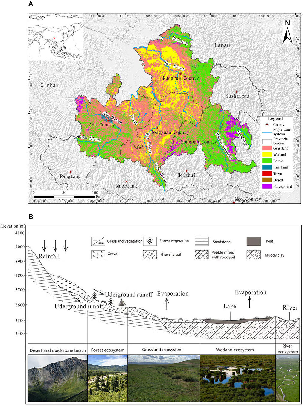
The Ruoergai Prairie (102° 08′-103° 39′ E, 32° 56′-34° 19′ N) is subordinate to Sichuan Province and is located on the northeast edge of the Qinghai-Tibet Plateau. The southeastern Ruoergai Prairie is close to Jiuzhaigou, Songpan, Hongyuan, and Aba counties. The eastern and northern parts are adjacent to the Diebu, Zhuoni, Luqu, and Maqu counties of Gansu Province. The study area, with its complex terrain, can be divided into two geographical units by the watersheds of the Yellow and Yangtze rivers. The mountainous area, with steep terrain and an altitude range of 2,410–4,490 m, is situated to the east. The plateau, which accounts for more than 69% of the county's area, developed on the western side.
The study area, with an average elevation of 3,500 m, is influenced by the humid monsoon climate in the cold temperate zone, and the average annual temperature is 0.6–1.1°C. The vegetation growing season in Ruoergai County is from May to July annually, and rainfall is concentrated during this period. The annual rainfall is 500–600 mm, the annual relative humidity is 69%, and the annual evaporation is 1,232 mm. Ruoergai County is rich in water. The main rivers are the Bailong, Baozuo, and Brazil rivers and Gaqu, Moqu, and Requ rivers, which flow into the Yellow River from south to north. Human disturbance activities in the Ruoergai area include overgrazing, excavations, and mining.
The ecosystem of the study area is mainly composed of grassland, wetland, forest, farmland, urban, desert, and bare land (Figure 1).
2.1. Grassland ecosystem
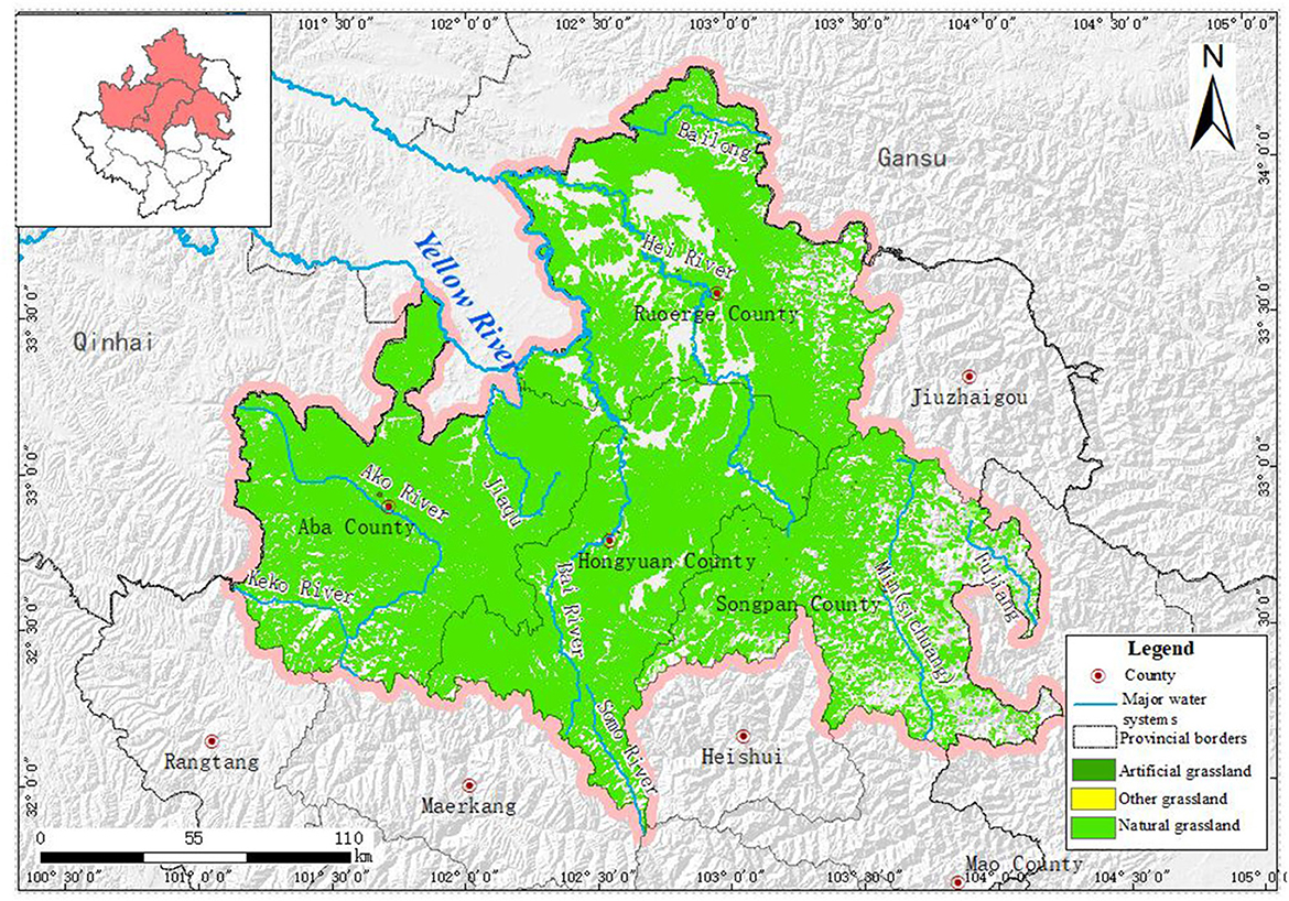
Ruoergai Prairie is the second-largest prairie in China and is classified as the Qinghai-Tibetan Steppe Region. With a total area of 18,227.14 km2, the grassland ecosystem is the major ecosystem type in the study area (Figure 2) and is widely distributed in Ruoergai, Abay, and Hongyuan counties. The grassland in the study area, one of the four major pastoral areas in China, is divided into seven types: alpine meadow, subalpine meadow, alpine marsh meadow, alpine marsh grassland, subalpine forest edge meadow, alpine shrub grassland, and mountain shrub grassland.
2.2. Wetland ecosystem
The Ruoergai wetland is essential to maintaining the Himalayan fauna, flora, and biodiversity. The wetland in the study area covers an area of 6,153.21 km2. It is mainly distributed to the west of Ruoergai, the north of Hongyuan County, the northeast of Aba County, upstream of the Heihe, Baiher, Jiaqu, and Dadu rivers, as well as coastal regions (Figure 3). Over the past 30 years, the Ruoergai alpine peat swamp wetland has degraded into a desert in the northwest (Ruoergai County) and a meadow in the southeast (Hongyuan, Aba, and Songpan counties) (Xiong et al., 2011).
2.3. Forest ecosystem
The northeastern, southern, and eastern parts of the study area, mainly covered by forest, belong to the Yangtze River system, where several terrestrial wild fauna and flora protection areas are also important biodiversity aggregation and water source conservation areas upstream of the Yangtze River. In addition, the northwest, west, and middle parts of the Yellow River system are important water source conservation areas in the Ruoergai Prairie wetland. In the study area, the forest ecosystem is mainly composed of arbor forest and brushwood (Figure 4), with an area of 11,068.88 km2 accounting for 29.81%.
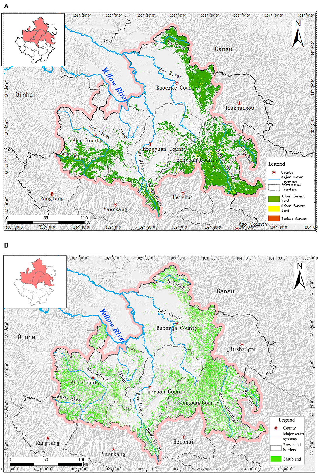
Figure 4. Forest ecosystem distribution in the study area. (A) Arbor forest distribution. (B) Bushwood distribution.
In the study area, arbor forests are mainly distributed in the Minjiang River Basin bordering Songpan County, the Minshan Mountain Range to the east of Ruoergai County, the Keke River Basin to the south of Aba County, and the southwest of Hongyuan County. Bushwood is usually found in the northern part of Songpan County, west of Aba County, the north and east parts of Ruoergai County, and southeast of Hongyuan County. In the Yangtze River Basin, bushwood is mainly distributed in the Bailong, Minjiang, and Dadu river basins. Although it plays a crucial role in maintaining the regional ecological balance, it is also an important water source conservation area upstream of the Yangtze River. The coverage of bushwood is relatively smaller in the Yellow River Basin, only along the edge of the Ruoergai Basin and the middle and upper parts of the hilly plateau area.
2.4. Farmland ecosystem
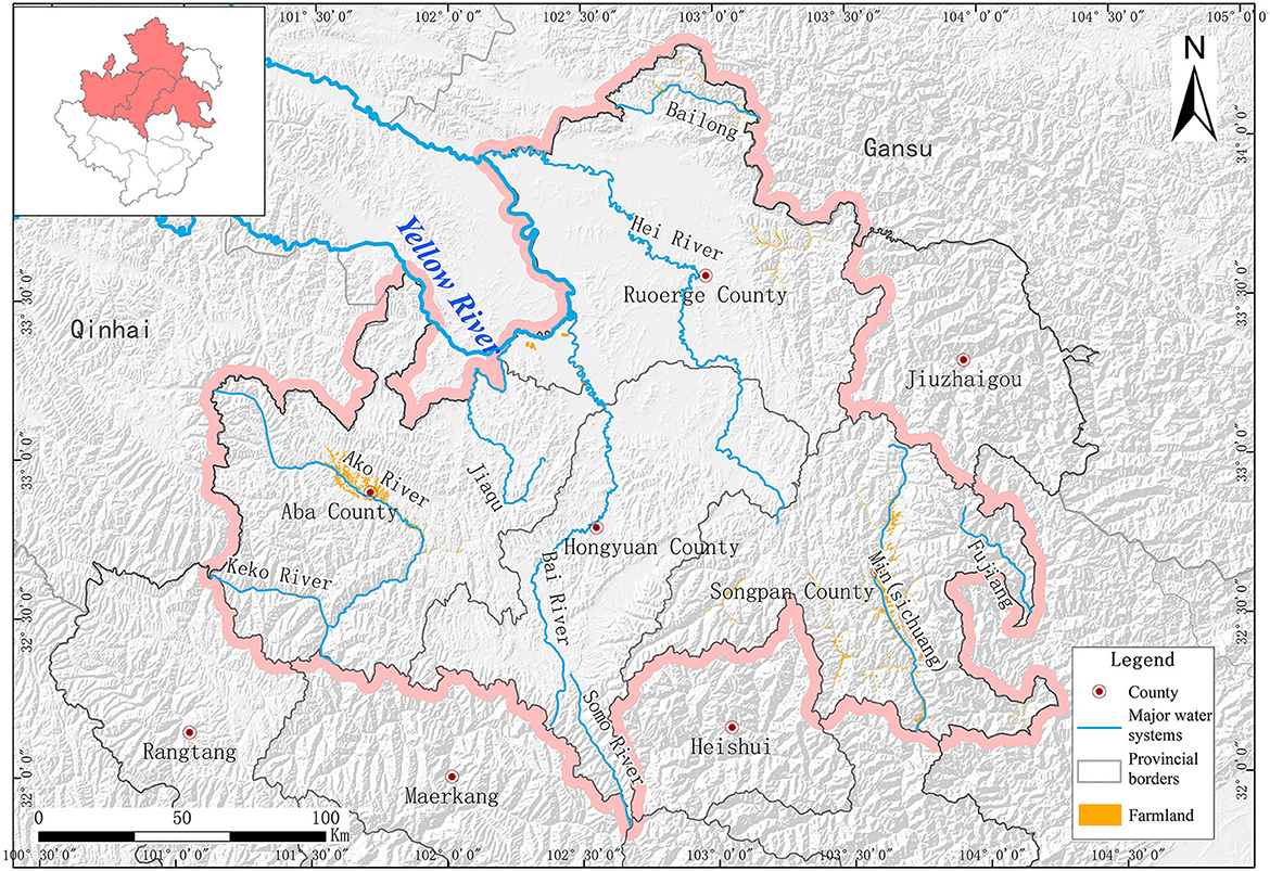
With an aggregate area of 289.53 km2, the farmland ecosystem of the study area is located in Songpan, Aba, and Ruoergai counties (Figure 5). It is mainly composed of cultivated land and garden plots.
2.5. Urban ecosystem
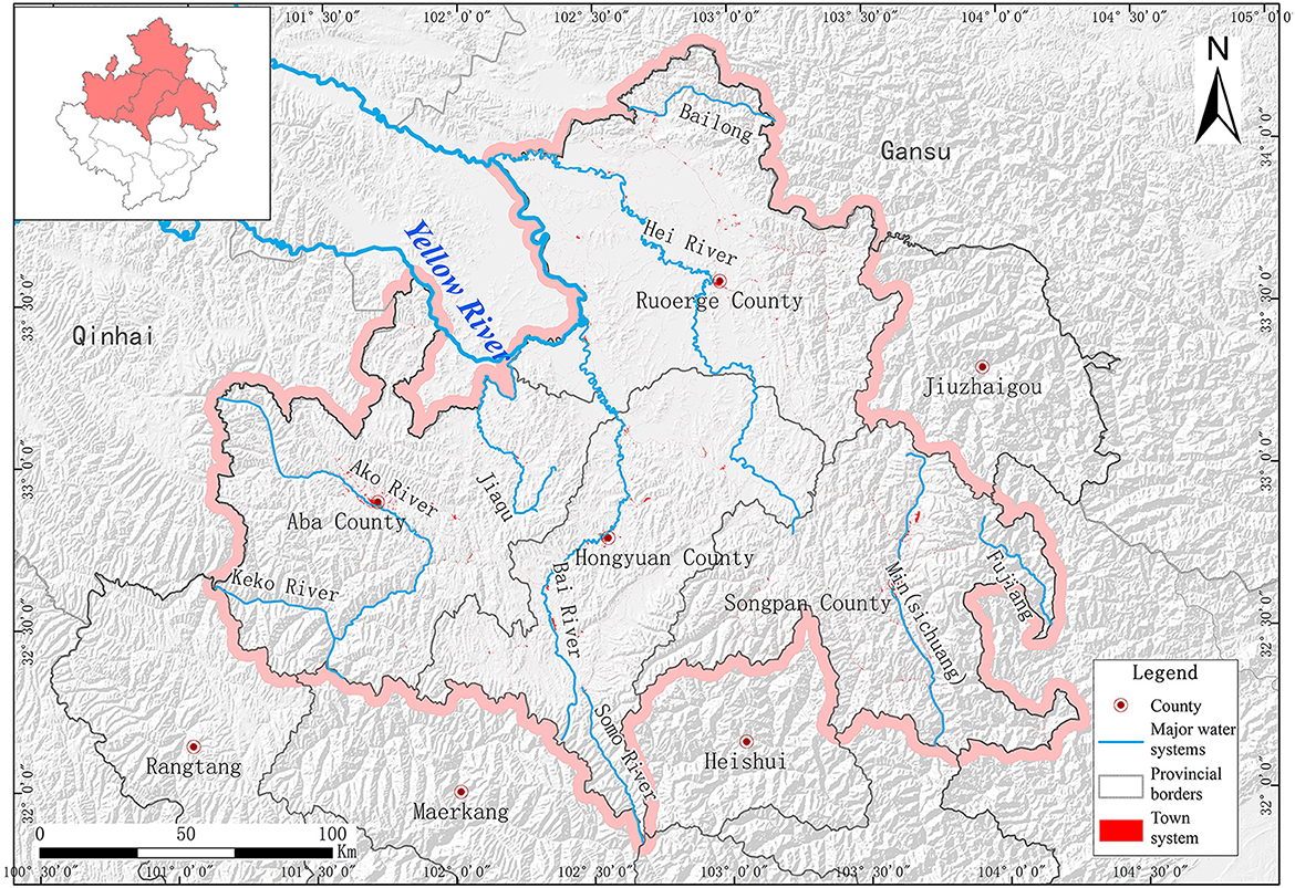
The urban ecosystem, with a total area of 187.31 km2, accounts for 0.50% of the study area and is scattered around counties and within the borders of towns (Figure 6).
2.6. Desert ecosystem
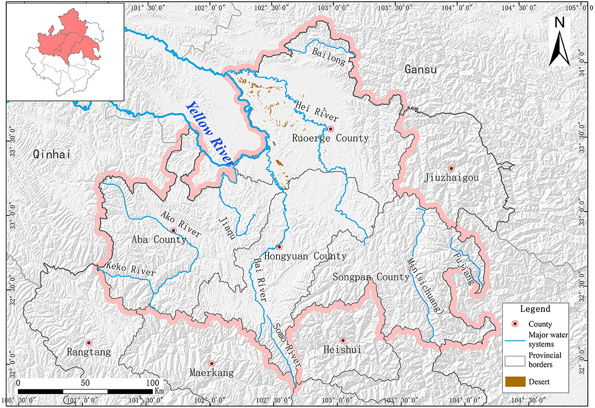
The desert ecosystem covers an area of 49.42 km2, accounting for 0.13% of the study area. Sandy land was mainly distributed in the western region of Ruoergai County (Figure 7). Intra-regional sandy land is largely pasture, mainly caused by land desertification.
2.7. Bare land ecosystem
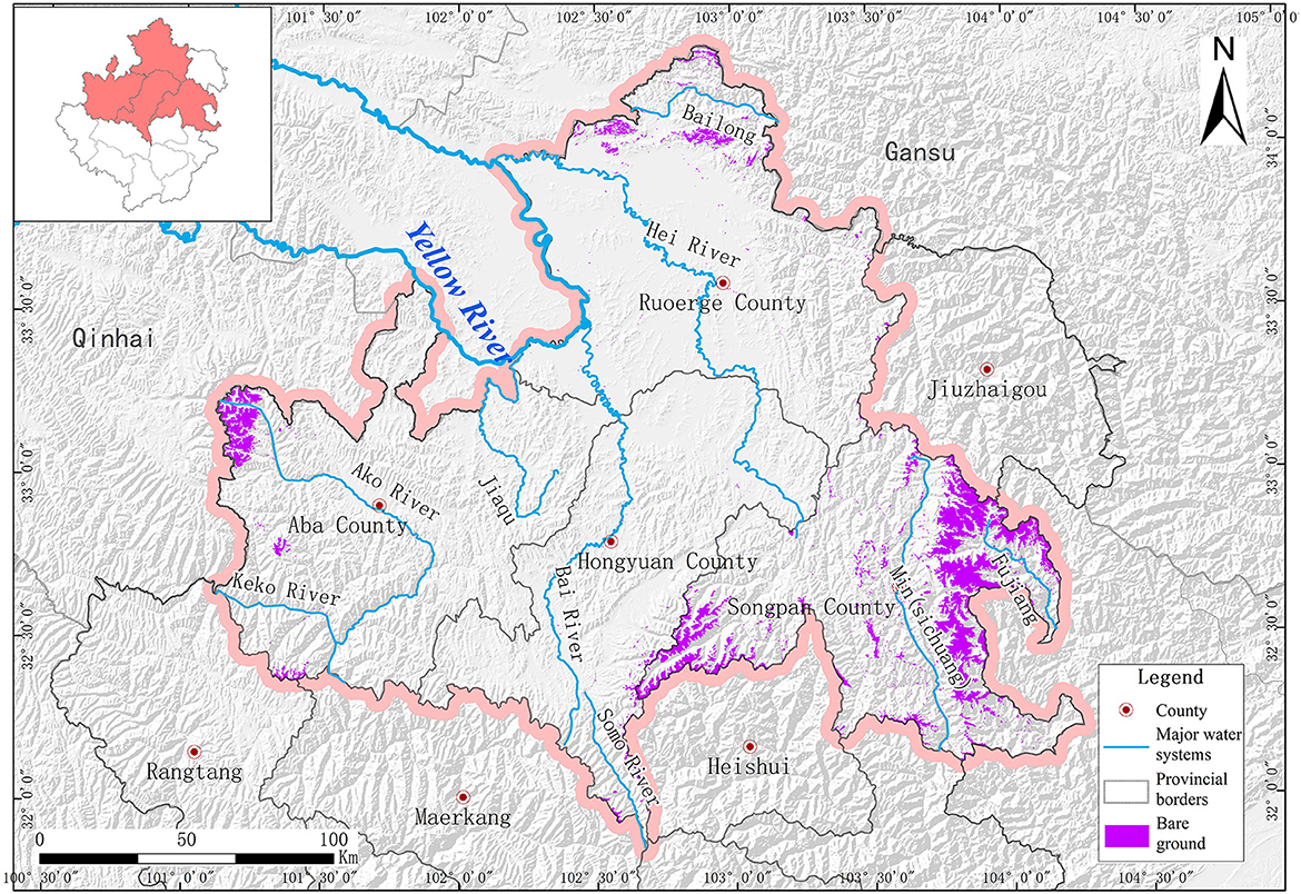
Bare land and rock-gravel land constitute the central part of the bare land ecosystem in the study area (Figure 8). It is mainly distributed on the tops of many huge mountains, such as Yakexia Snow Mountain, the western slope of Zhegushan Snow Mountain, Lianbaoyeze in Aba County, and Xuebaoding-Gonggangling in Songpan County, where glacier, snow, and permafrost usually exist. Besides the gross area of 1,160.19 km2, there are also 0.43 km2 of scattered bare and idle lands. Bare land is indispensable to maintaining the study area's river hydrological ecology.
3. Methods
The administrative regions of the Ruoergai Prairie include Ruoergai, Hongyuan, Aba, and Songpan counties in Sichuan Province, Maqu and Luqu counties in Gansu Province, and Jiuzhi County in Qinghai Province. This study used the Ruoergai Prairie as the research area and ArcGIS software to pre-process digital elevation model (DEM) data with a spatial resolution of 30 m (including Ruoergai, Hongyuan, Aba, Songpan, and other administrative areas), such as splicing and projection. The data projection was unified using UTM/WGS84 to obtain DEM data within the study area.
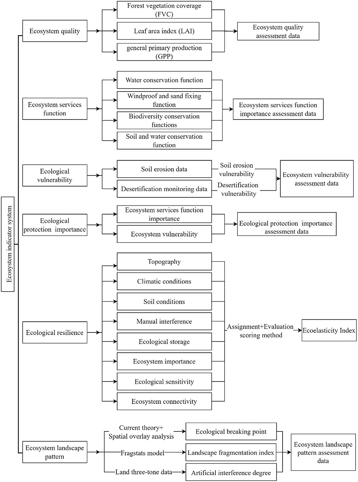
Regarding issues related to the protection and restoration of the main degraded ecosystems, including grasslands, wetlands, and forests, the evaluation methods for ecological system quality, ecosystem service function importance, ecological vulnerability, ecological protection importance, ecological resilience, and ecological landscape pattern were proposed in this study (Figure 9).
3.1. Ecosystem quality evaluation method
Remote sensing ecological index (RSEI) (forest vegetation coverage (FVC), leaf area index (LAI), and general primary production (GPP) were used as indicators to identify the existing quality problems of the ecosystem by evaluating food chain integrity, biodiversity, and structural function stability based on the practical situation of the study area. Considering the maximum values of the ecological indices of the four types of ecosystems, including forest, brushwood, grassland, and farmland, as reference values, the ratios between the ecological indices and reference values of all four ecosystem types individually were used to obtain the relative density of the corresponding ecological index. If the ratio was closer to 1, the ecological index of the ecosystem was closer to the reference value, and the ecosystem quality was better in this area. Then, the ecosystem quality index (EQI) was calculated after the numerical normalization of the data. The ecosystem quality index (EQI) was ranked into different levels according to the Technical Specifications for Ecological Conditions Investigation and Assessment-Ecosystem Quality Assessment to obtain the ecosystem quality level of the study area.
3.2. Importance of ecosystem service function evaluation
The ecosystem service function evaluation mainly includes evaluating the importance of ecological service functions such as water conservation, biodiversity maintenance, grassland and wetland preservation, wind prevention, and sand fixation. The service values of different types of ecosystems were obtained through evaluation. Following the Guides for Ecological Protection Red Line Delineation, the corresponding values of cumulative service value at 50 and 80% of the total ecosystem service value were used as the points for ecosystem service function grading. The importance of ecosystem service functions was divided into three levels. Levels I, II, and III represent “extremely important,” “important,” and “generally important” levels, respectively. Further details are shown in Figure 9.
The relative importance of ecosystem water conservation can be evaluated using water conservation, which is calculated by subtracting evapotranspiration and surface runoff from precipitation. Ecosystem types in arid and semi-arid lands, the number of days in windy weather, vegetation coverage, and soil sand content are the basis for ecosystem wind prevention and sand fixation importance evaluations. Using ecosystem wind prevention and sand fixation serviceability as evaluation indicators and wind prevention and sand fixation amount (the difference between potential and actual wind erosion) as evaluation parameters, it is possible to determine the regional wind prevention and sand fixation amount through the revised wind erosion equation, based on remote sensing statistics, digital elevation, meteorological and soil data, and data from the MODIS snow cover product of China.
Because ecosystems, species, and genetic resources reflect the importance of the biodiversity maintenance function, evaluation of the importance of biodiversity maintenance functions could be performed from these three aspects. The plant net primary productivity (NPP) and meteorological and elevation data were used to obtain the regional biodiversity maintenance indices. Biodiversity maintenance serviceability was used as the evaluation index. Ecosystem authenticity and integrity, species conservation value, and important genetic resources were combined.
The relative importance of ecosystem soil conservation function was evaluated based on ecosystem types, vegetation coverage, and differences in topographic features. Water and soil conservation functions were mainly determined by climate, soil, topography, and vegetation. Considering ecosystem water and soil conservation indicators as evaluation indices and water and soil conservation amount (the difference between potential and actual soil erosion) as the evaluation parameters, we expected to obtain the regional water and soil conservation amount using the revised water and soil loss equation (RUSLE). Water and soil conservation can be divided into three grades: “general,” “important,” and “extremely important.”
3.3. Methods for ecological vulnerability evaluation
Ecological vulnerability, which reflects the possibility of ecological problems in a certain area, is used to demonstrate the possible ecological consequences of human activities (Li et al., 2018). Water and soil loss vulnerability and desertification vulnerability are two major forms of ecological vulnerability, which were used together to obtain the ecological vulnerability of the study area after analysis based on the soil erosion and desertification monitoring data. Ecological vulnerability is categorized into five degrees: general, miner, moderate, heavy, and extreme.
3.4. Methods for ecological protection: importance
The importance of ecological protection is obtained based on a comprehensive evaluation of the importance of ecosystem service function and ecological vulnerability, which is divided into three degrees: “extremely important,” “important,” and “generally important.” Ecosystem services include biodiversity maintenance, water conservation, water and soil preservation, wind prevention, and sand fixation. The more important the ecosystem service functions are, the greater the importance of ecological protection.
3.5. Methods for ecological restoration evaluation
The ecosystem restoration ability was calculated using the limit coefficient method. According to the field investigation and analysis results, evaluation scoring assigned values to relevant indices such as topography, climatic conditions, soil conditions, artificial interference, ecological storage, ecosystem importance, ecological sensitivity, and ecosystem connectivity. All data were normalized to obtain a raster plot of the ecological resilience index for the study area. Thus, ecosystem resilience after interference is shown in quantity or space by the resilience index model.
3.6. Methods for ecological landscape pattern evaluation
Habitat patch (relatively homogeneous non-linear region different from surroundings) islanding refers to the ecological environment showing a discontinuity for a breach of integrity. It becomes very different from the surrounding environment (Zhang et al., 2021). This phenomenon would greatly weaken the operation and control efforts of the ecosystem and cause problems with biogenic migration, which could directly affect regional ecosystem functions and threaten the sustainable development of the regional ecosystem. Based on current theory and spatial overlaying, namely the uniform spatial reference system, this study aimed to identify the ecological source, ecological corridors, ecological pinch points, barriers, and existing corridors (including river and road corridors) in the study area and constitute the ecological safety pattern of Ruoergai, Hongyuan, Aba, and Songpan counties by performing set pre-computations for a series of data. The landscape surface was regarded as a conductive surface. Considering the advantage of the random flow property of electrons in the circuit, it can be used to predict the spreading and migration rules of species, identify more alternative paths in a certain width of the landscape, and confirm the relative importance of habitat patches and corridors based on the inter-source current strength by simulating the migration and spread of individual species or genes in the landscape with electrons on a conductive surface (McRae, 2006; McRae and Beier, 2007; McRae et al., 2008).
The growth of population pressure, cultivated land reclamation, urban construction, and many other human activities have sped up landscape fragmentation in the study area, which directly affects ecological features and processes, including biodiversity, energy flow, and mass circulation in the landscape. Therefore, landscape fragmentation was regarded as the leading cause of wetland ecosystem degradation, weakening, and even loss of biodiversity maintenance. Based on the ecosystem-type data, the Fragstats model was used to simulate the landscape fragmentation indices in the study area. The fragmentation was divided into four degrees: high, relatively high, medium, and low.
A land-cover classification-based human interference grading system was established in accordance with the data of the third national land survey in China. Then, a human activity interference diagram was drawn using the area weight-based comprehensive human interference index model. A quantitative analysis and evaluation of the degree of human interference with land cover in the study area and its dynamic changes from the aspects of boundaries, grids, and the main functional area scale were conducted. The describing factors mainly included frequency (the number of interferences within a certain time), strength (the degree of influence of interference on pattern and process or ecosystem structure and functions), area (the area of landscape suffering from interference within a certain time after interference), and influence (the influence of interference on organisms, communities, or ecosystems).
4. Results
4.1. Ecosystem quality
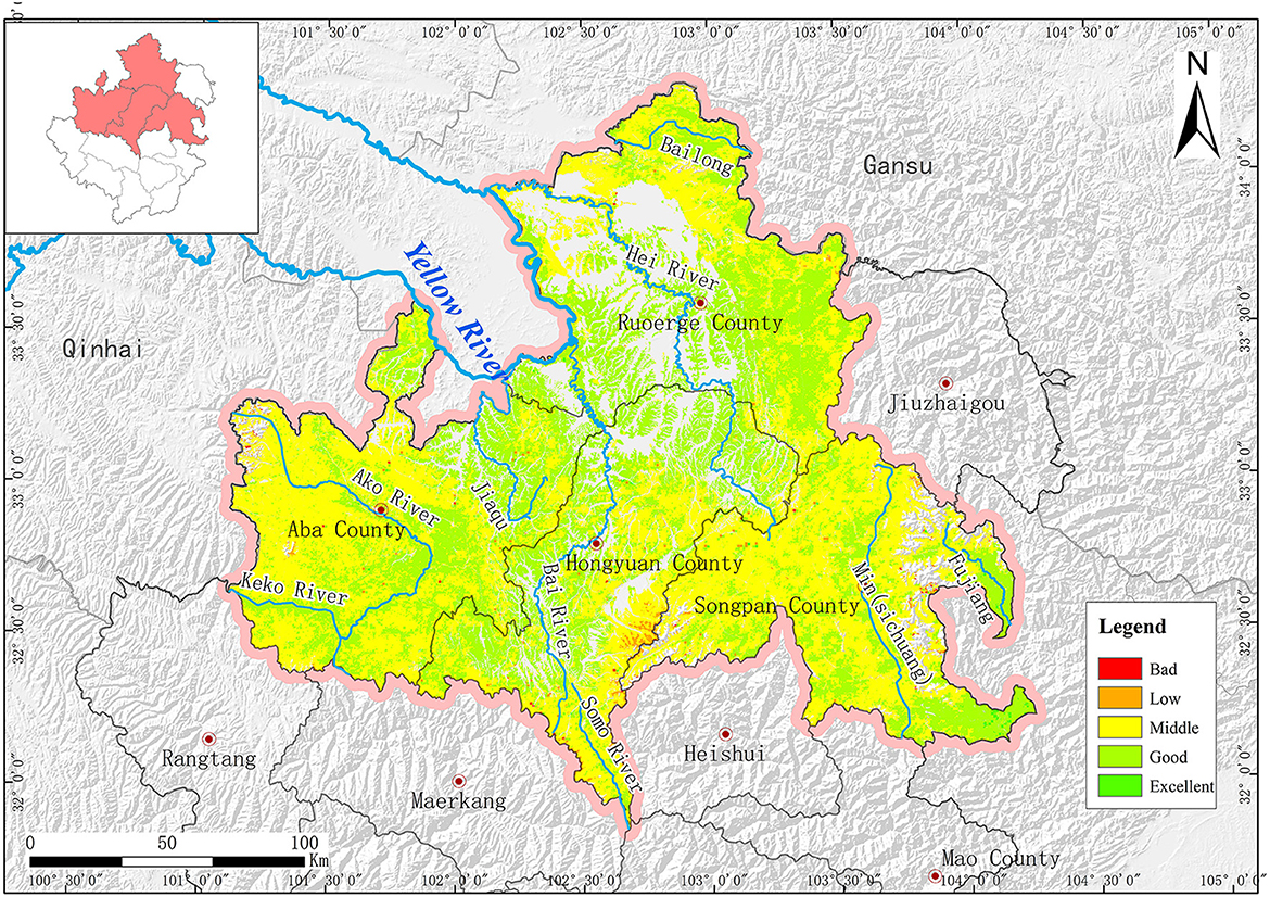
The high ecosystem quality area, with an area of 48.71 km2 (Figure 10), is mainly scattered around the upstream source areas of the Baihe, Heihe, and Dadu rivers, as well as the Giant Panda National Park (Songpan Area). In contrast, areas of relatively low and poor ecosystem quality are distributed in the Baihe, Heihe, Minjiang, and Dadu river basins at scattered points, with an area of 291.72 and 17.52 km2, respectively. The medium ecosystem quality area accounts for 56.78%, and the good ecosystem quality area accounts for 42.01% of the study area are widely distributed in forests, brushwood, cultivated land, and grass fields.
4.2. Importance of ecosystem service function
The amount of water conserved was calculated using the water balance equation. The importance of the water conservation function was evaluated according to the ecosystem type, meteorological, and evapotranspiration data. The existing and expected areas for implementing the water conservation function were identified (Figure 11).
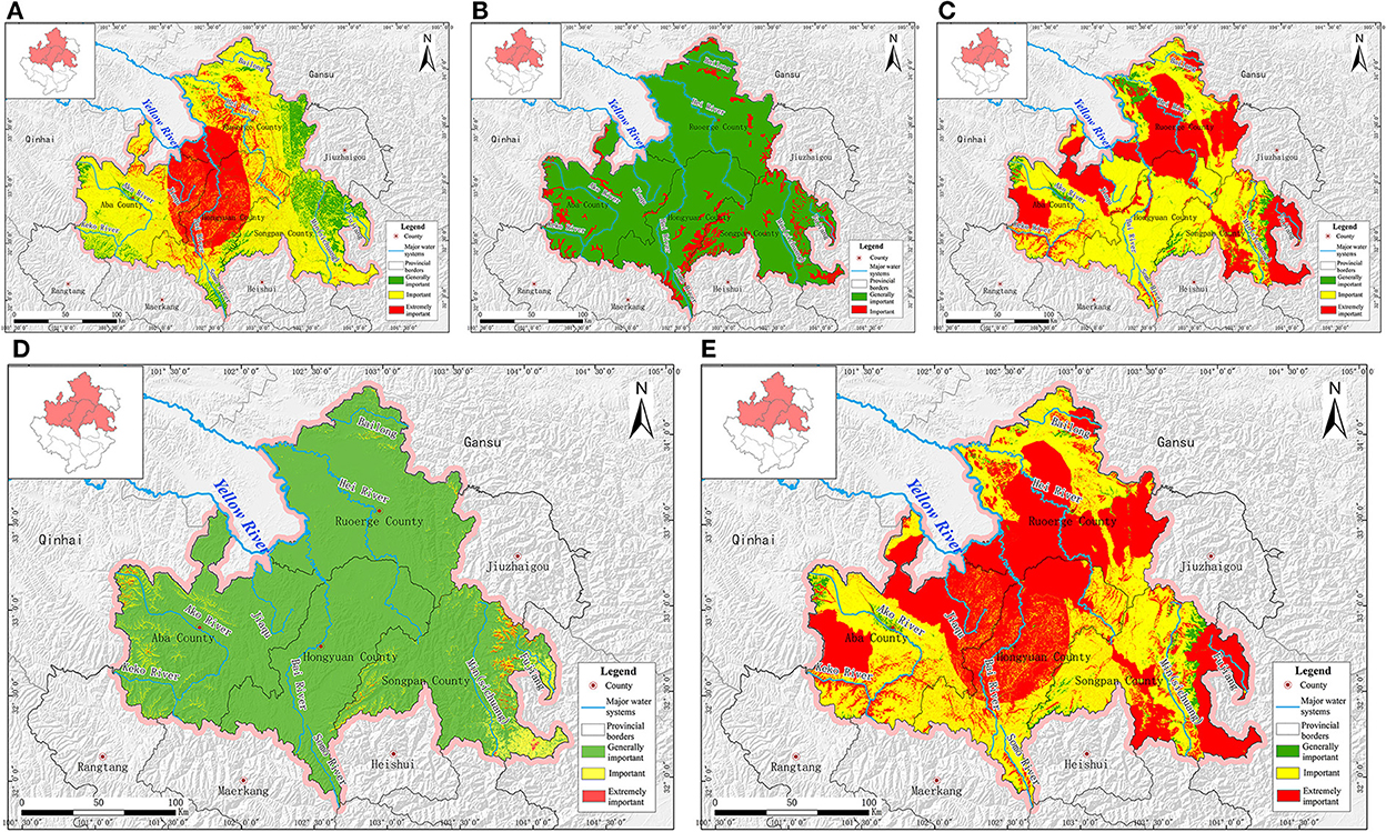
Figure 11. Importance assessment. (A) Water conservation function. (B) Windbreak and sand fixation function. (C) Biodiversity maintenance function. (D) Water and soil conservation function. (E) Ecosystem service function.
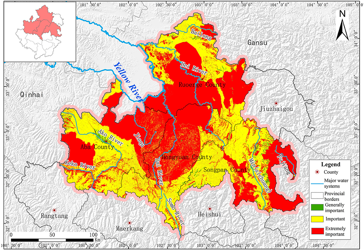
The entire study area can be divided into three parts: the “generally important,” “important,” and “extremely important” parts, accounting for 13.48, 63.09, and 23.43%, respectively. The generally important part was composed mainly of residential land, and mountains are distributed in Songpan County and east of Ruoergai County. The important part was mainly distributed in Aba County, the middle of Ruoergai County, and the west of Songpan County. The extremely important part dominated by the wetland ecosystem was clustered at the junction of the four counties: Aba, Hongyuan, Songpan, and Ruoergai.
The wind prevention and sand fixation results are shown in Figure 11B. They can be graded as a “generally important degree” or an “important degree.” The general important degree area accounted for 90.09%, and the important degree area accounted for only 9.91% and was mainly distributed in Ruoergai County.
The results of the calculation of the biodiversity maintenance ability index for the study area are shown in Figure 11C. Of the study area, 37.53% plays an essential role in biodiversity maintenance and is mainly composed of the Ruoergai wetland, Giant Panda National Park (Songpan), Tiebu, Baozuo, Lianbaoyeze Natural Protection Area, and Sichuan Rewugou Forest Park. Of these, 57.41% were important areas, with the majority distributed in Hongyuan County. The remaining small part of only 5.06% of the study area was generally important for biodiversity maintenance and was mainly covered by residential and bare land.
The results of the important evaluation of the water and soil conservation functions are shown in Figure 11D. The most important area is 97.70%. An important degree area of 2.27% was mainly distributed around and on both sides of the rivers in the study area. The extremely important area, accounting for only 0.03%, was scattered at the source of the Ake River and the eastern part of the Minjiang River.
Based on the analysis of the four major ecological service functions (Figure 11E), the generally important area accounted for 2.10% with an area of 780.31 km2 was mainly covered by a residential area, an important area of 17,108.69 km2 accounting for 46.07% was mainly distributed in the south of Hongyuan County, east of Aba County and west of Songpan County, and the extremely important area of 19,247.10 km2 accounted for 51.83% was distributed in Ruoergai wetland, Baihe River Basin, Giant Panda National Park (Songpan), Tiebu, Baozuo, and Lianbaoyeze Nature Protection Area and Sichuan Rewugou Forest Park.
4.3. Ecological vulnerability
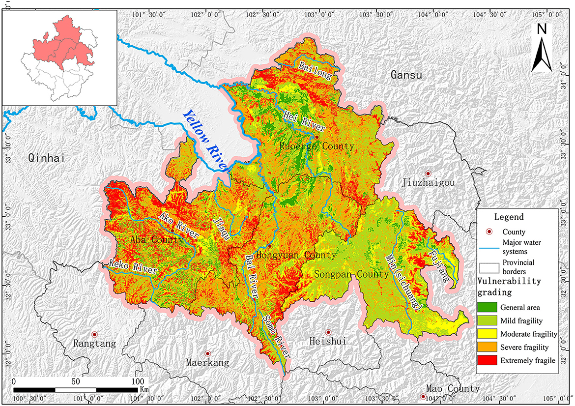
According to the study area ecological vulnerability evaluation results in Figure 12, 6.36% of the study area was generally weak, with an area of 2,361.01 km2, 29.23% was slightly weak, covering 10,854.41 km2, and 15.6% was moderately weak, covering 5,794.25 km2. The heavy weak mainly distributed in Keke River, Baihe River, and Minjiang River Basin with an area of 30.79%. The extremely weak (18.02%) is mainly distributed in the south of Hongyuan County and north of Aba County with an area of 6,693.12 km2, significantly overlapping with the land desertification, water, and soil loss area.
4.4. Ecological protection importance
The ecological protection evaluation results for the study area are shown in Figure 13. The extremely important area for ecological protection in the study area is 19,246.85 km2, which accounts for 51.83%, and is mainly distributed in Ruoergai wetland, Baihe Basin, Giant Panda National Park (Songpan), Baozuo, Lianbaoyeze Nature Protection Area, Sichuan Rewugou Forest Park, the lower section of Keke, and Suomo river basins. Furthermore, the important area for ecological protection is 17,354.54 km2, which accounts for 46.73% of the total and is mainly distributed in the Dadu, Bailong, and Minjiang river basins. The generally important area for ecological protection is only 534.71 km2, accounting for 1.44% of the total area, and is mainly distributed in the Gougu Urban Area.
4.5. Ecological resilience
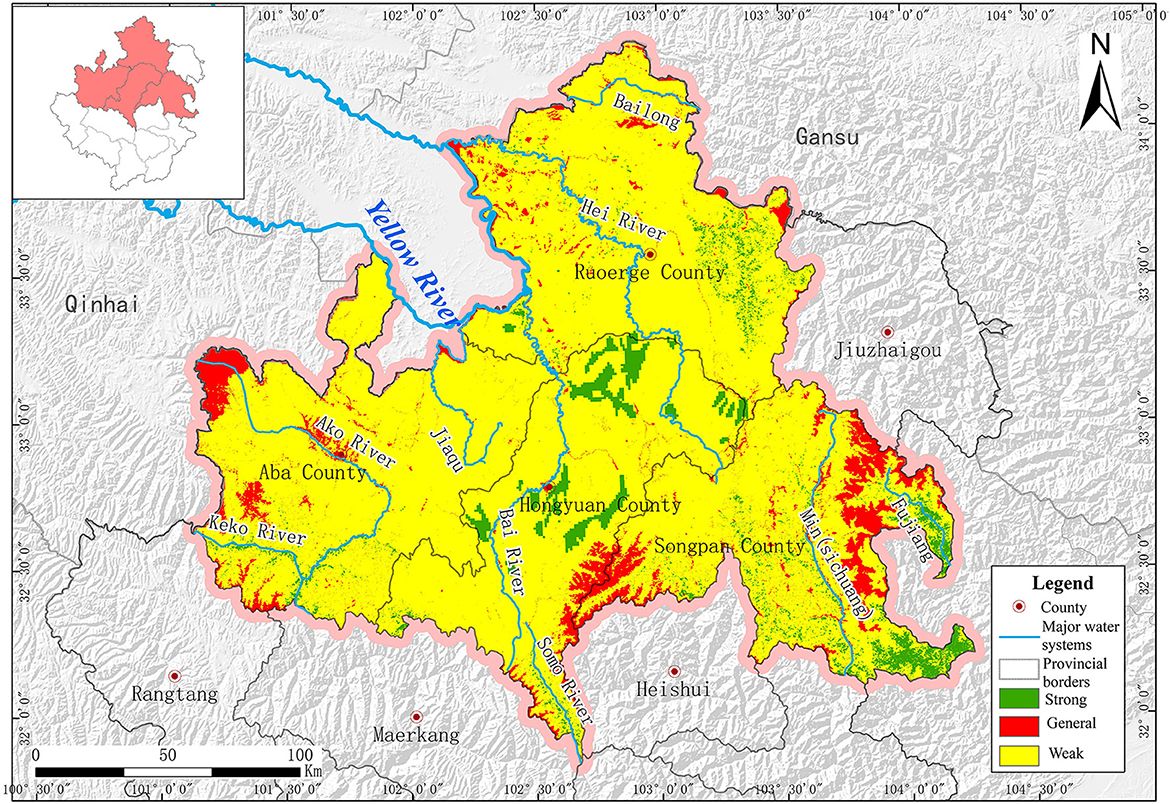
According to the ecological resilience evaluation results (Figure 14), 7.70% of the study area has weak ecological resilience and is mainly distributed in the west and south of Aba County, the south of Hongyuan County, the Ruoergai wetland, the Bailong River Basin, the Minjiang River Basin, and the Middle East of Songpan County. Ecological resilience (87.64%) was widely distributed in the study area. Only 4.66% was strong in ecological resilience, mainly distributed in Ruoergai, Songpan, and Hongyuan counties.
The ecological environment in the study area is difficult to restore after damage, mainly because the study area stretches across the alpine valley region of Hengduan County and the alpine area of the Qinghai-Tibet Plateau, where the ecological environment is relatively weak with low biological protection potential. Moreover, areas with fragile ecological environments in the study area, such as the Lianbaoyeze rocky mountain area in Aba County, the desertification area in Ruoergai wetland, and high mountainous areas with vegetation in the Minjiang and Bailong river basins, show low ecosystem resilience potential.
5. Discussion
A comprehensive evaluation of the Ruoergai Prairie ecosystem was conducted in this study. Landscape ecosystem problems include increasingly severe landscape fragmentation, human activity interference, overall ecological environment quality, and coercion on land resources. Three ecological breaking points exist in the study area, located in the giant panda migrating corridor in the Peijiang River Basin, the wildlife migrating corridor in the Ake River Basin, and the wildlife migrating corridor in the Lianbaoyeze Nature Protection Area (Figure 15A). The cause of the Ake River's breaking point area can be attributed to ecosystem degradation, ecological and environmental damage, roads, water systems, and other linear engineering constructions in valleys that have hindered wildlife migration between ecological sources on both sides of the valley. The Lianbaoyeze breaking point area is caused by geological disasters, including debris flows, landslides, and collapses, which have destroyed wildlife migrating corridors in the Lianbaoyeze Nature Protection Area. The breaking of the giant panda migration corridor upstream of the Peijiang River Basin threatens biodiversity. Although the study area has developed with a wide range of nature protection areas, high vegetation coverage, and a large number of natural ecological corridors, the expansion of urban and rural construction and the development of modern transportation networks exacerbate ecological patch fragmentation, obstruct ecological space communication, considerably reduce the effective connection between ecological patches, break ecosystem stability, and seriously affect the communication of rare animals such as giant pandas.
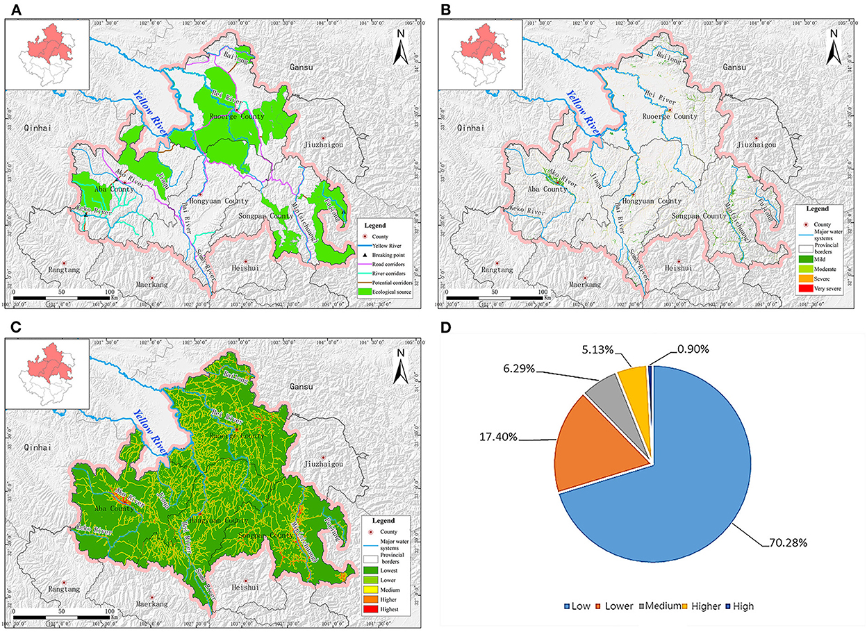
Figure 15. Ecological and environmental problems. (A) Ecological corridors. (B) Landscape fragmentation. (C) Human activity interference degree diagram. (D) Statistic of human activity interference degree.
Based on the ecosystem type data, the landscape fragmentation indices of the study area were graded into four levels (Figure 15B) by the Fragstats simulation. Areas of high and relatively high fragmentation were distributed in Ruoergai and Hongyuan counties. Moderate fragmentation areas are scattered in Aba, Hongyuan, and Ruoergai counties. The area of relatively low fragmentation mainly covers Aba and Ruoergai counties, and the area of low fragmentation covers the entire study area extensively.
A ground-based artificial interference evaluation model was established according to the third national land survey data to obtain the degree of human activity interference diagram (Figure 15C). Under the effects of large-scale human construction activities, the prominent ecological problems caused by human activities include river basin ecosystem damage due to extensive agricultural and forestry utilization, the negative influence of cascade river development on the river basin ecological environment, river basin ecological environment degradation caused by disordered industrial construction, and the occupation of fertile land and wetlands caused by unreasonable use of urban land. This has seriously impeded the local river basin region's overall social and economic development.
Figure 15D shows the human interference statistics. The degree of human interference is densely distributed within the scope of the study area. Relatively high human interference areas are mainly distributed in construction land-centered areas, including urban and road areas. Urban areas suffer the greatest amount of human interference. High mountainous areas to the south of the study area show relatively low human interference and density.
Because the ecosystem of the study area is diverse and complex, and ecological environment change is a long-term process, studies on ecosystem changes and assessment need to be considered from multiple disciplines. In this study, the Ruoergai Prairie was considered a case study, and a comprehensive assessment of multiple ecosystems was conducted. The data obtained in this study can be used as a reference for local ecological restoration. This study has some limitations. Although many influencing factors are involved in the ecosystem, only important indicators were selected for this study. In addition, some environmental factors were not independent. The elimination of the correlation between elements is also worth considering. Some assessments have still not been considered, such as those on ecosystem risk, ecosystem sensitivity, and ecological health.
6. Conclusion
According to the comprehensive analysis, evaluation, and statistical results on ecosystem quality, ecosystem service function importance, ecological vulnerability, ecological protection importance, and ecological resilience, 98.79% of the study area was identified and evaluated at fine and good levels in ecosystem quality, 97.90% at important and extremely important levels in ecosystem services, 64.41% with a weak ecological environment, 98.56% at important and extremely important levels in ecological protection, and 87.64% with neither good nor bad ecological resilience. The ecological landscape in the study area has difficulties in breaking points, a high fragmentation degree, and severe coercion on land resources, which require integrated protection and restoration over mountains, waters, forests, farmlands, lakes, grasslands, sand, and glaciers.
Data availability statement
The original contributions presented in the study are included in the article/supplementary material, further inquiries can be directed to the corresponding author.
Author contributions
XX: funding acquisition, supervision, and project administration. QY: conceptualization and writing-original draft. GX: writing-review and editing. TL and XX: data curation. MY and TJ: formal analysis and investigation. All authors contributed to the article and approved the submitted version.
Funding
This study was supported by the Natural Science Foundation of Sichuan Province (Grant Nos. 2022NSFSC1053 and 2022NSFSC1121).
Conflict of interest
The authors declare that the research was conducted in the absence of any commercial or financial relationships that could be construed as a potential conflict of interest.
Publisher's note
All claims expressed in this article are solely those of the authors and do not necessarily represent those of their affiliated organizations, or those of the publisher, the editors and the reviewers. Any product that may be evaluated in this article, or claim that may be made by its manufacturer, is not guaranteed or endorsed by the publisher.
References
Bai, J. H., Ouyang, H., and Cui, B. S. (2008). Landscape pattern change of Zoige plateau alpine wetland during the past 40 years. Acta Ecol. Sin. 28, 2245–2252. doi: 10.1016/S1872-2032(08)60046-3
Bai, J. P. (2013). Study on Ecological Restoration Process and Ecosystem Service Function in Zoige Alpine Grassland Desertification Control Area. Yaan: Sichuan Agricultural University.
Committee on the National Ecological Observatory Network. NEON-Addressing the Nation's Environmental Challenges. Washington DC: The National Academy Press. (2004).
Cui, S. H., Wu, H., Pei, X. J., Yang, Q. W., Huang, R. Q., and Guo, B. (2022). Characterizing the spatial distribution, frequency, geomorphological and geological controls on landslides triggered by the 1933 Mw 7.3 Diexi Earthquake, Sichuan, China. Geomorphology 403, 108177. doi: 10.1016/j.geomorph.2022.108177
De Lange, H. J., Sala, S., Vighi, M., and Faber, J. H. (2010). Ecological vulnerability in risk assessment: a review and perspectives. Sci. Total Environ. 408, 3871–3879. doi: 10.1016/j.scitotenv.2009.11.009
Hou, M., Ge, J., Gao, J., Meng, B., Li, Y., Yin, J., et al. (2020). Ecological risk assessment and impact factor analysis of alpine wetland ecosystem based on LUCC and boosted regression tree on the Zoige Plateau, China. Remote Sens. 12, 368. doi: 10.3390/rs12030368
Hu, G. Y., Dong, Z., Lu, J., and Yan, C. (2012). Driving forces of land use and land cover change (LUCC) in the Zoige Wetland, Qinghai-Tibetan Plateau. Sci. Cold Arid Reg. 4, 422–430. doi: 10.3724/SP.J.1226.2012.00422
Hu, S. J. (2019). Evaluation of the Ecological Conservation Effect. Yaan: Sichuan Agricultural University.
Huang, P. Y. (1989). Preliminary evaluation on the development of Mosuo Bay and the influence on desert ecosystem. Arid Land Geogr. 2, 1–7.
Jiang, W., Lv, J., Wang, C., Chen, Z., and Liu, Y. (2017). Marsh wetland degradation risk assessment and change analysis: a case study in the Zoige Plateau, China. Ecol. Indicat. 82, 316–326. doi: 10.1016/j.ecolind.2017.06.059
Li, G. M., Guo, B., Gan, Q., and Li, S. (2018). Remote sensing monitoring and evaluation of ecosystem vulnerability in Ruoergai County. Surv. Map. Geogr. Inform. 43, 11–14. doi: 10.14188/j.2095-6045.2016166
Li, J., Wang, W., Hu, G., and Wei, Z. (2010). Changes in ecosystem service values in Zoige Plateau, China. Agric. Ecosyst. Environ. 139, 766–770. doi: 10.1016/j.agee.2010.10.019
McRae, B. H. (2006). Isolation by resistance. Evolution 60, 1551–1561. doi: 10.1111/j.0014-3820.2006.tb00500.x
McRae, B. H., and Beier, P. (2007). Circuit theory predicts gene flow in plant and animal populations. Proc. Natl. Acad. Sci. U. S. A. 104, 19885–19890. doi: 10.1073/pnas.0706568104
McRae, B. H., Dickson, B. G., Keitt, T. H., and Shah, V. B. (2008). Using circuit theory to model connectivity in ecology, evolution, and conservation. Ecology 89, 2712–2724. doi: 10.1890/07-1861.1
O'Malley, R. (2008). The State of the Nation's ecosystems 2008: measuring the lands, waters, and living resources of the United States. Fut. Surv. 28, 215–224.
Pang, A., Li, C., Wang, X., and Hu, J. (2010). Land use/cover change in response to driving forces of Zoige County, China. Proc. Environ. Sci. 2, 1074–1082. doi: 10.1016/j.proenv.2010.10.119
Pang, Y. J. (2019). Evaluation and Monitoring of the Zoige Plateau Wetland Ecosystem Based on Remote Sensing Technology. Wuhan: Wuhan University.
Peng, H., Zhai, J., Jin, D. D., Zhou, Y., Chen, Y., and Gao, H. F. (2022). Assessment of changes in key ecosystem factors and water conservation with remote sensing in the Zoige. Diversity 14, 552. doi: 10.3390/d14070552
Shao, Q. Q., Fan, J. W., Liu, J. Y., Huang, L., Cao, W., Xu, X., et al. (2016). Evaluation on ecological effects of sanjiangyuan ecological protection and construction phase I project. Acta Geogr. Sin. 71, 3–20. doi: 10.11821/dlxb201601001
Shen, G., Xu, B., Jin, Y. X., Yang, X., and Zhou, Q. (2016). Research progress of Ruoergai Plateau Wetland. Geogr. Geogr. Inform. Sci. 32, 76–82. doi: 10.3969/j.issn.1672-0504.2016.04.013
Shen, G., Yang, X. C., Jin, Y. X., Xu, B., and Zhou, Q. (2019). Remote sensing and evaluation of the wetland ecological degradation process of the Zoige Plateau Wetland in China. Ecolo. Indicat. 104, 48–58. doi: 10.1016/j.ecolind.2019.04.063
Wan, P., Wang, Q. A., Li, Z. Y., Yan, S., Liu, M., Hu, L. X., et al. (2011). Water conservation function of Ruoergay according to soil water storage capacity. Sichuan Environ. 30, 121–123. doi: 10.3969/j.issn.1001-3644.2011.05.026
Wang, Y. Y., He, Y. X., Ju, P. J., Zhu, Q. A., Liu, J. L., and Chen, H. (2019). Application of hierarchical analysis in the study of Joergai wetland degradation. J. Appl. Environ. Biol. 25, 46–52. doi: 10.19675/j.cnki.1006-687x.2018.03042
Wu, C., Chen, W., Cao, C., Tian, R., Liu, D., and Bao, D. (2018). Diagnosis of wetland ecosystem health in the Zoige Wetland, Sichuan of China. Wetlands 38, 469–484. doi: 10.1007/s13157-018-0992-y
Xiong, Y. Q., Wu, P. F., and Zhang, H. Z. (2011). Soil water conservation function during the degradation of Ruoergai Wetland. J. Ecol. 31, 5780–5788.
Zhang, Q. S., Li, F. X., and Wang, D. W. (2021). Research on the change of ecological spatial connectivity in Jiangsu Province based on ecological network. J. Ecol. 41, 3007–3020. doi: 10.5846/stxb202005181264
Keywords: Ruoergai Prairie, grassland degradation, water and soil erosion, ecosystem evaluation, reduction in forest area
Citation: Xu X, Yang Q, Xiang G, Liu T, Yang M, Xiong X and Jiang T (2023) Comprehensive evaluation of the Ruoergai Prairie ecosystem upstream of the Yellow River. Front. Ecol. Evol. 10:1047896. doi: 10.3389/fevo.2022.1047896
Received: 19 September 2022; Accepted: 21 November 2022;
Published: 09 January 2023.
Edited by:
Yunhui Zhang, Southwest Jiaotong University, ChinaReviewed by:
Yao Jiang, Institute of Mountain Hazards and Environment (CAS), ChinaSiyuan Zhao, Sichuan University, China
Copyright © 2023 Xu, Yang, Xiang, Liu, Yang, Xiong and Jiang. This is an open-access article distributed under the terms of the Creative Commons Attribution License (CC BY). The use, distribution or reproduction in other forums is permitted, provided the original author(s) and the copyright owner(s) are credited and that the original publication in this journal is cited, in accordance with accepted academic practice. No use, distribution or reproduction is permitted which does not comply with these terms.
*Correspondence: Qingwen Yang,  eWFuZ3Fpbmd3ZW4xOTkxQG91dGxvb2suY29t; Guoping Xiang,
  eGlhbmdndW9waW5nMTk4OUAxNjMuY29t
 Xiangning Xu1
 Qingwen Yang
 Tao Jiang