 Sen Wang
 Junmo Lu
- School of Architecture, Tianjin University, Tianjin, China
Introduction: The shallow mountainous area in Hebei province is a crucial part of the ecological security barrier and regional ecological conservation construction in the Beijing-Tianjin-Hebei (BTH) region. In recent years, the contradictions in the development of the rural “production-living-ecological” function (PLEF) in shallow mountainous areas are prominent, so optimize its spatial pattern is beneficial to rural sustainable development. But there are significant problems in the existing research, such as the lack of fine-scale research and effective guidance for rural PLEF. Based on this, this study takes Quyang County as an example, starts from the perspective of PLEF coordinated development, finally puts forward the optimization strategy of rural production-living-ecological space (PLES) pattern by evaluating rural PLEF and its coupling co-scheduling.
Methods: This study first fused multi-source data such as POI and remote sensing images to build a comprehensive evaluation system of rural PLES, combined with entropy weight method and analytic hierarchy process to give weight to various indicators, and calculated the PLEF distribution of Quyang County on the 300 × 300m grid scale. Then the collaborative development of PLEF is measured by coupling coordination degree model. Finally, according to PLEF and its coupling and coordination, the functional space types are divided according to the principles of coordinated development and ecological optimization, and the optimization strategy of PLES pattern is proposed on the village scale.
Results: (1) The spatial distribution of PLEF in Quyang County is significantly different, and the order of functional intensity is: ecological space (ES) > production space (PS) > living space (LS). (2) The PLEF coupling coordination degree generally presents the spatial distribution characteristics of “low in the north and high in the south”, which is highly related to its topographic features. The high-value areas are mainly spread over southern plains with developed economy and rich ecological resources, while the low-value areas are located in the northern mountains and the central hills. (3) On the grid scale, the PLES pattern is identified as six types: production-living-ecological balance space (PLEBS), production-living space (PLS), production-ecological space (PES), living-ecological space (LES), ES and PS. Among them, the proportion of PLEBS and ES is larger. (4) On the village scale, it is suggested that PLEBS villages further emphasize high-quality coordinated development; ecological function leading optimization type (EFLOT) villages adhere to ecological priorities and ensure the development of ecological space functions; villages with composite functions should combine their own advantages and the spatial characteristics of the surrounding countryside, optimize and control infrastructure configuration, industrial structure, ecological protection and other aspects of classification, overcome shortcomings and improve the coordination of the PLEF.
Discussion: Based on previous studies, this paper explored and improved the research scale, analysis methods, evaluation indexes and optimization ideas in the field of rural PLEF. Therefore, the results can guide for the high-quality coordinated development of territorial space and rural revitalization construction of counties in shallow mountainous areas.
1. Introduction
As an important carrier for the existence and development of mankind, territorial space is crucial to the “production-living-ecological” function, including the function of production, living, and ecology (Wu et al., 2021). The natural properties of spatial resources such as scarcity and diversity of uses (Luo and Zeng, 2003; Liu and Zeng, 2009; Jiang and Zeng, 2010) restrict the coordinated development of population, economy, resources, and environment (Chen et al., 2001). In recent years, the spatial structure of production-living-ecological space (PLES) has become disequilibrium with the rapid urbanization, resulting in many problems such as extensive land development (Cao et al., 2012; Xiao and Shen, 2012), environmental pollution (Tan et al., 2011; Xing and Li, 2012), ecological land and construction land competition contradiction (Yuan, 2011; Zhu and Qin, 2012), etc. Therefore, China has proposed the concept of PLES, which requires intensive and efficient production space, livable and moderate living space, and clean and beautiful ecological space. It marks that the development pattern of territorial space has shifted from the production space as the dominant to the coordinated development mode of PLES (Yuan, 2011; Zhu and Qin, 2012). However, the conflicts between the spatial structures of PLES are constantly escalating, which makes the unbalanced and inadequate development of production-living-ecological functions (PLEF) increasingly prominent (Liao et al., 2017).
The shallow mountainous area is the transition zone between mountain and plain, which is frequently disturbed by human activities and has an ecological conservation function. It has been under certain development pressure or is likely to be affected by urbanization in the future (Yu et al., 2009; Xu et al., 2013). As the basic carrier of sustainable development strategy, rural PLES is the place for villagers’ production and living activities. However, excessive human activities and extensive management modes have caused pollution and damage to rural ecological space (ES) in shallow mountainous areas, which has resulted in the dysfunctional of rural PLEF and the disorderly development of space. The contradiction among PLES in shallow mountainous areas is more prominent, leading to a series of problems known as “rural diseases” such as land pollution, poor environmental quality, etc. Optimizing the pattern of PLES is an essential measure for the healthy development of rural areas (Duan et al., 2021; Zeng et al., 2021), which is significant to urban–rural coordination development and the construction of rural revitalization in shallow mountainous areas.
The identification and reconstruction of the spatial pattern of PLEF is an important foundation for the optimization and coordinated development of the territorial spatial pattern (Chen et al., 2021). At present, relatively fruitful results have been achieved in the field of the identification of PLEF and the pattern reconstruction of PLES. The research content mainly focused on the connotation of PLEF (Rudolf, 2005; Huang et al., 2020), the identification of the PLES pattern (Zou et al., 2020; Chen et al., 2021; Duan et al., 2021; Fu et al., 2021; Wu et al., 2021), the evolution of the PLES pattern (Deng and Yang, 2021; Tao et al., 2021; Wei et al., 2021; Zhao et al., 2021), and the optimization of its spatial pattern (Tian et al., 2020; Fu et al., 2021; Yin et al., 2021). Generally speaking, the identification of PLES can be realized by two mainstream methods: Land Use Classification (LUC) (Liu et al., 2017; Li et al., 2021; Lin et al., 2021) and Evaluation Index System (EIS) (Liao et al., 2020; Yang et al., 2020; Zou et al., 2020; Wei et al., 2021). The LUC method mainly determines PLEF by re-classifying (Zhang et al., 2015; Zhou et al., 2020; Li et al., 2021) or functional evaluation (Liu et al., 2017; Yang et al., 2020; Deng and Yang, 2021; Tao et al., 2021; Zhu et al., 2021) of land use types, which has insufficient consideration of functional complexity and spatial base heterogeneity (Ji et al., 2020). The EIS method quantifies PLEF by constructing an evaluation system (Zhang et al., 2020; Wei et al., 2021), which has the advantages of regional pertinence and comprehensive evaluation system, but has defects such as insufficient function quantification (Zhang Y. et al., 2021). Meanwhile, the current research combines the perspectives of villagers’ temporal and spatial behavior (Duan et al., 2021), scenario simulation (Wu et al., 2021), land use conflict (Dong et al., 2021; Lin et al., 2021; Zhang J. et al., 2021), suitability evaluation (Liao et al., 2020; Yu et al., 2020; Lin et al., 2021), etc. Mechanical equilibrium model (Zhang Y. et al., 2021), joint decision-making model (Tao et al., 2021), coupling coordination degree (CCD) model (Chen et al., 2021; Li et al., 2021; Wei et al., 2021), three-dimensional Rubik’s cube evaluation model (Xie et al., 2021), clustering algorithm (Zhang et al., 2020; Yin et al., 2021) and other methods, proposed the optimization of land space classification plan. Compared with other models and methods, the coupled coordination degree model can reflect the degree of coordinated development of PLEF, and provide a more objective basis for judgments for the regional control and coordinated development of territorial space (Yang et al., 2020). In addition, research on rural pattern optimization and zoning based on the perspective of PLES are also increasing (Deng et al., 2018; Liu et al., 2019a,b; Duan et al., 2021; Gao et al., 2021). But most of them were from a single perspective, such as the evaluation of the suitability of settlements (Gao et al., 2021) and the evaluation of villagers’ behavior (Deng et al., 2018; Duan et al., 2021). Research based on multifunctional coupling and coordination of land-use is still insufficient, which leads to not fully understand the coupling and coordination among rural PLEF, and lacks effective guidance for rural sustainable development in the process of urban–rural transition.
In terms of research scales, previous studies have mostly taken the national, watershed (Li et al., 2021; Zhang Y. et al., 2021), urban agglomerations (Wu, 2019; Yang et al., 2020; Zhou et al., 2020; Zeng et al., 2021) and other macro-scales, and the mesoscales are such as cities, counties and districts (Niu et al., 2021; Yin et al., 2021), The micro-scale, such as the central city (Tian et al., 2020; Fu et al., 2021) and other administrative units as the research scale, the village-scale research are less (Liu et al., 2019a,b; Duan et al., 2021). The main reason is that as the evaluation unit shrinks, it becomes more difficult to obtain data, which leads to the lack of in-depth research on PLES at the village scale. Existing rural PLES research mostly uses towns or counties as the evaluation unit (Wang and Tang, 2018; Yang et al., 2020; Niu et al., 2021; Liao et al., 2022), which has limited reference value for village planning, and it is difficult to effectively support village planning and spatial reconstruction (Liu et al., 2019a; Yin et al., 2021). At the same time, administrative units also have large spatial differences, especially in mountainous areas with complex topographical conditions. The spatial information reflected by studies based on the administrative unit scale is not detailed enough. The geographic grid can effectively compensate for this defect on the administrative unit scale (Chen et al., 2021).
The shallow mountainous areas of Hebei Province are located at the junction of the eastern foot of the Taihang Mountains and the western part of the North China Plain. It undertakes the major task of the construction of the Beijing-Tianjin-Hebei (BTH) ecological barrier and is a vital part of the construction of the ecological conservation zone in Hebei Province. Great changes have taken place in regional land use due to the complex terrain and frequent human activities in this area. Once the land use structure is out of balance, it will inevitably threaten the ecological security of mountainous and plain areas (Liu et al., 2020). Located at the eastern foot of Taihang Mountainy, Quyang County is an important part of the water source of Beijing and Tianjin. From the northwest to the southeast in Quyang County, there are low mountains, hills and plains, which are typical shallow mountain areas and counties in Hebei Province. At present, some scholars have carried out on the pattern of rural PLES in the shallow mountainous areas of Hebei Province and even the BTH region (Yang et al., 2020; Duan et al., 2021; Zeng et al., 2021). For example, Zeng used the lifting regression tree model to explore the driving force between the regional endowment of the BTH region and the PLES (Zeng et al., 2021). Yu established the PLES classification system of Pingshan County, Hebei Province, in the shallow mountain area, and analyzed the landscape ecological risks brought by its transformation (Yu et al., 2022). Zhou explored the driving force of the spatial evolution of the Taihang Mountains through geographical detectors (Zhou et al., 2020). However, they have not conducted research from the perspective of village scale or coordinated and sustainable development, which cannot be effectively guided rural revitalization practice in the shallow mountainous area of Hebei shallow mountainous areas.
Given this, the study used villages and fine-grained grids as the basic units, and built an evaluation index system of county-level PLEF, used villages and grids as evaluation units to measure their CCD of PLEF. According to the function value of production-living-ecological and CCD, the spatial pattern characteristics of production-living-ecological were revealed. Finally, based on the principles of coordinated development and ecological priority, the optimization plan and zoning control strategy of the land space pattern are proposed. The purpose of this research is to provide a reference for the rural coordinated development in shallow mountainous areas.
2. Materials and methods
2.1. Overview of the research area
Quyang County (N38°28′ 20″ to 38°57′ 19″, E114°24′ 30″ to 114°53′ 7″) is located southwest of Baoding City, Hebei Province. This region is rich in mountain water resources, leisure agriculture and eco-tourism are developing rapidly, and forest and garden resources are abundant. It is an important food and fruit production base. Influenced by a series of economic development policies, such as BTH collaborative construction, rural revitalization strategy, etc., Quyang County has witnessed a rapid development of modern characteristic agriculture, accelerated mechanized production process, continuous development of rural tourism, and gradual scale of the industrial and manual processing industry. However, because it is located in the hilly and mountainous areas of southwest of Baoding and the ecological environment is fragile, with the increase of rural development and construction, the contradiction between rural development space and ecological effect is not matched. Under the comprehensive influence of natural resources, ecological environment, social and economic development and other factors, there are significant conflicts in the development of PLEF in Quyang County. How to optimize the interaction of rural PLEF and achieve high-quality coordinated development will be the top priority for Quyang’s future construction (Figure 1).
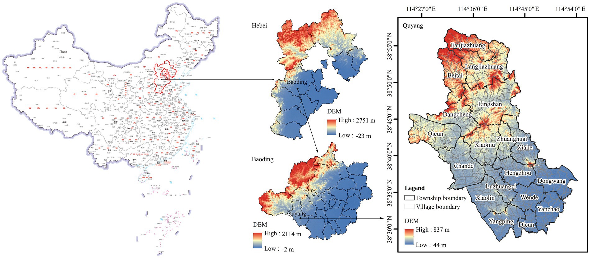
Figure 1. Overview of the study area. This drawing is based on the standard map downloaded from the standard map service website of the Ministry of Natural Resources [drawing review number: GS (2020) 4619], and the base map is not modified.
2.2. Data source and pretreatment
This study takes the development status of Quyang County in 2020 as the research benchmark. The sources and pretreatment methods of the data used in the study are as follows: (1) Land use data in 2020 were obtained from the cloud platform of Data Center for Resources and Environmental Sciences, Chinese Academy of Sciences1, 30 m resolution. According to the actual situation and research needs of Quyang County, the original classification is merged. The specific standards are shown in Table 1. (2) Administrative boundary of villages came from the General Plan of Land Use of Quyang County (2010–2020) and was obtained by GIS vectorization. (3) Village population data came from Sixth Census report of Quyang County. (4) Digital Elevation Model (DEM) in 2020 based on ASTER GDEM V2 data and Landsat 8 OLI_TRIS satellite images derived from geospatial data cloud2, 30 m resolution. (5) 30 m resolution 2020 night light data acquisition in no danger of some data.3 (6) POI data in 2020 such as distribution of agriculture, forestry, animal husbandry and fishery bases, enterprises, medical institutions and schools came from AMap API.4 These POI data were imported into the ArcGIS 10.5, and then the kernel density analysis tool was used to analyze the spatial aggregation of various POIs in Quyang County.
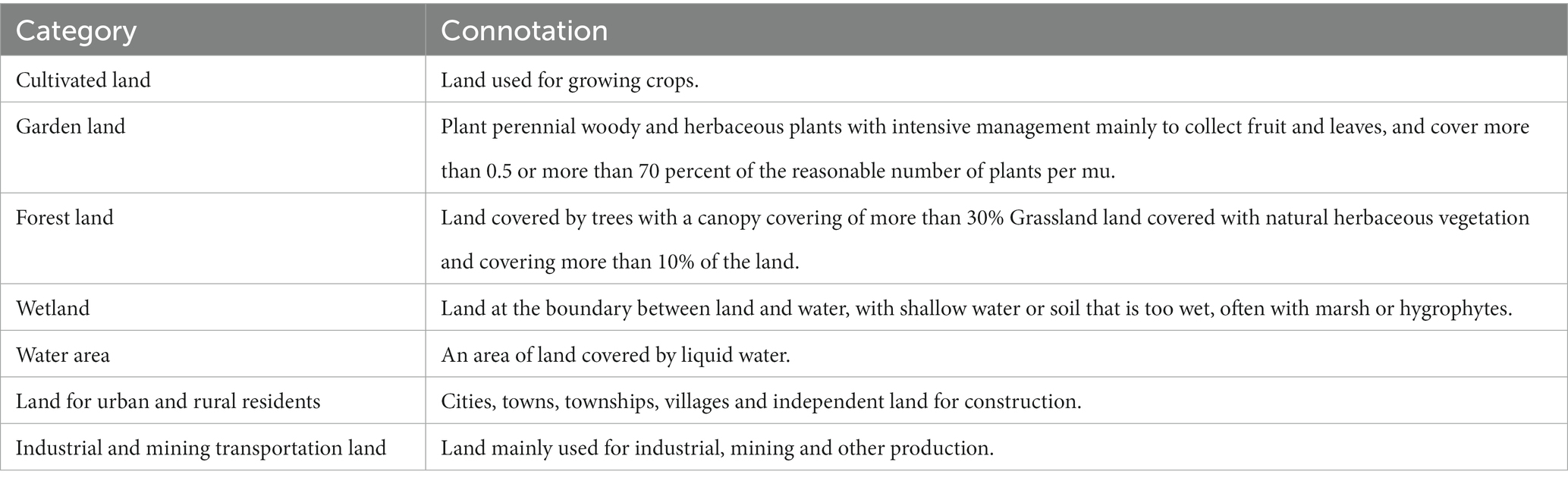
Table 1. Land use classification standard of Quyang County in 2020.
Appropriate evaluation unit is the basis for the evaluation of rural multi-functional space. When the evaluation unit is too large, it is difficult to reflect the spatial distribution characteristics of multi-function; and when it is too small, the measurement of rural function value will be inaccurate. Based on previous studies, a 300 × 300 m grid is selected as the evaluation unit. Quyang County is divided into 12,401 grids using the fishing net creation tool in ArcGIS 10.5. Since the spatial resolution of various types of data used in this paper are different, the resampling tool in ArcGIS 10.5 is used to unify their resolution to 300 m and assign the value to the grid divided in the previous step.
In order to eliminate the influence of the magnitude and measurement value of different data, the maximum difference normalization method is used to normalize the original data, and the formula is as follows:
Positive indicator:
Negative indicator:
Where, Yij is the normalized value, representing the original value of the j-th index in the i-th data, Xmaxj and Xminj represent the maximum and minimum value of the j-th index, respectively.
2.3. Research methods
The research framework of this paper includes three levels (Figure 2): First, the evaluation index system of rural PLEF is constructed, and the spatial distribution characteristics of rural PLEF are calculated and analyzed, respectively. Secondly, the CCD model is used to comprehensively analyze the CCD of PLEF and among every two functions. Finally, according to the CCD of PLEF, the identification scheme and zoning optimization strategy of the rural land spatial patterns are proposed.
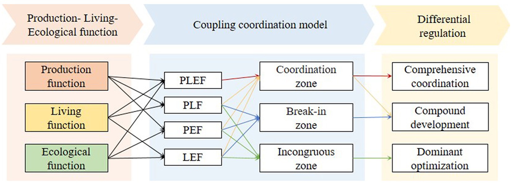
Figure 2. Research technology roadmap.
2.3.1. Function value measurement of PLES
The concept of PLES originated from the multi-functional agricultural system of the European Union (Yue, 2006), which is a functional space divided according to the products and services provided based on land use function (LUF) (Wei et al., 2021). However, land has multi-functional properties. A land type can have multiple land use functions such as PLEF, and its functional intensity will also differ in space (Deng and Yang, 2021). In this study, the rural PLEF value in the study area was obtained by constructing an evaluation system of rural PLEF.
2.3.1.1. Rural PLEF evaluation system
Influenced by the rural revitalization and national high-quality development strategy, the goals of rural PLEF are different (Yang et al., 2020; Zou et al., 2020). Based on previous relevant studies (Liu et al., 2019a; Yang et al., 2020; Yin et al., 2021), this study fully considers the characteristics of village development in the research area and follows the principles of typicality, comprehensiveness and systematicness. The research selected 24 indicators to establish an evaluation index system, which can fully reflect the most prominent features of rural PLEF in Quyang. For example, the topographic gradient was added to the evaluation system to characterize the impact of different landforms on ecological functions in rural areas of shallow mountains. In addition, relying on the rich ecological resources, Quyang has a huge potential for the development of cultural tourism industry. Therefore, indicators such as the number of farmhouses and the abundance of tourism resources are added to measure the development vitality of tourism industry, and they are taken as an important aspect of PF measurement. The indicator system and description are shown in Table 2.
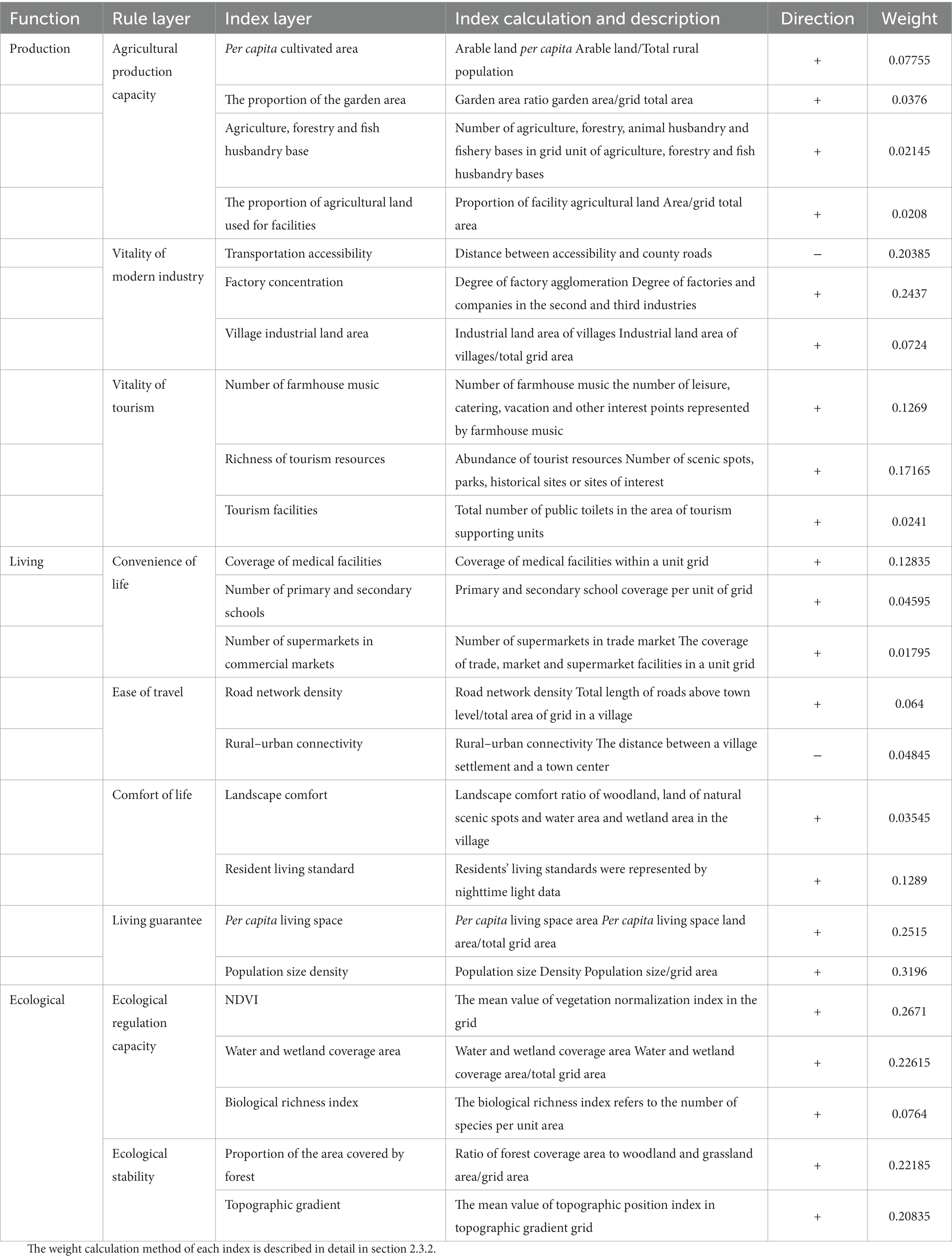
Table 2. Evaluation index and weight of ecological function of rural production and living.
2.3.1.2. Index calculation method
The PF is represented by the production capacity of agricultural products, the vitality of modern industry and tourism. Agricultural production capacity represents the development level of the primary industry by reflecting the ability to provide food, fruit and other agricultural products. Four indicators are selected in this study: per capital cultivated land area, the proportion of garden land area, base of agricultural, forestry, animal husbandry and fishery and proportion of agricultural land with facilities. Modern industrial vitality refers to the development vitality of the secondary industry that can effectively promote rural development. The value of modern industrial vitality is calculated by selecting transportation accessibility, factory aggregation degree and an industrial land area of villages. At the same time, Quyang has higher ecological advantages, cultural tourism and other tertiary industries have greater development potential, which is the main development direction of Quyang in the future. The tourism vitality value is calculated by selecting the number of farm entertainment, tourism resource richness and tourism facilities (number of public toilets).
The LF includes four functions: life convenience, travel convenience, life comfort and living security. In terms of convenience of life, the level of medical care, education, health and business services is the key to affecting rural life. Therefore, three indicators are selected: the number of public medical facilities owned by 1,000 people, the number of primary and secondary schools and the number of trade fairs. In terms of travel convenience, the greater the road network density, the more perfect the regional transportation facilities, and the more convenient the traffic. Urban and rural connectivity refers to the distance between village settlements and township centers. The smaller the distance, the better the connectivity between villages and townships. In terms of living comfort, landscape comfort and residents’ living standards are used to represent it. Among them, the living standard of residents is calculated by night light data, reflecting the economic situation and living consumption ability of residents. In terms of housing security ability, per capital living space area and population size density are used to represent it (relevant literature shows; Zhang et al., 2015; Wu et al., 2016; Yu et al., 2017: living space refers to the sum of urban and rural construction land, transportation land and scenic land).
The EF includes ecological regulation function and ecological stability function. Ecological regulation ability is calculated by vegetation normalized index (NDVI), water, wetland coverage area and biological richness index (BRI) (Yin et al., 2021). The larger the index value is, the richer the biological species and vegetation are, and the better the ecological regulation ability is. BRI represents the species richness index, and the calculation Formula (3) is as follows:
In the formula, Abio is the normalized system index, and the reference value is 511.264. Sf, Sg, Sw, Sc, Scon, Sn, and St are the total area of woodland, grassland, water area, cultivated land, construction land, unused land and regional land, respectively.
NDVI index reflects the degree of regional vegetation coverage. The calculation is as follows:
In the formula, RNIR and RR represent reflectance of near-infrared band and red band, respectively.
The ecological stability function is the ability to protect the ecosystem from pollution and disturbance, which is represented by the forest coverage rate and topographic position index and reflects the regional ecological vulnerability. The topographic potential index is a topographic factor that integrates altitude and slope factors, and its advantage is that it can comprehensively reflect topographic conditions at a certain point. Where the topographic gradient is high, the natural ecosystem is disturbed and damaged to a low degree, and the importance of soil conservation function is higher (Shi et al., 2021). The calculation of the topographic potential index is shown in Formula (5):
In the formula, T represents the topographic position index, E and S represent the elevation (m) and slope (°) of a point respectively, and E0 and S0 represent the average elevation (m) and average slope (°) of the whole research area, respectively.
2.3.2. Weight calculation method
Based on establishing the indicator system, the weight of each indicator is obtained by combining subjective and objective methods, in order to avoid defects such as over-reliance on expert opinions or underestimation of data statistical rules and minimize information loss. First, the entropy weight method (EWM) is used to objectively weight 24 indicators. Secondly, according to the principle of Analytic Hierarchy Process (AHP), we construct a judgment matrix, invite 20 experts and scholars in relevant fields to score the index, and calculate the subjective weighting result after passing the consistency test. Finally, Finally, referring to relevant literatures (Yang et al., 2020), the average of EWM and AHP results were calculated to obtain the comprehensive weight of each index.
The EWM preliminarily determines its weight according to the information size of each index. The calculation steps are as follows:
1. The weight of the j-th index of the i-th order parameter is defined as Pij (I = 1, 2… m; J = 1,2…, n), and its expression is:
The entropy value of the j-th index can be expressed as:
The difference degree wj of entropy value hj of the j-th index is:
The final weight βj of the j-th index can be calculated as follows:
2.3.3. PLEF coupling coordination degree model
The coupling coordination model can quantify the coordination effect and accurately coordinate the development degree of all elements in PLEF system (Yin et al., 2021). Therefore, we introduce the coupling coordination index to construct the CCD model. Firstly, the degree of coupling coordination among PLEF was measured by evaluating the production, living and ecological functions of every geographic grid. Then, the classification of natural discontinuities (Jenks) was used to divide the CCD into coordination zone, break-in zone and incongruous zone. Among them, coordination region refers to the increasingly strong coupling between PLEF, and orderly development, in a high level of coupling coordination period. The break-in zone means that PLEF begins to develop harmonically, showing the characteristics of benign coupling coordination. Discordant zone refers to low PLEF interaction and disordered development. The specific calculation process is shown in Formulas (10)~(12).
In Formula (9), C represents coupling degree, where C∈[0,1], the greater the value of C, the stronger the interaction among PLEF, Pi, Ri and Ei represent the evaluation scores of PF, LF and EF, respectively. In Formula (10), T represents the coordination index among PLEF. α, β and γ are the undetermined coefficients of PF, LF and EF, respectively. According to the existing research results (Wang and Tang, 2018; Wei et al., 2021) and expert consultation, the undetermined coefficients are determined as α = β = 0.3 and γ = 0.4. In Formula (11), D represents the CCD between PLEF.
In addition, it is important to further analyze the advantages and disadvantages of the coupling coordination state among every two PLEF. Therefore, to explore the coupling coordination state between each two PLEF, the CCD model is further evolved, as shown in Formulas (13)–(15). According to the existing research results, α = β = 0.5 when calculating CCD between PF and LF; α = 0.45, γ = 0.55 when measuring CCD between PF and EF; β = 0.45, γ = 0.55 when measuring CCD between LF and EF.
3. Results and analysis
3.1. PLEF evaluation results and analysis of land
Through the rural “production-living-ecological” function evaluation system, the evaluation values of rural PLEF in Quyang County in 2020 are obtained, as shown in the figure. In terms of evaluation value, the average score of ES > PS > LS indicates that the development level of rural ecological space and production space in Quyang County is relatively good, while the development level of living space is relatively backward. In terms of spatial distribution, strong developing villages are distributed around the central city of Hengzhou Town, medium-developing villages are mostly distributed around Hengzhou Town and Lingshan Town, and weak villages are embedded in the hills and mountains in the south and north of the regional edge.
3.1.1. Production function
Under the comprehensive influence of resource endowment, landform, transportation location and other factors, the spatial differentiation of rural production function in Quyang County is obvious (Figures 3A). The distribution of the production function of the whole region was low in the north and high in the south, with Hengzhou town and Lingshan town as two levels and decreasing outwards. The areas with a higher level of PF development are mostly located in Hengzhou, Luzhuangzi, Yangping, Dicun, and Lingshan. Among them, villages located in Hengzhou Town and Yangping Town in the south of the county have large populations, and strong agricultural production capacity. Besides, they are the main production base of the carving and Ding porcelain industry, with a large number of enterprises and factories, a large area of industrial land, and a high degree of rural industrial development. The moderately developed areas are located in the flat area in the central part of the county seat and in the south of the county seat, where are flat, rich in arable land resources, and have strong agricultural production capacity. In addition, they have rich tourism resources such as folk culture and natural scenery and have outstanding development of leisure agriculture and folk culture tourism. Those areas with weak development levels are distributed in the surrounding areas of the county such as the southeast and northwest regions, which are located in mountains and hills with complex terrain. These areas are not conducive to large-scale production and operation activities, so the development of rural industries is not dynamic enough, showing a low level of development.
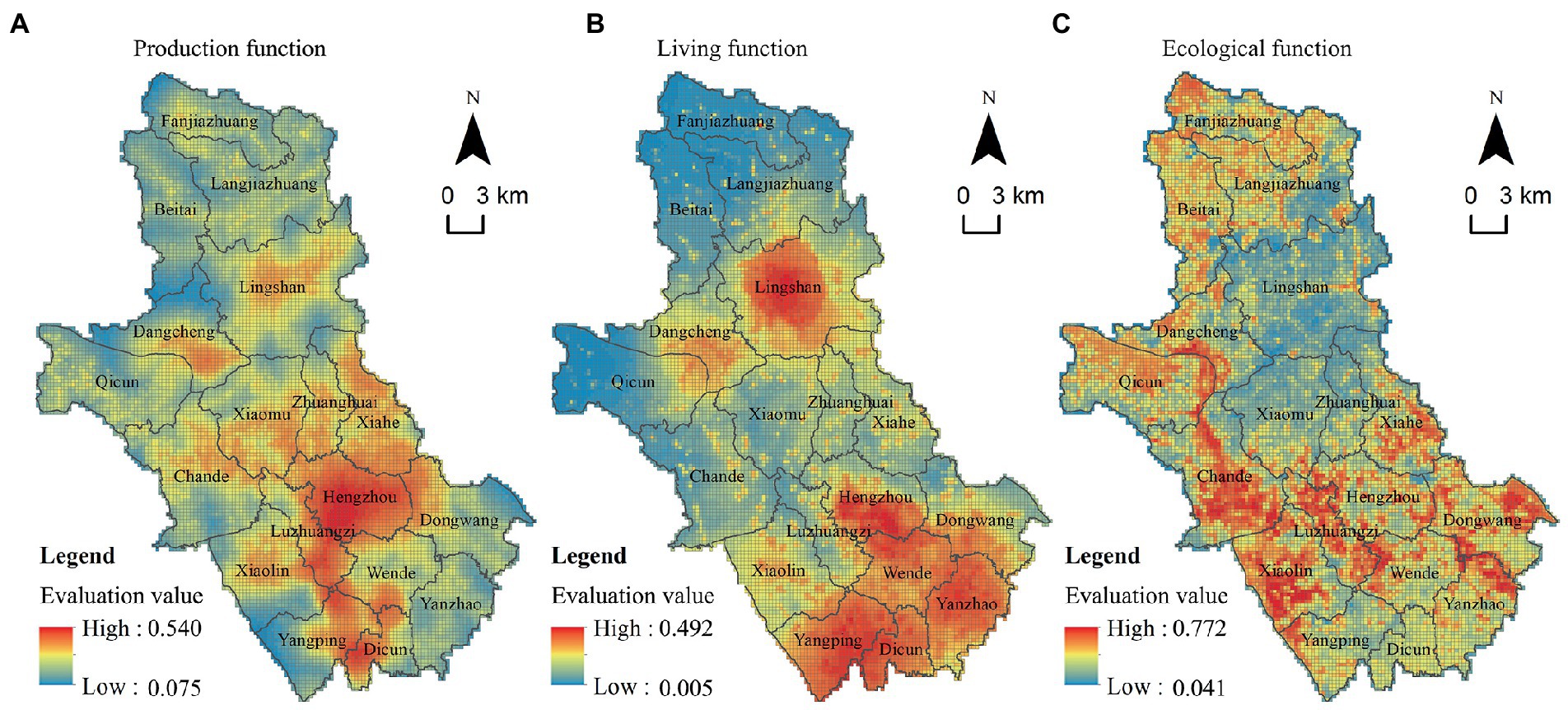
Figure 3. PLEF evaluation value of Quyang County. (A) Production function. (B) Living function. (C) Ecological function.
3.1.2. Living function
The overall score of rural living function in the region is low, and most villages are not prominent in terms of life convenience, travel convenience and urban–rural connectivity, showing an underdeveloped state. The spatial distribution of living function in the whole region is similar to that of production space, showing a spatial characteristic of high in the north and low in the south (Figures 3B). The living function development level is strong in the central area of Hengzhou Town and other areas. With perfect public health care, education, transportation and other public management and service facilities, Hengzhou Town has absolute development advantages. At the same time, Anxia and other villages located in the south of the county have a large area of forest land, water and other natural scenery lands. These areas have a good natural background and high landscape comfort, so the village life function is relatively strong. In addition, Lingshan Town in the north, as the secondary center of county development, has relatively perfect infrastructure development and a higher level of economic development, so its living function score is also high. The villages with poor living functions are located in the north to the west of the county. Due to the influence of terrain and other factors, these areas have a small population, insufficient supporting facilities for living functions and low living convenience.
3.1.3. Ecological function
The development of rural ecological function in the region is mainly affected by topography, ecological resources, urban development intensity and other factors. Quyang County is rich in landscape resources and has high coverage of forest land. Overall, the ecological function score of the whole region is relatively high, and the ecological space presents the distribution characteristics of “mountain by water, high in the west and low in the east” (Figures 3C). Villages with high ecological function values are mainly located in Xiaolin, Chande and other towns, where they have flat terrain, a large area of the natural water system and artificial trunk canal, and a high BRI. Moreover, they are all over a large area of plain economic forest, with strong ability of ecological regulation and outstanding ecological function. Qingshan, Honggang and other villages located in shallow mountainous areas in the northern part are characterized by complex terrain, large areas of gneiss economic forest and relatively high vegetation coverage, so the ecological environment is good. Towns with weak ecological function are distributed in the east of the county, where the vegetation coverage is low. And industrial development in these regions is dominated by industrial and agricultural production, which threatens the quality of the ecological environment.
3.2. PLEF coupling coordination degree analysis
3.2.1. Coupling coordination degree of PLEF
Through the CCD model, the CCD and spatial distribution diagram of “production-living-ecological” functions in Quyang County in 2020 were obtained (Figure 4). Jenks was adopted to divide the CCD of PLEF into three types (incongruous zone, break-in zone and coordination zone), as shown in Table 3. Overall, the degree of coupling coordination among every two PLEF is generally low in the north and high in the south in Quyang. The ecological function in the northern mountainous area is good, but due to the limitation of terrain and other factors, its PF and LF have not been developed synchronously and harmoniously. The PF and LF of the southern plains have a high degree of coordinated development. At the same time, due to the abundant ecological resources of the villages in the shallow mountainous areas, their ecological functions also develop synchronously.
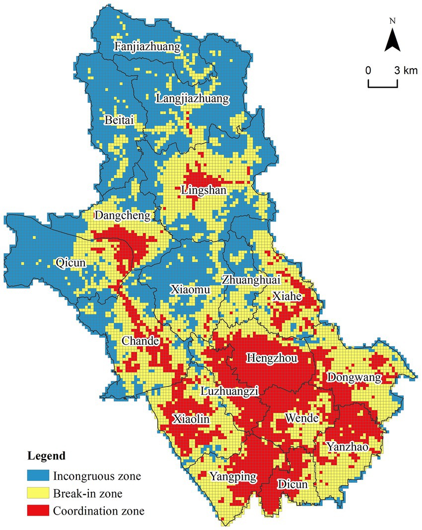
Figure 4. Spatial distribution of PLEF coupling coordination degree in Quyang County.
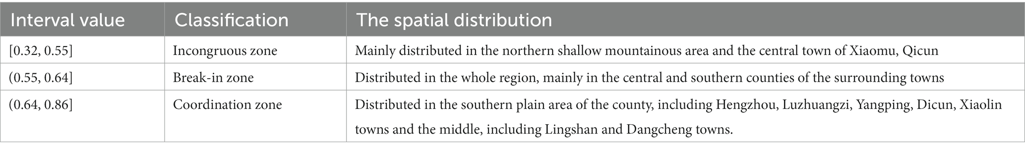
Table 3. Classification and distribution of PLEF coupling coordination degree in Quyang County in 2020.
3.2.2. Coupling coordination degree of every two PLEF
According to Formulas (12)–(14), the coupling and coordination level of every two PLEF in Quyang County in 2020 is calculated, and they were divided into three levels of coordination, break-in and incongruous by Jenks. However, due to the different coordination degrees of every two PLEF, the breakpoint values of divided intervals are also different (Table 4), and the spatial distribution is shown in Figure 5. In general, the degree of coupling coordination of every two PLEF is generally low in the north and high in the south Although EF of the northern mountainous area is better, PF and LF cannot develop synchronously due to the restriction of topography and other factors, while PF and LF of the southern plain area are highly developed synchronously, and EF is also developed synchronously due to the rich ecological resources in the shallow mountainous area.
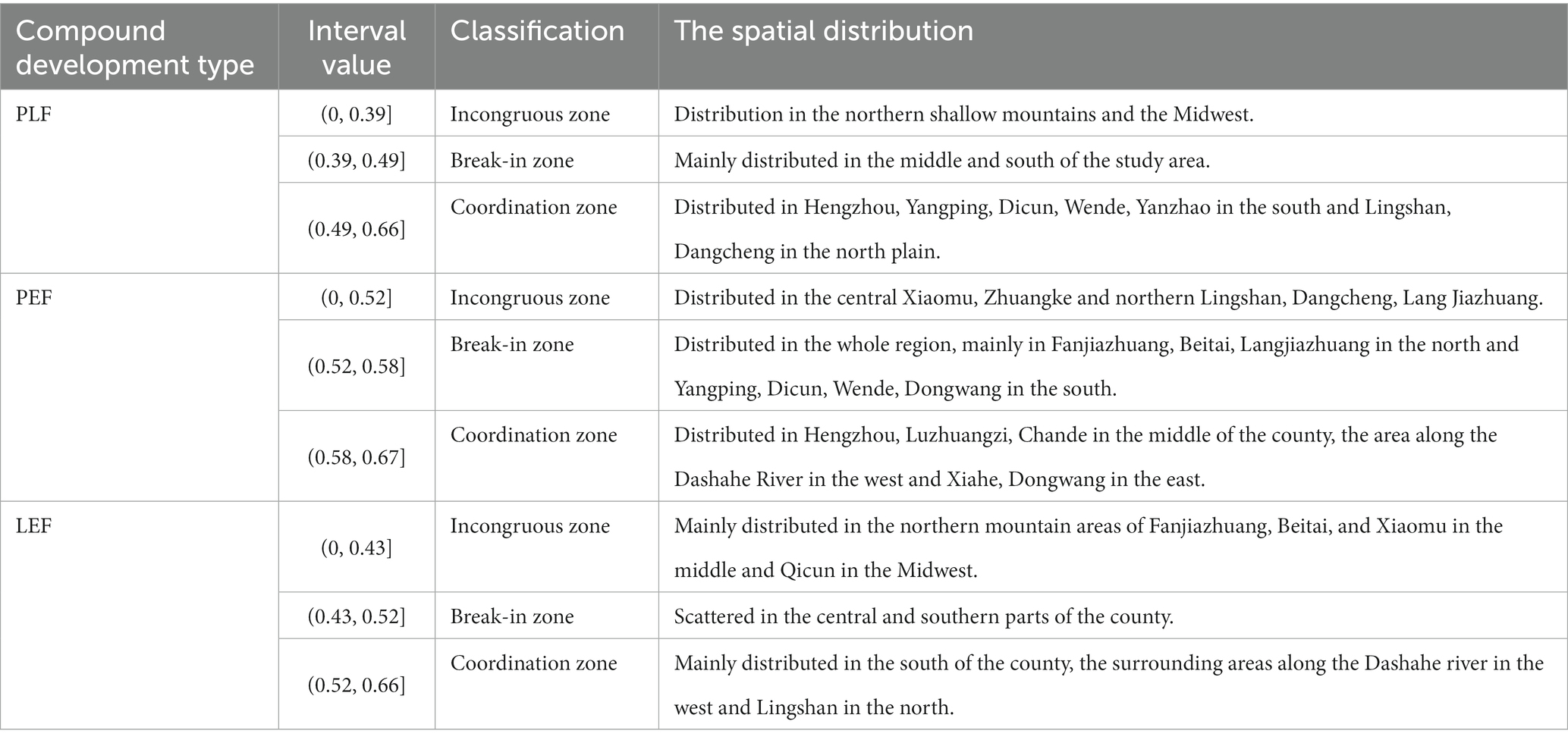
Table 4. Classification and distribution of PLF, PEF, LEF coupling coordination degree in Quyang County in 2020.
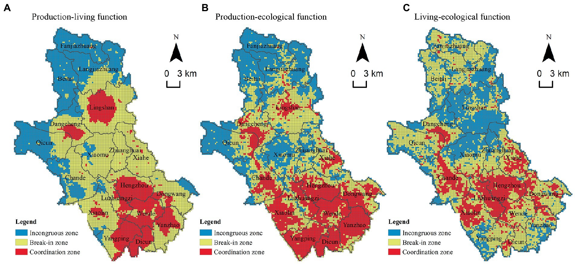
Figure 5. Spatial distribution of coupling coordination degree of PLF, PEF, and LEF in Quyang County in 2020. (A) PLFs. (B) PEFs. (C) LEFs.
4. Pattern optimization and zoning control
4.1. Reconstruction of rural development pattern based on the CCD of PLEF
The essence of optimizing regional spatial patterns is to improve regional sustainable development capacity and provide spatial guarantee for social development, livable life and good ecology by optimizing regional spatial structure and layout. Because PLEF has different advantages and disadvantages in different spatial units, weak functions should be enhanced in the process of spatial optimization to achieve the goal of coordinated development of PLES.
According to the results of CCD, we designated the coordination region of PLEF as the equilibrium coordination space of PLEF. Then, we compared the relative advantages of coupling and coordination degree among every pair of PLEF within the break-in zone and incongruous zone and divided the coordination zone and break-in zone of PLF, PEF, and LEF into production-living space (PLS), production-ecological space (PES), and living-ecological space (LES). Finally, the incongruous zone among every PLEF was divided into a single production, living or ecological space, as shown in Figure 2. However, the area of the identified single living space is very small and the corresponding land use type has both productive and ecological functions. Therefore, the single living space was classified as production-living compound space or life-ecological compound space, and finally, the PLES pattern of Quyang County was obtained.
PLEF can be defined as six types of space: production-living-ecological balance space (PLEBS), production-living space (PLS), production-ecological space (PES), living-ecological space (LES), ecological space (ES), and production space (PS) (Figure 6). The proportions of various types of space were 23.43, 19.05, 8.42, 23.55, 25.28, and 0.38%, respectively. On the whole, the spatial pattern of PLEF in the study area is dominated by ES space in the northwest and PLEBS in the south. Hengzhou and Lingshan are the high-quality coupling coordination core, and PLS, LES and PES gradually transition to the surrounding area. PLEBS and ES account for a larger proportion, followed by PLS and LES.
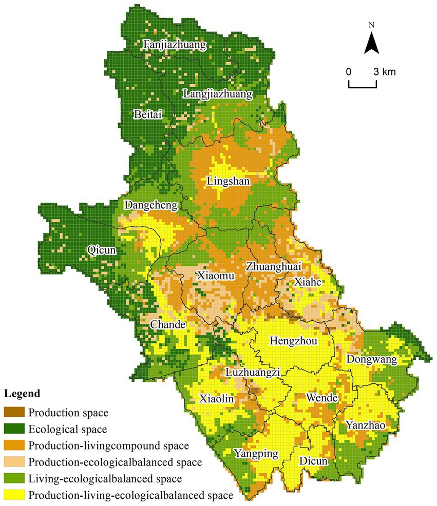
Figure 6. Rural PLES recognition results at grid scale in Quyang County.
4.2. Zoning control of rural PLEF
A geographic grid can describe spatial heterogeneity of PLEF in detail, but it is not conducive to spatial regulation. Therefore, in order to ensure that the optimization results of PLES have good practical significance, we took villages as the basic unit, counted the value of PLEF of geographic grid within every village, calculated their CCD, and adopted the spatial pattern recognition method above to optimize the PLEF at the village unit scale. On this basis, combined with some scholars’ research results (Yu et al., 2020; Fu et al., 2021; Gao et al., 2021) and the development characteristics of various villages, they were divided into three development directions: dominant optimization type, compound development type and comprehensive coordination type. There are altogether five core development types and functional types as shown in Table 5, and development suggestions are put forward for different types.
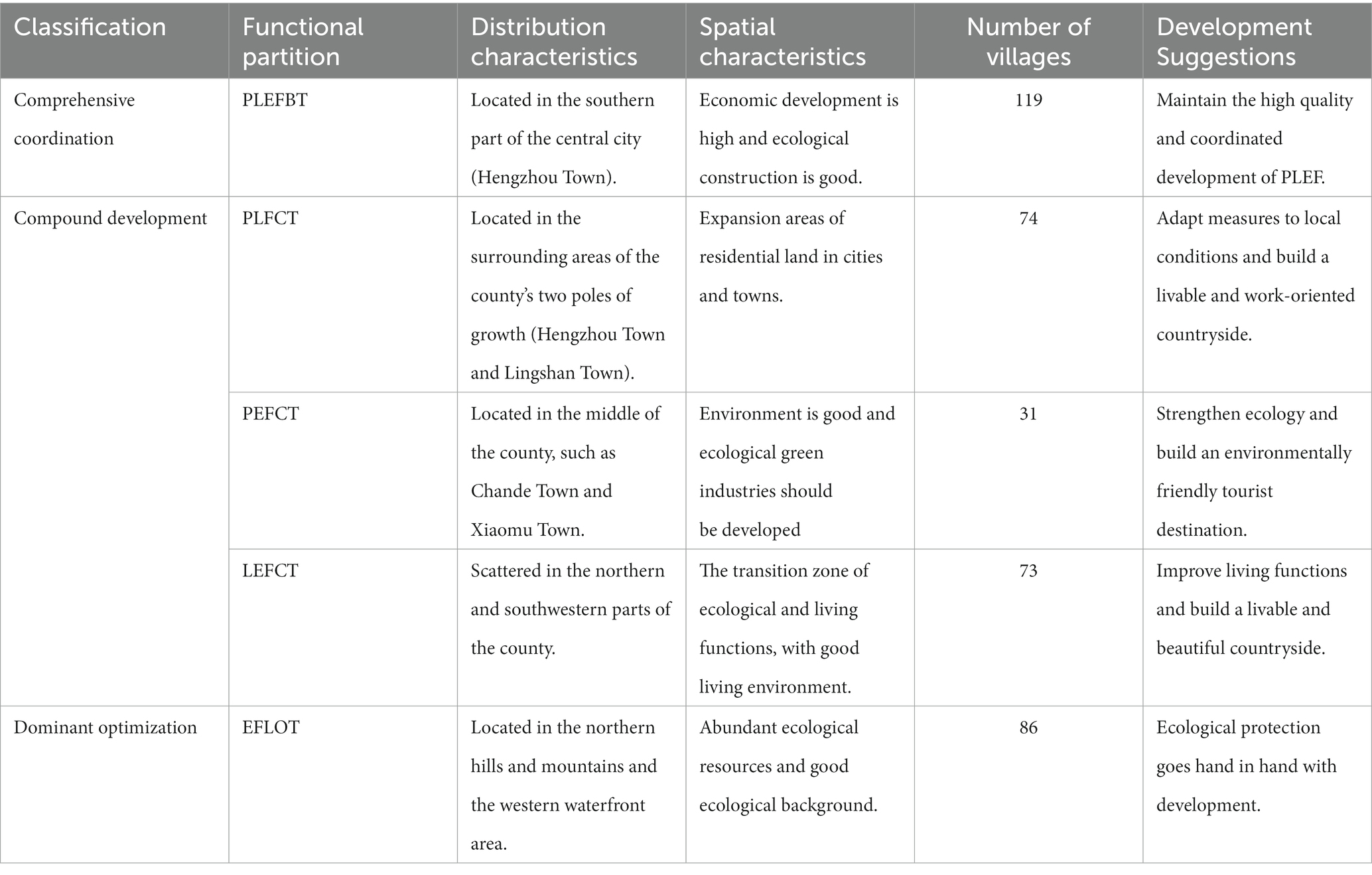
Table 5. Quyang county area each rural development type statistics.
The results showed that the spatial distribution of PLES optimization based on administrative unit scale is consistent with that of geographic grid scale, and the types and proportions of PLEF delineation are roughly the same. The production-living-ecological balanced type (PLEFBT)] villages correspond to PLEBS, the three functional divisions of function compound type (FCT) villages correspond to PLS, PES and LES respectively, and the single-function leading type (FLOT) villages correspond to single function space. Among them, the dominant optimized villages only have a kind of ecological function leading optimization type (EFLOT), which lacks the production dominant function compared with the geographical grid. The reason is that the production space delineated by the fine geographic grid occupies a small proportion of the village scale and has been classified into FCT villages (Figure 7).
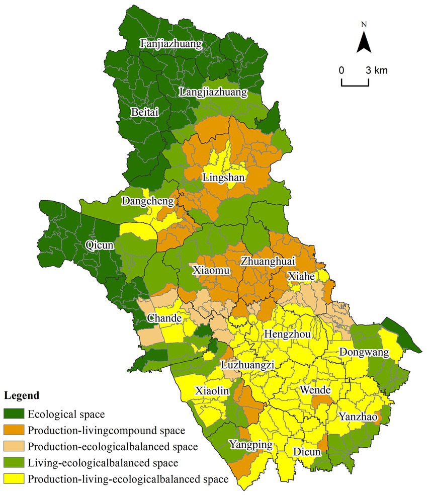
Figure 7. Optimization results of rural PLES partition in Quyang County at village scale.
4.2.1. Production-living-ecological balanced type (PLEFBT)
It is mostly located in the south of the county, including Hengzhou, Luzhuangzi, Wende, Yangping and other towns. It is characterized by strong development and high coupling coordination of PLEF, which is the plain area in Quyang’s “high in the north and low in the south” topographic pattern. Such functional areas have obvious advantages in traffic location, relatively prominent rural production and living functions, well-developed tourism and characteristic industries with “Carving and Ding porcelain” as the core, with high economic development, sound life service facilities and high quality of life. At the same time, there are many rivers and natural mountain resources such as Jiahe Mountain Natural Scenic spot in this region, which have high ecological function value.
In the future, we should give full attention to the advantages of ecological environment and industrial development in this region and develop ecological green industries on the basis of further improving environmental quality and ensuring ecological safety. Meanwhile, we should promote “culture + tourism + ecological” depth fusion and the sustainable development of PLEF.
4.2.2. Production-living compound type (PLFCT)
It is mainly located around the two growth poles (Hengzhou Town and Lingshan Town), and it is the expansion area of residential and living land of cities and organized towns, showing that PF and LF are well-developed while EF is weak. The population density of this area is relatively high, accompanied by certain industrial production and living pollution poses a great threat to ecological security. In addition, the vegetation coverage of this area is low and its ecological environment quality and living environment quality need to be improved.
In the future, it is advisable to make a rational layout of its space based on its own and its surrounding rural space functions and characteristics: (1) Villages with potential development of EF (such as Beiguzhuang Village in the north of Hengzhou Town, which is close to natural scenic spots) should focus on improving environmental quality, developing green industries such as farm entertainment, leisure and sightseeing agriculture, and further developing into “product-ecological” function coupling coordinated villages; (2) Villages with potential PF (such as the villages in the south of Lingshan town that focus on fixed porcelain production) should further improve the processing technology and production mode to realize clean production and form a boutique tourist town featuring fixed porcelain production; (3) Villages with high population density and strong LF should continue to maintain the living space function to create livable villages; (4) Villages with coordinated development of PF and LF are important areas of agricultural production, which should strictly observe the red line of cultivated land, improve public infrastructure such as transportation and logistics, and create a balanced village area of life and production suitable for living and production.
4.2.3. Production-ecological compound type (PEFCT)
These types of villages are mostly distributed around PLEBS, mainly including towns located on the east and west sides of the central county such as Chande Town, Xiahe Town and Xiaolin Town. These areas are characterized by strong PF and EF but weak LF. These villages have flat terrain, rich arable land resources, high degree of land development and utilization, and are adjacent to Jiahe Mountain scenic area and other prominent ecological advantages of the region, so they have both agricultural and ecological tourism development conditions. In the future, modern agriculture such as ecological agriculture, facility agriculture and tourism and leisure industry can be vigorously developed according to the specific requirements of township development. Besides, we should focus on the protection of environment, deal with the relationship between tourism and ecology, and build an environmentally friendly tourist destination.
4.2.4. Living-ecological compound type (LEFCT)
These villages are scattered around the north and southwest of Quyang County, where is the transition zone between ecological and living functions. This region has high vegetation coverage and rich tourism resources, leading to relatively developed tourism. However, due to terrain constraints, the construction of public service facilities and infrastructure lags behind. In the future, the construction of transportation, education and other facilities should be appropriately strengthened within the ecological carrying capacity to enhance life function.
4.2.5. Ecological function leading optimization type (EFLOT)
These villages are mainly located in the hills and mountains in northern Quyang County, the waterfront space in the west of the county, a small amount of distribution along the Dasha River and the central forest area. These villages mainly focus on ecological function and have high habitat quality, where main land use types are woodland, grassland and water area. In the future, based on improving the quality of ecological environment, this region should give full play to its ecological advantages, moderately develop ecological tourism and ecological agriculture, and take the road of sustainable development with the parallel protection and development. In the northern mountainous area of the county, ecological protection is the main function, and ecological control of “mountains, rivers, forests, fields and lakes” is strengthened. Ecological engineering construction based on soil and water conservation, wetland restoration and afforestation is emphasized in Taihang Mountain ecological belt, and ecological environment and biodiversity are strictly protected. In the western part of the county, we should seize the natural background advantages such as the Dashahe landscape belt and develop the ecological leisure tourism moderately.
5. Discussion
This paper identified and optimized rural spatial patterns based on the function CCD of rural PLEF. Based on previous studies, this paper explored, improved and innovated the research scale, analysis methods, evaluation indexes and optimization ideas in the field of rural PLEF. First of all, in terms of research scale, this study breaks through the limitations of existing studies that take counties and towns as PLEF evaluation units (Liu et al., 2019a; Yin et al., 2021). With fully considering the spatial differences within the administrative units, the analysis method of combining the geographical grid and the administrative village is adopted. The spatial heterogeneity of the village PLEF and its CCD is described in detail through the geographical grid, and the spatial pattern of PLEF is reconstructed with the village area as the basic unit. This makes this study depict the spatial differentiation of PLEF on a more detailed scale, and the relevant conclusions are more reliable, which can provide more efficient guidance for rural land spatial governance. Secondly, in the aspect of PLEF evaluation, this study makes up for the defect that the evaluation indicators selected in previous studies are not closely combined with the emerging geospatial data. In addition to remote sensing image, DEM, land use status data and other data, we also added multi-source spatial data such as POI, NDVI, night light, population size, etc. at the indicator level. The PLEF evaluation results obtained are more comprehensive and more regionally targeted than the previous function assignment based on land use data, providing practical reference value for regional industrial revitalization and sustainable development. It can be seen from the PLEF evaluation results that the ecological function of the study area has developed well, which is closely related to the rich natural resource elements and the construction requirements of the ecological safety barrier in the area, and conforms to its actual development, which has laterally confirmed the feasibility and reliability of the evaluation method used in this paper. Finally, in the aspect of rural spatial pattern optimization, previous studies mostly evaluated the spatial dominance of PLEF, ignoring the multi-function of land and the goal of coordinated development of PLEF. Based on CCD judgment of PLEF and referred to the previous studies and expert opinions, this study put forward a reconstruction of the spatial pattern of rural optimization scheme that is more in line with the concept of sustainable development and adapts to local conditions, providing a decision-making reference for the harmonized development of territorial space.
Due to the difference between the research scale and the PLEF evaluation system, the CCD evaluation results and the zoning optimization scheme obtained in this paper are different from previous studies (Liu et al., 2019a; Yu et al., 2021). First of all, different from the previous conclusion that villages with high PLEF CCD are mostly located around scenic spots and other ecological resources, this study proposes that they are mainly distributed in areas with high level of economic development, perfect facilities and convenient transportation. At the same time, considering the location characteristics of Quyang County, this study adds terrain into the PLEF evaluation system and considers that it is the main factor affecting PLEF CCD in shallow mountainous villages. The northern mountains and the central hilly areas are affected by the terrain, and the infrastructure construction is difficult, and some areas are concentrated with industrial land, causing some pollution to the ecological environment, so the PLEF CCD is generally lower than that of the central plains. Finally, according to PLES pattern optimization at grid scale and village scale, the two results are generally similar. Both grid scale and village scale lack single living space, which is due to the poor living function in the region and the inseparable production and life of people. So there is no space with leading living function. Compared with the evaluation results of grid scale, the results of village scale also lack dominant type of production function. The reason for this phenomenon is that the production space occupies less grid, which is difficult to reflect in the village scale.
Rural PLES is an important concept of sustainable development in territorial spatial layout, and is the result of shifting to coordinated development of economy, society, environment and human activities with economic development as the core (Zeng et al., 2021). Driven by policies such as rural revitalization and combined with the comprehensive impact of regional natural resources background and socio-economic differences, rural industries, culture, ecology and other factors and their patterns need to be optimized. In this context, the findings presented in this research can provide objective basis for spatial pattern optimization and easy to implement technical methods, meanwhile, it is conducive to promoting land spatial governance and rural revitalization development in Hebei shallow mountainous areas. In addition, the practical village planning of “multiple compliance” in the new period is still in the exploratory stage, and a relatively perfect planning idea has not been formed (Xiong et al., 2021). In the new era of big data and smart city, scholars in related fields at home and abroad have explored and tried to reconstruct and optimize rural spatial patterns by using existing multi-source data and technological means of intelligent science. How to guide the coordinated development of rural land space through scientific and effective technical means is a subject worthy of further study in the future. The research methods and results presented in this paper can provide references for such attempts.
The study had two major limitations. (1) Due to the limited access to village-level statistical data, the selection of indicators is not perfect. When constructing the PF development index system, there is a lack of data on the output of rural agricultural products such as vegetables and meat, so only indicators such as per capita cultivated land area and POI of agriculture, forestry, animal husbandry and fishery bases are considered to represent the production capacity of agricultural products. In the future, the selection of relevant indicators and acquisition methods should be further discussed. (2) In addition, the spatial pattern optimization method adopted in this paper is somewhat subjective, and objective models or methods should be further explored to quantitatively evaluate PLEF intensity in the future.
6. Conclusion
From the perspective of coupling coordination of rural PLEF, this study comprehensively uses multi-source fine-grained data such as POI and land change survey data to identify and optimize rural spatial development patterns. The main conclusions are the following:
(1) There are clear differences in values of PF, LF, and EF in Quyang County. The average value and maximum value of functional intensity are in the order of EF > PF > LF. The development level of EF is good while the level of LF is poor. This indicates that the shallow-mountain counties are rich in ecological resources and have high potential for EF development. Meanwhile, due to the influence of terrain and other factors, the construction of their LF is difficult and their development degree is relatively weak. The distribution of production function was low in the north and high in the south, with Hengzhou town and Lingshan town as two cores and decreasing outwards. The spatial distribution of LF and PF was similar. The ecological space showed the distribution characteristics of “high in the north and south, low in the middle; high in the west and low in the east.” The areas with strong ecological function were mainly spread over the mountainous and hilly region in the north, the forest land coverage in the south and the reservoir area in the west.
(2) The spatial distribution of PLEF coupling coordination in Quyang is “low in the north and high in the south,” which is highly similar to topographic features. The coordination zones of PLEF are mainly distributed in the south plain with better economic development, while the incoordination zones are mainly located in the mountainous areas in the north and the hilly areas in the middle of the county. These results indicate that terrain has a significant impact on PLEF coupling coordination in shallow mountain areas. The villages with high CCD are mainly distributed in plain areas with developed economy and perfect infrastructure configuration. The LF and PF of this region are better, and they develop in coordination with ecological functions. Most of the uncoordinated areas are mountainous and hilly areas with industrial land agglomeration or imperfect infrastructure, where the ecological environment is seriously damaged and the development of PF and LF are also hindered. Therefore, there is a significant contradiction in PLEF development.
(3) Rural PLES were identified as six types of space -- PLEBS, PLS, PES, LES, ES, and PS. The spatial pattern of PLEF in the study area is mainly characterized by ES in the northwest and PLEBS in the south. Hengzhou and Lingshan towns are the high-quality coupling coordination core, and PLS, LES, and PES gradually transition to the surrounding areas. PLEBS and ES account for a larger proportion, followed by PLS and LES. In general, the characteristics of shallow mountain areas and counties are that the proportion of ES is higher, and the development trend of ecological function is better, which is in line with the development goal of regional ecological construction.
(4) The rural PLES zoning optimization in Quyang County can be divided into three development directions: leading function optimization type, compound development type and balanced coordination type, and then can be subdivided into five development types: PLEFBT, PLFCT, PEFCT, LEFCT, and EFLOT. Among them, the PLEFBT villages should further emphasize the high-quality coordinated development, while the FCT villages should integrate the characteristics of regional development and the characteristics of surrounding villages to optimize the PLEF development according to local conditions. EFLOT villages should adhere to the principle of ecological priority, ensure ecological security, give play to the advantages of regional ecological functions, and develop ecological industries such as eco-tourism.
Data availability statement
The original contributions presented in the study are included in the article/supplementary material, further inquiries can be directed to the corresponding author.
Author contributions
SW and AN contributed to conception and design of the study. SW and JL organized the database. SW, JL, and YS performed the statistical analysis. SW wrote the first draft of the manuscript. SW, JT, and AN conducted writing, review, and editing. JT contributed to supervision and funding acquisition. All authors have read and agreed to the published version of the manuscript.
Funding
This study was supported by the National Natural Science Foundation of China (NSFC) (grant numbers 52078320 and 52078330).
Conflict of interest
The authors declare that the research was conducted in the absence of any commercial or financial relationships that could be construed as a potential conflict of interest.
Publisher’s note
All claims expressed in this article are solely those of the authors and do not necessarily represent those of their affiliated organizations, or those of the publisher, the editors and the reviewers. Any product that may be evaluated in this article, or claim that may be made by its manufacturer, is not guaranteed or endorsed by the publisher.
Footnotes
References
Cao, W., Zhou, S., and Wu, S. (2012). Research progress of urban smart growth and land use. Urb.Prob. 30–36. doi: 10.13239/j.bjsshkxy.cswt.2012.12.006
Chen, L., Wang, J., Fu, B., and Qiu, Y. (2001). Land-use change in a small catchment of northern loess plateau, China. Agric. Ecosyst. Environ. 86, 163–172. doi: 10.1016/S0167-8809(00)00271-1
Chen, H., Yang, Q., Su, K., Zhang, H., Lu, D., Xiang, H., et al. (2021). Identification and optimization of production-living-ecological space in an ecological foundation area in the upper reaches of the Yangtze River: A case study of Jiangjin District of Chongqing, China. Land 10:863. doi: 10.3390/land10080863
Deng, C., Wang, C., and Wang, Z. (2018). The restructuring symbiotic paths of rural production, living and Econogy space—based on the analysis of symbiotic interfaces among peasants. Chin. J. Agric. Resour. Region. Plan. 39, 96–103. doi: 10.7621/cjarrp.1005-9121.20180314
Deng, Y., and Yang, R. (2021). Influence mechanism of production-living-ecological space changes in the urbanization process of Guangdong Province, China. Land 10:1357. doi: 10.3390/land10121357
Dong, G., Ge, Y., Jia, H., Sun, C., and Pan, S. (2021). Land use multi-suitability, land resource scarcity and diversity of human needs: A new framework for land use conflict identification. Land 10:1003. doi: 10.3390/land10101003
Duan, Y., Wang, H., Huang, A., Xu, Y., Lu, L., and Ji, Z. (2021). Identification and spatial-temporal evolution of rural “production-living-ecological” space from the perspective of villagers’ behavior – a case study of Ertai town, Zhangjiakou City. Land Use Policy 106:105457. doi: 10.1016/j.landusepol.2021.105457
Fu, C., Tu, X., and Huang, A. (2021). Identification and characterization of production–living–ecological space in a central urban area based on POI data: A case study for Wuhan, China. Sustainability 13:7691. doi: 10.3390/su13147691
Fu, X., Wang, X., Zhou, J., and Ma, J. (2021). Optimizing the production-living-ecological space for reducing the ecosystem services deficit. Land 10:1001. doi: 10.3390/land10101001
Gao, H., Wang, Z., Wang, T., and Yang, Y. (2021). Optimizing the layout of rural settlements in Zhongquan town under the coordination of three living spaces. Sci. Surv. Mapp. 46, 176–182. doi: 10.16251/j.cnki.1009-2307.2021.03.026
Huang, A., Xu, Y., Lu, L., Liu, C., Zhang, Y., Hao, J., et al. (2020). Research progress of the identification and optimization of production-living-ecological spaces. Prog. Geogr. 39, 503–518. doi: 10.18306/dlkxjz.2020.03.014
Ji, Z., Liu, C., Xu, Y., Huang, A., Lu, L., and Duan, Y. (2020). Identification and optimal regulation of the production-living-ecological space based on quantitative land use functions. Trans. Chin. Soc. Agric. Eng. 36, 222–231. doi: 10.11975/j.issn.1002-6819.2020.18.027
Jiang, Z., and Zeng, J. (2010). Analysis of spatial optimization in Chinese countryside based on spatial scarcity. Stud. Pract. 23–29. doi: 10.19624/j.cnki.cn42-1005/c.2010.12.003
Li, J., Sun, W., Li, M., and Meng, L. (2021). Coupling coordination degree of production, living and ecological spaces and its influencing factors in the Yellow River Basin. J. Clean. Prod. 298:126803:126803. doi: 10.1016/j.jclepro.2021.126803
Liao, L., Dai, W., Chen, J., Huang, W., Jiang, F., and Hu, Q. (2017). Spatial conflict between ecological-production-living spaces on Pingtan Island during rapid urbanization. Resour. Sci. 39, 1823–1833. doi: 10.18402/resci.2017.10.03
Liao, G., He, P., Gao, X., Lin, Z., Huang, C., Zhou, W., et al. (2022). Land use optimization of rural production-living-ecological space at different scales based on the BP-ANN and CLUE-S models. Ecol. Indic. 137:108710. doi: 10.1016/j.ecolind.2022.108710
Liao, T., Li, D., and Wan, Q. (2020). Tradeoff of exploitation-protection and suitability evaluation of low-slope hilly from the perspective of “production-living-ecological” optimization. Phys. Chem. Earth ABC 120:102943. doi: 10.1016/j.pce.2020.102943
Lin, G., Fu, J., and Jiang, D. (2021). Production–living–ecological conflict identification using a multiscale integration model based on spatial suitability analysis and sustainable development evaluation: A case study of Ningbo, China. Land 10:383. doi: 10.3390/land10040383
Liu, J., Liu, Y., and Li, Y. (2017). Classification evaluation and spatial-temporal analysis of “production-living-ecological” spaces in China. Acta Geograph. Sin. 72, 1290–1304. doi: 10.11821/dlxb201707013
Liu, Y., Ren, Y., Pan, Y., and Tang, L. (2019a). Rural development pattern and zoning for rural revitalization strategy. Trans. Chin. Soc. Agric. Eng. 35, 281–289. doi: 10.11975/j.issn.1002-6819.2019.12.034
Liu, Y., Tang, L., and Pan, Y. (2019b). Multifunctional characteristics and revitalization strategies of different types of rural development at village scale. Trans. Chin. Soc. Agric. Eng. 35, 9–17. doi: 10.11975/j.issn.1002-6819.2019.22.002
Liu, C., and Zeng, J. (2009). The model of Spatial Supply & Demand and the choice of measures to optimize the regional spatial structure—analysis on the scientific Foundation of Building Functional Regions. Econ. Geogr. 29, 26–30. doi: 10.15957/j.cnki.jjdl.2009.01.006
Liu, X., Zhu, S., Zhao, Y., and Li, R. (2020). Spatial-temporal evolution and terrain effects of land use based on geo-informatic Tupu in Hebei shallow mountainous areas. Geogr. Geoinform. Sci. 36, 94–101. doi: 10.3969/j.issn.1672-0504.2020.04.014
Luo, J., and Zeng, J. (2003). Spatial scarcity—a perspective of geography of public policy. Econ. Geogr., 722–725. doi: 10.15957/j.cnki.jjdl.2003.06.002
Niu, Y., Wu, S., Guo, C., Zhuang, Q., Xie, C., Zhang, Z., et al. (2021). Spatio-temporal changes and coupling coordination of the function of “production-living-ecological” in Xinjiang. Arid Land Geogr. 44, 1821–1835. doi: 10.12118/j.issn.1000–6060.2021.06.29
Rudolf, D. G. (2005). Function-analysis and valuation as a tool to assess land use conflicts in planning for sustainable, multi-functional landscapes. Landsc. Urban Plan. 75, 175–186. doi: 10.1016/j.landurbplan.2005.02.016
Shi, Y., Han, R., and Guo, L. (2021). Ecosystem service value and its spatial response to urbanization based on terrain gradient in southern hilly and mountainous region—a case study in northern Guangdong, China. Acta Ecol. Sin. 41, 7238–7248. doi: 10.5846/stxb2020006121526
Tan, X., Jiang, G., Fu, J., Huo, H., and Zhang, F. (2011). Analysis on land development intensity under the framework of major functional land zoning: Taking Beijing as an example. China Land Sci. 25, 70–77. doi: 10.13708/j.cnki.cn11-2640.2011.01.012
Tao, Y., Wang, Q., and Zou, Y. (2021). Simulation and analysis of urban production-living-ecological space evolution based on a macro-micro joint decision model. Int. J. Environ. Res. Public Health 18:9832. doi: 10.3390/ijerph18189832
Tian, F., Li, M., Han, X., Liu, H., and Mo, B. (2020). A production-living-ecological space model for land-use optimisation: A case study of the core Tumen River region in China. Ecol. Model. 437:109310. doi: 10.1016/j.ecolmodel.2020.109310
Wang, C., and Tang, N. (2018). Spatio-temporal characteristics and evolution of rural productionliving-ecological space function coupling coordination in Chongqing municipality. Geogr. Res. 37, 1100–1114. doi: 10.11821/dlyj201806004
Wei, L., Zhang, Y., Wang, L., Mi, X., Wu, X., and Cheng, Z. (2021). Spatiotemporal evolution patterns of “production-living-ecological” spaces and the coordination level and optimization of the functions in Jilin Province. Sustainability 13:13192. doi: 10.3390/su132313192
Wu, A. (2019). Classification evalation and pattern evolution of production-living-ecological spaces in Beijing-Tianjin-Hebei region. Chin. J. Agric. Resour. Region. Plan. 40, 237–242. doi: 10.7621/cjarrp.1005-9121.20191130
Wu, Y., Yang, Y., Yang, L., Zhang, C., and You, Z. (2016). Land spatial development and suitability for city construction based on ecological-living-industrial space—take Ningbo City as an example. Resour. Sci. 38, 2072–2081. doi: 10.18402/resci.2016.11.06
Wu, J., Zhang, D., Wang, H., and Li, X. (2021). What is the future for production-living-ecological spaces in the Greater Bay Area? A multi-scenario perspective based on DEE. Ecol. Indic. 131:108171. doi: 10.1016/j.ecolind.2021.108171
Xiao, J., and Shen, B. (2012). The current situation, problems and policy recommendations of China’s current territorial space development pattern. Rev. Econ. Res. 15–26. doi: 10.16110/j.cnki.issn2095-3151.2012.31.006
Xie, X., Li, X., Fan, H., and He, W. (2021). Spatial analysis of production-living-ecological functions and zoning method under symbiosis theory of Henan, China. Environ. Sci. Pollut. Res. Int. 28, 69093–69110. doi: 10.1007/S11356-021-15165-X
Xing, L., and Li, Y. (2012). Evolution of land development pattern and related resources and environmental problems. China Popul. Resour. Environ. 22, 186–189.
Xiong, Y., Liu, X., Yue, H., and Hong, G. (2021). Planning for villages in ecologically sensitive area from the viewpoint of “three space”: Shangli Village, Daxin County, Chongzuo City. Planners 37, 53–57.
Xu, N., Zhang, G., and Liu, Z. (2013). Spatial-temporal variability of land use with terrain gradient in Taihang Mountain, Hebei Province. Chin. J. Eco-Agric. 21, 1284–1292. doi: 10.3724/SP.J.1011.2013.01284
Yang, Y., Bao, W., and Liu, Y. (2020). Coupling coordination analysis of rural production-living-ecological space in the Beijing-Tianjin-Hebei region. Ecol. Indic. 117:106512. doi: 10.3390/su12052009
Yin, Z., Liu, Y., and Pan, Y. (2021). Evaluation and classification of rural multifunction at a grid scale: A case study of Miyun District, Beijing. Sustainability 13:6362. doi: 10.3390/su13116362
Yu, S., Cai, H., Zhang, X., Zhang, T., Chen, Y., and Liu, X. (2021). Research on rural spatial pattern optimization in Yushui District based on coordination of “production-life-ecology”. Acta Agric. Jiangxi 33, 92–101. doi: 10.19386/j.cnki.jxnyxb.2021.08.016
Yu, S., Deng, W., Xu, Y., Zhang, X., and Xiang, H. (2020). Evaluation of the production-living-ecology space function suitability of Pingshan County in the Taihang mountainous area, China. J. Mt. Sci. 17, 2562–2576. doi: 10.1007/s11629-019-5776-1
Yu, S., Kang, Y., Deng, W., Wang, G., Wang, H., and Xing, Y. (2022). Analysis of “production-living-ecological” land transformation and landscape ecological risk in the eastern counties of the Taihang Mountain: A case study in Pingshan County. Chin. J. Eco-Agric. 30, 1113–1122. doi: 10.12357/cjea.20220365
Yu, L., Song, A., Zheng, Y., Jian, Q., and Zhang, P. (2017). The ecological-living-industrial land classification system and the analysis of its spatial distribution—case of Changli County. Chin. J. Agric. Resourc. Region. Plan. 38, 89–96. doi: 10.7621/cjarrp.1005-9121.20170213
Yu, K., Yuan, H., Li, D., Wang, S., and Qiao, Q. (2009). Difficulties and solutions of the sustainable land use strategy in suburban hilly area in Beijing. China Land Sci. 23, 3–8. doi: 10.13708/j.cnki.cn11-2640.2009.11.001
Yuan, Z. (2011). The adjustment focus and countermeasures of the spatial structure of land development in the next 10 years. Macroecon. Manage. 19–22. doi: 10.19709/j.cnki.11-3199/f.2011.06.007
Yue, B. (2006). An Analysis on the EU’s Multifunctional Agriculture. J. Huazhong Agric. Univ. 31–34. doi: 10.13300/j.cnki.hnwkxb.2006.02.008
Zeng, P., Wu, S., Sun, Z., Zhu, Y., Chen, Y., Qiao, Z., et al. (2021). Does rural production–living–ecological spaces have a preference for regional endowments? A case of Beijing-Tianjin-Hebei, China. Land 10:1265. doi: 10.3390/land10111265
Zhang, J., Chen, Y., Zhu, C., Huang, B., and Gan, M. (2021). Identification of potential land-use conflicts between agricultural and ecological space in an ecologically fragile area of southeastern China. Land 10:1011. doi: 10.3390/land10101011
Zhang, Y., Chen, Y., Wang, J., Ye, J., and Zhang, B. (2021). Coordinate degree and differential optimizing “production-living-ecological” function in the Yellow River Basin. Trans. Chin. Soc. Agric. Eng. 37, 251–261. doi: 10.11975/j.issn.1002-6819.2021.12.029
Zhang, L., Lei, G., and Guo, Y. (2020). Graph-theoretic clustering for zoning of multifunctional land use in Liaoning Province, China. Trans. Chin. Soc. Agric. Eng. 36, 242–249. doi: 10.11975/j.issn.1002-6819.2020.13.028
Zhang, H., Xu, E., and Zhu, H. (2015). An ecological-living-industrial land classification system and its spatial distribution in China. Resour. Sci. 37, 1332–1338.
Zhao, Y., Cheng, J., Zhu, Y., and Zhao, Y. (2021). Spatiotemporal evolution and regional differences in the production-living-ecological space of the urban agglomeration in the middle reaches of the Yangtze River. Int. J. Environ. Res. Public Health 18:12497. doi: 10.3390/ijerph182312497
Zhou, P., Deng, W., Zhang, S., and Meng, B. (2020). Evolution characteristics and lts driving force of territory space pattern in the Taihang Mountain, China. Mount. Res. 38, 276–289. doi: 10.16089/j.cnki.1008-2786.000509
Zhou, H., Jin, P., and Xia, W. (2020). Functional zoning of territorial space in provincial level based on the production-living-ecological functions: A case of Henan Province. China Land Sci. 34, 10–17. doi: 10.11994/zgtdkx.20200731.164624
Zhu, T., and Qin, X. (2012). Urbanization path: The fundamental problem of changes in land use patterns. Sci. Geogr. Sin. 32, 1348–1352. doi: 10.13249/j.cnki.sgs.2012.11.009
Zhu, L., Wang, T., and Xia, D. (2021). The identification of county-level rural territorial function types and research on rural revitalization path in Sichuan Province. Trop. Geogr. 41, 870–880. doi: 10.16251/j.cnki.1009-2307.2021.03.026
Keywords: county, “production-living-ecological” function, coupling coordination degree, pattern optimization, Hebei shallow mountainous areas
Citation: Wang S, Tian J, Namaiti A, Lu J and Song Y (2023) Spatial pattern optimization of rural production-living-ecological function based on coupling coordination degree in shallow mountainous areas of Quyang County, Hebei Province, China. Front. Ecol. Evol. 11:1169007. doi: 10.3389/fevo.2023.1169007
Edited by:
Jinyao Lin, Guangzhou University, ChinaCopyright © 2023 Wang, Tian, Namaiti, Lu and Song. This is an open-access article distributed under the terms of the Creative Commons Attribution License (CC BY). The use, distribution or reproduction in other forums is permitted, provided the original author(s) and the copyright owner(s) are credited and that the original publication in this journal is cited, in accordance with accepted academic practice. No use, distribution or reproduction is permitted which does not comply with these terms.
*Correspondence: Jian Tian, dGlhbmppYW4xOTg2MTEyOUAxMjYuY29t