 Laura Elena Castro Sánchez
 Gian Carlo Delgado Ramos
- 1Earth Sciences Department, Faculty of Architecture, National Technological Institute of Mexico, Los Mochis, Mexico
- 2Institute of Geography of the National Autonomous University of Mexico, Mexico City, Mexico
Scientific literature has explored the potential of urban planning and design to contain sprawl and its impacts. However, the potential of public spaces to enhance active mobility at the proximity scale remains underexplored in the Global South. Discouraging automobile use compels addressing the nexus between urban morphology and public spaces vitality, extending beyond areas with proximity to public transport. We developed and applied a novel assessing tool to comprehend micro-scale morphological characteristics favoring walking and cycling in two polygons of Monterrey. By using a set of urban design and active mobility indicators, and considering prevalent mainstream practices and their social representations, we evaluate the feasibility to transform such polygons through fine-grained urban design. The SUFi model provides an initial framework within the context of ongoing research. This article presents preliminary findings that inform prospective research trajectories by identifying key limitations and opportunities in the development and application of indicators designed to ensure the study’s representativeness and enhance its replicability. Our findings suggest that urban areas developed during the “Mexican miracle” have greater short-term transformative potential compared to those established under a neoliberal urban model, highlighting the need for further exploration of action strategies for the latter.
1 Introduction
Urbanization in Mexico during the XX Century intensified from an urban population of 10.6% of the total population in 1900 to 20.1% in 1940, 51.8% in 1980, and 62.5% in 2010 (Sobrino, 2012). During the same period, the national population grew from 13.6 million to 112 million inhabitants. The growth of the urban built environment has followed the same upward trend, notably since the advancement of the neoliberal urbanization model that has promoted urban sprawl and, consequently, the expansion of the urban built environment (Rossi and Vanolo, 2012). According to the European Commission’s Global Human Settlement project, the urbanized space in Mexico increased from 3,591.35 km2 in 1975 to 5,664 km2 in 1990, 8,219 km2 in 2000, and 10,794 km2 in 2015 (GHSL, 2020). If this trend indeed continued at the same rate as in the last 10 years, by 2023 the urbanized space probably reached 12,110 km2. Contrary to that tendency, compact cities with mixed land uses have demonstrated to be more resource-efficient because their “metabolic profile,” that is, their consumption of energy, materials and thus land, tends to be lower than that of their sprawling counterparts (UNEP, 2021). Additionally, compact cities have been associated with a diversity of health benefits, including lower levels of obesity and diabetes (Stevenson et al., 2016; Howell and Booth, 2022; WHO, 2022; Strain et al., 2024).
Therefore, to confront such challenges governments are increasingly focusing not only on implementing ecotechnologies and adopting sustainable, circular and inclusive practices, but also on urban form management to promote land use planning and zoning processes that may encourage mixed land uses and medium densities. Such effort is also accompanied by the creation of synergies between different public transport systems to promote intermodal passenger transport, leading to what has been termed as “strategic [urban] intensification” (UNEP, 2021).
Transit-Oriented Development (TOD) model has emerged, particularly in the past couple of decades, as one of the main mechanisms to counter automobile dependence, prevent urban sprawl, reduce traffic congestion, and improve access to public transport and walkability. This approach has been recently coupled with the above-mentioned notion of strategic intensification, understood as the process of “…intensifying the number of jobs/people/services located within a network of primary and secondary high-density nodes that are well connected by efficient and affordable public transport systems” (UNEP, 2021). The orientation of land uses has thus been part of the TOD models, which also include measures for zoning, the strategic placement of urban amenities, the delineation of walkable districts, the development of vacant intraurban spaces, the establishment of urban reserves and desirable density levels, and even limits or boundaries to the expansion of urbanized space (Ibid.).
Although there are numerous cases of TOD implementation in countries of the Global North and South, such as Amsterdam (Pojani and Stead, 2018), Stockholm (Paulsson, 2020), Curitiba (Lindau et al., 2010), or Mexico (Guerra, 2014), recent research has demonstrated the existence of externalities associated with this model, especially in Latin American cities (being among these gentrification and the exacerbation of social inequality; Knowles et al., 2020; Bokhari and Farahnaz, 2022).
Considering the above, this paper, situated within urban form studies, focuses on two underexplored issues within the Global South literature: (1) designing intervention scenarios that could help counteract or mitigate the externalities generated by TOD models in Global South cities; and (2) operationalizing the fine-grained urban form elements inherent to the interface between public and private spaces that are contained in the micro-scale urban morphology layer of typomorphological and Kropf’s scale hierarchy analyses (Kropf, 2017). These elements include street, block, plot, buildings, rooms, structure, and materials which are typically not incorporated into TOD models (Mobaraki and Vehbi, 2022). We consider that, being part of the micro-scale, such aspects are crucial —including as well the design criteria for responsive environments, urban image, and sense of place. In fact, some theories (Jacobs, 1961; Lynch, 1959; Bentley et al., 1985; Augé, 1993) and empirical studies (Liu et al., 2020; Ortega et al., 2021; Peimani and Kamalipour, 2022; Mobaraki and Vehbi, 2022) argue that such notions can increase the potential of public space by creating safe, meaningful, and more sustainable traveling routes.
The objective of this work is to develop and test an analytical and assessing tool of the urban form on a micro-scale that may support the processes of urban territory development, especially in terms of active mobility and the integration of those aspects that primarily influence people’s behavior and their choice of modal distribution. We start with a theoretical framework centered around the notions of urban vitality, urban image, and active mobility, all key aspects of the previously described notion of sustainable strategic intensification which, particularly for the Global South, must be conscientiously inclusive and increasingly equitable to close the existing gaps in the coverage and intermodality of quality public transport, including provisions for active mobility.
Our analytical and assessing tool materializes in a “Sustainable Urban Form Index” (SUFi), whose themes and indicators are derived from the theoretical postulates of sustainable urban design, urban psychology, and urban sociology. This Index, which aims to understand the transformation potential of proximity areas, is applied to two case studies within TOD zones in the city of Monterrey (Mexico). These case studies represent the consolidation of dispersed metropolitan urban patterns at the expense of compact ones (Dadashpoor and Malekzadeh, 2020), which emerged during two historical politic-economic cycles: the “Mexican miracle” associated to State-led development and the neoliberal, market-driven era. These cases provide an initial approach to identify sustainable urban transformation alternatives for Mexico’s contemporary urban built environment. Various studies on urban form have been developed mainly from the exact sciences, geography, architecture and philosophy, contributing knowledge from historical-geographical, typomorphological, spatial analysis, and urban image approaches (Conzen, 2009; Hillier, 2009; Meenar et al., 2019). In general, within this literature there is consensus about the potential of transport infrastructures and land use management to modify daily mobility practices (Newman and Kenworthy, 1999; UNEP, 2021). The relationship between urban form (UF) and daily mobility (DM) has become fundamental in all spheres, predominantly due to the paradigm shift in accessibility adopted in recent decades based on the understanding of the triad distance, time, and speed (Banister, 2011).
While developed countries have sought to reduce the carbon footprint of their mobility practices by, for example, increasing pedestrian and cycling paths, these solutions have not had the same traction in many Latin American cities. Particularly in those experiencing recent and rapid expansion, which often lack robust and sustained territorial planning, there is a tendency to encourage the use of private automobiles. It is worth noting that beyond the relationship between urban form and daily mobility, urban form incisively affects the efficient use of resources (including land) (UNEP, 2021) and consequently, urban sustainability. Additionally, it has implications for urban vulnerability and resilience in the face of increasingly and socio-spatially differentiated impacts of climate change (IPCC, 2023).
Although the concept of sustainable urban form (SUF) is still under construction, the most used approaches promote the compact and polycentric city model, which aims to avoid accelerated expansive growth. For Milder (2011), for example, sustainable urban form consists of five key elements: density, surface, land uses, roads and public transport infrastructure, and economic relations with surrounding spaces.
Hillier (2009), in accounting for the concept of spatial sustainability, highlights the need to move towards much clearer definitions to make concrete and forceful impacts, for example, through studies focused on the geometry of urban planning (rather than general regional studies, which, while useful, remain relatively distant from the necessary actions for urban space transformation). Meanwhile, Higueras (2007) states that urban bioclimatic analysis of the four major global climatic regions is part of the desirable route for public space design (regulatory layout, street width, building height, type of vegetation, among others) based on the climatic factors and elements of each latitude, reaffirming the need for micro-scale studies.
The relationship between urban morphology and sustainable urban form has been well identified and discussed in recent studies. The model developed by Mobaraki and Vehbi (2022) demonstrates a significant interaction between each element of urban form with the typomorphological approach, using scale hierarchy as a mode of variable compatibility in the different morphological layers from the regional, city, block, and building scale. Meanwhile, Peimani and Kamalipour (2022), through mapping the spaces surrounding transit stations, explain the interaction between key morphological elements and access networks, concluding that forms of urbanity and informality are integral to the functioning and transformation of public space. This contributes to complementing TOD policies by addressing the fine-grained characteristics of public space.
Additionally, Banister’s (2011) analysis demonstrates the hegemony of a conventional transportation paradigm strongly linked to the idea that travel time should be reduced by increasing circulation speeds, which has been the basis for deconstructing dominant narratives, positioning the reduction of travel distances as a priority.
Promoting cities designed or redesigned at a human scale, where residents of all ages, origins, and abilities can access their daily needs—housing, work, food, health, education, culture, or recreation— within a 15-min walk or bike ride, has been at the center of urban policy in various French cities, starting with Paris (Moreno et al., 2021). Similarly, the role of subcenters in reducing motorized trips in Berlin supports the hypothesis of the 15-min city (Wagner et al., 2022). The effects of density (Montejano, 2017), diversity, land use, and neighborhood type on mobility have also been identified (Stojanovski, 2019), as well as differences in mobility relative to income in various urban densities in the USA and Great Britain (Giuliano and Narayan, 2003).
Wang et al. (2022) point out that although TOD models increase the intensity of public transport use and promote subjective well-being, in the Global South this model behaves similarly to the Global North, inducing gentrification and social inequality. This highlights the need to review the model and its relationship with attractive, comfortable, safe and accessible public spaces (Ortega et al., 2021) to enhance inclusive active mobility.
In urban form studies the urban block is recognized as the smallest scale unit within the microscale and, as such, it constitutes the basic building block of the urban fabric. Beyond this, the literature identifies other scales such as the housing complex, the popular neighborhood, and, in Mexico, the Basic Geostatistical Area (AGEB), the latter serving as a unit scale for managing population and socioeconomic information and data. In the Mexican context, the first microscale contains two typologies: typical blocks and building blocks. Typical blocks, which predominate in Mexican cities, are designed public infrastructure such as street lighting, drainage, and sidewalks. In contrast, building blocks, associated with housing complexes, are defined not by streets boundaries but by common areas such as hallways, green areas or parking lots, and represent a minority within the urban fabric (INEGI, 2020a, 2020b). Furthermore, a proximity scale is defined, delineated by elements of its form, such as roads, railways, or administrative boundaries. These areas may or may not align with the neighborhood scale but are functionally defined by active mobility dynamics within their limits. These micro-scale typologies exhibit particular characteristics, including socio-spatial segregation –exacerbated by the enclosed forms adopted by housing complexes in recent decades–, the presence of informal commerce, which contributes to traffic obstruction and perceptions of insecurity, and the fragmentation of land uses, which promotes spatial dispersion and hampers proximity to basic services.
Based on a search for the most cited academic articles on urban form and sustainable mobility, some characteristics and approaches have been identified, as well as knowledge gaps and the usefulness of existing studies in a Latin American context. For this, the Web of Science and Scopus databases have been used, considering “urban form” and “sustainable daily mobility” as search terms, limiting the search to open-access articles from 2000 to 2022. From the results obtained, 26 papers emerged as the most cited. These papers were subsequently examined and classified based on scale, type of mobility, context, and dimensions or variables of analysis; see Figure 1.
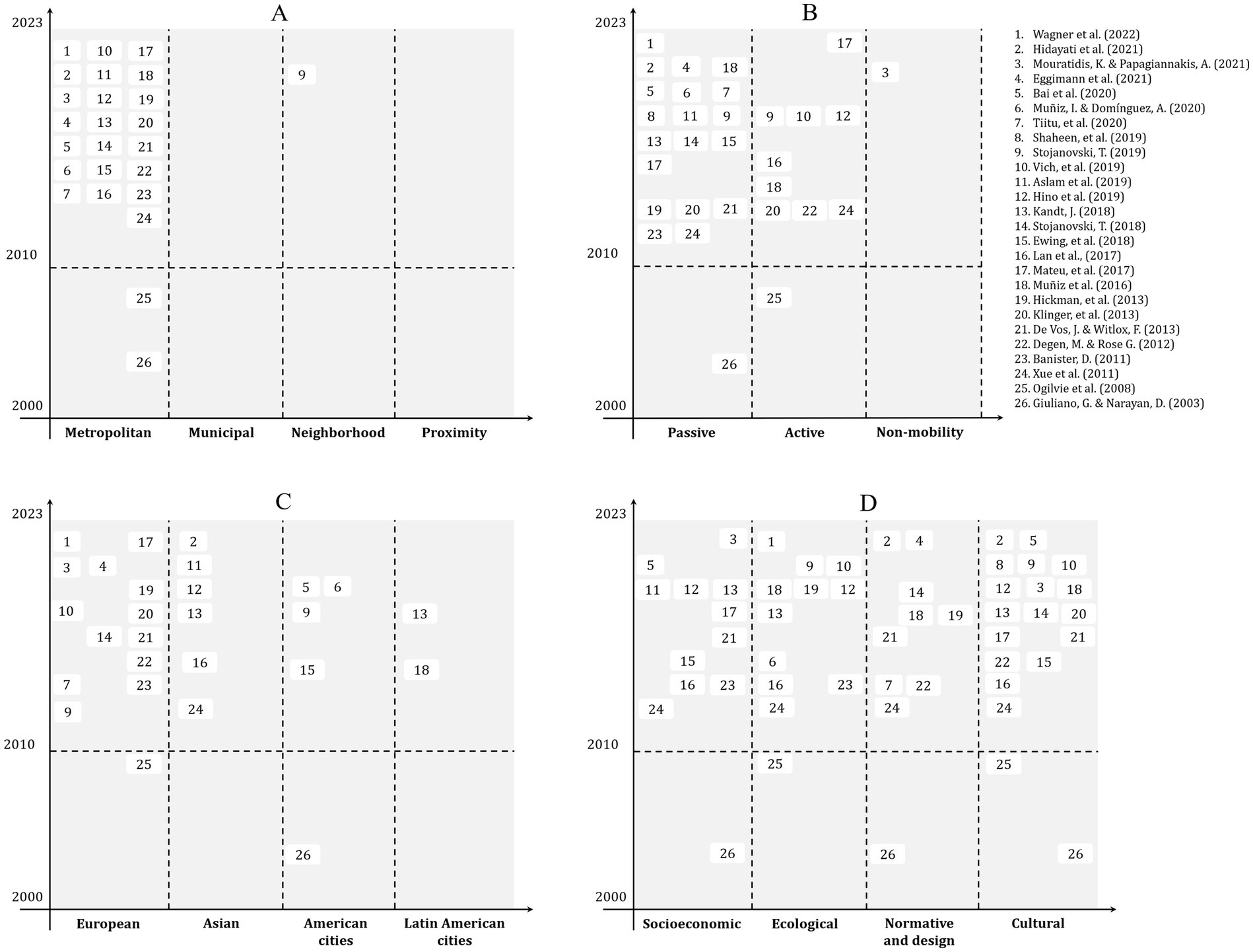
Figure 1. Classification of the most cited articles on urban form and sustainable daily mobility. Source: authors’ elaboration.
Our findings reveal that knowledge production on the subject has favored meso- and macro-scales (Aslam et al., 2019; Bai et al., 2021; De Vos and Witlox, 2013; Degen and Rose, 2012) with 96% of the approaches at the metropolitan and municipal scales compared to 4% of them at the neighborhood or proximity scale (see Figure 1A). Regarding the type of mobility, the analyzed literature (Eggimann et al., 2021; Ewing et al., 2018, Hickman et al., 2013; Hidayati et al., 2021; Kandt, 2018, Klinger et al., 2013) focuses on passive mobility (61.5%) and active (Hino et al., 2019; Lan et al., 2017, Mateu et al., 2017) modes (38.5%), while only 4% on non-performed trips, (Mouratidis and Papagiannakis, 2021) or non-mobility (Figure 1B). Regarding case studies, most are made up of European (Ogilvie et al., 2008), Asian, and American (Muñiz and Domínguez, 2020) cities, representing 54, 23, and 15%, respectively, compared to 8% of studies (Muñiz et al., 2016) for Latin American cities (Figure 1C). The analyzed variables or dimensions show more balanced percentages, with 46% of the papers dealing with socioeconomic aspects, 46% with ecological issues (Vich et al., 2019; Xue et al., 2011), 73% with cultural characteristics (Shaheen et al., 2019; Stojanovski, 2018), and 38% with normative and design aspects (Tiitu et al., 2020) (Figure 1D).
1.1 Vitality, legibility, and active mobility in cities
According to Bentley et al. (1985), vibrant environments should be both physically and visually accessible and integrated into the city through routes with short distances and a layout configuration that allows more than one route to the same destination. In cities where railway infrastructures are evenly distributed, such a quality poses a great challenge. These elements not only divide public space but also create lifeless paths, turning them into non-places (Augé, 1993), prone to insecurity. Additionally, the authors state that a mix of land uses and varied architectural styles allow the creation of meanings, (Lynch, 1959), a criterion that opposes the dominance of residential urban developments with identical or similar row houses and industrial parks concentrated in certain areas.
Our literature review reveals that the approaches to the relationship between urban form and daily mobility mostly stem from the dominant paradigm, which supports the idea of a compact and diverse city as ideal for promoting active mobility. Most studies, however, only examine how the city’s morphological variables can influence the increase or reduction of some modes of public transport or car use, with limited contributions regarding the micro-scale urban form aspects and the design of the interface between public and private space. Therefore, this paper hypothesizes that urban form aspects at such a scale play a fundamental role in mobility practices, resulting in specific interactions in every context according to each socioeconomic profile. Specifically, this work seeks to demonstrate that desirable fine-grained urban design characteristics have great potential for active mobility routes, whereas unsustainable urban forms hinder such routes by creating insecurity, socio-spatial segregation, lack of comfort, and vulnerability to climate change impacts (e.g., heatwaves), conditions reflected in the social representation of the inhabitants of each polygon.
2 Methodology
This research presents a case study perspective aimed at providing insights from the Global South to foster a more inclusive and equitable debate on urban form design in relation to sustainable daily mobility. In this regard, the lessons learned could be useful for other cities in the same region that share similar characteristics and developmental processes. While the term “Global South” refers to countries that, regardless of their geographic location, share similar social, economic, and political conditions, including limited capacities and structural challenges to address social inequalities, the city of Monterrey behaves in some ways differently. From a cultural perspective, perhaps due to its proximity to the United States, Monterrey has more strongly embraced than other Mexican cities the idea of well-being associated with suburban housing, with the automobile as the ideal form of mobility. At the territorial level, Monterrey presents an urban development rate that surpasses that of Mexico City and Guadalajara. Its population is characterized by relatively high purchasing power and low levels of marginalization, all factors that contribute to a favorable profile in terms of economic inequality when compared with the rest of the country. Furthermore, over the last 20 years, this city has shown a sustained increase in both its vehicle fleet and GHG and particulate emissions. These aspects position the region as an area of substantial economic potential but also of significant environmental impacts where there are also significant socioeconomic contrasts and marked socio-spatial differentiation. Consequently, Monterrey and its mobility patterns represent an atypical combination of features, making it especially challenging and requiring more in-depth knowledge and understanding.
A “critical case” can be defined as one of strategic importance in relation to the overall problem (Flyvbjerg, 2006). To assess how micro-scale urban form influences sustainable mobility, it is useful to select two contrasting typological cases studies that have, in general terms, been replicated in other Mexican cities as well as in cities in other countries of the Global South. In this study, the critical cases consist, on one hand, of a residential area whose surroundings largely support active mobility, and on the other, an area that meets these conditions to a lesser extent. Therefore, if SUFi yields certain results in these two cases, such findings may also shed light on mobility patterns in other urban contexts with similar typologies.
As already mentioned, there were two major periods in the urbanization of modern Mexico: the Mexican miracle (1940–1970), so named for the unprecedented magnitude of economic progress, driven by the state as the main driver; and the neoliberal era (1982–2018), linked to market strategies seeking to rescue the country from the crisis following the decline of the import substitution model in the 1980s. Following import substitution, the accelerated rural–urban migration led to a housing crisis (Miranda, 2014), which was addressed by State institutions empowered to mass-produce housing. The projects created for this purpose adopted the criteria that were hegemonic on a global scale at the time, specifically those emanating from the so-called International Modern Architecture Movement (Sánchez, 2012).
Although this movement proposed the separation of land uses into vertical housing blocks, its incursion into social housing projects in Mexico did not occur as such. Instead, it opted to promote building density while incorporating a mix of other land uses, such as commercial, educational, and recreational. This currently represents areas that, due to their population density, are more viable for the installation of public transport lines and active mobility. In Monterrey, this housing boom began around 1960, at a time when other residential buildings with these characteristics did not yet exist, as the suburban housing culture predominated, with townhouses offering a quiet, safe place with a family atmosphere. It could be said that this region of the country was influenced from that moment on by both cultures, but with greater emphasis on the latter, thus generating expansive and unsustainable urban development, which has been accompanied by high-speed urban highways.
On the other hand, starting in 1982, policies such as the elimination of public housing subsidies, housing deregulation, and the reduction of the state’s regulatory role allowed a major involvement of the private sector. Constitutional amendments enabled the privatization of communal lands, making them available to the real estate market as low-cost development sites. This deregulation led to various unsustainability challenges due to factors such as the inefficient use of urban land and resources. As a result, housing developments far from urban centers became the norm, creating a reliance on private vehicles due to limited access and deficient public transport service available, which primarily served inner-city residents.
Monterrey, viewed as the quintessential Mexican industrial capital, has been associated with an image of an aggressive, dirty, and polluted city (Prieto, 2014). It has also historically stood out for its ideology of “progress” associated with the development of modern urbanism and architecture. According to Prieto (2014), various political changes in this region around 1914 laid the foundation for a shift in the appreciation of the most emblematic buildings inherited from a colonial past (such as churches and commercial buildings). This limited interest in valuing architectural heritage also implied a social ideology of modernity, which later contributed to the deterioration of residential complexes such as Condominios Constitución, in favor of the rise of developments located on the outskirts like La Alianza. This can be interpreted as one of the reasons for the limited success of the so-called modern movement in this city.
Monterrey’s urbanization process has been characterized by a clear separation of land uses (single use) and low density, the latter especially reinforced by low-density residential development (by 2015, 96% of housing was single-family and 2% was vertical housing; INEGI, 2015). This expansion has resulted in Structured Public Transport (TPE) being accessible just by 14% of homes, while only 11% of them have proximity to workplaces. The polygons analyzed – see further details below – correspond to two different areas of the city: the center and the periphery of Monterrey.
The Monterrey metro system, which began operating in 1991, has 3 lines that influence four of the 14 municipalities in its Metropolitan Area. Bus units generally travel alongside cars, often exceeding their maximum capacities, leading to delays and limitations in service, safety, and user satisfaction. By 2014, the first bus rapid transit (BRT) line was inaugurated, complementing the services of the aforementioned system. The distribution of public transport within the urban area has been and remains unequal, leaving most of it without access. This situation has been addressed through densification in areas adjacent to public transport but has not yet resulted in significant transformations.
2.1 Selection of case studies
Based on the above, the selection of cases addresses the need to develop solutions for the developments produced in each of the periods outlined.
“La alianza” Proximity Polygon is located about 15 km northwest of the city, on the outskirts of the municipality of Monterrey (Figure 2), “La Alianza” is a low-density neighborhood highly dependent on automobiles, characterized by the separation of land uses and lack of proximity to metro routes. It has access to the “Ecovía” (this is the only Bus Rapid Transit route that crosses the city from east to west) on the Av. Abraham Lincoln and two bus routes with irregular schedules and inconsistent stops, with a service radius of 3.5 km. Elevated pedestrian crossings, which are difficult to access, are found on the main roads of this area, while the numerous vacant lots create routes prone to insecurity.
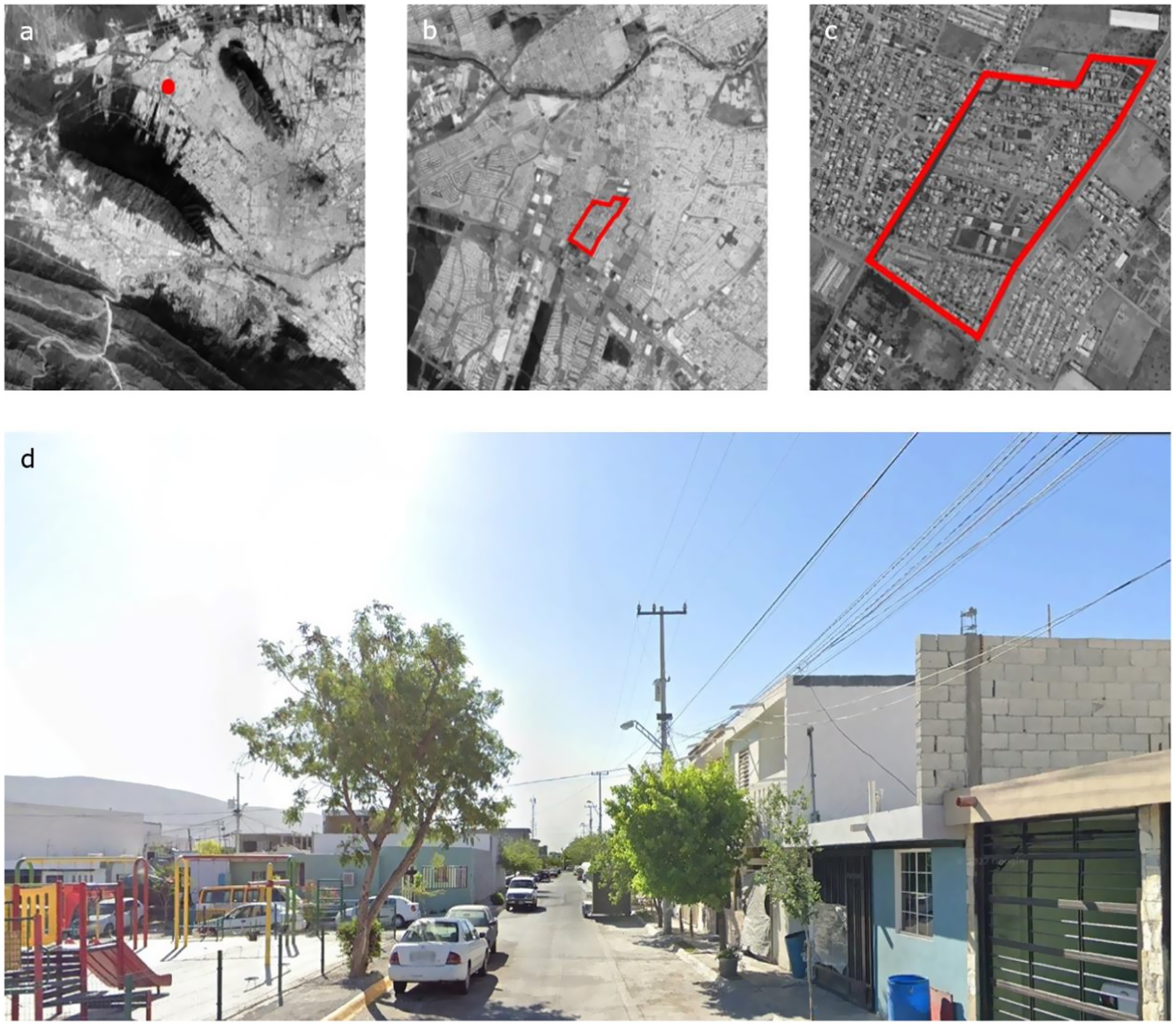
Figure 2. Peripherial borough: La Alianza. 25 km × 25 km (a), 5 km × 5 km (b), 1 km × 1 km (c), street view (d). Source: Google Earth images with authors’ annotations.
Proximity Polygon “Condominios Constitución” is located adjacent to the historic center of Monterrey (Figure 3), this is a model of functionalist collective housing, medium-density, and low-cost, designed in 1964, which also pioneered the promotion of condominium housing culture. Its urban form is notable for its compact and dense volumes with a rationalist appearance. It is a neighborhood with good urban quality for walkability as it has a mix of uses and proximity to all amenities. From the condominiums, two of the three metro lines can be accessed within a maximum of 8 min, along with 5 bus routes that run along the perimeter of the neighborhood.
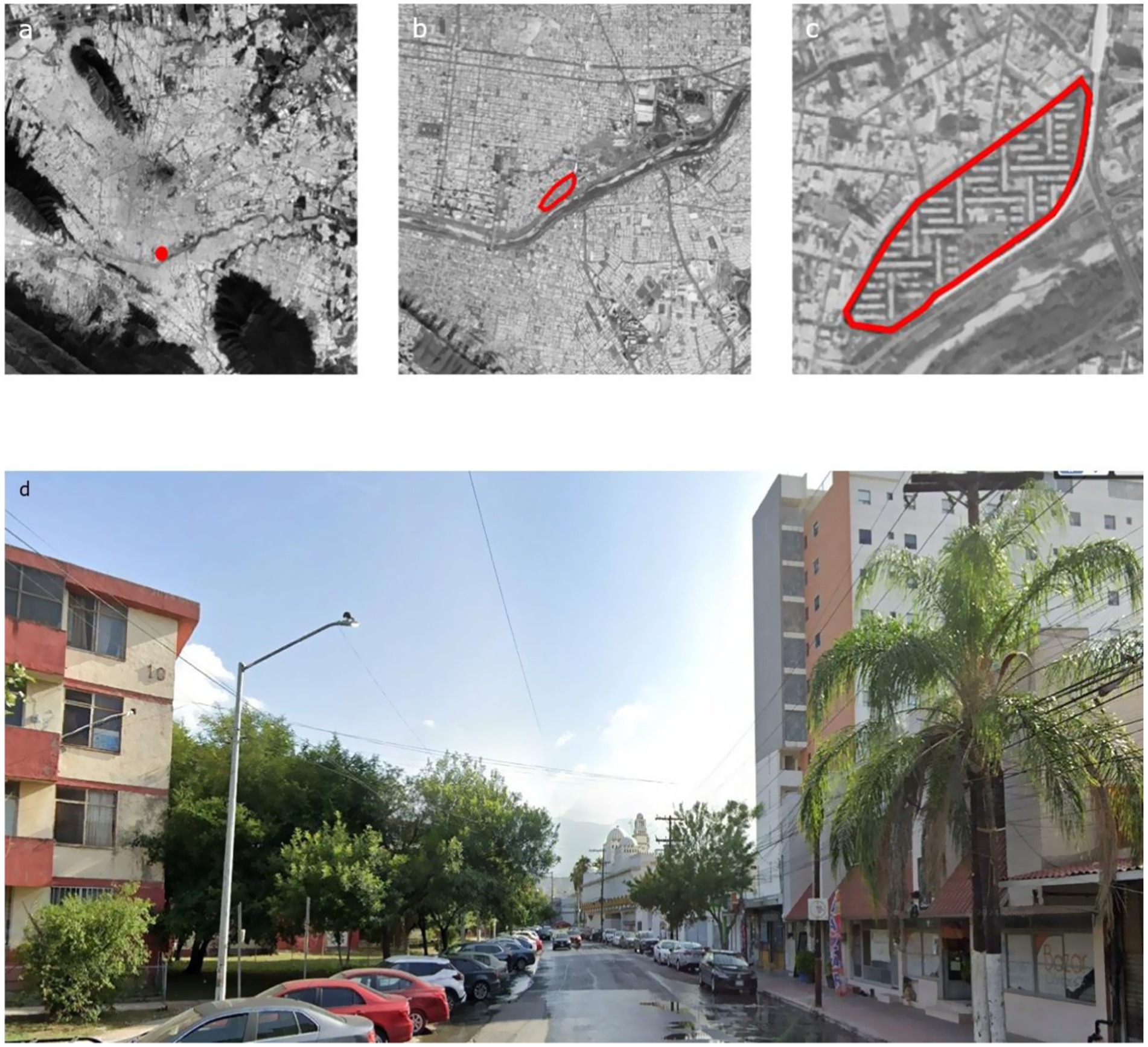
Figure 3. Downtown borough: Condominios Constitución. 25 km × 25 km (a), 5 km × 5 km (b), 1 km × 1 km (c), street view (d). Source: Google Earth images with authors’ annotations.
Regarding economic income, surveys showed a higher profile for Condominios Constitución, with the majority group represented by 38% of its resident population earning between 6,000 and 10,000 pesos, while in La Alianza, 46% reported having incomes between 0 and 3,000 pesos (Figure 4). It is worth mentioning that for the year 2020 the minimum wage was $3,784 pesos per month (or about US$200 dollars).
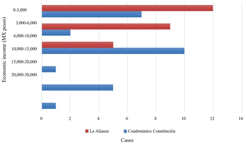
Figure 4. Average population income of selected polygons. Source: authors’ elaboration based on surveys.
2.2 Method for the construction of SUFi
The definition of the TOD model, according to City and County of Denver (2006), states that, in addition to being an urban development model close to the TP, a TOD must be capable of creating pleasant, vibrant, walkable neighborhoods, with accessibility to shops, housing, and services through different means of transportation. In contexts of the Global South, and in the case of Mexico, this purpose faces different challenges linked to the history of its urban planning and city management. Most large Mexican cities are primarily the result of industrialization processes that were outpaced by accelerated population growth and lack of economic maturity. This mismatch fostered the emergence of informal economies, poverty, invasion of public space, the proliferation of gated communities, and socio-spatial segregation (Almandoz, 2008), all of which contribute to conditions conducive to the transgression of human rights and the right to the city.
The SUFi proposal emphasizes the relevance of addressing aspects of urban form that have historically been overlooked in urban planning in order to achieve the objective of the model on which it is based. Given that aspects such as natural surveillance and the vitality of public space depend on architectural design, our set of indicators is introduced at this scale to complement the broader TOD criteria validated elsewhere. This approach allows us to offer a more tailored solution to the complexities that characterize urban planning in Mexico, specifically addressing the conditions faced by pedestrians and cyclists in this context.
The research instruments include the application of surveys, non-participant direct observation, photographs, and urban cartography to collect data on daily mobility practices, morphological characteristics, and their degree of sustainability to determine their relationship. The study selects a non-probabilistic sample in which a total of 25 individuals over 18 years old were surveyed, contacted through the “snowball” sampling method. Initially, a significant portion of these surveys focused on social representations, a dimension of analysis that sought to obtain the greatest amount of information possible. This method offers advantages: as participants recommended others with shared experiences related to the topic, the resulting information allows for a deeper and more robust understanding of the phenomenon. Given the exploratory nature of the study and the use of non-probabilistic sampling method, this approach was considered appropriate. The intent is to conduct an exploratory study that could later be refined and expanded into a more representative study using additional data collection and processing methods.
For the qualitative part of the study of social representations associated with daily mobility, the hierarchical evocation method was used, whose objective is to find the elements of the central core and its peripheries (Abric, 2003). This method is carried out in two parts: the first involves free associations, using a word that induces the respondent to mention another that evokes the previously mentioned word. In the second part, respondents are asked to mention the same words in order of importance; this part is called ranking. The analysis of the described technique concentrates the collected words in a table, which is divided into four boxes: the core area, where the most frequent and important words appear; the first periphery box contains elements that appear frequently but are of low importance; the third box contains those that present low frequency but are of great importance, called contrasting elements; and the last box, a second periphery, contains words whose frequency of appearance and importance were low.
To evaluate and monitor the sustainability of urban form, the proposed set of indicators focuses on 10 thematic axes (Figure 5), from which 34 indicators are derived. For determining the weight of each theme based on its contribution to the walkability of public spaces, a two-step methodology was applied. First, experts completed an Analytic Hierarchy Process matrix. Then, a standard weighted sum multicriteria method was used. This method, developed by Thomas Saaty between 1971 and 1975 (Saaty, 1980), relies on pairwise comparison elements, assigning importance according to specific objectives. It establishes the relative importance of each criterion in relation to the others, prioritizing elements through a hierarchical value system aligned with the main objective. The thresholds and the measurement scales in Table 1 (see further below) emanate from the matrices completed by the participating experts (Table 2). These items measure design qualities with the support of databases and cartography (Figures 6, 7), aiming to provide an understanding from an “immaterial” point of view about certain aspects of urban form that contributes to active mobility by creating a sense of place.

Figure 5. Themes and indicators of the Urban Sustainable Form Index. Source: authors’ elaboration based on specialized literature.
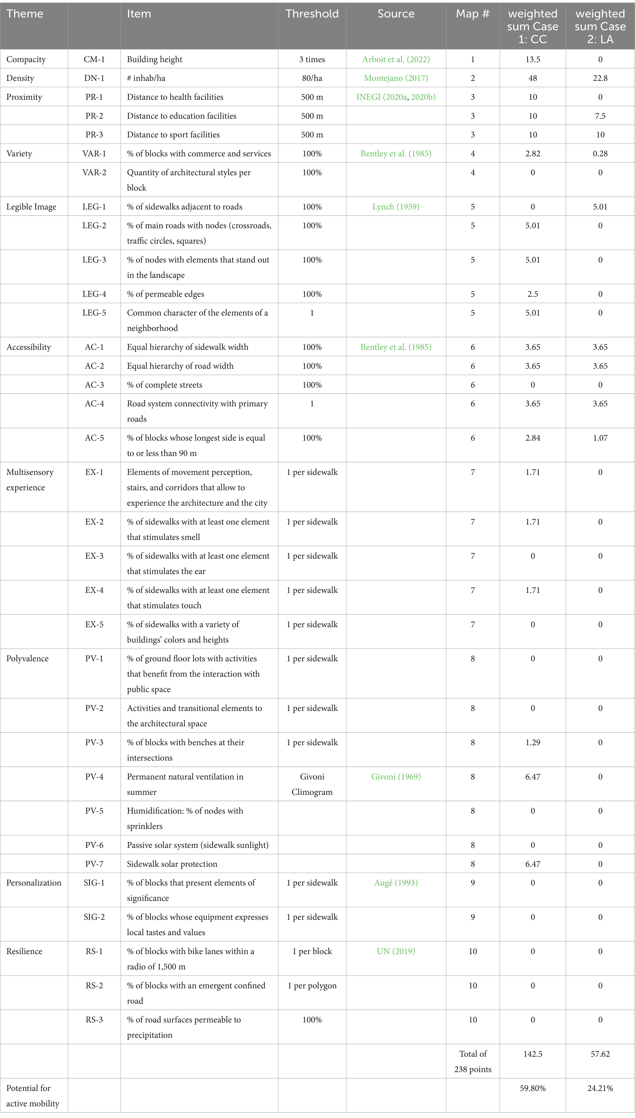
Table 1. Evaluation of sustainable urban form for the selected case study polygons.
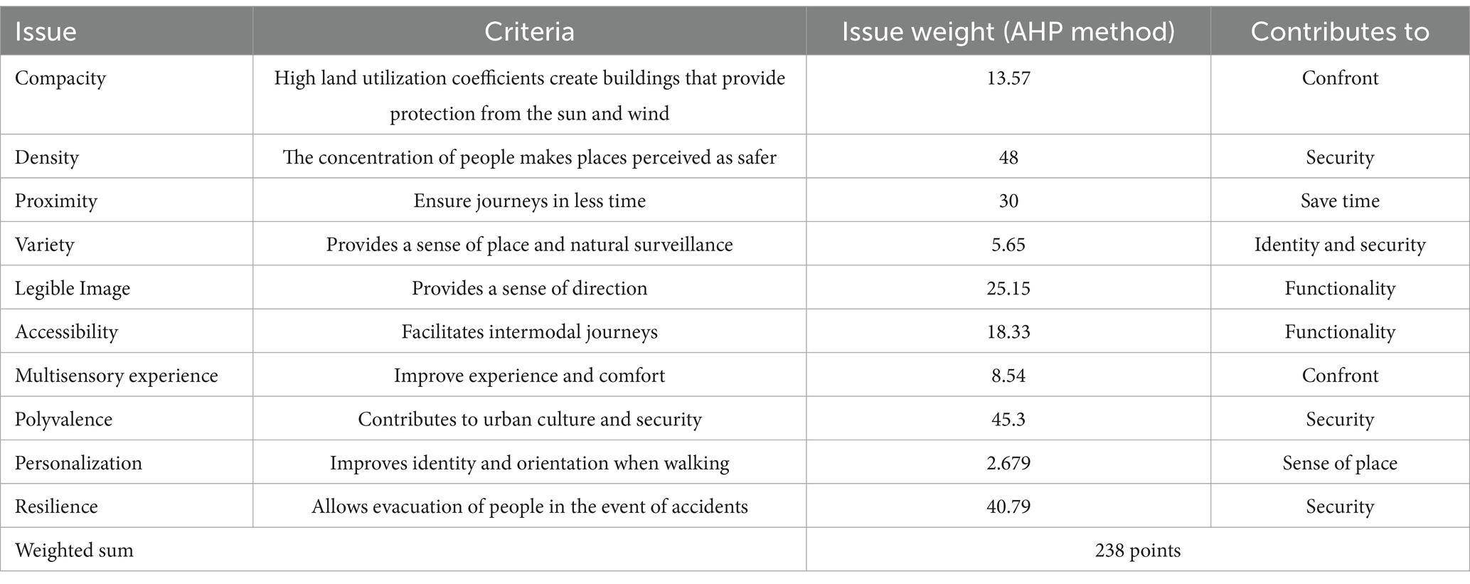
Table 2. Analytic hierarchy process matrix weights and attributes.
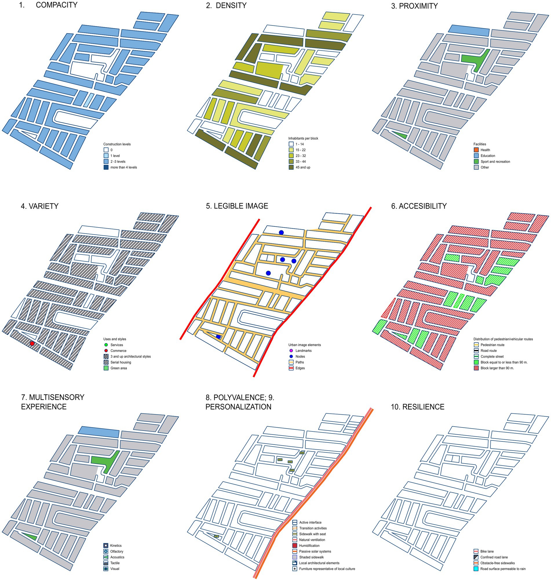
Figure 6. Thematic maps of the polygon: La Alianza. Source: Authors’ elaboration based National Statistical Directory of Economic Units (DENUE) and Google Earth data.
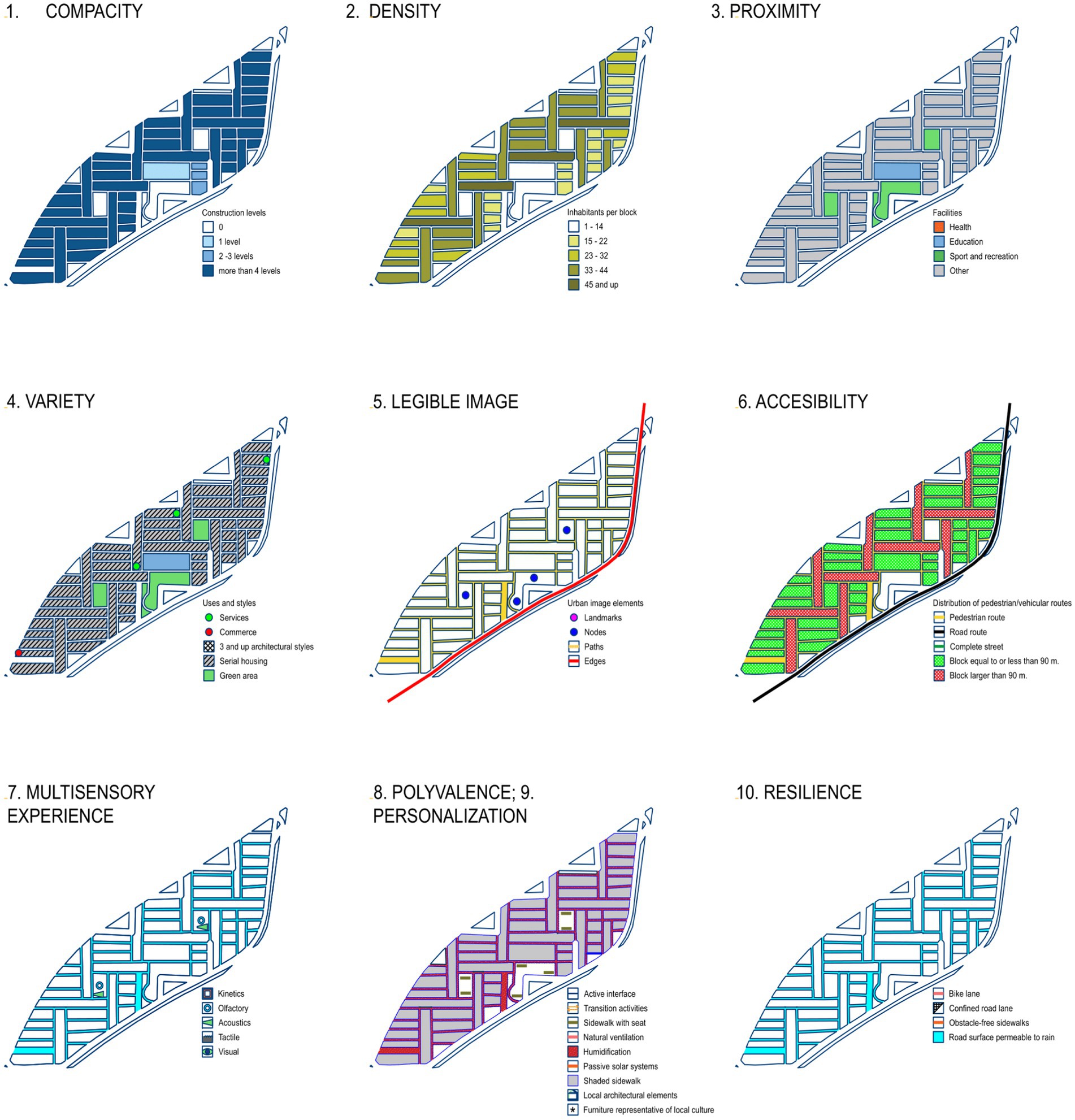
Figure 7. Thematic maps of the polygon: Condominios Constitución. Source: authors’ elaboration based National Statistical Directory of Economic Units (DENUE) and Google Earth data.
2.2.1 Architectural scale
This consists of the composition and design of public and private buildings. The morphology of the lots that make up each neighborhood depends on land use coefficients, levels of usage, percentage of free area, as well as the facade design as a transition element towards the public space where minimum habitability conditions for thermal and spatial comfort must be provided to encourage active pathways.
2.2.2 Compacity and density
The number of floor levels on each lot will vary in each case; the optimal number will be based on the needs for sunlight and/or shading given the climatic characteristics and the effects of the “heat island” phenomenon. The indicators express the relationship between building height and optimal street width to allow sunlight in winter.
2.2.3 Proximity
The arrangement of services and commerce is decisive in the choice to walk. In this sense, the literature shows some agreement with the notion of a walkable city around distances that can be covered in 10 min. Distances for which Talen and Koschinsky (2013) project an average speed of 1.4 m/s, thus covering a distance of 800 m in 10 min. The proposed indicators are measured considering this criterion with the mapping of proximity of facilities to support the measurement of the indicators, which verify the existence of buildings designated for public health, basic education, recreation and sports.
Although other factors, such as the presence of convenience stores, also contribute to motivating active travel on a proximity scale, this study is limited to analyzing the mentioned services due to the lack of standardized data on the location of these establishments and their main characteristics.
2.2.4 Variety
At the block level, it involves different forms, land uses, and meanings, so that a certain degree of vitality is achieved through daily activities and social interaction of different social groups. According to Bentley et al. (1985), environments with this quality offer more choices to the population. This quality would, in turn, be affected by the size of lots, in blocks formed by large lots that have been planned with percentages above the rest or have been merged. Two indicators are proposed to measure the existence of commercial and service uses, and the number of architectural styles per block, respectively.
2.2.5 Personalization
The identification of places and their uses are provided by the uniqueness of their elements within a visual syntax of urban image. At an urban scale, it is important to avoid the homogenization of space, as this weakens human experience and erases the sense of place (Augé, 1993). In turn, buildings communicate their particularity through materials, surfaces, colors, styles, and other components that together communicate the identity of the locality to which they belong.
2.2.6 Medium scale (public space)
Referring to the configuration of urban fabric. The morphology of the lots that make up each neighborhood depends on the layout of the surrounding routes to generate connections, accessibility, and corridors with greater relevance in a hierarchy of uses. Therefore, the management of elements that provide urban legibility must be based on the geometry of the blocks, an element that influences the determination of street dimensions.
2.2.7 Legible image
The image of the city is constituted by those elements that are hegemonic social representations. According to Lynch (1959), these elements are landmarks, nodes, paths, edges, and neighborhoods or districts. Consequently, for a legible image it is necessary to ensure the existence of the above-mentioned elements in a strategic and functional manner. Landmarks serve as orientation points by standing out in the urban space, while nodes are social gathering places or meeting points, paths function as connectors between nodes, edges delimit different zones of the city (residential, commercial, industrial, etc.), and neighborhoods or districts denote groupings of elements with similar characteristics within a polygon.
2.2.8 Accessibility
Aims to make places accessible through the design of block shapes and their interface, given the role they play as transition spaces between public and private. The elements identified by Bentley et al. (1985) as decisive for achieving this quality include the non-hierarchical nature of pedestrian, vehicular, cyclist, and/or public transport networks; the non-segregation of public space; and the generation of active interfaces for a correct transition between the public and the private. The permeability indicators used are: Equal Hierarchy of Sidewalk Width; Equal Hierarchy of Road Width; Percentage of Complete Streets; Connection of Road System to Main Roads; Percentage of Blocks with Longest Side Equal to or Less Than 90 m.
2.2.9 Multisensory experience
Despite the strong visual culture that prevails in contemporary society (Pallasmaa, 2010), the nature of the senses in the perception of architecture and the city requires multisensory design. Therefore, the creation of routes that include physical or visual movement through the kinetic, the olfactory and acoustic experience provided by landscape elements, or the placement of surfaces that stimulate touch, defines the richness conditions that will make public space more walkable.
2.2.10 Polyvalence
The non-specialization of land uses, inherent to the social character of public space, entails the capacity to host different uses to increase experiences of economic and social exchange. Among the biophysical conditions to achieve multiple functions are the uses of ground floor lots, the elements that generate transitions between public and private, urban furniture, active interface, and microclimate. In this regard, monitoring the mentioned indicators allows managing economically active, participatory, and comfortable facades. The Polivalency Indicators of the Index use Givoni’s (1969) climograph model as a tool for measuring hygrothermal comfort. This model concentrates the variables of maximum and minimum temperatures and humidity per month to determine the active and passive climatization strategies according to the corresponding latitude.
2.2.11 Resilience
The capacity of urban systems to anticipate or overcome disturbances, such as climate and environmental related impacts (or “externalities”), in a timely and efficient manner –while ensuring the adaptation, improvement, and transformation of essential structures and functions towards more inclusive and increasingly fair modalities–, presents significant challenges for designing applicable policies at the micro-scale. Some impacts may be exacerbated due to the inadequate preparation of cities to evacuate a group of the population or to rehabilitate or even redesign an urban area after a similar crisis. Among the characteristics that infrastructures should consider as part of a resilient mobility system are: pedestrian and cyclist circuits; the permeability of vehicular lanes; the segregation of emerging routes and their connection to local roads, among other issues that enable uninterrupted active and emergency mobilities in the face of natural disasters.
3 Applying the USFi
In terms of urban sustainability, Monterrey’s urban quality conditions can be understood through a futuristic-stridentist imaginary (Prieto, 2014), which rejects the idea of a historical city, including the modern movement era. Instead, characteristics like speed and grandeur manifest a sort of modern city heavily dependent on automobiles, suburban housing, and intense material and energy consumption, with 4.2% of the national population, the metropolitan area of Monterrey accounted for 5.1% of the total urban demand for resources in 2022 (Delgado et al., 2023). At the level of urbanity, factors like walkability, microclimate, or urban image become less important compared to historical cores or city centers, which will gradually lose their role as social spaces, shifting towards consumption-mediated spaces like shopping centers under neoliberal urbanism influences.
In 1964, the construction of the Condominios Constitución residential complex on a site adjacent to the historic center marked the beginning of the modern era with a strong aesthetic language influenced by European functionalist roots. This urban development features resource-efficient characteristics such as compactness, density, and microclimate design. The “Condominios Constitución” proximity polygon consists of 51 regularly plotted blocks oriented north–south and east–west, covering an area of 9.52 ha. In contrast, the “La Alianza” case comprises 24 irregularly plotted blocks with various orientations. Using data from Google Earth, INEGI (2020a, 2020b), and thresholds established by specialized literature, the necessary cartography was developed to estimate 34 urban form indicators (see Table 1).
4 Findings
The results of the SUFi application in Condominios Constitución show an overall score of 59.80% potential for active mobility (Figure 8), indicating positive outcomes with significant areas for improvements, especially in personalization and resilience indicators, followed by polyvalence, accessibility, and legible image indicators, where certain criteria are met but others are lacking.
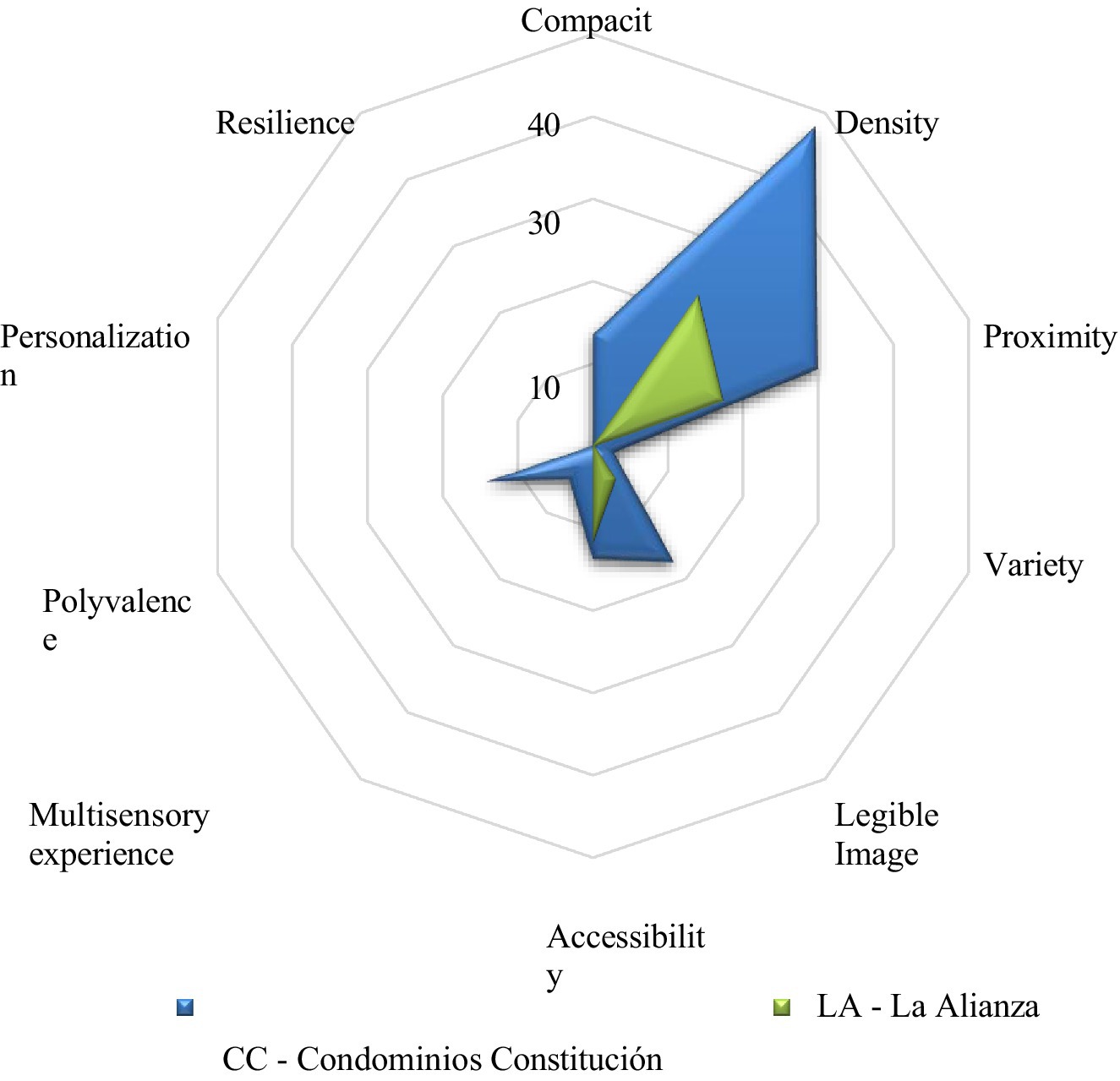
Figure 8. Comparative sustainable Urban Form Index results of case studies. Source: authors’ elaboration based on the application of the index.
For “La Alianza,” the results reveal a 24.21% potential for active mobility, positioning them negatively, as only 6 of the 34 indicators scored well, with compactness, multisensory experience, polyvalence, personalization, and resilience scoring zero. In contrast, the urban form design of “Condominios Constitución” shows higher potential for active mobility, meeting acceptable levels of compactness, proximity, and density, as well as elements that offer a legible image and good accessibility management.
4.1 SUFi and urban mobility practices
The population of the selected polygons, for Condominios Constitución, includes the complete Basic Geo-Statistical Area (AGEB) 1903900012453, with a total population of 2,219 inhabitants (INEGI, 2020a, 2020b). Of this population, 1,908 people (86%) aged 18 and over formed the total population considered as potential respondents.
In the case of La Alianza, parts of AGEB 1903900015068, 1903900015049, and 1903900015015 total a population of 3,639 inhabitants (INEGI, 2020a, 2020b). Of this population, 2,365 people (65%) aged 18 and over formed the total population considered as potential respondents. A non-probabilistic sample of 25 individuals aged 18 and over from each polygon was surveyed using the “snowball” sampling method, where initial respondents suggested more participants deemed important for the study.
4.2 Case CC
The sample population consists of 32% originating from the Metropolitan Area o Monterrey (MAM) and a majority of 68% from other federal entities. Age groups were divided into 12% aged 19–25, 48% aged 26–35, 12% aged 36–55, and 36% aged 56 and over. Occupations were divided into 48% homemakers, 24% students and retirees, 28% salaried workers, and 4% professionals. Educational attainment was 36% bachelor’s degree, 32% secondary education, 28% high school, and 4% primary education. Income ranged from 3,000 to 6,000 pesos for 8%, 3,000 to 10,000 pesos for 40%, 0–3,000 pesos for 28%, 10,000 to 20,000 pesos for 20%, and 10,000 to 15,000 pesos for 4%. In the Constitución Condominiums the dominant income range was $6,000–$10,000, followed by $15,000–$20,000, and another group whose income was in the $0–$3,000 range.
4.3 Case LA
The sample population consists of 64% originating from the MAM and 36% from other federal entities. Age groups were divided into 24% aged 19–25, 16% aged 26–35, 48% aged 36–55, and 12% aged 56 and over. Occupations were divided into 56% homemakers, 16% students and retirees, 16% traders, and 4% professionals. Educational attainment was 64% secondary education, 16% university, 12% high school, and 4% primary education. In this case the dominant income range was $0–$3,000, followed by $3,000–$6,000, and then a smaller group of $6,000–$10,000.
After gathering socioeconomic data, mobility patterns were established by asking how often respondents traveled by car, carpool, bus, metro, bicycle, and on foot per week, yielding the total number of weekly trips (Figure 9). “La Alianza” recorded the highest mobility with 477 trips, predominantly using public transport (49%), followed by walking (35%), car use (10%), bicycle (6%), and carpooling (5%). In “Condominios Constitución,” respondents reported 273 trips, with 37% on foot, 23% by public transport, 27% by car, 10% carpooling, and 3% by bicycle.
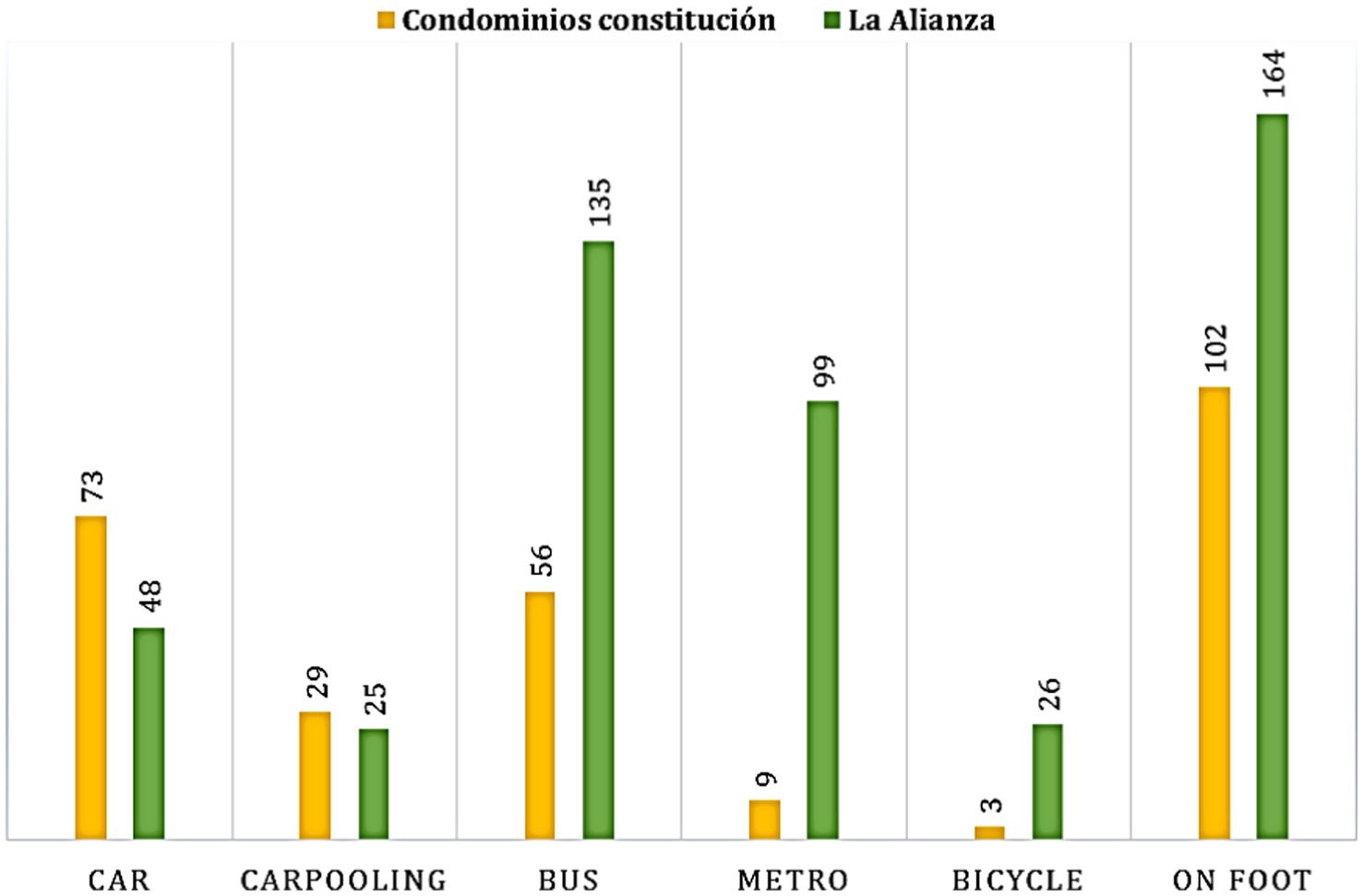
Figure 9. Mobility practices in case studies. Source: authors’ elaboration based on survey information.
4.4 Social representations as active mobility potential
The human need for cognition, understanding, and valuation of the world means ideas are constantly reshaped through processes of re-signification. New information from voices, customs, and actors within a culture integrates with existing knowledge, forming greater frameworks to guide practices. Actions occur within the spatiality of the urban or architectural environment, providing experiences that shape an imaginary fueling social representations, often projecting aspirations and ideals. For Fried (1966), spatial identity is crucial for human functioning, based on memories and spatial images.
Mobility, as a multifactorial phenomenon, is also conditioned by its social and cultural context. The intangible component, comprised of ideologies, worldviews, stereotypes, opinions, even emotions, sometimes plays a predominant role in modal choice. This requires critical analysis to determine whether the representations associated with groups such as pedestrians and cyclists are positive or instead influenced and shaped by idealized conceptions of lifestyles that may not contribute to sustainability. Another useful aspect of this dimension lies in its capacity to reveal inconsistencies between representations and actual practices, thereby highlighting underlying processes of contestation. Such insights are specially valuable for socio-environmental communication and education as they can foster the emergence of new hegemonic representations that support and accelerate sustainable behaviors.
Mobility experiences can drastically change based on the ability of public spaces to evoke feelings (e.g., tranquility, safety, belonging, appropriation, happiness) and enable states of mind within them. The sense of place involves interpreting the location. The hierarchical evocations in this paper address how the collective constructions around everyday mobility components, particularly urban form aspects and perceptions of active travelers, may or may not relate to modal choice (Table 3).
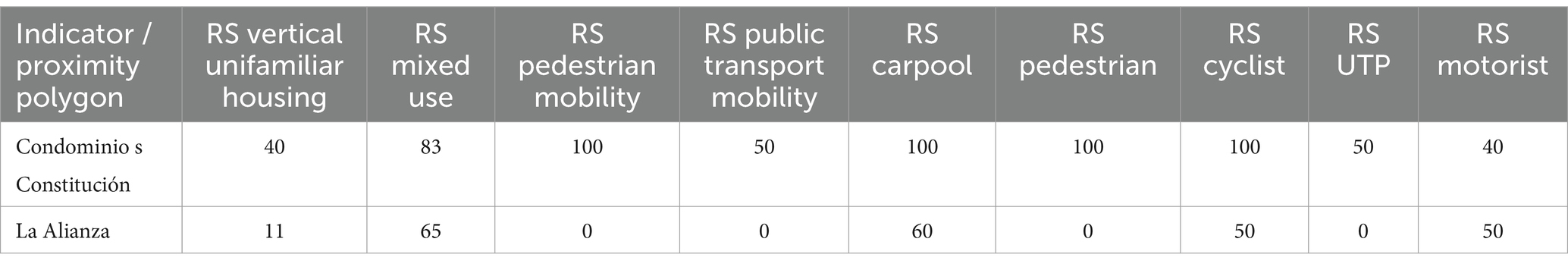
Table 3. Social representation of urban form and everyday mobility in case studies.
Given the aforementioned aspects, understanding the characteristics of the notions of “urban vitality” and “non-places” provides the necessary elements to address:
• What implicit ideas in observed social representations contribute to the sense of place for everyday pedestrian and cyclist routes?
• How is the notion of sustainable mobility manifested in social representations?
• Is there a coherent and positive link between social representations and practices?
In the “Condominios Constitución” polygon, respondents prioritized public transport users, followed by pedestrians, motorists, and cyclists. In “La Alianza,” respondents prioritized public transport users, followed by pedestrians, motorists, and cyclists.
Condominios Constitución scored positively on five indicators: mixed-use land, carpool use, pedestrian, cyclist, and motorist. While representations favored pedestrians and cyclists (100%), respondents also favored car use (60%) and public transport (50%), indicating these modes are seen as suitable options. This suggests that indicators of proximity, legibility, accessibility, multisensory experience, and polyvalence at acceptable levels significantly influence their active mobility practices. These practices align with their main travel mode being walking (42.5%), car (30%), public transport (27%), and bicycle (1.25%).
La Alianza scored well on mixed-use land and carpool use. Results showed 50% positive representations for cyclists, but not for pedestrians and public transport users (0%). Despite not representing most elements of sustainability positively, their practices indicate prevalent public transport and walking (50%). Car use was 10%, though representation favored it by 50%, suggesting ideological influences that do not contribute to sustainability. With higher income, this population might opt for car use in daily trips.
An integral interpretation of results reveals a disconnect between the evaluation of proposed indicators, the dominant practices of active mobility, and the social representations associated with its components and actors. This could be understood from the socioeconomic characteristics of each case. In La Alianza neighborhood the group of people over 56 years old (who may have greater difficulties in active mobility) is 12%, while in the Constitución Condominiums this group is 36%. In addition, another key factor that could explain why there is less active mobility in CC is the economic income of this group, while in LA almost half of the respondents have incomes below the minimum wage, in CC only 4% of respondents are in this income range. This implies that there are greater possibilities of owning a private vehicle in this group. The above corroborates that mobility is a multifactorial and multiscalar phenomenon that must be carefully managed, considering all related biophysical, socioeconomic and cultural factors.
5 Conclusion
The presented index offers a particularly necessary perspective in the study of urban form and morphology. At the micro-scale of proximity, it is possible to incorporate fine-grained urban design aspects related to the interface between architecture and public space, which have so far been largely overlooked in current urban design regulations, as they are often regarded as theoretical without binding power for practical application. The concepts of urban vitality, urban image, and urban resilience effectively operationalizes the necessary criteria to address both the externalities generated by TOD models in Latin America and the need for creating walkable, sustainable, and resilient spaces in a broad sense. This understanding stems from the fact that walking, beyond merely covering the distance between two points, is a social act that depends on the identity, sense of place, and sense of belonging fostered by architectural and urban design.
According to Koolhaas (2006), contemporary cities face a lack of identity. The accelerated pace of urban population growth has created a disconnect between function, form, meaning, prioritizing the first two with the support of the rise of the motorized city, which inherently fosters and entrenches unequal urban development. For this reason, instilling public space with significance, with elements that tell the local history to prevent them from becoming empty spaces traversed only out of necessity, is a feasible task if both the material potential—analyzed here—and the imaginaries expressed in social representations are considered.
Creating identity requires gathering and concentrating elements. However, the principles upheld by peripheral urbanization, increasingly manifest since the onset of the neoliberal era, focus more on meeting material or functional needs from an individualistic perspective (which in turn depends on individuals’ purchase-capacity). The idea of meeting a need for shelter is achieved while simultaneously suppressing everything that generates attachment. These areas, like the case study of “La Alianza,” sometimes serve as “dormitory cities” or “sacrifice zones” where urban memory is considered not relevant.
Our findings have provided a clear image of the morphological possibilities presented by each topic in the different cases (Figure 8), enabling the modification and management of aspects that could improve their potential for active mobility. In the case of the compact city represented by Condominios Constitución, its characteristics of compactness, density, proximity, and accessibility—related to mixed land uses—make managing the other topics (which have zero scores) more feasible in terms of time and cost, given their short- and medium-term nature. Conversely, for the diffuse city, illustrated by the case of La Alianza, the aforementioned criteria are not resolved in its form, making other aspects more challenging to modify in the short and medium term. This is because achieving a certain degree of compactness, for example, involves increasing the built levels per parcel, which is only possible through the design and construction of new buildings, requiring the modification of the building height in the applicable regulations and potentially compromising resource efficiency if vertical construction surpasses a certain number of levels. In the case of variety, architectural styles reflect a specific urban memory (constituted in the long term) and contribute to generating multisensory experiences according to the characteristics of their elements. Returning to the proposed hypothesis, it can be inferred that while fine-grained aspects of urban form play an important role in mobility practices, they are not the sole explanatory factor of such practices. Social and socioeconomic representational dimensions also provide elements that help us understand them. In this context, it becomes evident that urban form shaped during the neoliberal period pose considerable challenges and thus requires greater efforts to foster active mobility. This is due to changes related to land uses –including the location of residential uses–, the distribution of land use purposes, the accessibility to amenities (urban services, infrastructure, and urban equipment), the degree of urban compactness, and the loss of place identity with the increasingly frequent emergence of the generic city. Such transformations have negatively impacted everyday mobility practices, as the trend toward active mobility is declining. For this reason, and due to the non-probability sampling method used, the analyzed cases should be considered as indicative – serving as starting point for more robust future analyses. These should be interpreted holistically, considering the concepts they represent as a whole and by considering their interconnections, all with the aim of developing a replicable methodology. A conclusive study will therefore require a more comprehensive version supported by a larger and more representative sample.
Recognizing the inherent difficulty of operationalizing issues such as social interaction, personalization, public space configuration, and urban image, the refined and complete version of this report will need to incorporate a measurement instrument grounded on hierarchical word recall techniques, more detailed and robust opinion analysis, and the perceptions of public space users and residents of the analyzed urban polygons. The use of Information and Communication Technologies (ICTs) in this latter task would enable a more efficient data collection to inform the evaluation of indicators. Regarding the hypothesis posed, urban form aspects initially considered fundamental will be retained in future directions of this work, but other variables will need to be also incorporated, including socioeconomic issues like income and age, and cultural issues –like the social representation of mobility modes– due to their potential to explain dominant practices. In this sense, the study will also consider developing profiles based on socioeconomic and demographic characteristics supported by ethnographic techniques, which will help explain the complexity of everyday mobility practices. Furthermore, to ensure the achievement of the proposed indicators, it will be crucial to rethink the current policy model regarding territorial planning, and specifically lad use, not only to promote greater diversity of lad uses but also to enable regulatory criteria that are effective at the micro-scale.
Data availability statement
The original contributions presented in the study are included in the article/Supplementary material, further inquiries can be directed to the corresponding author.
Author contributions
LC: Writing – original draft, Conceptualization, Data curation, Formal analysis, Investigation, Methodology, Resources, Validation, Writing – review & editing. GD: Resources, Writing – review & editing, Formal analysis, Supervision.
Funding
The author(s) declare that no financial support was received for the research and/or publication of this article.
Conflict of interest
The authors declare that the research was conducted in the absence of any commercial or financial relationships that could be construed as a potential conflict of interest.
Generative AI statement
The authors declare that no Gen AI was used in the creation of this manuscript.
Publisher’s note
All claims expressed in this article are solely those of the authors and do not necessarily represent those of their affiliated organizations, or those of the publisher, the editors and the reviewers. Any product that may be evaluated in this article, or claim that may be made by its manufacturer, is not guaranteed or endorsed by the publisher.
Supplementary material
The Supplementary material for this article can be found online at: https://www.frontiersin.org/articles/10.3389/frsc.2025.1605835/full#supplementary-material
References
Abric, J. (2003). La recherche de la zone muette des représentations sociales en Abric, J. Méthodes d’étude des représentations sociales. Ramonville Sainte-Agne: Éditions érès, 59–80.
Almandoz, A. (2008). Despegues sin madurez. Urbanización, industrialización y desarrollo en la Latinoamérica del siglo XX. Rev. EURE 34, 61–76. doi: 10.4067/S0250-71612008000200004
Arboit, M., Maglione, D., and Otero, D. (2022). Determinación de variables edilicias presentes en morfologías del Área Metropolitana de Mendoza para la eficiencia energética. Rev. Urbanism. 47, 136–160. doi: 10.5354/0717-5051.2022.65608
Aslam, A., Masoumi, H., Naeem, N., and Ahmad, M. (2019). Residential location choices and the role of mobility, socioeconomics, and land use in Hafizabad, Pakistan. Urbani Izziv. 30, 115–128. doi: 10.5379/urbani-izziv-en-2019-30-01-004
Augé, M. (1993). Los “no lugares” Espacios del anonimato. Una antropología de la sobremodernidad. Barcelona, Spain: Gedisa Editorial.
Bai, S., Jiao, J., Chen, Y., and Guo, J. (2021). The relationship between E-scooter travels and daily leisure activities in Austin, Texas. Transp. Res. Part D Transp. Environ. 95:102844. doi: 10.1016/j.trd.2021.102844
Banister, D. (2011). Cities, mobility and climate change. J. Transp. Geogr. 19, 1538–1546. doi: 10.1016/j.jtrangeo.2011.03.009
Bentley, I., Alcock, A., Murrain, P., McGlynn, S., and Smith, G. (1985). Responsive environments: a manual for designers. Amsterdam: Architectural Press-Elsevier.
Bokhari, A., and Farahnaz, S. (2022). Public transport and subjective well-being in the just city: a scoping review. J. Transp. Health 25:101372. doi: 10.1016/j.jth.2022.101372
City and County of Denver (2006). Community planning and development, transit oriented development strategic plan. Available online at: https://cdn.flydenver.com/app/uploads/2023/09/14085251/disclosure2006-1.pdf
Conzen, M. (2009). How cities internalize their former urban fringes: a cross-cultural comparison. Urban Morphol. 13, 29–54. doi: 10.51347/jum.v13i1.3946
Dadashpoor, H., and Malekzadeh, N. (2020). Driving factors of formation, development, and change of spatial structure in metropolitan areas: a systematic review. J. Urban Manag. 9, 2226–5856. doi: 10.1016/j.jum.2020.06.005
De Vos, J., and Witlox, F. (2013). Transportation policy as spatial planning tool; reducing urban sprawl by increasing travel costs and clustering infrastructure and public transportation. J. Transp. Geogr. 33, 117–125. doi: 10.1016/j.jtrangeo.2013.09.014
Degen, M., and Rose, G. (2012). The sensory experiencing of urban design: the role of walking and perceptual memory. Urban Stud. 49, 3271–3287. doi: 10.1177/0042098012440463
Delgado, G., Jiménez, A., Vidal, D., and Castro, L. (2023). Urban political ecology in Mexico: metabolism, conflicts, and the need for transformational pathways in the valley of Mexico, Guadalajara and Monterrey. J. Polit. Ecol. 30, 716–742. doi: 10.2458/jpe.5221
Eggimann, S., Wagner, M., Na Ho, Y., Züger, M., Schneider, U., and Orehounig, K. (2021). Geospatial simulation of urban neighbourhood densification potentials. Sustain. Cities Soc. 72:103068. doi: 10.1016/j.scs.2021.103068
Ewing, R., Tian, G., and Lyons, T. (2018). Does compact development increase or reduce traffic congestion? Cities 72, 94–101. doi: 10.1016/j.cities.2017.08.010
Flyvbjerg, B. (2006). Five misunderstandings about case-study research. Qual. Inq. 12, 219–245. doi: 10.1177/1077800405284363
Fried, M. (1966). “Grieving for a lost home: psychological cost of relocation”. Massachusetts Institute of Technology, Cambridge, Massachusetts and London, England.
GHSL. (2020). Testing the degree of urbanization at the global level. Mexico – country summary. Copernicus. European Union. Available online at: https://human-settlement.emergency.copernicus.eu/documents/cfs01/V3/CFS_Mexico.pdf
Giuliano, G., and Narayan, D. (2003). Another look at travel patterns and urban form: the US and Great Britain. Urban Stud. 40, 2295–2312. doi: 10.1080/0042098032000123303
Guerra, E. (2014). Mexico City’s suburban land use and transit connection: the effects of the line B metro expansion. Transp. Policy 32, 105–114. doi: 10.1016/j.tranpol.2013.12.011
Hickman, R., Peter, H., and Banister, D. (2013). Planning more for sustainable mobility. J. Transp. Geogr. 33, 210–219. doi: 10.1016/j.jtrangeo.2013.07.004
Hidayati, I., Yamu, C., and Tan, W. (2021). You have to drive: impacts of planning policies on urban form and mobility behavior in Kuala Lumpur, Malaysia. J. Urban Manag. 10, 69–83. doi: 10.1016/j.jum.2020.12.004
Hillier, B. (2009). “Spatial sustainability in cities. Organic patterns and sustainable forms” in Proceedings of the 7th international space syntax symposium. Keynote 1. eds. D. Koch, L. Marcus, and J. Steen (Stockholm, Sweden: Royal Institute of Technology (KTH)).
Hino, K., Taniguchi, A., Hanazato, M., and Takagi, D. (2019). Modal shift from cars and promotion of walking by providing pedometers in Yokohama City, Japan. Int. J. Environ. Res. Public Health 16:2144. doi: 10.3390/ijerph16122144
Howell, N., and Booth, G. (2022). The weight of place: built environment correlates of obesity and diabetes. Endocr. Rev. 43, 966–983. doi: 10.1210/endrev/bnac005
INEGI (2020b). Volumen y Crecimiento. Población total según tamaño de localidad para cada entidad federativa. México: Ciudad de México.
Kandt, J. (2018). Heterogeneous links between urban form and mobility: a comparison of São Paulo, Istanbul and Mumbai. J. Transp. Land Use 11, 721–745. doi: 10.5198/jtlu.2018.1359
Klinger, T., Kenworthy, J., and Lanzendorf, M. (2013). Dimensions of urban mobility cultures – a comparison of German cities. J. Transp. Geogr. 31, 18–29. doi: 10.1016/j.jtrangeo.2013.05.002
Knowles, R., Ferbrache, F., and Nikitas, A. (2020). Transport’s historical, contemporary and future role in shaping urban development: re-evaluating transit oriented development. Cities 99:102607. doi: 10.1016/j.cities.2020.102607
Lan, J., Ma, Y., Zhu, D., Mangalagiu, D., and Thornton, T. (2017). Enabling value co-creation in the sharing economy: the case of Mobike. Sustainability 9:1504. doi: 10.3390/su9091504
Lindau, L., Hidalgo, D., and Facchini, D. (2010). Bus rapid transit in Curitiba, Brazil: a look at the outcome after 35 years of bus-oriented development. Transp. Res. Rec. 2193, 17–27. doi: 10.3141/2193-03
Liu, L., Zhang, M., and Xu, T. (2020). A conceptual framework and implementation tool for land use planning for corridor transit oriented development. Cities 107:102939. doi: 10.1016/j.cities.2020.102939
Mateu, J., Seguí, J., and Ruiz, M. (2017). Mallorca y sus dinámicas metropolitanas: proximidad y movilidad cotidiana en una isla-ciudad. EURE 43, 27–47. doi: 10.4067/S0250-71612017000200002
Meenar, M., Afzalan, N., and Hajrasouliha, A. (2019). Analyzing Lynch’s city imageability in the digital age. J. Plann. Educ. Res. 42, 1–13. doi: 10.1177/0739456X19844573
Milder, J. (2011). “Sustainable urban form” in Sustainable urban environments. An ecosystem aproach. eds. E. van Bueren, H. van Bohemen, L. Itard, and H. Visscher (London, UK; New York, USA: Springer), 263–284.
Miranda, S. (2014). “La vivienda popular del Milagro mexicano en la Ciudad de México (1940-1970)”. En H. Quiroz (eds.) Aproximaciones a la historia del urbanismo popular. Una mirada desde México. Universidad Nacional Autónoma de Mexico. Ciudad de México, México. 111–125.
Mobaraki, A., and Vehbi, B. (2022). A conceptual model for assessing the relationship between urban morphology and sustainable urban form. Sustainability 14:2884. doi: 10.3390/su14052884
Montejano, J. (2017). “El principio de la densificación como argumento central de la sustentabilidad urbana: Una revisión crítica”, en: Jorge A. Montejano and Camilo A. Caudillo Cos (eds.). Densidad, Diversidad y Policentrismo: ¿Planeando ciudades más sustentables?. México: Centro de Investigación en Geografía y Geomática “Ing, Jorge L. Tamayo”. 57–83.
Moreno, C., Allam, Z., Chabaud, D., Gall, C., and Pratlong, F. (2021). Introducing the ‘15-minute city’: sustainability, resilience and place identity in future post-pandemic cities. Smart Cities 4, 93–111. doi: 10.3390/smartcities4010006
Mouratidis, K., and Papagiannakis, A. (2021). COVID-19, internet, and mobility: the rise of telework, telehealth, e-learning, and e-shopping. Sustain. Cities Soc. 74:103182. doi: 10.1016/j.scs.2021.103182
Muñiz, I., and Dominguez, A. (2020). The impact of urban form and spatial structure on per capita carbon footprint in U.S. larger metropolitan areas. Sustainability 12:389. doi: 10.3390/su12010389
Muñiz, I., Rojas, C., Busuldu, C., García, A., Filipe, M., and Quintana, M. (2016). Forma urbana y Huella Ecológica en el Área Metropolitana de Concepción (Chile). EURE (Santiago) 42, 209–230. doi: 10.4067/S0250-71612016000300009
Newman, P., and Kenworthy, J. (1999). Sustainability and cities: Overcoming automobile dependence. Washington, DC., USA: Island Press.
Ogilvie, D., Mitchell, R., Mutrie, N., Petticrew, M., and Platt, S. (2008). Personal and environmental correlates of active travel and physical activity in a deprived urban population. Int. J. Behav. Nutr. Phys. Act. 5:43. doi: 10.1186/1479-5868-5-43
Ortega, E., Martín, B., López, M., and Soria, J. (2021). Evaluating the impact of urban design scenarios on walking accessibility: the case of the Madrid ‘Centro’ district. Sustain. Cities Soc., 74–103156. doi: 10.1016/j.scs.2021.103156
Pallasmaa, J. (2010). Los ojos de la piel. Arquitectura de los sentidos. Barcelona, Spain: Editorial Gustavo Gili.
Paulsson, A. (2020). The city that the metro system built: urban transformations and modalities of integrated planning in Stockholm. Urban Stud. 57, 2936–2955. doi: 10.1177/0042098019895231
Peimani, N., and Kamalipour, H. (2022). Assembling transit urban design in the global south: urban morphology in relation to forms of urbanity and informality in the public space surrounding transit stations. Urban Sci. 6:18. doi: 10.3390/urbansci6010018
Pojani, D., and Stead, D. (2018). “Past, present and future of transit-oriented development in three European capital regions” in Advances in transport policy and planning. eds. Y. Shiftan and M. Kamargianni (Academic Press), 74, 93–118.
Prieto, J. (2014). Patrimonio moderno y cultura arquitectónica en Monterrey: claves de un desencuentro. México: Fondo Editorial de Nuevo León.
Rossi, U., and Vanolo, A. (2012). Urban political geographies: a global perspective. London: SAGE Publications Ltd, 2012.
Shaheen, S., Martin, E., and Hoffman, M. (2019) Shared mobility and urban form impacts: a case study of peer-to-peer (P2P) carsharing in the US.
Sobrino, J. (2012). “La urbanización en el México contemporáneo” En: Notas de población 94. CEPAL, Santiago de Chile, Chile. Available online at: https://repositorio.cepal.org/items/2588dc04-6ea2-4cf0-9b58-6ef085f28663
Stevenson, M., Thompson, J., De Sà, T., Ewing, R., Mohan, D., McClure, R., et al. (2016). Land use, transport, and population health: estimating the health benefits of compact cities. Lancet 388, 2925–2935. doi: 10.1016/S0140-6736(16)30067-8
Stojanovski, T. (2018). How density, diversity, land use and neighborhood type influences bus mobility in the Swedish city of Karlstad: mixing spatial analytic and typo-morphological approaches to assess the indirect effect of urban form on travel. J. Transp. Land Use 11, 769–789. doi: 10.5198/jtlu.2018.1089
Stojanovski, T. (2019). Urban form and mobility choices: informing about sustainable travel alternatives, carbon emissions and energy use from transportation in Swedish neighbourhoods. Sustainability 11:548. doi: 10.3390/su11020548
Strain, T., Flaxman, S., Guthold, R., Semenova, E., Cowan, M., Riley, L., et al. (2024). National, regional, and global trends in insufficient physical activity among adults from 2000 to 2022: a pooled analysis of 507 population-based surveys with 5·7 million participants. Lancet 12, e1232–e1243. doi: 10.1016/S2214-109X(24)00150-5
Sánchez, J. (2012). La vivienda “social” en México pasado, presente, futuro?. México. Sistema Nacional de Creadores de Arte. Available online at: https://catalogo.ciess.org/cgi-bin/koha/opac-detail.pl?biblionumber=27548
Talen, E., and Koschinsky, J. (2013). The walkable neighborhood: a literature review. Int. J. Sustain. Land Use Urban Plan. 1, 42–63. doi: 10.24102/ijslup.v1i1.211
Tiitu, M., Naess, P., and Ristimäki, M. (2020). The urban density in two Nordic capitals –comparing the development of Oslo and Helsinki metropolitan regions. Eur. Plan. Stud. 29, 1092–1112. doi: 10.1080/09654313.2020.1817865
UN. (2019). “Un 80% de los adolecentes no hace suficiente actividad física”. UN News. Available online at: https://news.un.org/es/story/2019/11/1465711
UNEP. (2021). El peso de las ciudades en América Latina y el Caribe. Panama, Panama: UNEP. Available online at: https://wedocs.unep.org/bitstream/handle/20.500.11822/37655/PCLAC.pdf
Vich, G., Marquet, O., and Miralles, C. (2019) Green streetscape and walking: exploring active mobility patterns in dense and compact cities.
Wagner, F., Milojevic, N., Franken, L., Zekar, A., Thies, B., Koch, N., et al. (2022). Using explainable machine learning to understand how urban form shapes sustainable mobility. Transp. Res. Part D Transp. Environ. 111:103432. doi: 10.1016/j.trd.2022.103442
Wang, F., Zheng, Y., Wu, W., and Wang, D. (2022). The travel, equity and wellbeing impacts of transit-oriented development in global south. Transp. Res. Part D Transp. Environ. 113:103512. doi: 10.1016/j.trd.2022.103512
WHO. (2022). Physical activity profile 2022 – Mexico. Available online at: https://bit.ly/3SvrKO3
Keywords: urban design and planning, vitality of the built-environment, sense of place, active mobility, active interface
Citation: Castro Sánchez LE and Delgado Ramos GC (2025) Sustainable mobility indicators based on micro-scale urban form: the case of Monterrey City, Mexico. Front. Sustain. Cities. 7:1605835. doi: 10.3389/frsc.2025.1605835
Edited by:
Salvador García-Ayllón Veintimilla, Polytechnic University of Cartagena, SpainReviewed by:
Miguel Valdez, The Open University, United KingdomAnne Kristiina Kurjenoja-Carrera, University of the Americas Puebla, Mexico
Hernando Sáenz Acosta, Santo Tomás University, Colombia
Copyright © 2025 Castro Sánchez and Delgado Ramos. This is an open-access article distributed under the terms of the Creative Commons Attribution License (CC BY). The use, distribution or reproduction in other forums is permitted, provided the original author(s) and the copyright owner(s) are credited and that the original publication in this journal is cited, in accordance with accepted academic practice. No use, distribution or reproduction is permitted which does not comply with these terms.
*Correspondence: Laura Elena Castro Sánchez, bGF1cmEuY3NAbW9jaGlzLnRlY25tLm14