 Colin C. Dring
 Lenore Newman
 Hannah Wittman
- 1Faculty of Land and Food Systems, University of British Columbia, Vancouver, BC, Canada
- 2Food and Agriculture Institute, University of the Fraser Valley, Abbotsford, BC, Canada
- 3Centre for Sustainable Food Systems, University of British Columbia, Vancouver, BC, Canada
Effective governance of agricultural systems is needed for achieving goals of food security, resilient food systems, and addressing the impacts of climate change. Local governments have an increasing interest in the role of agriculture in meeting these goals. However, alignment varies greatly between local governing systems and agricultural systems. Governability is a measure of the degree to which a system can be governed for a set of specified purposes or goals. To test the limits of governability in relation to agricultural planning, we interviewed 22 agricultural planners from municipal, regional, and provincial government, and analyzed agricultural plans (n = 8) and Official Community Plans (n = 6) for six municipalities in Metro Vancouver, Canada to identify interactions between broader municipal governance, agricultural planning, and agricultural systems outcomes. Findings indicate that the governing system for agriculture in this region includes both mandated obligations (conservation of farmland) and voluntary obligations (economic development, advocacy, public awareness). Multiple limits to governing agricultural systems include the promotion and implementation of simple solutions to complex problems, limited ability to engage with the diversity of the agricultural sector and their different needs, and governance mismatches with the boundaries of agriculture (i.e., farm parcels, Agricultural Land Reserve area) and the administrative scale of the municipality. The discussion identifies specific areas where municipal governance systems could transition to improve agricultural outcomes such as farmland protection, farmer economic viability, and integration with broader food systems.
1. Introduction
Food and agricultural systems are continually in flux, as they respond to consumer and social movement demands, shifting trade agreements, and changes (technological, agroecological) in food production, processing, and distribution (Clapp, 2012; Andrée et al., 2019). The vulnerability of food systems has become increasingly apparent due to environmental change (Mbow et al., 2019; Qualman and National Farmers Union, 2019), urbanization (Seto and Ramankutty, 2016), and the COVID-19 pandemic (Clapp and Moseley, 2020; Holland, 2020). These drivers have resulted in food supply chain disruptions (Fernandes, 2020). In response, scholars argue that the state plays a key role in addressing food and agricultural challenges, as “only the state has the authority to mobilize state resources,” expropriate and redistribute assets from large companies or landowners, and compel compliance (Borras et al., 2015, p. 612). As urbanization continues, municipalities, and their regional connections to food supply, will play a much larger role in food system governance (Blay-Palmer et al., 2018), as seen in the emerging trends among local (municipal and regional) governments increasingly devoting resources and incorporating food planning into their governance frameworks (Pothukuchi and Kaufman, 1999; Brinkley, 2013; Karetny, 2020). At local levels, urban governments play a key role in the creation of place-based solutions to global food crises through multi-level governance innovations (Sonnino, 2013). In recognition of this role, this paper applies a systems perspective to the challenge of local planning for agricultural landscapes in Metro Vancouver, Canada (Figures 1, 2). Specifically, we explore the questions: What are municipal planning systems currently doing to govern complex agricultural systems? What are the limits to municipal governance of agriculture systems?
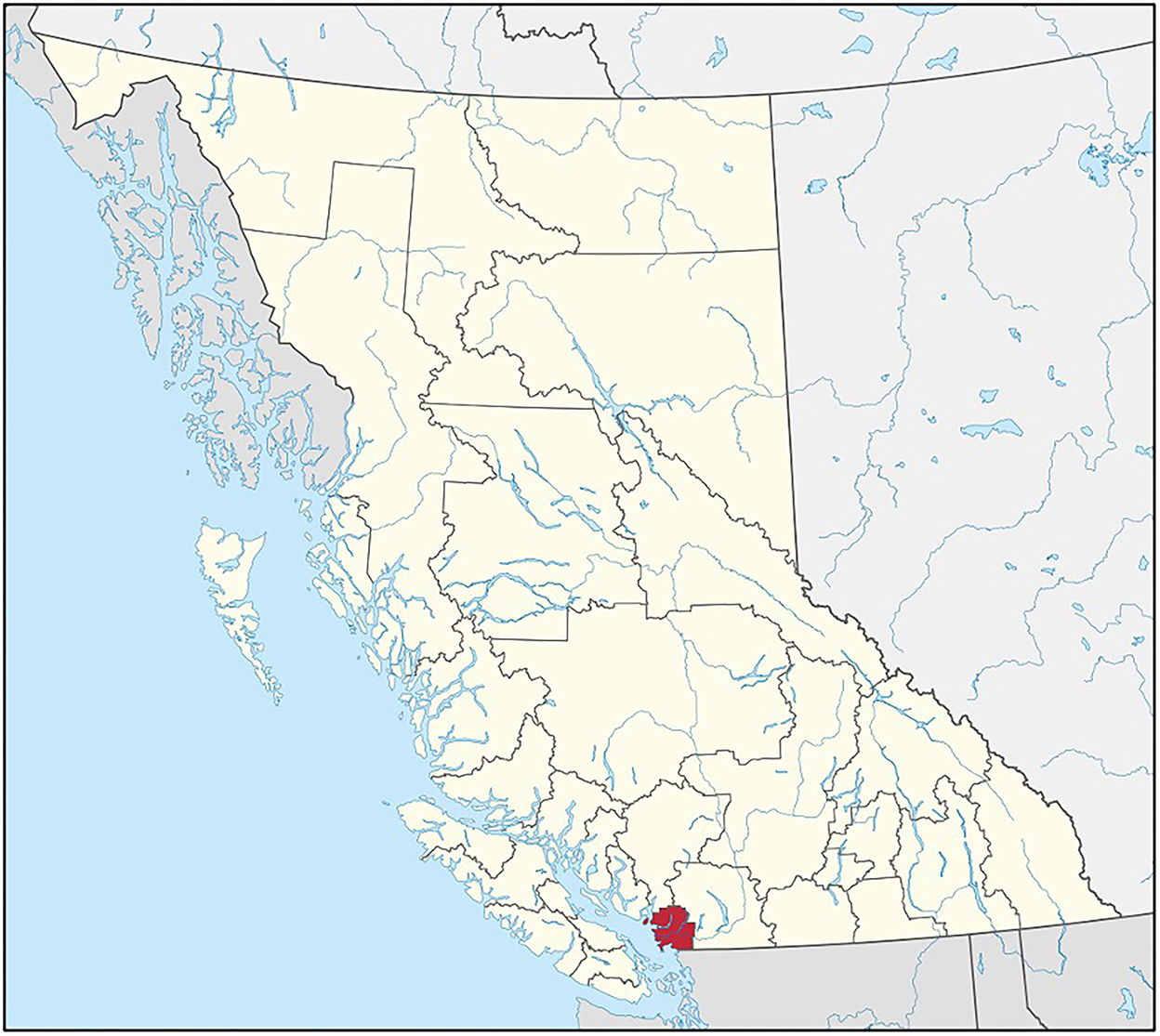
Figure 1. Map of regional districts across British Columbia (BC), Canada with Metro Vancouver regional district highlighted (Awmcphee, 2019).
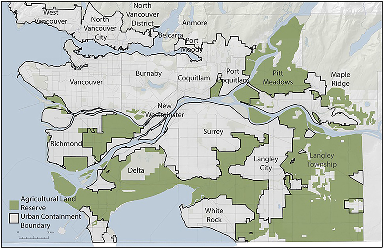
Figure 2. Metro Vancouver region, Canada with Agricultural Land Reserve areas shaded (Metro Vancouver Regional District, n.d.).
2. Agricultural governance and municipal planning
2.1. Agricultural landscapes and complexity
As a complex meta-system comprising multiple sub-systems, agriculture is an expression of many human-environment interactions in dynamic processes shaped by uncertainty, errors, learning, and adaptation (Folke, 2006). For example, multiple socioecological processes arising from other systems (e.g., ecological, socioeconomic, and governing) influence agriculture, such as water availability and quality, pollination, soil and nutrient retention and losses, pest and disease outbreaks, labor availability, market development, and land use legislation (Smith et al., 2012).
The agricultural system includes interconnected ecological and socioeconomic systems. In the ecological system, diversity includes the composition and abundance of biological diversity (crop, wildlife, and pests), and habitat and ecosystem health. Complexity refers to interactions between species, habitats and ecosystems, and human influences (both agrarian and landscape alteration). Dynamics in ecological systems arises from temporal changes (short- and long-term, seasonal) resulting from both internal factors (invasive species, pesticide resistance) and external factors (climate change, wildfires, and flooding). The scale dimension covers the geographical characteristics of the ecosystem (size, boundaries) and its relative uniqueness from other ecosystems (Chuenpagdee and Jentoft, 2009).
In the socioeconomic system of agriculture, diversity includes agricultural and non-agricultural stakeholders and their respective demographics, ideologies (norms, values, and attitudes), relative status and power relations, and land access and ownership models. Governability can be impacted (positively or negatively) based on differential influence over the functioning of the social system. Interactions between stakeholders dictates complexity depending on the degree of interdependency, collaboration, and conflict. Dynamics in socioeconomic systems are functions of change in stakeholder composition, interactions, and the relationships among them. Scale in socioeconomic systems includes the size, range, and mobility of different actors, and groupings of actors. This includes the size and scale of economic operations and livelihoods, and their embeddedness in broader socioeconomic systems (Chuenpagdee and Jentoft, 2009).
2.2. Agricultural governance
Governing agriculture faces both the challenge of complexity and the inclusion of “new” problems, such as climate change, global trade, and food insecurity. The nation-state is no longer the sole governing agent for agriculture (Skogstad, 2008), rather, a governance shift has occurred with broader involvement from private-sector and civil society actors giving shape to policies and legislation (Jessop, 2002; Minnery, 2007). Thus, Canadian agricultural governance, as with other nation-states, is now characterized by broader stakeholder involvement of private sector (e.g., multi-national agri-chemical manufacturers, private consultants, financial institutions) and public sector (e.g., farmers' unions, farmland trusts, sustainable agriculture organizations, and agroecology movements) in governance networks for goal setting, agricultural decision-making, and delivery of services (Haughton et al., 2009; Schmitt and Van Well, 2016). The federal and provincial governments maintain involvement, offering programs to farmers, such as crop and income insurance, environmental farm planning, and agri-business planning. However, local levels of government are experiencing an increasing trend toward shifting and shared responsibilities for agricultural support (e.g., market development, research and innovation) and regulation (e.g., farmland protection, environmental pollution). Additionally, dissolution of government services (e.g., agricultural extension, research) has resulted in private consultants, contractors, and industry associations filling this gap (Markey et al., 2008).
2.3. Challenges in assessing governance of agricultural systems
This shift in governance requires governors, and their agents, to engage with the complexity of interrelationships, interdependencies, and interactions at multiple scales. Scale, as a concept, can be used to demonstrate the way that multiple systems can interact at different conceptual boundaries. For example, farms across an agricultural landscape all have different sub-systems operating simultaneously, such as water, soil, and ecosystem processes and their interactions. These interactions then influence and operate at larger scales as they move beyond farm property boundaries to influence adjacent agricultural landscapes. A challenge is that any planning intervention can influence multiple linkages, altering how the system functions.
Local agricultural governance is influenced by governance processes occurring at the regional, sub-national, national, and global levels. Agricultural planning must consider how nested spatial boundaries and patterns of land use affects various interactions, and processes flowing dynamically across scales (Meyer et al., 2008; Savary et al., 2012). The degree to which these scales interact and are mutually supportive is a key governability issue (Chuenpagdee and Jentoft, 2009). Temporal scales are also relevant to agricultural planning efforts. Farming landscapes arise from historical land use practices developed under strongly coupled, context dependent, socioecological systems (Fischer et al., 2012). For municipalities intervening in agricultural sectors, interpretation of farming issues and sectoral goals requires examination of current system dynamics in the context of changes arising over growing seasons, multiple years, decades, or centuries (see for example Dale et al., 2013). Systems are dynamic and do not remain in fixed states. For example, changes in precipitation, pest and disease outbreaks, temperature, and other natural disturbances can alter the material and energetic flows (e.g., application of pesticides, pumping excess water) within a system.
Governance modes are also diverse, and can present as hierarchical, collaborative, or self-governing, with both formal and informal institutions utilizing a range of policy and legislative instruments (e.g., quotas, taxation, land uses, and permitting) in the agricultural system (Jentoft, 2004). Complexity is present in how institutions interact with external agencies and stakeholders and the degree to which they overlap, differ, conflict, or cooperate. Power relations play a key role in the formation of institutions, the rules and norms (and their enforcement), determining problems and solutions, and determining who participates and who is excluded (Chuenpagdee and Jentoft, 2009). Power is thus a driver of governance system dynamics, resulting in either maintenance of the status quo or initiating change (incremental and radical) (Holt Giménez and Shattuck, 2011).
2.4. Governability as the tool employed to assess municipal governance of agriculture
The concept of governability refers to the degree to which a system can be governed (Kooiman, 2003; Chuenpagdee and Jentoft, 2009). It assumes that there are inherent limits to governing systems (Jentoft, 2007). In agriculture, limited governability relates to the inability of the governing system (e.g., a municipality) to fully control an agricultural system, because system transitions and changes are non-linear and information about the system is incomplete, leading to uncertain, unintended, and unpredictable outcomes (Degnbol and McCay, 2007). Agricultural governance, in a particular regional context, thus requires engagement beyond a singular governing system and depends on responsiveness to multiple interacting systems to address challenges.
With respect to complex systems, Chuenpagdee and Jentoft (2009) provide an assessment framework for examining governability, noting that the measure of how governable a system is determined by “…the particular features of the natural, social systems to be governed, the governing system(s), and the interaction between them” (p. 113). The governability assessment framework (Figure 3) identifies key variables to assess to what extent specific governance efforts achieve proposed outcomes, given the complexity of natural, socioeconomic, and governance systems, and their interactions. The framework can be used to elucidate relative success or failure of specific governance arrangements in relation to specific proposed agricultural outcomes, while also providing insights into what is realistically possible from a specified governing system. Initially, qualitative evaluation of governability is a key step in determining potential for governance (Chuenpagdee and Jentoft, 2009).

Figure 3. Governability model (modified from Chuenpagdee and Jentoft, 2009).
This study describes the specific governance arrangements employed by municipal governing systems to achieve agricultural outcomes and general societal planning priorities. We determine the limitations of municipal governing systems to intervene in agricultural systems and also identify agricultural issues and outcomes that may require alteration of the governing system. Finally, we demonstrate how the municipal governing system, in a particular region, simplifies the agricultural system to make it legible to the governing systems parameters.
3. Planning for agricultural landscapes: The case of Metro Vancouver, BC
3.1. Agriculture in the Metro Vancouver Region
Metro Vancouver comprises 288,268 hectares of land with a population of 2,463,431, situated across 24 local authorities (21 municipalities, one electoral area, one treaty First Nation, and the Metro Vancouver Regional District (MVRD) (BC Ministry of Agriculture, 2014; Statistics Canada, 2016). The total Agricultural Land Reserve (ALR) area in the region is 57,378 hectares, or 1.5% of the province's total farmland. The BC Ministry of Agriculture (2014) MVRD Land Use Inventory indicated that 29,790 hectares (49%) of the regional ALR were actively being used for farming. Of this land base, only 8,174 hectares (13%) are used exclusively for farming, an additional 34,147 hectares (56%) devoted to farming and other uses, and the remaining 23,231 hectares (38%) not used for farming purposes. Examining the range of uses of farmland demonstrates the wide variety of activities that extend beyond strictly agricultural production. This includes residential, transportation, protected environmental features, commercial, utilities, recreation, dumps/deposits, industrial, military, water management, gravel extraction, and First Nations uses (e.g., band administration, ceremonial, harvesting, culturally significant landforms).
The region accounts for a wide variety of agricultural products such as oilseeds and grains; vegetables; fruit and tree nuts; mushroom; livestock (cattle, poultry, turkey, sheep); dairy; eggs; poultry hatcheries; hay; flowers, nursery, and trees; and horses (Statistics Canada, 2021a). In the 2021 Census of Agriculture, the 2,118 farms within Metro Vancouver reported $1.3B in operating revenues, representing 27.4% of the BC share of agricultural operating revenues (Statistics Canada, 2021a,d). Farm revenue distribution varies greatly with over two-thirds making less than $100,000 per year (Figure 4). While most of the farms (1,434) report selling to distributors and large processors (68%), 684 (32%) farms reported selling direct to consumers (Statistics Canada, 2021e). Of these farms, different land tenures operate across the region. Farmland area owned by farms is 62,259 acres (73% of total farm area) and rented/leased land comprised 21,175 acres (25% of total farm area) (Statistics Canada, 2021b).
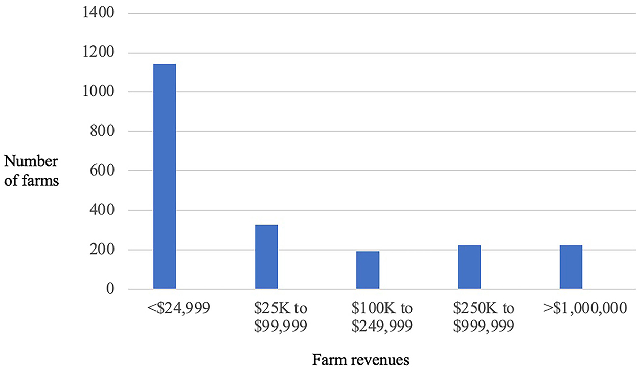
Figure 4. Farm revenue distributions across the Metro Vancouver region, Canada (Statistics Canada, 2021c).
3.2. The municipal land use planning system in Metro Vancouver
Canada is a federal state with national government, provincial/territorial governments, and local authorities. Division of power between federal and provincial governments is constitutionally defined; provinces have full autonomy over land use planning (except for federally controlled lands, e.g., airports, military bases, and allocation of funding through programmes, e.g., infrastructure programmes). Canadian provinces have autonomy to create their own legislative frameworks to structure their planning systems.
Municipal planning legislation was introduced by the BC provincial government with the Town Planning Act, R.S.B.C. (1925) extending the powers of municipalities to prepare and adopt an official community plan (OCP), enact zoning bylaws, and establish a planning commission. In 1957, the Town Planning Act was repealed and replaced with the Municipal Act which provided municipalities authority to enact land use controls, beyond existing powers to regulate buildings (Corke, 1983). These new powers for planning were not compulsory, as land use planning is a voluntary activity. Across the province, municipalities that employed land use controls had the unintended effect of city expansion onto surrounding farmland of adjacent municipalities in the Lower Mainland (Garrish, 2002) (i.e., leapfrog development).
In the post-war period, as the economy grew, zoning bylaws continued to be ignored or circumvented. As Weaver (1979) notes of the nature of planning in Vancouver in the 1950s “businessmen have defined the instruments of land use controls and directed their outcome. Whatever the divergent intellectual and legal traditions in American and Canadian urban planning, the economic imperatives in both countries have presented similar and overruling considerations” (p. 219, cited in Corke, 1983, p. 54). Changes made with the establishment of the Municipal Act in 1957 gave municipalities additional authority (but not compulsory) to establish a zoning board of appeal and to regulate the subdivision of land (Corke, 1983). In 1968, to address fiscal pressures on municipalities arising from new development, the province introduced the development permit as a legal tool which would declare a development area and require obligations from the developer for services (e.g., sidewalks, streetlights, sewage hookups). However, this legislation would be confined to municipalities which had developed an OCP (of which there were very few) and thus the tool was rarely used (Corke, 1983).
From 1957–1977, major issues around the complexity and multiplicity of local government controls over planning, service delivery, and development of land resulted in amendments to the Municipal Act, R.S.B.C. (1979). These changes established a municipal land use control framework featuring the major contemporary planning controls: zoning and subdivision control bylaws, OCPs (voluntary), site-specific and area-specific development permits, and development cost charges and bylaws. In developing OCPs, municipalities must seek comments from the regional district, adjacent municipalities, and provincial and federal levels of government. If a Regional Growth Strategy is in place for the area, the municipal OCP must include regional context statements and align with these policy goals.
3.3. Agricultural planning in BC
Agricultural planning within municipal governments in Southwestern BC includes policies and actions that are either included in an OCP or, in larger communities with extensive farmland, as a separate plan that complements the OCP, as an agricultural plan or strategy (Public Health Services Authority, 2016). Agricultural planning activities typically focus on farming areas, addressing farming supports, challenges and issues, rural character, and role of agriculture in achieving sustainability outcomes through policies, actions, and land use plans (Public Health Services Authority, 2016; Connell, 2020).
Prior to the establishment of the Land Commission Act (now the Agricultural Land Commission Act) in 1973, the principal form of public control over private agricultural land uses across the province was through municipal zoning, and in the Lower Mainland, land use designations in the Official Regional Plan (Smith, 1974). This regional plan would be repealed in the 1980s along with power conferred to regional districts for land use planning (Chadwick, 2002). Thus, agricultural land use planning was subject to the same voluntary controls as other land uses until the creation of the ALR.
Agriculture is identified by Canada's Constitution Act as both a federal and provincial responsibility. The BC Ministry of Agriculture, Food, & Fisheries (BCMAFF) has a role in the delivery of services, programmes, and agricultural policies in support of production, marketing, processing, and sale of agricultural and seafood products. These include programs for business, innovation and market development, crop and farm insurance and income protection, food safety and traceability, environmental sustainability, and farm practices protection, land access and land use planning (Government of BC, n.d.). They have a role in supporting food security, resilient food systems, and economic development in the province.
In 1973, the provincial government created the Agricultural Land Commission Act (ALCA) and the Agricultural Land Reserve (ALR), a provincial land-use zone which would aim to preserve 4.7 million hectares of agricultural lands (Smith, 2012). At the time, estimates of farmland loss were approximately 6,000 hectares annually in the Lower Mainland region (Smith, 1974, 2012). Land use policy issues of additional provincial concern included stabilization of the agricultural land base, increasing concerns with external dependence for food security, recognition that many local authorities were not able to withstand urban development pressures, and a desire to support local authorities' concerns with farmland preservation, global population growth, and food shortages (Smith, 2012). These land use issues set the basis for the top-down establishment of the ALR system from a provincial perspective.
The ALR is based on restrictive land zoning and draws on key elements of the provincial legislative framework including the ALCA (Agricultural Land Commission Act, R.S.B.C., 2002, c. 36), ALR General Regulation (2020) (B.C. Reg. 171/2002), (Agricultural Land Reserve Use Regulation, 2019) (B.C. Reg. 30/2019), (Local Government Act, R.S.B.C., 2015, c. 1), (Land Title Act, R.S.B.C., 1996, Pt. 7, c. 250, s. 86(1)], and (Farm Practices Protection (Right to Farm) Act, R.S.B.C., 1996, c. 131). The Agricultural Land Commission (ALC) is the provincial authority in charge of the ALR. Its mandate is 3 fold:
To preserve farmland, to encourage farming on agricultural land in collaboration with other communities of interest, and to encourage local governments, First Nations, the government and its agents to enable and accommodate farm use of agricultural land uses compatible with agriculture in their plans, bylaws and policies” (Agricultural Land Commission Act, R.S.B.C., 2002, c. 36, Section 6).
Statutory powers of the ALC include approval of applications (e.g., inclusions/exclusions, soil removals/deposits, non-farm uses), and compliance and enforcement via remediation orders and administrative penalties.
Between 1992 to 1994 the LGA was amended to require that municipal and regional governments adopt and amend bylaws to be consistent with the ALCA, regulations and orders of the Commission (Smith, 2012; Connell, 2020). Local government bylaws that are inconsistent are deemed by the provincial government to be not enforceable by local government. A significant local bylaw is the OCP. OCPs are a voluntary form of bylaw that identify a broad range of policies (e.g., land use, economic, housing, transportation, climate change) to guide decision-making, thus managing current and future growth. Local governments are required to forward to the ALC their OCPs prior to adoption for comments (Smith, 2012). However, the BC Ministry of Agriculture, Food and Fisheries (BCMAFF) and ALC do not have authority to approve or require modification of OCPs and zoning bylaws; their comments are restricted to first readings and these provincial entities not required to be involved in subsequent readings or in local decisions (Connell, 2020). The BCMAFF and ALC can provide comments on bylaws that would contravene the provincial legislation, and if necessary, can regulate a municipality. An OCP may contain agricultural policies and may situate these policies across other dimensions of community planning. For example, agricultural policies around farm vehicle road access could be integrated within transportation policies and farmland protection policies situated under urban growth and development policies. Furthermore, agricultural planning identifies policies and actions that are either included in an OCP or, in larger communities with extensive farmland, as a separate plan that complements the OCP, an agricultural plan or strategy (Public Health Services Authority, 2016). Agricultural planning activities typically focus on farming areas, addressing farming supports, challenges and issues, rural character, and role of agriculture in achieving sustainability outcomes through policies, actions, and land use plans (Public Health Services Authority, 2016; Connell, 2020).
Within the ALR, farming uses are exempt from municipal control (e.g., land cultivation, drainage and irrigation infrastructure, application of pesticides and fertilizers) (Agricultural Land Commission Act, R.S.B.C., 2002). Non-farm uses are generally not permitted in the ALR. However, the Regulation acknowledges that there are certain non-farm uses that are necessary for farming operations and divides permitted non-farm uses into two categories: those that can be prohibited by local government and those that cannot. Those that can be prohibited include: certain types of structures (e.g., parking lots, restaurant) and housing (e.g., over two farm residences), non-agricultural home businesses, and soil removal and infill deposits. Examples of activities that cannot be prohibited include: farm structures, parks, temporary gatherings of less than 150 people (such as wedding venue rentals) (Agricultural Land Reserve Use Regulation, 2019). Prior to the 2019 amendments to the ALCA, residential uses would have been included under non-farm uses. Under the recent legislation, farm residences are subject to ALC approval and are limited to two dwellings per parcel which must abide by the terms laid out by the Agricultural Land Commission Act, R.S.B.C. (2002). Local governments have the authority to adopt and enforce more stringent controls over residential uses of farmland (Agricultural Land Commission Act, R.S.B.C., 2002).
Metro Vancouver region is an ideal case to explore governability as it has experienced the highest rates of urbanization across some of the province's most viable agricultural land and is driven by civil society demands for municipal planning interventions in green infrastructure, food security, resilient food systems, farmland protection, and land use change (Metro Vancouver Regional District, 2009, 2011). In the next section, we describe the specific purposes and limitations of municipal governance of agricultural systems in Metro Vancouver, Canada. Specifically, we explore the questions: What are municipal planning systems currently doing to govern complex agricultural systems? What are the limits to municipal governance of agriculture systems?
4. Methods
This study assessed the limits of municipal governments to govern agricultural systems across six municipalities in MVRD, Canada. We employed a qualitative case study methodology (Yin, 2003) to analyze how municipal governments interact with diverse aspects of municipal agricultural contexts, through framings and characterizations of agricultural planning, that constitute a governance system. Data was drawn from interviews with government planning staff and analysis of municipal and provincial policy and legislative documents related to agricultural policy and planning. This research and analysis were guided by two questions: What are municipal planning institutions currently doing to govern complex agricultural systems? What are the limits to municipal governance of agriculture systems?
This study examines all municipalities across MVRD that have published agricultural policy and planning documents: City of Surrey (1999, 2013), City of Pitt Meadows (2000), City of Richmond (2003, 2021), City of Maple Ridge (2009), Corporation of Delta (2011), and Township of Langley (2013). In addition to the stand-alone agricultural policy and planning documents, all six municipalities have adopted an OCP with sections devoted to agriculture, agricultural and/or rural zoning bylaws, and additional bylaws for various agricultural activities. Assessment of the agricultural planning activities and institutions occurred via an examination of municipal agricultural planning documents relevant to the case area including agricultural plans (n = 8), OCPs (n = 6), and provincial legislation (n = 6) (see below for analytical approach). Across municipalities the nomenclature of agricultural plan and agricultural strategy are used interchangeably. These documents exhibited common areas of overlap in scope of work, policy objectives and visions, land use planning elements, zoning and bylaw amendments, economic development initiatives, advocacy, issue identification, and stakeholder representation. In this paper, we use the term plan to refer to both plans and strategies.
In addition to document analysis, we conducted interviews with planning staff and other government officials across multiple levels of government (n = 22). Municipal planning staff for all municipalities with agricultural plans were interviewed (n = 12), as well as one staff person at the Metro Vancouver Regional District (MVRD), eight staff from the BCMAFF (six current employees; two past), and one staff person at the ALC. Interviews were conducted by Zoom or phone over the period of December 2019 to July 2020 lasting from 37 to 159 min.
Data were analyzed through line-by-line coding of interview transcripts, plans and legislation. We employed a deductive approach, creating the initial coding framework from literature on governance (agricultural, fisheries, and municipal) (Higgins and Lawrence, 2005; Skogstad, 2008; Chuenpagdee and Jentoft, 2009), and planning (agricultural, land use, and rural) (Douglas, 2010; Bousbaine et al., 2017). Coding included examination of definitions of agriculture and agricultural planning, agricultural planning activities/practices (design, implementation, evaluation), purposes and outcomes, challenges and barriers, successes and opportunities, planners' roles, and knowledge sources. This allowed for characterization of the municipal planning system for agriculture, the distinct characterization, framing, and understanding of agriculture for each municipality, and assessment of municipal agricultural governance, which in turn, addresses the question: how are municipalities planning for agriculture and what are the limits to governability?
5. Results
Analysis of agricultural plans for the six municipalities shows blended land use planning and economic development approaches to achieve three main goals: (1) conservation of the agricultural land base, (2) economic development, and (3) addressing agricultural conflicts. Planning processes for creation of agricultural plans were initiated by elected officials and subsequently designed and led by consultants. Three different consultants were responsible for the six agricultural plans; Zbeetnoff Agri-Environmental & Quadra Consulting (City of Surrey, 1999; City of Maple Ridge, 2009; Corporation of Delta, 2011). Don Cameron & Associates (Township of Langley, 2013), and Jack Reams (City of Pitt Meadows, 2000; City of Richmond, 2003). Updates to plans in City of Surrey (2013) and City of Richmond (2021) were staff-led. The agricultural plans consisted of similar processes: (i) characterization of the agricultural system, (ii) agricultural stakeholder and public consultation, (iii) an agricultural plan with vision, goals, and objectives and recommended actions. Implementation and evaluation are outlined within the plans, typically with a 20-year horizon. Primary responsibility for implementation across all six municipalities falls on voluntary citizen agricultural advisory committees (AACs) comprised of farmers, non-profit organizations, and provincial staff. Each committee has a designated municipal staff liaison. The municipalities of Richmond and Langley have a full-time planner position responsible for the agricultural portfolio; in the remaining municipalities, planning responsibility is distributed across staff located in multiple departments (e.g., Engineering, Parks and Recreation). Evaluation of agricultural plans occurs on an ad hoc basis depending on direction from mayor and council on specific actions or if a re-design is initiated (Surrey and Richmond).
5.1. Conservation of the agricultural land base
Analysis of the OCPs and agricultural plans for all six municipalities, along with interviews with government, indicates the primary importance of conserving the ALR. Four main rationales for conserving farmland are put forward across the study sites and interviews (i) compliance with the provincial legislation (ALCA), (ii) limiting urban sprawl, (iii) maintaining capacity for future food security, and (iv) ensuring the land base for economic growth. All six municipalities include protection of ALR land as a central policy goal and objective of both agricultural plans and OCPs.
An important purpose for farmland protection is compliance with provincial requirements as municipal planning staff note:
We are trying to at least protect a land base for agriculture, certainly that is through the ALR. That's provincial so I think that is number one…working with the [ALC], the [BCMAFF] because we have to make sure our bylaw and policies line up with theirs. (Participant 9, 2019)
Responsibility for the ALR governance is shared between local government, BCMAFF and the ALC, with varying interpretations of the differing roles and agency in interpretation and implementation of the legislation. The provincial legislation establishes a mandate to ensure that farmland remains in the ALR and that municipal bylaws are aligned with the ALCA. However, while both the ALR and the OCP have legal status, the development, implementation, and evaluation of agricultural plans are voluntary, even as formally adopted by council. Agricultural plans are not required by the LGA nor the ALCA.
Another key purpose linked to regional requirements around growth and development is around urban containment and urban planning. As a provincial government staff notes:
…the land that has the best soil, the best water resources, and the best climate to produce the widest range of crops at the highest productivity; that land should be in agriculture. The human habitation, which is in fact more flexible, should be situated not on that area but somewhere else. (Participant 13, 2019)
Additionally, another provincial staff person speaking to the purpose of agriculture planning states: “…good land use planning in general and we're trying to prevent urban sprawl. We're trying to … force these local governments to do good planning in their urban areas” (Participant 1, 2019). They go on to note key planning failures that impact agricultural lands “…in our urban area we're still doing single family sprawl, we're still allowing big box development, and – oh and by the way, now we're running out of industrial land so we're going to come…begging for land out of the ALR” (Participant 1, 2019).
Some interviewees and plans note the future aspect of farmland protection, that it is about conserving the land base for future food security, acknowledging reliance on distant supply chains. Speaking to this purpose, a municipal planner states: “[Maple Ridge] include[s] that food security lens, as an example of [shorter] food supply chains and how it's kind of important to keep at least some [food] either available locally or be able to ramp up production should the need arise quite quickly” (Participant 3, 2019).
…we need to feed our population this idea for planning for retention of those lands as a reserve is key and so, when we say reserve, it is not land that we farm right now but we need to make sure that that land base is available for whatever farming is available in the future. (Participant 14, 2019)
5.2. Mechanisms to conserve farmland
Under the ALCA, private and public landowners are required to apply to the ALC to include or exclude land in the ALR, subdivide land within the ALR, use land in the ALR for non-farm purposes, and place fill or remove soil. Applications are initially reviewed by local governments and then sent to the ALC for review. The ALC makes the final decision on the application. However, where lands are municipally zoned for agriculture and farm uses, a local government has the power to refuse to forward the application, thus halting the application process. If a municipality wishes to exclude land from the ALR, they also must fill out an exclusion application, provide notice of the application on the farm parcel, provide a public hearing, and notify adjacent local and First Nation governments. Once the public hearing has been held, the municipality must pass a resolution to forward the application along to the ALC. If approved, the ALC holds an exclusion meeting, with representation from local and First Nation government, written submissions, and representation, evidence, opinions from others present. The ALC then provides a decision in writing: refuse, approve (with or without conditions), or approve as an alternate non-farm use (2022).
Agricultural plans aim to achieve the goal of land base conservation by aligning municipal-level bylaws and zoning with upper levels of government and limiting non-farm development on agricultural lands, where non-farm uses do not serve the primary purpose of production. As a result, all agricultural plans analyzed have policies on farmland protection and land use controls for properties in the ALR and along the interface zone between farmland and the rest of the municipality. Agricultural plan policies establish guidance for residences in agricultural and rural zones (e.g., minimum lot size, siting, setbacks, height restrictions, homeplate), permitted land uses, exclusions, and subdivisions, edge planning, and advocacy with different levels of government (e.g., legislative change). Edge planning, managing the interface zone, establishes additional physical separations between the urban and rural through development permit areas which municipalities use to direct and control development (i.e., vegetation, roads, fencing, design standards, and minimum distances).
5.3. Shared jurisdiction for land governance
As provincial government staff describe it, the protection of farmland can be conceived as a three-legged stool. One leg is the ALC, an independent provincial entity charged with the preservation of the ALR. The second leg is the provincial government (BCMAFF) which delivers various programs including support to local government in navigating land uses and questions around farm practices and viability. The third leg belongs to the municipal government with regulatory requirements to maintain the ALR boundary. However, as stated by interviewees and corroborated by OCPs and agricultural plans, the municipal government leg can be “as long or short” as is desired by elected officials. As ALC staff state:
[The local government] role is probably bigger than [the ALC], legislatively, they take a framework that says you should encourage [farming] and…decide if that is meeting the intent of legislation…which they do or don't want, depending on whether they do or don't like the ALR, and the implications it has for growth management and land use planning. So, [the ALCA] is gray in its very design of who has the roles and responsibilities. (Participant 12, 2019)
This power of local government allows for regulatory interpretation which can vary depending on the political will of elected council. For example, restrictions on the size/number of houses on farmland can differ depending on the attitude of elected officials toward farmland protection and development (prior to recent legislative changes). As a municipal employee states:
Council has always been very much about protection of the ALR and very strict about the elasticity of what can and can't happen. A lot of farmers come to us and say, “Well in Surrey they allow us to have two farmhouses and they can all be really huge and why can't we have any size of house we want, we have a big family” and our Council is like, “This is how we protect the land base.” (Participant 8, 2019)
5.4. Economic development
In the previous section, the rationale for the provincial ALR is to protect the capacity for agricultural activities geared toward future food security and urban containment. Municipal agricultural plans advance an additional rationale whereby the protection of farmland for primary production of crops, for sale (direct, local, and international) supports economic development. Agricultural plans for each of the six municipalities each state that economically viable land use is a tool for farmland protection in addition to municipal agricultural zoning and other bylaws, based on a utilitarian logic. This logic states that when agricultural lands that are primarily used for farming purposes, this “soil-bound production” will generate sufficient economic revenue to justify farmland owners keeping farmland within the ALR. This results in a circular, tightly coupled logic that farmland should be regulated to protect the loss of farmland to residential development and other non-farm uses, but also that the primary use of farmland should be farming, as a further protection against prevent farmland losses. For example, the City of Richmond (2021)'s Farming First Strategy includes “Objective 1: Continue to protect the City's agricultural land base in the Agricultural Land Reserve (ALR)” and “Objective 2: Ensure agricultural production remains the primary use of agricultural land.” Policies under the first objective focuses on issues of the urban-rural interface ensuring appropriate buffers, and implementing Development Permit Areas (DPAs), and housing issues limiting the area for and number of residential units. Policies under the second objective address land use issues of non-farm uses (e.g., residential), fragmentation (e.g., linear developments and subdivisions), encouraging soil-based farming, limiting ancillary uses (e.g., retail, storing processing), and soil deposits and removals.
Analysis of documents and interviews with representatives from all six municipalities demonstrated a common view that supporting the business of farming, linked to state-driven economic development activities, will lead to viability of agricultural operations (see below on this tension). For example, Guiding Principle 3 of Richmond's first agricultural plan states: “Agricultural economic growth, innovation, diversification and best practices are the best ways to protect agricultural land in Richmond and to ensure the ongoing viability of agricultural operations” (2003, p.6). Thus, municipal support in economic development achieves both farmland protection and farmer viability. However, supporting economic development for viability of agricultural operations is not the sole objective. Rather, municipalities recognize the potential for downstream economic growth through value-added activities and job creation. For example, one of Maple Ridge's agricultural plan goals states: “Diversified agricultural activity (equestrian, agro-tourism) will protect the land base through active use, create demand for services and workers, and support the infrastructure also required for food production” (2009, p.20).
To achieve these objectives, common recommendations across the six municipalities include (i) public awareness raising of the importance of agriculture as an economic driver, (ii) establishing and supporting direct marketing (e.g., farmers' markets, farmgate sales), (iii) supporting agri-tourism and events, (iv) identifying opportunities for innovation and diversification/value-added, and (v) establishing incentives and linkages with food processing operations (Table 1). Thus, economic development, within the municipal government context, is about mobilizing City resources in creating employment opportunities, supporting local businesses, and inviting new types of businesses. For example, Surrey's Economic Development Strategy identifies economic development as expanding “…society's resources that are used to support the public amenities and services that are fundamental to quality of life, including parks, arts and culture amenities, and health care and education programs” (2008, p.iii). Activities that support economic development in municipal agricultural plans include efforts to address farm viability by creating market opportunities within the geographic polity (e.g., farmers' market, institutional procurement, festivals/tourism events, marketing materials – local food guides) and a recognition of the volatility of commodity crop pricing, the availability and rising cost of inputs, and the increasing cost of land (and leasing land).
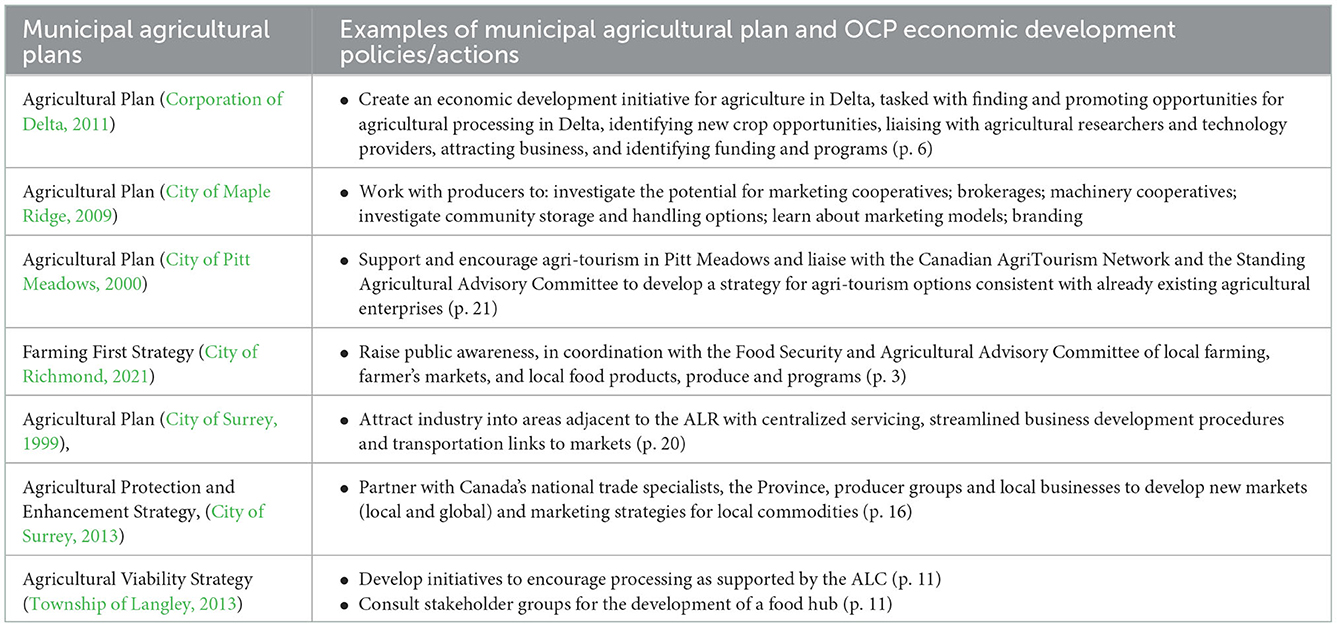
Table 1. Examples of different economic development policies/actions identified across municipal agricultural plans in Metro Vancouver, Canada.
Interviews and six municipalities' planning documents indicate recognition of shared responsibility across different levels of government for economic initiatives but at different levels of involvement. For example, Delta's OCP policy states: “Work with the Ministry of Agriculture, Food and Fisheries, the Provincial Agricultural Land Commission and other farm stakeholders to determine and encourage appropriate economic diversification initiatives” (2010, p.27). Similarly, Richmond's OCP identifies the following policy: “work with partners to expand food production, urban farming and related employment within the ALR (e.g., food processing, storage and shipping, where approved by the ALC)” (2012, Section 6, p. 20).
Differences in degree of municipal intervention is attributed to variation in municipal capacity, political support for agriculture, and the perceived economic contribution of agriculture to the municipality. For example, in Maple Ridge, elected officials' support for economic growth and development is limited. As one staff person relates: “This council is quite challenged with the economic argument of farming, and they don't necessarily see the jobs being supported with the industry and because we have so many small farms it does make it a slightly more challenging economic argument… most of our farmers are not full-time farmers…” (Participant 3, 2020). Additionally, direct municipal actions for economic development are constrained within the planning boundary over which there is government jurisdiction.
5.5. Tensions between farmer livelihoods and land use planning
While there is a strong emphasis on economic dimensions of municipal agricultural support for agriculture, some allowable farm uses that aim to support viability, such as on-site processing or the installation of greenhouse facilities may negatively impact (i) the integrity of the ALR and (ii) the protection of high-quality soils. The emphasis on economic development at local scales can also simplify the complexity of different farm operations and the supports needed. For example, support for particular kinds of different markets can lead to categories of farmers being left out. As a provincial government staff states:
…the message we get from the farmer, the producer that's actually feeding into the bigger food chain, is that they're invisible because they're sandwiched in the middle of lifestyle, homestead farmers and the “super processor,” like where's that medium scale guy who really is actually producing not just processing? (Participant 12, 2019)
All agricultural plans identify two types of farmers: “hobby/census” and “bona fide” farmers to distinguish farmers that are reliant on the productivity of the land and sale of commodities to support themselves and their families. For example, Delta defines “bona fide” farmer as “…a farm operator who uses farmland to produce agricultural products with the expectation of profit” (2011; p.vi). While Maple Ridge identifies the potential environmental contribution of “hobby/census” farms, others maintain that these farms are problematic as they replace economically productive farms: “The OCP identifies the following issues affecting the farm community: Conversion of farmland to hobby-farm use” (Delta, 2011, p. 11). Agricultural plans, however, do not distinguish between different kinds of market-oriented farmers. Rather, there is a widespread acknowledgment that changes to permitted farmland uses, to allow direct-sales and on-site processing, will generally benefit agricultural operations.
Changes in perceptions about the viability of particular economic orientations of agricultural systems were a driver of legislative changes to the ALR that now allow farmland uses that were previously prohibited. Current provincial legislation now permits several non-soil-based agricultural uses and ancillary activities within the ALR. These can include agricultural activities such as greenhouses, cannabis production, broiler barns, mushroom facilities, on-site processing, tasting rooms, fish pens, and vertical agriculture, and non-agricultural uses such as processing facilities, agri-tourism and events, and secondary residential suites. These changes to what constitutes “agriculture” at the provincial level do not necessarily reflect the social imaginary of farming in particular localities, as understood by municipal government staff and decision-makers.
As pressure and availability of land in the urban area disappears there's more and more argument about what seems like very highly commercialized or industrialized activity in the ALR that on the surface is associated with agriculture, but you traditionally wouldn't have found them there” (Participant 12, 2019).
Municipal government, through their development permits and approvals powers, have had to adjust their governance approaches by amending zoning bylaws and development permit approval processes to allow these novel forms of agricultural production.
A major challenge identified by municipal government interviewees is balancing farmer livelihoods with protection of farmland, when livelihood activities, such as short-term rentals, parking lots, and processing facilities can have a deleterious, cumulative impact by paving over high-quality soils thus reducing land available for soil-based farming. A provincial staff member at the ALC also noted concerns about blueberry growers being reliant on a central processor, indicating that many blueberry farmers instead prefer to have their own processing plants on their farmland. This employee goes on to note issues of overbuilding processing capacity:
…one jurisdiction seems reasonable but then you look at what's happening in all of the jurisdictions, there isn't this cumulative impact assessment on the land base and [the ALC] don't issue the building permits and are not there necessarily when someone's saying “I need to build my own processing plant for my blueberries,” and local governments respond: “OK, processing plant for blueberries, approved” (Participant 12, 2019).
This view was a common perspective among interviewees on the development and conversion of farmland. As MVRD staff observe: “[the ALC] accept [non-soil bound production] and then [the farm operation] goes belly up and [the land is] converted and then excluded [from agricultural zoning in the ALR]. That's the problem, it comes in wearing one face and leaves wearing another. Because once you've got the building there, nobody wants to remove the infrastructure” (Participant 15, 2019).
An additional tension arises when looking at agricultural governance from the perspective of soil quality. As an ALC staff puts it, if the model for land use was based on soil capability, then non-soil bound agricultural production [e.g. greenhouses] should be primarily situated in the Kootenay region (a region ~900 km from Metro Vancouver, characterized by hot/dry summers, severe winters, and silt-dominant soils). They go on to state: “Everybody still wants [non-soil bound production] in Richmond where everything's [high quality soils]… but everyone has the equal right to the same opportunities and yet we find them very highly concentrated most of the time near markets” (Participant 12, 2019). For example, Metro Vancouver has seen significant growth in greenhouse production in the region (from 508 farms in 2011 to 611 farms in 2021) (Statistics Canada, 2011, 2021a). Once non-soil-based kinds of agricultural operations are in place, and ancillary structures are developed (e.g., parking lots, concrete foundations), they can heavily influence land prices across the municipality. Speaking to this example, this participant states: “…the price of agricultural land is valued based on the ‘highest and best use' and its ‘highest and best use' isn't primary food production” (Participant 12, 2019). That is, agricultural viability is linked to the value-added activities, not to the primary production of commodities, which in turn can drive farmland prices beyond what farmers can afford.
5.6. Addressing agricultural conflicts
Agricultural plans in the study municipalities explicitly address two kinds of agricultural conflict: urban and environmental. Urban conflicts occur as nuisance complaints, typically by non-agricultural stakeholders (e.g., residents, business owners). This includes several impacts that are the result of normal farm practices, as per the Farm Practices Protection Act, such as dust, noise, odor, and visual aesthetics. In response, all municipalities have designated development permit areas in their OCPs along the interface zone between farmland and the rest of the municipality. These aim to separate urban and agricultural landscapes as a mechanism to mitigate conflict. This represents a key mechanism of municipal planning, on the urban side, to mitigate urban/agricultural conflicts by requiring vegetative buffers, minimum separation distances, trail/road siting, and design standards for development. For example, Maple Ridge's Development Permit area guidelines establish a distinct separation between ALR and urban designated areas (City of Maple Ridge, 2009, p. 13). The rationale is stated by provincial government staff: “We cannot protect these operations like a mushroom operation, a greenhouse operation, a poultry operation from noise, dust, odor, light… types of complaints, if they are outside the ALR. And the local government will shut them down” (Participant 13, 2019).
All agricultural plans identify environmental conflicts as areas of planning intervention. Primarily this includes crop predation from wildlife and urban concerns around environmental impacts of agriculture (e.g., water contamination from nutrient runoff and pesticide drift). For example: “Agriculture has been identified as a potential contributor to fish habitat degradation through improper management of manure, nutrients, pesticide and drainage, and reduction of water availability for fish” (City of Surrey, 1999; p. vii). Earlier agricultural plans frame increased environmental regulation and public demands to minimize the impact of agriculture on the environment as negatively impacting farmers. The common response across municipalities is to encourage adoption of Environmental Farm Plans and identifying technologies and practices that can mitigate harm to wildlife, reduce greenhouse gases, and address environmental impacts from farming. For example: “investigate and adopt new technologies to deal with farm wastes, alternative energy sources, and generation of greenhouse gases” (City of Maple Ridge, 2009, p. 22). Similarly, Richmond's latest agricultural plan states: “Encourage sustainable farming practices, in coordination with relevant City departments, the FSAAC, ALC and Ministry of Agriculture, including water and soil conservation, greenhouse gas emissions reductions and soil management” (City of Richmond, 2021, p. 7).
However, across all municipalities, none identify specific farm practices that cause environmental impacts and that should be prioritized for policy implementation. Furthermore, five municipalities' plans (all except Pitt Meadows) conversely point to the environmental benefits of agriculture and a lack of public awareness of these benefits. For example: “Engage with the Delta Farmland and Wildlife Trust (DFWT) to promote initiatives to foster public awareness of how farmland sustains wildlife and habitat and to build support for more equitable sharing of the costs of providing ecological goods and services” (Delta, 2011, p. 13). Furthermore, three of the municipalities extend this counter-framing to include compensation for farmers employing land management practices that carry environmental benefits. As provincial BCMAFF staff note: “What people value in agriculture and what value do they place in it? And they valued local food, green space, and environment. That is what they valued so that is what they'll fight for and so you need to really take that seriously” (Participant 13, 2019).
6. Discussion
The previous sections described how municipal governing systems utilize several mechanisms and framings for farmland protection, agricultural development, and addressing urban and environmental issues. However, limitations of these agricultural governing systems are apparent in relation to the system dimensions of diversity, complexity, scale, and dynamics.
Diversity is a key attribute of agricultural systems. In the study region, over 200 commodities involving soil-based and non-soil-based agriculture are produced across a wide array of biophysical, socioeconomic, and administrative areas. Furthermore, different farm practices, crops, markets, farm sizes, and land tenure operate across the study sites. However, the findings from this study show that while agricultural systems are diverse, they are governed in similar ways. The governing systems employ similar purposes and logics for farmland protection and simplify urban and environmental issues that hide the diversity within agricultural systems.
The municipal governing system for agriculture, as administered via government staff and elected officials across the six study sites, provides the basis for authority in decision-making, resource allocation, and determining which agricultural stakeholders are included in formal representation (for example via citizen advisory committees). Referring to Chuenpagdee and Jentoft (2009) systems dimensions, the diversity of the agricultural sector is poorly represented within the governing system. Land use bylaws and zoning apply a generalist approach to permitted land uses, treating all agricultural activities equally. Additionally, where the desired principal use of farmland is agricultural production (ideally soil-based), the reality is one of multiple uses occurring simultaneous on a farm parcel. It can include non-farm uses such as residences, farm buildings, parking lots, tasting rooms, processing facilities, dog kennels, community gardens, etc. Regulating multiple uses through a land use planning approach necessitates that the governing system simplifies the agricultural system to make it legible for municipal intervention (Scott, 1998).
Despite the complexity of municipal agricultural systems, our findings show that agricultural planning in the study region hierarchically places importance on protecting the agricultural land base over other non-agricultural economic activities. Agricultural plans for all six study municipalities utilized similar mechanisms to regulate agricultural land-use and protect farmland from urban encroachment and other forms of non-agricultural landuse change. Agricultural planning reinforces a logic whereby farm products should be sold, demonstrating an economic rationale for a strong municipal role in supporting the business of farming (e.g., crop diversification, innovation, marketing, public awareness) and highlighting the contribution of agriculture to economic development (e.g., food business and job creation). The emphasis on primary production as the most important use for agricultural land maintains a simplified solution to agricultural viability. Thus, findings show that while common perceptions of the “highest and best use of land” is residential development, in the context of the ALR and the requirement to maintain the agricultural zone, municipalities are diversifying their plans for economic development to incorporate agricultural products and opportunities to achieve their objectives (e.g., job creation, investment, global recognition/status).
Agricultural plans and OCPs frame complex agricultural issues and problems as having specific and targeted solutions (e.g., farmers' markets and agri-tourism as solutions to farmer economic viability are common across all plans studied). Yet, several agricultural issues are “wicked” problems that cannot be resolved through broad policy statements and/or technical solutions that assume linear causality. For example, diversification of crop production, agri-tourism, and the pursuit of processing/value-added are common interventions to issues of economic viability (see Table 1). However, absent across the agricultural plans is the identification of specific and targeted agricultural products, farms, retailers, that would be suitable for financing, pilot projects, or linkages with agricultural researchers. Nor are there details, or evidence provided, of how a proposed action addresses the given issue or other similar cases or examples where the action was implemented with success.
Agricultural systems in the region are dynamic, experiencing changes with respect to agricultural production and farming practices, the range of provincially permitted farm uses, the issues facing farming and broader society, and the different needs for different agricultural operations to achieve financial viability. However, as agricultural plans are long-term policy documents (~20 years), their implementation are at odds with the dynamics of agricultural systems which operate under different temporalities. Furthermore, there is a limited ability of municipalities to respond to agricultural system changes as the approach to evaluation of agricultural plans is ad hoc with long time periods between plan updates (14 years for Surrey, and 18 years for Richmond).
An associated challenge are changes to the ALCA, and other provincial legislation, which require municipalities to align their bylaws accordingly. Changing bylaws requires staff capacity and resources, time to determine municipal powers (i.e., can local government implement and enforce stricter requirements), and, depending on how controversial the changes are, time for public consultation and for decision-makers to deliberate. As well, agricultural landscapes can dramatically change as farm operations diversify to include on-site processing facilities, retail spaces, and event spaces. The governing systems tend to be more reactive to both the legislative changes and to how farmland owners/agricultural operations enact these new permitted uses. Furthermore, an additional temporal issue arises as municipal decision-makers operate on 4-year cycles which are incongruent with both agricultural plans and the temporal dynamics of agricultural systems.
Across the study region, municipalities operate at multiple scales, from highly urbanized, metropolitan spaces to peri-urban and rural spaces. Municipalities across the study region employ planning approaches to create physical boundaries between farming landscapes and the rest of the municipality through edge planning and interface zones. The governing systems in this case study maintain a division between agriculture (production), as a rural land use, and the rest of the municipality. Maintaining this binary division has contributed to an ongoing paradigm of separation and simplification across municipal planning and agricultural governance activities. This division prevents the governing system from seeing other potential benefits beyond economic growth and development and maintains an antagonistic relationship between urban and agricultural spaces. Other scholars point to agricultural land use patterns and interventions operating across nested, rather than separate, spatial boundaries (Meyer et al., 2008; Savary et al., 2012). Thus, patterns of agricultural and urban land uses produce dynamic interactions and processes between governing scales and agricultural scales. Ultimately, the degree to which scales interact is a key aspect of governability (Chuenpagdee and Jentoft, 2009).
Addressing old and new challenges to agriculture is increasingly seen to range across multiple scales of governance, requiring multi-level governance structures (Curry, 2018). Local levels of government in planning for agriculture are also subject to reconfiguring the objects and subjects of governing agriculture. With the inclusion of new sites of governing (e.g., the environment, animal welfare, consumer safety, recreation, food), these are increasingly incorporated into demands for agricultural space and in notions of place. An ongoing characteristic is the insistence that agriculture is a “unique” and distinct sector; the responsibility of provincial authorities, and the complex challenges facing the sector from urban dynamics and governance. Depending on the level of governance and mandated responsibility to intervene, different spatial imaginaries of agriculture may arise which, in the absence of coordination between levels of government may result in direct impacts to agricultural development and the broader food system. Thus, a key challenge is the scalar focus in agricultural planning on the farm parcel, which, in this region, is mostly under private-property ownership by real estate speculators and/or individual farms as private businesses.
7. Conclusion
Municipalities will continue to play a key role in place-based food systems given their regulatory responsibilities of farmland protection. Their additional powers to go beyond land use mechanisms are timely given impending climate change impacts, and the recognition of unequal power relations and social inequalities arising from food systems, but also the potential of agricultural systems to contribute to more resilient and just food systems. Thus, the objects of agricultural planning practice must transition toward comprehensive food systems planning to incorporate multi-level governance, long-term planning, and inclusion of a broader set of food system stakeholders.
Future research may look to tackle additional questions arising from this study. One set of questions may examine which agricultural subjects are privileged by planning processes, how do these subjects shape the boundaries of municipal governance for agriculture, and how might different agricultural subject formations lead to alternative configurations of agricultural governance. Furthermore, issue identification, visions and goals for agricultural futures, and subsequent interventions/solutions are determined by a key set of actors. These planning processes arise in singular, value-neutral, non-political planning documents and policies. This is quite surprising given the diversity of the agricultural landscape, its stakeholders, and the conflict over land uses and the purpose and form of agriculture. In addition, addressing the question of diversity is key to multi-level governance and comprehensive food system planning. We show that there are multiple planning processes that reproduce a homogenous understanding of agriculture. This research alludes to analyses needed in examining how contemporary agricultural planning may reproduce, or address, social, environmental, and economic inequities. Furthermore, these inequities will have implications for land governance and the role of local government facing new and future challenges, such as environmental and sociopolitical hazards, food insecurity, climate refugees, and ongoing urbanization.
7.1. Study limitations
While the findings of this study are not intended to be generalizable, the insights gathered shed light on municipal approaches to agricultural planning. The influence of urbanization and a dense urban population in Metro Vancouver, as one of the most highly populated areas in Canada, drives issues facing agricultural landscapes and opportunities. With respect to sampling strategies, we were able to recruit agricultural planning staff across the six municipalities. However, even in municipalities where there is a designated staff person, municipal staff roles can touch on agriculture. For example, engineering departments respond to drainage and irrigation infrastructure as part of their responsibilities. These additional staff were not interviewed in this study and could offer deeper insight into each local governments' capacity to govern agricultural systems. A second noteworthy limitation arises in comparisons between municipalities with agricultural plans and those without. Exploring municipalities without designated plans, and their efforts around agriculture and farmland, could prove fruitful to explore barriers to planning system reform and the effectiveness of stand-alone plans and planning outcomes.
Data availability statement
The interview data presented in this article are not readily available as they contain information that could compromise the privacy and anonymity of research participants. Document data (legislation, agricultural plans, official community plans) are publicly available information. Requests to access the datasets should be directed to Y2NkcmluZ0BnbWFpbC5jb20=.
Ethics statement
The studies involving human participants were reviewed and approved by University of British Columbia's Behavioral Research Ethics Board Certificate number H19-00240. The participants provided their written informed consent to participate in this study.
Author contributions
CD led the conception and design of the study, developed the analytical framework, collected and analyzed data, and wrote the first draft of the manuscript. HW and LN contributed to conception of the study, and development of the analytical framework. All authors contributed to manuscript revisions and approved the submitted version.
Conflict of interest
The authors declare that the research was conducted in the absence of any commercial or financial relationships that could be construed as a potential conflict of interest.
Publisher's note
All claims expressed in this article are solely those of the authors and do not necessarily represent those of their affiliated organizations, or those of the publisher, the editors and the reviewers. Any product that may be evaluated in this article, or claim that may be made by its manufacturer, is not guaranteed or endorsed by the publisher.
References
Agricultural Land Commission Act, R.S.B.C. (2002). Agricultural Land Commission Act. c. 36. Available online at: https://www.bclaws.gov.bc.ca/civix/document/id/complete/statreg/02036_01 (accessed December 31, 2022).
Agricultural Land Reserve Use Regulation (2019). B.C. Reg.36/2022. Available online at: https://www.bclaws.gov.bc.ca/civix/document/id/complete/statreg/30_2019 (accessed December 31, 2022).
Andrée, P., Clark, J. K., Levkoe, C. Z., and Lowitt, K. (2019). “Introduction – Traversing theory and practice: Social movement engagement in food systems governance for sustainability, justice, and democracy,” in Civil Society and Social Movements in Food System Governance, eds. P. Andrée, J. K. Clark, C. Z. Levkoe, and K. Lowitt (London: Taylor and Francis) 18. doi: 10.4324/9780429503597-1
Awmcphee (2019). File:CAN BC Greater Vancouver Regional District Locator. Available online at: https://commons.wikimedia.org/wiki/File:CAN_BC_Greater_Vancouver_Regional_District_locator.svg (accessed December 31, 2022).
BC Ministry of Agriculture (2014). Land Use Inventory Report—Metro Vancouver Regional Report Summer 2010 and 2011. Available online at: https://www2.gov.bc.ca/gov/content/industry/agriculture-seafood/agricultural-land-and-environment/strengthening-farming/planning-for-agriculture/agricultural-land-use-inventories/south-coast (accessed December 31, 2022).
Blay-Palmer, A., Santini, G., Dubbeling, M., Renting, H., Taguchi, M., and Giordano, T. (2018). Validating the city region food system approach: enacting inclusive, transformational city region food systems. Sustainability. 10, 1680. doi: 10.3390/su10051680
Borras, S. M., Franco, J. C., and Suárez, S. M. (2015). Land and food sovereignty. Third World Quart. 36, 600–617. doi: 10.1080/01436597.2015.1029225
Bousbaine, A. D., Akkari, C., and Bryant, C. R. (2017). Strategic development planning for agricultural development and the integration of other domains important for the territory. Int. J. Avian Wildlife Biol. 2, 38. doi: 10.15406/ijawb.2017.02.00038
Brinkley, C. (2013). Avenues into food planning: a review of scholarly food system research. Int. Plan. Stud. 18, 243–266. doi: 10.1080/13563475.2013.774150
Chadwick, N. A. (2002). Regional planning in British Columbia: 50 years of vision, process and practice [University of British Columbia]. doi: 10.14288/1.0090197
Chuenpagdee, R., and Jentoft, S. (2009). Governability Assessment for Fisheries and Coastal Systems: A Reality Check. Human Ecol. 37, 109–120. doi: 10.1007/s10745-008-9212-3
City of Maple Ridge (2009). Maple Ridge Agricultural Plan. Available online at: https://www.mapleridge.ca/DocumentCenter/View/370 (accessed December 31, 2022).
City of Pitt Meadows (2000). Pitt Meadows Agricultural Plan. Available online at: https://www.kpu.ca/sites/default/files/Pitt%20Meadows_%20agricultural_plan%202000.pdf (accessed December 31, 2022).
City of Richmond (2003). Richmond Agricultural Viability Strategy. Available online at: https://www.richmond.ca/__shared/assets/viability_strategy6314.pdf (accessed December 31, 2022).
City of Richmond (2021). Farming First Strategy. Available online at: https://www.richmond.ca/__shared/assets/farmfirstrat58299.pdf (accessed December 31, 2022).
City of Surrey (1999). Surrey Agricultural Plan. Available online at: https://www.surrey.ca/sites/default/files/media/documents/SurreyAgriculturalPlanOctober1999reducedsize.pdf (accessed December 31, 2022).
City of Surrey. (2013). Surrey Agriculture Enhancement and Protection Strategy. Available online at: https://www.surrey.ca/sites/default/files/media/documents/AgricultureProtectionEnhancementStrategy.pdf (accessed December 31, 2022).
Clapp, J. (2012). Hunger in the Balance: The New Politics of International Food Aid. NY: Cornell University Press. doi: 10.7591/9780801463938
Clapp, J., and Moseley, W. G. (2020). This food crisis is different: COVID-19 and the fragility of the neoliberal food security order. J. Peasant Stud. 47, 1393–1417. doi: 10.1080/03066150.2020.1823838
Connell, D. J. (2020). Evaluating the Strength of Local Legislative Frameworks to Protect Farmland: City of Richmond and Metro Vancouver, British Columbia. J. Plann. Educ. Res. 2020, 0739456X20943930. doi: 10.1177/0739456X20943930
Corke, S. E. (1983). Land Use Controls in British Columbia [Working Paper]. Centre for Urban and Community Studies, University of Toronto. Available online at: https://tspace.library.utoronto.ca/handle/1807/93828 (accessed December 31, 2022).
Corporation of Delta (2011). Delta Agricultural Plan. Available online at: https://letstalk.delta.ca/28381/widgets/115029/documents/75102 (accessed December 31, 2022).
Curry, D. (2018). Multi-Level Governance in British Columbia: Local Perspectives on Shifting Relations and Structures. BC Stud. 198, 103–124. doi: 10.14288/bcs.v0i198.184843
Dale, V. H., Kline, K. L., Kaffka, S. R., and Langeveld, J. W. A. (2013). A landscape perspective on sustainability of agricultural systems. Landsc. Ecol. 28, 1111–1123. doi: 10.1007/s10980-012-9814-4
Degnbol, P., and McCay, B. J. (2007). Unintended and perverse consequences of ignoring linkages in fisheries systems. ICES J. Marine Sci. 64, 793–797. doi: 10.1093/icesjms/fsm040
Farm Practices Protection (Right to Farm) Act, R.S.B.C. (1996). Available online at: https://www.bclaws.gov.bc.ca/civix/document/id/complete/statreg/96131_01 (accessed December 31, 2022).
Fernandes, N. (2020). Economic effects of Coronavirus Outbreak (COVID-19) on the world economy. Available at Social Science Research Network (SSRN). doi: 10.2139/ssrn.3557504
Fischer, J., Hartel, T., and Kuemmerle, T. (2012). Conservation policy in traditional farming landscapes. Conserv. Lett. 5, 167–175. doi: 10.1111/j.1755-263X.2012.002237.x
Folke, C. (2006). Resilience: The emergence of a perspective for social–ecological systems analyses. Global Environ. Change, 16, 253–267. doi: 10.1016/j.gloenvcha.2006.04.002
Garrish, C. (2002). Unscrambling the omelette: Understanding British Columbia's Agricultural Land Reserve. BC Stud. 136, 25–55. doi: 10.14288/bcs.v0i136.1649
Government of BC (n.d.). Agriculture seafood programs. Available online at: https://alpha.gov.bc.ca/gov/content/industry/agriculture-seafood/programs (accessed December 31 2022).
Haughton, G., Allmendinger, P., Counsell, D., and Vigar, G. (2009). The New Spatial Planning: Territorial Management with Soft Spaces and Fuzzy Boundaries. New York: Routledge. doi: 10.4324/9780203864425
Higgins, V., and Lawrence, G. (2005). Agricultural Governance: Globalization and The New Politics of Regulation. New York: Routledge.
Holland, K. L. (2020). Canada's food security during the COVID-19 pandemic (SPP Research paper 13:13). Calgary, AB: University of Calgary, School of Public Policy. doi: 10.11575/sppp.v13i0.70350
Holt Giménez, E., and Shattuck, A. (2011). Food crises, food regimes and food movements: Rumblings of reform or tides of transformation? J. Peasant Stud. 38, 109–144. doi: 10.1080/03066150.2010.538578
Jentoft, S. (2004). Institutions in fisheries: What they are, what they do, and how they change. Marine Policy. 28, 137–149. doi: 10.1016/S0308-597X(03)00085-X
Jentoft, S. (2007). Limits of governability: Institutional implications for fisheries and coastal governance. Marine Policy. 31, 360–370. doi: 10.1016/j.marpol.2006.11.003
Jessop, B. (2002). Liberalism, neoliberalism, and urban governance: A state–theoretical perspective. Antipode 34, 452–472. doi: 10.1111/1467-8330.00250
Karetny, J. A. (2020). Planning Towards Sustainable Food Systems: An Analysis of US Municipal Food System Plans (Master's thesis, Ohio State University). Available online at: http://rave.ohiolink.edu/etdc/view?acc_num=osu1607085379674489 (accessed December 31, 2022).
Kooiman, J. (2003). Governing as Governance. New York: SAGE Publications Ltd. doi: 10.4135/9781446215012
Land Title Act, R.S.B.C. (1996). Available online at: https://www.bclaws.gov.bc.ca/civix/document/id/complete/statreg/96250_02 (accessed December 31, 2022).
Local Government Act, R.S.B.C. (2015). Available online at: https://www.bclaws.gov.bc.ca/civix/document/id/complete/statreg/r15001_01 (accessed December 31, 2022).
Markey, S., Halseth, G., and Manson, D. (2008). Challenging the inevitability of rural decline: Advancing the policy of place in northern British Columbia. J. Rural Stud. 24, 409–421. doi: 10.1016/j.jrurstud.2008.03.012
Mbow, C., Rosenzweig, C., Barioni, L. G., Benton, T. G., Herrero, M., et al. (2019). “Food Security,” in Climate Change and Land: an IPCC special report on climate change, desertification, land degradation, sustainable land management, food security, and greenhouse gas fluxes in terrestrial ecosystems, eds. P.R. Shukla, et al. Available online at: https://www.ipcc.ch/site/assets/uploads/sites/4/2021/02/08_Chapter-5_3.pdf (accessed December 31, 2022).
Metro Vancouver Regional District. (2009). Metro Vancouver 2040: Shaping our Future. Available online at: http://www.metrovancouver.org/services/regional-planning/metro-vancouver-2040/Pages/default.aspx (accessed December 31, 2022).
Metro Vancouver Regional District. (2011). Regional Food System Strategy. Available online at: http://www.metrovancouver.org/services/regional-planning/PlanningPublications/RegionalFoodSystemStrategy.pdf (accessed December 31, 2022).
Metro Vancouver Regional District. (n.d.). Agricultural Land Reserve Urban Containment Boundary. Available online at: http://www.metrovancouver.org/services/regional-planning/PublishingImages/ALR-Map.jpg (accessed December 31 2022)
Meyer, B. C., Phillips, A., and Annett, S. (2008). Optimising rural land health: From landscape policy to community land use decision-making. Landsc. Res. 33, 181–196. doi: 10.1080/01426390701834524
Minnery, J. (2007). Stars and their supporting cast: state, market and community as actors in Urban Governance. Urban Policy Res. 25, 325–345. doi: 10.1080/08111140701540745
Municipal Act, R.S.B.C. (1979). Available online at: https://www.bclaws.gov.bc.ca/civix/document/id/92consol16/92consol16/1977915826 (accessed December 31, 2022).
Pothukuchi, K., and Kaufman, J. L. (1999). Placing the food system on the urban agenda: The role of municipal institutions in food systems planning. Agric Human Values 16, 213–224. doi: 10.1023/A:1007558805953
Public Health Services Authority (2016). Agriculture's Connection to Health: A summary of the evidence relevant to British Columbia. Available online at: http://www.bccdc.ca/pop-public-health/Documents/AgConnectiontoHealth_FullReport_April2016.pdf (accessed December 31, 2022).
Qualman D. National Farmers Union. (2019). Tackling the farm crisis and the climate crisis: A transformative strategy for Canadian farms and food systems (discussion paper). Saskatoon, SK: NFU. Available online at: https://www.nfu.ca/wp-content/uploads/2020/01/Tackling-the-Farm-Crisis-and-the-Climate-Crisis-NFU-2019.pdf (accessed December 31, 2022).
Savary, S., Horgan, F., Willocquet, L., and Heong, K. L. (2012). A review of principles for sustainable pest management in rice. Crop Protect. 32, 54–63. doi: 10.1016/j.cropro.2011.10.012
Schmitt, P., and Van Well, L. (2016). Territorial Governance across Europe: Pathways, Practices and Prospects. NY: Routledge. doi: 10.4324/9781315716220
Scott, J. C. (1998). Seeing Like A State: How Certain Schemes to Improve the Human Condition Have Failed. Yale University Press.
Seto, K. C., and Ramankutty, N. (2016). Hidden linkages between urbanization and food systems. Science. 352, 943–945. doi: 10.1126/science.aaf7439
Skogstad, G. (2008). Canadian agricultural programs and paradigms: the influence of international trade agreements and domestic factors. Canad. J. Agric. Econ. 56, 493–507. doi: 10.1111/j.1744-7976.2008.00143.x
Smith, B. E. (1974). The British Columbia Land Commission Act-1973 [University of British Columbia]. doi: 10.14288/1.0093604
Smith, B. E. (2012). A Work in Progress—The British Columbia Farmland Preservation Program. 28. Available online at: https://www.alc.gov.bc.ca/assets/alc/assets/library/archived-publications/alr-history/a_work_in_progress_-_farmland_preservation_b_smith_2012.pdf (accessed December 31, 2022).
Smith, P., Davies, C. A., Ogle, S., Zanchi, G., Bellarby, J., et al. (2012). Towards an integrated global framework to assess the impacts of land use and management change on soil carbon: Current capability and future vision. Global Change Biol. 18, 2089–2101. doi: 10.1111/j.1365-2486.2012.02689.x
Sonnino, R. (2013). Local foodscapes: Place and power in the agri-food system. Acta Agric Scand. B. Soil Plant Sci. 63, 2–7. doi: 10.1080/09064710.2013.800130
Statistics Canada (2021a). Table 32-10-0231-01 Farms classified by farm type, Census of Agriculture, 2021. doi: 10.25318/3210023101-eng
Statistics Canada (2021b). Table 32-10-0234-01 Land tenure, Census of Agriculture, 2021. doi: 10.25318/3210023401-eng
Statistics Canada (2021c). Table 32-10-0239-01 Farms classified by total operating revenues, Census of Agriculture, 2021. doi: 10.25318/3210023901-eng
Statistics Canada (2021d). Table 32-10-0240-01 Operating revenues, Census of Agriculture, 2021. doi: 10.25318/3210024001-eng
Statistics Canada (2021e). Table 32-10-0242-01 Direct sales of agricultural products to consumers, Census of Agriculture, 2021. doi: 10.25318/3210024201-eng
Statistics Canada. (2011). Agricultural Census. Available online at: https://www150.statcan.gc.ca/n1/daily-quotidien/120510/dq120510a-eng.htm#:~:text=The%202011%20Census%20of%20Agriculture%20counted%20205%2C730%20census%20farms%2C%20a,been%20declining%20steadily%20since%201941 (accessed December 31, 2022).
Statistics Canada. (2016). Census Profile, 2016 Census—Greater Vancouver, Regional district, British Columbia. Available online at: https://www12.statcan.gc.ca/census-recensement/2016/dp-pd/prof/index.cfm?Lang=E (accessed December 31, 2022).
Town Planning Act, R.S.B.C. (1925). Available online at: https://www.bclaws.gov.bc.ca/civix/document/id/hstats/hstats/991740143 (accessed December 31, 2022).
Township of Langley (2013). Agricultural Viability Strategy. Available online at: https://www.tol.ca/en/the-township/resources/plans-reports-strategies/Strategies-Policies/Agricultural-Viability-Strategy-Final-Draft-(Endorsed-by-Council)-Updated-Appendix-2016-data.pdf (accessed December 31, 2022).
Weaver, J. C. (1979). The Property Industry and Land Use Controls: The Vancouver Experience 1910-1945, Plan Canada, 19/3–4.
Keywords: agricultural planning, municipal governance, agricultural governance, urban food systems, agricultural systems, Metro Vancouver, Canada
Citation: Dring CC, Newman L and Wittman H (2023) Assessing governability of agricultural systems: Municipal agricultural planning in Metro Vancouver, Canada. Front. Sustain. Food Syst. 6:855684. doi: 10.3389/fsufs.2022.855684
Received: 15 January 2022; Accepted: 23 December 2022;
Published: 07 February 2023.
Edited by:
Wayne Caldwell, University of Guelph, CanadaReviewed by:
Rachel Surls, University of California Agriculture and Natural Resources, United StatesPaul Kraehling, University of Guelph, Canada
Copyright © 2023 Dring, Newman and Wittman. This is an open-access article distributed under the terms of the Creative Commons Attribution License (CC BY). The use, distribution or reproduction in other forums is permitted, provided the original author(s) and the copyright owner(s) are credited and that the original publication in this journal is cited, in accordance with accepted academic practice. No use, distribution or reproduction is permitted which does not comply with these terms.
*Correspondence: Colin C. Dring,  Y2NkcmluZ0BnbWFpbC5jb20=