 Andrew McQueen1*†
 Burton Suedel1†
 Sara Copp Franz2
 Tina Cardona3Molly McDermott3Sabrina Collins4Victor Magar5Jeffrey Herzog6
- 1Environmental Laboratory, Engineer Research and Development Center (ERDC), Vicksburg, MS, United States
- 2Ramboll Americas Engineering Solutions, Inc., Denver, CO, United States
- 3Ramboll Americas Engineering Solutions, Inc., Seattle, WA, United States
- 4U.S. Army Corps of Engineers, Huntington District, Huntington, WV, United States
- 5Ramboll Americas Engineering Solutions, Inc., Chicago, IL, United States
- 6U.S. Army Corps of Engineers, New England District, Concord, MA, United States
With the simultaneous rise in coastal flooding risks projected by current climate models and the escalating demands placed on urban infrastructure by population expansion, there is an urgent need for resilient solutions to address these challenges. In response, the adoption of nature-based solutions (NbS) and natural and nature-based features (NNBF) has gained traction as promising, cost-efficient approaches to bolster coastal resilience while offering additional economic, social, and environmental benefits as compared with traditional “gray” infrastructure. While progress has been made in developing and documenting NbS and NNBF approaches for flood risk management globally, uncertainties persist regarding their practical application and effectiveness in highly urbanized coastal environments. Therefore, the objective of this study was to examine the current understanding of NNBF for coastal resilience, providing insights into their potential applications and opportunities in urban coastal settings. To meet this objective, an NNBF principled approach was applied using the City of Boston coastal storm risk management study as an illustrative example. The initial phases of the NNBF guidelines framework was an effective means of organizing and communicating information relevant to the identification and down selection of NNBF alternatives for the region. This study provides valuable insights into the challenges and opportunities of incorporating innovative NbS and NNBF approaches for flooding risks in coastal urban regions.
1 Introduction
Highly urbanized coastal regions are facing unique infrastructure challenges from a combination of population growth demands and increasing risks from current projections of sea level change (Nakamura, 2022). Managing the risk of storms is particularly critical for coastal cities because they contain a concentration of people and related built infrastructure and are often located at low elevations, close to the coastline, and within the flood plains of large rivers (Klonsky et al., 2016; McEvoy et al., 2024). To manage these risks, a combination of solutions is being explored along the continuum of conventional gray infrastructure to nature-based solutions (NbS; USACE, 2013; Suedel et al., 2021). According to Mace et al. (2012), NbS are intrinsically sustainable, enhance ecosystem services (e.g., provisioning, regulating, habitat, and cultural services), and provide other environmental, social, and economic advantages (European Commission, 2021). As a type of NbS, natural and nature-based features (NNBF) have gained increasing traction as promising, cost-efficient approaches to bolster coastal resilience while offering additional social, economic, and environmental benefits. NNBF often consist of natural materials such as sediment dredged from navigation channels (e.g., sand), biomass (e.g., terrestrial and aquatic vegetation), and, to a lesser extent, rock (Bridges et al., 2015, 2021a). However, there remain numerous challenges to implement NNBF in practice, especially in highly urbanized regions with competing demands and space limitations. Therefore, there is a growing need for practical insight and solutions using real-world case studies as examples to provide additional data and other information to overcome these challenges.
The City of Boston, Massachusetts, USA is working with the USACE New England District to develop a coastal storm risk management (CSRM) study for five focus areas around Boston: East Boston, Charlestown, Downtown/North End, Dorchester, and South Boston. The study will incorporate long-term planning for climate change mitigation using Climate Ready Boston (City of Boston, 2016) and other recent coastal resiliency studies (City of Boston, 2022) as a springboard. The role NNBF can play includes managing coastal storm hazards by using existing, restored, or enhanced natural infrastructure features such as vegetation, soils, floodplains, and wetlands (Bridges et al., 2022). These natural features are shaped over time through the actions of physical, biological, geologic, and chemical processes operating in nature and can naturally store precipitation and carbon, hold sediment, and reduce coastal flooding (Bridges et al., 2015). A key benefit of many NNBF is their ability to adapt to changing conditions with minimal further human intervention. For example, in coastal systems with adequate sediment and undeveloped land along the coast, oyster reefs and salt marshes can change elevation with rising sea levels (Altieri et al., 2013; Rodriguez et al., 2014; Kottler and Gedan, 2020; Van Coppenolle and Temmerman, 2020). The inherent adaptability and dynamism of NNBF that are shaped by nature can be key to developing a CSRM study design that if implemented provides more resilient and sustainable infrastructure. However, there remains much uncertainty as to the role NNBF can be used in tandem with conventional infrastructure to provide additional benefits.
In the USA, many NNBF for marine coastal risk management involve creating, preserving, and/or restoring coastal marshes and other shoreline vegetation (O’Donnell, 2017; Bridges et al., 2021a). Coastal marshes dampen waves, trap sediments, and reduce storm surges, all of which have the potential to reduce recovery costs following flood events (Rezaie et al., 2020; Al-Attabi et al., 2023). The type of vegetation, density, and the aerial extent of the vegetated area are key predictors of wetland wave attenuation (Irish et al., 2008; Hijuelos et al., 2019). Extensive stands of woody vegetation such as trees and shrubs can provide the greatest reduction in wave heights and runup with up to 20% reduction of over 40 meters under extreme coastal conditions (van Wesenbeeck et al., 2022). Coastal marshes also provide an array of ecosystem services beyond flood risk reduction such as carbon sequestration, improvements in water quality, fisheries support, and recreational opportunities (Bridges et al., 2015; Pettengill et al., 2018).
Traditional approaches to managing coastal storm risks along urbanized coasts consist primarily of hardened structures such as culverts, seawalls, floodwalls, revetments, and concrete-lined channels, among others. However, these hardened solutions are designed to transport water as quickly as possible (Jones and Macdonald, 2007), while the costs associated with maintenance, modifications, and repairs of this traditional infrastructure under future climate change scenarios are expected to increase (Morris et al., 2020). Hybrid solutions, which incorporate a combination of hardened features (e.g., seawall) with natural infrastructure features (e.g., salt marsh), may enhance a coastal area’s ability to adapt to a changing climate (Huynh et al., 2024).
Solutions to managing flood risk that include natural infrastructure features utilize natural processes while delivering ecosystem services (Schoonees et al., 2019). Coastal infrastructure can be envisioned as a spectrum of solutions ranging from hardened to fully natural (Figure 1). With substantial hardened infrastructure already in place in coastal communities worldwide (Sempere-Valverde et al., 2023), most opportunities to incorporate NbS into infrastructure are expected to consist of greening the gray (e.g., see Coombes et al., 2015; Firth et al., 2024) and employing hybrid solutions (e.g., see Andersson et al., 2022). Features and solutions incorporated into hardened infrastructure are considered green if they perform as intended to enhance ecosystem services related to the structure (Sutton-Grier et al., 2015; Pontee et al., 2016).
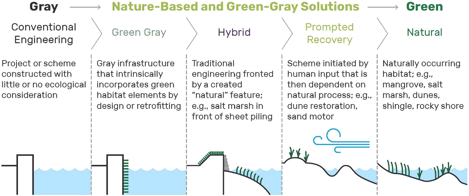
Figure 1. Nature-based solutions can be visualized as a spectrum of techniques ranging from greening gray infrastructure to natural infrastructure (from Suedel et al., 2021).
The objective of this study was to explore the application of NNBF for coastal resiliency in a highly urbanized region through the lens of NNBF initial adaptive management phases (Steps 1-4) as provided in NNBF Guidelines (Bridges et al., 2021a, 2022), using the City of Boston CSRM study as an illustrative example.
2 Approach
2.1 Application of a natural and nature-based features framework
Success in CSRM projects can be fostered by using a framework that integrates NbS into the design of infrastructure planning and engineering design, providing guidance on how NNBF fit into the larger project development process. One such appropriate framework is the International Guidelines on Natural and Nature-Based Features for Flood Risk Management (Bridges et al., 2021a). The Guidelines are based on two complementary frameworks: the USACE NNBF coastal resilience framework (Bridges et al., 2015) and the World Bank (2017) framework, which concentrates on implementing nature-based flood protection measures (see also Sayers et al., 2013). Collectively, these frameworks provide complementary guidance for conducting infrastructure projects that incorporate NNBF and therefore can serve as a road map for incorporating NNBF designs into the City of Boston CSRM study.
The NNBF guidelines framework is composed of five phases: scoping (blue), planning (green), decision-making (yellow), implementation (red), and operations (purple), as represented by the circular arrows in Figure 2. Within those five phases there are 11 steps that when combined are designed to better enable successful NNBF project outcomes. The framework is designed to be iterative, so when new information becomes available during a later project phase, a previously completed phase can be revisited.
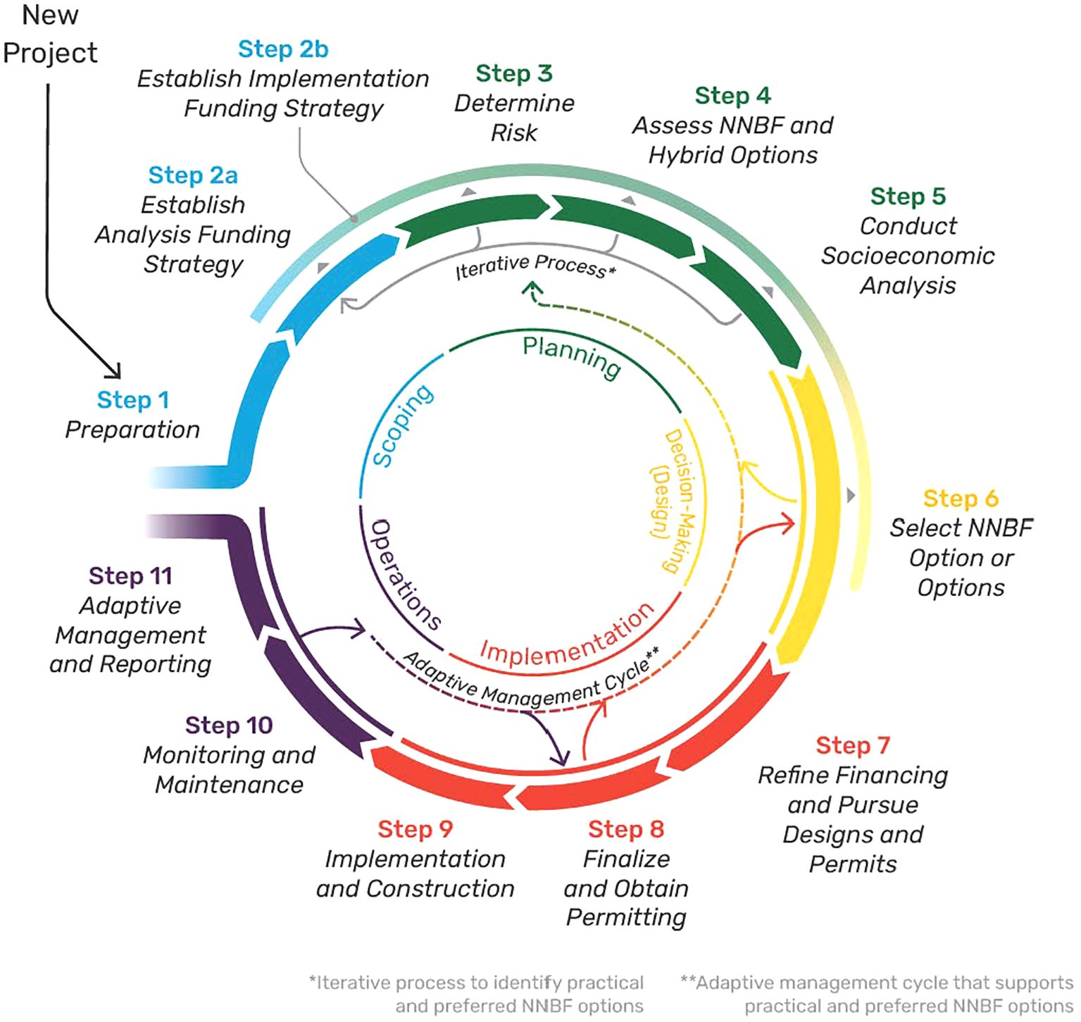
Figure 2. Framework phases and steps for implementing NNBF projects (from Bridges et al., 2021a).
The framework as developed is sufficiently flexible to accommodate USACE studies and projects that manage flood risk. The flood risk management business line of the USACE includes flood risk management in situations where the flooding source is primarily riverine and CSRM where the flooding source is coastal waters (including the Great Lakes). The latter is described in greater detail below as it can be integrated with the NNBF framework. The first two phases (scoping and planning) and their associated steps are presented briefly below as they relate to the status of the City of Boston CSRM study. More details describing the framework can be found in Bridges et al. (2021a, 2022).
2.2 Scoping (steps 1-2)
Scoping involves performing an initial assessment of project needs and objectives, as well as identifying, organizing, and meaningfully engaging stakeholders and partners to integrate their local economic, social, and environmental knowledge into the project design. The problem is also identified and defined during scoping.
In step 1 (preparation), stakeholders and partners are identified, organized, and assembled to define problems and objectives. In steps 2a (establish analysis funding strategy) and 2b (establish implementation funding strategy), funding strategies are established for analysis and implementation. This includes identifying funding mechanisms and cost estimates for planning and engineering activities, design and implementation plans, construction activities, monitoring and maintenance, and adaptive management activities. While an NNBF funding strategy is initiated in scoping, the funding process continues in decision-making and concludes in implementation. The two intended outcomes of the scoping phase are to engage stakeholders and the local community early and often, and to identify the flood-related challenges and encourage stakeholder commitment to actively support the project.
2.3 Planning (steps 3-5)
During the planning process, an improved understanding of the existing system is generated, and NNBF alternatives that meet project goals and objectives within that system are developed. Subsequently, they are advanced from scoping to being investigated, communicated, and rescoped (as needed) to acquire the information and data needed to support decision-making. Planning consists of steps that can achieve greater clarity regarding the selected alternative and what type of NNBFs are most appropriate for the project (i.e., greening the gray, hybrid, prompted recovery, and natural infrastructure; Suedel et al., 2021). As more data become available through activities such as studies, testing, and modeling, the evaluation will transition from more qualitative to more quantitative. Through a systems approach, planning is advanced iteratively so that the most cost-effective and practical NNBF-integrated solution is identified. As related to USACE CSRM studies, in 2023 the USACE released ER 1105-2-103 (USACE, 2023), which included in Chapter 5 policies and guidance specific to CSRM. Under this authority, USACE “may provide federal assistance to manage risk to people, infrastructure and associated resources located along the ocean, estuarine and Great Lake coastlines from erosion, waves and inundation due to coastal storms, along with abnormal coastal and lake flooding when such projects serve the public interest.” (USACE, 2023).
During step 3 (determine risk), the existing system including local and regional conditions is evaluated for hazard vulnerability and flood risk. To do this, coastal and riverine models, such as Advanced Circulation (ADCIRC), Adaptive Hydraulics (AdH), and modeling tools (see examples in Bridges et al., 2018, 2021b) may be needed. The modeling results offer a means of generating data that can support the need for NNBF and highlight the potential environmental, economic, and social benefits of the NNBF alternatives under consideration.
Step 4, Assess NNBF and hybrid options, involves the initial and iterative identification of NNBF options integrated with structural measures that align with project objectives. This step typically engages the multidisciplinary team in data gathering, stakeholder and partner engagement, and workshops. The analysis associated with this step includes determining the extent of NNBF use and evaluating the NNBF or hybrid options. This step of the process may include 1) evaluating the ability of an alternative to reduce natural hazards and vulnerabilities of the systems to flood risk, 2) how NNBF could be integrated as part of multiple lines of defense, 3) how NNBF interact with the geomorphology of the system, and 4) the ability of the system’s physical, biological, and chemical processes to support NNBF in the context of CSRM.
Step 5, socioeconomic analysis, includes an evaluation of the economic, social, and ecological costs and benefits of the NNBF or hybrid options. Consideration of socioeconomic and ecosystem services co-benefits is crucial for informing the selection of options, whether they are structural, nonstructural, NNBF, hybrid, or integrated. For CSRM studies, planning models are utilized to support the appropriate economic and environmental analyses.
The two primary outcomes from planning are identified sources of funding and agreed-upon benefits of implementing NNBF for the system at risk. One outcome product would be an evaluation table that identifies, weighs, and rates categories that can inform numerical rankings for each alternative (see Bridges et al., 2021a for a specific example). When project decision−making requirements are considered, the results of the alternatives analysis allow the high-priority NNBF alternatives to be identified for further deliberation in step 6 (decision-making).
The following case study presents information developed during the planning and scoping phases of the East Boston CSRM study with particular emphasis on considering multiple lines of defense and how they could be integrated and visualized into a cohesive whole for reducing flood risk in the area.
3 Results and discussion
3.1 Case study: city of Boston, USA
Boston is a coastal city with substantial built infrastructure and ecological resources that faces challenges because it is vulnerable to sea level change (Figure 3). These threats could disrupt transportation networks, strain utilities, and compromise the reliability of essential services (City of Boston, 2016). Since 1991, Boston has experienced 21 events that triggered federal or state disaster declarations (City of Boston, 2016). By 2050, Boston is faced with up to 0.45 meters of potential sea level rise and the area at risk of a 1% annual exceedance probability could expand to include over 2,000 buildings, representing $20 billion in real estate value (City of Boston, 2016). Until recently, Boston had primarily used its zoning power to allow new development along an already vulnerable coastline, and the newly developed buildings have become some of the most vulnerable (Fitzgerald and Hobbs, 2022). Consequently, extreme weather events (e.g., nor’easters and hurricanes) have the potential to cause significant damage to Boston’s waterfront areas, infrastructure, and communities. For example, Winter Storm Grayson caused historic flooding throughout the city when it hit on January 4, 2018. Floodwaters reached new highs in Boston Harbor, and future storms could produce similar floods (Nordio and Fagherazzi, 2023).
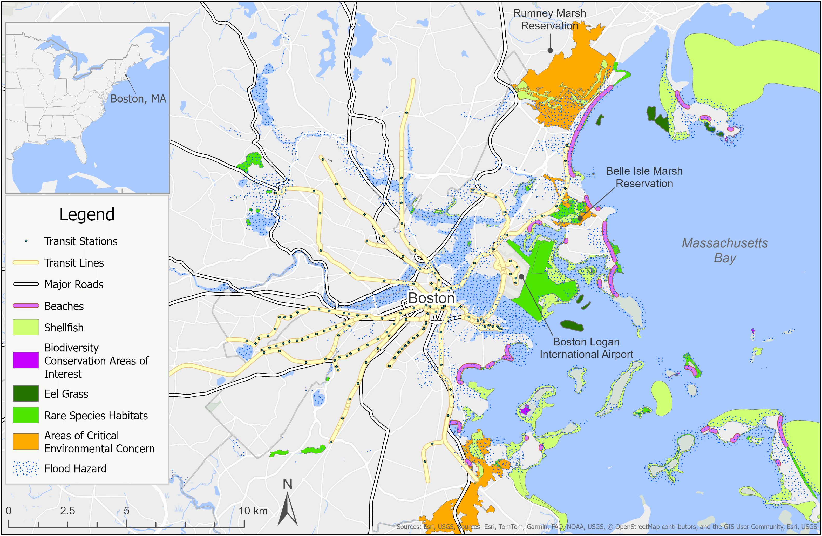
Figure 3. City of Boston, MA USA study area indicating transportation infrastructure, flooding risks, and ecological resources. Note: Data sourced from MassGIS (2025). Sections delineated as areas of critical environmental concern are regions that receive special recognition due to the significance of their natural and cultural resources. The flood hazard layer represents the current effective flood risk data where maps have been modernized by Federal Emergency Management Agency (FEMA) for a 1 percent annual chance flood event.
Boston’s coastal ecosystem includes salt marshes and other wetland and wildlife habitats. Sea level change, increased water temperatures, and ocean acidification have the potential to impact this ecosystem’s biodiversity, fisheries, and recreational resources. Addressing these interwoven challenges has required a comprehensive and multidimensional approach (City of Boston, 2017, 2022; Fitzgerald and Hobbs, 2022). Planning for coastal resilience in Boston began a decade ago with several overlapping planning efforts. In 2014, Boston joined the 100 Resilient Cities program and in 2017 the city released its resilience strategy (Woodruff et al., 2021). Boston also prepared its first comprehensive plan in 50 years, releasing Climate Ready Boston in 2016. This comprehensive plan included a citywide climate change vulnerability assessment, updated climate projections, and an outline of strategies to address extreme heat, stormwater flooding, and coastal flooding from sea-level change and storms (City of Boston, 2016).
USACE CSRM studies are initiated through partnerships between the federal government and non-federal entities to manage storm risks and sustain our nation’s coastlines by predicting impacts from future storm systems, sea level change, and shoreline fluctuations to inform mitigation options. These studies develop and evaluate CSRM alternatives that manage risk and offer coastal resiliency for residents, industries, businesses, and infrastructure. CSRM often includes layered solutions executed by non-federal sponsors, federal agencies, local agencies, and/or non-governmental organizations (NGOs). Collaborators may include the National Planning Center of Expertise for CSRM, local USACE Districts, states, cities, and NGOs. As NNBF are intended to interact with the environment and society in different ways as compared to traditional approaches, values of stakeholders in the design, planning, and implementation phase are important to capture specific regional needs (Yamanaka and Nakagawa, 2022). The purpose of this case study is to provide context and an illustrative real-world example of how NNBF can help inform the existing CSRM scope to inform future design and implementation.
3.1.1 Step 1: preparation
In Boston, the initial scoping phase explored the potential application of NNBF for the city’s coastal storm and flood risk challenges through NbS. The initial step was engagement with a multidisciplinary group of stakeholders and partners to collaboratively define the problems and objectives. Specifically, this step directs practitioners to: 1) identify, organize, and assemble the necessary stakeholders and project partners, 2) define problems, 3) outline the broader system of environmental, urban, and social factors involved, 4) identify opportunities and constraints in the local context, 5) establish goals based on these identified objectives, and 6) develop a vision that incorporates the potential for NNBF to incorporate for flood risk management objectives.
Highly urbanized regions face additional challenges to implementation including social pressure, government policy and regulation, and key stakeholder ‘buy in’ (Sarabi et al., 2019). Therefore, this step in the process is particularly crucial for urban environments that have a large diverse group of stakeholders. In this case study as discussed below, the focus was specifically aimed at identifying examples of NNBF features incorporated into other studies that supported CSRM goals. Therefore, the preparation step will focus on results from stakeholder engagement and opportunities and constraints in the local context.
3.1.1.1 Stakeholder engagement
To explore NNBF opportunities in the study area, engagement included a wide spectrum of stakeholders, ranging from NGOs, Federal, state, and community groups. The NGOs were dedicated to fostering regional collaboration, facilitating community engagement, and driving planning options and communication for the region and its surrounding neighborhoods. Specific goals of this engagement were to explore: 1) opportunities to maintain, restore, or improve shoreline and nearshore aquatic resources in conjunction with CSRM features, 2) opportunities to improve recreational uses through multi-use spaces (e.g., harbor walk, green spaces) in conjunction with CSRM features, and 3) explore gray green (or Nbs) alternatives where space constraints were an impediment to NNBF implementation. A technical team was responsible for collecting and interpreting data, designing studies, and translating and conveying technical information to the broader group. This was achieved through multiple approaches, including in-person stakeholder meetings, attendance of local scientific conferences, podcasts, and gray literature (e.g., Suedel and McQueen, 2022). These stakeholders contributed diverse perspectives to the decision-making process to ensure tailored and desired solutions.
Ecosystem services in the Boston region are supported by a variety of habitat types including salt marshes, freshwater coastal wetlands, beaches, estuarine habitat, oyster beds, eelgrass (Zostera marina) habitats, tidal flats, estuarine habitats, and “core habitats” that sustain species of conservation concern (MassGIS, 2025). Collectively, ecosystem services in the greater Boston area have been valued to range from 30 to 100 billion USD (Jin et al., 2018). Yet, in some cases these ecosystem services are threatened by the projected sea level change (e.g., salt marsh habitats; Alemu et al., 2024). Outcomes from the stakeholder engagements helped identify target ecological goals from NNBF that aligned with the Climate Ready Boston coastal resiliency plans (City of Boston, 2016), which includes enhancing biodiversity and habitat connectivity, balancing urban and natural areas, interconnecting greenways with communities, and expanding and restoring natural systems (e.g., living shorelines, salt marshes, wetlands, urban tree canopies) (Suedel and McQueen, 2022).
3.1.1.2 Problem formulation
To fully understand the associated regional risks, it is essential to consider not just the storm events themselves but also the unique drivers and stressors that amplify their impact in the Boston region. One of the key stressors is the historical modification of Boston Harbor’s coastline, which was extensively filled in during the 19th and 20th centuries to support maritime navigation, trade, and later urban development. This expansion hardened much of the shoreline and occurred without foresight into future sea level changes, making many of these areas particularly vulnerable to flooding and permanent inundation over time. Additionally, Boston Harbor is a federal navigation project with multiple deep-draft channels, such as the Reserve Channel and Mystic River, which are critical to New England’s largest port but also create pathways for storm-driven water intrusion.
Another critical stressor is Boston’s extreme tidal range, which experiences a 10-foot (3 m) tide swing, exposing large portions of the inner harbor bottom at low tide while necessitating an extensive floating waterborne transport infrastructure system. This dynamic tidal fluctuation increases the complexity of flood risk management, particularly under varying sea levels. Importantly, Boston’s flood risk is primarily inundation-driven rather than wave-driven. Unlike many coastal regions where storm waves cause significant erosion and structural damage, Boston faces a growing threat from rising water levels alone. Future projections indicate that what is currently considered a 1% annual exceedance probability flood event in 2025 could become a 10% annual exceedance probability flood event by 2090 (Woods Hole Group, 2023), underscoring the escalating flood risk due to climate change.
These stressors collectively exacerbate the effects of coastal storms, placing critical infrastructure—including roads, public transportation systems, and emergency evacuation routes—at heightened risk. As sea levels rise and inundation events become more frequent, Boston’s resilience strategies must account for these unique challenges, integrating adaptive infrastructure solutions that mitigate long-term vulnerabilities while maintaining the functionality of its vital coastal port and urban landscape.
The surrounding communities are already experiencing an increased threat to mobility and safety during more severe storm events. Additionally, the developed setting creates a tipping point for further flood damage due to the pathways flood waters can take through existing roads, paths, and passages between buildings (flood pathways). Flood hazards to the community include risks to critical infrastructure, evacuation routes, public transportation systems, and electric utilities (Woods Hole Group, 2023). Urban coastal marshes around Boston (e.g., Belle Isle Marsh), face significant challenges due to urban development, artificial fill, stormwater outfalls, and sea level change (Suedel and McQueen, 2022; Woods Hole Group, 2023; Alemu et al., 2024). These human impacts have led to the degradation of the marsh and a decline in its habitat value, and the situation is expected to worsen in the future. Under a 0.3 to 0.9 m of sea level change scenario, the last and largest remaining saltmarsh in Boston (Belle Isle Marsh) would be expected to transform from what is currently high marsh habitat into open water and mud flat habitat (City of Boston, 2016; Massachusetts Office of Coastal Zone Management, 2022; Woods Hole Group, 2023), thus reducing the habitat value and ecosystem services currently provided.
There are numerous challenges to implementing NNBF in urban coastal regions. For example, the lack of space is a key limiting factor in the Boston CSRM study area largely due to existing built infrastructure. In addition, the presence of legacy hardened flood infrastructure such as steel sheet pile bulkheads may limit NbS opportunities; to the extent this existing infrastructure can be enhanced or modified to integrate NNBF, these alternatives should be considered to enhance the value of these otherwise gray structures. Local hydrodynamic conditions such as the presence of deep water, high tides, and a long fetch across Boston Harbor pose challenges to any infrastructure designed to manage flood risk in the study area. The lack of experience designing, funding, and monitoring NNBF may also hinder their application (Kelso et al., 2024). Additionally, there remain many uncertainties related to long-term efficacy for managing flood risks that limit their ability to be upscaled and transferred to different regions (Ruangpan et al., 2020).
3.1.2 Step 2: establish funding strategy
Establishing a funding strategy is critical for planning and implementing urban CSRM. In Step 2, funding streams are explored and identified to find the best series of funding mechanisms that can provide measurable impact to CSRM. In Boston, funding for the CSRM comes from a combination of federal appropriations and contributions from non-federal sponsors. For the Boston CSRM projects, the City of Boston is the non-federal sponsor and will be financially contributing to this effort. Across the United States and within Massachusetts, many programs offer grants to study, plan, and implement coastal resiliency projects. For example, the Coastal Resilience Grant Program managed by the Massachusetts Office of Coastal Zone Management (CZM), and the Municipal Vulnerability Preparedness (MVP) grant program offered by the Massachusetts Executive Office of Energy and Environmental Affairs. Both grants provide support for cities and towns within Massachusetts to begin the process of planning for climate change resiliency and implementing priority projects. Between 2018 and 2025 approximately $72.8 million of funds were distributed and approximately $37 million will be made available in 2025 to fund nature-based inland flooding resiliency projects (Executive Office of Energy and Environmental Affairs, 2024).
The operation and maintenance associated with NNBF is a critical factor to integrate into the long-term planning from the start of the project (Bridges et al., 2021a). Because many aspects of NNBF are dynamic over space and time, monitoring and adaptive management are essential for the success and should be included up front. This approach allows for adjustments over time based on performance data, ensuring that project objectives are being met and long-term strategic goals are achieved. Therefore, planning for performance monitoring is critical to guide these management decisions. The growing global implementation of NNBF solutions is helping to improve understanding, in terms of long-term performance and costs as engineers and scientists continue to share data and lessons learned from these infrastructure projects (Bridges et al., 2021a).
3.1.3 Step 3: determine risk
Managing storm risk is particularly critical for coastal cities because they contain a concentration of people and built infrastructure and are often located at low elevations, close to the coastline, and within the flood plains of large rivers (Klonsky et al., 2016). The primary flood risks in this scenario are from inundation and to a lesser extent wave energy impacts. Two recent examples contributing to such flood risk in the Boston area were winter storms Riley (March 2018) and Grayson (January 2019). Inundation occurs when rising water levels from storm surges, extreme tides, or heavy rainfall flood coastal areas, threatening infrastructure, disrupting utilities, and endangering public safety (e.g. see flood prone regions in Figure 3). The frequency, depth, and duration of inundation can increase with sea level change and the subsequent prolonged flooding can cause economic losses and degrade ecosystems. Wave energy risks stem from powerful storm-driven waves that erode shorelines, damage coastal structures, and disrupt sediment transport. While inundation primarily impacts low-lying areas through flooding, wave energy causes direct physical damage to both built and natural infrastructure.
Urban areas have many impervious surfaces, such as concrete and asphalt, which prevent rainwater from being absorbed into the ground. Instead, water quickly runs off these surfaces and accumulates in low elevation areas. Stormwater runoff can then overwhelm drainage systems, which may be inadequate to compensate. Changes to stream channels resulting from urban development can also limit their capacity to safely discharge floodwaters (Klonsky et al., 2016; Sandink and Binns, 2021). The risk of flooding in each city differs according to climate, soil conditions, regional hydrology, and the use of flood management approaches and technologies (Sandink and Binns, 2021).
A challenge that all cities, but especially coastal cities, face is protecting critical infrastructure. Critical infrastructure includes healthcare facilities, emergency services, transportation routes, government facilities, and water and wastewater facilities (e.g., Figure 3). These community assets are often located in densely populated areas and are expensive to move, even if there is space available to move them. Flooding, including frequent flooding events, can disrupt the services provided daily by critical infrastructure, such as public transportation, emergency response, and water and wastewater treatment. As an example, Boston’s I-90 and Route 1A are transportation routes within areas at risk of flooding during large events (City of Boston, 2016). Yet, both are critical for safe evacuations. Massachusetts Bay Transportation Authority Blue Line stations and a Silver Line station are also projected to be impacted by future flood extents and are relied upon by roughly 14,000 individuals daily. Leaving critical infrastructure vulnerable to flood risks may result in slower emergency response during more severe flooding events.
The risks of flooding for cities include property damage, flood related injuries, and loss of human life. Urban flooding can also lead to sewage backing up, and overflows from combined sewers into surface water bodies, which creates a public health hazard (Sandink and Binns, 2021). Despite the flooding risks, coastal cities continue to experience increases in population size and coastline development (National Research Council, 2014; Klonsky et al., 2016).
There are also substantial competing demands and space limitations in highly urbanized areas, both inland (e.g., commercial and residential development, waterfront access and industrial port development) and in-water (e.g., navigation, offshore energy). This likely remains one of the key risks and barriers to the success of NNBF in Boston. NNBF that could potentially be used to manage flood risk, such as urban marshes, face seaward pressure from sea level change and inland pressure from urban development and population growth (Woods Hole Group, 2016). These twin pressures, combined with the high value of coastal property, create a need to use the most space-efficient measures to reduce flood risks and encourage the concept of bolstering existing marsh habitats (e.g., Belle Isle Marsh) to reverse their declining trajectory (Woods Hole Group, 2022).
Existing urban infrastructure and zoning regulations add a layer of complexity to resilience planning in cities like Boston. Balancing growth of infrastructure in flood-prone areas and/or relocating assets out of flood zones present significant challenges. For example, roadways are large expanses of impervious surface that can increase flood risk but are difficult to relocate or replace because of costs and their criticality as transportation corridors. In other cases, roads can be elevated to create a barrier to coastal flooding or raised on a piled causeway to allow marsh migration and habitat connectivity underneath, hence avoiding road closures during flooding events. Airports may place constraints on applications of NNBF that attract wildlife due to the risk of collision between birds and aircraft and are often protected by traditional flood risk management infrastructure. However, for Boston the Federal Aviation Administration along with the state of Massachusetts has balanced this for >50-years in Belle Isle Marsh. In addition, a matrix of public and private land ownership on coastal property can limit the size and type of NNBF-based CSRM solutions that can be used, making less spatially expansive traditional infrastructure the frequent space-saving alternative of choice, although in our experience space-saving green-gray designs are seldom considered.
3.1.4 Step 4: assess NNBF and hybrid options
NNBF integrated into hybrid or green-gray infrastructure designs can be effective for supporting coastal resilience and promoting risk reduction (Bridges et al., 2015). Assessing the types of NNBF appropriate for a particular application is contingent upon problem formulation and the stressors that drive flood risk. Selection criteria should be both practical and performance based. Key considerations should include the extent to which a proposed solution addresses the target hazard or stated goal, such as wave attenuation, inundation, or habitat enhancement. Feasibility is equally critical to address for determining if the design is constructible within physical, logistical, and legal constraints. Regulatory viability is another factor, especially where habitat conversion poses permitting challenges. Finally, cost comparisons and long-term operation and maintenance requirements must be evaluated to ensure the solution is sustainable beyond initial implementation.
A key benefit of NNBF is the dynamic way that natural elements can respond to changing environmental conditions, such as relative sea level change, without human intervention (Bridges et al., 2021a; Kurth et al., 2024). In addition, NNBF can reduce flood risk while providing environmental, social, and economic benefits to local communities (Davids et al., 2024; Kurth et al., 2024). These strategies can be employed alone or in combination with other structural and non-structural measures; each measure has associated challenges and benefits. One effective way to cumulatively reduce risk is to implement CSRM measures across multiple coastal zones (e.g., nearshore and intertidal) that can provide multiple lines of defense (Figure 4).
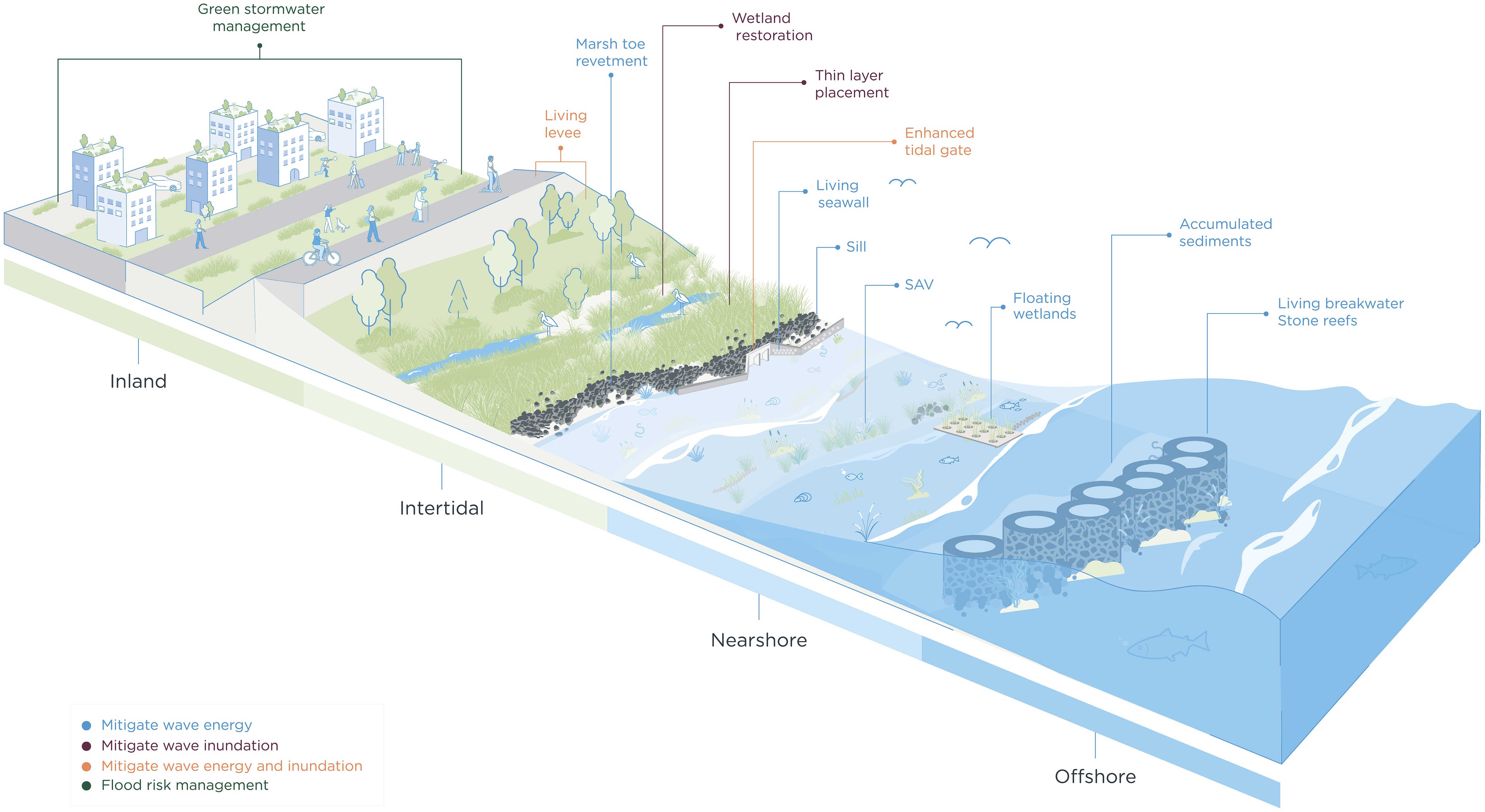
Figure 4. Conceptual diagram of the continuum of NNBF from inland to offshore that can serve as multiple lines of defense for reducing coastal storm risk in urban environments. Note: Feature label format indicates the primary function or mechanism for flood risk reduction.
The following sections provide descriptions and regional context to NNBF in the offshore, nearshore, intertidal, and inland zones and down-select features that provide the best alignment with the CSRM goals.
3.1.4.1 Offshore NNBF and hybrid design
In highly urbanized regions like Boston, features in the offshore area that are not impeded by existing designated uses (e.g., federal navigation channels) may provide unique opportunities because they often do not have the same challenges with competing space demands as inland features. However, the tidal range and nearshore bathymetric profile are key considerations affecting NNBF design and feasibility. Breakwaters are offshore features that occur between open water and the shoreline and are designed to break waves, reduce erosion, and promote sediment accumulation landward of the structure, similar to natural reefs (Chasten et al., 1993). As waves break against the structure, their energy is dissipated, calming the waters on the shoreward side of the breakwater and reducing the direct impacts on the shoreline, thus reducing storm risk (USACE, 1989a; Chasten et al., 1993; Elsheikh et al., 2022).
Scientists and engineers are increasingly incorporating ecological elements (fish spawning substrate, living biota, vegetation, bird habitat, and woody structures) into breakwaters (e.g. living breakwaters) to provide additional benefits (Bassett, 1994; O’Donnell, 2017; Cohen et al., 2021). Simple elements such as spacing of segmented structures, designed elevations, and the incorporation of target habitat can be included in breakwater designs to reduce risk while simultaneously promoting additional ecological benefits (Cohen et al., 2021). Living breakwaters can be engineered within urban areas such as Boston to fit site constraints while providing ample ecological habitat. For example, the Five Sisters segmented breakwater is located 300 meters offshore of Winthrop Beach in Winthrop, Massachusetts, and provides erosion protection and sand deposition along the beach (FitzGerald, 1984; Chasten et al., 1993). This beach, which has increased in size due to the sand deposition enabled by the breakwater, not only protects neighboring communities but also provides recreational opportunities and habitat to threatened and endangered shoreline birds such as least terns (Sternula antillarum), piping plovers (Charadrius melodus), and American oystercatchers (Haematopus palliatus; Winthrop Shores Reservation, 2020). In another example, following Superstorm Sandy, a large living breakwater system was designed in Staten Island, New York to provide erosion protection and ecological enhancement. The system is comprised of nine breakwaters with over 900 linear meters of reef ridges (Tschirky et al., 2018) and contains three types of breakwaters: low breakwaters for shallow water, tighter-spaced breakwaters for critical infrastructure, and large breakwaters in deeper waters to protect against dominant wave direction and allow for sediment transport (Tschirky et al., 2018). The system incorporates various ecological features such as tide pool and ECOncrete® units to create a more diverse aquatic ecosystem (Tschirky et al., 2018).
Like breakwaters, reefs—both natural and artificial—reduce coastal storm risks through wave attenuation and erosion reduction, with the degree of protection depending on their design and position relative to the shoreline. For this discussion, breakwaters are operationally defined as engineered continuous structures built at or above the waterline that are often multi-layered with the primary goal of reducing wave impact and stabilizing shorelines.
In contrast, reefs (engineered or natural) are usually submerged or intertidal and more often are modular or non-contiguous. Reefs can occur across the shoreline continuum including offshore, nearshore, or intertidal areas. In addition to providing shoreline protection, reefs offer habitat and foraging areas for aquatic species (O’Donnell, 2017). Investigators have observed improved water quality and significantly greater abundance, biomass, species richness, and diversity at the oyster reefs when compared to offshore habitats where these features are absent (O’Donnell, 2017; Ayvazian et al., 2020). In New England, natural oyster reefs are largely gone; however, non-profits such as The Nature Conservancy are working to protect and enhance existing reefs by planting oysters in restoration sites in Nasketucket Bay and Buzzard Bay with goals to provide habitat and protect the coast from erosion and storm surge (The Nature Conservancy, 2019; Pereira, 2024). While there is an opportunity to utilize offshore features such as living breakwaters and reefs as lines of defense against wave energy and promote valuable ecosystem services, they do not address the primary risk driver of coastal flooding through inundation for this region. Therefore, offshore measures are not the highest priority in the Boston CSRM study.
3.1.4.2 Nearshore NNBF and hybrid design
Nearshore areas are ideal targets for CSRM in urban regions with competing space demands, as they can utilize aquatic and wetland plant habitats to absorb waves and reduce shoreline erosion. Shallow water provides habitat for a wide range of aquatic organisms including submerged aquatic vegetation (SAV) and oyster reefs (as discussed above). The shallow water within Boston Harbor and Broad Sound contains 11 mapped populations of SAV (eelgrass) and more areas within the harbor are continuing to be restored with eelgrass (Evans et al., 2018; Massachusetts Department of Environmental Protection, 2023). Increasing the total amount of SAV and emergent vegetation across the harbor and shoreline can be used to dissipate wave energy (Irish et al., 2008; Zhang et al., 2020). Irish et al. (2008) found that SAV can reduce wave amplitude by up to 5% per one meter of SAV habitat; likewise, emergent vegetation can reduce wave energy by up to 0.2-28% per one meter of vegetation. Energy from small amplitude waves has been observed to fully dissipate in extensive wetland complexes when waves travel 30 meters through stands of emergent vegetation (Irish et al., 2008). These areas can store excess water during heavy rainfall events, facilitate nutrient cycling, attenuate wave energy, stabilize sediment, and provide a blue (i.e., oceanic or coastal) carbon sink (Schaffer-Smith et al., 2018). This suggests that in areas where offshore wave attenuation is not feasible or permittable, then nearshore emergent wetland habitat and SAV can be established to dampen waves and reduce wave energy impacting hardened coastal infrastructure. Yet, it should be noted that as the presence and density of submergent and emergent aquatic beds (e.g., SAV beds) is dynamic and therefore there is added uncertainty that needs to be addressed in the “multiple lines of defense” design.
Floating wetlands are particularly well-suited for urban and industrial areas with limited space for traditional land-based infrastructure to manage flood risk. Floating wetlands often consist of coconut fiber mats planted with wetland vegetation which can absorb waves, improve water quality, decrease pollutant concentrations, provide aquatic habitat, lower algae biomass, and enhance biodiversity (Bi et al., 2019). Researchers found that the more vegetation on the floating wetland, the greater the wave absorption benefit achieved (Hibbert, 2023). This innovative approach is being tested using laboratory experiments and a prototype in Boston, known as “Emerald Tutu,” as a system of interconnected circular mats of floating wetlands to protect Boston’s urban coast from storms and sea level change (Hibbert, 2023). Current laboratory and modeling results show that the interconnected wetlands should diminish short waves by up to 90% of their original height, with effectiveness decreasing as wavelength increases (Emerald Tutu, 2023). While the study found that effectiveness decreased with increasing wavelength, wave absorption did not drop to zero until the waves reached the combined size of the interconnected wetlands (Emerald Tutu, 2023).
In Provincetown, Massachusetts, USACE is conducting a study that quantifies the reduction of wave energy to local and regional shorelines by deploying vegetated floating canopies. The floating platforms were designed to meet desired wave conditions with the size and shape of the platform determining the amount of wave attenuation (USACE, 2022). Advanced sensors and surveys are being employed to measure wave dissipation and refraction. By integrating these observations into numerical models, the project aims to inform enhanced future deployments of vegetated canopies. The floating vegetation canopy project is anticipated to achieve operational and cost efficiencies, establish new ecological habitats, and contribute to a more climate-resilient shoreline protection solution (USACE, 2022). While these studies are still ongoing, the research indicates that interconnected vegetated floating wetlands could offer improved attenuation of coastal storm wave energies depending on the desired wave conditions and the space available for installing floating wetlands. However, these nearshore NNBF features (SAV restoration, floating wetlands) do not address the primary risk driver of coastal flooding through inundation for this region. Therefore, these nearshore options are secondary when managing flood risk in the Boston CSRM study.
3.1.4.3 Intertidal NNBF and hybrid design
3.1.4.3.1 Wetland restoration
Many NNBF are designed and implemented within the intertidal zone (Bridges et al., 2015). A major focus of CSRM studies that incorporate NNBF is the creation or restoration of wetland habitat such as salt marshes due to their ability to absorb stormwater, dampen waves, trap sediment, and support biodiversity. Studies show that marshes can reduce wave runup by a median of 40 centimeters (cm) and wave height by a median of 35 cm in comparisons to an unvegetated mudflat (Taylor-Burns et al., 2023). It should be noted that wave attenuation is highly site-specific, influenced by various environmental and structural factors. Key variables include wave height relative to water depth, the ratio of wavelength to the width of the NNBF element, and the frictional and blockage effects provided by the feature (e.g., vegetated features) (Li et al., 2023; Ma et al., 2023; Tao et al., 2025). These factors collectively determine the effectiveness of wave energy reduction. Moreover, the required degree of wave attenuation should be tailored to the specific resilience study objectives. Complete elimination of wave energy is often unnecessary; instead, the goal is to reduce wave heights below thresholds that cause erosion or flooding. Establishing clear, site-specific wave attenuation targets is essential for the evaluation, implementation, and effectiveness of NNBF solutions.
In Boston and throughout Massachusetts, there are numerous opportunities to leverage intertidal NNBF for managing coastal storm risk by protecting, enhancing, and expanding existing marsh complexes that protect coastal communities. The Rumney Marsh Reservation and Belle Isle Marsh Reservation, totaling 384 ha of intact marsh around Boston, are critical habitats that offer storm surge energy and flood protection. Other features in this region include shrub-scrub wetlands and cranberry bogs.
Studies are needed to improve understanding how these threatened coastal marshes can adapt to rising sea levels. Not all marsh systems can keep pace with changing sea levels; however, research shows that marshes with high rates of organic production or inorganic sediment delivery can maintain their elevation even with relatively high rates of sea level change (Hein et al., 2024). Marshes can be created on levee slopes or enhanced through methods such as thin-layer placement (TLP) of dredged material. A living levee is a hybrid design that combines a traditional levee core with a wide, vegetated slope that can be designed to support wetland habitats. By using a gradual ecotone slope (e.g., 10:1 to 50:1) planted with native wetland species, it can reduce flood risk while restoring ecosystems and allowing for landward habitat migration if sea levels rise (Bridges et al., 2021a).
Due to the highly altered hydrology of urban marshes, sediment delivery can be hindered and impact the long-term maintenance needs of these features (Woods Hole Group, 2023). These systems rely on natural physical processes—such as tidal exchange, riverine sediment delivery, and organic matter accumulation—to maintain their elevation relative to sea level. Where such processes are diminished or disrupted, NNBF may require ongoing sediment augmentation to maintain elevation and functions. In this case, TLP can be used to ensure the marshes keep pace with sea level change (Piercy et al., 2023; Raposa et al., 2023). For example, Raposa et al. (2023) conducted an comprehensive experiment using TLP to uplift marsh habitat at eight National Estuarine Research Reserves across the United States. The study found that after three years there was minimal adverse impacts to marsh vegetation between 7-cm depth plots and 14-cm depth plots and that following placement, vegetation rapidly established in both high and low marsh environments (Raposa et al., 2023). Overall, while results varied by system, the study found that TLP can serve as an effective climate adaptation strategy in a coastal marsh landscape (Raposa et al., 2023). While there remain uncertainties and constraints related such to TLP applications, guidelines are available to inform implementation that were developed through multi-year collaborations between several agencies (e.g., federal, state) and industry partners to provide practical recommendations supported by case studies and lessons learned (Piercy et al., 2023). These practical guidelines reduce the uncertainty and thus offers an opportunity to evaluate TLP as risk management measure in the Boston CSRM study. Adequate planning, long-term monitoring, operations, and maintenance can be obstacles to successful NNBF implementation due to funding and resource limitations.
3.1.4.3.2 Sills, enhanced tide gates, and living seawalls and levees
Other intertidal NNBF include living seawalls, sills, and enhanced tide gates (Figure 4). In an urban environment with limited space, a traditional floodwall or seawall would occupy minimal space by itself, yet both could be designed, modified, or repaired as hybrid NNBF solutions. Living seawalls are a hybrid solution that can be retrofitted to an existing seawall to create complex surface designs inspired by nature, such as oyster walls. While this concept is relatively new, living seawalls are currently being studied for their effectiveness in Sydney Harbor, Australia, and East Boston, Massachusetts (Bishop et al., 2022; Living Seawalls, 2024). Researchers in Sydney Harbor have found that a variety of living seawall designs can be used to provide different microhabitats while effectively mitigating coastal flood risk (Bishop et al., 2022).
Marsh grasses or SAV planted in front of seawalls can attenuate wave energy, reduce erosion, and provide ecosystem services (Lee and Nepf, 2024). Studies performed in Juniper Cove, Massachusetts, showed that the reduced wave height achieved by marsh vegetation planted in front of a seawall allows for a lower seawall height while maintaining the same level of coastal flood defense (Lee and Nepf, 2024). Rosenberger and Marsooli (2022) also determined that if combined with marsh vegetation, a smaller seawall could be designed while still maintaining the reliability of the structure. Applied in this manner, NbS would provide reduced flood risk (Vuik et al., 2019) and wave loading on the structure (Vuik et al., 2019; Ostrow et al., 2022; Rosenberger and Marsooli, 2022; Marin‐Diaz et al., 2023), while providing environmental and community benefits (Federal Emergency Management Agency, 2022).
Enhanced tide gates and sills can provide multiple engineering and other benefits, including reducing saltwater intrusion, buffering wave energy, and improving coastal resilience. An enhanced tide gate is a modified version of a traditional tide gate designed to improve hydraulic performance, ecological connectivity, and resilience to sea level change and storm events (Suedel et al., 2023). Design considerations for enhanced tide gates include controlled tidal flow, adjustable valves that respond to storm conditions, fish passage support, and improved natural sediment flows into the design basis (see examples in Bridges et al., 2021a). These structures could help regulate water flow, protecting upstream ecosystems from excessive salinity while maintaining tidal exchange. Additionally, they support habitat enhancement by allowing fish passage and promoting the health of aquatic ecosystems (Suedel et al., 2023).
Living levees combine traditional flood protection with ecological restoration, providing structural resilience, environmental, and social benefits. By incorporating native vegetation, living levees enhance carbon sequestration, improve water quality, and promote habitat connectivity. Additionally, they adapt over time, increasing their effectiveness in response to changing environmental conditions. In Eastwick, PA a 1,400 foot long (427 m) living levee was designed to address intertidal and other types of flooding in a low-lying area around Cobbs Creek. The levee, designed as a 15-foot tall (4.6 m) earthen-berm embankment, aims to reduce flood risk to the community from a 1% annual exceedance probability while improving river connectivity, preserving to the extent possible previously restored wetlands, minimizing impacts to existing riparian forest habitat, and minimizing the overall levee footprint while minimizing impacts on community cohesion in this residential neighborhood (King et al., In Press). Given the space restrictions for designing and implementing NNBF in the dense urban environment within the Boston CSRM study area, designs incorporating NNBF should carefully consider these realities. As many of these intertidal features address the primary risk driver of flooding from inundation in a space-constrained and developed coastal environment, these measures will be considered for further evaluation going forward as possible NNBF for managing flood risk.
3.1.4.4 Inland NNBF and hybrid design
Due to intense competing demands on limited space in built coastal environments, there are significant challenges and limitations to implementing inland NNBF. This is primarily due to the relatively small footprint and scale of benefits offered within the space. However, some NNBF have been identified in past projects that may be viable for Boston; such projects are predominately associated with green stormwater management. Regional stakeholders are increasingly interested in green stormwater management. For example, the City of Boston developed the Boston Green Infrastructure Planning and Design Handbook as a guide for implementing green infrastructure techniques to manage stormwater across the city (Boston Water and Sewer Commission, 2022). However, stormwater management is outside the authority of the CSRM study and is a separate piece of the coastal resiliency plan for Boston. Nonetheless, this approach to stormwater management is often a useful strategy that when combined with the other alternatives mentioned above can be used as complementary measures to reduce coastal storm risk. Green stormwater management includes a series of measures such as green parks, rain gardens, bioswales, permeable pavements, rainwater harvesting, downspout disconnection, planter boxes, and green roofs (USACE, 2021). Zimmerman et al. (2016) found these green management measures to be more effective long-term strategies for enabling urban areas to adapt to climate variability and urban development compared to more traditional approaches. As stormwater management is outside the authority of the CSRM study, these should be considered separately as complementary flood risk reduction measures.
3.2 Down selection of alternatives to integrate NNBF into the city of Boston CSRM study
Step 4 offers opportunities to consider ways in which NNBF can be incorporated into the design of the City of Boston CSRM study. Landscape architecture drawings and renderings provide an opportunity to graphically illustrate how NNBF can be integrated into flood risk infrastructure (Holmes et al., 2022; King et al., 2022) (Figures 5, 6). Considering the risk drivers and space restrictions of the region, green-gray and hybrid designs (see Figures 1, 4) offer the best opportunities to include NNBF into flood risk reduction infrastructure measures into the Boston CSRM study. To illustrate this point, a series of renderings were developed to show how the design of traditional infrastructure can be modified to enhance the benefits of the structures (Figures 5, 6) as discussed below.
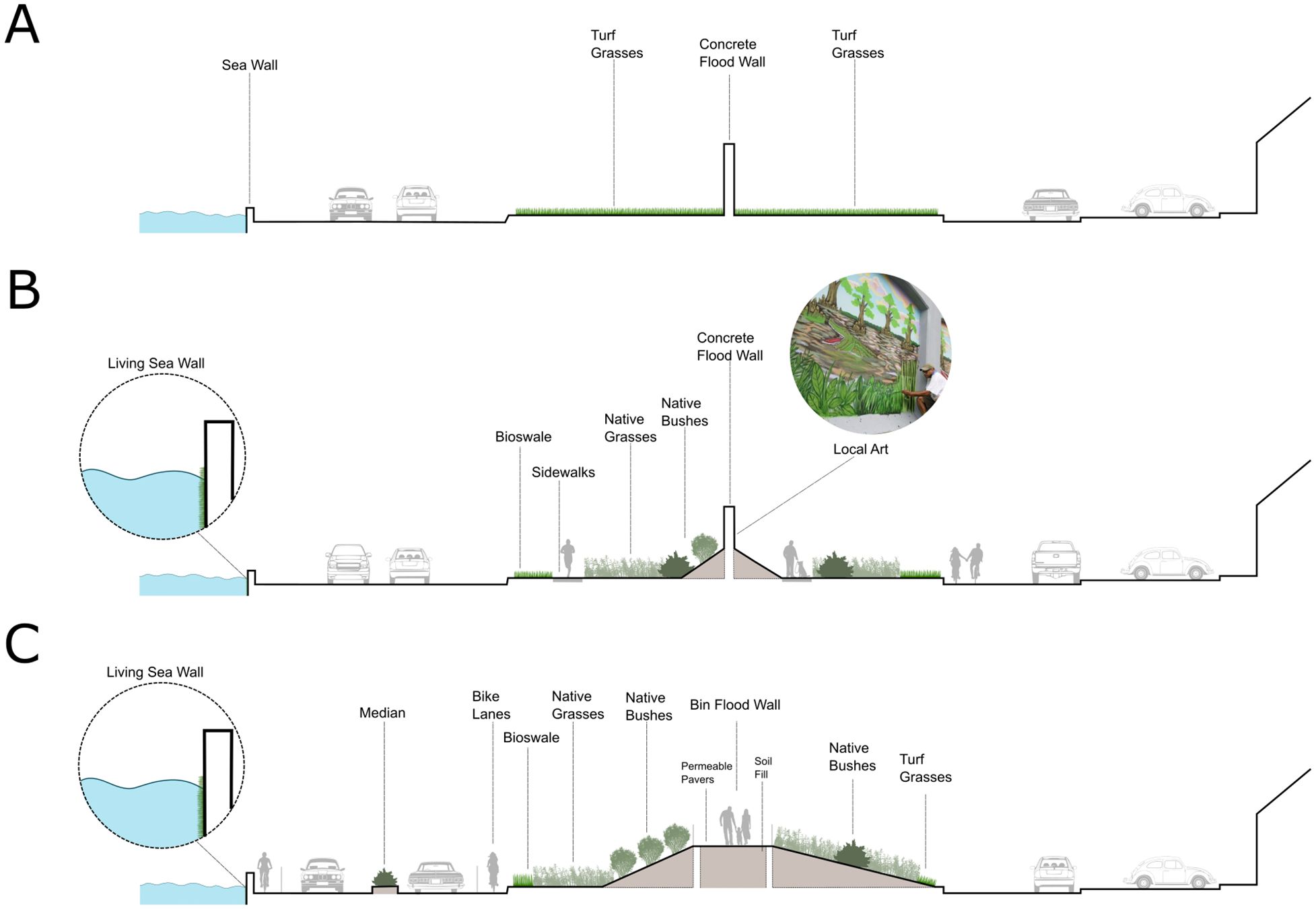
Figure 5. Conceptual renderings of (A) traditional flood wall; (B) a hybrid design consisting of a traditional floodwall combined with natural infrastructure features; and (C) a hybrid design consisting of a bin wall replacement and other natural and nature-based infrastructure features.
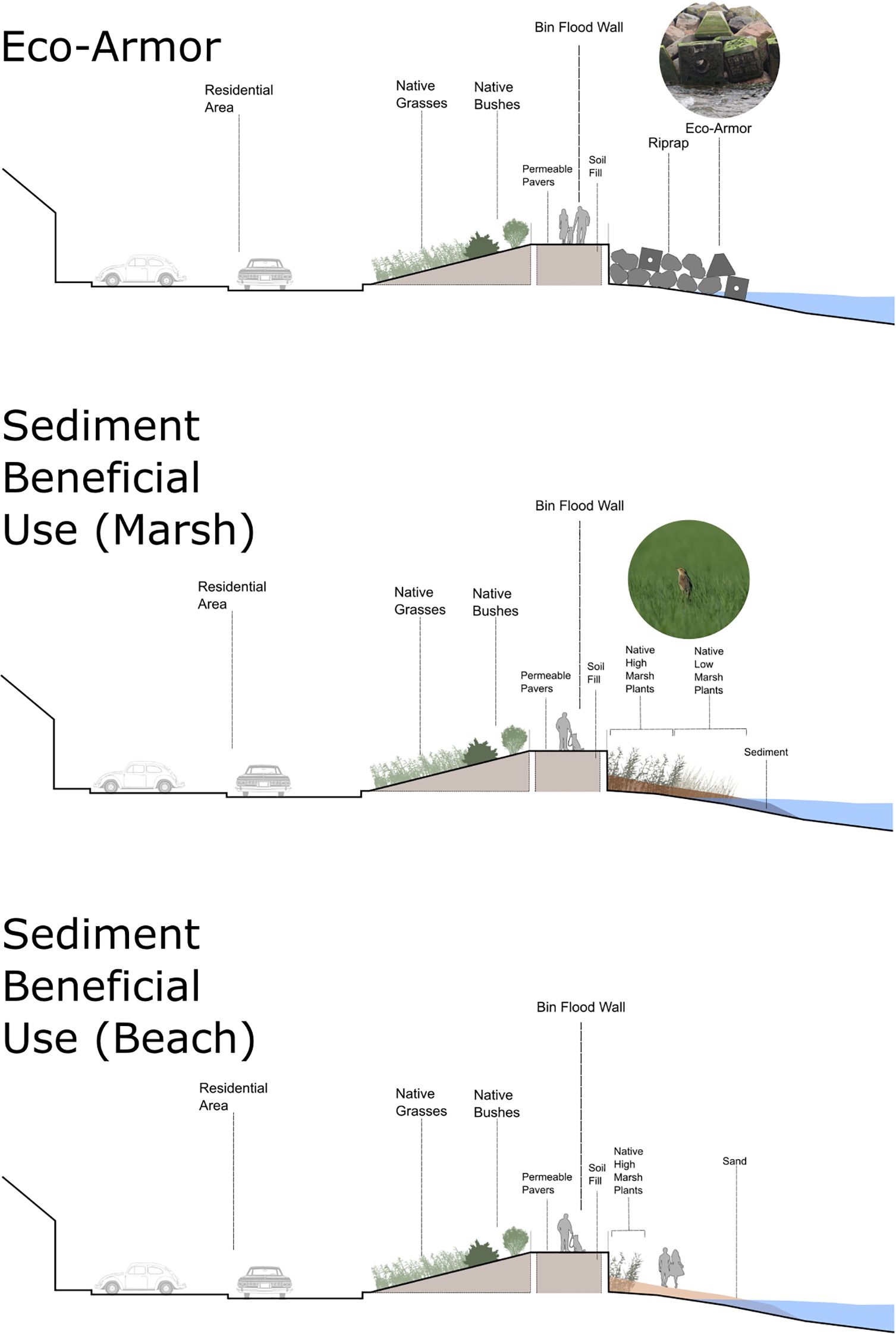
Figure 6. Conceptual renderings of a hybrid design consisting of a bin wall flood protection element combined with natural and nature-based infrastructure features serving as multiple line of defense, including: rip-rap combined with eco-armor units (top); beneficial use of dredged material serving as marsh habitat (middle); and beneficial use of dredged material creating/nourishing a beach (bottom).
For areas where floodwalls are being considered, low-maintenance native vegetation (Gaskin and Thomas, 2025), including woody vegetation such as shrubs with high drag coefficients, can be used in place of turf grass (Figures 5A, B) to soften the view-scape, provide sound-deadening benefits, and attenuate waves (Dalrymple et al., 1984; He et al., 2019);. Considerations for how levee safety buffer zone designs can be modified to enhance the benefits derived from this infrastructure feature is another consideration. Sidewalks made from pervious materials can also be integrated on either side of the flood wall to offer recreational opportunities as well as space for surface water to infiltrate. Project teams can work with local communities for the floodwall to serve as a canvas for locally developed artistic mural designs that reflect the area’s history and community values (Figure 5B). In this manner. meaningful engagement of the local community can enable the integration of an aesthetic component to the floodwall, greatly contributing to the visual appeal of the structure.
A bin wall (e.g., designed as a living levee) or other hybrid designs appropriate for space-limited urban areas could also be designed to manage flood risk (USACE, 1989b). Such a structure could be designed wide enough to serve its intended engineering function while creating an elevated walkway for residents. If an adjacent roadway is present, design elements can be included to reduce the spatial extent of impervious surfaces by replacing these with natural infrastructure materials such as native plantings in a roadway median, further increasing the area for groundwater infiltration, and thereby reducing local flooding (Figure 5C). The concept of a living levee is well known to the Boston area with several proposed designs including a proposed living levee along Bennington Street (Woods Hole Group, 2023); however, there remain challenges including permitting and space constraints. Permitting living levees (and other NNBF) in the Boston area is anticipated to be complex and time consuming, potentially taking years. Key issues include concerns about habitat conversion, especially when levees are proposed behind existing marshes, and the site’s regulatory designations (e.g. Area of Critical Environmental Concern) which may impose additional constraints. Coordination with multiple agencies and compliance with local, state, and federal regulations can lengthen the process. However, well-justified, ecologically beneficial projects can be permitted with diligent planning and early regulatory engagement.
Other opportunities to incorporate NNBF into flood infrastructure are available along the water’s edge. Again, considering space constraints prevailing in the Boston CSRM study area, a traditional floodwall could still be constructed, but designed to incorporate several NNBF to generate benefits beyond the engineered (Figure 6). In areas that border residential neighborhoods, a bin wall could be designed to serve the primary engineering objective but could be bordered street-side by a levee with a lower departure angle serving as a footprint for native vegetive plantings that require minimal maintenance (Figure 6, top panel).
Seaside, riprap armoring could be interspersed with concrete blocks or similar structures whose surfaces and designs have been textured to create habitat niches (Perkol-Finkel and Sella, 2015; Sella et al., 2021; Miller et al., 2022; and projects found in Bridges et al., 2021b; Tritinger et al., 2024). The blocks would offer the desired flood risk reduction benefits while increasing the habitat values associated with that aspect of the structure. The bin wall could be topped with a walkway and guardrails to offer community aspect to the structure and waterfront. In scenarios where roadways or commercial developments border the bin wall, vegetative plantings would serve the added benefits of softening the wall while reducing noise and increasing biodiversity (Figure 6). Here, material dredged from a federal navigation channel could be placed against the bin wall to serve as a foundation for creating marsh habitat while reducing the wave energy impacts on the wall itself.
A similar floodwall walk structure was designed and built in Richmond, Virginia in response to severe flooding that occurred in the 1970’s and 1980’s. The 5 km elevated floodwall system, called the Manchester Floodwall Walk, consists of gravel walking paths on top of the floodwall with safety rails and an overlook, all providing views of the James River, its bank habitats, and the City of Richmond (Manchester Floodwall Walk, 2014). In 2007, Diversity Park was added to the Manchester Floodwall Walk, creating additional recreational opportunities for the local community.
The city of Boston CSRM study offers opportunities to consider how the beneficial use of dredged materials can be used to enhance the value of flood infrastructure measures. Beneficial use opportunities could include contributing to hybrid designs where sediment can be placed in front of hardened infrastructure features such as floodwalls and seawalls to dampen wave energy impacts, reduce flood risk, and to also create marsh habitat features that enhance ecological value associated with the structure (Narayan et al., 2017; Baptist et al., 2019). Serving as a natural resource (Ousley et al., 2024), sediment could be sourced from a local federal navigation channel dredged during routine maintenance. However, implementation of beneficial use is not without its challenges to implement in practice. Barriers to overcome include technical (site access, timing, sediment compatibility), economic (cost of material testing, planning, scoping), and institutional (permitting, Federal standards) issues (Searcy et al., 2021; Ousley et al., 2024). In recent years, much progress has been made to overcome many of these common beneficial use barriers through strategic partnerships, field demonstration of practices, long-term performance data, and quantification of economic, social, and environmental benefits (Searcy Bell et al., 2021; Ousley et al., 2024).
A key opportunity that the CSRM study provides is the potential to leave space for natural infrastructure and associated habitats. Such ecological habitat would not only contribute to managing flood risk but also enhance the economic, social, and environmental benefits associated with the structures (Figures 5 and 6; Bridges et al., 2021a). The presence of Belle Isle Marsh within the study area also presents an opportunity to utilize this natural infrastructure to enhance resilience. The marsh is currently being impacted by sea level change and storms but represents an opportunity to restore this valuable local resource. While the marsh itself may serve a limited capacity as a feature in the Boston CSRM study, sediment TLP is a management action that if implemented can serve to enhance the resilience of the marsh through habitat uplift well into the future.
Space limitations to implementing NbS in coastal marine environments is a challenge that should be overcome. Using a global modeling approach Schuerch et al. (2018) determined that the main driver of global wetland resilience is the availability of space to accommodate sediment accretion and subsequent vertical and lateral growth of wetlands. Yet, built infrastructure in the coastal zone is expected to increase over the remainder of this century, thus serving as a key factor contributing to space limitations. The authors suggested that large-scale loss of coastal wetlands might be avoidable if sufficient space is made available for NbS to be used to manage coastal environments. Therefore, hybrid NbS could be a contributor to limiting and perhaps reversing coastal wetland loss.
3.3 Knowledge gaps and path forward
The performance and intended function of NbS in urban and other developed coastal areas remain key areas of study, particularly in the context of global coastal risks affecting countries in transition. In this study, there are numerous sources of uncertainty that may limit the future implementation NbS in the constraints of highly urban regions, including lack of physical or ecological performance data, lack of economic data, and uncertainties associated with long-term (life cycle) benefits. The uncertainties identified in this study are not unique, but a common barrier to implementation experienced globally. For instance, Paxton et al. (2024) reviewed 252 studies on NbS interventions for coastal protection to better understand what key data gaps need to be prioritized in future efforts. Results from the review indicated that long-term performance of NbS was rarely evaluated, with most studies occurring over short timeframes (less than one to five years). Additionally, most studies reviewed rarely incorporated social or economic metrics (Paxton et al., 2024). Similarly, Ruangpan et al. (2020) analyzed 146 studies on NbS efficacy for flood risk reduction and found that key data gaps included long-term effectiveness, performance when combined with gray infrastructure. Notably, 82% of these studies reviewed in Ruangpan et al. (2020) focused on urban flood risk reduction, indicating the global opportunities and interest in populated urban regions.
A recurring theme in the literature, as noted by Ruangpan et al. (2020), is the need for standardized frameworks to select, evaluate, and design hybrid NbS approaches. Yet, the benefits provided by “prescriptive” standardized approaches need to be balanced with methods that are appropriately flexible and iterative to be applicable to a wide range of practitioners, geographic regions, funding, and project scales. Recent advancements, such as the development of NNBF guidelines (Bridges et al., 2021a, 2022) have made substantial progress in addressing these aspects of an adaptable, transparent, and repeatable framework for NNBF implementation. In addition, this case study highlighted that many Nbs lack the at scale applications and the effectiveness of NNBF for mitigating flood risks from inundation (e.g., flood risks from tidal surge and storm surge; see Table 1). However, there remain many questions of the cumulative benefits that can be achieved by multiple NNBF and NBS at a “system” or regional scale. In a recent example of a large-scale coastal barrier island restoration, Tritinger et al. (2025) demonstrated that through sustainable engineering principles and integration of multiple natural and engineered ecosystem components at a regional scale, enhanced social, economic, and environmental outcomes were achieved. While there remain many uncertainties, information from real-world case studies - like presented here - are essential for demonstrating practical applications and facilitating NNBF implementation in practice.
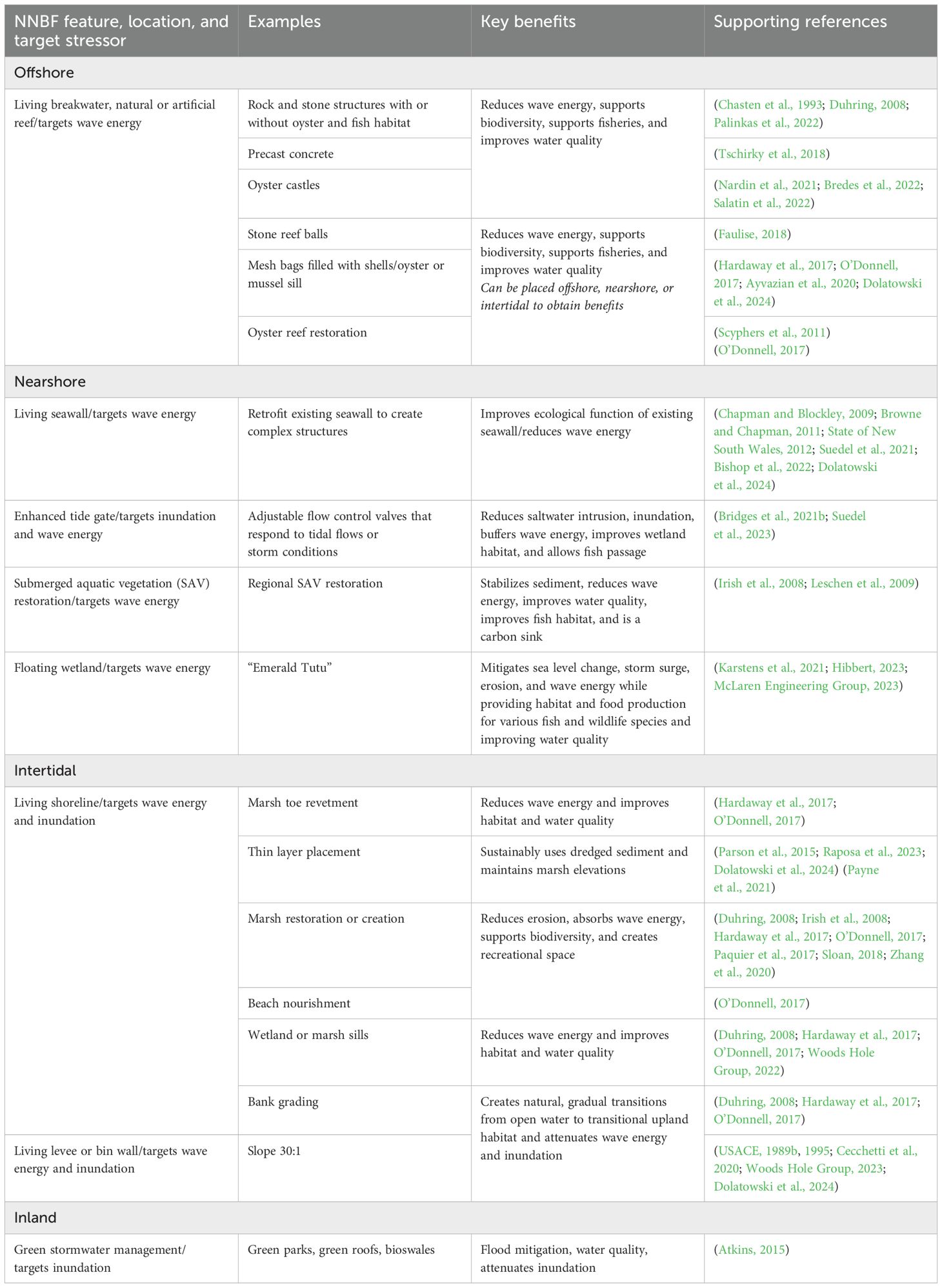
Table 1. Examples of NNBF features and hybrid solutions and their potential benefits for CSRM application.
4 Conclusions
Traditional gray infrastructure remains a critical asset for CSRM to defend against flood related events in many coastal regions. Yet, current climate projections indicate increasing risks due to relative sea level change and the rise in the human population in flood-prone areas. Therefore, there is a growing need to innovate the design and implementation of traditional infrastructure to meaningfully improve coastal resiliency, reduce flood risk, and broaden benefits. This is a common scenario globally as many urban populations are continuously expanding while space to implement NbS along the coastline is shrinking (Nakamura, 2022). While NbS are increasingly recognized as alternatives to mitigate some stressors addressed in CSRM, identifying NNBF that mitigate risks of inundation within the space constraints of a highly urbanized region were limited. Therefore, a key data gap in the current study was the lack of at-scale examples of NNBF with the objective of reducing coastal storm risk associated with inundation. Additionally, in the Boston CSRM study a primary concern expressed during stakeholder engagements was the lack of long-term efficacy data related to NNBF as flood risk reduction measures. For these reasons, NbS alternatives include the design of green-gray and hybrid systems (i.e., hybrid bin flood walls) offer more practical solutions for including NNBF while broadening the benefits associated with flood risk reduction infrastructure in Boston CSRM study area.
Urban coastal environments require planning and design alternatives that can overcome space limitations and dense populations. In this study, the initial phases of the NNBF guidelines framework (steps 1-4) was shown to be an effective means of organizing and communicating information relevant to the application of NNBF alternatives in the Boston CSRM study. As risk managers develop CSRM measures in urban environments, they should consider ways in which innovative NNBF can be incorporated into planning, designing, and implementing efforts to ensure long-term resilience for both the built and nature-based infrastructure and the communities that rely on them. A key enabler to implementing NNBF is that public perception and social acceptance of NbS as alternatives to traditional infrastructure was not a concern expressed by stakeholders in the Boston CSRM study.
Local communities are funding planning efforts to implement NbS for coastal resiliency in their communities. In collaboration with community groups and non-profits, the Town City of Revere, City of Winthrop, and East Boston have funded studies to provide valuable insights into the risks and challenges faced by these communities located within the CSRM study area. Applying the NNBF framework underscores not only the urgent need for action to protect local communities, but also highlights the importance of collaboration between various stakeholders and the potential of NbS in addressing the challenges posed by a changing climate. The application of the first to phases of the NNBF approach as presented herein serves as a crucial step towards a more resilient future for both the people and infrastructure within the City of Boston CRSM study area.
Data availability statement
The original contributions presented in the study are included in the article. Further inquiries can be directed to the corresponding author.
Author contributions
AM: Conceptualization, Formal Analysis, Funding acquisition, Investigation, Methodology, Supervision, Writing – original draft, Writing – review & editing. BS: Conceptualization, Formal Analysis, Funding acquisition, Investigation, Methodology, Supervision, Writing – original draft, Writing – review & editing. SCF: Data curation, Formal Analysis, Methodology, Visualization, Writing – original draft, Writing – review & editing. TC: Writing – original draft, Writing – review & editing. MM: Writing – original draft, Writing – review & editing. SC: Visualization, Writing – original draft, Writing – review & editing. VM: Writing – original draft, Writing – review & editing. JH: Writing – original draft, Writing – review & editing.
Funding
The author(s) declare that financial support was received for the research and/or publication of this article. This study was funded by the US Army Engineer Research and Development Center (ERDC) Engineering With Nature® Program, Jeff King, Program Manager.
Acknowledgments
The authors thank Lisa Winter of the USACE New England District for reviewing an earlier version of the manuscript and Aleksandra Ostojic of the USACE ERDC Coastal Hydraulic Laboratory for GIS support.
Conflict of interest
Author SCF, TC, MM, and VM were employed by the company Ramboll Americas Engineering Solutions, Inc.
The remaining authors declare that the research was conducted in the absence of any commercial or financial relationships that could be construed as a potential conflict of interest.
Generative AI statement
The author(s) declare that no Generative AI was used in the creation of this manuscript.
Publisher’s note
All claims expressed in this article are solely those of the authors and do not necessarily represent those of their affiliated organizations, or those of the publisher, the editors and the reviewers. Any product that may be evaluated in this article, or claim that may be made by its manufacturer, is not guaranteed or endorsed by the publisher.
Author disclaimer
The views and opinions expressed in this paper are those of the individual authors and not those of the US Army Corps of Engineers, US Army Engineer Research and Development Center or other sponsor organizations.
References
Al-Attabi Z., Xu Y., Tso G., and Narayan S. (2023). The impacts of tidal wetland loss and coastal development on storm surge damages to people and property: A Hurricane Ike case-study. Sci. Rep. 13, 4620. doi: 10.1038/s41598-023-31409-x
Alemu J. B., Ofsthun C., Medley G., Bowden A., Cammett A., Gildesgame E., et al. (2024). Evaluating ecosystem services in urban salt marshes: Assessing vulnerability to sea-level rise and implications for coastal management. J. Environ. Manage. 371, 123065. doi: 10.1016/j.jenvman.2024.123065
Altieri A. H., Bertness M. D., Coverdale T. C., Axelman E. E., Herrmann N. C., and Szathmary P. L. (2013). Feedbacks underlie the resilience of salt marshes and rapid reversal of consumer-driven die-off. Ecology 94, 1647–1657. doi: 10.1890/12-1781.1
Andersson E., Grimm N. B., Lewis J. A., Redman C. L., Barthel S., Colding J., et al. (2022). Urban climate resilience through hybrid infrastructure. Curr. Opin. Environ. Sustainability 55, 101158. doi: 10.1016/j.cosust.2022.101158
Atkins (2015). “Flood loss avoidance benefits of green infrastructure for stormwater management,” in Prepared for U.S. Environmental protection agency. (Washington, DC: USEPA). Available at: https://www.epa.gov/sites/default/files/2016-05/documents/flood-avoidance-green-infrastructure-12-14-2015.pdf (Accessed January 15, 2025).
Ayvazian S., Gerber-Williams A., Grabbert S., Miller K., Hancock B., Helt W., et al. (2020). Habitat benefits of restored oyster reefs and aquaculture to fish and invertebrates in a coastal pond in Rhode Island, United States. J. Shellfish Res. 39, 563–587. doi: 10.2983/035.039.0306
Baptist M. J., Gerkema T., Van Prooijen B. C., Van Maren D. S., Van Regteren M., Schulz K., et al. (2019). Beneficial use of dredged sediment to enhance salt marsh development by applying a ‘Mud Motor’. Ecol. Eng. 127, 312–323. doi: 10.1016/j.ecoleng.2018.11.019
Bassett C. E. (1994). Use and evaluation of fish habitat structures in lakes of the eastern United States by the USDA Forest Service. Bull. Mar. Sci. 55, 1137–1148.
Bi R., Zhou C., Jia Y., Wang S., Li P., Reichwaldt E. S., et al. (2019). Giving waterbodies the treatment they need: A critical review of the application of constructed floating wetlands. J. Environ. Manage. 238, 484–498. doi: 10.1016/j.jenvman.2019.02.064
Bishop M. J., Vozzo M. L., Mayer-Pinto M., and Dafforn K. A. (2022). Complexity–biodiversity relationships on marine urban structures: Reintroducing habitat heterogeneity through eco-engineering. Phil. Trans. R. Soc B 377, 20210393. doi: 10.1098/rstb.2021.0393
Boston Water and Sewer Commission (2022). Boston green infrastructure planning and design handbook (Boston, MA, United States: City of Boston). Available online at: https://www.bwsc.org/sites/default/files/2022-08/8.5x11-Green_Infrastructure_Handbook-02-07-2022.pdf (Accessed January 8, 2025).
Bredes A. L., Miller J. K., Kerr L., and Brown D. R. (2022). Observations of wave height amplification behind an oyster castle breakwater system in a high-energy environment: Gandys Beach, NJ. Front. Built Environ. 8. doi: 10.3389/fbuil.2022.884795
Bridges T., Bourne E. M., King J., Kuzmitski H., Moynihan E., and Suedel B. (2018). Engineering with nature: an atlas. ERDC/EL SR-18-8. (Vicksburg, MS: U.S. Army Engineer Research and Development Center). doi: 10.21079/11681/27929
Bridges T., King J., Simm J., Beck M., Collins G., Lodder Q., et al. (2021a). International guidelines on natural and nature-based features for flood risk management. ERDC SR-21-6. (Vicksburg, MS: U.S. Army Engineer Research and Development Center). doi: 10.21079/11681/41946
Bridges T., Smith J. M., King J. K., Simm J. D., Dillard M., deVries J., et al. (2022). Coastal natural and nature-based features: International guidelines for flood risk management. Front. Built Environ. 8. doi: 10.3389/fbuil.2022.904483
Bridges T., Wagner P. W., Burks-Copes K. A., Bates M. E., Collier Z. A., Fischenich C. J., et al. (2015). Use of natural and nature-based features (NNBF) for coastal resilience. ERDC SR-15-1 (Vicksburg, MS: U.S. Army Engineer Research and Development Center). Available online at: http://hdl.handle.net/11681/4769 (Accessed January 8, 2025).
Bridges T. S., Bourne E. M., Suedel B. C., Moynihan E. B., and King J. K. (2021b). Engineering with nature: an atlas, volume 2. ERDC SR-21-2. (Vicksburg, MS: U.S. Army Engineer Research and Development Center). doi: 10.21079/11681/40124
Browne M. A. and Chapman M. G. (2011). Ecologically informed engineering reduces loss of intertidal biodiversity on artificial shorelines. Environ. Sci. Technol. 45, 8204–8207. doi: 10.1021/es201924b
Cecchetti A. R., Stiegler A. N., Graham K. E., and Sedlak D. L. (2020). The horizontal levee: A multi-benefit nature-based treatment system that improves water quality and protects coastal levees from the effects of sea level rise. Water Res. X 7, 100052. doi: 10.1016/j.wroa.2020.100052
Chapman M. G. and Blockley D. J. (2009). Engineering novel habitats on urban infrastructure to increase intertidal biodiversity. Oecologia 161, 625–635. doi: 10.1007/s00442-009-1393-y
Chasten M. A., Rosati J. D., McCormick J. W., and Randall R. E. (1993). Engineering design guidance for detached breakwaters as shoreline stabilization structures. TR CERC-93-19 (Vicksburg, MS: U.S. Army Corps of Engineers, Waterways Experiment Station). Available online at: http://hdl.handle.net/11681/12542 (Accessed January 8, 2025).
City of Boston (2016). Climate ready boston. Available online at: https://www.boston.gov/sites/default/files/file/2023/03/2016_climate_ready_boston_report.pdf (Accessed January 8, 2025).
Cohen M. C. L., de Souza A. V., Liu K.-B., Rodrigues E., Yao Q., Pessenda L. C. R., et al. (2021). Effects of beach nourishment project on coastal geomorphology and mangrove dynamics in southern Louisiana, USA. Remote Sens. 13, 2688. doi: 10.3390/rs13142688
Coombes M. A., La Marca E. C., Naylor L. A., and Thompson R. C. (2015). Getting into the groove: Opportunities to enhance the ecological value of hard coastal infrastructure using fine-scale surface textures. Ecol. Eng. 77, 314–323. doi: 10.1016/j.ecoleng.2015.01.032
Dalrymple R. A., Kirby J. T., and Hwang P. A. (1984). Wave diffraction due to areas of energy dissipation. J. Waterway Port Coastal Ocean Eng. 110, 67–79. doi: 10.1061/(ASCE)0733-950X(1984)110:1(67
Davids P. R., Hartmann T., Ferreira C. S. S., Kalantari Z., and Pereira P. (2024). Multi-, inter-, and transdisciplinary approaches to nature-based flood risk management. Curr. Opin. Environ. Sci. Health 38, 100537. doi: 10.1016/j.coesh.2024.100537
Dolatowski E., Suedel B., Calabria J., Bilskie M., Byers J., Broich K., et al. (2024). Embracing biodiversity on engineered coastal infrastructure through structured decision-making and engineering with nature. ERDC TR-24-9 (Vicksburg, MS, United States: U.S. Army Engineer Research and Development Center).
Duhring K. A. (2008). “Overview of living shoreline design options for erosion protection on tidal shorelines,” in Proceedings of the 2006 living shoreline summit (Williamsburg, Virginia United States: Living Shoreline Summit). CRC publication no. 08-164, (Coastal resources commission), 13–18.
Elsheikh A. K., Mostafa Y. E., and Mohamed M. M. (2022). A comparative study between some different types of permeable breakwaters according to wave energy dissipation. Ain Shams Eng. J. 13, 101646. doi: 10.1016/j.asej.2021.11.015
Emerald Tutu (2023). Home page. Available online at: https://www.theemeraldtutu.com (Accessed January 8, 2025).
European Commission (2021). Evaluating the impact of nature-based solutions: A handbook for practitioners. (Luxembourg: Publications Office of European Union). doi: 10.2777/244577
Evans T., Carr J., Frew K., Rousseau M., Ford K., and Boeri A. (2018). “Massachusetts division of marine fisheries 2010 to 2016 hubLine eelgrass restoration final report,” in Prepared for massachusetts department of environmental protection (Boston, MA, USA: Massachusetts Department of Environmental Protection. Division of Marine Fisheries). Available at: https://www.mass.gov/files/documents/2019/06/24/Final%20Report%20DMF%20Hub3%20eelgrass%20restoration.pdf (Accessed January 20, 2025).
Executive Office of Energy and Environmental Affairs (2024). Municipal vulnerability preparedness grant program, MVP action grant funded project descriptions 2018- 2025. Available online at: https://www.mass.gov/doc/mvp-action-grant-project-descriptions/download (Accessed November 19, 2024).
Faulise N. M. (2018). Restoration Efforts at Stratford Point: The Development of a Living Shoreline (Fairfield, Connecticut USA: Sacred Heart University). Available online at: https://digitalcommons.sacredheart.edu/acadfest/2018/all/143/ (Accessed January 8, 2025).
Federal Emergency Management Agency (2022). FEMA ecosystem service value updates. Available online at: https://www.fema.gov/sites/default/files/documents/fema_ecosystem-service-value-updates_2022.pdf (Accessed January 8, 2025).
Firth L. B., Bone J., Bartholomew A., Bishop M. J., Bugnot A., Bulleri F., et al. (2024). Coastal greening of grey infrastructure: an update on the state-of-the-art. Proc. Institution Civil Engineers - Maritime Eng. 177, 35–67. doi: 10.1680/jmaen.2023.003
FitzGerald D. M. (1984). “Coastal geology of Winthrop, MA,” in Geology of the coastal lowlands, boston to kennebunk, maine: the 76th annual meeting of the new england intercollegiate geological conference, A1–A24. (Durham, NH, United States; University of New Hampshire). Available at: https://scholars.unh.edu/neigc_trips/342/ (Accessed January 12, 2025).
Fitzgerald J. and Hobbs E. (2022). “Building a resilient coastline for Boston (Supplementary Chapter 3),” in The boston climate progress report: defending the waterfront. Ed. Kendall S. (Boston, MA, United States: Prepared for Boston Foundation. Dukakis Center for Urban and Regional Policy at Northeastern University).
Gaskin T. A. and Thomas C. C. (2025). Engineering With Nature: integrating plant communities into engineering practices. a guidance manual, Book 2. ERDC/EL SR-25-2 (Vicksburg, MS, United States: Engineer Research and Development Center). doi: 10.21079/11681/49651
Hardaway C. S., Milligan D. A., Wilcox C. A., and Duhring K. (2017). “Living shoreline design guidelines for shore protection in virginia’s estuarine environments,” in SRAMSOE 463 (Virginia Institute of Marine Science, Gloucester Point, VA). doi: 10.21220/V5CF1N
He F., Chen J., and Jiang C. (2019). Surface wave attenuation by vegetation with the stem, root and canopy. Coast. Eng. 152, 103509. doi: 10.1016/j.coastaleng.2019.103509
Hein C. J., Connell J. E., FitzGerald D. M., Georgiou I. Y., Hughes Z. J., and King K. (2024). Vertical accretion trends project doughnut-like fragmentation of saltmarshes. Commun. Earth Environ. 5, 1–12. doi: 10.1038/s43247-024-01219-8
Hibbert C. M. (2023). ‘Emerald tutu’ of floating wetlands (Northeastern University, Boston MA, United States: News at Northeastern). Available online at: https://news.northeastern.edu/2023/04/28/magazine/professor-develops-emerald-tutu/ (Accessed January 8, 2025).
Hijuelos A. C., Dijkstra J. T., Carruthers T. J. B., Heynert K., Reed D. J., and Van Wesenbeeck B. K. (2019). Linking management planning for coastal wetlands to potential future wave attenuation under a range of relative sea-level rise scenarios. PloS One 14, e0216695. doi: 10.1371/journal.pone.0216695
Holmes R., Burkholder S., Holzman J., King J., and Suedel B. (2022). Integrating Engineering With Nature® strategies and landscape architecture techniques into the Sabine-to-Galveston Coastal Storm Risk Management Project. Integrated Environ. Assess. Manage. 18, 63–73. doi: 10.1002/ieam.4434
Huynh L. T. M., Su J., Wang Q., Stringer L. C., Switzer A. D., and Gasparatos A. (2024). Meta-analysis indicates better climate adaptation and mitigation performance of hybrid engineering-natural coastal defence measures. Nat. Commun. 15, 2870. doi: 10.1038/s41467-024-46970-w
Irish J. L., Balsmeier G. E., and Kaihatu J. M. (2008). Wave dynamics in coastal wetlands: A state-of-knowledge review with emphasis on wetland functionality for storm damage reduction. Shore Beach 76, 52–56. Available online at: https://asbpa.org/publications/shore-and-beach/.
Jin D., Watson C., Kite-Powell H., and Kirshen P. (2018). Evaluating Boston Harbor cleanup: An ecosystem valuation approach. Front. Mar. Sci. 5, 478. doi: 10.3389/fmars.2018.00478
Jones P. and Macdonald N. (2007). Making space for unruly water: Sustainable drainage systems and the disciplining of surface runoff. Geoforum 38, 534–544. doi: 10.1016/j.geoforum.2006.10.005
Karstens S., Langer M., Nyunoya H., Caraite L., Stybel N., Razinkovas-Baziukas A., et al. (2021). Constructed floating wetlands made of natural materials as habitats in eutrophicated coastal lagoons in the Southern Baltic Sea. J. Coast. Conserv. 25, 44. doi: 10.1007/s11852-021-00826-3
Kelso M. A., Stovall A. E., Reguero B. G., Franco G., and Beck M. W. (2024). Nature-Based Solutions & Risk Management: Recommendations for Integrating Nature into Risk Science & Insurance (Washington, D.C: University of California Santa Cruz and U.S. Army Corps of Engineers). Available online at: https://escholarship.org/uc/item/9305j0t4 (Accessed January 8, 2025).
King J. K., Holmes R., Burkholder S., Holzman J., and Suedel B. C. (2022). Advancing nature-based solutions by leveraging engineering with nature® (EWN®) strategies and landscape architectural practices in highly collaborative settings. Integrated Environ. Assess. Manage. 18, 108–114. doi: 10.1002/ieam.4473
King J. K., Strevig M., Ruswick T., Holmes R., Burkholder S., Davis B., et al. Engineering with nature proving grounds innovation handbook (Vicksburg, MS: U.S. Army Engineer Research and Development Center).
Klonsky L. S., Bui F. A., Cresitello D., Robbins D., and Smith J. B. (2016). The U.S. Army Corps of Engineers North Atlantic Coast Comprehensive Study risk management framework: A case study application of the methodology to assess exposure and risk to coastal storm hazard in Monmouth County, New Jersey. Shore Beach 84, 18–25. Available online at: https://asbpa.org/publications/shore-and-beach/.
Kottler E. J. and Gedan K. (2020). Seeds of change: Characterizing the soil seed bank of a migrating salt marsh. Ann. Bot. 125, 335–344. doi: 10.1093/aob/mcz133
Kurth M. H., Piercy C. D., Jackson C. R., Lemasson B. H., and Harris B. D. (2024). Life cycle management of natural infrastructure: Assessment of state of practice and current tools. Front. Built Environ. 9. doi: 10.3389/fbuil.2023.1181835
Lee E. I. H. and Nepf H. (2024). Marsh restoration in front of seawalls is an economically justified nature-based solution for coastal protection. Commun. Earth Environ. 5, 605. doi: 10.1038/s43247-024-01753-5
Leschen A. S., Kessler R. K., and Estrella B. T. (2009). Eelgrass restoration used as construction impact mitigation in boston harbor, massachusetts. TR-37 (New Bedford, MA: Massachusetts Division of Marine Fisheries). Available online at: https://www.mass.gov/files/documents/2016/08/qd/tr-37.pdf (Accessed January 8, 2025).
Li Y., Zhao D., Yu G., and Xie L. (2023). Wave height attenuation over a nature-based breakwater of floating emergent vegetation. Sustainability 15, 10749. doi: 10.3390/su151410749
Living Seawalls (2024). Stone living lab. Available online at: https://stonelivinglab.org/living-seawalls/ (Accessed November 27, 2024).
Ma Y., Zhu L., Peng Z., Xue L., Zhao W., Li T., et al. (2023). Wave attenuation by flattened vegetation (Scirpus mariqueter). Front. Mar. Sci. 10, 1106070. doi: 10.3389/fmars.2023.1106070
Mace G., Norris K., and Fitter A. (2012). Biodiversity and ecosystem services: a multilayered relationship. Trends Ecol. Evol. 27, 19–26. doi: 10.1016/j.tree.2011.08.006
Manchester Floodwall Walk (2014). Architecture richmond. Available online at: https://architecturerichmond.com/inventory/manchester-floodwall-walk/ (Accessed November 27, 2024).
Marin-Diaz B., van der Wal D., Kaptein L., Martinez-Garcia P., Lashley C. H., De Jong K., et al. (2023). Using salt marshes for coastal protection: Effective but hard to get where needed most. J. Appl. Ecol. 60, 1286–1301. doi: 10.1111/1365-2664.14413
Massachusetts Department of Environmental Protection (2023). Eelgrass viewer, eel grass mapping project. Available online at: https://mass-eoeea.maps.arcgis.com/apps/webappviewer/index.html?id=07f8d48c714f4f81bec49864ecf252da (Accessed November 26, 2024).
Massachusetts Office of Coastal Zone Management (2022). Sea level rise and coastal flooding viewer. Available online at: https://experience.arcgis.com/experience/23d861b79aed450eb8972013dd28579b/page/Sea-Level-Rise/ (Accessed February 28, 2024).
MassGIS (Bureau of Geographic Information) and Commonwealth of Massachusetts EOTSS (2025). Commonwealth of massachusetts, executive office of technology and security services. Available online at: https://www.mass.gov/orgs/massgis-bureau-of-geographic-information (Accessed May 2025).
McEvoy D., Ata T., Vahanvati M., Ho S., Gordon K., Trundle A., et al. (2024). Localized nature-based solutions for enhanced climate resilience and community wellbeing in urban informal settlements. Climate Dev. 16, 600–612. doi: 10.1080/17565529.2023.2277248
McLaren Engineering Group (2023). National aquarium floating harbor wetlands. Available online at: https://www.mgmclaren.com/projects/national-aquarium-harbor-wetland/ (Accessed January 8, 2025).
Miller J. K., Kerr L., Bredes A., and Rella A. (2022). Ecoshorelines on developed coasts: guidance and best practices. SIT-DL-22-9-3012. Prepared for new Jersey department of environmental protection. Available online at: https://www.nj.gov/dep/bcrp/resilientnj/docs/stevens-institute-of-technology/nj-ecoshorelines-guidance-and-best-practices.pdf (Accessed January 8, 2025).
Morris R. L., Boxshall A., and Swearer S. E. (2020). Climate-resilient coasts require diverse defence solutions. Nat. Climate Change 10, 485–487. doi: 10.1038/s41558-020-0798-9
Nakamura F. (2022). Green infrastructure and climate change adaptation: function, implementation and governance (Singapore: Springer Nature Singapore). doi: 10.1007/978-981-16-6791-6
Narayan S., Beck M. W., Wilson P., Thomas C. J., Guerrero A., Shepard C. C., et al. (2017). The value of coastal wetlands for flood damage reduction in the northeastern USA. Sci. Rep. 7, 9463. doi: 10.1038/s41598-017-09269-z
Nardin W., Leathers J., and Vona I. (2021). “Integrating oyster castles into living shorelines to promote coastal bays resilience to sea level rise,” in AGU fall meeting 2021(New Orleans, LA: Earth and Space Science Open Archive). doi: 10.1002/essoar.10508998.1
National Research Council (2014). Reducing coastal risk on the east and gulf coasts. (Washington, DC: The National Academies Press). Available online at: https://doi.org/10.17226/18811 (Accessed January 8, 2025).
Nordio G. and Fagherazzi S. (2023). Recovery of salt marsh vegetation after ice-rafting. Mar. Ecol. Prog. Ser. 710, 57–70. doi: 10.3354/meps14294
O’Donnell J. E. D. (2017). Living shorelines: A review of literature relevant to New England coasts. J. Coast. Res. 33, 435–451. doi: 10.2112/JCOASTRES-D-15-00184.1
Ostrow K., Guannel G., Biondi E. L., Cox D. T., and Tomiczek T. (2022). State of the practice and engineering framework for using emergent vegetation in coastal infrastructure. Front. Built Environ. 8. doi: 10.3389/fbuil.2022.923965
Ousley J., Mohan R., Strevig M., Skelton K., Kress M., Kennedy A., et al. (2024). Hurdles to beneficial use of dredged material: root cause analysis (Vicksburg, MS: US Army Engineer Research and Development Center–Environmental Laboratory).
Palinkas C. M., Orton P., Hummel M. A., Nardin W., Sutton-Grier A. E., Harris L., et al. (2022). Innovations in coastline management with natural and nature-based features (NNBF): Lessons learned from three case studies. Front. Built Environ. 8. doi: 10.3389/fbuil.2022.814180
Paquier A.-E., Haddad J., Lawler S., and Ferreira C. (2017). Quantification of the attenuation of storm surge components by a coastal wetland of the US mid atlantic. Estuaries Coasts 40, 930–946. doi: 10.1007/s12237-016-0190-1
Parson L., Lovelace N., Godsey E., Reine K., and Gailani J. (2015). Regional sediment management (RSM) strategy for mobile bay, alabama. ERDC/CHL CHETN-XIV-41. U.S. Army corps of engineers. (Vicksburg, MS, United States: US Army Engineer Research and Development Center). Available online at: https://asbpa.org/publications/shore-and-beach/.
Paxton A. B., Riley T. N., Steenrod C. L., Puckett B. J., Alemu I. J. B., Paliotti S. T., et al. (2024). Evidence on the performance of nature-based solutions interventions for coastal protection in biogenic, shallow ecosystems: A systematic map. Environ. Evid 13, 28. doi: 10.1186/s13750-024-00350-5
Payne A. R., Burdick D. M., Moore G. E., and Wigand C. (2021). Short-term effects of thin-layer sand placement on salt marsh grasses: A marsh organ field experiment. J. Coast. Res. 37, 771–778. doi: 10.2112/jcoastres-d-20-00072.1
Pereira P. (2024). ““Ugly” oysters used to re-populate oyster beds in Fairhaven,” in SouthCoast today. (New Bedford, MA, United States: The Standard Times) Available at: https://www.southcoasttoday.com/picture-gallery/news/2024/01/09/ugly-oysters-used-to-re-populate-oyster-beds-in-fairhaven/72123741007/.
Perkol-Finkel S. and Sella I. (2015). Harnessing urban coastal infrastructure for ecological enhancement. Proc. Institution Civil Engineers - Maritime Eng. 168, 102–110. doi: 10.1680/jmaen.15.00017
Pettengill T. M., Crotty S. M., Angelini C., and Bertness M. D. (2018). A natural history model of New England salt marsh die-off. Oecologia 186, 621–632. doi: 10.1007/s00442-018-4078-6
Piercy C., Welp T., and Mohan R. (2023). Guidelines for how to approach thin layer placement projects. ERDC/EL SR-23-4 (Vicksburg, MS: U.S. Army Engineer Research and Development Center). Available online at: https://hdl.handle.net/11681/47724 (Accessed January 8, 2025).
Pontee N., Narayan S., Beck M. W., and Hosking A. H. (2016). Nature-based solutions: Lessons from around the world. Proc. Institution Civil Engineers - Maritime Eng. 169, 29–36. doi: 10.1680/jmaen.15.00027
Raposa K. B., Woolfolk A., Endris C. A., Fountain M. C., Moore G., Tyrrell M., et al. (2023). Evaluating thin-layer sediment placement as a tool for enhancing tidal marsh resilience: A coordinated experiment across eight US National Estuarine Research Reserves. Estuaries Coasts 46, 595–615. doi: 10.1007/s12237-022-01161-y
Rezaie A. M., Loerzel J., and Ferreira C. M. (2020). Valuing natural habitats for enhancing coastal resilience: Wetlands reduce property damage from storm surge and sea level rise. PloS One 15, e0226275. doi: 10.1371/journal.pone.0226275
Rodriguez A. B., Fodrie F. J., Ridge J. T., Lindquist N. L., Theuerkauf E. J., Coleman S. E., et al. (2014). Oyster reefs can outpace sea-level rise. Nat. Clim Change 4, 493–497. doi: 10.1038/nclimate2216
Rosenberger D. and Marsooli R. (2022). Benefits of vegetation for mitigating wave impacts on vertical seawalls. Ocean Eng. 250, 110974. doi: 10.1016/j.oceaneng.2022.110974
Ruangpan L., Vojinovic Z., Di Sabatino S., Leo L. S., Capobianco V., Oen A. M. P., et al. (2020). Nature-based solutions for hydro-meteorological risk reduction: A state-of-the-art review of the research area. Nat. Hazards Earth Syst. Sci. 20, 243–270. doi: 10.5194/nhess-20-243-2020
Salatin R., Wang H., Chen Q., and Zhu L. (2022). Assessing wave attenuation with rising sea levels for sustainable oyster reef-based living shorelines. Front. Built Environ. 8. doi: 10.3389/fbuil.2022.884849
Sandink D. and Binns A. D. (2021). Reducing urban flood risk through building- and lot-scale flood mitigation approaches: Challenges and opportunities. Front. Water 3. doi: 10.3389/frwa.2021.689202
Sarabi S. E., Han Q., Romme G. L., de Vires B., and Wendling L. (2019). Key enablers of and barriers to the uptake and implementation of nature-based solutions in urban settings: A review. Resources 8, 121. doi: 10.3390/resources8030121
Sayers P., Yuanyuan L., Galloway G., Penning-Rowsell E., Fuxin S., Kang W., et al. (2013). Flood risk management: A strategic approach (New York, NY, United States: United Nations Economic and Social Council). Available online at: https://unesdoc.unesco.org/ark:/48223/pf0000220870 (Accessed January 8, 2025).
Schaffer-Smith D., Swenson J. J., Reiter M. E., and Isola J. E. (2018). Quantifying shorebird habitat in managed wetlands by modeling shallow water depth dynamics. Ecol. Appl. 28, 1534–1545. doi: 10.1002/eap.1732
Schoonees T., Gijón Mancheño A., Scheres B., Bouma T. J., Silva R., Schlurmann T., et al. (2019). Hard structures for coastal protection, towards greener designs. Estuaries Coasts 42, 1709–1729. doi: 10.1007/s12237-019-00551-z
Schuerch M., Spencer T., Temmerman S., Kirwan M. L., Wolff C., Lincke D., et al. (2018). Future response of global coastal wetlands to sea-level rise. Nature 561, 231–234. doi: 10.1038/s41586-018-0476-5
Scyphers S. B., Powers S.P., K. L. H., and Byron D. (2011). Oyster reefs as natural breakwaters mitigate shoreline loss and facilitate fisheries. PloS One 6, e22396. doi: 10.1371/journal.pone.0022396
Searcy Bell K., Boyd B. M., Goetz S. L., Hayes D. F., Magar V. S., and Suedel B. (2021). Overcoming barriers to beneficial use of dredged material in the US. WEDA J. Dredging 19, 20–43. doi: https://www.westerndredging.org/journal
Sella I., Hadary T., Rella A. J., Riegl B., Swack D., and Perkol-Finkel S. (2021). Design, production, and validation of the biological and structural performance of an ecologically engineered concrete block mattress: A nature-inclusive design for shoreline and offshore construction. Integrated Environ. Assess. Manage. 18, 148–162. doi: 10.1002/ieam.4523
Sempere-Valverde J., Guerra-García J. M., García-Gómez J. C., and Espinosa F. (2023). Chapter 3 - Coastal urbanization, an issue for marine conservation,” in. Coast. Habitat Conserv. 1, 41–79. doi: 10.1016/B978-0-323-85613-3.00007-4
Sloan M. A. (2018). Johnson’s creek living shoreline, bridgeport (Bridgeport, CT: Connecticut Metropolitan Council of Governments). Available online at: https://circa.media.uconn.edu/wp-content/uploads/sites/1618/2019/01/MetroCOG-CIRCA-Johnsons-Creek-Final-Report.pdf (Accessed January 8, 2025).
State of New South Wales (2012). “Environmentally friendly seawalls: A guide to improving the environmental value of seawalls and seawall-lined foreshores in estuaries,” in Office of Environment and Heritage on behalf of Sydney Metropolitan Catchment Management Authority. (Parramatta New South Wales: New South Wales; Department of Climate Change, Energy the Environment and Water). Available at: https://www.environment.nsw.gov.au/research-and-publications/publications-search/environmentally-friendly-seawalls (Accessed January 10, 2025).
Suedel B., Calabria J., Bilskie M., Byers J., Broich K., McKay S., et al. (2023). Engineering coastal structures to centrally embrace biodiversity. J. Environ. Manage. 323, 116138. doi: 10.1016/j.jenvman.2022.116138
Suedel B. and McQueen A. D. (2022). Engineering with nature to enhance urban marsh resilience, biodiversity, and habitat (Vicksburg, MS USA: USACE ERDC). Available online at: https://ewn.erdc.dren.mil/wp-content/uploads/2022/10/22.09BelleIsleUrbanMarshResilience.pdf (Accessed January 10, 2025).
Suedel B., Naylor L. A., Meckley T., Cairns C., Bernier J., Morgereth E., et al. (2021). ““Enhancing structural measures for environmental, social, and engineering benefits (Chapter 14),” in International guidelines on natural and nature-based features for flood risk management (U.S. Army Engineer Research and Development Center, Vicksburg, MS). Available at: https://ewn.erdc.dren.mil/nnbf-guidelines/14-enhancing-structural-measures-for-environmental-social-and-engineering-benefits/.
Sutton-Grier A. E., Wowk K., and Bamford H. (2015). Future of our coasts: The potential for natural and hybrid infrastructure to enhance the resilience of our coastal communities, economies and ecosystems. Environ. Sci. Policy 51, 137–148. doi: 10.1016/j.envsci.2015.04.006
Tao A., Liu J., Xu W., Zeng J., Fan J., Wang R., et al. (2025). Investigation on wave attenuation characteristics and mechanism of oyster castles under regular waves. Ocean Eng. 323, 120617. doi: 10.1016/j.oceaneng.2025.120617
Taylor-Burns R., Nederhoff K., Lacy J. R., and Barnard P. (2023). The influence of vegetated marshes on wave transformation in sheltered estuaries. Coast. Eng. 184, 104346. doi: 10.1016/j.coastaleng.2023.104346
The Nature Conservancy (2019). Diving deep on oyster aquaculture and restoration. Available online at: https://www.nature.org/en-us/about-us/where-we-work/united-states/massachusetts/stories-in-massachusetts/aquaculture-oyster-restoration/ (Accessed November 26, 2024).
Tritinger A., Crisanti S., Bailey S., Berkowitz J. F., Godsey E., Suedel B., et al. (2025). Upscaling nature-based solutions for reducing risk from natural hazards: from process to practice. (London, England, UK: Elsevier. Inc.). doi: 10.2139/ssrn.5168599
Tritinger A., Hubbard Z., Chambers C., Suedel B., Bourne E., Moynihan E., et al. (2024). Engineering with nature: an atlas Vol. 3 (ERDC SR-24-2. Vicksburg, MS: U.S. Army Engineer Research and Development Center). doi: 10.21079/11681/48453
Tschirky P., Brashear P., Sella I., and Manson T. (2018). Living breakwaters: Designing for resiliency. Int. Conf. Coastal. Eng. 1, risk.50. doi: 10.9753/icce.v36.risk.50
USACE (1989a). Environmental engineering for coastal shore protection. Engineering manual 1110-2-1204 (Washington, DC: U.S. Army Corps of Engineers). doi: 10.21236/ADA402816
USACE (1989b). Retaining and flood walls. Engineer manual 1110-2-2502. U.S. Army corps of engineers. Available online at: https://www.publications.usace.army.mil/Portals/76/Publications/EngineerManuals/EM_1110-2-2502.pdf (Accessed January 8, 2025).
USACE (1995). Design of coastal revetments, seawalls, and bulkheads. Engineer manual 1110-2-1614 (Washington, DC: United States Army Corps of Engineers). Available online at: https://www.publications.usace.army.mil/Portals/76/Publications/EngineerManuals/EM_1110-2-1614.pdf (Accessed January 8, 2025).
USACE (2013). Coastal risk reduction and resilience: using the full array of measures. CWTS 2013-3. Directorate of civil works, U.S. Army corps of engineers. (Washington D.C.: US Army Corps of Engineers, Civil Works Directorate).
USACE (2021). New Jersey back bays coastal storm risk management draft integrated feasibility report and tier 1 environmental impact statement. U.S. Army corps of engineers, philadelphia district. Available online at: https://www.nap.usace.army.mil/Portals/39/docs/Civil/NJBB/Draft-Report/NJ-Backbays-Main-Report-16Aug2021-Final-Revised.pdf (Accessed January 8, 2025).
USACE (2022). Quantifying the efficacy of floating vegetated canopies for shoreline protection engineering with nature®. Available online at: https://ewn.erdc.dren.mil/research/project/quantifying-the-efficacy-of-a-full-sized-floating-vegetated-canopy-field-in-providing-near-and-far-field-shoreline-protection/ (Accessed January 8, 2025).
USACE (2023). Planning policy for conducting civil works planning studies. Engineer regulation 1105-2-103 (Washington, DC: U.S. Army Corps of Engineers). Available online at: https://www.publications.usace.army.mil/Portals/76/ER%201105-2-103_7Nov2023.pdf (Accessed January 8, 2025).
Van Coppenolle R. and Temmerman S. (2020). Identifying ecosystem surface areas available for nature-based flood risk mitigation in coastal cities around the world. Estuaries Coasts 43, 1335–1344. doi: 10.1007/s12237-020-00718-z
van Wesenbeeck B. K., Wolters G., Antolínez J. A. A., Kalloe S. A., Hofland B., de Boer W. P., et al. (2022). Wave attenuation through forests under extreme conditions. Sci. Rep. 12, 1884. doi: 10.1038/s41598-022-05753-3
Vuik V., Borsje B. W., Willemsen P., and Jonkman S. N. (2019). Salt marshes for flood risk reduction: Quantifying long-term effectiveness and life-cycle costs. Ocean Coast. Manage. 171, 96–110. doi: 10.1016/j.ocecoaman.2019.01.010
Winthrop Shores Reservation (2020). Good morning gloucester. Available online at: https://goodmorninggloucester.com/tag/winthrop-shores-reservation/ (Accessed November 26, 2024).
Woodruff S., Meerow S., Gilbertson P., Hannibal B., Matos M., Roy M., et al. (2021). Is flood resilience planning improving? A longitudinal analysis of networks of plans in Boston and Fort Lauderdale. Climate Risk Manage. 34, 100354. doi: 10.1016/j.crm.2021.100354
Woods Hole Group (2016). Modeling the effects of sea-level rise on coastal wetlands. Prepared for massachusetts office of coastal zone management (East Falmouth, MA: Woods Hole Group, Inc.).
Woods Hole Group (2022). Belle isle marsh: environmental inventory, coastal modeling, and restoration assessment. Prepared for mystic river watershed association (Bourne, MA: Woods Hole Group Inc.).
Woods Hole Group (2023). Belle isle marsh: climate vulnerability assessment. Prepared for town of winthrop and mystic river watershed association (Bourne, MA: Woods Hole Group, Inc.).
World Bank (2017). Implementing nature based flood protection. (Washington, DC: World Bank). Available online at: https://doi.org/10.1596/28837 (Accessed January 8, 2025).
Yamanaka R. and Nakagawa K. (2022). ““Effectiveness and sustainability of coastal hybrid infrastructures for low-frequency large-scale disasters: A case study of coastal disaster assessment for a complex disaster,”,” in Green infrastructure and climate change adaptation: function, implementation and governance. Ed. Nakamura F. (Springer Nature Singapore, Singapore), 305–321. doi: 10.1007/978-981-16-6791-6
Zhang X., Lin P., Gong Z., Li B., and Chen X. (2020). Wave attenuation by Spartina alterniflora under macro-tidal and storm surge conditions. Wetlands 40, 2151–2162. doi: 10.1007/s13157-020-01346-w
Keywords: natural and nature-based features (NNBF), urban coast, engineering with nature, flood risk, coastal storm risk management
Citation: McQueen A, Suedel B, Copp Franz S, Cardona T, McDermott M, Collins S, Magar V and Herzog J (2025) Application of a nature-based solution adaptive management framework for improving coastal resiliency in a highly urbanized environment. Front. Ecol. Evol. 13:1608372. doi: 10.3389/fevo.2025.1608372
Received: 08 April 2025; Accepted: 06 June 2025;
Published: 27 June 2025.
Edited by:
Bianca Charbonneau, Oak Ridge Institute for Science and Education (ORISE), United StatesReviewed by:
Davide Pasquali, University of L’Aquila, ItalyJeremy Lowe, San Francisco Estuary Institute, United States
Copyright © 2025 McQueen, Suedel, Copp Franz, Cardona, McDermott, Collins, Magar and Herzog. This is an open-access article distributed under the terms of the Creative Commons Attribution License (CC BY). The use, distribution or reproduction in other forums is permitted, provided the original author(s) and the copyright owner(s) are credited and that the original publication in this journal is cited, in accordance with accepted academic practice. No use, distribution or reproduction is permitted which does not comply with these terms.
*Correspondence: Andrew McQueen, YW5kcmV3LmQubWNxdWVlbkB1c2FjZS5hcm15Lm1pbA==
†ORCID: Andrew McQueen, orcid.org/0000-0002-1966-5614
Burton Suedel, orcid.org/0000-0002-9220-9594