 Sijia Ge1,2
 Yanji Ma1,2*
- 1Northeast Institute of Geography and Agroecology, Chinese Academy of Sciences, Changchun, Jilin, China
- 2College of Resources and Environment, University of Chinese Academy of Sciences, Beijing, China
Introduction: China’s major grain-producing areas are facing increasingly prominent tensions between grain security and ecological protection. A systematic understanding of the evolution and coordination mechanisms of production–living–ecological (PLE) spaces is essential for promoting efficient land allocation and regional sustainable development.
Methods: Taking Heilongjiang Province as a representative case, we constructed a functional classification–evaluation system for PLE spaces using land-use data from 2000, 2010, and 2020. Spatial analysis, land use transfer matrices, coupling coordination models, and gravity center migration methods were applied to assess functional evolution and spatial synergy.
Results: (1) Production space in the Songnen and Sanjiang plains expanded significantly, primarily through conversion of ecological space; (2) The spatial agglomeration of production space slightly declined (Moran’s I decreased from 0.7567 to 0.7508); (3) Overall coupling coordination steadily improved, though production–living integration remained weak in rural areas; (4) The coupling coordination center of gravity exhibited a “northward-then-southward” shift, reflecting a transition from ecological to agricultural spatial dominance.
Conclusion: This research makes three significant contributions: first, by integrating spatiotemporal dynamics with spatial coupling analysis, it systematically decodes the functional transition logic and trade-off mechanisms governing PLE spaces in grain-producing regions; second, it substantiates China’s “Big Food Vision” policy by demonstrating how diversified food sources across forests, grasslands, and aquatic systems can harmonize ecological conservation with sustainable land use; third, it highlights marked regional differentiation in PLE space evolution, showing that while agricultural cores exhibit relatively high coordination, production–living synergy remains suboptimal, necessitating targeted spatial governance interventions.
1 Introduction
Global food security serves as the cornerstone of sustainable development for human society, and major grain-producing regions (Grain Belts) act as a stabilizing force in safeguarding this security. These regions—such as the U.S. Corn Belt, Ukraine’s Black Soil Region, and China’s Northeast Plain—face tremendous challenges in simultaneously securing food production while balancing economic development, urbanization, and ecological conservation. Conflicts and trade-offs among production-living-ecological (PLE) spaces have become central issues in the pursuit of sustainable development in these key areas. As one of the world’s leading producers and consumers of food, China’s spatial governance practices in its major grain-producing regions offer valuable references for similar regions globally (National Development and Reform Commission of the People's Republic of China, 2008). Heilongjiang Province, the core grain-producing region in China, exemplifies the spatial evolution of PLE spaces. Its transformation is closely tied to national food security and provides a typical case for exploring land use transitions and functional coordination in high-intensity agricultural zones worldwide. In recent years, driven by rapid socio-economic development and accelerated urbanization, conflicts among PLE spaces in major grain-producing areas have become increasingly prominent. Optimizing the spatial configuration of PLE spaces and balancing their production, living, and ecological functions represents a key strategy for promoting sustainable development in grain-producing regions.
International research on multifunctionality in land use emerged in the late 20th century, focusing primarily on the classification and assessment of productive, economic, social, and ecological functions. Studies on agricultural multifunctionality (Tait, 2001; Johansen et al., 2018; Callesen et al., 2022; Machefer et al., 2024) and the value conversion approaches from the TEEB initiative (Li and Fang, 2016) have provided theoretical foundations and practical tools for optimizing land use. Spatial simulation models and ecosystem service assessments have become the widely adopted methodologies. In recent years, growing attention has been given to land use conflicts, social equity, and regional coordination. Salhi et al. (2020) evaluated the social and environmental consequences of land use conflicts in a Mediterranean watershed, highlighting threats to sustainability from stakeholder misalignment. Sheikh and van Ameijde (2022) developed a comprehensive livability framework based on the “theory of human needs,” emphasizing spatial justice and planning responsiveness. Assiri et al. (2020) proposed a methodological framework to analyze the sustainability of local productive systems, promoting synergy between economic growth and environmental sustainability. Kangas et al. (2022) analyzed land use synergies and conflicts to inform spatial compatibility assessments. Bole et al. (2025) advanced an integrated assessment model of resources, environment, and ecology based on the PLE framework, underscoring multifunctionality as central to land carrying capacity. Remote sensing studies by Aslam et al. (2024) and Gazi et al. (2023). further revealed how socio-economic dynamics and urbanization drive land-use transitions in wetlands and coastal zones.
Domestic research on production-living-ecological (PLE) spaces started relatively late. Scholars usually adopt two perspectives. One is based on the land use classification system (Wei et al., 2024; Xu et al., 2024; Yin et al., 2024), using current land use data to classify regional functional areas from the bottom up. Although this method is intuitive, the classification criteria are highly subjective, and it is difficult for this approach to fully reflect the multifunctional nature of land. The other is based on a functional evaluation system (Liu et al., 2017; Kong et al., 2021; Luo and Chen, 2023), through constructing an index system covering social, economic, and ecological dimensions, to assess the distribution of functions from the top down. Although this method is comprehensive, indicator selection is complex, data acquisition is challenging, and index systems vary in different studies, making horizontal comparisons of research results difficult. Therefore, constructing an evaluation scheme that reflects the functional characteristics of major grain-producing areas while being both objective and practical remains a challenge facing current research. With continuous methodological refinements and technological advancements, numerous empirical analyses related to PLE spaces were conducted. Sui et al. (2020) identified PLE spaces in Keshan County, a major grain-producing area in Songnen Plain’s northern region. Fu et al. (2022) established an integrated evaluation index system combining grid-scale and administrative-scale approaches to assess spatial functionality in black soil regions, and analyzed the evolution patterns of PLE land use within Qiqihar. Zhou et al. (2024) utilized dynamic degree index, land-use transfer matrices, and center of gravity models to analyze the transformation dynamics of PLE spaces in Heilongjiang Province, while employing the InVEST model to assess carbon storage changes. Du et al. (2016) developed a three-dimensional “socio-economic-ecological” evaluation index system to assess land-use multifunctionality comprehensively in Northeast China. From a spatial-scale perspective, existing studies predominantly adopt administrative units (e.g., provinces, cities, counties) as analytical units. Such approaches readily integrate with socio-economic statistical data to serve macro-policy making, but often overlook internal spatial heterogeneity within administrative boundaries. Consequently, they struggle to accurately depict the evolution of PLE spatial functions. The grid-scale analysis effectively overcomes this limitation, revealing aggregation, conflict, and coupling patterns in PLE spaces more intuitively. Nevertheless, studies integrating fine-grained grid analysis with macro-functional evolution and dynamic spatial transition trajectories in major grain-producing areas remain limited.
In summary, although existing literature has laid a solid foundation for PLE space research, comparison with prior studies concerning indicator systems and spatial scales identifies the following gaps requiring exploration (Pang et al., 2021; Ni et al., 2022). First, regarding indicator system construction, existing studies either adopt highly subjective direct classification methods, or develop complex systems lacking cross-study comparability. This reveals a deficiency in quantitative evaluation schemes that are both targeted and operable for regions with intricately interwoven ecological-production functions, such as major grain-producing areas. The function scoring method based on land use types directly addresses this gap. Second, concerning spatial scale and analytical methods, mainstream administrative-unit research obscures internal spatial details, while existing grid-scale studies predominantly characterize static patterns. Few integrate refined spatial analysis with dynamic trajectory modeling of coupling coordination (e.g., center-of-gravity shift models), thus failing to reveal co-evolution directions and driving mechanisms of functional spaces. Third, theoretically, current research rarely links PLE synergy analyses to national macro-strategies like the “Great Food View” (a national food security strategy), resulting in limited strategic relevance and actionable implementation guidance for policies.
To bridge these gaps, this study selects Heilongjiang Province—one of China’s strategically vital grain-producing regions—as a case study, aiming to contribute in three aspects: (1) constructing a PLE functional classification/evaluation system tailored to grain-producing regions; (2) integrating transition matrices, coupling coordination models, and center-of-gravity shift analysis to reveal spatiotemporal evolution patterns and quantify coupling coordination trajectories; and (3) exploring implementation pathways for regional spatial synergy optimization within the “Great Food View” framework. These contributions provide scientific references for sustainable development and spatial governance in Heilongjiang and comparable global grain-producing regions.
2 Research framework
2.1 Study area
Heilongjiang Province (121°11′E–135°05′E, 43°26′N–53°33′ N) occupies northeastern China, encompassing 473,000 km²—ranking sixth nationally in land area. Its terrain features higher elevations in the northwest, north, and southeast, contrasting with lower elevations in the northeast and southwest (Figure 1). Diverse landforms, including mountains, terraces, plains, and water systems, are distributed across the Songnen Plain, Sanjiang Plain, and Greater and Lesser Khingan Mountains. Major rivers (e.g., Heilongjiang, Songhua) and lakes (e.g., Xingkai, Jingpo) provide optimal natural endowments for agriculture (People's Government of Heilongjiang Province, 2024).
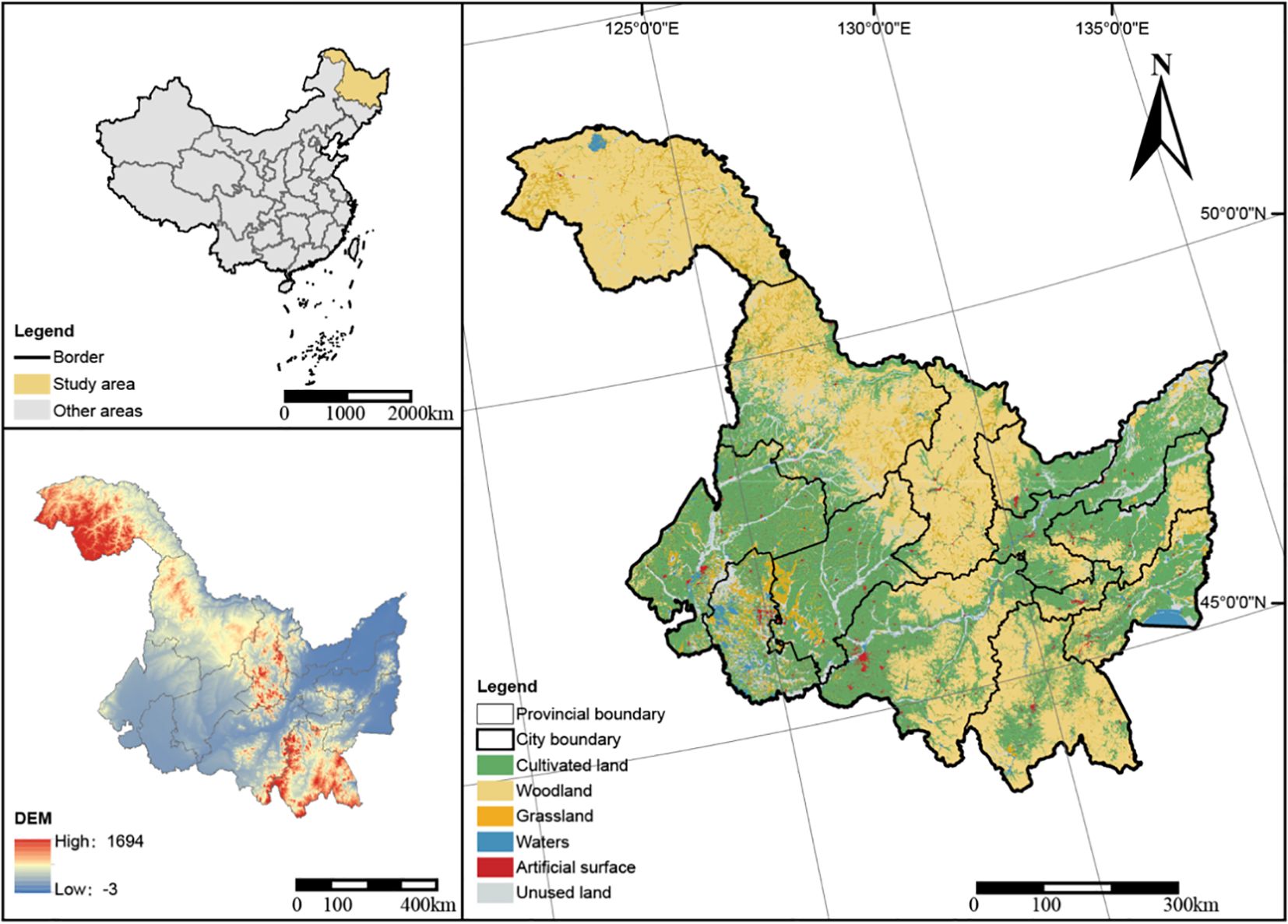
Figure 1. Location of the study area.
As China’s primary grain-producing region, the province comprises 12 prefecture-level cities and one prefectural-level division, crucially sustaining national food security. The Statistical Bulletin (2023) reports its 2023 grain output at 77.882 million tons, with rice (24.400 million tons), maize (43.790 million tons), and soybeans (9.278 million tons) collectively constituting 11% of China’s total output (Heilongjiang Provincial Bureau of Statistics and National Bureau of Statistics Survey Office in Heilongjiang, 2024). Rapid socio-economic development and urbanization have recently compelled the region to confront complex conflicts amidst expanding production spaces, increasing living spaces, and shrinking ecological spaces—all during sustained grain production (Xue and Ma, 2022). These contradictions intensify the imbalance between resource utilization efficiency and ecological integrity, necessitating scientific investigation of PLE spatial evolution patterns to guide optimized land allocation and ecological conservation.
2.2 Data sources
This study utilizes land-use remote sensing data (2000, 2010, 2020) for Heilongjiang Province. The 30-m resolution raster data were obtained from the Resource and Environment Science and Data Center (RESDC), Chinese Academy of Sciences (Resource and Environment Science and Data Center and Chinese Academy of Sciences, 2024). Administrative boundaries, provided without modification by China’s Ministry of Natural Resources (Ministry of Natural Resources of the People’s Republic of China, 2024), conform to the GS(2019)3333 and GS(2023)2763 mapping standards. All spatial data were uniformly projected to the WGS 1984 Albers Equal Area Conic projection. Data processing and analysis employed ArcGIS 10.4 and Origin 9.1.
3 Research methods
3.1 Classification system and evaluation index construction for PLE spaces
Production-living-ecological (PLE) spaces constitute integrated systems where land primarily serves dominant functions while supporting secondary functions (Zhang et al., 2015; Xue and Ma, 2022). Based on functional differences, land is classified into three types: production (e.g., cropland, industrial/mining areas for agriculture/operations), living (urban/rural settlements supporting human habitation), and ecological lands (forests, grasslands, wetlands, water bodies providing ecosystem services and environmental stability) (Cui et al., 2018).
China’s State Council (General Office of the State Council of the People's Republic of China, 2024) emphasized in the “Opinions on Implementing the Great Food View and Building a Diversified Food Supply System” that grain security encompasses production, ecological, and social dimensions. In major grain-producing areas, land-use functions directly impact national grain security and ecological security goals. Proper management of PLE land interrelationships is fundamental to achieving sustainable regional development.
This study adapts methodologies from Li and Fang (2016), Liu et al. (2017), and Cui et al. (2018)—specifically tailored to Heilongjiang—to quantitatively evaluate land functions (Zhang et al., 2015). For assessment consistency, each land category was classified into six grades by functional intensity and coherence. Production lands, for example, are graded: strong (5 points), relatively strong (4 points), semi-production (3 points), relatively weak (2 points), weak (1 point), and non-functional (0 points). We applied identical grading principles to living/ecological functions, assigning dominant functions based on highest scores (ties resolved by dominant physical attributes). Scoring prioritizes the intensity and functional irreplaceability of dominant land-use functions. Key criteria include:
1. Production function: Paddy fields (5 points): Epitomize peak agricultural production due to maximum yield/unit area and capital/labor inputs. Drylands (4 points): Core production zones with 10-20% lower mean yield stability than paddies (based on provincial yield statistics 2000-2020).
2. Living function: Urban areas (5 points): Maximize settlement-supporting capacity through dense populations and integrated infrastructure. Industrial/transportation lands (2 points): Support economic activities but lack residential suitability.
3. Ecological function: Forests (5 points): Provide irreplaceable water/biodiversity conservation and carbon sequestration services. Low-coverage grasslands (2 points): Offer limited ecological services with 40-60% lower resilience than forests (per NDVI stability analysis).
4. We normalized functional scores to enable cross-spatial and cross-categorical comparisons. Based on Heilongjiang’s current land-use patterns, this classification system captures major grain-producing area characteristics while embodying multifunctional land use principles. As detailed in Table 1, land types were systematically categorized and scored to establish the core dataset for subsequent analysis.
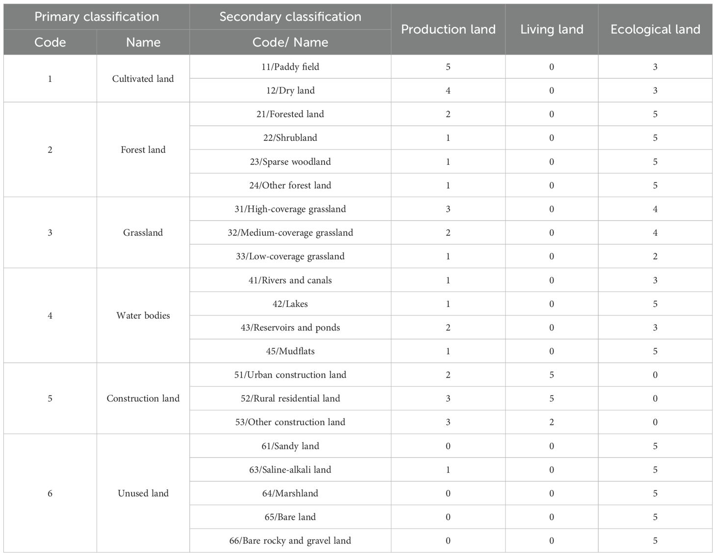
Table 1. Land use classification system and scoring in Heilongjiang Province based on the "production-living-ecological " space.
3.2 Analytical methods for spatiotemporal evolution of PLE spaces
We constructed a 3-km resolution grid using ArcGIS 10.4 to analyze the spatiotemporal evolution of PLE spaces in Heilongjiang Province. After assigning functional scores to land-use types, spatial overlay and min-max standardization generated PLE distribution maps for 2000, 2010, and 2020. Moran’s I index measured spatial autocorrelation of PLE functions to quantify clustering characteristics and temporal trends (Zhou and Cheng, 2015; Xu et al., 2024; Yin et al., 2024). Additionally, Local Indicators of Spatial Association (LISA) identified high-high (HH) and low-low (LL) clusters, revealing PLE spatial distribution patterns and evolutionary trajectories across periods.
3.3 Construction and analysis of land-use transfer matrix for PLE spaces
To further reveal the dynamic changes in land areas of Production-Living-Ecological (PLE) spaces within the grain-producing region, this study employed a land-use transfer matrix to quantitatively analyze the directions and magnitudes of land type transitions in Heilongjiang Province during two periods: 2000–2010 and 2010-2020. As a crucial tool in systemic analysis, the land-use transfer matrix accurately describes the mutual transformation relationships among different land categories and visually reflects the evolutionary processes of PLE spatial patterns over time (Xie et al., 2024). Using ArcGIS software to extract land-use data and Excel pivot tables to construct transfer matrices, the calculation is expressed by Equation (1):
Where i represents the initial land-use type, j denotes the terminal land-use type, and Sij indicates the land area transitioning from type i to type j. The symbol n denotes the total number of land-use types. Thus, the row sum represents the total land area of a specific type at the initial stage, while the column sum represents the total land area at the final stage.
3.4 Construction and calculation method of coupling coordination models for PLE spaces
To investigate the synergistic dynamics of production-living-ecological (PLE) functions in Heilongjiang Province, we developed an integrated coupling coordination model (Cong, 2019; Sui et al., 2020; Lei et al., 2024) with complementary pairwise submodels. We further traced spatiotemporal evolution through coupling coordination gravity migration analysis.
3.4.1 Integrated PLE coupling coordination model
This framework quantifies multi-dimensional interactions among production, living, and ecological functions, which are formally expressed in Equations (2–4):
The coupling degree C quantifies interaction intensity among production-living-ecological (PLE) functions, while Pi, Ri, and Ei denote region i’s production, living, and ecological function indices respectively. The comprehensive coordination index T reflects overall PLE synergistic development, with weighting coefficients α, β, and γ assigned equal values of 1/3 based on functional equivalence in grain-producing systems (Sui et al., 2020; Lei et al., 2024; Xu et al., 2024).
The classification of coupling coordination degrees directly affects the judgment of regional development status. Currently, the equal interval method or threshold method is widely adopted in academia for classification (Wang and Tang, 2018; Yu et al., 2025). We establish five distinct tiers: [0, 0.2) severe imbalance, [0.2, 0.5) mild coordination, [0.5, 0.6) moderate coordination, [0.6, 0.8) high coordination, and [0.8, 1.0] excellent coordination. This framework delineates explicit coordination thresholds while capturing transitional states from conflict to synergy, enabling precise tracking of spatial functional evolution.
3.4.2 Pairwise PLE coupling coordination analysis
Beyond the integrated PLE coordination model, we established specialized pairwise coupling frameworks to dissect nuanced interactions within functional dyads—production-ecological, production-living, and ecological-living systems (Wang and Tang, 2018; Luo et al., 2023). Weighting coefficients were calibrated to reflect intrinsic functional priorities: the production-ecological model assigned α = 0.55 and γ = 0.45, the production-living model utilized balanced weights α = 0.5 and β = 0.5, while the living-ecological model employed β = 0.55 and γ = 0.45. These targeted formulations overcome limitations of aggregate models by capturing asymmetric subsystem dynamics crucial for grain-producing systems, where production-ecological tensions often dominate spatial conflicts yet living-ecological synergies underpin long-term resilience.
3.4.3 Center-of-gravity shift analysis based on coupling coordination degree
Departing from conventional gravity models that focus on individual PLE functions, this study employs coupling coordination degree (D) as the mass attribute for spatial units. This approach tracks spatiotemporal shifts in systemic functional synergy, mapping migration pathways of integrated coordination states. Gravity centers for 2000, 2010, and 2020 were computed using D-values to analyze spatial distribution patterns and displacement trajectories (Lin et al., 2019; Zhou et al., 2024). The coordinates of the gravity center are calculated as shown in Equations (5, 6):
Where Xc and Yc denote gravity center coordinates, xi and yi represent the geographic centroid of grid cell i; and Di indicates the coupling coordination degree at cell i.
Using GIS, we mapped the gravity center positions for 2000, 2010, and 2020 with displacement trajectories, quantitatively revealing dynamic evolutionary characteristics of Production-Living-Ecological (PLE) spatial coordination in major grain-producing areas.
4 Results and analysis
4.1 Spatiotemporal evolution characteristics of PLE spaces
4.1.1 Temporal variation characteristics
Production space showed a continuous expansion trend. Specifically, the area of production space increased from 160,284.43 km² in 2000 to 163,910.28 km² in 2020, representing a net increase of 3,625.85 km² over the past 20 years.
Living space experienced a “rise-followed-by-decline” trend, reflecting phased fluctuations under urbanization. The area of living space rose from 8,570.38 km² in 2000 to 9,239.48 km² in 2010, then decreased to 8,930.86 km² in 2020, resulting in a net increase of 360.48 km² over the past 20 years.
Ecological space showed a continuous declining trend. The area of ecological space decreased from 283,546.01 km² in 2000 to 279,530.40 km² in 2020, a net reduction of 4,015.61 km² (Figure 2).
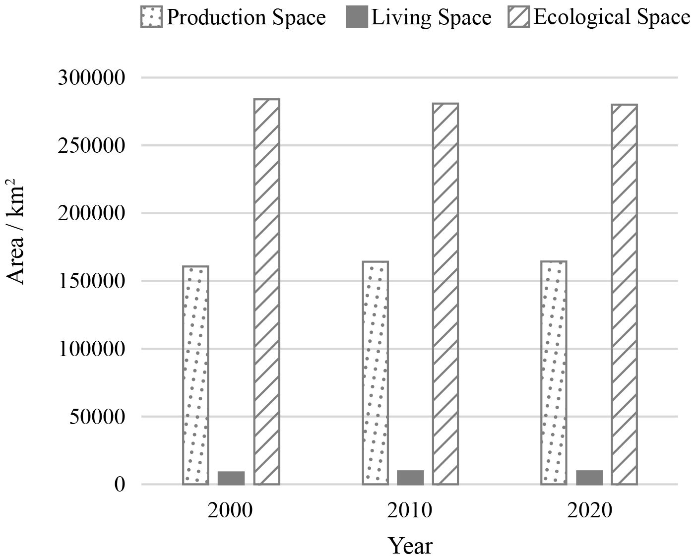
Figure 2. Changes in the area of “Production–Living–Ecological Spaces” in Heilongjiang Province from 2000 to 2020.
The production function score of land use in Heilongjiang Province increased from 1.17×10⁶ to 1.19×10⁶. The living function score rose from 4.33×10⁴ to 4.58×10⁴. The ecological function score slightly declined, from 1.85×10⁶ to 1.84×10⁶ (Figure 3).
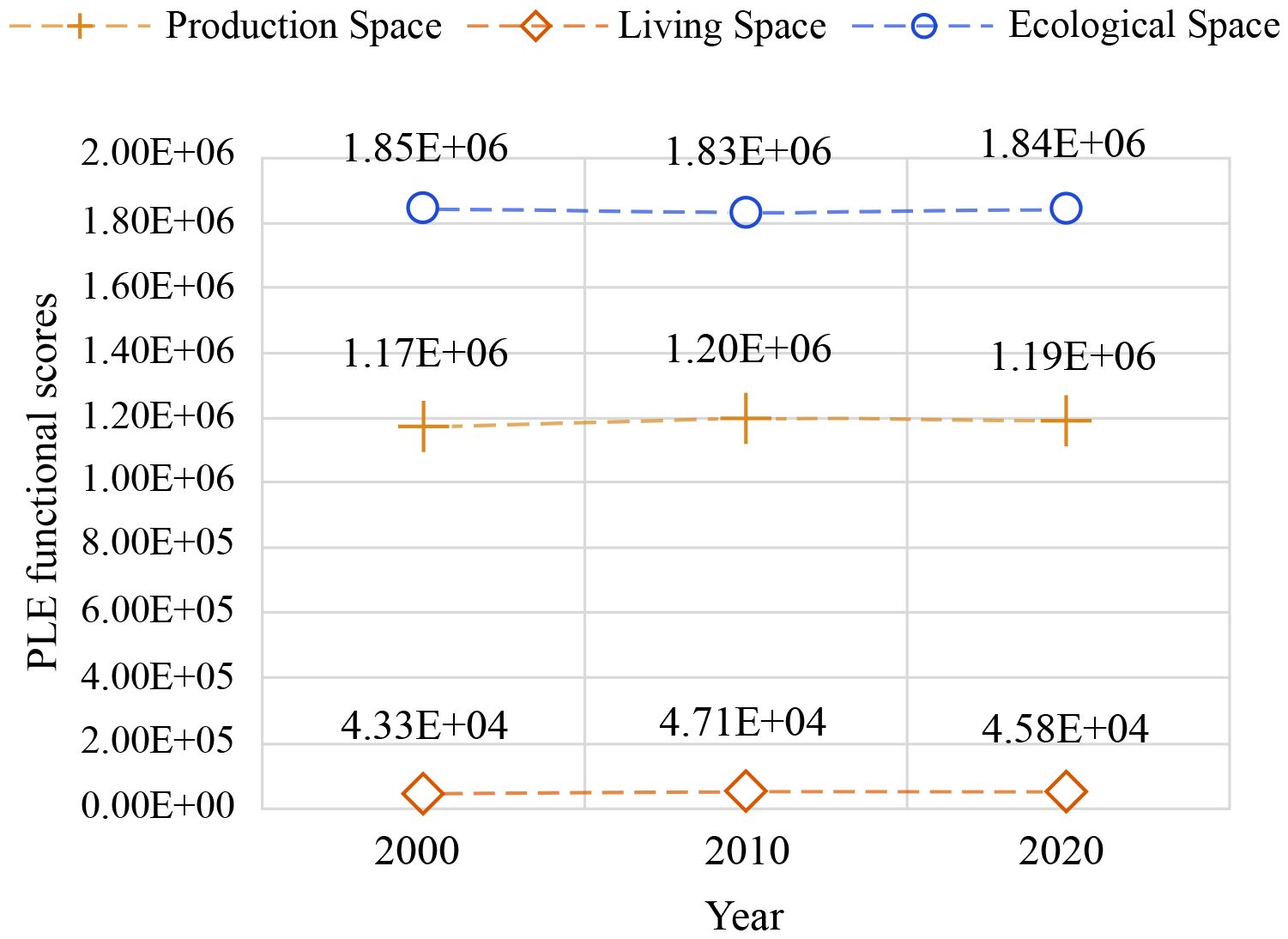
Figure 3. Temporal distribution of functional scores of Production-Living-Ecological (PLE) spaces in Heilongjiang Province (2000–2020).
Based on these temporal variations, ecological space and ecological function of land use in Heilongjiang’s major grain-producing areas not only support the production of grain and various agricultural products but also serve as crucial guarantees for constructing a green ecological living environment. Their health and stability directly influence regional agricultural sustainability and residents’ quality of life.
4.1.2 Spatial variation characteristics
Using ArcGIS zonal statistics and spatial overlay analysis, we observed significant spatial differentiation and dynamic evolution in Heilongjiang’s Production-Living-Ecological (PLE) patterns from 2000 to 2020.
High-value production function areas predominantly concentrated in the Songnen and Sanjiang Plains – core grain-producing regions with abundant land resources and prominent agricultural capacities (Figure 4). These core zones maintained stable spatial aggregation over 20 years, though peripheral areas experienced slight functional weakening due to urban expansion.
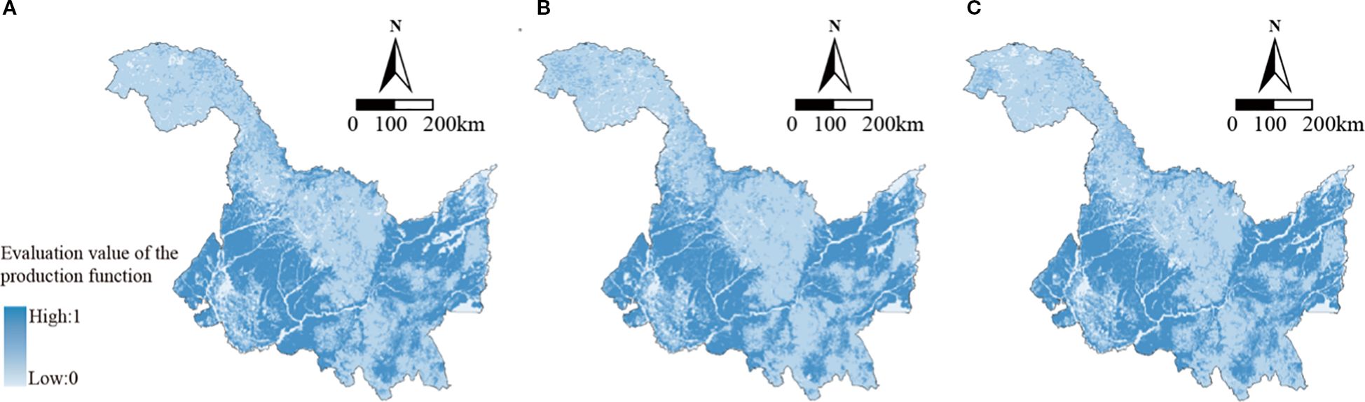
Figure 4. Spatial distribution of production space use patterns in Heilongjiang Province, 2000–2020.
Living function spaces expanded radially from central cities, primarily around Harbin, Qiqihar, and Daqing metropolitan zones (Figure 5). Higher population density and developed infrastructure enhanced living functions, with western regions showing faster expansion and superior functionality than eastern areas, correlating with economic development and population distribution.

Figure 5. Spatial distribution of living space use patterns in Heilongjiang Province, 2000–2020.
Ecological function spaces clustered in the Greater Khingan, Lesser Khingan, and Wandashan Mountains – regions with strong ecological regulation capacities despite challenging topography (Figure 6). While the overall ecological pattern remained stable, central urban peripheries witnessed encroachment and functional degradation.
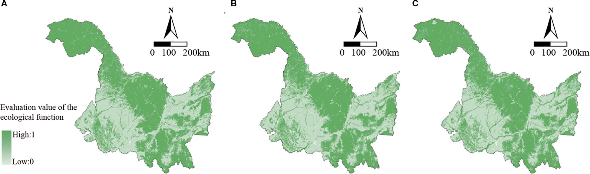
Figure 6. Spatial distribution of ecological space use patterns in Heilongjiang Province, 2000–2020.
In summary, the spatial dynamics of Heilongjiang’s PLE system revealed three co-occurring processes: production space consolidation predominantly concentrated in agricultural core zones like the Songnen and Sanjiang Plains demonstrated functional stability; concurrently, living space expansion radiated outward from urban centers under intensifying urbanization pressures, particularly around major metropolitan areas; meanwhile, ecological space experienced pronounced fragmentation near development zones, though functional stability persisted in remote mountainous regions acting as ecological strongholds.
4.2 Analysis of spatial aggregation characteristics of PLE spaces
Analysis of Moran’s I index and Local Indicators of Spatial Association (LISA) cluster analysis reveals that the production-living-ecological (PLE) spaces in Heilongjiang Province between 2000 and 2020 exhibited significant spatial agglomeration. However, the intensity of this agglomeration and its evolutionary trajectory varied considerably across different functional spaces (Table 2).
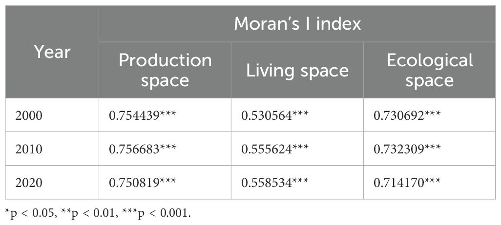
Table 2. Changes in global Moran’s I Index for " production-living-ecological spaces " in Heilongjiang province from 2000 to 2020.
The Moran’s I index for production space demonstrated relatively minor fluctuations throughout the period. It rose from 0.754439 in 2000 to 0.756683 in 2010, before experiencing a slight decline to 0.750819 in 2020. This trend indicates that while the spatial agglomeration of production functions remained robust, it experienced a subtle weakening over time. High-value agglomeration (H-H zones) were predominantly situated in the Songnen Plain and Sanjiang Plain, regions recognized for their extensive agricultural resources and advanced mechanized farming practices, thereby establishing them as Heilongjiang’s primary grain-producing hubs. Conversely, low-value agglomeration (L-L zones) were concentrated in the Greater Khingan Range to the north and the wetland fringe areas to the south. These locations are characterized by challenging geographical conditions and stringent ecological protection regulations, resulting in comparatively less pronounced production functions (Figure 7).

Figure 7. LISA cluster types of production space in Heilongjiang Province, 2000–2020.
The agglomeration patterns of living space exhibited a more consistent evolution. The Moran’s I index for living space increased from 0.530564 in 2000 to 0.558534 in 2020, indicating a gradual upward trend and a moderate enhancement in spatial concentration (Table 2). High-value agglomeration areas (H-H zones) were primarily clustered in major urban centers such as Harbin, Qiqihar, and Daqing, as well as their adjacent vicinities. This distribution underscores the intensifying influence of urbanization on the development of living spaces. Areas at the urban expansion fringe displayed a high-low agglomeration (H-L zone), while rural regions, characterized by weaker living space functions, presented as low-value agglomeration (L-L zones) (Figure 8).
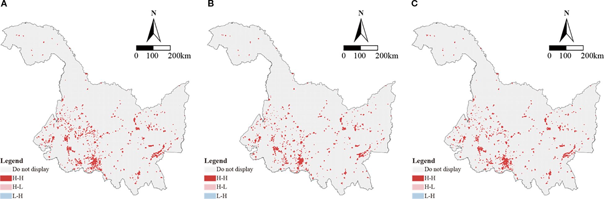
Figure 8. LISA cluster types of living space in Heilongjiang Province, 2000–2020.
The Moran’s I index for ecological space initially increased from 0.730692 in 2000 to 0.732309 in 2010. However, it subsequently decreased to 0.714170 by 2020 (Table 2), suggesting a trend towards weakening spatial agglomeration and increasing dispersion. High-value agglomeration areas (H-H zones) were mainly located in the Greater Khingan Range, Lesser Khingan Range, and designated wetland protection areas within the Sanjiang Plain. These concentrations are attributed to the implementation of strict ecological protection policies and favorable natural topography. In contrast, low-value agglomeration areas (L-L zones) were observed in the intensively farmed Songnen Plain and in regions undergoing urban expansion. This pattern reflects the considerable pressure exerted on ecological spaces by the encroachment of living and production activities, leading to a reduction in ecological connectivity (Figure 9).
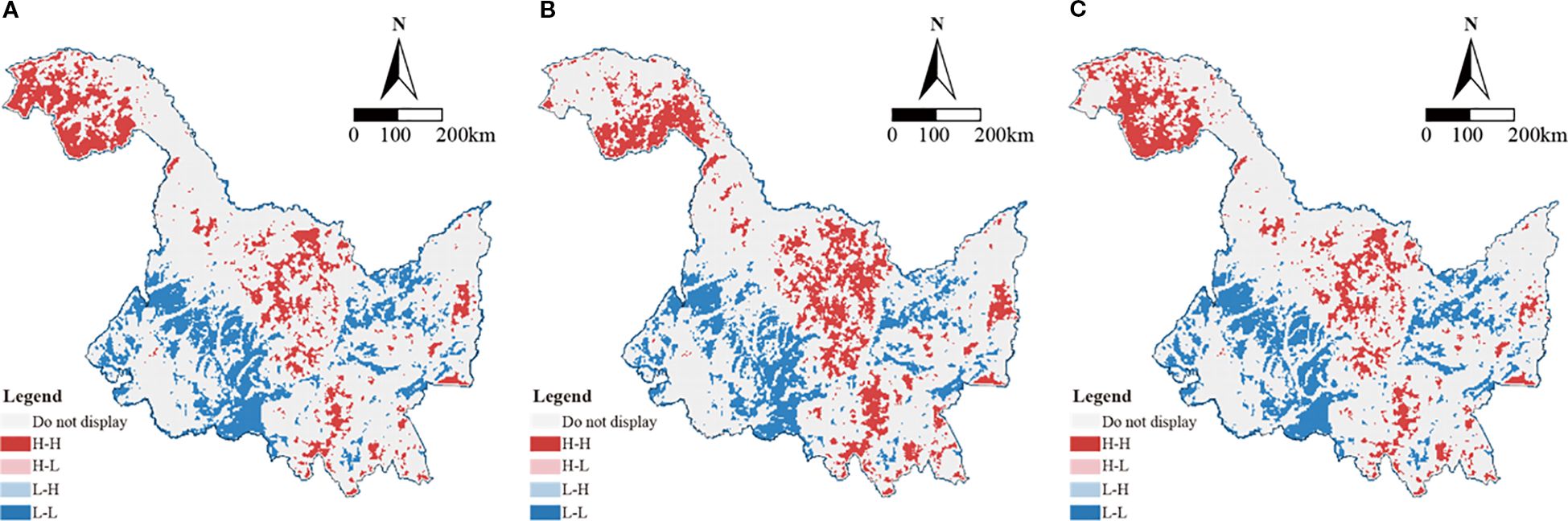
Figure 9. LISA cluster types of ecological space in Heilongjiang Province, 2000–2020.
4.3 Analysis of structural transition of land-use in PLE spaces
From 2000 to 2020, significant dynamic shifts occurred in the structure of the production-living-ecological (PLE) spaces in Heilongjiang Province, with functional flows between production, living, and ecological spaces exhibiting divergent trends and spatial distribution characteristics.
Analysis of land use data revealed that production space continued to expand (Figure 10), primarily concentrating in areas with high agricultural development intensity, such as core agricultural regions around Harbin and Qiqihar, and the Sanjiang Plain. The expansion of production space was largely a conversion from ecological space (Figure 11), a phenomenon particularly pronounced in the central Songnen Plain and the southeastern Sanjiang Plain, characterized by contiguous expansion of cultivated land. This reflects the dual drivers of enhanced agricultural functions and urban development on production space.
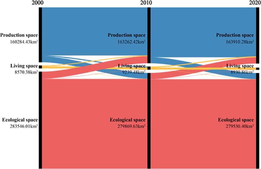
Figure 10. Sankey diagram of "Production-Living-Ecological" land use changes in Heilongjiang Province, 2000–2020.
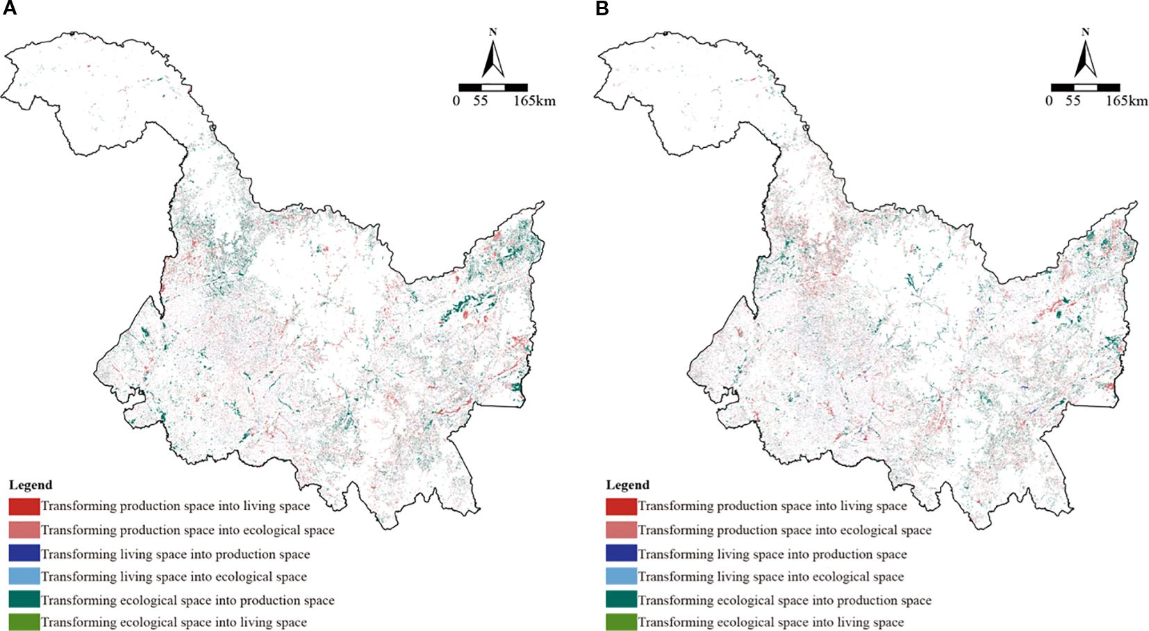
Figure 11. Spatial distribution of land use transitions among "Production-Living-Ecological" spaces in Heilongjiang Province, 2000–2020.
Living space, however, initially expanded before experiencing a decline (Figure 10). Spatially, the expansion of living space was concentrated in cities such as Harbin, Daqing, and Jiamusi, and their surrounding areas (Figure 11). The expansion of living space primarily originated from the transfer of ecological space, a trend that was more evident between 2000 and 2010, manifesting as the gradual replacement of ecological land with living and construction land around urban peripheries.
The changes in ecological space were the most significant, with a net decrease of 4015.61 km² over the 20-year period (Figure 10). Areas from which ecological space was transferred were mainly concentrated in regions with high intensity of agricultural development and urban expansion, particularly in the central-southern Songnen Plain and the eastern Sanjiang Plain (Figure 11). In these areas, the conversion of ecological functional land, such as wetlands and forests, into production space (e.g., cultivated land) and living space (e.g., urban and rural construction land) was evident. The conversion of ecological space to production and living space occurred in both phases, but it was more pronounced between 2010 and 2020, indicating limited policy intervention effectiveness and continued pressure on ecological space.
From the perspective of temporal and spatial characteristics, the structure of Heilongjiang Province’s “three spaces” underwent a continuous evolution from ecological to production and living functions between 2000 and 2020. Specifically, the structural changes were relatively gradual during the 2000–2010 period, with the transfer from ecological to living space being dominant. In contrast, during the 2010–2020 period, the rate of transfer from ecological to production space accelerated, while living space exhibited a complex pattern of coexisting contraction and outward expansion. This trend is primarily driven by multiple factors such as regional economic development, urbanization processes, and agricultural expansion, reflecting the long-term risk of ecological space being squeezed during the restructuring of “three spaces.”
4.4 Analysis of coupling coordination degree of PLE spaces
4.4.1 Overall spatiotemporal evolution of coupling coordination degree
Based on the analysis of the functions of the production-living-ecological spaces within each geographical grid between 2000 and 2020, the coupling coordination degree of these spaces in Heilongjiang Province exhibits distinct spatial differentiation characteristics.
From an overall perspective, areas with high coordination are predominantly concentrated in the central and southern regions of the Songnen Plain and the Sanjiang Plain. These areas are primarily agricultural, with production space taking precedence. Intense agricultural activity coexists with concentrated living spaces that possess well-developed infrastructure, forming a pattern of highly integrated production and living spaces.
Moderately and weakly coordinated areas are widely distributed across most of the province, representing the dominant type of coupling coordination degree in Heilongjiang. In contrast, areas with low or even disordered coordination are mainly situated in the northern Greater Xing’an Mountains, Lesser Xing’an Mountains, and the southeastern Wandashan region. In these areas, ecological space prevails, and production and living spaces are noticeably insufficient, resulting in poorer integration of the production-living-ecological spaces and overall lower coordination levels.
In terms of temporal evolution, from 2000 to 2020, the coupling coordination degree of the production-living-ecological spaces in Heilongjiang Province generally demonstrated a slow upward trend, with coordination levels gradually improving (Figure 12). Between 2000 and 2010, the number of moderately and highly coordinated areas progressively increased, and the coordination pattern remained relatively stable. During the 2010–2020 period, the trend of improvement became more pronounced, particularly in agricultural regions such as the Songnen Plain and Sanjiang Plain, where highly coordinated areas expanded further. Concurrently, coordination levels in the northern and eastern regions, characterized by dominant ecological functions, remained relatively stable, exhibiting no significant fluctuations. This indicates the relative lag in the integration of production-living-ecological spaces within ecologically dominant areas.
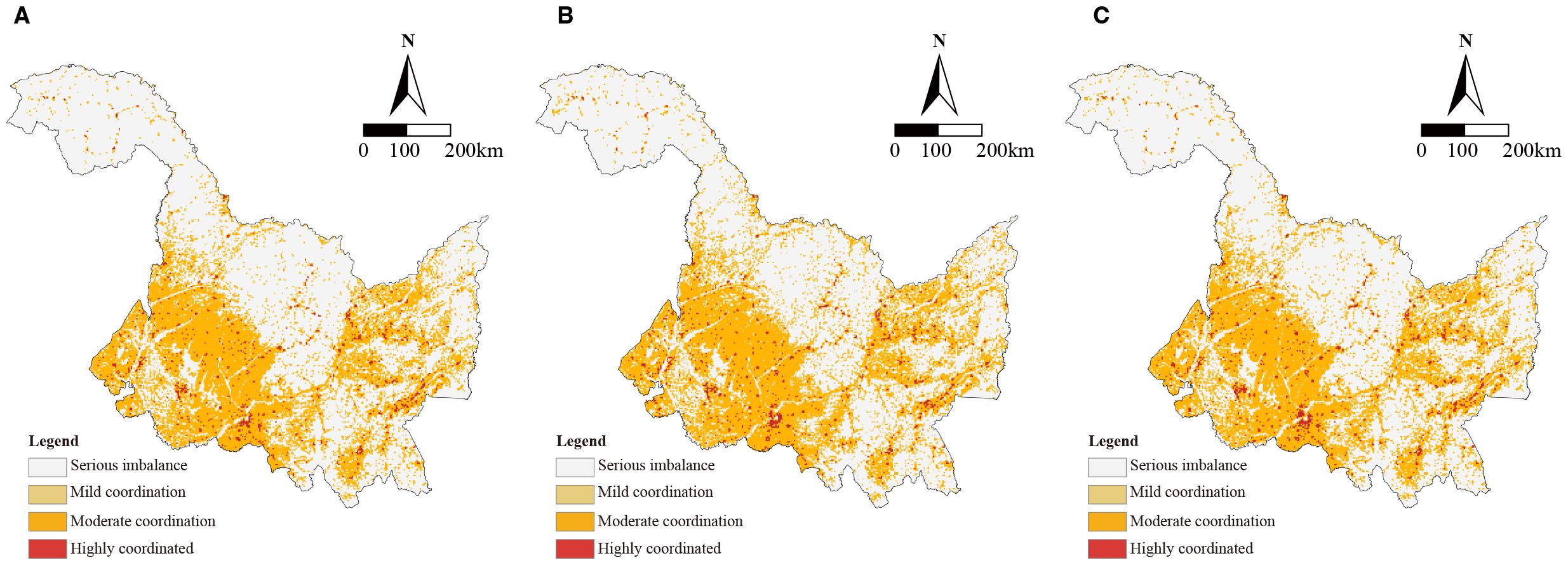
Figure 12. Spatial distribution of coupling coordination degree of "Production-Living-Ecological" spaces in Heilongjiang Province, 2000–2020.
4.4.2 Evolution characteristics of pairwise coupling coordination degrees among PLE functions
To further elucidate the coupling coordination relationships among the functions of the production-living-ecological spaces, this study analyzes the evolutionary characteristics of three pairwise coupling coordination degrees: production–living, production–ecology, and living–ecology. Following the classification standards for coupling coordination degrees, the proportions of different level intervals for each year were calculated, and the evolution curves of the pairwise coupling coordination degrees for the production-living-ecological spaces in Heilongjiang Province in 2000, 2010, and 2020 were fitted (Figure 13).
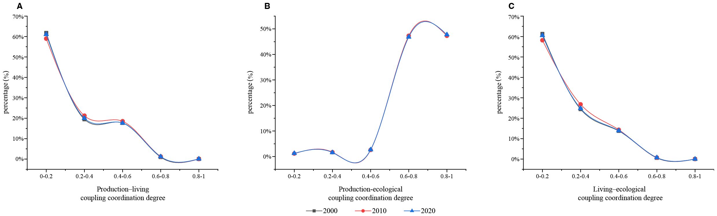
Figure 13. Evolution curves of pairwise coupling coordination degrees among "Production-Living-Ecological" spaces in Heilongjiang Province, 2000–2020.
The production–living space coupling coordination degree exhibited the lowest overall level (Figure 13A). From 2000 to 2020, it was predominantly concentrated in low-level intervals (0–0.2 and 0.2–0.4). Although there was a slight increase in high-level intervals in 2010 and 2020, the overall change was limited. This suggests that the functional integration between living and production spaces remains weak, necessitating a strengthening of their spatial coordination.
The production–ecology space coupling coordination degree was the highest (Figure 13B), predominantly falling within the intervals of 0.6–0.8 and 0.8–1. This indicates a steady enhancement in the synergy between agricultural production and ecological protection in Heilongjiang Province, leading to the gradual formation of an ecological agricultural pattern.
The living–ecology space coupling coordination degree was at a moderate level (Figure 13C). While it was primarily in low-level intervals in 2000, high-level intervals had increased by 2020. Overall, the coupling coordination degree remained low, reflecting the need for further spatial integration of urban and rural living functions with ecological functions to improve the green living environment.
The pairwise coupling coordination relationships among the production-living-ecological spaces in Heilongjiang Province demonstrate significant structural differences. The highest production–ecology coupling coordination degree reflects a robust synergy between agricultural production and ecological protection, serving as the core driving force for the efficient integration of these spaces in major grain-producing areas. The living–ecology space coupling coordination degree was predominantly at a low level, indicating that living functions in urban and rural areas and ecological space require gradual achievement of coordinated coexistence. The production–living space coupling coordination degree remained relatively low, characterized by weak spatial functional integration, highlighting the urgent need to optimize land use structure and improve infrastructure to further promote their coordinated spatial development.
4.4.3 Migration trends of center of gravity of production-living-ecological spaces coupling coordination degree
To further quantify and dynamicize the spatial synergistic effects of production-living-ecological spaces, this study employs a barycenter migration model of coupling coordination degree. The temporal evolution of the barycenter of this coordination was analyzed for Heilongjiang Province between 2000 and 2020. The results reveal a phased characteristic of the overall barycenter, exhibiting a pattern of initial northward migration followed by a subsequent southward shift (Figure 14).
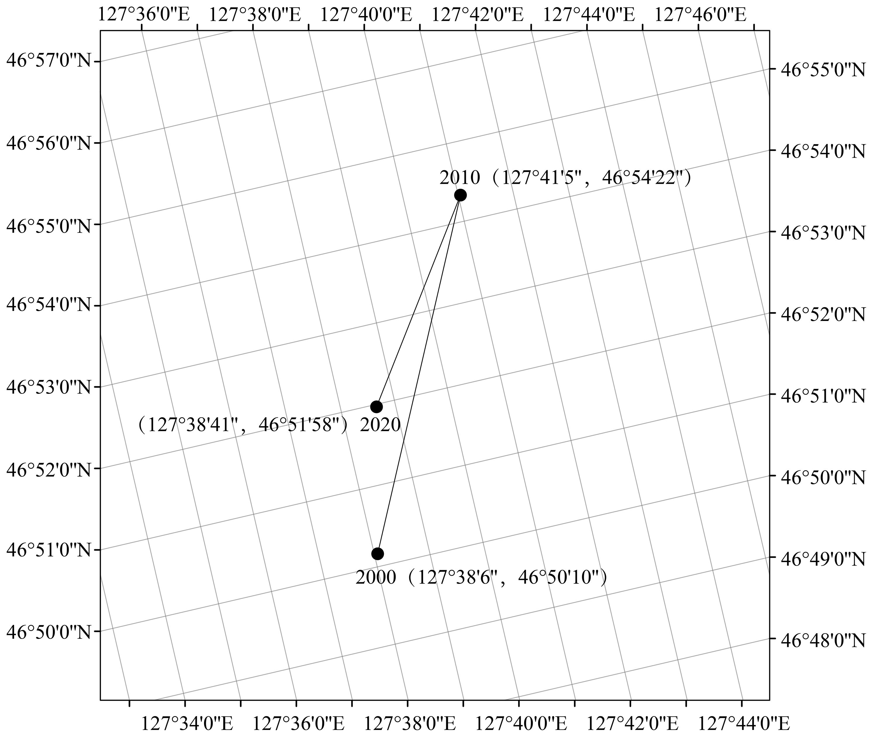
Figure 14. The center of gravity of migration of coupling coordination degree for "Production-Living-Ecological" spaces in Heilongjiang Province, 2000–2020.
During the period of 2000–2010, the barycenter of coupling coordination degree migrated from (127°38’6”E, 46°50’10”N) to (127°41’5”E, 46°54’22”N). This represented an overall eastward and northward displacement of approximately 8.64 kilometers, averaging 0.86 kilometers per year. This movement indicates a significant enhancement in coupling coordination degree within the northern regions during this phase. Such improvement can likely be attributed to the initial efficacy of ecological protection policies and the sustained stability of ecologically functional advantage zones.
Subsequently, from 2010 to 2020, the barycenter experienced a southwestward regression to (127°38’41”E, 46°51’58”N), covering a migration distance of approximately 5.38 kilometers. The magnitude of this migration was notably less than that of the preceding period. This suggests that while coordination degrees in southern agricultural areas, such as the Songnen Plain, saw improvement, the dominant influence of the northern regions on the barycenter’s position persisted.
In summation, the trajectory of the barycenter’s migration illustrates a dynamic process wherein the coupling coordination pattern of production-living-ecological spaces initially optimized from south to north before undergoing a slight southward adjustment. This evolution mirrors the changing regional coordination within Heilongjiang Province as it navigated advancements in ecological protection, agricultural development, and urbanization. Furthermore, this trend underscores that the spatial competition between production and ecological spaces continues to be a critical constraint on the enhancement of overall coupling coordination.
5 Discussion
This study reveals a profound intrinsic trade-off inherent in the evolution of the “Production-Living-Ecological Spaces” (PLES) in Heilongjiang Province. While previous research has predominantly highlighted the expansionary trend of production spaces in major grain-producing regions (Li and Fang, 2016; Meng et al., 2022; Li et al., 2023; Zhou et al., 2024), this study, through meticulous delineation of land use transition pathways, further demonstrates that such expansion has primarily occurred at the expense of ecological spaces within core agricultural areas, notably the Songnen Plain and Sanjiang Plain. This finding establishes a direct link between the macro-level national food security strategy and micro-level land use changes, clearly identifying a typical “eco-space-for-production” model prevalent in local practices. Although this model has effectively supported grain yields in the short term, our coupled coordination degree analysis also warns that it is undermining the long-term resilience of regional ecosystems, representing a core risk to regional sustainable development identified herein.
The tension between production and ecology outlined above is deeply rooted in the traditional “grain-only approach”. In contrast, the “Big Food Vision” proposed by the Chinese government (General Office of the State Council, 2024) provides a novel theoretical perspective and solution. The essence of this approach lies in transcending the traditional concept equating “food” solely with “grain,” expanding food sources from reliance on cultivated land alone to encompass the entire territorial space (including forests, grasslands, and water bodies), thereby constructing a diversified food supply system. This theory aptly explains a key finding of this study: the persistent suboptimal functional coupling between “production” and “living” functions in Heilongjiang Province is largely attributable to the high degree of fixation of the production function on cultivated land, while the considerable economic potential inherent in vast ecological spaces (e.g., forest land, wetlands) remains largely untapped. This profoundly reveals that excessive dependence on the output from a single land type (cultivated land) not only encroaches upon ecological space but also proven ineffective in driving diversified development and enhancing resident well-being in rural areas.
The findings of this study also engage effectively with existing research while advancing it further. For instance, while Mao and Jia (2022) noted the intensifying landscape fragmentation of regional agricultural and forestry land, our research, from a functional coupling perspective, uncovers the underlying functional root cause of this spatial fragmentation—namely, the lack of synergistic effects resulting from the simplification of land functions. Concurrently, Li et al. (2025) emphasize that future improvements in land habitat quality depend on strict ecological protection. This study provides a crucial supplement to this view: sole reliance on “passive protection” may prove unsustainable; greater emphasis needs to be placed on “proactive integration” guided by the “ Big Food Vision.” This entails developing eco-friendly industries to endogenously transform ecological advantages into economic benefits, thereby fundamentally alleviating the long-standing conflict between conservation and development. This paradigm shift from “protection” to “integration” represents the core concept that this study seeks to advocate at both theoretical and policy levels.
Building upon the preceding discussion, optimizing the “Production-Living-Ecological Space” (PLES) pattern in Heilongjiang Province necessitates a suite of systematic strategies that integrate regional characteristics with a global perspective. At the regional level, differentiated spatial governance should be implemented. In the Songnen Plain, where conflicts between production and ecology are acute, the establishment of integrated “farmland-ecological corridor” systems is required, coupled with the linkage of ecological compensation mechanisms to incentives for major grain-producing areas. In rural areas exhibiting weak production-living coupling, beyond utilizing the “Diversified Food Systems” concept to guide industrial development and foster new formats like eco-agriculture, understory economy, and rural tourism, further optimization of the land use structure is essential. This optimization should prioritize the promotion of scaled development among agricultural operators to achieve the in-situ integration of production and living functions. Here, ‘scaled development’ specifically emphasizes achieving a ‘functional moderate scale’. This logic operates through three mechanisms: 1) Enhancement of production efficiency and specialization: The consolidation of fragmented farmland into relatively concentrated operational units can significantly improve land use efficiency, providing the foundation for the adoption of advanced agricultural machinery and the dissemination of efficient production technologies; 2) Strengthening of livelihood support capacity: Moderate expansion of operational scale can generate stronger economic agglomeration effects, accumulating more funds for infrastructure development (e.g., roads, water supply, networks) and public services (e.g., education, healthcare) in rural areas; 3) Promotion of synergistic integration of production and living spaces: Once agricultural production reaches a certain scale with enhanced efficiency, its surplus products, by-products, or generated ecosystem services (e.g., environmentally friendly farming practices) can be more effectively converted into economic income and resources for improving the livelihoods of rural residents.
More significantly, the Heilongjiang case offers universal policy insights for other major global grain-producing regions—such as the US Corn Belt or Brazil’s Cerrado savanna, which face similar pressures of agricultural expansion and ecological degradation (Foley, 2005). The core lies in shifting land use from “single-function maximization” towards “multifunctional synergistic optimization”. Globally applicable strategies include: 1) Implementation of Nature-based Solutions (NbS), embedding ecological infrastructure within agricultural landscapes to enhance systemic resilience; 2) Establishment of policy frameworks capable of accounting for Ecosystem Service Value (ESV), making the contributions of ecological conservation “visible” in economic decision-making; 3) Promotion of diversified food systems to address the dual risks of global climate change and market volatility. These strategies collectively point towards a sustainable future: safeguarding global food supply while maintaining the ecological health and community prosperity of critical agricultural regions.
It should be noted that while the macro-scale trends and spatial patterns revealed by this study, based on 30m resolution remote sensing data, are clear, the resolution may mask micro-scale land function variations and dynamic changes to some extent. Future research could refine the understanding of functional evolution and synergistic optimization mechanisms at the village level by integrating higher-resolution data or field surveys.
6 Conclusion
This study systematically elucidates the spatiotemporal evolution patterns and coupling coordination characteristics of the “Production-Living-Ecological Space” (PLES) in Heilongjiang Province—a representative major grain-producing area in China—during the 2000–2020 period. The principal findings are summarized as follows:
1. Pattern Evolution and Intrinsic Trade-offs: Production space has undergone continuous expansion at the expense of critical ecological spaces, intensifying functional tensions between these two domains. Concurrently, living space demonstrates distinct enclave-style growth around central urban cores, exhibiting insufficient spatial integration with extensive production areas.
2. Functional Coupling and Structural Imbalance: Significant structural disparities are observed in PLES coupling coordination levels, manifested through relatively high production-ecological coordination juxtaposed with persistently low production-living coordination. This structural imbalance constitutes a fundamental constraint on regional holistic development.
3. Gravity Shift and Dynamic Transition: The trajectory of coupling coordination gravity—characterized by initial northward displacement followed by southward migration—provides clear evidence of a historic transition in regional development dynamics, shifting from ecological conservation imperatives toward agricultural production dominance.
The core contribution of this research resides in its quantitative revelation of profound spatial-functional trade-offs within localized systems under national food security strategies, complemented by the innovative application of the “Big Food Vision” concept as a theoretical framework for reconciling PLES conflicts. Our findings underscore the imperative for a paradigm shift in land policies across grain-producing regions: transitioning from a singular yield-maximization orientation toward an integrated governance model that synergistically coordinates production, livelihood, and ecological functions. This investigation not only holds significant practical implications for China’s territorial spatial planning but also offers valuable empirical insights for achieving sustainable development objectives in global agricultural regions confronting analogous challenges.
Data availability statement
The original contributions presented in the study are included in the article/supplementary material. Further inquiries can be directed to the corresponding author.
Author contributions
SG: Funding acquisition, Conceptualization, Formal Analysis, Writing – review & editing, Methodology, Writing – original draft, Data curation, Visualization. YM: Writing – original draft, Investigation, Software, Supervision, Resources, Writing – review & editing, Project administration, Validation.
Funding
The author(s) declare financial support was received for the research and/or publication of this article. Strategic Priority Research Program of the Chinese Academy of Sciences (Grant No. XDA28070501).
Conflict of interest
The authors declare that the research was conducted in the absence of any commercial or financial relationships that could be construed as a potential conflict of interest.
Generative AI statement
The author(s) declare that no Generative AI was used in the creation of this manuscript.
Any alternative text (alt text) provided alongside figures in this article has been generated by Frontiers with the support of artificial intelligence and reasonable efforts have been made to ensure accuracy, including review by the authors wherever possible. If you identify any issues, please contact us.
Publisher’s note
All claims expressed in this article are solely those of the authors and do not necessarily represent those of their affiliated organizations, or those of the publisher, the editors and the reviewers. Any product that may be evaluated in this article, or claim that may be made by its manufacturer, is not guaranteed or endorsed by the publisher.
References
Aslam R. W., Shu H., Tariq A., Naz I., Ahmad M. N., Quddoos A., et al. (2024). Monitoring land use change in Uchhali and Khabeki wetland lakes, Pakistan using remote sensing data. Gondwana Res. 129, 252–267. doi: 10.1016/j.gr.2023.12.015
Assiri M., Barone V., Silvestri F., and Tassinari M. (2020). Planning sustainable development of local productive systems: A methodological approach for the analytical identification of Ecoregions. J. Cleaner Production 287, 125006. doi: 10.1016/j.jclepro.2020.125006
Bole Y., Rina S., Guga S., Na M., Fan S., and Zhang J.(2025). Evaluation of resources, environment, and ecological carrying capacity from the perspective of "production-living-ecology" spaces: A case study of western Jilin Province, China. J. Cleaner Production 491, 144770. doi: 10.1016/j.jclepro.2025.144770
Callesen G. M., Lundhede T. H., Olsen S. B., and Schou J. S. (2022). Socioeconomic effects of a bottom-up multifunctional land consolidation project. Land Use Policy 117, 106102. doi: 10.1016/j.landusepol.2022.106102
Cong X. (2019). Expression and mathematical property of coupling model, and its misuse in geographical science. Economic Geogr. 39, 18–25. doi: 10.15957/j.cnki.jjdl.2019.04.003
Cui J., Gu J., Sun J., and Luo J. (2018). The spatial pattern and evolution characteristics of the production, living and ecological space in Hubei Province. China Land Sci. 32, 67–73. doi: 10.11994/zgtdkx.20180723.121720
Du G., Sun X., and Wang J. (2016). Spatiotemporal patterns of multi-functionality of land use in Northeast China. Prog. Geogr. 35, 232–244. doi: 10.18306/dlkxjz.2016.02.010
Foley J. A. (2005). Global consequences of land use. Science 309, 570–574. doi: 10.1126/science.1111772, PMID: 16040698
Fu J., Gao Q., and Jiang D. (2022). Optimal regulation of spatial planning in the context of black soil preservation and food security in Qiqihar. Acta Geographica Sin. 77, 1662–1680. doi: 10.11821/dlxb202207007
Gazi M. Y., Haque I. M., Alam M. Z., and Uddin M. M. (2023). Spatiotemporal land use dynamics driven by socioeconomic context in the southwestern coastal districts of Bangladesh. Ocean Coast. Manage. 245, 106859. doi: 10.1016/j.ocecoaman.2023.106859
General Office of the State Council of the People's Republic of China (2024). Opinions on implementing the “Big Food Concept” to build a diversified food supply system. Available online at: https://www.gov.cn/zhengce/content/202409/content_6974838.htm (Accessed December 23, 2024).
Heilongjiang Provincial Bureau of Statistics and National Bureau of Statistics Survey Office in Heilongjiang (2024). Statistical bulletin of Heilongjiang Province on national economic and social development in 2023. Available online at: https://tjj.hlj.gov.cn/tjj/c106779/202406/c00_31742252.shtml (Accessed December 23, 2024).
Johansen P. H., Ejrnæs P., Kronvang B., Olsen J. V., Praestholm S., and Schou J. S. (2018). Pursuing collective impact: A novel indicator-based approach to assessment of shared measurements when planning for multifunctional land consolidation. Land Use Policy 73, 102–114. doi: 10.1016/j.landusepol.2018.01.040
Kangas K., Brown G., Kivinen M., Tolvanen A., Tuulentie S., Karhu J., et al. (2022). Land use synergies and conflicts identification in the framework of compatibility analyses and spatial assessment of ecological, socio-cultural and economic values. J. Environ. Manage. 316, 115174. doi: 10.1016/j.jenvman.2022.115174, PMID: 35658267
Kong D., Chen H., and Wu K. (2021). The evolution of "production-living-ecological" space, eco-environmental effects and its influencing factors in China. J. Natural Resour. 36, 1116–1135. doi: 10.31497/zrzyxb.20210503
Lei M., Jiang X., Wang R., Zheng Q., Liu H., and Cui Q. (2024). The coupling and coordination of "production-living-ecological" functions in shrinking cities in the Yellow River Basin. J. Northwest Univ. (Natural Sci. Edition) 54, 461–471. doi: 10.16152/j.cnki.xdxbzr.2024-03–011
Li G. and Fang C. (2016). Quantitative function identification and analysis of urban ecological-production-living spaces. Acta Geographica Sin. 71, 49–65. doi: 10.11821/dlxb201601004
Li Y., Zhang N., Zhang Y., Monika S., and Du G. (2025). Evolution in land-habitat quality in black soil area of Northeast China and multi-scenario forecasting: The study of Heilongjiang Province. Environ. Sci. doi: 10.13227/j.hjkx.202409094
Li Y., Zhao Y., Zhou Z., Cao M., and Huang Y. (2023). Analysis of ecological problems and its conservation-restoration strategy of mountains, rivers, forests, farmlands, lakes and grasslands in the Xiaoxing'an Mountains–Sanjiang Plain. Ecol. Sci. 42, 95–104. doi: 10.14108/j.cnki.1008-8873.2023.01.011
Lin Y., Zhao J., Zhang M., and Chen G. (2019). Identification of territory space pattern and spatio-temporal evolution analysis of urban agglomeration in Central Yunnan. Trans. Chin. Soc. Agric. Machinery 50, 176–191. doi: 10.6041/j.issn.1000-1298.2019.08.020
Liu J., Liu Y., and Li Y. (2017). Classification evaluation and spatial-temporal analysis of "production-living-ecological" spaces in China. Acta Geographica Sin. 72, 1290–1304. doi: 10.11821/dlxb201707013
Luo H., Wu Z., Gan Z., Chen J., He P., Chen Z., et al. (2023). Production-Living-Ecology“ function of main grain producing areas and sustainable development of food production. J. Agro-Forestry Economics Manage. 22, 671–681. doi: 10.16195/j.cnki.cn36-1328/f.2023.06.70
Luo H., Wu Z., Gan Z., Chen J., He P., and Chen Z. (2023). Spatial-temporal evolution characteristics of coupling coordination of “production-living-ecology“ space functions in the Pearl River Delta urban agglomeration. Sci. Soil Water Conserv. 21, 43–52. doi: 10.16843/j.sswc.2023.06.005
Machefer M., Zampieri M., Velde M. V. D., Dentener F., Claverie M., and D'Andrimont R. (2024). Earth observation based multi-scale analysis of crop diversity in the European Union: First insights for agro-environmental policies. Agriculture Ecosyst. Environ. 374, 109143. doi: 10.1016/j.agee.2024.109143
Mao L. and Jia J. (2022). Study on the change characteristics of landscape pattern of agricultural and forestry land at county area in Heilongjiang. For. Eng. 38, 44–53. doi: 10.16270/j.cnki.slgc.2022.02.020
Meng Y., Han X., Liu Q., Su D., and Sun X. (2022). Ecosystem pattern and composition with changes of Sanjiang Plain. Environ. Sci. Manage. 47, 151–155. doi: 10.3969/j.issn.1673-1212.2022.07.032
Ministry of Natural Resources of the People’s Republic of China (2024). Administrative boundary dataset of China. Available online at: https://www.mnr.gov.cn/ (Accessed December 23, 2024).
National Development and Reform Commission of the People's Republic of China (2008). Outline of National Medium- and Long-term Plan for Food Security (2008–2020). Available online at: https://www.gov.cn/jrzg/2008-11/13/content_1148414.htm (Accessed December 23, 2024).
Ni W., Xia Y., and Zhao N. (2022). Functional evolution and coupling coordination measurement of production-living-ecological space in rural areas: Taking Heilongjiang Province as an example. China Land Sci. 36, 111–119. doi: 10.11994/zgtdkx.20220901.094605
Pang L., Zhou X., and Wei L. (2021). Function evaluation and coupling coordination analysis of land space "productive-living-ecological" in Guangxi Zhuang Autonomous Region during 2009–2018. Bull. Soil Water Conserv. 41, 237–244. doi: 10.13961/j.cnki.stbctb.2021.01.033
People's Government of Heilongjiang Province (2024). General situation of Heilongjiang Province. Available online at: https://www.hlj.gov.cn/hlj/c108476/202005/c00_30550923.shtml (Accessed December 23, 2024).
Resource and Environment Science and Data Center and Chinese Academy of Sciences (2024). China’s land use dataset (2000–2020). Available online at: http://www.resdc.cn/ (Accessed December 23, 2024).
Salhi A., Benabdelouahab S., Bouayad E. O., Benabdelouahab T., Larifi I., Mousaoui M. E., et al. (2020). Impacts and social implications of land use-environment conflicts in a typical Mediterranean watershed. Sci. Total Environ. 764, 142853. doi: 10.1016/j.scitotenv.2020.142853, PMID: 33077206
Sheikh W. T. and van Ameijde J. (2022). Promoting livability through urban planning: A comprehensive framework based on the "theory of human needs. Cities. 131, 103972. doi: 10.1016/j.cities.2022.103972
Sui H., Song G., and Zhang H. (2020). Identification of production-living-ecological space at Keshan County level in main grain producing areas in northern Songnen Plain, China. Trans. Chin. Soc. Agric. Eng. 36, 264–271. doi: 10.11975/j.issn.1002-6819.2020.19.030
Tait J. (2001). Science, governance and multifunctionality of European agriculture. Outlook Agric. 30, 91–95. doi: 10.5367/000000001101293517
Wang C. and Tang N. (2018). Spatio-temporal characteristics and evolution of rural production-living-ecological space function coupling coordination in Chongqing Municipality. Geographical Res. 37, 1100–1114. doi: 10.11821/dlyj201806004
Wei W., Zhao L., Yin L., Xia J., and Bo L. (2024). Spatial-temporal evolution characteristics and influencing factors of territorial space in the Huaihe Eco-economic Belt from 1990 to 2020. Areal Res. Dev. 43, 12–19. doi: 10.3969/j.issn.1003-2363.2024.05.003
Xie M., Zhou H., Chen S., and Wang X. (2024). Spatiotemporal evolution of land use and its driving forces in Lüliang City of Shanxi Province. Bull. Soil Water Conserv. 44, 296–306. doi: 10.13961/j.cnki.stbctb.2024.03.030
Xu Z., Dong Y., and Yan Y. (2024). Spatial-temporal evolution and coupling coordination of production, living, ecological space (PLES) in Urumqi. Ecol. Sci. 43, 47–57. doi: 10.14108/j.cnki.1008-8873.2024.04.006
Xue X. and Ma L. (2022). Analysis on the coupling and coordination of land ecological and food security in main grain producing areas. Chin. J. Agric. Resour. Regional Plann. 43, 1–11. doi: 10.7621/cjarrp.1005-9121.20220901
Yin L., Wei W., Li H., Zhao L., Xia J., and Bo L. (2024). Characteristics, regional differences, and influencing factors of agricultural spatial evolution in China from 2000 to 2020. Geographical Res. 43, 1225–1246. doi: 10.11821/dlyj020230878
Yu T., Zhang Y., Jia S., and Cui X. (2025). Spatio-temporal evolution and drivers of coupling coordination between digital infrastructure and inclusive green growth: Evidence from the Yangtze River economic belt. J. Environ. Manage. 376, 124416. doi: 10.1016/j.jenvman.2025.124416, PMID: 39921956
Zhang H., Xu E., and Zhu H. (2015). An ecological-living-industrial land classification system and its spatial distribution in China. Resour. Sci. 37, 1332–1338. doi: CNKI:SUN:ZRZY.0.2015-07-004
Zhou L. and Cheng Y. (2015). Spatio-temporal pattern and its driving factors of grain production in Heilongjiang Province. J. Natural Resour. 30, 491–501. doi: 10.11849/zrzyxb.2015.03.012
Keywords: major grain-producing areas, production-living-ecological (PLE) spaces, Heilongjiang Province, spatiotemporal evolution, coupling coordination
Citation: Ge S and Ma Y (2025) Quantifying the spatio-temporal dynamics and coupling coordination of PLE spaces in Heilongjiang’s Grain Belt: a grid-based geospatial analysis. Front. Ecol. Evol. 13:1635979. doi: 10.3389/fevo.2025.1635979
Received: 29 May 2025; Accepted: 05 September 2025;
Published: 25 September 2025.
Edited by:
Peter Convey, British Antarctic Survey (BAS), United KingdomReviewed by:
Ye Wang, Hebei Normal University for Nationalities, ChinaJunan Xia, Wuhan University, China
Copyright © 2025 Ge and Ma. This is an open-access article distributed under the terms of the Creative Commons Attribution License (CC BY). The use, distribution or reproduction in other forums is permitted, provided the original author(s) and the copyright owner(s) are credited and that the original publication in this journal is cited, in accordance with accepted academic practice. No use, distribution or reproduction is permitted which does not comply with these terms.
*Correspondence: Yanji Ma, bWF5YW5qaUBpZ2EuYWMuY24=