 Le Zhang1,2Yu Lou3Jinhua Mei4
 Haipeng Wu1,2*Le Xia4
 Juan Dai5Yuping Dai1,2Guxiang Xu1,2Yuantao Yu1,2Jiehui Wang1,2
- 1School of Hydraulic and Ocean Engineering, Changsha University of Science & Technology, Changsha, China
- 2Key Laboratory of Dongting Lake Aquatic Eco-Environmental Control and Restoration of Hunan Province, Changsha, China
- 3Science and Technology Promotion Center Ministry of Water Resources P.R.C., Beijing, China
- 4Hunan Center of Natural Resources Affairs, Changsha, China
- 5Changjiang River Scientific Research Institute, Wuhan, China
Global damming of rivers strongly impacts the transport and characteristic of sediment, resulting in a significant reduction in the suspended sediment content (SSC) flowing into the downstream. The reduction in SSC may influence chlorophyll-a (Chl-a) concentrations in water, thereby further affecting the aquatic ecological environment. However, the effect of reduced SSC on Chl-a is poorly studied. Here, we compared and analyzed the distribution conditions of Chl-a in 6 representative years for both before the implementation of Three Gorges Dam (TGD) (BIT) and after the implementation of TGD (AIT), using the TM/OLI data and NIR-red inversion model. The findings showed that, from BIT to AIT, the area proportion of ultraoligotrophic state significantly decreased, while the area proportion of oligotrophic, mesotrophic, and eutrophic states significantly increased, with eutrophic state observed for the first time in 2017. Additionally, a significant correlation between Chl-a concentration and SSC was found. The area proportion of ultraoligotrophic state was positively correlated with SSC, while oligotrophic and mesotrophic states were negatively correlated with SSC. The reduction in SSC enhanced water promoting phytoplankton growth and consequently increasing Chl-a concentrations. This study highlights the spatiotemporal variations of Chl-a dynamics in DL before and after the operation of the TGD and discusses the impacts of SSC on water trophic states and the ecosystem. The findings provide valuable scientific insights for large-scale lake water quality monitoring and offer critical reference points for future water quality management strategies.
1 Introduction
Global damming of rivers significantly affects natural wetlands (Douterelo et al., 2009; Wu et al., 2019). As vital aquatic ecosystems, wetlands deliver indispensable ecological services to human communities while significantly contributing to biodiversity conservation and the stability and resilience of the global ecosystem (Wu et al., 2021; Zhang et al., 2014). The presence of dams disrupts sediment transport pathways and deposition processes, leading to a reduction in the sediment content flowing downstream. The suspended sediment content (SSC) is one of the crucial factors controlling the wetland ecological environment and plays an essential role in sustaining wetland ecosystem (Hou et al., 2024; Ganju et al., 2015).
Dongting Lake (DL) is the second freshwater lake in China, offers a wealth of freshwater and wetland resources (Yuan et al., 2021). In recent years, the hydrological conditions of DL have undergone significant changes due to the influence of the Three Gorges Dam (TGD). TGD significantly reduces the content of discharged sediment, especially suspended sediment (Kondolf et al., 2014), through mechanisms such as intercepting upstream sand, slowing down water flow to promote sediment settlement, and releasing clean water during regulation and storage (Yang et al., 2018). The operation of TGD effectively changed the sediment transport pattern of the Yangtze River, significantly reducing the sediment load in the middle and lower reaches and estuary areas (Gao et al., 2021; Tian et al., 2021; Zhang et al., 2025). The construction of TGD lead to the accumulation of a significant amount of suspended sediment in the upper reaches (Geng et al., 2021; Yang et al., 2018), consequently resulting in a reduction of SSC in the downstream rivers or lakes (Gardner et al., 2023; Kondolf et al., 2014; Syvitski et al., 2005). Many studies have demonstrated that SSC is closely associated with Chl-a dynamics in aquatic ecosystems. Chen et al. (2017) reported that the impoundment of the TGD has significantly influenced Chl-a dynamics in the Yangtze River estuary, primarily by reducing sediment loading and altering the spatial distribution of high Chl-a concentrations. Sediments are carriers of nutrients, and under different environmental conditions, nutrients can be adsorbed onto or released from particles (Coimbra et al., 2021). Especially under hypoxic or reducing conditions (Atique and An, 2020; Chen et al., 2017), the release of bound phosphorus from sediments may have a significant impact on eutrophication (Jiang et al., 2020). Meanwhile, reduced SSC has the potential to enhance light transmittance, which may prolong light exposure in the water and potentially influencing Chl-a concentration (Kallio et al., 2015; Liu et al., 2023; Xiao et al., 2023). Therefore, changes in SSC may directly or indirectly affect Chl-a concentration through light limitation and nutrient availability, thereby impact the water quality and ecological health of the lake (Heydari et al., 2024). Additionally, DL has a long hydraulic residence time, which favors the accumulation of nutrients and the growth of phytoplankton (Fan et al., 2024). Combined with the influence of SSC on light availability and nutrient transport, these conditions can exacerbate eutrophication and pose potential risks to water quality and ecological safety. As a crucial indicator, Chl-a is a pigment that exists in all algal species (Shen et al., 2022a), which can represent algal biomass and the extent of eutrophication (Ali et al., 2022). Therefore, this study provides valuable insights into eutrophication processes in lakes with long hydraulic residence times and varying sediment conditions, offering scientific guidance for lake water quality protection and ecological risk management.
Although the traditional Chl-a detection method has the advantage of high precision, the water quality information obtained is very scattered (Zhao et al., 2024). Insufficient field data is available for the majority of lakes worldwide because of the limitations in spatial coverage (Plisnier et al., 2023; Stanley et al., 2019). Satellite observations can provide a reference for monitoring water quality in a wide range of spatial and temporal dimensions (Cao et al., 2022), thus saving time and effort in high-frequency monitoring (Torres-Pérez et al., 2021). In the past several years, many researchers have begun to apply remote sensing on monitoring Chl-a concentration in lakes worldwide (Wang et al., 2018). For example, Shi et al. (2023) used the generalized additive model (GMA) to research the seasonal variation of Chl-a and the influence of transparency, TP, TN, conductivity and other factors on Chl-a in Wuliangsuhai Lake. Rodríguez-López et al. (2020) computed spectral indices via using Landsat images and built a novel regression model to evaluate the Chl-a concentration in Chilean Laja Lake. Consequently, remote sensing technology offers a more efficient and comprehensive tool for monitoring the spatiotemporal dynamics of Chl-a in aquatic ecosystems over large areas, enhancing our ability to provide robust and extensive monitoring data for these ecosystems.
Therefore, this study, using TM/OLI data and classical NIR-red model, compared the Chl-a concentration in DL before the implementation of TGD (BIT) and after the implementation of TGD (AIT) to investigate the impact of reduced SSC on Chl-a. The specific objectives are as following: (1) to investigate the impact of the decreasing of SSC on Chl-a; and (2) to provide references for water quality monitoring of lakes and the response to the changes of hydrological situation.
2 Study area and methods
2.1 Study area
DL (28°30′–29°38′ N, 112°18′–113°15′ E) is situated on the southern bank of the middle and lower reaches of the Yangtze River (Figure 1), encompassing a total area of approximately 2691km2 (Wu et al., 2015), is the second largest freshwater lake in China (Wu et al., 2020; Xiong et al., 2024). DL is among the most significant ecological wetland in the world (Wu et al., 2024), plays a pivotal role in the regulation of water resources, protection of ecological diversity and sustainability (Wu et al., 2019, 2017). The annual average SSC existed significant difference (p < 0.001) from BIT to AIT in DL, with the higher SSC of BIT than AIT (Figure 2). The annual average SSC of DL during 1991–2005 is 0.3078 kg/m3, and the annual average SSC during 2006–2021 is 0.0674 kg/m3 (Geng et al., 2024; YRWRC, 2007, 2008, 2009, 2010, 2011, 2012, 2013, 2014, 2015, 2016, 2017, 2018, 2019, 2020, 2021, 2022).
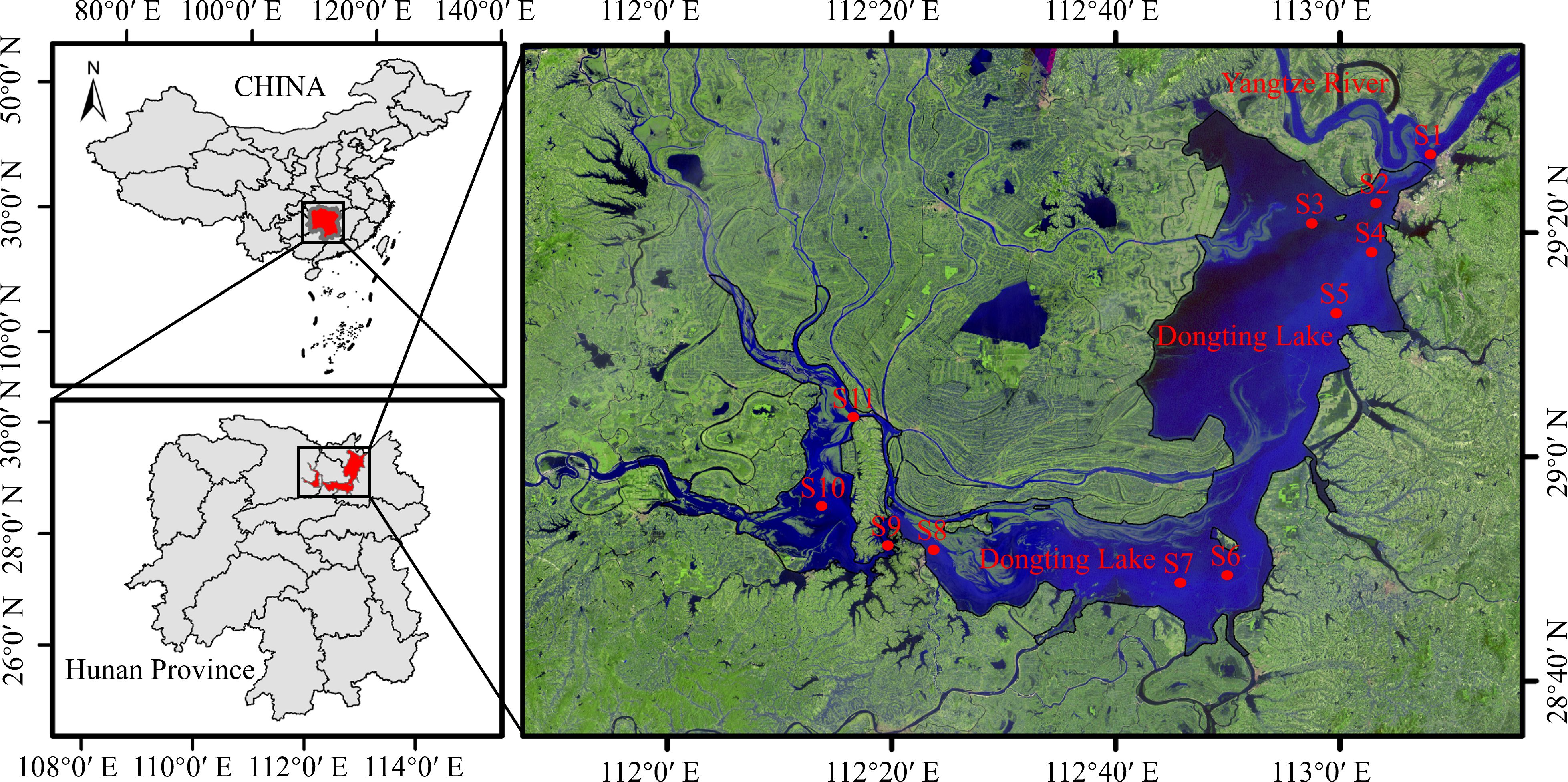
Figure 1. Location of Dongting Lake (DL) and the position of each hydrology stations.
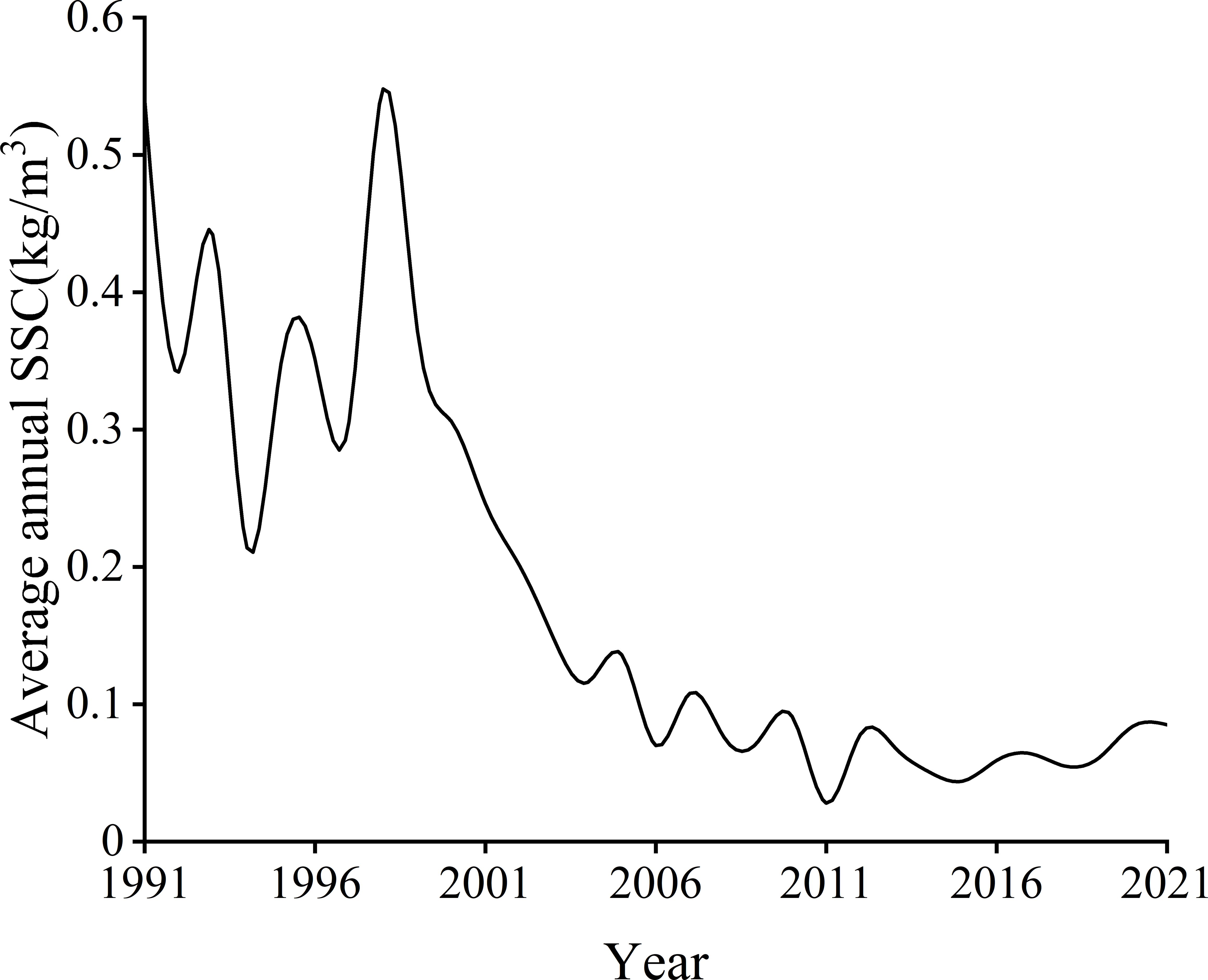
Figure 2. The average annual suspended sediment content (SSC) of DL during 1991 to 2021.
2.2 Datasets
Satellite images and existing hydrological data were utilized in our study. The satellite images from Landsat sensor and hydrologic data from DL Hydrology Station were employed in this study. Considering the availability of satellite images and the hydrological data, the satellite images from 2006, 2007, 2008, and 2009 (a total of 38 available samples from 11 sites) and data of chlorophyll-a (Chl-a) concentration were selected for establishing the Chl-a inversion model. The data sample points are shown in Figure 1. In addition, 1991, 1995, and 2000 year were chosen as the BIT’s representative. While 2010, 2011 and 2017 year were chosen as the AIT’s representative.
In this study, the satellite data, including TM and OLI of Landsat sensor, were downloaded from the website (http://www.usgs.gov/) of USGS and the data of suspended sediment was obtained from the Yangtze River Water Resources Commission (YRWRC, 2006, 2007, 2008, 2009, 2010, 2011, 2012, 2013, 2014, 2015, 2016, 2017, 2018, 2019, 2020, 2021, 2022) and Geng et al. (2024). The annual SSC of DL reaches its peak in flood season, that can best reflect its level of that year (Geng et al., 2022; Yu et al., 2018). Therefore, our study used satellite images of flood season in each year. To ensure the availability of satellite images, 12 scenes of Landsat images, listed in Supplementary Table S1, were specifically selected for Chl-a inversion.
2.3 Methods
2.3.1 Satellite image pretreatment and water extract
The preprocessing of satellite image contained Radiometric Calibration and Atmospheric Correction. Therefore, Radiometric Calibration module and the fast line of sight atmospheric analysis of spectral hypercubes (FLAASH) model in ENVI software (version 5.6) were utilized to achieve the preprocessing of remote sensing image. The water information derived from the normalized difference water index (NDWI) proposed by McFeeters (1996) is often contaminated with the buildup land noise, leading to an overestimation of the water area. To reduce or eliminate the effects of the noise, the modified NDWI (MNDWI) is used to extract the water area (Xu, 2006). The MNDWI is exhibited as shown in Equation 1:
where Green represents a green band and SWIR represents a shortwave infrared band.
2.3.2 Construction and accuracy verification of the Chl-a concentration inversion model
Our study employed the classical NIR-red model to establish a Chl-a concentration inversion model by using the measured Chl-a concentration data in monitoring stations of DL as the dependent variable and the remote sensing reflectance obtained after band ratio treatment as the independent variable (Brezonik et al., 2005; Poddar et al., 2019). Moreover, the measured data and band reflectance were subjected to Pearson correlation analysis, and the accuracy of the inversion model was further validated under the condition of significant correlation (p < 0.05).
To ensure the reliability of this study, the determination coefficient (R2), root mean square error (RMSE), mean relative error (MRE) and mean absolute error (MAE) were utilized to evaluate the inversion accuracy of the model. The aforementioned indicators are computed as shown in Equations 2–5:
where is the y value, is the inverse value of e, is the average of e, n is the number of samples, subscript i is the serial number of each sample point.
The final inversion model for Chl-a concentration in DL during the flood season will be determined based on its ability to meet the required level of inversion accuracy. If the current inversion model fails to meet this level of accuracy, an alternative satellite image will be selected and utilized to establish a new inversion model until the desired level of accuracy is achieved.
2.3.3 Classification of trophic state
If Chl-a concentration is used as the research standard, it can only reflect the change at a single point. Besides, the changes of Chl-a concentration across numerous adjacent points in a large area are complex and varied, making it challenging to quantify the overall dynamics of Chl-a in an extensive region. To address this issue, in this study, different Chl-a concentration ranges were categorized into distinct trophic states and analyzing the variations within each state to reveal the comprehensive Chl-a dynamics in DL (Rotta et al., 2021). The classification of trophic state was shown in Supplementary Table S2. According to the classification level, the inversion images were reclassified by ArcGIS software (version 10.7).
2.3.4 Applying landscape pattern indices and layer superposition
The landscape pattern indices which were used in this study were class metrics. The class metrics indices include percent of landscape (PLAND), largest patch index (LPI), aggregation index (AI) and landscape division index (DIVISION). The calculation of the aforementioned landscape pattern indices for DL were conducted by using Fragstats software (version 4.3). Additionally, the layer superposition method was utilized to explore changes in Chl-a concentration before and after reducing SSC in DL.
2.4 Data analysis
Linear regression analysis and ANOVA were employed to analyze the impact of reduced suspended sediment content on overall Chl-a concentration in DL. The analyses were finished utilizing SPSS software (version 27).
3 Results
3.1 Molel for inverting Chl-a concentration
A total of 38 remote sensing reflectance obtained from band processing were input into the inversion model to get access to the Chl-a estimation results, which were then compared with the measured data from these monitoring stations. The formula and indexes of the model are presented in Figure 3. The inversion error falls within an acceptable range (p < 0.001, R2 = 0.498, RMSE= 0.403 mg/m3, MRE=19.5%, MAE= 0.302 mg/m3), indicating that the model exhibits reliable Chl-a inversion performance to some extent during DL flood season.
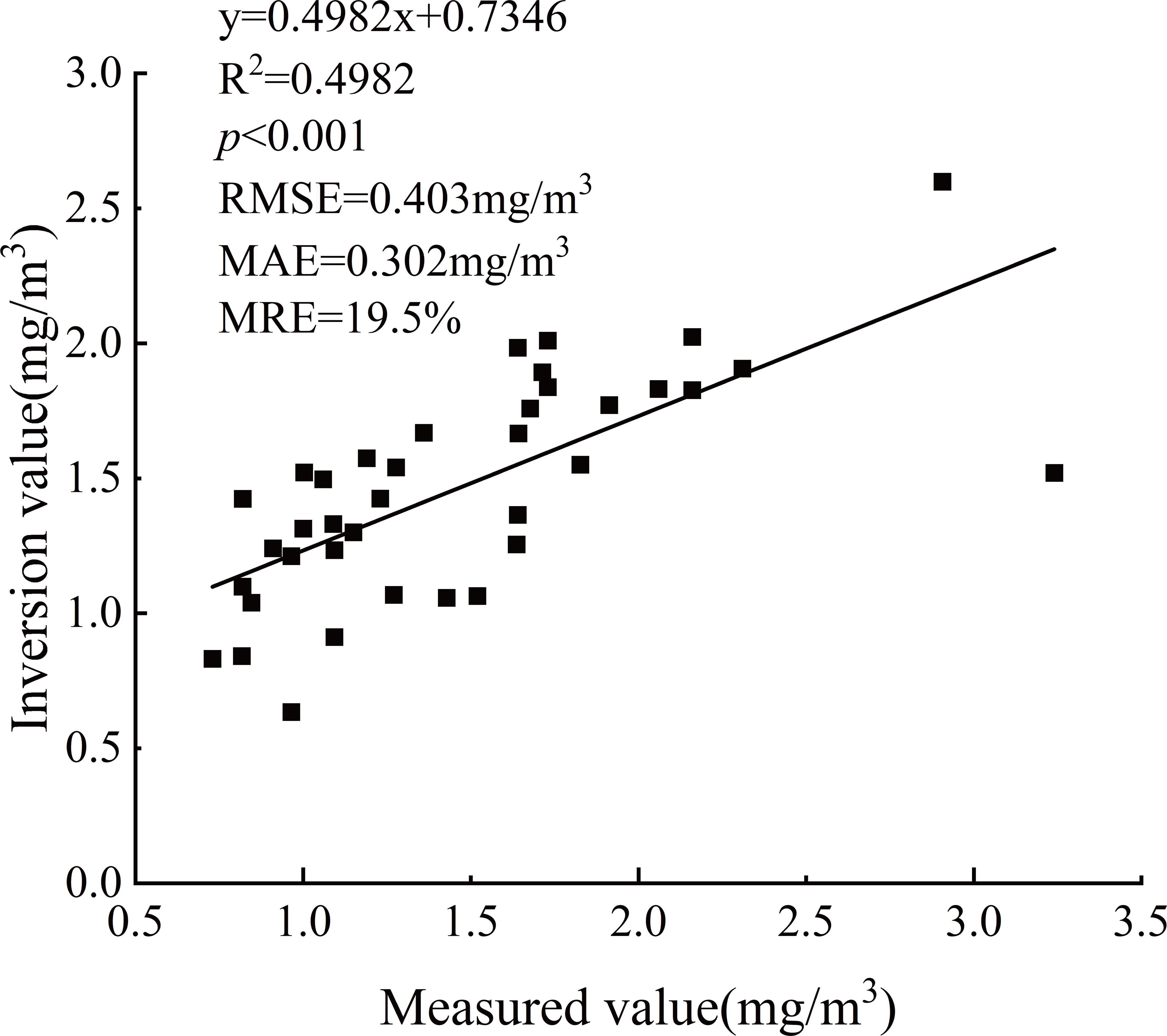
Figure 3. Scatter plot of measured and inversion values of Chl-a in DL.
3.2 The distribution and variation of Chl-a
Trophic state classification maps for each representative year were shown in Figure 4. The findings indicated that the Chl-a concentration was the highest in East DL, where ultraoligotrophic and oligotrophic states prevailed. In contrast, South and West DL exhibited lower Chl-a concentrations and were characterized primarily by ultraoligotrophic conditions. The average Chl-a concentrations in DL were 0.76, 0.89, and 1.25 μg/L during the BIY, and 1.65, 1.55, and 1.62 μg/L during the AIY, respectively. ANOVA results showed that the average Chl-a concentration in AIY was significantly higher than that in BIY (p < 0.05). Furthermore, the area proportion of each trophic state in every representative year was shown in Figure 5A. There was a significant difference in Chl-a concentration between BIT and AIT in DL. From BIT to AIT, the percentage of ultraoligotrophic area was significantly decreased (p < 0.05), decreasing from 76.49% to 31.58%, while the percentage of oligotrophic, mesotrophic and eutrophic area were significantly increased (p < 0.05), oligotrophic and mesotrophic states respectively rose from 23.08% and 0.43% to 62.87% and 5.35%, and the eutrophic state was only observed in 2017 of DL. Besides, layer superposition was utilized to reveal the changing trend of Chl-a concentration in DL and the result was shown in Figure 5B. The findings showed that, from BIT to AIT, the Chl-a concentration increased in most regions of East DL and South DL, but decreased in West DL. Generally, the Chl-a concentration in DL represented an increasing trend. In addition, the class metrics indices of the DL water with BIT and AIT were shown in Figure 6. From BIT to AIT, in DL, the reduction in SSC led to a significant difference (p < 0.05) of PLAND in every trophic states. Furthermore, the reduction in SSC also resulted in a significant decrease (p < 0.05) of LPI and AI of ultraoligotrophic state, a significant increase (p < 0.05) of LPI of oligotrophic state and a significant rise (p < 0.05) of DIVISION of ultraoligotrophic state. These changes in these indices suggested that the reduction in SSC has an obvious impact on the Chl-a concentration in DL.
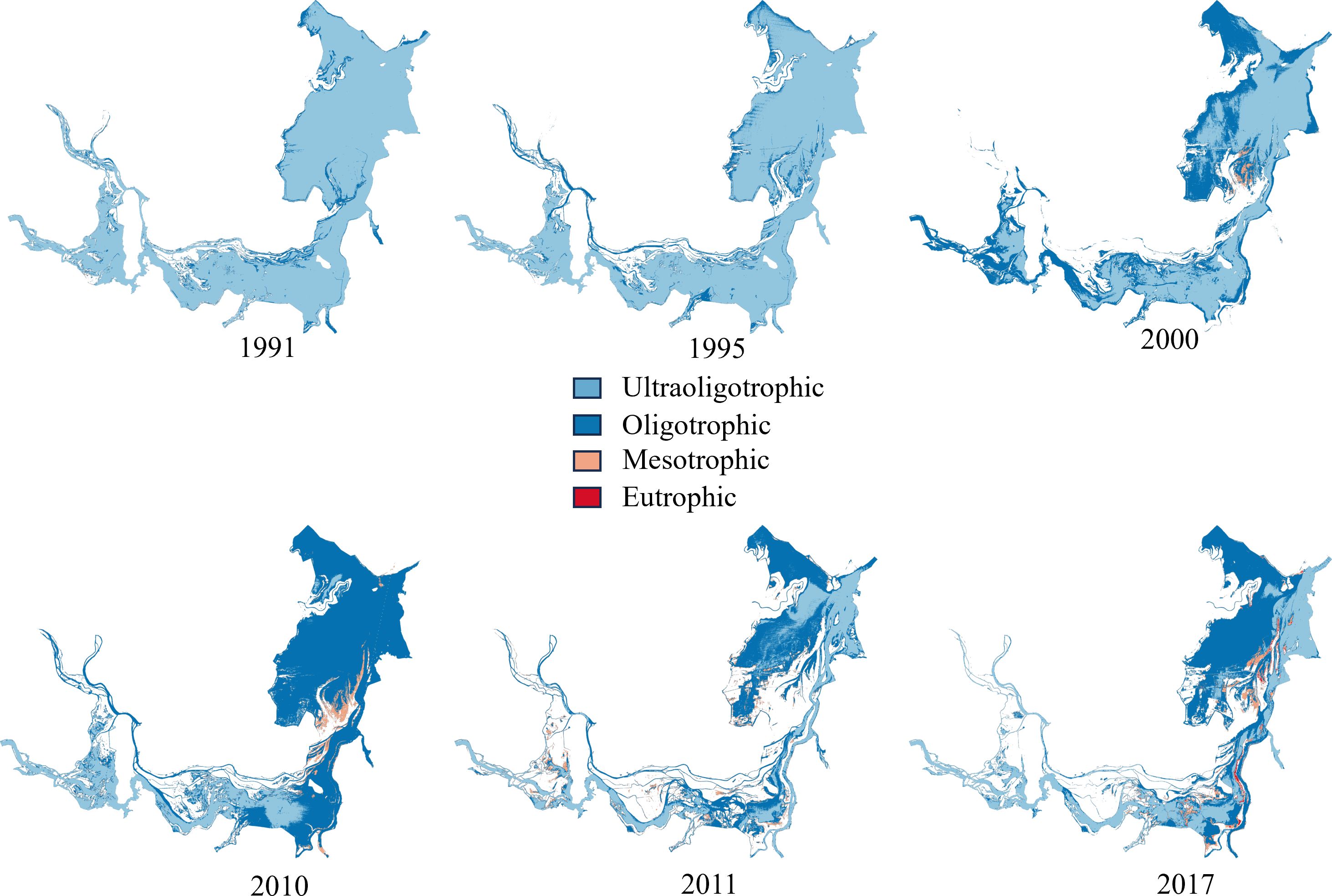
Figure 4. The distributions of each trophic state of before the implementation of TGD (BIT) and after the implementation of TGD (AIT) in DL during flood season.
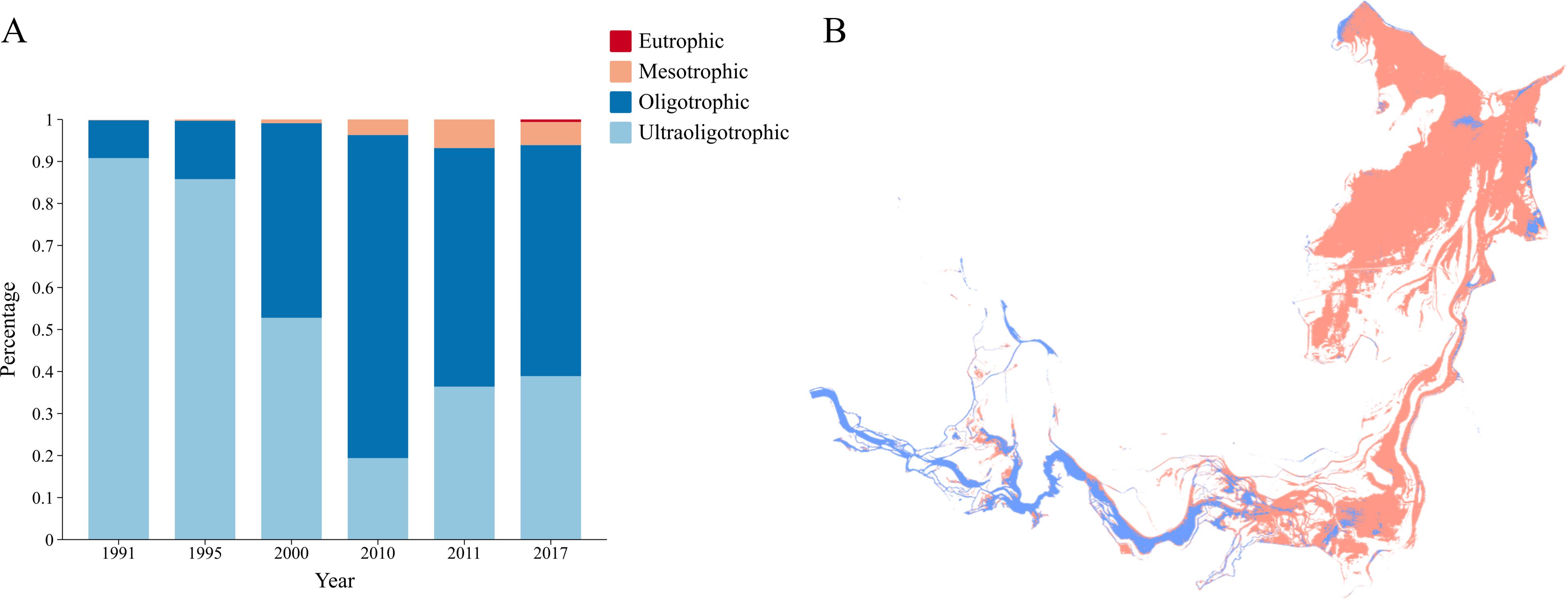
Figure 5. (A) The area proportion of each trophic state in every representative year. (B) The result of layer superposition, red represents an increase in Chl-a concentration and blue represents a decrease in Chl-a concentration.
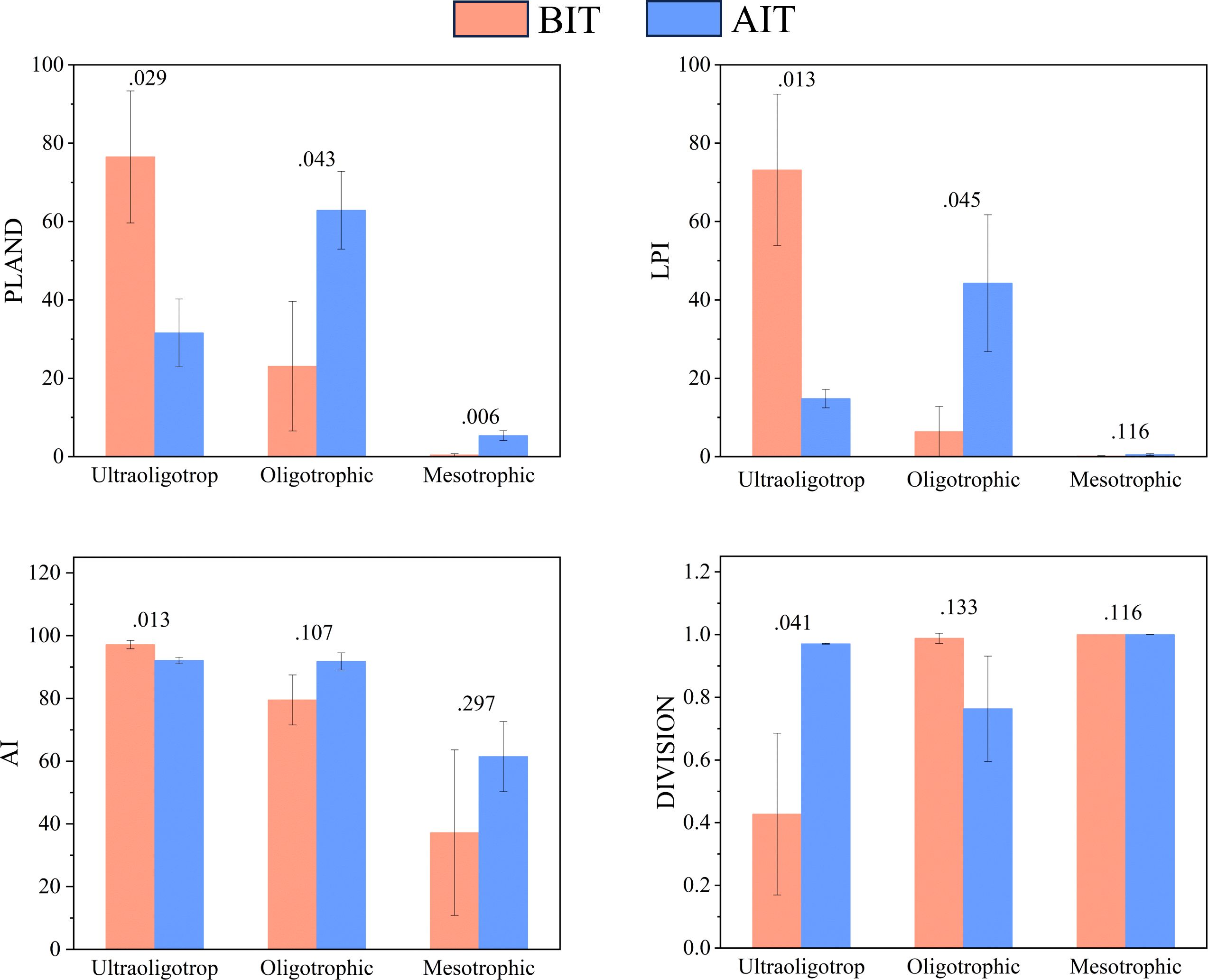
Figure 6. The class metrics indices (mean ± SD) of each trophic state for BIT and AIT in DL. P value of the difference between BIT and AIT are shown above the columns.
3.3 Relationship between Chl-a and SSC
Linear regression analysis was utilized to reveal the relationship between Chl-a and SSC (Figure 7). Notably, we found that there is a close interaction between Chl-a and SSC. The area proportion of ultraoligotrophic state was positively correlated with SSC (R2 = 0.8827, p < 0.01), while oligotrophic (R2 = 0.8322, p < 0.05) and mesotrophic (R2 = 0.8414, p < 0.01) states were negatively correlated with SSC. Consequently, the recent rise in Chl-a concentration in DL was likely attributable to the reduction in SSC. In addition, the average concentration of Chl-a was significantly negatively correlated with SSC (r = -0.953, p < 0.01).
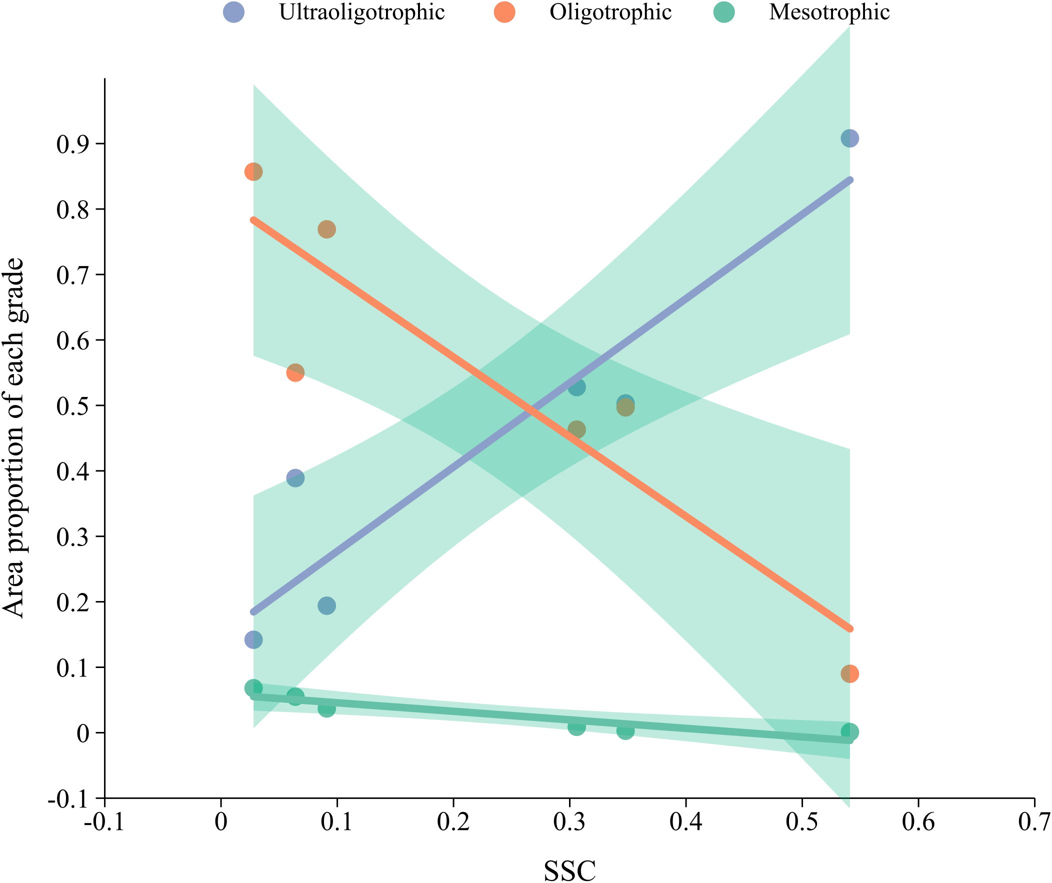
Figure 7. The results of linear regression analysis of the trophic state and SSC.
4 Discussion
4.1 Performance of the Chl-a inversion model
Due to the varying water environmental characteristics of different lakes, the study bands differ accordingly. Dall’Olmo and Gitelson (2006) recommended adjusting the spectral band positions to identify the most suitable band for the specific study area. The NIR-red model holds significant potential for estimating Chl-a (Gurlin et al., 2011). The NIR-red model is employed and the parameter indexes indicated that the NIR-red model demonstrated excellent performance in estimating Chl-a concentrations during the flood season in DL (p < 0.001, R2 = 0.498, RMSE= 0.403 mg/m3, MRE=19.5%, MAE= 0.302 mg/m3). This band combination is suitable for Chl-a monitoring in DL, likely due to the sensitivity of infrared and near-infrared bands to changes in light absorption and scattering by phytoplankton under the water quality conditions of DL. Consequently, the remote sensing reflectance data from these bands can effectively capture the correlation between Chl-a concentrations and relevant spectral features (Tran et al., 2023; Wang et al., 2023a). The stability of the model revealed the significant potential of remote sensing technology for sustained and large-scale water quality monitoring in lakes.
4.2 Impacts of SSC on Chl-a
Driven of economic development and human activities, eutrophication and massive algal growth seriously threaten many lakes (Duan et al., 2024), rivers (Tian et al., 2024), and reservoirs (Gao et al., 2018). Sediments are important carriers of nutrients, and their adsorption and release are regulated by environmental conditions (Coimbra et al., 2021). Under hypoxic or reducing conditions, the release of bound phosphorus from sediments can exacerbate eutrophication of water bodies (Atique and An, 2020; Chen et al., 2017). In addition, the reduced SSC can increase light transmittance, prolong light exposure time, and potentially affect the concentration of Chl-a (Kallio et al., 2015; Liu et al., 2023; Xiao et al., 2023). This study demonstrated that the reduction in SSC from BIT to AIT coincided with a substantial decline in the ultraoligotrophic state and a corresponding increase in oligotrophic, mesotrophic and eutrophic states, indicating the Chl-a concentration in DL is closely associated with SSC. Through linear regression analysis, the area proportion of ultraoligotrophic state was positively correlated with SSC, while the area proportion of oligotrophic and mesotrophic states were negatively correlated. This suggests that lower SSC create conditions conductive to higher Chl-a concentration and an increase in trophic state, which is similar with Feng et al. (2014). SSC plays a crucial role in regulating Chl-a concentration, with its impact on water light conditions being the most significant. Chl-a is the main indicator of phytoplankton biomass, which directly reflects the primary productivity and nutritional status of lakes (Alizamir et al., 2021; Park et al., 2022). Firstly, higher level of SSC in BIT decreased light penetration in the water column, which limiting the intensity of photosynthesis (Teffera et al., 2019). Consequently, phytoplankton growth is inhibited, leading to lower Chl-a concentrations. By contrast, the reduction of SSC in AIT enhanced light penetrability and created a more favorable environment for phytoplankton, which reflecting higher Chl-a concentration (Dejen et al., 2017). Furthermore, through layer superposition, from BIT to AIT, the increasing of Chl-a concentration in most areas of East and South DL was observed, indicating a greater risk of eutrophication in East and South DL and the Chl-a concentration decreased in most areas of West DL. Studies have shown that both water age and concentrations of total phosphorus (TP) and total nitrogen (TN) are relatively low in West DL but higher in East DL (Long et al., 2024). A shorter water age can inhibit the accumulation of algae and nutrients, thereby suppressing eutrophication. In addition, the hydrodynamic characteristics of the lake also influence water quality. The water flow direction in DL is from west to east, and the accelerated water flow facilitates the transport of pollutants from West and South DL to the more severely polluted East DL (Geng et al., 2021). Furthermore, low flow velocities and poor water exchange in East DL lead to the retention of large amounts of pollutants (Geng et al., 2023), resulting in poor water quality and elevated Chl-a concentrations. And this phenomenon may also be related to the weak human social activities and external nutrient influx (Nong et al., 2024). On the whole, the Chl-a concentration of DL is showing an increasing trend, which supports the thesis of the decrease in SSC leads to the increase in Chl-a concentration of the time scale. The potential nutritional sources and ecological consequences of this phenomenon need further investigation.
The aforementioned discussions examine the temporal impact of SSC on Chl-a, while the class metrics elucidates the spatial impact of SSC on Chl-a. The PLAND, LPI and AI of ultraoligotrophic state decreased significantly and the DIVISION of ultraoligotrophic state increased significantly. This suggests that the area proportion of ultraoligotrophic state has markedly declined, indicating that this state is no longer predominant and its connectivity is reduced, which may lead to a fragmentation trend of ultraoligotrophic areas. Conversely, the PLAND of oligotrophic and mesotrophic states and the LPI of oligotrophic state increased significantly, while other indices showed no significant changes, indicating the proportions of oligotrophic and mesotrophic states have increased may due to the transformation of ultraoligotrophic regions. These two trophic states are relatively stable, with a low likelihood of transitioning to other states. Above changes reveal that the reduction of SSC has led to a spatial reorganization of Chl-a in DL. Spatially, the eastern region of DL consistently displayed the highest Chl-a concentrations, while the southern and western regions maintained relatively low Chl-a concentrations. These spatial variations are likely influenced by regional differences in water exchange rates, sediment transport, fluid dynamics, and external nutrient inputs (Huang et al., 2021; Katz et al., 2018; Liu et al., 2017). Temporally, through ANOVA, a significant shift from BIT to AIT was observed. The area proportion of ultraoligotrophic state decreased significantly, while the area proportion of oligotrophic, mesotrophic and eutrophic states increased significantly, suggesting a trend toward eutrophication in DL. Notably, we observed the onset of eutrophic conditions in 2017, indicating a potential increase in nutrient enrichment. This acceleration of eutrophication is alarming, as it is frequently linked to ecological disaster such as blooms and diminished biodiversity (Dai et al., 2023; Heisler et al., 2008).
The findings of this study underscore the critical role of SSC in regulating the trophic state represented by Chl-a in DL. DL plays a crucial role in maintaining the ecological environment by degrading pollutants and storing soil (Wang et al., 2023b; Wu et al., 2021). The trend of eutrophication resulting from reduced SSC is a cause for concern regarding potential water quality degradation and an elevated risk of harmful algal blooms. These changes in Chl-a may influence phytoplankton populations and ecological functions, which needs further research. Consequently, this study offers a valuable framework for long-term and large-scale monitoring of lake Chl-a combining the change of hydrological conditions. Furthermore, it is essential to consider factors such as sediment dynamics and nutrient inputs to develop comprehensive water quality management strategies (Shen et al., 2022b).
5 Conclusions
In this study, we investigated the variations of Chl-a in representative years of BIT and AIT, and combined it with SSC for analysis to explore the influence of reduced SSC on Chl-a. The results demonstrated a significant correlation between Chl-a and SSC. The ultraoligotrophic state indicated a significant positive correlation with SSC, whereas other trophic states were significantly negatively correlated with SSC. From BIT to AIT, recombination occurred among all trophic states, the proportion of ultraoligotrophic state decreased significantly, while the proportions of other trophic states increased significantly. Additionally, the Chl-a concentration in DL showed an overall increasing trend and the Chl-a levels in East DL consistently exceeded those in West and South DL. This alteration in nutrient status, represented by Chl-a, may promote eutrophication and further affect the water quality and biological activities of DL.
Data availability statement
Publicly available datasets were analyzed in this study. This data can be found here: https://data.cma.cn/; https://www.usgs.gov/.
Author contributions
LZ: Methodology, Validation, Conceptualization, Writing – review & editing, Writing – original draft. YL: Formal analysis, Supervision, Writing – review & editing. JM: Resources, Validation, Writing – review & editing. HW: Data curation, Funding acquisition, Writing – review & editing. LX: Resources, Writing – review & editing. JD: Supervision, Writing – review & editing, Project administration. YD: Writing – review & editing, Software. GX: Writing – review & editing, Supervision. YY: Writing – review & editing. JW: Writing – review & editing.
Funding
The author(s) declare that financial support was received for the research and/or publication of this article. This research was financially supported by the National Natural Science Foundation of China (52270195), the Science and Technology Innovation Program of Hunan Province (2023RC3140) and the Scientific Research Project of the Education Department of Hunan Province (23A0237).
Conflict of interest
The authors declare that the research was conducted in the absence of any commercial or financial relationships that could be construed as a potential conflict of interest.
Generative AI statement
The author(s) declare that no Generative AI was used in the creation of this manuscript.
Publisher’s note
All claims expressed in this article are solely those of the authors and do not necessarily represent those of their affiliated organizations, or those of the publisher, the editors and the reviewers. Any product that may be evaluated in this article, or claim that may be made by its manufacturer, is not guaranteed or endorsed by the publisher.
Supplementary material
The Supplementary Material for this article can be found online at: https://www.frontiersin.org/articles/10.3389/fevo.2025.1645248/full#supplementary-material
References
Ali S. M., Krishna A. V., Kuttippurath J., Gupta A., Tirkey A., Raman M., et al. (2022). Improvement in estimation of phytoplankton size class in Arabian Sea using remote sensing measurements. IEEE Trans. Geosci. Remote Sens. 60, 1–12. doi: 10.1109/TGRS.2022.3223161
Alizamir M., Heddam S., Kim S., and Mehr A. D. (2021). On the implementation of a novel data-intelligence model based on extreme learning machine optimized by bat algorithm for estimating daily chlorophyll-a concentration: Case studies of river and lake in USA. J. Clean. Prod. 285, 124868. doi: 10.1016/j.jclepro.2020.124868
Atique U. and An K.-G. (2020). Landscape heterogeneity impacts water chemistry, nutrient regime, organic matter and chlorophyll dynamics in agricultural reservoirs. Ecol. Indic. 110, 105813. doi: 10.1016/j.ecolind.2019.105813
Brezonik P., Menken K. D., and Bauer M. (2005). Landsat-based remote sensing of lake water quality characteristics, including chlorophyll and colored dissolved organic matter (CDOM). Lake Reserv. Manage. 21, 373–382. doi: 10.1080/07438140509354442
Cao Z., Ma R., Liu M., Duan H., Xiao Q., Xue K., et al. (2022). Harmonized chlorophyll-a retrievals in inland lakes from landsat-8/9 and sentinel 2A/B virtual constellation through machine learning. IEEE Trans. Geosci. Remote Sens. 60, 1–16. doi: 10.1109/TGRS.2022.3207345
Chen J., Pan D., Liu M., Mao Z., Zhu Q., Chen N., et al. (2017). Relationships between long-term trend of satellite-derived chlorophyll-a and hypoxia off the Changjiang Estuary. Estuaries Coasts 40, 1055–1065. doi: 10.1007/s12237-016-0203-0
Coimbra K. T. O., Alcântara E., and de Souza Filho C. R. (2021). Satellite evidence for pervasive water eutrophication in the Doce River reservoirs following the collapse of the Fundao dam in Brazil☆. Environ. pollut. 272, 116014. doi: 10.1016/j.envpol.2020.116014, PMID: 33189446
Dai Y., Yang S., Zhao D., Hu C., Xu W., Anderson D. M., et al. (2023). Coastal phytoplankton blooms expand and intensify in the 21st century. Nature 615, 280–284. doi: 10.1038/s41586-023-05760-y, PMID: 36859547
Dall’Olmo G. and Gitelson A. A. (2006). Effect of bio-optical parameter variability and uncertainties in reflectance measurements on the remote estimation of chlorophyll-a concentration in turbid productive waters: modeling results. Appl. Opt 45, 3577–3592. doi: 10.1364/AO.45.003577, PMID: 16708105
Dejen E., Anteneh W., and Vijverberg J. (2017). The decline of the Lake Tana (Ethiopia) fisheries: causes and possible solutions. Land Degrad. Dev. 28, 1842–1851. doi: 10.1002/ldr.2730
Douterelo I., Goulder R., and Lillie M. (2009). Response of the microbial community to water table variation and nutrient addition and its implications for in situ preservation of organic archaeological remains in wetland soils. Int. Biodeterior. Biodegrad. 63, 795–805. doi: 10.1016/j.ibiod.2009.06.010
Duan Z., Gao W., Cheng G., Zhang Y., and Chang X. (2024). Warming surface and Lake heatwaves as key drivers to harmful algal Blooms: A case study of Lake Dianchi, China. J. Hydrol. 632, 130971. doi: 10.1016/j.jhydrol.2024.130971
Fan J., Shao X., Wang Y., Wu Y., and Zhang J. (2024). Enhancing the freshness of particulate organic carbon through the regulation of dam and river-lake interactions. J. Hydrol. 644, 132064. doi: 10.1016/j.jhydrol.2024.132064
Feng L., Hu C., Han X., Chen X., and Qi L. (2014). Long-term distribution patterns of chlorophyll-a concentration in China’s largest freshwater lake: MERIS full-resolution observations with a practical approach. Remote Sens. 7, 275–299. doi: 10.3390/rs70100275
Ganju N. K., Kirwan M. L., Dickhudt P. J., Guntenspergen G. R., Cahoon D. R., and Kroeger K. D. (2015). Sediment transport-based metrics of wetland stability. Geophys. Res. Lett. 42, 7992–8000. doi: 10.1002/2015GL065980
Gao Q., He G., Fang H., Bai S., and Huang L. (2018). Numerical simulation of water age and its potential effects on the water quality in Xiangxi Bay of Three Gorges Reservoir. J. Hydrol. 566, 484–499. doi: 10.1016/j.jhydrol.2018.09.033
Gao Y., Chen L., Zhang W., Li X., and Xu Q. (2021). Spatiotemporal variations in characteristic discharge in the Yangtze River downstream of the Three Gorges Dam. Sci. Total Environ. 785, 147343. doi: 10.1016/j.scitotenv.2021.147343, PMID: 33932668
Gardner J., Pavelsky T., Topp S., Yang X., Ross M. R. V., and Cohen S. (2023). Human activities change suspended sediment concentration along rivers. Environ. Res. Lett. 18, 064032. doi: 10.1088/1748-9326/acd8d8
Geng M., Niu Y., Liao X., Wang K., Yang N., Qian Z., et al. (2022). Inter-annual and intra-annual variations in water quality and its response to water-level fluctuations in a river-connected lake, Dongting Lake, China. Environ. Sci. pollut. Res. 29, 14083–14097. doi: 10.1007/s11356-021-16739-5, PMID: 34601677
Geng M., Qian Z., Jiang H., Huang B., Huang S., Deng B., et al. (2024). Assessing the impact of water-sediment factors on water quality to guide river-connected lake water environment improvement. Sci. Total Environ. 912, 168866. doi: 10.1016/j.scitotenv.2023.168866, PMID: 38016546
Geng M., Wang K., Qian Z., Jiang H., Li Y., Xie Y., et al. (2023). Is water resources management at the expense of deteriorating water quality in a large river-connected lake after the construction of a lake sluice? Ecol. Eng. 197, 107124. doi: 10.1016/j.ecoleng.2023.107124
Geng M., Wang K., Yang N., Li F., Zou Y., Chen X., et al. (2021). Spatiotemporal water quality variations and their relationship with hydrological conditions in Dongting Lake after the operation of the Three Gorges Dam, China. J. Clean. Prod. 283, 124644. doi: 10.1016/j.jclepro.2020.124644
Gurlin D., Gitelson A. A., and Moses W. J. (2011). Remote estimation of chl-a concentration in turbid productive waters — Return to a simple two-band NIR-red model? Remote Sens. Environ. 115, 3479–3490. doi: 10.1016/j.rse.2011.08.011
Heisler J., Glibert P. M., Burkholder J. M., Anderson D. M., Cochlan W., Dennison W. C., et al. (2008). Eutrophication and harmful algal blooms: A scientific consensus. Harmful Algae 8, 3–13. doi: 10.1016/j.hal.2008.08.006, PMID: 28781587
Heydari S., Reza Nikoo M., Mohammadi A., and Barzegar R. (2024). Two-stage meta-ensembling machine learning model for enhanced water quality forecasting. J. Hydrol. 641, 131767. doi: 10.1016/j.jhydrol.2024.131767
Hou X., Xie D., Feng L., Shen F., and Nienhuis J. H. (2024). Sustained increase in suspended sediments near global river deltas over the past two decades. Nat. Commun. 15, 3319. doi: 10.1038/s41467-024-47598-6, PMID: 38637515
Huang J., Xu Q., Wang X., Ji H., Quigley E. J., Sharbatmaleki M., et al. (2021). Effects of hydrological and climatic variables on cyanobacterial blooms in four large shallow lakes fed by the Yangtze River. Environ. Sci. Ecotechnology 5, 100069. doi: 10.1016/j.ese.2020.100069, PMID: 36158610
Jiang G., Lutgen A., Mattern K., Sienkiewicz N., Kan J., and Inamdar S. (2020). Streambank legacy sediment contributions to suspended sediment-bound nutrient yields from a mid-Atlantic, Piedmont watershed. JAWRA J. Am. Water Resour. Assoc. 56, 820–841. doi: 10.1111/1752-1688.12855
Kallio K., Koponen S., Ylöstalo P., Kervinen M., Pyhälahti T., and Attila J. (2015). Validation of MERIS spectral inversion processors using reflectance, IOP and water quality measurements in boreal lakes. Remote Sens. Environ. 157, 147–157. doi: 10.1016/j.rse.2014.06.016
Katz S. B., Segura C., and Warren D. R. (2018). The influence of channel bed disturbance on benthic Chlorophyll a: A high resolution perspective. Geomorphology 305, 141–153. doi: 10.1016/j.geomorph.2017.11.010
Kondolf G. M., Gao Y., Annandale G. W., Morris G. L., Jiang E., Zhang J., et al. (2014). Sustainable sediment management in reservoirs and regulated rivers: Experiences from five continents. Earths Future 2, 256–280. doi: 10.1002/2013EF000184
Liu X., Qian K., Chen Y., and Gao J. (2017). A comparison of factors influencing the summer phytoplankton biomass in China’s three largest freshwater lakes: Poyang, Dongting, and Taihu. Hydrobiologia 792, 283–302. doi: 10.1007/s10750-016-3063-5
Liu Z., Sun S., Fan Y., and He S. (2023). Key factors influencing sensory quality of scenic waters and its improvement by constructed wetlands. Chemosphere 331, 138764. doi: 10.1016/j.chemosphere.2023.138764, PMID: 37094720
Long Y., Cao J., Xiong W., He H., and Ren P. (2024). Spatiotemporal pattern of water age in Dongting Lake before and after the operation of the Three Gorges Project. J. Hydrol. Reg. Stud. 55, 101902. doi: 10.1016/j.ejrh.2024.101902
McFeeters S. K. (1996). The use of the Normalized Difference Water Index (NDWI) in the delineation of open water features. Int. J. Remote Sens. 17, 1425–1432. doi: 10.1080/01431169608948714
Nong X., Huang L., Chen L., Wei J., and Li R. (2024). Distribution, relationship, and environmental driving factors of chlorophyll-a and algal cell density: A national view of China. Glob. Ecol. Conserv. 54, e03084. doi: 10.1016/j.gecco.2024.e03084
Park J., Lee W. H., Kim K. T., Park C. Y., Lee S., and Heo T.-Y. (2022). Interpretation of ensemble learning to predict water quality using explainable artificial intelligence. Sci. Total Environ. 832, 155070. doi: 10.1016/j.scitotenv.2022.155070, PMID: 35398119
Plisnier P.-D., Kayanda R., MacIntyre S., Obiero K., Okello W., Vodacek A., et al. (2023). Need for harmonized long-term multi-lake monitoring of African Great Lakes. J. Gt. Lakes Res. 49, 101988. doi: 10.1016/j.jglr.2022.01.016
Poddar S., Chacko N., and Swain D. (2019). Estimation of chlorophyll-a in northern coastal bay of Bengal using landsat-8 OLI and sentinel-2 MSI sensors. Front. Mar. Sci. 6. doi: 10.3389/fmars.2019.00598
Rodríguez-López L., Duran-Llacer I., González-Rodríguez L., Abarca-del-Rio R., Cárdenas R., Parra O., et al. (2020). Spectral analysis using LANDSAT images to monitor the chlorophyll-a concentration in Lake Laja in Chile. Ecol. Inform. 60, 101183. doi: 10.1016/j.ecoinf.2020.101183
Rotta L., Alcântara E., Park E., Bernardo N., and Watanabe F. (2021). A single semi-analytical algorithm to retrieve chlorophyll-a concentration in oligo-to-hypereutrophic waters of a tropical reservoir cascade. Ecol. Indic. 120, 106913. doi: 10.1016/j.ecolind.2020.106913
Shen M., Luo J., Cao Z., Xue K., Qi T., Ma J., et al. (2022a). Random forest: An optimal chlorophyll-a algorithm for optically complex inland water suffering atmospheric correction uncertainties. J. Hydrol. 615, 128685. doi: 10.1016/j.jhydrol.2022.128685
Shen Y., Zhang H., and Tang J. (2022b). Hydrodynamics and water quality impacts of large-scale reclamation projects in the Pearl River Estuary. Ocean Eng. 257, 111432. doi: 10.1016/j.oceaneng.2022.111432
Shi X., Yu H., Zhao S., Sun B., Liu Y., Huo J., et al. (2023). Impacts of environmental factors on Chlorophyll-a in lakes in cold and arid regions: A 10-year study of Wuliangsuhai Lake, China. Ecol. Indic. 148, 110133. doi: 10.1016/j.ecolind.2023.110133
Stanley E. H., Collins S. M., Lottig N. R., Oliver S. K., Webster K. E., Cheruvelil K. S., et al. (2019). Biases in lake water quality sampling and implications for macroscale research. Limnol. Oceanogr. 64, 1572–1585. doi: 10.1002/lno.11136
Syvitski J. P. M., Vörösmarty C. J., Kettner A. J., and Green P. (2005). Impact of humans on the flux of terrestrial sediment to the global coastal ocean. Science 308, 376–380. doi: 10.1126/science.1109454, PMID: 15831750
Teffera F. E., Lemmens P., Deriemaecker A., Deckers J., Bauer H., Gamo F. W., et al. (2019). Why are Lake Abaya and Lake Chamo so different? A limnological comparison of two neighboring major Ethiopian Rift Valley lakes. Hydrobiologia 829, 113–124. doi: 10.1007/s10750-018-3707-8
Tian J., Wang G., Huang S., Xiang D., and Li W. (2024). Synergizing Convergent Cross-Mapping and machine learning for reliable daily forecasting of riverine chlorophyll-a concentration. J. Hydrol. 645, 132072. doi: 10.1016/j.jhydrol.2024.132072
Tian Q., Xu K. H., Dong C. M., Yang S. L., He Y. J., and Shi B. W. (2021). Declining sediment discharge in the Yangtze River from 1956 to 2017: spatial and temporal changes and their causes. Water Resour. Res. 57, e2020WR028645. doi: 10.1029/2020WR028645
Torres-Pérez J. L., Ramos-Scharrón C. E., Hernández W. J., Armstrong R. A., Barreto-Orta M., Ortiz-Zayas J., et al. (2021). River streamflow, remotely sensed water quality, and benthic composition of previously undescribed nearshore coral reefs in northern Puerto Rico. Front. Mar. Sci. 8. doi: 10.3389/fmars.2021.720712
Tran M. D., Vantrepotte V., Loisel H., Oliveira E. N., Tran K. T., Jorge D., et al. (2023). Band ratios combination for estimating chlorophyll-a from sentinel-2 and sentinel-3 in coastal waters. Remote Sens. 15, 1653. doi: 10.3390/rs15061653
Wang S., Li J., Zhang B., Spyrakos E., Tyler A. N., Shen Q., et al. (2018). Trophic state assessment of global inland waters using a MODIS-derived Forel-Ule index. Remote Sens. Environ. 217, 444–460. doi: 10.1016/j.rse.2018.08.026
Wang J., Tang J., Wang W., Wang Y., and Wang Z. (2023a). Quantitative retrieval of chlorophyll-a concentrations in the Bohai–Yellow sea using GOCI surface reflectance products. Remote Sens. 15, 5285. doi: 10.3390/rs15225285
Wang G., Wu H., Dai J., Xiong Y., Long Y., Cai X., et al. (2023b). Priorities identification of habitat restoration for migratory birds under the increased water level during the middle of dry season: A case study of Poyang Lake and Dongting Lake wetlands, China. Ecol. Indic. 151, 110322. doi: 10.1016/j.ecolind.2023.110322
Wu H., Chen J., Xu J., Zeng G., Sang L., Liu Q., et al. (2019). Effects of dam construction on biodiversity: A review. J. Clean. Prod. 221, 480–489. doi: 10.1016/j.jclepro.2019.03.001
Wu H., Dai J., Sun S., Du C., Long Y., Chen H., et al. (2021). Responses of habitat suitability for migratory birds to increased water level during middle of dry season in the two largest freshwater lake wetlands of China. Ecol. Indic. 121, 107065. doi: 10.1016/j.ecolind.2020.107065
Wu H., Hu X., Sun S., Dai J., Du C., Chen H., et al. (2020). Effect of increasing of water level during the middle of dry season on landscape pattern of the two largest freshwater lakes of China. Ecol. Indic. 113, 106283. doi: 10.1016/j.ecolind.2020.106283
Wu H., Xu G., Yang R., Dai J., Al-Dhabi N. A., Wang G., et al. (2024). Responses of soil antibiotic resistance genes to the decrease in grain size of sediment discharged into Dongting Lake, China. Sci. Total Environ. 953, 176091. doi: 10.1016/j.scitotenv.2024.176091, PMID: 39244058
Wu H., Zeng G., Liang J., Chen J., Xu J., Dai J., et al. (2017). Responses of landscape pattern of China’s two largest freshwater lakes to early dry season after the impoundment of Three-Gorges Dam. Int. J. Appl. Earth Obs. Geoinformation 56, 36–43. doi: 10.1016/j.jag.2016.11.006
Wu H., Zeng G., Liang J., Guo S., Dai J., Lu L., et al. (2015). Effect of early dry season induced by the Three Gorges Dam on the soil microbial biomass and bacterial community structure in the Dongting Lake wetland. Ecol. Indic. 53, 129–136. doi: 10.1016/j.ecolind.2015.01.041
Xiao H., Luo Y., Jiang M., Su R., Li J., Xiang R., et al. (2023). Landscape patterns are the main regulator of pond water chlorophyll α concentrations in subtropical agricultural catchments of China. J. Clean. Prod. 425, 139013. doi: 10.1016/j.jclepro.2023.139013
Xiong Y., Dai Y., Wu H., Liu Y., Wang G., Cai X., et al. (2024). Effects of extreme drought on landscape pattern of Dongting Lake wetland, China. Ecol. Indic. 169, 112974. doi: 10.1016/j.ecolind.2024.112974
Xu H. (2006). Modification of normalised difference water index (NDWI) to enhance open water features in remotely sensed imagery. Int. J. Remote Sens. 27, 3025–3033. doi: 10.1080/01431160600589179
Yang H. F., Yang S. L., Xu K. H., Milliman J. D., Wang H., Yang Z., et al. (2018). Human impacts on sediment in the Yangtze River: A review and new perspectives. Glob. Planet. Change 162, 8–17. doi: 10.1016/j.gloplacha.2018.01.001
Yangtze River Water Resources Commission (YRWRC) (2007). Bulletin of Yangtze River Sedimen (Wuhan: Yangtze River Press).
Yangtze River Water Resources Commission (YRWRC) (2008). Bulletin of Yangtze River Sedimen (Wuhan: Yangtze River Press).
Yangtze River Water Resources Commission (YRWRC) (2009). Bulletin of Yangtze River Sedimen (Wuhan: Yangtze River Press).
Yangtze River Water Resources Commission (YRWRC) (2010). Bulletin of Yangtze River Sedimen (Wuhan: Yangtze River Press).
Yangtze River Water Resources Commission (YRWRC) (2011). Bulletin of Yangtze River Sedimen (Wuhan: Yangtze River Press).
Yangtze River Water Resources Commission (YRWRC) (2012). Bulletin of Yangtze River Sedimen (Wuhan: Yangtze River Press).
Yangtze River Water Resources Commission (YRWRC) (2013). Bulletin of Yangtze River Sedimen (Wuhan: Yangtze River Press).
Yangtze River Water Resources Commission (YRWRC) (2014). Bulletin of Yangtze River Sedimen (Wuhan: Yangtze River Press).
Yangtze River Water Resources Commission (YRWRC) (2015). Bulletin of Yangtze River Sedimen (Wuhan: Yangtze River Press).
Yangtze River Water Resources Commission (YRWRC) (2016). Bulletin of Yangtze River Sedimen (Wuhan: Yangtze River Press).
Yangtze River Water Resources Commission (YRWRC) (2017). Bulletin of Yangtze River Sedimen (Wuhan: Yangtze River Press).
Yangtze River Water Resources Commission (YRWRC) (2018). Bulletin of Yangtze River Sedimen (Wuhan: Yangtze River Press).
Yangtze River Water Resources Commission (YRWRC) (2019). Bulletin of Yangtze River Sedimen (Wuhan: Yangtze River Press).
Yangtze River Water Resources Commission (YRWRC) (2020). Bulletin of Yangtze River Sedimen (Wuhan: Yangtze River Press).
Yangtze River Water Resources Commission (YRWRC) (2021). Bulletin of Yangtze River Sedimen (Wuhan: Yangtze River Press).
Yangtze River Water Resources Commission (YRWRC) (2022). Bulletin of Yangtze River Sedimen (Wuhan: Yangtze River Press).
Yu Y., Mei X., Dai Z., Gao J., Li J., Wang J., et al. (2018). Hydromorphological processes of Dongting Lake in China between 1951 and 2014. J. Hydrol. 562, 254–266. doi: 10.1016/j.jhydrol.2018.05.015
Yuan B., Fu L., Zou Y., Zhang S., Chen X., Li F., et al. (2021). Spatiotemporal change detection of ecological quality and the associated affecting factors in Dongting Lake Basin, based on RSEI. J. Clean. Prod. 302, 126995. doi: 10.1016/j.jclepro.2021.126995
Zhang L., Song X., Wang D., Huang H., and Guan J. (2025). Capturing the attenuating influence of the Three Gorges Dam on downstream sediment loads using artificial neural networks. J. Hydroinformatics 27, 1–16. doi: 10.2166/hydro.2024.193
Zhang Y., Zhou D., Niu Z., and Xu F. (2014). Valuation of lake and marsh wetlands ecosystem services in China. Chin. Geogr. Sci. 24, 269–278. doi: 10.1007/s11769-013-0648-z
Keywords: remote sensing, chlorophyll-a, suspended sediment concentration, spatiotemporal variation, Dongting Lake
Citation: Zhang L, Lou Y, Mei J, Wu H, Xia L, Dai J, Dai Y, Xu G, Yu Y and Wang J (2025) Effect of decreased suspended sediment content on chlorophyll-a in Dongting Lake, China. Front. Ecol. Evol. 13:1645248. doi: 10.3389/fevo.2025.1645248
Received: 11 June 2025; Accepted: 21 July 2025;
Published: 12 August 2025.
Edited by:
Manel Leira, University of Santiago de Compostela, SpainReviewed by:
Hong Wei Yu, Chinese Academy of Sciences (CAS), ChinaJoão Raulino, Federal University of Ceara, Brazil
Copyright © 2025 Zhang, Lou, Mei, Wu, Xia, Dai, Dai, Xu, Yu and Wang. This is an open-access article distributed under the terms of the Creative Commons Attribution License (CC BY). The use, distribution or reproduction in other forums is permitted, provided the original author(s) and the copyright owner(s) are credited and that the original publication in this journal is cited, in accordance with accepted academic practice. No use, distribution or reproduction is permitted which does not comply with these terms.
*Correspondence: Haipeng Wu, d3VoYWlwZW5nMDcwMUAxMjYuY29t