 Tesfaldet Sisay
 Degfie Teku
 Endalkachew Abebaw3
- 1GIS and Remote sensing, Mekedela Amba University, Tulu Awuliya, Ethiopia
- 2Environmental Geology and Geo-hazards, Mekedela Amba University, Tulu Awuliya, Ethiopia
- 3Hydrogeology, Mekedela Amba University, Tulu Awuliya, Ethiopia
Introduction: Solid waste mismanagement, particularly the use of river courses, roadsides, and open spaces for indiscriminate waste disposal, poses significant environmental, socio-economic, and public health challenges in Gimba Town, Northeastern Ethiopia. Addressing this issue requires scientifically sound approaches to identify suitable landfill sites that minimize environmental impacts and support sustainable urban development.
Methods: This study employed an integrated Geographic Information System (GIS) and Analytic Hierarchy Process (AHP) model to identify optimal landfill sites for Gimba Town. Nine thematic criteria built-up areas, slope, proximity to rivers, groundwater withdrawal points, land use/land cover, fault lines, roads, geology, and soil texture were analyzed. The relative weights of each criterion were determined through pairwise comparison using the AHP model to produce a weighted overlay analysis in GIS.
Results: The AHP results indicated that built-up areas (30.33%), slope (21.95%), and proximity to rivers (15.01%) were the most influential factors in determining landfill suitability. The spatial analysis classified the land into four suitability categories: very highly suitable (2.65 km2), highly suitable (56.91 km2), moderately suitable (78.38 km2), and unsuitable (26.46 km2). The findings revealed that only a limited area of Gimba Town is appropriate for landfill development.
Discussion: The study highlights the importance of data-driven, multi-criteria decision-making tools in solid waste management planning. Integrating GIS and AHP proved effective in generating a replicable framework for landfill site selection, enhancing environmental sustainability and minimizing health risks. These results provide critical insights for policymakers, urban planners, and local authorities in designing sustainable solid waste management strategies tailored to the specific context of Gimba Town.
1 Introduction
1.1 Solid waste
Solid waste encompasses all the refuse resulting from the daily activities of both humans and animals, which are typically in a solid state and discarded as useless or unwanted by the initial user (Balasooriya et al., 2015; Akurugu et al., 2018; Ampofo et al., 2023). During emergency situations, the primary sources of solid waste typically include medical facilities, commercial establishments, food distribution centers, discarded vehicle parts, agricultural remnants, government premises, construction and demolition debris, as well as residential households (Al-Jarrah and Abu-Qdais, 2006; Chaulya, 2003; Rahman et al., 2008;). The nature and quantity of solid waste generated in a particular area can vary significantly due to factors such as geographical location, socio-cultural practices, seasonal fluctuations, the stage of the emergency, and the packaging of food rations (Kabite et al., 2012; Ampofo et al., 2015; Aragonés-Beltrán et al., 2010). The amount of waste produced is influenced by economic activities, consumption patterns, and population growth (Kaza et al., 2018; Asefa and Mindahun, 2019; Maalouf et al., 2020).
Annually, the global population produces a staggering 2.01 billion tons of municipal solid waste. Shockingly, a minimum of 33 percent of this waste is not handled in an environmentally responsible manner, and this estimate is extremely conservative (Kaza et al., 2018; Sharma and Jain, 2020). On average, each person generates 0.74 kilograms of waste per day, although this figure varies greatly, ranging from 0.11 to 4.54 kilograms. Interestingly, despite comprising only 16 percent of the world’s population, high-income countries contribute approximately 34 percent, equivalent to 683 million tones, of the world’s waste (World Bank Group, 2022). By 2050, it is anticipated that global waste will reach a staggering 3.40 billion tones, surpassing the growth rate of the population (Kaza et al., 2018). Interestingly, there exists a positive correlation between waste production and income levels. In high-income countries, the daily per capita waste generation is projected to rise by 19 percent by 2050 (Maalouf and Mavropoulos, 2023). Conversely, in low- and middle-income countries, this figure is expected to increase by approximately 40% or even more. Initially, waste generation decreases at the lowest income levels, but as income levels rise, the rate of waste generation accelerates at a faster pace in comparison to high-income countries (Velis et al., 2023). The total quantity of waste generated in low-income countries is predicted to more than triple by 2050 (Awino and Apitz, 2024). The majority of the world’s waste, accounting for 23 percent, is being generated by the East Asia and Pacific region, while the Middle East and North Africa region produces the least amount of waste at 6 percent (World Bank Group, 2019; Pheakdey et al., 2022). However, the regions experiencing the fastest growth in waste generation are Sub-Saharan Africa, South Asia, and the Middle East and North Africa (Khan et al., 2022). It is projected that by 2050, the total waste generation in these regions will more than triple, double, and double, respectively, (Volsuuri et al., 2022). Currently, over half of the waste in these regions is openly dumped, and the increasing trajectory of waste growth will have significant implications for the environment, health, and prosperity. Therefore, immediate action is necessary to address this issue (Maalouf et al., 2020; Kebede and Ayenew, 2023).
The economically developed countries have implemented modern waste collection methods that are able to collect over 90% of waste and recycle approximately 20% of the collected waste (Sharma and Jain, 2020; Kocak and Baglitas, 2022). However, in Africa, including Ethiopia, the waste collection rate is less than 40% and only around 4% of the waste is recycled. Ethiopia, being the second most populous country in Africa after Nigeria, with a population of approximately 115 million, generates a significant amount of waste compared to other African countries (Maalouf et al., 2020). The increase in waste generation is not only due to the population size but also the rapid expansion of urbanization in Ethiopia (Sharma and Jain, 2020). As the number of urban dwellers continues to rise each year, the daily waste generation has increased from 9,700 tonnes in 2015 to 12,200 tonnes in 2020. It is projected that by 2030, the national daily waste amount in 2015 will be doubled (Kebede and Ayenew, 2023). Therefore, the authorities in Ethiopia are faced with the urgent need to provide adequate waste treatment and disposal services to manage such large volumes of waste effectively.
1.2 Solid waste management
Solid waste management encompasses the regulation of the entire process of solid waste, including its generation, storage, collection, transfer and transport, processing, and disposal (Jha et al., 2011; Karsauliya, 2013). It aims to adhere to the principles of public health, economics, engineering, conserva tion, aesthetics, and other environmental considerations, while also being responsive to public attitudes (Assefa and Girma, 2020; Ravichandran and Venkatesan, 2021). The ultimate objective of urban solid waste management is to efficiently collect, treat, and dispose of solid waste produced by urban populations, using the most cost-effective methods available (Wang et al., 2018; Vinti et al., 2021). However, the rapid urbanization and population growth experienced by many developing countries have made solid waste management a significant concern for public health and the environment (Ampofo et al., 2022). Developing countries face a range of challenges in their solid waste management systems, such as limited collection coverage, inadequate collection services, unregulated dumping and burning practices that contribute to air and water pollution, proliferation of pests and insects, and the lack of control over informal waste picking or scavenging (Higgs, 2006). These issues, which have implications for public health, the environment, and overall management, are caused by various factors that hinder the development of effective solid waste management systems. The Kocak and Baglitas (2022) recognizes solid waste management as a fundamental service that is currently receiving considerable attention in the urban agendas of many developing nations. The importance of implementing effective solid waste management practices lies in mitigating potential health risks and minimizing the negative impact on the environment (Mor et al., 2006; Mmereki et al., 2016).
Solid waste management techniques such as waste reduction, recycling, and waste reuse are extensively implemented in most advanced nations to effectively handle solid wastes (Al-Jarrah and Abu-Qdais, 2006). However, in contrast to these developed countries, poorer nations in the developing world often lack sufficient waste management policies, systems, trash collection services, and government institutions to adequately manage their wastes (Andrianov et al., 2019). Consequently, in many cities and towns of the developing world, improper handling and disposal of municipal solid waste are the primary contributors to environmental degradation. This includes issues like air pollution, soil contamination, surface, and groundwater pollution, which arise from the inappropriate disposal of municipal solid wastes (Volsuuri et al., 2022). The management of waste involves a crucial stage known as waste collection. However, the rates of waste collection differ significantly based on income levels. In countries with upper-middle and high incomes, waste collection is almost universally provided. On the other hand, low-income countries only manage to collect approximately 48 percent of waste in urban areas, and this percentage drops significantly to 26 percent in non-urban areas (Maalouf and Mavropoulos, 2023). In terms of regional differences, Sub-Saharan Africa collects around 44 percent of waste, whereas Europe and Central Asia, as well as North America, manage to collect at least 90 percent of waste (Sharma and Jain, 2020). Ethiopia has enacted the Solid Waste Management Proclamation (No. 513 of 2007) with the aim of strengthening capacities at all levels to mitigate potential negative consequences and transform solid waste into valuable assets that bring economic and social benefits. Nevertheless, the implementation of its objectives has predominantly faced challenges and has not yielded significant success.
1.3 Problems related to unsafe solid waste disposal systems
The unsafe open dumping of solid waste presents several major problems, including health issues and extremely unpleasant living conditions (Hoornweg and Bhada-Tata, 2012; Jerie and Zulu, 2017). It also serves as breeding grounds for insect vectors and leads to the pollution of surface and groundwater through leachate (Ebistu and Minale, 2013; Woldegebriel, 2019). Improper disposal of solid waste pollutes all essential components of the environment, such as the air we breathe, the food we consume, the land we inhabit, and the water we drink (Kebede and Ayenew, 2023). Furthermore, inadequate solid waste disposal and management systems demoralize individuals and reduce their motivation to improve their surroundings (Jothimani et al., 2021). While waste disposal issues are a global concern, they are particularly severe in African countries where open field disposal and burning are common practices (Ebistu and Minale, 2013). In Ethiopia, the insufficient management of solid waste has become a pressing environmental problem in many urban areas due to the absence of properly designed, constructed, and managed landfill sites (Hailu et al., 2019). Waste is often disposed of near settlements, protected areas, roads, agricultural lands, and surface and groundwater sources (Woldetsadik, 2017; Birkie et al., 2020; Habtamu, 2001; Asefa et al., 2021). People resort to random open dumping and burning, disregarding factors such as settlement patterns, topography, geology, and water conditions, which can result in unsuitable living environments, health issues, and water pollution (Jothimani et al., 2021; Wang et al., 2022). In the town of Gimba and its surrounding areas, which are experiencing rapid urbanization, the lack of a proper solid waste dumping site poses a significant challenge in managing waste from households, commercial sectors, and various private and government institutions. The blockage of drains, breeding of flies, and spread of epidemic diseases are caused by open dumps, which are a result of lack of social awareness and community involvement, as well as insufficient equipment and funding. The habit of throwing solid waste along roadsides and river courses is prevalent among most of the town’s residents. The problem is further exacerbated by severe weather conditions, the increasing population, public health concerns, and limited land available for landfill construction. In light of the growing urgency of urban environmental issues, there is now a significant focus on solid waste management in the town, with efforts being made to establish landfills that prioritize environmental protection.
1.4 Solid waste disposal methods
There are various techniques available for the management of solid waste, which include open dumps, landfills, sanitary landfills, and incineration plants (Wang et al., 2018). Each of these methods has its own advantages and disadvantages. Open dumps are uncovered areas where all types of solid waste are dumped without any treatment, covering, or segregation (Hailu et al., 2019). These dumps become breeding grounds for disease-spreading flies, rats, and insects (Mussa and Suryabhagavan, 2021). Moreover, rainwater runoff from these dumps contaminates the surrounding land and water, further spreading diseases. On the other hand, landfills are excavated pits where garbage is dumped and covered, preventing the breeding of flies and rats (Semaw, 2018). A layer of soil is added on top of the garbage each day, and the waste is compressed using earth-moving equipment, forming a cell (Erasu et al., 2018). However, there is a risk of contamination and leaching when water seeps through the landfill. To address this issue, sanitary landfills are constructed with impermeable materials such as plastics and clay, and they are built over impermeable soil (Ebistu and Minale, 2013). Nevertheless, the construction of sanitary landfills is expensive and challenging, particularly for newly developed urban communities (Shah et al., 2018). In some cases, incineration is used, where a large amount of waste is burned in furnaces. However, this method produces high concentrations of hazardous toxins and pollutes the air and water, as some of the ash floats out with the hot air. Consequently, landfills remain the most common, cost-effective, and straightforward method of organized waste disposal in many parts of the world (Balasooriya et al., 2015; Mussa and Suryabhagavan, 2021; Jothimani et al., 2021).
1.5 Application of remote sensing in the process of selecting solid waste disposal sites
Remote sensing is an effective method for assessing and studying the environment and its resources (Balasooriya et al., 2015). It offers a comprehensive overview of a large surface area and can continuously monitor changes in the Earth’s surface and natural environment (Hasan et al., 2009; Balasooriya et al., 2015; Khan et al., 2022). The use of multi-spectral capabilities allows for the comparison of different characteristics. Additionally, remote sensing serves as a valuable tool for detecting and analyzing the Earth’s surface, estimating and investigating various features, and conducting inventories of the environment and its resources (Chen and Kao, 2008; Coban et al., 2018). By combining remotely sensed data with other landscape factors in GIS software packages, it becomes possible to capture, store, integrate, estimate, and analyze information effectively (Safavian et al., 2015; Ebistu and Minale, 2013). In the context of waste disposal site selection, remote sensing plays a crucial role by providing satellite images that can extract relevant criteria such as Normalized Difference Vegetation Index (NDVI), Land use Land cover (LULC), slope, river networks, lineaments, and surface water (Nas et al., 2010; Akurugu et al., 2018). This approach offers a cost-effective, efficient, and timely solution for identifying potential waste disposal locations while considering natural, political, and legislative factors (Ampofo et al., 2015).
1.6 Application of GIS in the process of selecting solid waste disposal sites
Due to its ability to efficiently store, retrieve, analyze, and display information, as well as manage large amounts of spatially distributed data from various sources, GIS is ideal for conducting early site selection studies (Rahman et al., 2008). It utilizes data from diverse sources such as remote sensing data, scanned maps, digitized data, and field data (Penido et al., 2009; Rafiee et al., 2011; Torkayesh et al., 2021; Ampofo et al., 2023). The process of identifying suitable solid waste disposal sites is a complex and time-consuming task that involves evaluating numerous factors (Chang et al., 2008), which are influenced by a variety of laws, regulations, and existing conditions in the area. In this scenario, GIS demonstrates a high capacity for handling extensive data volumes and accommodating changes in the data (Asefa and Mindahun, 2019). Therefore, GIS tools are well-suited for site suitability assessments and provide accurate results in an effective manner (Ersoy and Bulut, 2009; Khan and Samadder, 2014), as they facilitate efficient data manipulation and presentation. The GIS analytical tool can be utilized to validate the spatial parameters defined during the site selection process, aiding in the identification of potential waste disposal sites in different locations (Chen and Kao, 2008; Şener et al., 2011a; Khan and Samadder, 2014).
1.7 Application of AHP model in the process of selecting solid waste disposal sites
The process of siting solid waste disposal sites involves handling a significant amount of spatial data, regulatory requirements, and acceptance criteria while establishing efficient correlations among them (Vatalis and Manoliadis, 2002; Chang et al., 2008; Ersoy and Bulut, 2009; Jothimani et al., 2021). Geographic Information System (GIS) and remote sensing have emerged as powerful tools in site selection due to their ability to integrate multiple spatial datasets, analyze environmental parameters, and generate suitability maps with high accuracy (Şener et al., 2011a; Kontos et al., 2005). Several studies have demonstrated the effectiveness of GIS in waste disposal site selection by incorporating environmental, social, and economic criteria to ensure sustainable waste management (Higgs, 2006; Al-Khatib et al., 2023). Recent research highlights that remote sensing, coupled with GIS, enhances spatial decision-making by providing up-to-date land cover and topographic data, which are crucial for evaluating site suitability (Yildirim et al., 2018; Sasikumar et al., 2022). Studies have applied GIS-based techniques to assess land use, proximity to water bodies, road networks, and soil types, thereby optimizing landfill site selection (Lee et al., 2001; Leão et al., Leao et al., 2004; Jovanovic et al., 2016). However, despite these advancements, there remains a gap in the integration of GIS with robust decision-support models tailored to specific local conditions, such as those in Ethiopia.
Multi-Criteria Decision Analysis (MCDA) has been widely employed in solid waste disposal site selection to facilitate systematic evaluation of multiple conflicting factors. MCDA methods, such as the Aggregated Indices Randomization Method (AIRM), fuzzy AHP, Analytic Network Process (ANP), Best Worst Method (BWM), and fuzzy TOPSIS, have been utilized in decision-making for landfill site selection (Saaty, 2008; Lee et al., 2001; Ampofo et al., 2022). These methods help decision-makers rank and prioritize suitable sites based on environmental, socio-economic, and topographical constraints while minimizing costs and potential ecological damage (Hashim, 2013; Yoon et al., 2017). Among these, the Analytic Hierarchy Process (AHP) remains the most widely used MCDA model due to its simplicity, flexibility, and compatibility with GIS-based spatial analysis (Aragonés-Beltrán et al., 2010; Khan and Samadder, 2014). AHP enables systematic weighting of criteria through pairwise comparisons, providing a structured approach to prioritizing site selection parameters (Saaty, 2008). Previous studies have successfully applied AHP to landfill site selection by integrating factors such as proximity to urban areas, groundwater vulnerability, topography, and transportation networks (Mortazavi Chamchali et al., 2021; Kebede and Ayenew, 2023).
Despite the extensive application of GIS, remote sensing, and MCDA models in landfill site selection, limited studies have focused on integrating these tools within the Ethiopian context. While AHP has been applied in various site selection studies globally, there is a lack of research detailing the specific criteria weights and thematic layer combinations most relevant to Ethiopia’s unique socio-environmental conditions. Additionally, while previous studies have incorporated criteria such as land use, water sources, and slope, there is limited empirical evidence on the relative impact of each factor within different ecological zones (Khan and Samadder, 2014; Weerakoon, 2002). This study addresses these gaps by integrating GIS, remote sensing, and AHP to develop a robust landfill suitability model tailored to Gimba town, Ethiopia. Unlike prior studies, which often relied on default weighting schemes, this research employs a structured AHP framework to derive factor weights specific to local conditions. Moreover, it considers nine thematic layers soil texture, geology, land use and land cover, proximity to fault lines, built-up areas, roads, rivers, groundwater withdrawal points, and slopes ensuring a comprehensive and context-specific analysis. By bridging the methodological gap, this study contributes to enhancing sustainable waste management practices in Ethiopia.
1.8 Solid waste disposal site selection
As a prerequisite for effective solid waste management, investigating suitable solid waste dumping sites plays a great role in reducing the waste volume, minimizing potential environmental impacts, and protecting the health and well-being of urban communities (Casini et al., 2015; Saeed et al., 2008; Al-Khatib et al., 2023; Semaw, 2018). Different organizations from different parts of the world including the Minnesota Pollution Control Agency (MPCA) (2005), Alberta Environment Protection Agency (AEPA) (2010), Iran Environmental Protection Agency (IEPA) (2010), Ethiopian Minister of Urban Development and Construction (EMUDC) (2012), British Colombia Ministry of Environment (BCME) (2016), and many others have set several benchmarks to select sound waste disposal sites with no or minimum risk on human health, environmental conditions, and other downstream ecosystems. The most commonly considered parameters in the above-mentioned organizations and the works of many researchers across the world include surface water, topography, protected areas, groundwater, drainage pattern, land use-land cover (LULC), Settlement, geology and road network (Demesouka et al., 2014; El Maguiri et al., 2016; Erasu et al., 2018; Susunaga-Miranda et al., 2023). Solid waste disposal site selection procedures must satisfy basic government regulations, and also take into account how to minimize factors on health, economic, environmental, and social costs (Chang et al., 2008; Torabi-Kaveh et al., 2016).
Even though field studies are extremely useful in investigating fitting waste dumping sites, it tends to be tedious, costly, time-consuming, and complex to characterize the different parameters considered while processing. And thus remote sensing, GIS, and AHP are ideal to simplify and speedup the complex and long lasting solid waste disposal site selection procedure (Jothimani et al., 2021; Troschinetz and Mihelcic, 2009; Ampofo et al., 2022). Therefore this study aims to investigate suitable landfill site with MCDA method along with remote sensing and GIS applications for Gimba town, Ethiopia.
2 Description of the study area
Tulu Awliya, a rapidly urbanizing town in Ethiopia, was selected as the study area due to its significant waste disposal challenges, which mirror broader issues faced by emerging urban centers in the country. Ethiopia, as the second most populous nation in Africa, generates substantial waste due to both its growing population and the accelerated pace of urbanization (Sharma and Jain, 2020). Between 2015 and 2020, daily waste generation in Ethiopia increased from 9,700 to 12,200 tonnes, with projections indicating a potential doubling of waste levels by 2030 (Kebede and Ayenew, 2023). Despite the enactment of the Solid Waste Management Proclamation (No. 513 of 2007) to enhance waste management capacity and economic recovery from waste, its implementation has faced persistent obstacles, limiting its effectiveness. Tulu Awliya exemplifies these challenges, making it a relevant case study. The town has witnessed rapid population growth, surging from approximately 10,000 residents in 2015 to an estimated 35,000 in 2024, with an annual growth rate of 2.8% (Sisay, 2024). This demographic expansion has outpaced infrastructure development, leading to mounting waste disposal issues and their associated environmental and health risks.
Currently, Tulu Awliya generates around 15 metric tons of solid waste daily, yet only 40% is formally collected, leaving a significant portion uncollected and improperly disposed of in open areas or near water bodies. This has led to severe environmental contamination, including bacterial pollution of nearby water sources exceeding WHO standards by 40% and increased incidences of vector-borne diseases such as malaria and diarrhea (Belay et al., 2024). A 2023 survey conducted by the Gimba Town Municipality found that 80% of households reported problems related to unpleasant odors. Furthermore, a waste composition analysis revealed that 60% of the waste generated is organic, with plastics and other non-biodegradable materials accounting for 25% (Gimba Town Municipality, 2023). The improper disposal of this waste exacerbates pollution, with open burning contributing to air contamination and illegal dumping threatening water quality.
Geographically, the study area is located in the southern part of the Wollo Zone within the Amhara Regional State on the northeastern plateau of Ethiopia. It lies approximately 480 km from Addis Ababa along the Dessie route, with coordinates ranging from latitude 10° 54′ 30″ to 11° 2′ 40” N and longitude 39° 11′ 0″ to 39° 20′ 0″ E (Figure 1A), covering a total area of 164.4 km2. The elevation varies between 2,531 m and 3,764 m above sea level (Figure 1B). The region features a dendritic drainage pattern, characterized by tree-like branching tributaries. This natural drainage system, combined with limited formal waste collection services, has led many residents to use streambanks as makeshift dumping sites. The town’s climate is predominantly cold, locally referred to as “Kur,” persisting for most of the year. Soil data from Food and Agriculture Organization (FAO) indicate that Tulu Awliya is predominantly covered by sandy loam and clay soils. Geological surveys further classify the area into three major geological formations: Dessie Basalt Formation (Tdb), Tarmaber–Megezez Basalt (Ttb), and Alluvial Quaternary Sediments (Qal), with the Tarmaber-Megezez Formation being the most widespread (Figure 2).

Figure 1. Location map (A), physiography map of the study area (B).
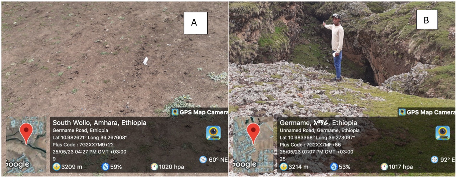
Figure 2. Clay soil (A), weathered Tarmaber-Megeze basalt (B).
3 Materials and methodology
3.1 Types and sources of data and software
Nine thematic criteria, built-up areas, slope, proximity to rivers, groundwater withdrawal points, land use and land cover, fault lines, roads, geology, and soil texture were analyzed to determine suitable landfill locations. The selection of the nine thematic criteria built-up areas, slope, proximity to rivers, groundwater withdrawal points, land use and land cover, fault lines, roads, geology, and soil texture was based on their environmental, socio-economic, and regulatory relevance in determining suitable landfill locations. These criteria were prioritized after an extensive review of solid waste management studies, national environmental policies, and consultations with experts in waste management, geospatial analysis, and environmental science. Built-up areas were considered to minimize public health risks and social conflicts, ensuring that the landfill is located at a safe distance from residential and commercial zones. Slope plays a crucial role in site stability, as steep slopes can increase erosion and leachate runoff, contaminating nearby water bodies. Proximity to rivers and groundwater withdrawal points was included to prevent water pollution, a key environmental concern in landfill site selection. Land use and land cover influence site accessibility and potential land-use conflicts, while fault lines were considered to avoid geologically unstable areas that could lead to structural failure of landfill liners. Road networks were included to ensure efficient waste transportation and minimize logistical costs. Geology and soil texture were prioritized because impermeable soil and suitable geological formations help reduce leachate infiltration and groundwater contamination. The selection of these criteria over others was guided by international landfill siting guidelines and Ethiopian environmental regulations, ensuring the model’s applicability to the study area.
To ensure a comprehensive and reliable site selection process, various geospatial datasets and remote sensing tools were utilized. The land use/land cover (LULC) and built-up maps were generated from a 2023 Landsat 8 OLI image with a 30 m resolution, obtained from the United States Geological Survey (USGS). To extract slope and river network parameters, a high-resolution 12.5 m digital elevation model (DEM) was acquired from the Alaska Satellite Facility. Additionally, geological and fault proximity maps were developed by digitizing the geological map of the Dessie area, sourced from the Geological Survey of Ethiopia (GSE). Soil texture classification was derived from FAO’s digital soil maps, while groundwater well locations were recorded using GPS during field surveys. The integration of these diverse datasets provided a robust analytical framework for evaluating site suitability. The datasets and their respective sources are given in Table 1.

Table 1. Data sources and formats.
The analysis was conducted using ArcGIS 10.7, ERDAS Imagine 2015, and the AHP model extension. ArcGIS was employed for digitization, spatial analysis, and thematic mapping, while ERDAS Imagine was used to classify Landsat 8 images into LULC categories and detect built-up areas. The AHP model extension in ArcGIS facilitated multi-criteria decision-making by calculating weight factors, consistency indices, and confusion matrices, ensuring the accuracy and reliability of the final suitability map. By integrating these datasets and analytical tools, the study effectively identified and ranked suitable sites for solid waste disposal in Gimba. The resulting classification map serves as a critical decision-support tool for urban planners and policymakers in optimizing waste management strategies.
3.2 Preparations of thematic layers
The process of creating thematic layers involves various steps such as digitizing maps, buffering, digital image processing of remote sensing data, and integrating field data to extract relevant information. In order to generate thematic maps for slope, soil texture, fault, road network, built-up areas, geology, land use and land cover (LULC), groundwater well points, and river network, remote sensing data (DEM and Landsat8 OLI) and field data were utilized within a GIS environment. To create a LULC map, a cloud-free Landsat 8 OLI-TIRS image with a combination of seven bands (band 1 to band 7) was employed. This image was subjected to supervised image classification using the maximum likelihood algorithm classifier. For the groundwater well points, location data collected from field surveys were used and then buffered. All the data layers were rectified to ensure they have the same size and projection system. To determine the proximity of certain features, such as roads, rivers, and built-up areas, buffering was performed at intervals of 500 meters. For fault proximity and groundwater well points proximity, buffering was done at intervals of 1,000 meters. These proximity layers were then classified into five subclasses based on previous studies. Finally, the road, fault, river, built-up, groundwater well points, geology, and soil texture thematic layers were rasterized using ArcGIS.
3.3 Weighting and ranking of thematic parameters
Weighting each thematic parameter is necessary because not all thematic layers have the same impact on waste disposal site selection. To determine the weights of the parameters and identify the most suitable landfill site, the GIS-based AHP technique was employed. The process involved ranking the classes in each layer, assigning weights to the thematic layers, calculating the factor weight for the nine thematic layers, and testing the consistency ratio using the Saaty AHP concept (Saaty, 2008). A pair-wise comparison square matrix was created to compare all nine thematic layers (slope, soil texture, fault, road network, built-up, geology, LULC, GW well point, and river network) against each other using Saaty’s 1–9 scale (Table 2). The IDRIS Selva AHP extension package was utilized to calculate the weight for each parameter and the consistency ratio of the 9 by 9 pair-wise comparison matrices, following a specific set of steps (Lee et al., 2001).
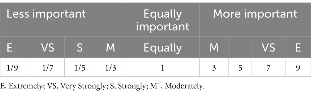
Table 2. Saaty’s Scale for assignment and its interpretation shows the pair-wise comparison process (Saaty, 2008).
Step 1: Creating a hierarchical structure.
Step 2: Create a pair-wise comparison grid—based on the relative importance of the goal considering n criteria to be compared (in this case nine thematic layers: slope, soil texture, fault, road network, built-up, geology, LULC, GW well point, and river network), such a 9 by 9 square matrix A = (aij) where i and j symbolize the row and the column, respectively, are produced. After creating the matrix, A = aij, the matrix below the main diagonal was filled by taking the reciprocal values of the matrix of the main diagonal using the formula aij = 1/aji as shown in Equation 1:
Step 3: add all the elements of column j of the matrix A using Equation 2 gives:
Step 4: Divide all the elements of the column by the sum of the column to get the normalized pairwise matrix Equation 3 (divide a matrix aij = pi/Pj Equation 1 by Equation 2):
The Criteria weight of a row ‘i’ (wi) is calculated as the average of elements Equation 3 of the row ‘i’ or the sum of elements of row ‘i’ of the normalized pairwise matrix to the number of parameters (thematic layers) Equation 4:
Step 5: Determine the consistency: The consistency ratio (CR) evaluates the consistency of the pair-wise comparison grid. According to Saaty (2008), matrices with a CR value greater than 0.1 are rejected, and the process should be repeated until the weight assignment is accurate and the CR value is less than 0.1. The CR is calculated using Equation 5:
Here, CR represents the consistency ratio, CI represents the consistency index, and RI represents the random index. The consistency index (CI) can be computed using Equation 6:
Where, λmax denotes the largest Eigenvalue of the pair-wise comparison matrix. To calculate λmax, multiply the normalized value from Equation 3 by the respective weight from Equation 4, and then sum up the products. The value of n represents the number of parameters, as shown in Equation 7:
Additionally, RI refers to the random index (Saaty’s ratio index). Table 3 provides the RI values for different n values. In this study, which includes nine parameters, the random index (RI) value is 1.45.
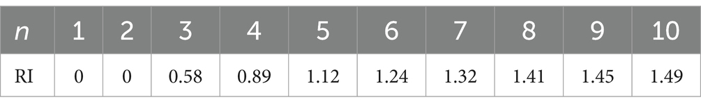
Table 3. Saaty’s ratio index (RI) for different values of n (Saaty, 2008).
3.4 Overlay analysis
Overlay analysis involves the integration of IDRS Selva software, AHP extension package and ArcGIS 10.7 weighted overlay algorithm. This analysis incorporates dispensing rates for different classes in a layer and weights for nine thematic layers. By utilizing Equation 8 in a spatial analysis tool, the final Solid Waste Disposal site (SWDS) map was generated. The SWDS index, derived from the AHP model, represents a range of index values that are subsequently classified into four suitability classes: unsuitable, less suitable, suitable, and highly suitable.
Where SWDS = solid waste disposal sites, Wi = weight for each parameter, and Ri = rates for the classes within the thematic layer generated from AHP. General workflow of the study illustrating the sequential steps followed for solid waste disposal site selection. The process begins with data collection and preparation of thematic layers, followed by the application of the Analytic Hierarchy Process (AHP) to assign weights to each criterion. Weighted overlay analysis is then conducted in the Geographic Information System (GIS) environment to generate a suitability map, culminating in the identification of optimal landfill sites for Gimba Town (Figure 3).
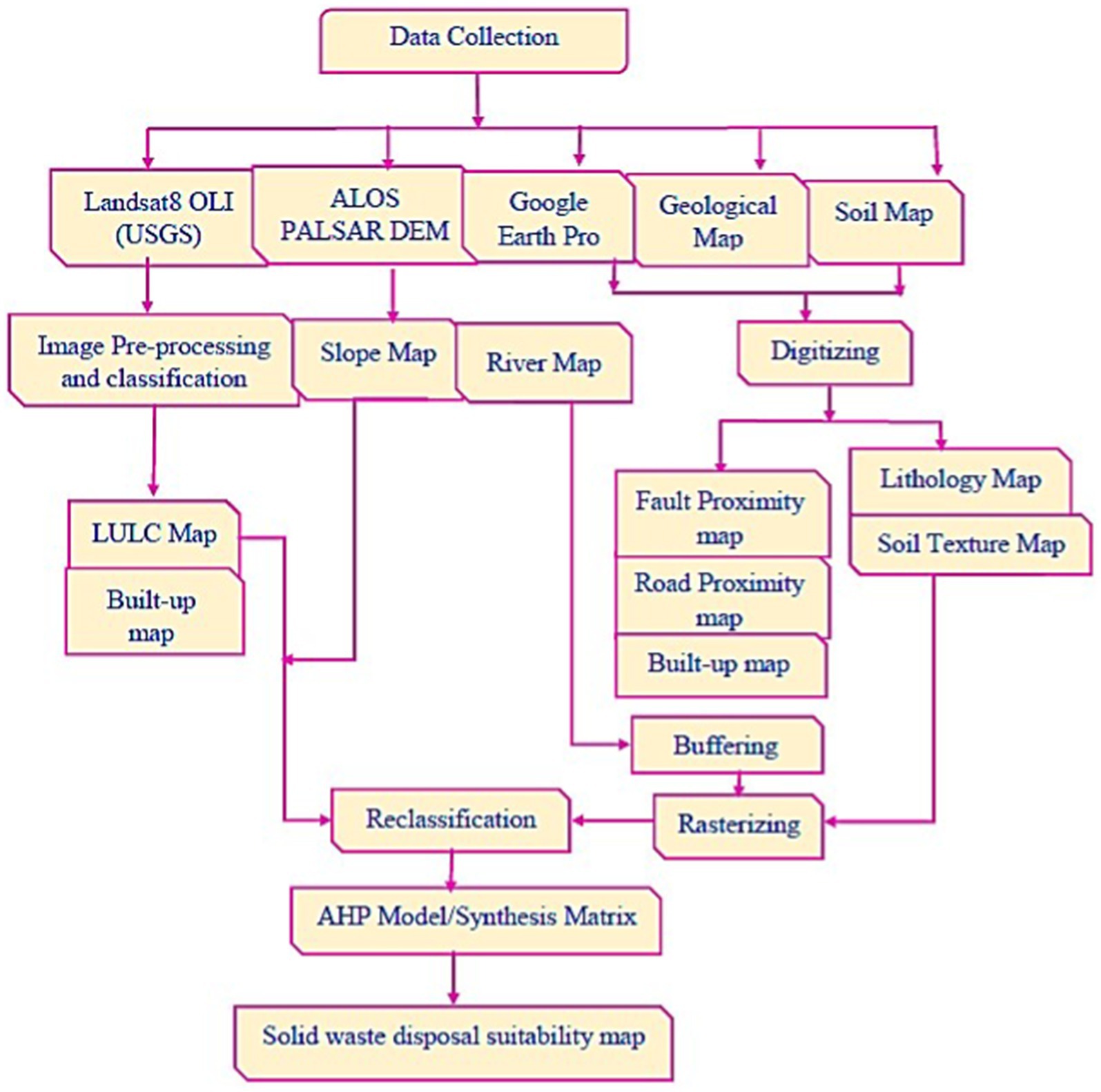
Figure 3. General work flow for the study.
4 Results and discussions
4.1 Thematic layers
4.1.1 Slope
Slope is a critical factor in landfill site selection, as it directly influences construction feasibility, operational stability, and environmental impact. The results of this study indicate that only 12.6% (20.8 km2) of the study area falls within the highly suitable category (5–10% slope), while 9.7% (15.9 km2) is classified as suitable (0–5% slope). In contrast, a significant portion of the study area—29.2% (48.0 km2) and 28.7% (47.3 km2)—was identified as unsuitable and less suitable, respectively, due to steep slopes or excessively flat terrain (Table 4, Figure 4A). The findings align with established standards, where slopes between 5 and 15% are generally recommended for landfill construction (Casini et al., 2015; Eskandari et al., 2016). This range ensures that the site is neither too steep—leading to structural instability and increased leachate flow risks—nor too flat, which could result in poor drainage and water accumulation. However, certain studies propose a narrower range of 8 to 12% as optimal for both construction ease and effective drainage management (Mihiretie, 2020). The observed distribution in Gimba town suggests that terrain constraints significantly limit landfill suitability, reinforcing the importance of integrating topographical assessments in site selection.
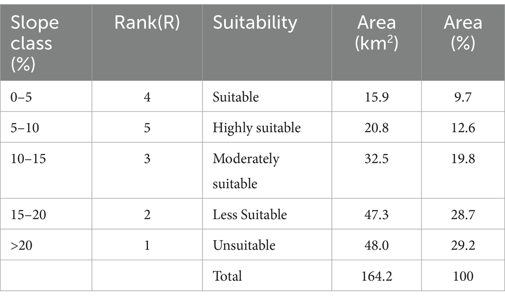
Table 4. Classification, rank, and area of slope factor.
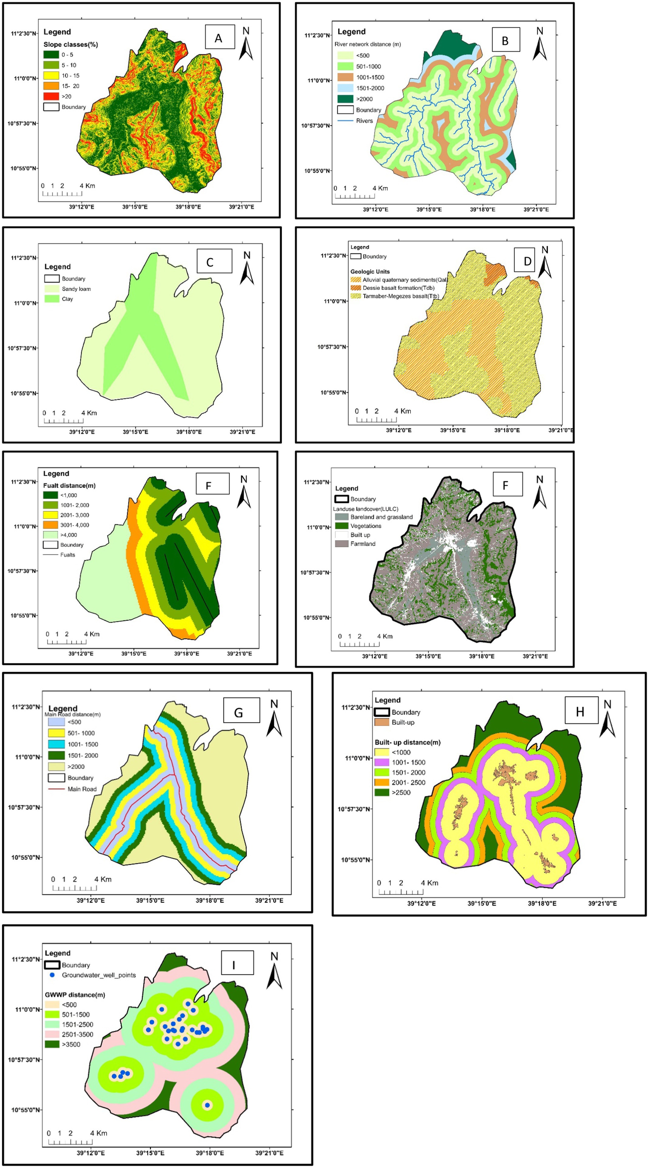
Figure 4. Maps for: Slope class (A), proximity to river (B), soil texture (C), geologic unit (D), proximity to fault (E), LULC (F), proximity to road (G), proximity to built-up (H), Proximity to GWW well points (I).
The suitability classifications derived from the ALOS PALSAR digital elevation model (12.5 m resolution) and ranked using the Kontos et al. (2005) methodology align with findings from Leao et al. (2004), Şener et al. (2011a), Safavian et al. (2015), Asefa et al. (2021), Jothimani et al. (2021), Wang et al. (2022), and Majid and Mir (2021). These studies emphasize the critical role of slope in landfill stability, particularly in regions with rugged terrain where construction feasibility becomes a concern. The high percentage of unsuitable and less suitable areas in Gimba town suggests that alternative engineering interventions, such as slope stabilization measures or landfill site modifications, may be necessary to accommodate waste disposal demands. The predominance of unsuitable and less suitable land underscores the need for multi-criteria decision-making approaches that go beyond slope considerations. While slope is a key determinant, landfill siting should integrate hydrological, geological, and socio-environmental factors to ensure sustainability. Given that nearly 58% of the study area is classified as less suitable or unsuitable, it is crucial to explore alternative solutions such as engineered landfill designs, slope modification techniques, and decentralized waste management strategies to enhance landfill viability. In conclusion, the findings highlight the topographical limitations of Gimba town in accommodating landfill sites. Future studies should consider advanced terrain modeling and hydrological risk assessments to refine site selection further, ensuring that waste disposal practices minimize environmental risks while optimizing land use efficiency.
4.1.2 Proximity to rivers
The results indicate that a significant portion of the study area is unsuitable for solid waste disposal due to its proximity to surface water bodies. Specifically, 76.3 km2 (46.4%) of the area falls within the highly unsuitable category (<500 meters from rivers), while 50.5 km2 (30.7%) is classified as less suitable (501–1,000 meters). This aligns with international guidelines, which emphasize the need for buffer zones to prevent leachate contamination and protect water quality (Kontos et al., 2005; Fenta, 2017). The Amhara National Regional State, through its Regional Hygiene and Environmental Executive Committee, mandates strict regulations (No.16/2000) prohibiting waste dumping in rivers, streams, and lakes. Furthermore, Ethiopian guidelines [Ethiopian Minister of Urban Development and Construction (EMUDC), 2012] recommend maintaining at least a 1,000-meter distance from streams to minimize water pollution risks. However, the findings suggest that only 7.6 km2 (4.2%) of the study area qualifies as either suitable or highly suitable for landfill siting, raising concerns about the availability of appropriate locations for waste disposal (Table 5, Figure 4B). The results reinforce previous research findings that inadequate buffer zones between landfills and water bodies increase contamination risks (Kontos et al., 2005; Fenta, 2017). While some international standards suggest a minimum 500-meter buffer, the Ethiopian Ministry of Urban Development and Construction [Ethiopian Minister of Urban Development and Construction (EMUDC), 2012] proposes a 1,000-meter buffer for safer waste disposal. Given that 77.1% of the study area falls within these restricted zones, the feasibility of landfill site selection in Gimba town is significantly constrained. These findings suggest that the selection of solid waste disposal sites in the region requires careful consideration of alternative waste management strategies. The high percentage of unsuitable areas highlights the need for engineered landfills with advanced leachate treatment systems or decentralized waste processing solutions to mitigate environmental risks. Overall, the findings highlight the severe spatial limitations for landfill site selection in Gimba town due to water proximity constraints. Future research should explore multi-criteria approaches integrating hydrological, geological, and socio-economic factors to develop a comprehensive waste management strategy that ensures environmental and public health safety.
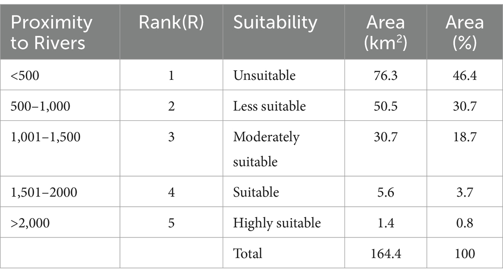
Table 5. Classification, rank, and area of proximity to river factor.
4.1.3 Soil texture
The findings indicate that soil texture plays a crucial role in determining the suitability of landfill sites. In the study area, two primary soil types clay and sandy loam were identified (Figure 4C). The analysis reveals that clay-rich soils, which account for 48.4 km2 (29.5%) of the area, are highly suitable for landfill siting, whereas sandy loam, covering 116 km2 (70.5%), is deemed unsuitable due to its high permeability (Table 6). These results are consistent with previous studies highlighting that low-permeability soils, particularly those with high clay content, are more effective in preventing leachate infiltration and groundwater contamination (Şener et al., 2011b; Yesilnacar and Cetin, 2008). Clay soil’s high retention capacity and low hydraulic conductivity reduce the risk of pollutant migration, making it the preferred choice for landfill construction (Eskandari et al., 2016; Rahmat et al., 2017). Conversely, sandy loam’s high infiltration rate poses a significant environmental hazard, as it facilitates the rapid movement of leachate into the groundwater system, potentially contaminating drinking water sources (Bagchi and Mitra, 2017; Magoura et al., 2023). Furthermore, given that only 29.5% of the study area is geologically suitable for landfilling, future site selection efforts should integrate hydrogeological assessments, soil stability analysis, and long-term environmental impact studies to ensure sustainable waste disposal practices. Land use planning policies should also restrict landfill development in high-permeability zones to protect groundwater resources (Rahmat et al., 2017; Magoura et al., 2023). Overall, the findings underscore the critical role of soil texture in landfill site selection and the urgent need for adaptive waste management strategies in regions dominated by permeable soils. Future research should focus on integrating geotechnical and hydrological criteria with socio-economic considerations to develop a comprehensive, risk-based landfill siting framework.
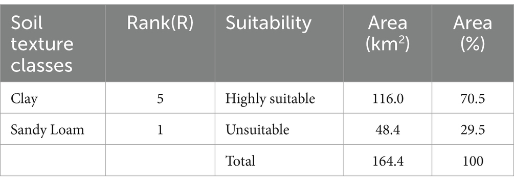
Table 6. Classification, rank, and area of soil texture factor.
4.1.4 Geology
The geological characteristics of the study area play a crucial role in determining the appropriateness of landfill sites, particularly in relation to permeability and structural stability. The analysis identifies three major geological units: alluvial sediments (Qal), Dessie Formation (Tdb), and Tarmaber-Megezez Formation (Ttb) (Figure 4D). Each unit exhibits distinct hydrogeological properties that impact landfill suitability. The alluvial sediments, covering 61.6 km2 (37.5%) of the study area, are highly permeable and geologically weak due to their lack of consolidation (Woldegebriel, 2019). This makes them unsuitable for landfill siting, as high permeability facilitates the rapid leaching of contaminants into groundwater (Ayenew, 2007). Previous studies have also highlighted the vulnerability of unconsolidated sediments to groundwater contamination, emphasizing the need to avoid waste disposal in such areas (Javaheri et al., 2007; Yesilnacar and Cetin, 2008). Conversely, the Dessie Formation, which comprises fine to medium-grained basalts and spans 3.9 km2 (2.4%), is classified as highly suitable for landfill development. The low permeability and compact nature of basaltic formations significantly reduce the risk of leachate infiltration, a key factor in ensuring long-term environmental safety (Eskandari et al., 2016). Similarly, the Tarmaber-Megezez Formation, composed of coarse-grained basalts, dominates 98.9 km2 (60.1%) of the study area and is deemed suitable for landfill siting (Kabite et al., 2012; Balcha et al., 2022). The compactness and durability of basaltic formations have been widely recognized as ideal geological conditions for landfill construction due to their low hydraulic conductivity and high structural integrity (Rahmat et al., 2017; Magoura et al., 2023). Moreover, land-use policies should prohibit landfill development in alluvial sediment zones to safeguard groundwater quality. Future waste management strategies should integrate geological and hydrogeological assessments with socio-economic and environmental considerations to ensure sustainable and scientifically sound landfill site selection (Table 7).
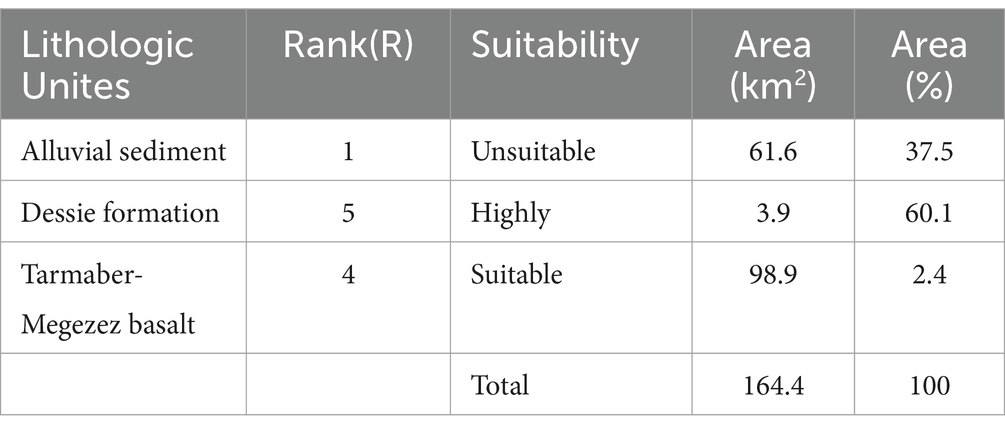
Table 7. Classification, rank, and area of geology factor.
4.1.5 Proximity to faults
The analysis of fault proximity in the study area revealed significant implications for landfill siting, particularly in regions characterized by tectonic activity. The findings indicate that approximately 43.5 km2 (26.5%) of the area, located within 1,000 meters of fault lines, is unsuitable for landfill development due to the high permeability of soils in fault zones. This elevated permeability increases the risk of groundwater contamination, as faults often act as conduits for leachate migration from waste disposal sites. As a result, placing landfills too close to fault lines can lead to the pollution of underground water sources, posing a serious environmental threat (Rafiee et al., 2011). Moderately suitable areas, covering 24 km2 (14.6%) of the study region, were identified where fault-induced permeability is somewhat lower. However, even in these areas, the risk of leachate migration remains a concern, requiring the implementation of precautionary measures such as containment systems to mitigate potential contamination. In contrast, sites located further from fault lines, covering 14.5 km2 (8.8%) for suitable areas and 42.8 km2 (26%) for highly suitable areas, were found to be at a much lower risk. These areas exhibit minimal permeability and are less likely to experience structural failure or groundwater pollution, even during seismic events.
The spatial distribution of fault proximity and suitability zones highlights the importance of strategic planning in landfill site selection. The results suggest that approximately 57.3 km2 (34.8%) of the study area is considered safe for landfill siting, emphasizing the need for informed decision-making that takes into account the geological characteristics of the region. This finding is consistent with previous studies, which have shown that fault zones, due to their fractured and faulted nature, present higher hydraulic conductivity, making them unsuitable for waste disposal without significant engineering interventions (Yesilnacar and Cetin, 2008). Moreover, landfills located in tectonically active areas are more vulnerable to structural failure, particularly in the event of seismic activity, which can compromise waste containment systems and exacerbate environmental risks (Ebrahimi et al., 2016). These results underscore the critical need for a combination of geological risk assessments and appropriate engineering measures when selecting landfill sites in tectonically active regions. The findings also highlight the necessity for policies and regulations that prioritize the avoidance of fault-prone areas for landfill siting. Such an approach would not only reduce the potential for groundwater contamination but also safeguard infrastructure and ensure the long-term sustainability of waste management practices in the region (Table 8).
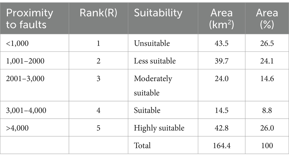
Table 8. Classification, rank, and area of proximity to fault factor.
4.1.6 Land use land cover (LULC)
The analysis of Land Use and Land Cover (LULC) in the study area, based on Landsat 8 OLI satellite imagery and supervised classification, revealed a diverse landscape that influences the suitability for solid waste disposal. The study classified the LULC into four main categories: built-up areas, farmlands, vegetation (including bushes, shrubs, and trees), and bare land and grasslands. These categories were determined using inputs from field surveys, previous studies, and the overall suitability of the area for solid waste disposal. The classification results were visualized in a map (Figure 4F), which provided a clear spatial representation of land cover types across the region. The findings suggest that bare land and grasslands, which constitute 25.2 km2 (15.4%) of the study area, are highly suitable for solid waste disposal. These areas are largely unutilized, with minimal environmental value in comparison to agricultural or built-up lands, making them ideal candidates for waste disposal, as they are less likely to cause contamination or negative impacts on surrounding ecosystems. This result is consistent with previous studies, such as those by Ethiopian Minister of Urban Development and Construction (EMUDC) (2012) and Balasooriya et al. (2015), which identified bare lands and grasslands as optimal sites for waste disposal due to their lower ecological sensitivity and reduced risk of pollution.
In contrast, built-up areas and farmlands were found to be unsuitable or less suitable for solid waste disposal. Built-up areas, which include infrastructure such as houses and roads, are inherently unsuitable due to the risks of waste affecting social health, contaminating nearby environments, and disrupting urban functionality. Farmlands, covering a significant portion of the study area, were classified as less suitable due to the potential negative effects of waste on agricultural productivity, such as soil contamination and reduced economic value. The proximity of waste to farmlands could also lead to public health issues, including the contamination of water supplies and soil. The land cover classification also revealed that built-up and farmland areas contribute approximately 7.55% to the overall suitability criteria for Solid Waste Disposal Site (SWDS) mapping. This proportion highlights the relatively low suitability of these land use types for waste disposal, reinforcing the importance of considering land use patterns when selecting appropriate sites for landfill or waste management facilities. Overall, the study’s LULC classification provides valuable insights into the spatial distribution of suitable and unsuitable areas for solid waste disposal. By identifying bare land and grasslands as highly suitable and built-up areas and farmlands as unsuitable or less suitable, the findings emphasize the need for strategic planning in waste disposal site selection, taking into account both environmental and socio-economic factors to minimize negative impacts (Table 9).
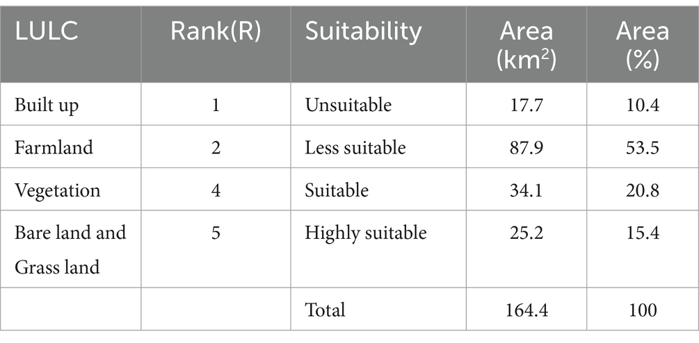
Table 9. Classification, rank, and area of LULC factor.
4.1.7 Proximity to road
The analysis of road proximity in the study area, based on a road map created using Google Earth Pro and topographic data, revealed key findings regarding the suitability of locations for solid waste disposal. The study defined a buffer zone at 500-meter intervals from the road (Figure 4G) to evaluate the impact of road accessibility on site selection. As indicated by previous research (Nas et al., 2010), waste disposal sites should be sufficiently accessible for transportation while being far enough from main roads to avoid exacerbating public health concerns associated with urban waste. The recommended distance for locating solid waste disposal sites from major roads ranges between 1,000 and 2,000 meters, as suggested by Ethiopian Minister of Urban Development and Construction (EMUDC) (2012). The results from the study confirm this guideline, with approximately 45.7 km2 (27.8%) of the area identified as suitable or highly suitable for solid waste disposal, falling within the optimal distance range of 1,000–2,000 meters from main roads.
Conversely, areas within 500 meters of the road were classified as unsuitable for solid waste disposal due to the increased risk of environmental and public health issues. Waste disposal sites located too close to urban roads can lead to negative impacts, such as the spread of contaminants through dust, improper waste management affecting nearby residential areas, and the overall degradation of the environment. This issue aligns with findings from various studies that highlight the importance of maintaining adequate distance from main roads to avoid exacerbating risks associated with waste accumulation near populated areas. Overall, the proximity to road networks contributes approximately 5.29% to the overall suitability weight for the Solid Waste Disposal Site (SWDS) mapping study. This analysis emphasizes the delicate balance between accessibility for waste transport and the need to minimize adverse environmental and public health impacts, particularly in urbanized regions. The findings reinforce the importance of careful planning and consideration of road networks when selecting sites for waste disposal, ensuring that these sites are both accessible for operational needs and adequately distanced from sensitive areas to mitigate risks (Table 10).
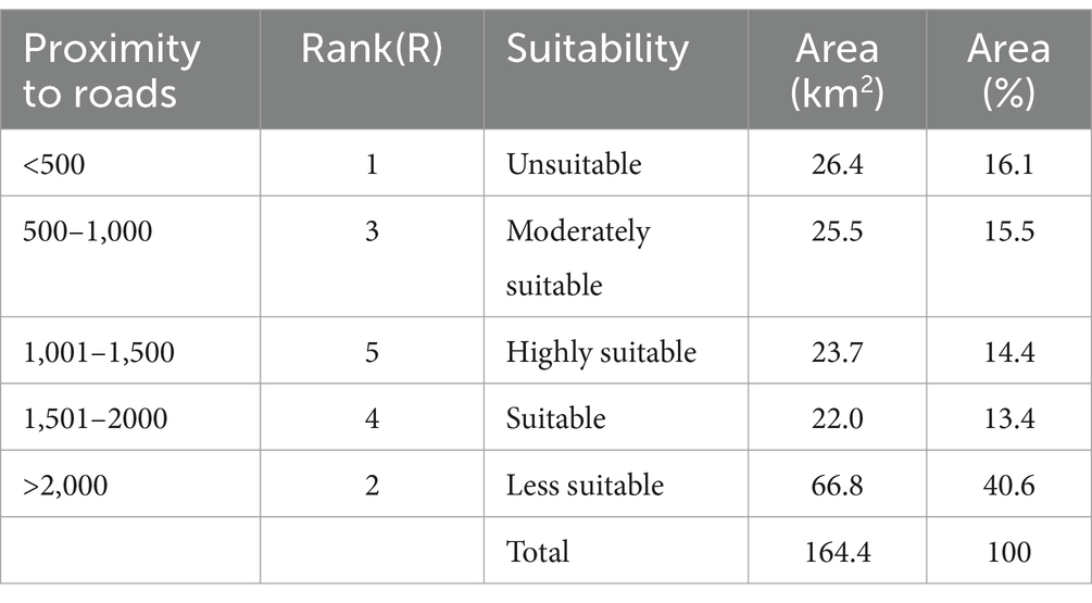
Table 10. Classification, rank, and area of proximity to road factor.
4.1.8 Proximity to built-up
The proximity of solid waste disposal sites to settlement areas, which include residential, commercial, and institutional zones, is a critical factor in determining the suitability of a site for waste management. In densely populated urban areas, the location of waste disposal facilities is particularly important due to the potential health, environmental, and socio-economic impacts on nearby residents. This study found that the disposal of solid waste near settlement areas poses significant challenges, especially concerning public health risks, nuisance from odors and noise, and the disruption of property values. According to the Environmental Protection Authority (EPA) (2007), it is recommended that solid waste disposal sites be located at least 500 meters away from any urban residential or commercial area. However, additional studies, including those by Ethiopian Minister of Urban Development and Construction (EMUDC) (2012), Ersoy and Bulut (2009), and Hasan et al. (2009), suggest that a more cautious approach would involve placing waste disposal sites at least 1 kilometer away from built-up areas to minimize adverse effects on public health and quality of life. These guidelines were incorporated into the current study, which used ArcGIS software to create buffer zones with 500-meter intervals around built-up areas, resulting in five proximity classes (Figure 4H).
The analysis revealed that areas within 1,000 meters of settlement zones are unsuitable for solid waste disposal. The proximity to urban centers increases the risk of a variety of issues, including contamination of the environment, the spread of disease, and public dissatisfaction due to noise and odor. Furthermore, solid waste disposal sites in close proximity to settlements may lead to a decline in property values, the presence of scavenging animals, and increased human-wildlife conflicts, all of which further highlight the unsuitability of these areas for waste management. The study calculated the influence of proximity to built-up areas as 30.68%, emphasizing the importance of this criterion in the overall suitability assessment for solid waste disposal site selection. As such, the findings underscore the need for careful consideration of settlement proximity when planning waste disposal facilities. To adhere to established guidelines and minimize the negative impacts on urban populations, it is essential to identify waste disposal sites located at a sufficient distance from built-up areas, thereby ensuring both public health and environmental protection (Table 11).
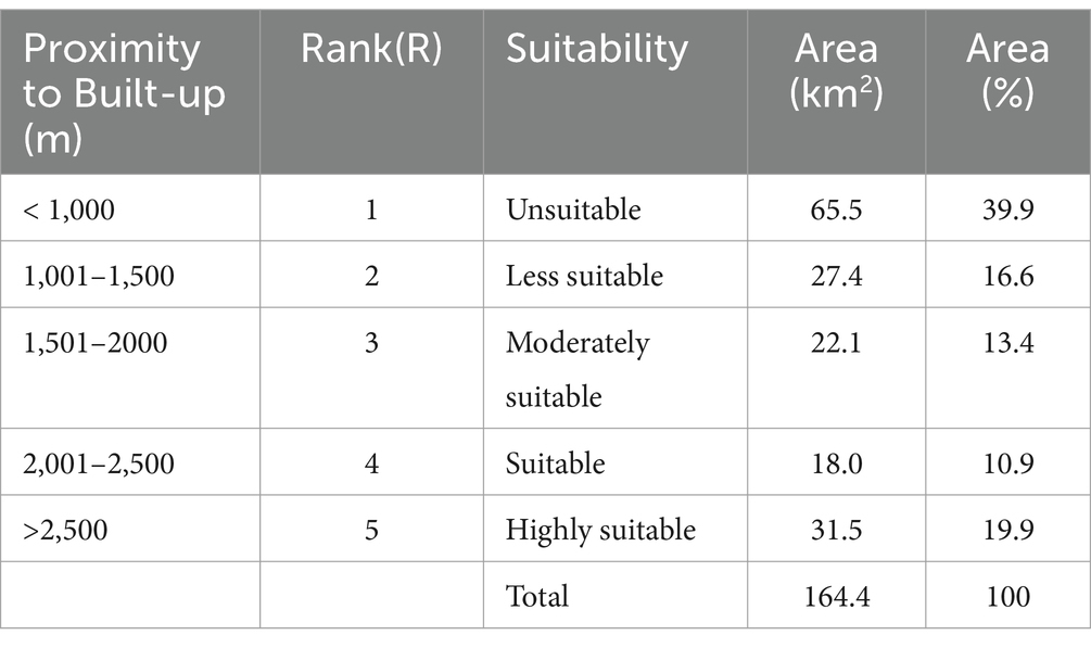
Table 11. Classification, rank, and area of built-up factor.
4.1.9 Proximity to groundwater well points
The proximity of solid waste disposal sites to groundwater wells is a critical factor in ensuring the protection of groundwater resources. Inappropriate waste disposal can lead to contamination of groundwater aquifers, which is a significant environmental and public health concern. To mitigate this risk, it is essential to identify and select disposal sites that are located at a sufficient distance from groundwater wells. In this study, a total of 31 functional groundwater borehole locations were identified during the field survey. These locations were then buffered using proximity tools in ArcGIS software, with intervals set at 1000 meters, creating five distinct proximity categories (Figure 4I). Based on recommendations from Ouma et al. (2011), it is advised that waste disposal sites should be located at least 500 meters away from groundwater wells to minimize the risk of contamination.
The analysis revealed that areas within 500 meters of groundwater wells were classified as unsuitable for waste disposal. This zone, covering approximately 16.2 km2 (9.8%) of the study area, represents a high-risk zone where the potential for leachate migration and groundwater contamination is significant. Furthermore, areas located between 501 and 1,500 meters were deemed less suitable for waste disposal, encompassing an additional 44.3 km2 (26.9%) of the study area. While these areas carry a lower risk than those within 500 meters, they still present potential environmental hazards and should be avoided for waste disposal purposes. Conversely, approximately 53.3 km2 (32.4%) of the study area falls within the suitable and highly suitable zones for waste disposal, as these locations are situated at a safer distance from groundwater wells. These areas pose a lower risk of groundwater contamination, making them more suitable for solid waste disposal, provided that additional containment and monitoring measures are in place. In conclusion, the findings highlight the critical importance of ensuring that solid waste disposal sites are located a sufficient distance away from groundwater wells to safeguard water quality and public health. Areas within 500 meters and 501–1,500 meters of groundwater wells are unsuitable or less suitable for waste disposal due to the high risk of contamination, while sites located further from groundwater sources offer safer alternatives for waste management. This assessment emphasizes the need for careful site selection and adherence to recommended proximity standards to protect vital water resources (Figures 4A-I, 5A,B; Table 12).
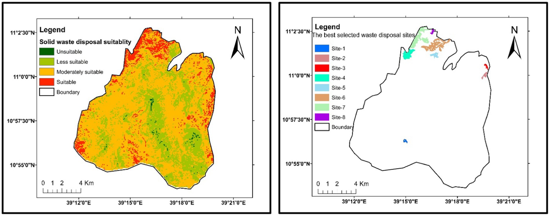
Figure 5. Solid waste disposal suitability map (A), suitability rank map (B).
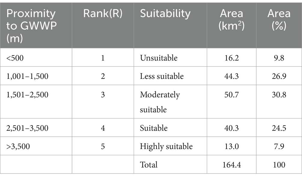
Table 12. Classification, rank, and area of GWWPs factor.
4.2 AHP model analysis and suitability mapping
To systematically rank the importance of these criteria, the Analytical Hierarchy Process (AHP) was employed. This decision-making tool allows for the quantification of subjective judgments, balancing expert opinions with scientific literature to derive an objective weight distribution. Experts in waste management, environmental science, urban planning, and hydrology participated in constructing the pairwise comparison matrix, where each criterion was compared against the others based on its relative importance in landfill site selection. The eigenvector method was used to calculate final weights, ensuring a structured and mathematically consistent weighting process. To validate the assigned weights and minimize potential biases, a Consistency Ratio (CR) was computed. A CR value below 0.1 confirmed that the pairwise comparisons were logically consistent, reinforcing the reliability of the expert assessments. This step was essential in ensuring that the weighting process was not overly influenced by subjective judgments but instead reflected scientific consensus and practical landfill siting considerations.
The suitability of areas for solid waste disposal sites was determined by considering nine factors: built-up, slope, river, GWWPs, LULC, fault, road, geology, and soil texture. Each thematic layer map was created using ArcGIS 10.7 spatial analyst tools. These layers were classified, reclassified, and rasterized. The weight of each factor was determined through pairwise comparisons using AHP techniques to assess their relative importance in determining suitability. The AHP model extension in ArcGIS software was utilized to calculate criteria weight (W) and check consistency ratio (CR) for decision-making. The resulting CR for the pairwise matrix was 0.041, which is below the threshold of 0.1. The factor weights (W) for the nine thematic layers were automatically calculated as follows: 30.33% for built-up, 21.95% for slope, 15.01% for river, 11.04% for GWWPs, 7.48% for LULC, 5.44% for fault, 3.89% for road, 2.79% for geology, and 2.09% for soil textures (Table 13). The factor weight directly corresponds to the influence of a factor on the selection of solid waste disposal sites in the model. A higher factor weight indicates a greater influence.

Table 13. Pairwise matric, weight and consistency ratio.
Furthermore, the influence and contribution of each subclass within a thematic layer were used to assign ranks (R) to them in relation to solid waste disposal sites. Subsequently, by selecting the “create map” option the solid waste disposal suitability map was automatically generated. To prepare the solid waste disposal sites, the factor weight (W) was multiplied by the rank (R) of each subclass in the thematic layer map using Equation 9, which was executed in the software behind the model. The equation used for calculating the solid waste disposal suitability (SWDS) is as follows (Kontos et al., 2005; Kabite et al., 2012; Jothimani et al., 2021; Magoura et al., 2023).
To generate the final landfill suitability map, a weighted overlay analysis was conducted in ArcGIS, integrating the nine thematic layers. Each layer was first standardized and reclassified into suitability classes, ensuring comparability. The final weights were then applied, and the layers were combined using a weighted linear combination (WLC) approach. Preprocessing steps, including spatial resampling and coordinate system standardization, were performed to maintain dataset consistency. The final landfill suitability map categorized areas into highly suitable, moderately suitable, and unsuitable zones, aligning with Ethiopian landfill site selection policies and international best practices. The accuracy of the model was verified through field assessments and comparative analysis with existing landfill sites, confirming the practical applicability of the proposed method. This map was then classified into four suitability classes: unsuitable, less suitable, moderately suitable, and suitable (Figure 5A). By analyzing the area of each suitability class in the ArcGIS environment, it was determined that 2.65 km (1.61%) and 56.91 km2 (43.62%) of the study area are unsuitable and less suitable for solid waste disposal sites. These areas are socially unfavorable, environmentally unfriendly, and economically important. They are also in close proximity to surface water, groundwater wells, built-up areas, faults, and roads, and have steep slope degrees (>200). Restricting the use of these areas is crucial in order to minimize negative impacts on the environment and public health. On the other hand, 78.38 km2 (47.69%) of the study area was found to be moderately suitable for solid waste disposal sites. Additionally, approximately 28.46 km2 (16.10%) of the study area is suitable for solid waste disposal sites. These areas have minimal effects on the environment and public health and are cost-effective, making them the most preferable locations for solid waste disposal sites.
The suitable areas for solid waste disposal sites are primarily located in the northern, eastern, and southern parts of Gimba town (Figure 5A). However, the suitable areas in the eastern and southern parts of the study area are situated in higher maintenance or elevated areas that serve as hydrogeologically recharge areas. Therefore, these areas are not recommended for dumping solid waste. On the other hand, the suitability areas in the northern part of the study area are the most favorable sites for solid waste disposal. These areas have the most suitable slope angles (50–100) and are located at optimal distances from roads, built-up areas, rivers, groundwater wells, and faults (Figure 5).
4.3 Landfill sites selected for waste disposal
The present study systematically reevaluates the areas identified as suitable for solid waste disposal, focusing on selecting the most optimal locations based on infrastructure proximity, hydrological and hydrogeological conditions, and socioeconomic factors. A key determinant of a sustainable waste disposal system is the size of the designated area. Generally, larger sites preferably those that can be utilized for a minimum of 10 years are favored due to their long-term sustainability and cost-effectiveness. Larger waste disposal sites reduce the need for repeated site selection, design, and construction, thereby minimizing operational expenses. In the case of Gimba and its surroundings, areas with a minimum coverage of 10 hectares were classified as most suitable, as determined through ArcGIS spatial analysis. Beyond size considerations, the final selection of suitable sites were refined based on multiple competing factors, including proximity to built-up areas, groundwater well protection zones (GWWPs), rivers, and roads. The proximity of waste disposal sites to urban settlements is a critical factor, as improper siting near residential areas poses serious public health risks and increases the likelihood of groundwater and surface water contamination particularly when located close to GWWPs and rivers. Such contamination threatens community well-being and ecological integrity. Additionally, proximity to main roads was a key consideration, as efficient transportation infrastructure is essential for waste collection and disposal logistics.
The suitability classification, as detailed in Table 14, highlights how certain areas were deemed less suitable despite meeting multiple criteria. This discrepancy arises due to factors such as competing land uses, slope limitations, and environmental constraints. For instance, while some locations may have favorable proximity to roads and urban areas, their high slope percentages (>15%) increase the risk of erosion and leachate runoff, reducing their overall suitability for waste containment. Furthermore, some regions may be designated for agricultural or residential purposes, limiting their viability for landfill development despite otherwise favorable conditions. Table 14 presents the ranked criteria, weighted based on their relative influence, with total percentages guiding the selection of the most suitable solid waste disposal sites. Based on these findings, the most appropriate sites for waste disposal are listed in order of suitability (Figures 5A,B).
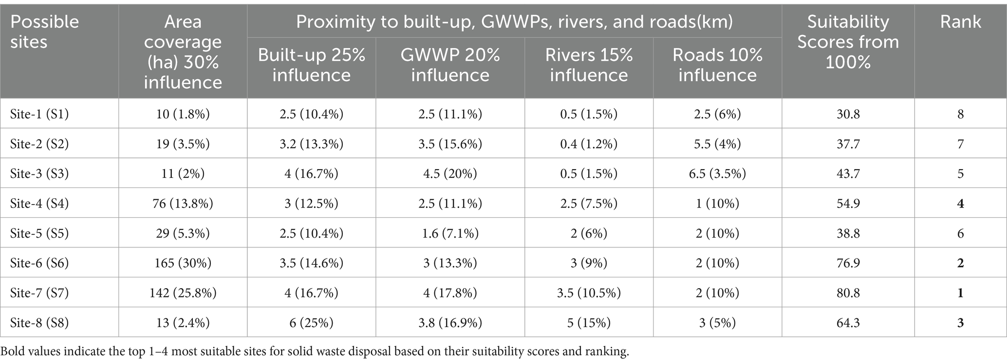
Table 14. The best suitable sites, suitability scores and ranks.
4.4 Validation of selected sites
To ensure the reliability and accuracy of the selected landfill sites, validation was conducted through a combination of ground verification and comparison with existing land use data. This validation process aimed to assess the consistency of the GIS-AHP model results with real-world conditions and existing spatial datasets. Field surveys were conducted to physically inspect the very highly suitable and highly suitable sites identified in the suitability map. These surveys focused on verifying land characteristics such as terrain, land use compatibility, proximity to water sources, and accessibility. Observations confirmed that the selected sites were free from major environmental and social constraints, such as high population density, agricultural activities, and protected areas. Photographic documentation and GPS coordinates were recorded to enhance the validation process.
The selected landfill sites were cross-checked against existing land use and land cover (LULC) datasets obtained from government agencies and previous studies. This comparison ensured that the proposed sites did not overlap with ecologically sensitive areas, residential zones, or culturally significant locations. The results indicated a strong correlation between the model outputs and existing land use classifications, reinforcing the reliability of the GIS-AHP approach in landfill site selection. To further validate the suitability of the identified sites, consultations were conducted with local urban planners, environmental experts, and municipal authorities. Their feedback was integrated to assess the socio-economic feasibility of the proposed landfill locations. The stakeholders acknowledged that the selected sites align with urban planning guidelines and do not pose significant conflicts with community interests. The validation process confirmed that the GIS-AHP model effectively identified landfill sites that meet both environmental and socio-economic criteria. The ground verification results and LULC comparison demonstrated a high degree of alignment with real-world conditions, while stakeholder feedback provided additional support for the model’s applicability in decision-making. These findings highlight the robustness of the methodology and underscore the importance of integrating field validation into GIS-based site selection studies.
5 Conclusion and recommendation
The improper handling of solid waste due to the absence of well-planned disposal sites, inadequate infrastructure, and limited awareness of appropriate site selection has resulted in severe environmental and public health challenges in Gimba town. These include the proliferation of vector-borne diseases, air pollution, and water contamination, with detrimental effects on both human well-being and ecological integrity. Effective solid waste management requires a strategic approach to site selection, integrating multiple environmental and socio-economic factors to ensure sustainability and minimal negative impacts. To address these challenges, this study employed an integrated Analytical Hierarchy Process (AHP) model with Geographic Information Systems (GIS) and remote sensing data to identify the most suitable waste disposal sites. The methodology incorporated nine thematic layers—soil texture, geology, land use and land cover, proximity to fault lines, built-up areas, roads, rivers, groundwater withdrawal points, and slopes—ensuring a comprehensive evaluation of potential sites. Each thematic factor was weighted according to its significance in waste disposal, and the AHP model’s consistency ratio (CR) was validated to ensure accuracy and reliability in the ranking process. The resulting suitability map classified locations into four categories: unsuitable, less suitable, moderately suitable, and suitable.
Through this analytical framework, eight optimal sites were identified based on their proximity to key environmental and infrastructural parameters. The highest-ranked site demonstrated an optimal balance between accessibility, environmental safety, and regulatory compliance. The accuracy of the AHP model was further validated through comparative analysis with existing waste disposal practices, highlighting its efficacy in mitigating environmental risks. The first-ranked site was selected based on its low risk of groundwater contamination, minimal proximity to densely populated areas, and accessibility for waste collection vehicles, demonstrating the model’s precision in aligning site selection with sustainability criteria. The findings underscore the urgent need for transitioning from open dumping practices to systematically planned waste disposal solutions. Given the increasing waste generation in urbanizing towns like Gimba, proactive measures must be taken to implement scientifically validated site selection strategies. The integration of GIS and AHP in solid waste management presents a scalable model for other urban centers facing similar challenges, providing a data-driven approach to enhancing environmental resilience and public health protection. Future studies should focus on incorporating real-time monitoring systems and public engagement strategies to further refine waste management practices and ensure community participation in sustainable urban planning. In addition future studies should incorporate stakeholder engagement by involving local authorities, environmental agencies, and communities in the decision-making process. This ensures transparency, addresses local concerns, and enhances site acceptance. A cost–benefit analysis should be conducted to evaluate financial feasibility, including construction, operation, and long-term maintenance costs. Assessing economic benefits, such as job creation and waste recycling potential, will strengthen policy decisions. Finally, long-term environmental and social impact assessments are essential to monitor groundwater quality, air pollution, and community health trends, ensuring sustainable waste management solutions.
Data availability statement
The original contributions presented in the study are included in the article/supplementary material, further inquiries can be directed to the corresponding author.
Ethics statement
Written informed consent was obtained from the individual(s) for the publication of any potentially identifiable images or data included in this article.
Author contributions
DT: Writing – original draft, Writing – review & editing. TS: Formal analysis, Methodology, Writing – review & editing. EA: Supervision, Writing – review & editing.
Funding
The author(s) declare that no financial support was received for the research and/or publication of this article.
Conflict of interest
The authors declare that the research was conducted in the absence of any commercial or financial relationships that could be construed as a potential conflict of interest.
Generative AI statement
The author(s) declare that no Generative AI was used in the creation of this manuscript.
Publisher’s note
All claims expressed in this article are solely those of the authors and do not necessarily represent those of their affiliated organizations, or those of the publisher, the editors and the reviewers. Any product that may be evaluated in this article, or claim that may be made by its manufacturer, is not guaranteed or endorsed by the publisher.
References
Akurugu, E., Issahaku, A. M., and Aliou, A. S. (2018). Application of factor analysis in the assessment of solid waste management in Bolgatanga municipality of Ghana. Sci. J. Appl. Math. Stat. 6:99. doi: 10.11648/j.sjams.20180603.15
Al-Jarrah, O., and Abu-Qdais, H. (2006). Municipal solid waste landfill siting using intelligent system. Waste Manag. 26, 299–306. doi: 10.1016/j.wasman.2005.01.026
Al-Khatib, I. A., Anayah, F. M., Al-Sari, M. I., Al-Madbouh, S., Salahat, J. I., and Jararaa, B. Y. (2023). Assessing physiochemical characteristics of agricultural waste and ready compost at Wadi Al‐Far’a Watershed of Palestine. J. Environ. Public Health. 2023:6147506.
Ampofo, S., Issifu, J. S., Kusibu, M. M., Mohammed, A. S., and Adiali, F. (2023). Selection of the final solid waste disposal site in the Bolgatanga municipality of Ghana using analytical hierarchy process (AHP) and multi-criteria evaluation (MCE). Heliyon 9:e18558. doi: 10.1016/j.heliyon.2023.e18558
Ampofo, S., Kumi, E., and Ampadu, B. (2015). Investigating solid waste management in the Bolgatanga municipality of the upper east region, Ghana. Environ. Pollut. 4, 20–25. doi: 10.5539/ep.v4n3p27
Ampofo, S., Sackeyb, I., Danaaa, L., and Kusibua, M. M. (2022). Multi-criteria assessment (Mca) and selection of a solid waste disposal site within Wa municipality, upper west region, Ghana. J. Wastes Biomass Manag. 4, 83–91. doi: 10.26480/jwbm.02.2022.83.91
Andrianov, A. A., Andrianova, O. N., Kuptsov, I. S., Svetlichny, L. I., and Utianskaya, T. V. (2019). Multi-criteria comparative evaluation of nuclear energy deployment scenarios with thermal and fast reactors. 방사성폐기물학회지 17, 47–58. doi: 10.7733/jnfcwt.2019.17.1.47
Aragonés-Beltrán, P., Pastor-Ferrando, J. P., García-García, F., and Pascual-Agulló, A. (2010). An analytic network process approach for siting a municipal solid waste plant in the metropolitan area of Valencia (Spain). J. Environ. Manag. 91, 1071–1086. doi: 10.1016/j.jenvman.2009.12.007
Asefa, B., and Mindahun, W. (2019). Suitable solid waste disposal site selection using geographical information system (GIS): a case of Debre Berhan town, Ethiopia. Am. J. Environ. Prot. 7, 17–23. doi: 10.12691/env-7-1-4
Asefa, E. M., Damtew, Y. T., and Barasa, K. B. (2021). Landfill site selection using GIS based multicriteria evaluation technique in Harar City, Eastern Ethiopia. Environ. Health Insights 15:11786302211053174. doi: 10.1177/11786302211053174
Assefa, M., and Girma, B. (2020). The impacts of poor solid waste management in legetafo-legedadi town, Oromia, Ethiopia. Urban and Regional Planning 5, 61–69.
Awino, F. B., and Apitz, S. E. (2024). Solid waste management in the context of the waste hierarchy and circular economy frameworks: An international critical review. Integr. Environ. Assess. Manag. 20, 9–35. doi: 10.1002/ieam.4774
Ayenew, T. (2007). Water management problems in the Ethiopian rift: Challenges for development. J. Afr. Earth Sci. 48, 222–236.
Bagchi, D., and Mitra, I. K. (2017). Life, labour, recycling: a study of waste management practices in contemporary Kolkata. Accumulation in Post-Colonial Capitalism 149–163.
Balasooriya, B. M. R. S., Vithanage, M., Nawarathna, N. J., Kawamoto, K., Zhang, M., Herath, G. B. B., et al. (2015). Municipal solid waste disposal site selection of Jigjiga town using GIS and remote sensing techniques, Ethiopia. Int. J. Sci. Res. Publ. 5:17.
Balcha, S. K., Awass, A. A., Hulluka, T. A., Ayele, G. T., and Bantider, A. (2022). Hydrological simulation in a rift-bounded lake system and implication of water abstraction: Central rift valley lakes Basin, Ethiopia. Water 14:3929.
Belay, L., Ayele, H. S., and Solomon, M. A. (2024). Analysis of some heavy metals and estimation of pollution indexes in open solid waste disposal site: The case of Bahir Dar City, Bahir Dar, Ethiopia. Ethiop. J. Sci. Technol. 17, 237–256.
Birkie, A., Addisu, S., and Mekuriaw, A. (2020). Solid waste management practice and dumpsite suitability analysis using GIS technology in Debre Markos town, Ethiopia. Ethiop. J. Sci. Technol. 13, 115–130. doi: 10.4314/ejst.v13i2.3
British Colombia Ministry of Environment (BCME) (2016). Landfill criteria for municipal solid waste. 2nd Edn. Victoria, BC, Canada, 76.
Casini, M., Mocenni, C., Paoletti, S., and Pranzo, M. (2015). Decision support system development for integrated management of European coastal lagoons. Environ. Model. Softw. 64, 47–57. doi: 10.1016/j.envsoft.2014.11.008
Chang, N. B., Parvathinathan, G., and Breeden, J. B. (2008). Combining GIS with fuzzy multicriteria decision-making for landfill siting in a fast-growing urban region. J. Environ. Manag. 87, 139–153. doi: 10.1016/j.jenvman.2007.01.011
Chaulya, S. K. (2003). Water resource development study for a mining region. Water Resour. Manag. 17, 297–316. doi: 10.1023/A:1024780602461
Chen, W. Y., and Kao, J. J. (2008). Air pollution directional risk assessment for siting a landfill. J. Air Waste Manage. Assoc. 58, 1539–1545. doi: 10.3155/1047-3289.58.12.1539
Coban, A., Ertis, I. F., and Cavdaroglu, N. A. (2018). Municipal solid waste management via multi-criteria decision making methods: a case study in Istanbul, Turkey. J. Clean. Prod. 180, 159–167. doi: 10.1016/j.jclepro.2018.01.130
Demesouka, O. E., Vavatsikos, A. P., and Anagnostopoulos, K. P. (2014). GIS-based multicriteria municipal solid waste landfill suitability analysis: a review of the methodologies performed and criteria implemented. Waste Manag. Res. 32, 270–296. doi: 10.1177/0734242X14526632
Ebistu, T. A., and Minale, A. S. (2013). Solid waste dumping site suitability analysis using geographic information system (GIS) and remote sensing for Bahir Dar town, North Western Ethiopia. Afr. J. Environ. Sci. Technol. 7, 976–989. doi: 10.5897/AJEST2013.1589
Ebrahimi, H., Ghazavi, R., and Karimi, H. (2016). Estimation of groundwater recharge from the rainfall and irrigation in an arid environment using inverse modeling approach and RS. Water Resour. Manag. 30, 1939–1951.
El Maguiri, A., Kissi, B., Idrissi, L., and Souabi, S. (2016). Landfill site selection using GIS, remote sensing and multicriteria decision analysis: case of the city of Mohammedia, Morocco. Bull. Eng. Geol. Environ. 75, 1301–1309. doi: 10.1007/s10064-016-0889-z
Environmental Protection Authority (EPA). (2007). Solid waste management proclamation no. 513/2007. Addis Ababa, Ethiopia.
Erasu, D., Feye, T., Kiros, A., and Balew, A. (2018). Municipal solid waste generation and disposal in robe town, Ethiopia. J. Air Waste Manage. Assoc. 68, 1391–1397. doi: 10.1080/10962247.2018.1467351
Ersoy, H., and Bulut, F. (2009). Spatial and multi-criteria decision analysis-based methodology for landfill site selection in growing urban regions. Waste Manag. Res. 27, 489–500. doi: 10.1177/0734242X08098430
Eskandari, M., Homaee, M., and Falamaki, A. (2016). Landfill site selection for municipal solid wastes in mountainous areas with landslide susceptibility. Environ. Sci. Pollut. Res. 23, 12423–12434. doi: 10.1007/s11356-016-6459-x
Ethiopian Minister of Urban Development and Construction (EMUDC). (2012). Solid waste management manual: With respect to urban plans, Sanitary Landfill Sites and Solid Waste Management Planning.
Fenta, B. A. (2017). Waste management in the case of Bahir Dar City near Lake Tana shore in northwestern Ethiopia: a review. Afr. J. Environ. Sci. Technol. 11, 393–412. doi: 10.5897/AJEST2017.2340
Geological Survey of Ethiopia (GSE). (2015). Geological map and reports of Ethiopia. Addis Ababa, Ethiopia.
Gimba Town Municipality. (2023). Solid waste management report of Gimba Town [Unpublished report]. Gimba Town Municipality.
Habtamu, A. (2001). GIS and remote sensing-based solid waste landfill site selection: Acase of Addis Ababa city. Waste Manag. Res. 19, 564–568.
Hailu, Y., Hanchiso, T., and Bereta, A. (2019). Municipal solid waste suitable disposal site selection, case study, Wolkite town, Ethiopia. Int. J. Environ. Sci. Nat. Resour. 20, 126–131. doi: 10.19080/IJESNR.2019.20.556044
Hasan, M. R., Tetsuo, K., and Islam, S. A. (2009). Landfill demand and allocation for municipal solid waste disposal in Dhaka city—an assessment in a GIS environment. J. Civil Eng. 37, 133–149.
Hashim, S. (2013). Urban solid waste management based on geoinformatics technology. Afr. J. Environ. Waste Manag. 1, 056–061.
Higgs, G. (2006). Integrating multi-criteria techniques with geographical information systems in waste facility location to enhance public participation. Waste Manag. Res. 24, 105–117. doi: 10.1177/0734242X06063817
Hoornweg, D., and Bhada-Tata, P. (2012). Urban development series knowledge papers. Washington, DC, USA: The World Bank Group; WBG, 1–98.
Javaheri, H., Nasrabadi, T., Jafarian, M. H., Rowshan, G. R., and Khoshnam, H. (2007). Site selection of municipal solid waste landfills using analytical hierarchy process method in a geographical information technology environment in Giroft.
Jerie, S., and Zulu, S. (2017). Site suitability analysis for solid waste landfill site location using geographic information systems and remote sensing: a case study of Banket town board, Zimbabwe. Rev. Soc. Sci. 2, 19–31. doi: 10.18533/rss.v2i4.99
Jha, A. K., Singh, S. K., Singh, G. P., and Gupta, P. K. (2011). Sustainable municipal solid waste management in low income group of cities: a review. Trop. Ecol. 52, 123–131.
Jothimani, M., Geberslasie, A., and Duraisamy, R. (2021) “Suitable sites identification for solid waste disposal using geographic information system and analytical hierarchy process method in debark town, northwestern Ethiopia.” In IOP Conference Series: Earth and Environmental science (Vol. 795, 012016 IOP Publishing.
Jovanovic, S., Savic, S., Jovicic, N., Boskovic, G., and Djordjevic, Z. (2016). Using multi-criteria decision making for selection of the optimal strategy for municipal solid waste management. Waste Manag. Res. 34, 884–895. doi: 10.1177/0734242X16654753
Kabite, G., Suryabhagavan, K. V., Argaw, M., and Sulaiman, H. (2012). GIS-based solid waste landfill site selection in Addis Ababa, Ethiopia. Int. J. Ecol. Environ. Sci. 38, 59–72.
Karsauliya, S. (2013). Application of remote sensing and GIS in solid waste management: a case study of surroundings of river Yamuna, India. Int. J. Environ. Eng. Manag. 4, 2231–1319.
Kaza, L. C., Yao, P. B.-T., and Van Woerden, F. (2018). What a waste 2.0; what a waste 2.0: A global snapshot of solid waste management to 2050: A global snapshot of solid waste management to 2050, urban development, ©. Washington, DC: World Bank.
Kebede, H. A., and Ayenew, W. A. (2023). Solid waste disposal site selection analysis using geospatial technology in Dessie city Ethiopia. Heliyon 9. doi: 10.1016/j.heliyon.2023.e18865
Khan, D., and Samadder, S. R. (2014). Municipal solid waste management using geographical information system aided methods: a mini review. Waste Manag. Res. 32, 1049–1062. doi: 10.1177/0734242X14554644
Khan, I., Chowdhury, S., and Techato, K. (2022). Waste to energy in developing countries—a rapid review: opportunities, challenges, and policies in selected countries of sub-saharan Africa and south asia towards sustainability. Sustain. For. 14:3740. doi: 10.3390/su14073740
Kocak, E., and Baglitas, H. H. (2022). The path to sustainable municipal solid waste management: do human development, energy efficiency, and income inequality matter? Sustain. Dev. 30, 1947–1962. doi: 10.1002/sd.2361
Kontos, T. D., Komilis, D. P., and Halvadakis, C. P. (2005). Siting MSW landfills with a spatial multiple criteria analysis methodology. Waste Manag. 25, 818–832. doi: 10.1016/j.wasman.2005.04.002
Leao, S., Bishop, I., and Evans, D. (2004). Spatial–temporal model for demand and allocation of waste landfills in growing urban regions. Comput. Environ. Urban. Syst. 28, 353–385. doi: 10.1016/S0198-9715(03)00043-7
Lee, W. B., Lau, H., Liu, Z. Z., and Tam, S. (2001). A fuzzy analytic hierarchy process approach in modular product design. Expert. Syst. 18, 32–42. doi: 10.1111/1468-0394.00153
Maalouf, A., and Mavropoulos, A. (2023). Re-assessing global municipal solid waste generation. Waste Manag. Res. 41, 936–947. doi: 10.1177/0734242X221074116
Maalouf, A., Mavropoulos, A., and El-Fadel, M. (2020). Global municipal solid waste infrastructure: delivery and forecast of uncontrolled disposal. Waste Manag. Res. 38, 1028–1036. doi: 10.1177/0734242X20935170
Magoura, A., Dehimi, S., and Redjem, A. (2023). A GIS-based multi-criteria evaluation of landfill site selection in the region of Hodna, Algeria. J. Degraded Mining Lands Manag. 10:4709. doi: 10.15243/jdmlm.2023.104.4709
Majid, M., and Mir, B. A. (2021). Landfill site selection using GIS based multi criteria evaluation technique. a case study of Srinagar city, India. Environmental. Challenges 3:100031. doi: 10.1016/j.envc.2021.100031
Mihiretie, A. (2020). Suitable solid waste disposal site selection using geographical information system: a case of Debre Markos town, Ethiopia. Int. J. Environ. Geoinform. 9, 1–8. doi: 10.30897/ijegeo.784087
Minnesota Pollution Control Agency (MPCA). (2005). Demolition landfill guidance (pp. 1–13): Water/Solid Waste #5.04.
Mmereki, D., Baldwin, A., and Li, B. (2016). A comparative analysis of solid waste management in developed, developing and lesser developed countries. Environ. Technol. Rev. 5, 120–141. doi: 10.1080/21622515.2016.1259357
Mor, S., Ravindra, K., De Visscher, A., Dahiya, R. P., and Chandra, A. (2006). Municipal solid waste characterization and its assessment for potential methane generation: a case study. Sci. Total Environ. 371, 1–10. doi: 10.1016/j.scitotenv.2006.04.014
Mortazavi Chamchali, M., Mohebbi Tafreshi, A., and Mohebbi Tafreshi, G. (2021). Utilizing GIS linked to AHP for landfill site selection in Rudbar County of Iran. GeoJournal 86, 163–183.
Mussa, A., and Suryabhagavan, K. V. (2021). Solid waste dumping site selection using GIS-based multi-criteria spatial modeling: a case study in logia town, Afar region, Ethiopia. Geol. Ecol. Landscapes 5, 186–198. doi: 10.1080/24749508.2019.1703311
Nas, B., Cay, T., Iscan, F., and Berktay, A. (2010). Selection of MSW landfill site for Konya, Turkey using GIS and multi-criteria evaluation. Environ. Monit. Assess. 160, 491–500. doi: 10.1007/s10661-008-0713-8
Ouma, Y. O., Kipkorir, E. C., and Tateishi, R. (2011). MCDA-GIS integrated approach for optimized landfill site selection for growing urban regions: an application of neighborhood-proximity analysis. Ann. GIS. 17, 43–62.
Penido, J. H., Mansur, G. L., and Segala, K. (2009). Manual on municipal solid waste integrated Management in Latin American and Caribbean Cities: International development and research Centre.
Pheakdey, D. V., Quan, N. V., Khanh, T. D., and Xuan, T. D. (2022). Challenges and priorities of municipal solid waste management in Cambodia. Int. J. Environ. Res. Public Health 19:8458. doi: 10.3390/ijerph19148458
Rafiee, R., Khorasani, N., Mahiny, A. S., Darvishsefat, A. A., Danekar, A., and Hasan, S. E. (2011). Siting transfer stations for municipal solid waste using a spatial multi-criteria analysis. Environ. Eng. Geosci. 17, 143–154. doi: 10.2113/gseegeosci.17.2.143
Rahman, M. M., Sultana, K. R., and Hoque, M. A. (2008). Suitable sites for urban solid waste disposal using GIS approach in Khulna city, Bangladesh. Proc. Pakistan Acad. Sci. 45, 11–22.
Rahmat, Z. G., Niri, M. V., Alavi, N., Goudarzi, G., Babaei, A. A., Baboli, Z., et al. (2017). Landfill site selection using GIS and AHP: a case study: Behbahan, Iran. KSCE J. Civ. Eng. 21, 111–118.
Ravichandran, C., and Venkatesan, G. (2021). “Toward sustainable solid waste management -challenges and opportunities,” in Handbook of advanced approaches towards pollution prevention and control. eds. R. O. Abdel Rahman and C. M. Hussain (Elsevier), 67–103.
Saaty, T. L. (2008). Decision making with the analytic hierarchy process. Int. J. Serv. Sci. 1, 83–98. doi: 10.1504/IJSSCI.2008.017590
Saeed, M. O., Hassan, M. N., and Mujeebu, M. A. (2008). “Development of municipal solid waste generation and recyclable components rate of Kuala Lumpur: Perspective study,” in International Conference on Environment (ICENV 2008) Penang, Malaysia. p. 15–17.
Safavian, S. T. S., Fataei, E., Ebadi, T., and Mohamadian, A. (2015). Site selection of Sarein's municipal solid waste landfill using the GIS technique and SAW method. Int. J. Environ. Sci. Dev. 6, 934–937. doi: 10.7763/IJESD.2015.V6.725
Sasikumar, G., Sivasangari, A., and Venkatachalam, N. (2022). Application of analytical hierarchy process (AHP) for assessment of collection and transportation of solid waste: an empirical study. Nat. Environ. Pollut. Technol. 21, 283–288. doi: 10.46488/NEPT.2022.v21i01.033
Semaw, F. (2018). The problem of solid waste site selection in Woldia town. J. Remote Sens. GIS 7:2. doi: 10.4172/2469-4134.1000246
Şener, Ş., Şener, E., and Bilgehan, N. A. S. (2011a). Selection of landfill site using GIS and multicriteria decision analysis for Beyşehir Lake catchment area (Konya, Turkey). Mühendislik Bilimleri ve Tasarım Dergisi 1, 134–144.
Şener, Ş., Sener, E., and Karagüzel, R. (2011b). Solid waste disposal site selection with GIS and AHP methodology: a case study in Senirkent -Uluborlu (Isparta) Basin, Turkey. Environ. Monit. Assess. 173, 533–554.
Shah, S. A., Musavi, S. H. A., Tameez, A., Alam, M., and Nawaz, A. (2018). Analyzing site suitability for solid waste disposal through GIS multi-criteria decision making hierarchy process. 3c. Tecnología 7, 65–80. doi: 10.17993/3ctecno.2019.specialissue.07
Sharma, K. D., and Jain, S. (2020). Municipal solid waste generation, composition, and management: the global scenario. Soc. Responsib. J. 16, 917–948. doi: 10.1108/SRJ-06-2019-0210
Sisay, T. (2024). Application of optical images and analytical hierarchy process model for solid waste dumping site analysis in Kombolcha town, Northeastern Ethiopia. Heliyon. 10. doi: 10.1016/j.heliyon.2024.e33474
Susunaga-Miranda, M. A., Ortiz-Muñiz, B., Estévez-Garrido, B. M., Susunaga-Estévez, R. M., Díaz-González, M., and Castellanos-Onorio, O. P. (2023). Greenhouse gas emissions from the abandoned solid waste final disposal site of the City of Veracruz, Mexico. Enfoque UTE 14, 1–8. doi: 10.29019/enfoqueute.988
Torabi-Kaveh, M., Babazadeh, R., Mohammadi, S. D., and Zaresefat, M. (2016). Landfill site selection using combination of GIS and fuzzy AHP, a case study: Iranshahr, Iran. Waste Manag. Res. 34, 438–448. doi: 10.1177/0734242X16633777
Torkayesh, A. E., Malmir, B., and Asadabadi, M. R. (2021). Sustainable waste disposal technology selection: the stratified best-worst multi-criteria decision-making method. Waste Manag. 122, 100–112. doi: 10.1016/j.wasman.2020.12.040
Troschinetz, A. M., and Mihelcic, J. R. (2009). Sustainable recycling of municipal solid waste in developing countries. Waste Manag. 29, 915–923. doi: 10.1016/j.wasman.2008.04.016
Vatalis, K., and Manoliadis, O. (2002). A two-level multicriteria DSS for landfill site selection using GIS: case study in Western Macedonia, Greece. J. Geogr. Inf. Decis. Anal. 6, 49–56.
Velis, C. A., Wilson, D. C., Gavish, Y., Grimes, S. M., and Whiteman, A. (2023). Socio-economic development drives solid waste management performance in cities: a global analysis using machine learning. Sci. Total Environ. 872:161913. doi: 10.1016/j.scitotenv.2023.161913
Vinti, G., Bauza, V., Clasen, T., Medlicott, K., Tudor, T., Zurbrugg, C., et al. (2021). Municipal solid waste management and adverse HealthOutcomes: a systematic review. Int. J. Environ. Res. Public Health 18:4331. doi: 10.3390/ijerph18084331
Volsuuri, E., Owusu-Sekyere, E., and Imoro, A. Z. (2022). Rethinking solid waste governance in Ghana. Heliyon 8:e12235. doi: 10.1016/j.heliyon.2022.e12235
Wang, S., Han, Z., Wang, J., He, X., Zhou, Z., and Hu, X. (2022). Environmental risk assessment and factors influencing heavy metal concentrations in the soil of municipal solid waste landfills. Waste Manag. 139, 330–340. doi: 10.1016/j.wasman.2021.11.036
Wang, Y., Li, J., An, D., Xi, B., Tang, J., Wang, Y., et al. (2018). Site selection for municipal solid waste landfill considering environmental health risks. Resour. Conserv. Recycl. 138, 40–46. doi: 10.1016/j.resconrec.2018.07.008
Weerakoon, K. G. P. K. (2002). “Integration of GIS based suitability analysis and multicriteria evaluation for urban land use planning; contribution from the analytic hierarchy process.” In 23rd Asian Conference on Remote Sensing, ACRS Urban Planning, Kathmandu, Nepal. pp. 25–29.
Woldegebriel, M. (2019). Assessment of extent and coverage of urban solid waste management service delivery in selected urban Kebeles of Wolaita Sodo town Ethiopia. London J. Res. Human. Soc. Sci.
Woldetsadik, A. A. (2017). Practices of solid waste management by municipality and community in Oromia regional state of Ethiopia: a case of Adama City, Ethiopia. SSRG Int. J. Agric. Environ. Sci. 4, 1–7. doi: 10.14445/23942568/IJAES-V4I1P101
World Bank Group. (2019). Urban and rural municipal solid waste in China and the circular Economy: A Brief Overview and Opportunities Going Forward.
World Bank Group (2022). What a waste 2.0: A global snapshot of solid waste management to 2050. Washington DC, USA: World Bank Publications.
Yesilnacar, M. I., and Cetin, H. (2008). An environmental geomorphologic approach to site selection for hazardous wastes. Environ. Geol. 55, 1659–1671.
Yildirim, V., Memisoglu, T., Bediroglu, S., and Colak, H. E. (2018). Municipal solid waste landfill site selection using multi-criteria decision making and GIS: case study of Bursa province. J. Environ. Eng. Landsc. Manag. 26, 107–119. doi: 10.3846/16486897.2017.1364646
Yoon, S., Choi, S., and Ko, W. (2017). An integrated multicriteria decision-making approach for evaluating nuclear fuel cycle systems for long-term sustainability on the basis of an equilibrium model: technique for order of preference by similarity to ideal solution, preference ranking organization method for enrichment evaluation, and multiattribute utility theory combined with analytic hierarchy process. Nucl. Eng. Technol. 49, 148–164. doi: 10.1016/j.net.2016.07.009
Keywords: Geographic Information System (GIS), Analytic Hierarchy Process (AHP), landfill site selection, solid waste management, suitability analysis, Multi-Criteria Decision Analysis (MCDA), environmental sustainability
Citation: Sisay T, Teku D and Abebaw E (2025) Solid waste disposal site selection using GIS and the Analytic Hierarchy Process model: a case study conducted in Gimba Town, Northeastern Ethiopia. Front. Sustain. 6:1528851. doi: 10.3389/frsus.2025.1528851
Edited by:
Christian Zurbrügg, Swiss Federal Institute of Aquatic Science and Technology, SwitzerlandReviewed by:
Ernieza Suhana Mokhtar, Centre of Studies for Surveying Science and Geomatics, Universi, MalaysiaSandra Cunha, University of Trás-os-Montes and Alto Douro, Portugal
Copyright © 2025 Sisay, Teku and Abebaw. This is an open-access article distributed under the terms of the Creative Commons Attribution License (CC BY). The use, distribution or reproduction in other forums is permitted, provided the original author(s) and the copyright owner(s) are credited and that the original publication in this journal is cited, in accordance with accepted academic practice. No use, distribution or reproduction is permitted which does not comply with these terms.
*Correspondence: Degfie Teku, ZGVnZmllMjAyM0BnbWFpbC5jb20=