 Qingquan Sun
 Lexuan Huang
 Han Meng1
 Liang Chi
 Jianzhai Wu
 Xiangyang Zhou
- 1Agricultural Information Institute, Chinese Academy of Agricultural Sciences, Beijing, China
- 2School of Geography and Information Engineering, China University of Geosciences, Wuhan, China
Introduction: Land use change simulation is crucial for understanding global environmental changes and guiding sustainable land management. This study conducts a bibliometric analysis of 2,147 Web of Science articles from 1988 to 2023 to summarize research trends, thematic evolutions, and future directions in land use change modeling.
Methods: Using Biblioshiny tools, the study applies quantitative analytics, co-citation network mapping, and keyword clustering.
Results: The research reveals three developmental phases. From 1988 to 2000 (62 articles), foundational models like CLUE and CA were developed. During 2001–2016 (1,039 articles), there were advancements in coupled models and multi-scenario simulations. From 2017 to 2023 (1,046 articles), the focus shifted to integrative frameworks linking land dynamics, ecosystem services, and climate feedbacks. Annual publication outputs increased from 5 to 149, showing exponential growth. Key research themes involve computational modeling, spatiotemporal dynamics analysis, and environmental impact assessment. Recent trends highlight “river-basin,” “multi-source data fusion,” and “geographically weighted models,” indicating a move toward basin-scale simulations, machine learning integration, and policy-oriented scenarios. China, the U.S., and Germany lead in research output, with top institutions including Beijing Normal University and the Chinese Academy of Sciences. China and the U.S. have strong domestic collaborations, while European countries have higher international collaboration ratios.
Discussion: The analysis points out research gaps, such as limited integration of socio-economic drivers and insufficient cross-scale modeling. Future research should focus on developing hybrid frameworks combining process-based and data-driven models, leveraging multi-source data for accuracy, and designing scenario-based models for sustainable development goals, especially in river basins and urbanizing regions.
1 Introduction
Land resources are undoubtedly the cornerstone for the establishment and evolution of human societies (Long, 2022). The global land area is around 14.9 billion hectares. Nevertheless, currently, a significant quarter of this vast expanse is mired in the process of degradation. The report “The State of the World’s Land and Water Resources for Food and Agriculture: Systems at breaking point” by the Food and Agriculture Organization of the United Nations emphasizes that the degradation of terrestrial soil and land has reached a critical stage. This degradation is endangering the future food supply for nearly 10 billion people by 2050 (Elizabeth, 2022). Confronted with this formidable challenge, the United Nations has strongly urged all countries to actively carry out their solemn obligations to restore 1 billion hectares of land. Meanwhile, to ensure the smooth realization of the United Nations Sustainable Development Goal SDG15 by 2030, the International Resource Panel has identified land restoration as a crucial remedial measure. Against this crucial backdrop, simulating and predicting future land-use scenarios is of great significance for addressing the problems faced by global land resources and achieving sustainable development goals.
Land use is a globally significant issue that has attracted extensive attention and committed efforts from the academic community. A large number of scholarly articles have been published on this topic. Just the papers with “land use” in their titles amount to a remarkable 36,000, and around 28% of them focus on simulating and predicting land use change. After a thorough review of existing studies, we find that the dominant methods for simulating or forecasting land use change mainly rely on Geographic Information Systems (GIS), Remote Sensing (RS) technologies, or statistical models (Jafari et al., 2016; Aburas et al., 2019). To improve the effectiveness of simulation predictions, researchers often explore advanced techniques. These include, but are not limited to, model optimization and integration, deep learning algorithms, multiscale analytical frameworks, multiscenario simulation methods, and multi-source data fusion strategies. These technological approaches complement each other and work together to enhance the accuracy and reliability of research findings.
Currently, models developed for simulating or predicting land use change are mostly extensions and optimizations based on the Cellular Automaton (CA), Conversion of Land Use and its Effects (CLUE) models, Agent-Based Model (ABM), and deep-learning-based methods such as the Long Short-Term Memory (LSTM) network (Zheng and Hu, 2018). The CA model is a rule-based discrete model. It defines the rules and transition probabilities of interactions among cells (terrestrial units) to simulate the non-linear and self-organizing behavior of land use change. This characteristic makes it suitable for complex system modeling. By adjusting various initial conditions and parametric settings, which involve different policy, economic, social, and environmental variables (Xu et al., 2021), the CA model can analyze specific scenarios and predict the future evolution of land use patterns. The CA-Markov model, derived from the combination of the CA and Markov models, breaks down the land use change process into a cell-level decision-making process. It also incorporates spatial correlations and time-series features. As a result, this model can effectively address the limitations of the single CA model in aspects such as temporal dynamics, spatial correlations, multi-source data fusion, utilization of historical information, and prediction accuracy (Guan et al., 2019).
The CLUE model is based on a spatially explicit approach. It is used to simulate the spatial configurations and dynamic evolutions of land use change along different developmental paths. This model has wide applications in simulations across large spatial scales (Niu and Pan, 2021). Unlike the CA model, which mainly emphasizes local rules, the CLUE model focuses on the driving forces and conversion mechanisms of land use change. Widely adopted in various academic fields such as geography, ecology, and agronomy, the CLUE model serves as a fundamental framework for interdisciplinary integration and development. Its improved version, the CLUE-S model, is often used to predict the spatiotemporal dynamics of land use changes, landscape pattern alterations, and three-dimensional spatial changes. Moreover, the CLUE-S model can be coupled with models like InVEST and Markov. This coupling enables the validation and precise assessment of the accuracy and reliability of simulation results.
Agent-Based Modeling (ABM) is a computational model used to simulate the behaviors and interactions of autonomous agents (Lamperti et al., 2018; Bao and Fritchman, 2018). In the early days, ABMs were mostly applied at the local scale. However, they are now being extended toward the regional scale (Matthews et al., 2007; Crooks and Castle, 2011). For instance, a case study in the Netherlands proposed a conceptual framework of ABM. By integrating agent types, farm trajectories, and probabilistic decision-making processes, this framework analyzed regional land use and cover changes. Moreover, it was parameterized using empirical data, enhancing the model’s practicality in regional research (Valbuena et al., 2010). Additionally, ABMs are constantly being integrated with other technologies. Some studies have introduced deep learning into ABMs to improve model accuracy (Shiono, 2021).
Deep-learning-based models, such as LSTM (Hochreiter and Schmidhuber, 1997), have significant advantages in processing time-series data and capturing complex change patterns (Xu and Yang, 2025). They can learn hidden land use change patterns from large amounts of data. However, they require a large volume of data and have relatively poor interpretability. They are suitable for predicting long-term land use change trends and conducting high-precision simulations and predictions of land use change when sufficient data is available (Zhao et al., 2023).
In the simulation research of land-use change models, multi-scenario simulation serves as a crucial means to gain insights into future land-use dynamics (Sankarrao et al., 2021). From the perspective of policy orientation, policy-driven scenario simulation focuses on the implementation effects of different land policies. For example, during the urbanization process, changes in urban planning policies, such as new district development or old-city renovation plans, can alter the urban land-use pattern. Multi-scenario simulation can demonstrate the growth models of urban land and the changes in functional zoning under different planning policies (Li et al., 2024; Zhou et al., 2020; Domingo et al., 2021). Economic factors are also a core force shaping land-use changes. In a scenario of rapid economic growth and continuous industrial structure upgrading, industrial land may transform toward a more agglomerated and highly efficient utilization pattern due to the development of high-tech industries. Conversely, in a scenario of economic slowdown or difficult industrial transformation, traditional industrial land may face problems such as idleness or inefficient utilization. Simulation can clearly illustrate these change processes, providing a basis for the coordinated development of the economy and land use (Xu et al., 2025). Environment-driven scenario simulation, on the other hand, concentrates on the impacts of environmental factors such as ecological protection and climate change on land use. Against the backdrop of addressing climate change, factors like sea-level rise and an increase in extreme climate events can change the suitability of land. By simulating different climate change scenarios, it is possible to predict the risk of land inundation in coastal areas and the layout adjustments of agricultural land due to changes in climate conditions (Wu and Wang, 2025).
The relevant literature in the field of land use change simulation is extensive and complex. Relying solely on reading to comprehensively understand and analyze the research landscape in this area is a difficult task. In this context, bibliometrics becomes crucial and essential. Bibliometrics is of great importance for clarifying academic collaboration networks, evaluating the impact of articles, identifying research trends, selecting research methods and technological means, and exploring interdisciplinary research directions. It involves quantitatively analyzing and visualizing indexed literature through the use of mathematical, statistical, and bibliographic techniques. There are several notable tools for bibliometric analysis, such as Histcite, VOSviewer, SATI, Bibexcel, CiteSpace, and Bibliometrix. Each tool has its own unique principles and focuses. Histcite analyzes citation connections to mainly reveal the historical development and trends in a scientific field. However, it is limited by its restricted database support and relatively narrow functionality. VOSviewer uses clustering algorithms based on similarity matrices calculated from documents to classify similar literature and display the clustering results through visualization. Nevertheless, it currently only supports English-language literature, and some of its visualization results may not be very satisfactory (Li et al., 2021). SATI conducts quantitative and visual examinations of literature by extracting bibliographic details and applying methods like co-word analysis, multidimensional scaling, and clustering. However, it may face challenges in uncovering micro-concepts in the literature and differentiating between disciplinary sub-fields. Occasional inaccuracies in counting the frequencies of macro-keywords could potentially affect theoretical inferences (Bornmann and Marx, 2012). Bibexcel processes and analyzes literature data using text mining and data analytics methods. Unfortunately, it has a complex user interface and limited functionality (Bornmann and Marx, 2012). CiteSpace, based on the principle of co-occurrence clustering, extracts and reconstructs informational entities (such as keywords, authors, and institutions) from the literature corpus, creating diverse and meaningful network structures. It measures and visualizes these structures to reveal the knowledge framework and evolutionary patterns within a discipline. However, its performance may decrease when dealing with large-scale datasets (Bukar et al., 2023). Bibliometrix is an open-source tool developed in the R programming language. It not only enables comprehensive bibliometric analysis and various visualization techniques but also allows for customized development according to specific needs. It has been widely used in the academic community (Chen and Kong, 2023). Biblioshiny, developed by further using the Shiny package, integrates the core code of Bibliometrix into a web-based data analysis framework. This tool combines a graphical interface, bibliometric analysis, and visualization methods, smoothly incorporating the functions of Bibliometrix and offering researchers a relatively complete and intuitive analysis tool (Li et al., 2023).
The Web of Science (WOS) is committed to curating high-quality academic journals and conference papers. Currently, in the field of bibliometrics, the Web of Science Core Collection has accumulated a collection of 260,000 articles. However, the number of articles related to land use is relatively small, with just over 100. Among these land-use-related articles, 53% of the research is associated with climate change, its impacts, and management. Significantly, research specifically focused on land use change simulation and prediction is extremely scarce (Li and Song, 2023). To address this gap, this study utilizes the Biblioshiny tool to systematically analyze and statistically examine the literature on land use change simulation and prediction in the Web of Science Core Collection from 1988 to 2023. The main objectives of this research are as follows: (1) The kinetic evolution and trends permeating research within this field. (2) The identification, assessment, and analysis of the academic sway exerted by core authors, preeminent institutions, pivotal journals, and leading nations in this arena. (3) The exploration of extant research hotspots and the challenges therein. (4) The prognostication of prospective research trajectories in land use change simulation and prediction.
2 Data collection
The Web of Science (WOS), originally developed by Eugene Garfield, is now managed and advanced by Clarivate Analytics. It indexes high-quality and highly impactful journals distributed globally, starting from 1900. In this study, to obtain literature relevant to land use change simulation and prediction, a search formula based on article titles and abstracts was applied: TI = (Simulation of “Land Use Change*”) OR AB = (Simulation of “Land Use Change*”). The search was carried out on December 23, 2023. After filtering out articles that did not match the research focus through manual screening of titles and abstracts to extract relevant records, a total of 2,147 records were collected. These records were then archived as comprehensive records and cited references in the “BibTeX” format for further analysis.
In the bibliometric analysis of this study, to ensure the selection of literature highly relevant to land use change simulation, a manual screening method of carefully perusing titles and abstracts was adopted. Based on the Web of Science Core Collection, after retrieving 2,196 pieces of literature using a specific search formula, meticulous manual screening commenced. In the initial title-screening phase, non-English literature, conference abstracts, and studies clearly unrelated to the research were excluded. Subsequently, in the in-depth abstract-reading stage, relying on domain knowledge, literature involving simulation models (such as Cellular Automata, Conversion of Land Use and its Effects, etc.), methodologies (such as Markov chains, etc.), scenario predictions, or model validations were strictly selected. A total of 49 records were removed during this process. To guarantee the screening quality, 10% of the literature was randomly selected for double-blind cross-verification by two reviewers. The inter-rater agreement reached 92%. The final dataset was then processed by removing duplicates, standardizing keywords, and normalizing institutional names before being archived. Although manual screening is time-consuming, it can accurately identify emerging themes, providing reliable data for subsequent research. Moreover, the screening process and criteria will be presented in the form of a flowchart in the future, ensuring the traceability and reproducibility of the research.
3 Research methods
This study utilized the Biblioshiny tool to implement a three-part analytical framework for the literature on “land use change simulation.” The framework includes quantitative analysis, citation analysis, and content visualization analysis. The quantitative analysis focused on parameters such as the number of publications, types of publishing journals, keyword frequencies, research institutions, and countries. This analysis is essential for understanding the research activities in the field, evaluating the academic impact and dissemination range of research results, identifying current research hotspots and frontiers, and assessing the research capabilities of different institutions. The citation analysis comprehensively examined both locally and globally highly-cited papers. These pioneering research findings can serve as a valuable source of knowledge for future researchers in the area of land use change simulation and prediction. To visually depict the research evolution in this field, Sankey diagrams were strategically employed at three different time points. These diagrams are useful for identifying research hotspots and frontiers in different development stages of the field.
Biblioshiny is developed based on the bibliometrix package in the R programming language. It constructs an intuitive graphical operating environment for bibliometric analysis, and its technical principles cover multiple aspects such as data processing, analytical model construction, and visual presentation. In the data-processing stage, the software can parse literature data from multiple databases like Web of Science and Scopus, and it supports the import of formats such as BibTeX and RIS. Through text-mining techniques, it extracts key information from fields such as literature titles, abstracts, and keywords, and then conducts data cleaning and standardization. For example, it can remove duplicate words and correct formatting errors, laying a solid data foundation for subsequent analyses.
Entering the analysis stage, Biblioshiny employs a variety of mature algorithms to perform diverse bibliometric analyses. Taking co-occurrence analysis as an example, when constructing a co-occurrence matrix, the software traverses all the literature and counts the co-occurrence frequencies of word pairs (such as keyword pairs). Suppose the set of words is {A, B, C}. If A and B appear simultaneously in a literature, the values at the corresponding positions of (A, B) and (B, A) in the matrix are incremented by 1 (co-occurrence matrices are usually symmetric). For the analysis of author collaboration networks, based on the co-author relationships in the literature, graph-theoretic algorithms are used to construct a network model. Nodes represent authors, edges denote co-author relationships, and the weight of an edge can be set as the number of co-authoring times, thereby intuitively presenting the collaboration patterns among researchers. When calculating literature impact indicators (such as the h-index), the established formula is followed: the maximum value of h such that a given author or journal has published at least h papers, and each of these papers has been cited at least h times. Through statistical operations on data such as the citation frequencies of literature, the academic influence of the literature or the author is evaluated.
In terms of visualization, Biblioshiny utilizes layout algorithms (such as the Force-Atlas 2 algorithm) to transform analysis results into intuitive graphs. Taking the visualization of keyword co-occurrence networks as an example, this algorithm mimics the action of physical forces to arrange nodes (keywords) and edges (co-occurrence relationships) reasonably on a two-dimensional plane. The size of a node can reflect the frequency of a keyword’s appearance or its centrality, and the thickness of an edge represents the strength of the co-occurrence, enabling researchers to gain insights into the knowledge associations underlying the literature data.
4 Results
4.1 Analysis of the number of publications and issuing journals
4.1.1 Annual trend of publications
The articles pertinent to land use change simulation and prediction traverse the temporal span from 1988 to 2023. The aggregate trend manifested in the publication count evinces a growth trajectory. Based on the publication volume, the research chronicle can be demarcated into three sequential epochs: the nascent stage spanning from 1988 to 2000 (encompassing 62 articles), the phase of rapid expansion from 2001 to 2016 (comprising 1,039 articles), and the active phase from 2017 to 2023 (incorporating 1,046 articles) (Figure 1).
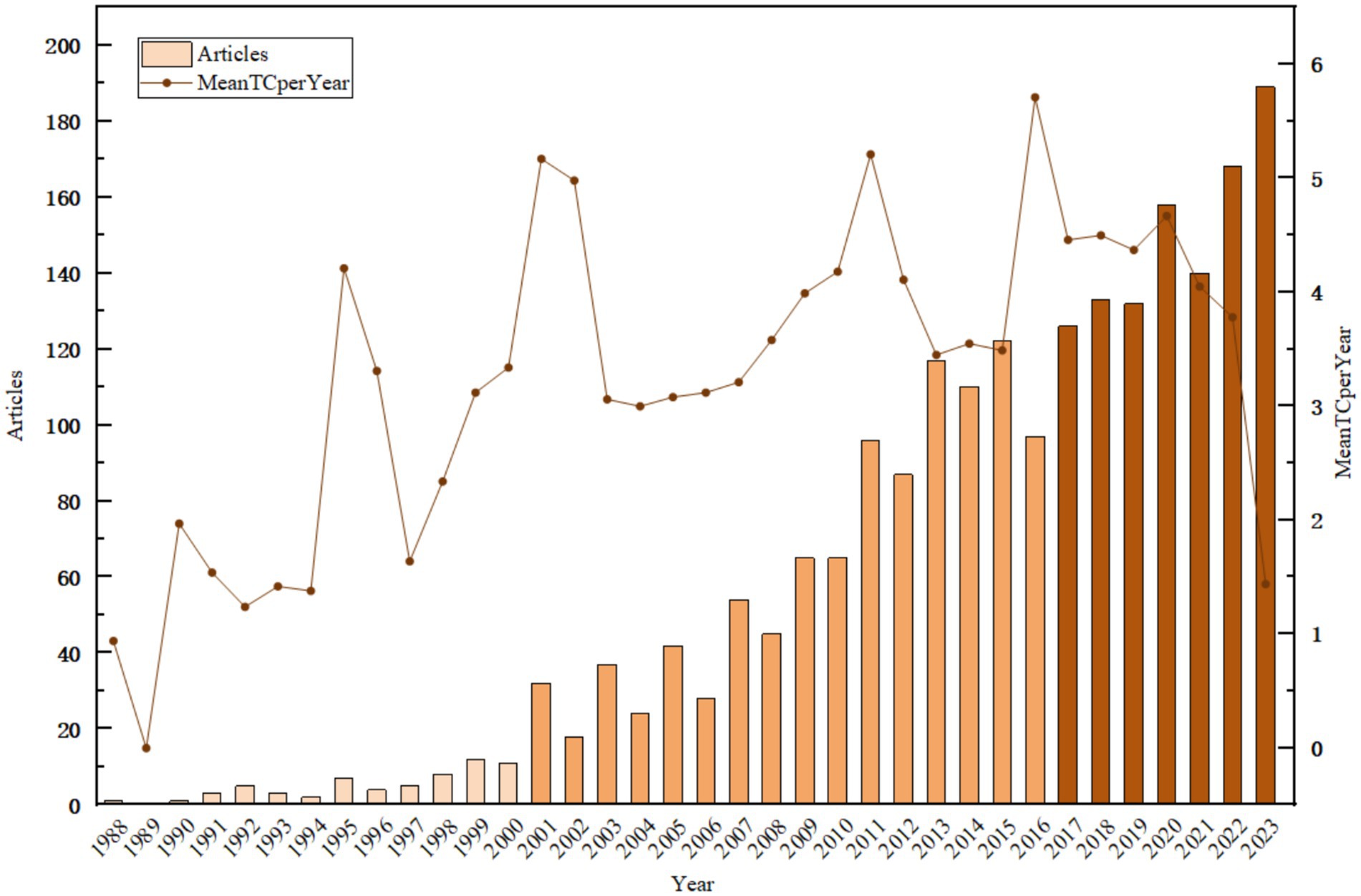
Figure 1. Number of publications and annual mean total citations in the field of land use change simulation and prediction from 1988 to 2023.
During the nascent stage, the publication tally constituted less than 3% of the aggregate. Research endeavors were preponderantly concentrated within three principal domains: (1) The establishment and application of land use change models, with several articles mentioning the use of spatially explicit allocation programs for land use and the CLUE model to simulate and predict land use changes (Xu et al., 2022). (2) The emulation of the climatic impact engendered by historical land use change (Verburg et al., 1999). (3) The comprehensive contemplation of land use changes and land management strategies, with the objective of attaining comprehensive and efficacious governance (Rol, 2000). Although the number of publications in this stage is limited, it laid the foundation for improving land use change simulation and prediction models and optimizing related parameters.
In the phase of rapid expansion, the publications encompassed 48% of the total volume, signifying a precipitous augmentation in the quantity of articles associated with land use change simulation and prediction throughout the 2001–2016 timeframe. Annually, an approximate mean of 65 papers were disseminated. During this interval, research focusing on land use simulation and prediction models burgeoned, with primacy accorded to the enhancement and optimization of sundry models, namely CA models, CLUS models, and SWAT models (Lambin et al., 2000; Tsang and Leung, 2011; Zhang et al., 2007; Li et al., 2012; Dong and Zhang, 2015). For illustrative purposes, Zhang et al. harnessed stochastic cellular automaton models and land use trajectory analysis to proffer novel spatial nuances regarding the asymmetrical development of land use within the Pearl River Delta (Zhang et al., 2007). Dong et al. expounded upon the developmental trajectory of the CLUE-S model, prevalently employed in landscape ecology and efficacious in emulating small-scale land use change (Dong and Zhang, 2015).
In the active phase, publications constituted the zenith percentage, amounting to 49%. From 2016 to 2023, the corpus of articles germane to land use change simulation and prediction witnessed a meteoric escalation, with an average annual output of approximately 149 papers. During this epoch, the vanguard of research gravitated toward the nexus among land dynamics, land use change prediction models, and environmental determinants. A plethora of articles zeroed in on the spatio-temporal simulation and prediction of land use changes, employing both conventional and machine learning models (Aburas et al., 2019). Certain studies dynamically replicated land use changes through the coupling of the CLUE-S model with geographically weighted modalities (Niu and Pan, 2021). Moreover, copious research endeavored to fathom the influence of spatial resolution on the spatial simulation efficacy of cellular automaton-based land use changes (Susilo, 2019). Another research trajectory entailed the conjugation of Markov chains with cellular automata to mimic the interrelationship between land use changes and vegetation (Mujiono et al., 2017).
Furthermore, the mean value of the annual average total citations per year (denoted as MeanTCperYear) for the papers is ascertained to be 3.3. Prior to 2007, MeanTCperYear manifested substantial oscillations and lingered at a relatively diminutive magnitude. Nevertheless, subsequent to 2007, MeanTCperYear has perpetually stabilized at or above the 3.3 threshold, thereby signifying that the research endeavors within this domain have garnered extensive recognition since the year 2007.
4.1.2 Analysis of issuing journals
Currently, a total of 622 journals have published 2,147 articles pertaining to the simulation and prediction of land use change. The publication counts across various journals range within 60 articles (Table 1). The top 10 journals collectively contributed 403 articles, representing less than one-fifth of the total, and do not exhibit strong journal preferences. However, in general, the five journals with the most published articles are Journal of Hydrology (60 articles), Water (58 articles), Sustainability (55 articles), Ecological Modelling (40 articles), and Science of The Total Environment (39 articles). Particularly noteworthy is that Journal of Hydrology, Water, and Sustainability have garnered citations in the tens of thousands, with Water amassing over 36,000 citations. Correspondingly, the h-index values, indicating the academic output and influence of articles in these three journals, are the highest among all journals. This implies that articles in these journals have garnered widespread attention and recognition.
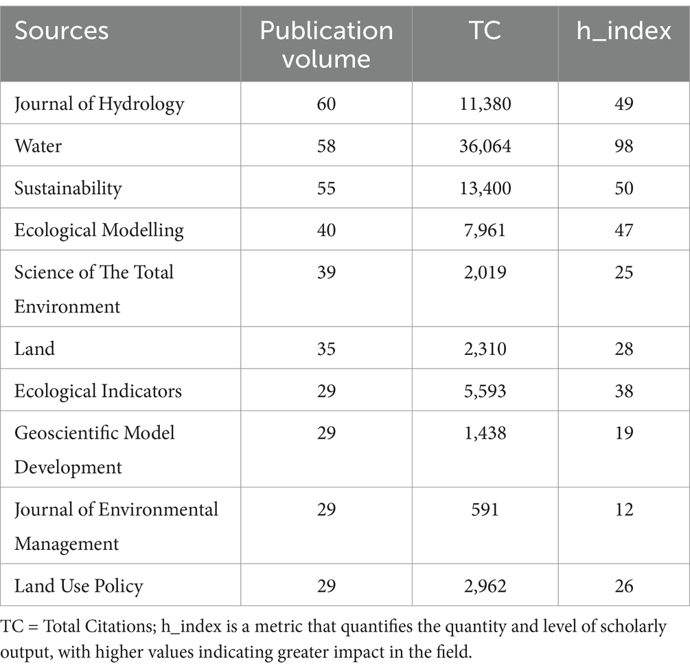
Table 1. Provenance of the premier 10 journals ranked by publication volume within the period spanning 1988 to 2023.
Among the top 10 journals in terms of publication volume, journals such as Ecological Modelling (in ecological model development, the SEMLUC model), Geoscientific Model Development (in model methodology innovation, such as the improvement of the CA model), and Sustainability (in multi-scenario simulation models, such as CLUE-S and FLUS) place greater emphasis on model research. Journals that focus more on environmental impact research include Journal of Hydrology (impacts on the hydrological environment, such as flood frequency), Water (comprehensive impacts of hydrology and climate), Science of The Total Environment (comprehensive environmental effects, such as the value of ecosystem services), Land (impacts on ecosystem services, such as ESV assessment), and Ecological Indicators (quantification of ecological indicators, such as biodiversity and carbon storage). In contrast, Journal of Environmental Management, and Land Use Policy involve models that serve policy or management objectives. They emphasize application-oriented impact analysis, and attach equal importance to models and environmental impacts.
An investigation into the growth rates of the top five journals gauged by publication volume divulges that the Journal of Hydrology and Ecological Modelling evince relatively elevated overall growth rates, occupying the first and second positions, respectively. Conversely, Water, Sustainability, and the Science of The Total Environment have witnessed an expedited growth tempo subsequent to 2010, eclipsing Ecological Modelling by 2021. Furthermore, the growth rate of the Journal of Hydrology is currently manifesting a tendency of being superseded by Water and Sustainability (Figure 2).
At present, a cumulative total of 622 journals have disseminated 2,147 articles associated with the simulation and prediction of land use change. The publication frequencies across diverse journals are circumscribed within a range of 60 articles. The top 10 journals, in aggregate, have furnished 403 articles, which accounts for less than one-fifth of the entire corpus. Notably, no pronounced predilection for specific journals is discernible. However, in the general panorama, the five journals with the most prolific publication records are the Journal of Hydrology (60 articles), Water (58 articles), Sustainability (55 articles), Ecological Modelling (40 articles), and the Science of The Total Environment (39 articles). Of particular salience is the fact that the Journal of Hydrology, Water, and Sustainability have amassed citations numbering in the tens of thousands, with Water alone aggregating over 36,000 citations. Correspondingly, the h-index values, emblematic of the academic productivity and influence of articles within these three journals, stand as the highest among all journals. This circumstance intimates that articles published in these journals have elicited extensive attention and acclaim (Table 1).
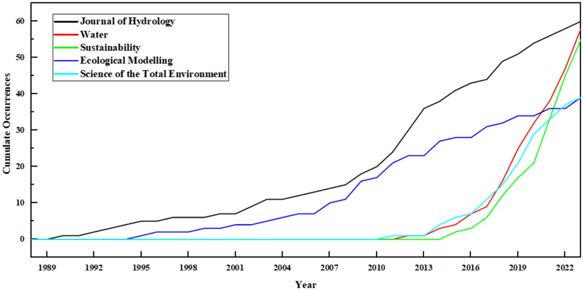
Figure 2. Growth curve of journal sources for land use change simulation predictions.
4.2 Pivotal research countries and institutional analysis
In this paper, the Walktrap clustering algorithm was utilized to scrutinize the collaborative networks of the top 50 countries and institutions. The Walktrap algorithm, which is founded on the principle of random walks, is efficacious in discerning community structures within networks (Xie et al., 2020). With the aim of identifying the pivotal countries and research institutions that have exerted a substantial influence on the field of land use change simulation and prediction, an in-depth exploration of the collaborative networks among countries and institutions was conducted (Figures 3, 4). Since the inception of research in this domain, 2,530 institutions from 78 countries or regions have partaken in studies related to the simulation and prediction of land use change. In terms of the volume of publications, China takes the lead with 573 papers, trailed closely by the United States and Germany, which have contributed 382 and 162 papers, respectively (Table 2). Moreover, the publication outputs of seven countries, namely the United Kingdom, Australia, Canada, Japan, Brazil, France, and the Netherlands, are also deserving of attention, as each has published more than 50 papers. To gain a more comprehensive understanding of the extent of academic collaboration among countries, this paper analyzed the quantity of co-authored papers by authors of the same nationality (SCP) and the quantity of co-authored papers with authors from other countries (MCP). On the basis of this analysis, the ratio of international collaboration (MCP_Ratio) was computed. France exhibits the highest international collaboration ratio, with the United Kingdom following closely in second place. Japan, New Zealand, and Brazil complete the top five. Intriguingly, despite their high publication volumes, China and the United States display relatively lower ratios of international collaboration, ranking at the lower end. This could potentially be attributed to the sample size of the literature, leading to a dilution of the international collaboration ratio for these two countries. However, considering the results per se, both countries ought to enhance international collaboration within the academic sphere to foster knowledge exchange and mutual advancement.
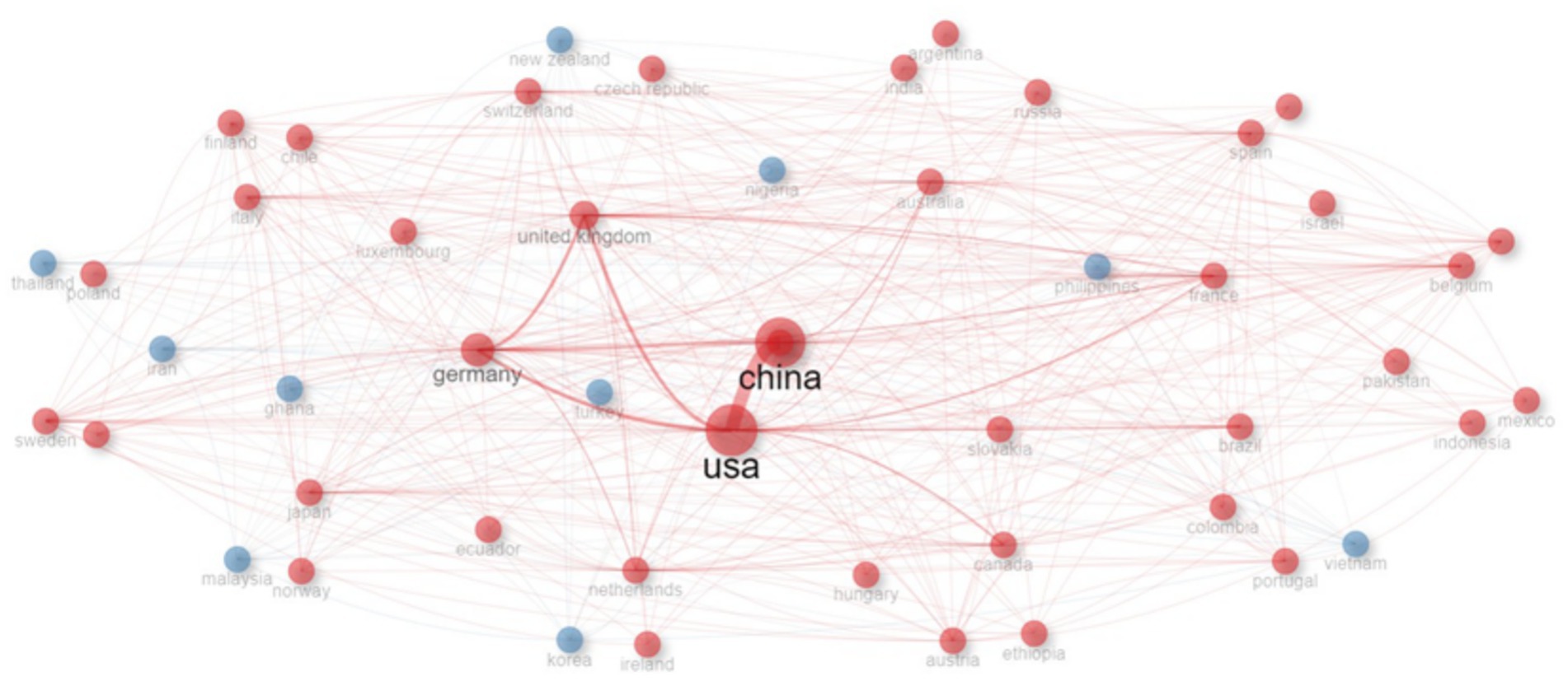
Figure 3. National cooperation network within the field of land use change simulation and prediction (LUCD) during the period from 1988 to 2023.
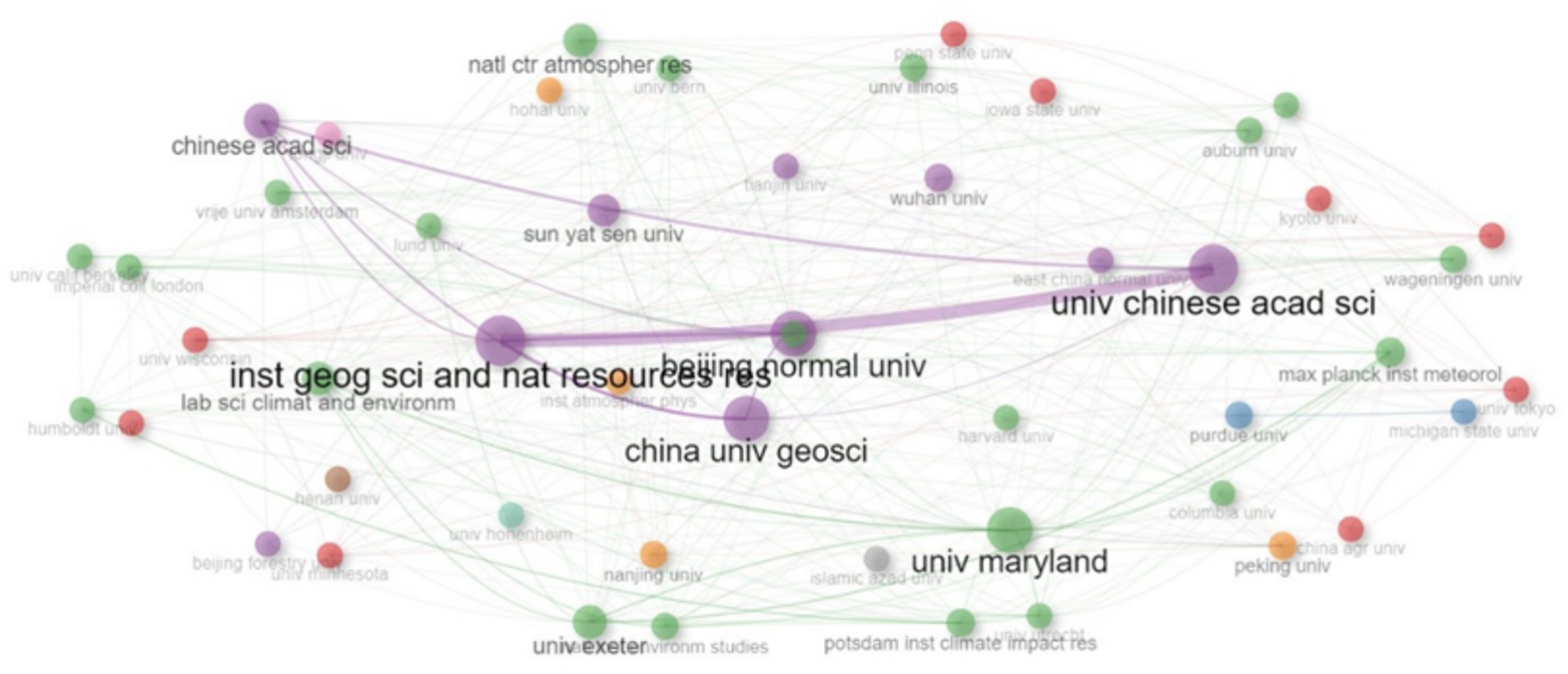
Figure 4. Institutional cooperation network within the realm of land use change simulation and prediction during the interval from 1988 to 2023.
The national collaborative network graph (Figure 3), computed via the Walktrap clustering algorithm, proffers a more perspicuous manifestation of the degree of proximity in collaboration among countries. The connections between the United States and China, both of which boast high publication volumes, are conspicuously close. Moreover, Germany also sustains relatively extensive academic exchanges with these two countries. Additionally, the academic collaboration between the United States and the United Kingdom is relatively tight. Notwithstanding China’s remarkable accomplishments in terms of publication quantity, it is of paramount importance to acknowledge that, within the domain of international collaborative networks, the United States retains a certain edge. This can likely be ascribed to the global eminence and influence of the scientific research and academic exchange system in the United States, which attracts a substantial number of international scientists and institutions for collaborative undertakings. China should persist in fortifying its collaborations with countries across the globe, inspiring research institutions to partake in extensive exchanges with their international counterparts, thereby making contributions to the progression of global technological innovation.
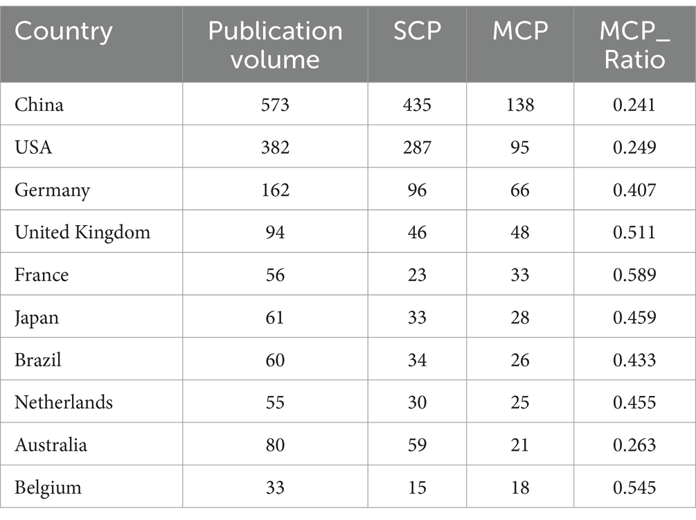
Table 2. Enumeration of national publications within the realm of land use change simulation and prediction during the period from 1988 to 2023.
In the examination of contributing institutions, conspicuous contributions were discerned from Beijing Normal University, China University of Geosciences, and the Institute of Geographic Sciences and Natural Resources Research, Chinese Academy of Sciences. These three institutions yielded 110, 93, and 82 papers, respectively, thereby exemplifying their preeminent capabilities within this field and effectuating positive contributions to the progression of the discipline (Table 3). Furthermore, remarkable accomplishments were witnessed from Sun Yat-sen University, Wuhan University, University of Chinese Academy of Sciences, Purdue University, University of Maryland, and Nanjing University, all of which have disseminated 50 or more papers in this field. This manifestation reflects the elevated academic research benchmarks of these universities within this particular domain.
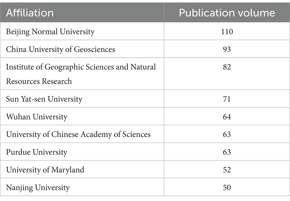
Table 3. Enumeration of publications issued by institutions within the field of land use change simulation and prediction during the period from 1988 to 2023.
Regarding inter-institutional collaboration, the Chinese Academy of Sciences demonstrates the utmost centrality within the collaborative network. It has fostered close affiliations with a multitude of institutions, including Beijing Normal University, China University of Geosciences, Sun Yat-sen University, and the University of Chinese Academy of Sciences. Of particular note, its collaboration with the Institute of Geographic Sciences and Natural Resources Research of the Chinese Academy of Sciences is especially salient, signifying the institute’s pivotal role within the research cooperation network and its possession of significant influence and allure. In terms of the intensity of collaboration between institutions, Beijing Normal University assumes the leading position, having established notably close relationships with the Institute of Geographic Sciences and Natural Resources Research, China University of Geosciences, and the University of Chinese Academy of Sciences. This underscores Beijing Normal University’s proficiency in aggregating high-quality resources from diverse esteemed academic institutions, facilitating academic exchanges and the generation of research achievements, thus making contributions to the progression of related disciplinary arenas. Concurrently, this also reflects the extensive recognition accorded to the university’s research directions, research standards, and innovative capabilities (Figure 4).
4.3 Keyword analysis
4.3.1 High frequency keyword analysis
An analysis was conducted on 2,147 research papers regarding land use change simulation and prediction that were published within the period from 1988 to 2023. A total of 5,269 author keywords were thereby identified. Figure 5 delineates the temporal trends of these author keywords. Specifically, the X-axis serves to denote the years, while the Y-axis represents the keywords. The blue bands signify the time interval during which the keywords garnered attention. Moreover, the magnitude of the dots reflects the frequency of keyword occurrences, with larger dots indicating a higher frequency of appearance.
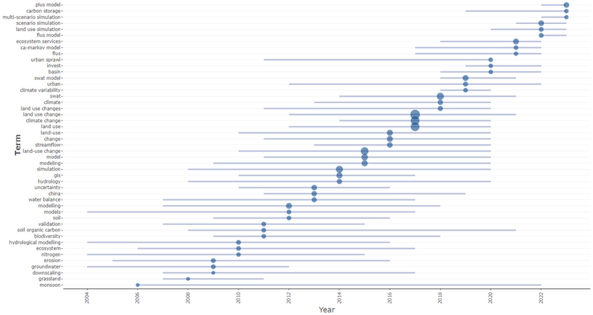
Figure 5. Temporal variation trend of author-defined keywords in the domain of land use change simulation and prediction (LUCD) during the period from 1988 to 2023.
The top 10 keywords, ranked in accordance with their frequencies, are as follows: “land use change,” “climate change,” “land use,” “land-use change,” “cellular automata,” “SWAT,” “simulation,” “model,” “urbanization,” and “modeling.” It is worth highlighting that “climate change” and “urbanization” have emerged as pivotal influencing factors within the context of land-use change simulation and prediction. Meanwhile, “cellular automata,” “SWAT,” “simulation,” “model,” and “modeling” epitomize the critical methodologies harnessed in the research. Additionally, “land use change,” “land use,” and “land-use change” encapsulate the principal thematic foci of these studies.
The proximity of the blue bands to the right-hand side in Figure 5 denotes the more recent publication timings of the corresponding author keywords, thereby mirroring the prevailing research trends. Over the past biennium, the key focal areas have encompassed “plus model,” “carbon storage,” “multi-scenario simulation,” “scenario simulation,” “land use simulation,” “flus model,” “ecosystem services,” “CA-Markov model,” and “flus,” all of which signify nascent research interests.
“Land Use Simulation” persists as a central tenet of research. The “Plus Model,” “FLUS,” “FLUS Model,” and “CA-Markov Model” exemplify specific categories of land-use change simulation models. These models amalgamate the influences of human activities and natural factors, integrating diverse data and scenario analyses to emulate and prognosticate the spatial configurations and dynamic processes of land-use change. “Multi-Scenario Simulation” and “Scenario Simulation” pertain to methodological approaches for forecasting the spatial patterns and dynamic transformations of future land use by postulating distinct hypothetical conditions. Such methods assist researchers in gleaning profound insights into the ramifications of various driving forces on land-use change. “Carbon Storage” is instrumental in deciphering the impact of disparate land-use types on carbon cycling and the potential contributions of land-use change to global climate change. “Ecosystem Services” denotes the manifold benefits and functions furnished by ecosystems to humanity, such as water conservation, climate modulation, and soil preservation. The study of ecosystem services facilitates the evaluation of the impact of land-use change on ecosystem functions and human wellbeing.
4.3.2 Keywords multiple correspondence analysis
The crux of the Multiple Correspondence Analysis concerning high-frequency keywords resides in the clustering and visualization of these keywords. In the visual representation, the closeness of the highlighted points mirrors the similarity among the keywords. Concurrently, keywords situated nearer to the central point signify elevated levels of attention, proffering an intuitive portrayal of the research directions and themes within a particular research domain. The outcomes suggest that the research directions and themes in the simulation and prediction of land-use change can be classified into four distinct categories (Figure 6).
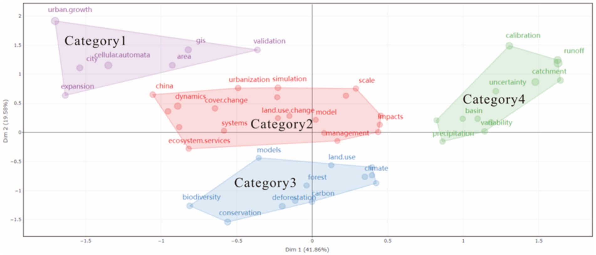
Figure 6. Multiple correspondence analysis of keywords within the domain of land use change simulation and prediction during the period from 1988 to 2023.
Category 1: Principally associated with urban expansion, the pertinent keywords encompass “urban growth,” “Cellular Automata,” “expansion,” “city,” “area,” and “GIS.” The confluence of “urban growth,” “Cellular Automata,” and “GIS” constitutes a comprehensive paradigm for apprehending and emulating urban development. Urban growth represents a complex and multifaceted phenomenon within the ambit of urbanization, encapsulating elements such as population dynamics, economic aspects, social fabric, and spatial configurations. It is customarily actuated by a plethora of factors, including economic incentives, population migrations, policy predispositions, and infrastructure advancements. Cellular Automata are especially apt for simulating the spatial dynamics of intricate systems. In the realm of urban studies, Cellular Automata disclose macroscopic patterns of urban growth by emulating the spatial interactions of discrete land-use decisions. The state transition of each cell is predicated on a set of rules that factor in the states of adjacent cells and sundry other determinants, thereby simulating the dynamic evolution of urban spatial structures. GIS, serving as a platform for amalgamating, dissecting, and visualizing geographic spatial data, can assimilate diverse data sources such as population census data, land-use data, and infrastructure particulars, furnishing requisite inputs for Cellular Automata models. Moreover, GIS can exhibit model outputs in the guise of maps and charts, empowering decision-makers to more efficaciously comprehend and interpret simulation outcomes within a spatial context. The interplay among urban growth as the research object, Cellular Automata as the modeling instrument for discerning and prognosticating this phenomenon, and GIS proffering technical underpinning for data integration, model execution, and result visualization engenders a cyclical relationship. This modus operandi not only augments our comprehension of the urban growth process but also furnishes a scientific foundation for formulating sustainable urban planning policies.
Category 2: Pertinent to land use change and its management, ecosystem services, as well as model simulation. The keywords comprise “China,” “dynamics,” “cover change,” “ecosystem services,” “systems,” “urbanization,” “model,” “management,” “land use change,” “scale,” “impacts,” and “simulation.” Land use change constitutes a pivotal determinant in instigating alterations in ecosystem services. Prudent land use planning and management initiatives possess the potential to attenuate the adverse consequences of land use change on ecosystem services and, in certain instances, even augment the capacity to furnish specific services. As an illustration, management strategies such as safeguarding critical ecological zones, effectuating reforestation endeavors, and instituting ecological corridors can uphold or augment the integrity and connectivity of ecosystems, thereby guaranteeing the continuous provision of ecosystem services. The formulation of land use change models to mimic future trajectories under diverse scenarios can efficaciously engender more scientifically-grounded management stratagems.
Category 3: Predominantly associated with the influencing factors of land use change, such as climate, biodiversity, and land degradation. The relevant keywords encompass “land use,” “conservation,” “models,” “climate,” “forest,” “biodiversity,” “carbon,” and “deforestation.” In recent years, there has been a burgeoning body of research focusing on the relationship between climate change and land use. This relationship is inherently bidirectional. On the one hand, land use change, particularly large-scale deforestation and urbanization, has the propensity to trigger an augmentation in atmospheric greenhouse gases, consequently hastening the pace of climate change. Conversely, climate change can also exert an impact on the patterns and efficiency of land use. For instance, extreme climatic events, such as floods and droughts, may disrupt agricultural land and infrastructure, thereby impinging on the sustainability of land use.
Category 4: Chiefly relevant to the accuracy, validation, and prediction aspects of hydrological models within the context of land use. The keywords consist of “precipitation,” “validation,” “basin,” “calibration,” “uncertainty,” “catchment,” and “runoff.” To guarantee the precision and dependability of the model, a comprehensive assessment of the model’s performance has emerged as a focal point in forthcoming research endeavors.
The emergence of emerging keywords signals that land-use change simulation is shifting from single-factor analysis to multi-dimensional coupling research. In the future, it is necessary to focus on exploring the following aspects: ① The cross-scale linkage mechanism between carbon storage and ecosystem services (ranging from plot-scale to watershed-scale); ② The dynamic coupling methods of socio-economic and natural elements in multi-scenario simulations; ③ The techniques for quantifying model uncertainty and data assimilation (such as calibrating model parameters with remotely sensed inversion data). These studies will deepen the understanding of the complexity of the land-use system and provide more precise decision-making support for sustainable development goals (such as SDG15 for terrestrial ecological protection).
4.4 Analysis of highly cited papers
The local citation rankings of the top 10 papers epitomize the most exemplary and influential research within the domain of land-use change simulation and prediction (Table 4). All of the 10 publications primarily concentrate on model simulations, with a preponderant utilization of the CLUE and CA models. The publication that has garnered the highest number of citations is titled “Neural-network-based cellular automata for simulating multiple land use changes using GIS” (Li and Yeh, 2002). This article presents a novel methodology for simulating multiple land-use changes by integrating neural networks with cellular automata and leveraging GIS. The crux of this approach lies in the employment of a three-layer neural network equipped with multiple output neurons to compute the transition probabilities for diverse land-use competitions. The model exploits the iterative cycle of the neural network to mimic the gradual process of land-use conversion. Given the dynamic updates occurring at the conclusion of each cycle, which give rise to indeterminate spatial variables, the article harnesses GIS to obtain site attributes and training data, thereby providing spatial functions for the construction of the neural network. Subsequently, the parameter values for the modeling are generated automatically through the training process of the neural network. This model has been successfully applied to simulate land-use changes in rapidly developing regions. By addressing the challenges associated with defining simulation parameter values, conversion rules, and model structure, which are inherent in traditional CA models due to the plethora of spatial variables and parameters required, this paper has been widely cited and referred to within the academic community.
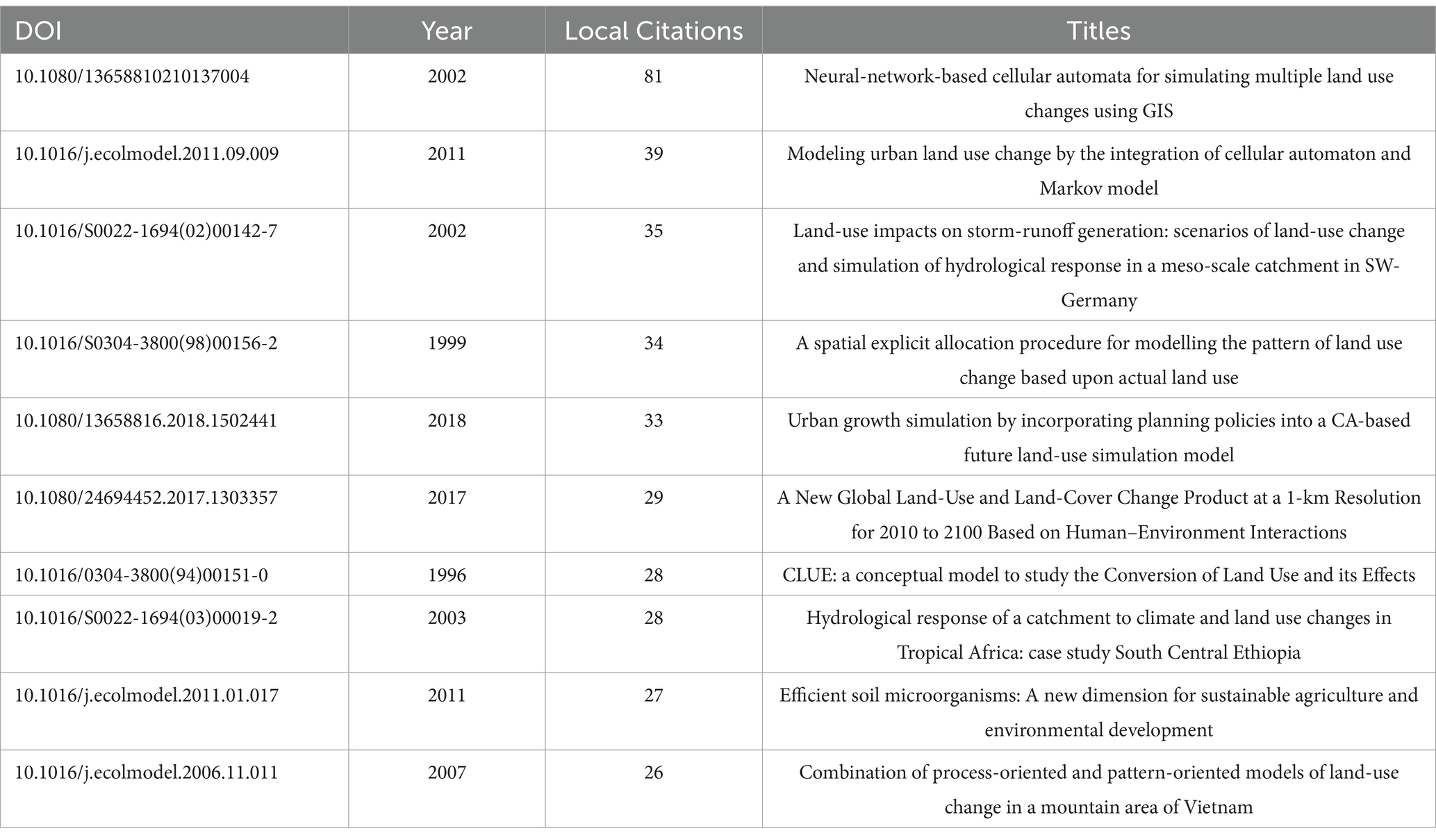
Table 4. The top ten locally cited articles in the field of land use change simulation and prediction from 1988 to 2023.
The second paper that has received a relatively high number of local citations is titled “Modeling urban land use change by the integration of cellular automaton and Markov model” (Guan et al., 2011). This article possesses the potential to facilitate local authorities in attaining a more profound understanding of and effectively addressing the complex issues prevalent within land-use systems. Furthermore, it contributes to the formulation of enhanced land-use management strategies, thereby enabling a more favorable equilibrium to be achieved between urban expansion and ecological conservation. The principal emphasis of the study is placed upon the spatial land-use model that integrates the cellular automaton and the Markov model. This model undertakes an analysis of the spatio-temporal patterns of land use in Saga, Japan, with respect to natural and socio-economic factors. Initially, GIS technology is employed to compute the alterations in land-use area as well as its spatial distribution. Subsequently, the study delves into the transitions among different land-use types, resulting in the generation of a transition matrix for the period spanning from 1976 to 2006. Concurrently, a comprehensive evaluation program, which incorporates natural and socio-economic data, is utilized to produce a transition potential map. Secondly, by leveraging both the transition potential map and the transition matrix, the study establishes a Markov cellular automaton model to simulate the spatial distribution of land use in 2006 and to predict the land-use changes that are anticipated to occur from 2015 to 2042. Consequently, researchers have widely referred to and further expanded upon the model presented in this article with the aim of achieving its continued optimization.
The third paper with a significant citation count, namely “Land-use impacts on storm-runoff generation: scenarios of land-use change and simulation of hydrological response in a meso-scale catchment in SW-Germany” (Niehoff et al., 2002), has received extensive referencing on account of its in-depth exploration into the influence exerted by land-use change on storm-runoff generation. The article deploys the Land Use Change Modeling Toolkit (LUCK) as a methodological instrument. LUCK offers an approach to spatially translate the overall trend of land-use change into scenarios of the spatial distribution of land-use patterns, taking into consideration its topological structure within a true location model. By evaluating site characteristics and neighborhood relationships, the spatial determination of the allocation of land-use categories for each grid cell is achieved. Utilizing these land-use scenarios, the study employs a modified version of the physically based hydrological model WaSiM-ETH to simulate the impact of altered land-use characteristics on floods. To augment the model’s capabilities and aptly represent the runoff generation mechanisms related to land use, supplementary mechanisms are incorporated. These include a large-pore module that accounts for rapid infiltration processes, a sedimentation module that reduces soil surface water conductivity as a function of precipitation intensity and vegetation cover, and the consideration of sub-grid variability in the impermeable and sealed portions of grid cells. With these enhancements, the model is successfully applied to a meso-scale watershed in southwest Germany. Consequently, the article proffers a reliable and robust model approach for investigating the relationship between land-use change and the hydrological cycle, thereby attracting widespread citations from the research community. In the top 10 most frequently cited research papers, the majority propose methods for model prediction. This underscores the significance of employing predictive models to anticipate future trends and outcomes. Model prediction methods allow for in-depth analysis and exploration of historical data, revealing latent relationships and patterns among data, thereby demonstrating a high level of scientific rigor and reliability. Re-searchers can flexibly adjust and optimize these methods based on different data types and research objectives, ensuring a high degree of applicability and flexibility. As a result, model prediction approaches have been widely embraced in various applications.
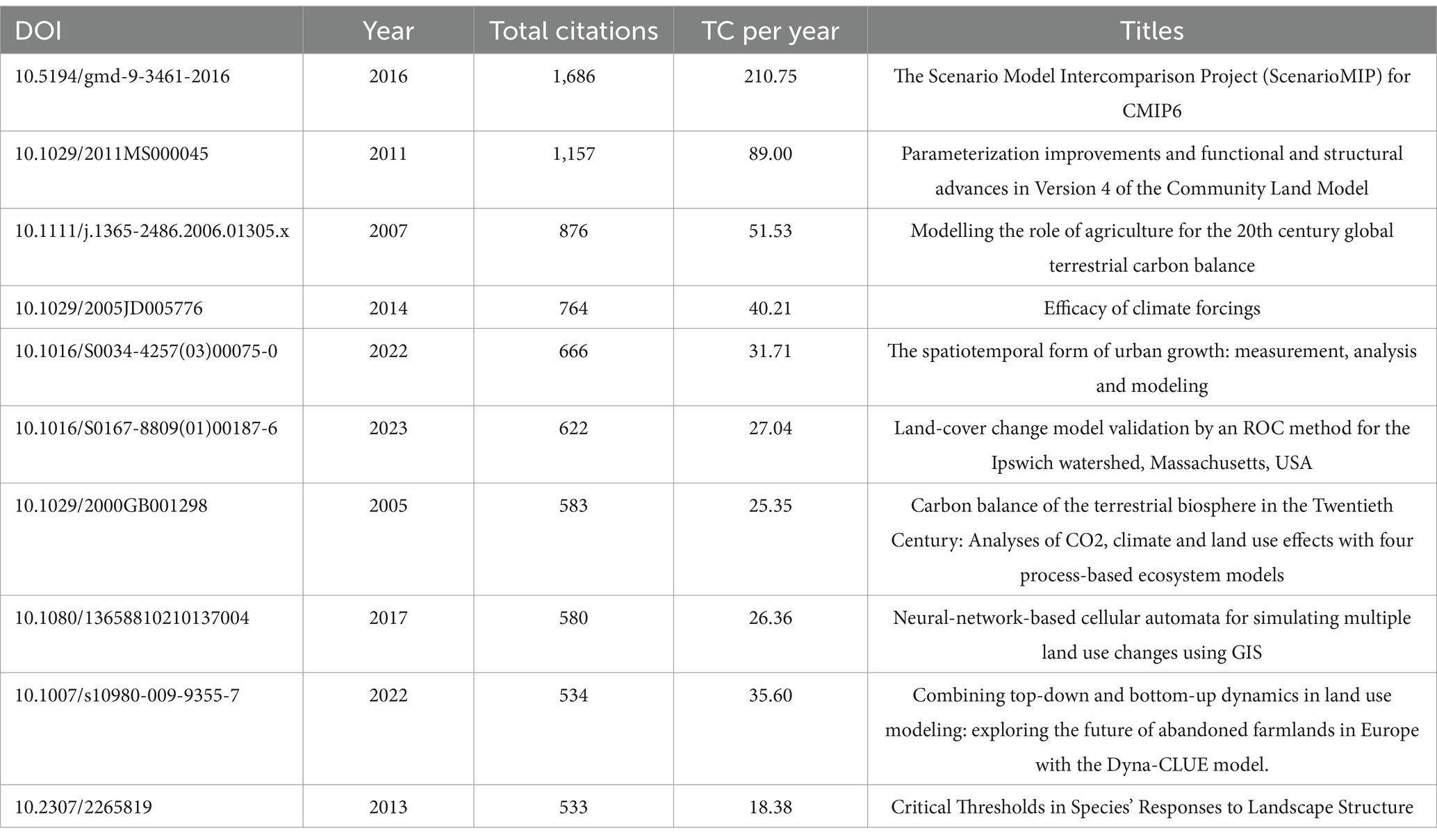
Table 5. The top 10 cited articles in the world in the field of land use change simulation and pre-diction from 1988 to 2023.
In the domain of land use change simulation and prediction, two papers have each accrued over 1,000 citations (Table 5). The first paper, titled “The Scenario Model Inter-comparison Project (ScenarioMIP) for CMIP6,” has been cited 1,686 times. This article furnishes multi-model climate predictions that are predicated on alternative scenarios of future emissions and land use changes, which have been comprehensively evaluated. These predictions were provided to the climate modeling groups prior to the end of 2016 (O'Neill et al., 2016).
The second paper, namely “Parameterization Improvements and Functional and Structural Advances in Version 4 of the Community Land Model” (Lawrence et al., 2011), has also been cited 1,686 times. This paper primarily focuses on the CLM4 model, which is founded upon a carbon-nitrogen biogeochemical model. The CLM4 model has been fortified with several notable features, including the urban canyon model, transient land cover, and enhancements in land use change. These augmentations facilitate the exploration of more intricate interactions between land and climate.
From the perspective of research content, locally highly cited papers focus on simulating the land-use dynamics in specific regions, emphasizing the resolution of region-scale specific issues. For instance, they investigate the impact of land-use changes in a certain German river basin on hydrology. These papers also highlight the influence of local policies and ecological constraints on land use, aiming to optimize regional land management. Moreover, they pay attention to integrating specific driving factors into models to improve simulation accuracy. Common keywords include cellular automata, GIS, etc., and the simulations are often based on models such as cellular automata combined with regional data.
In contrast, globally highly cited papers tend to concentrate on researching the impacts and mechanisms of land-use change at the global or trans-regional levels. For example, they explore the effects on the global carbon budget and the climate system, and establish trans-regional comparison frameworks. Additionally, these papers are dedicated to multi-model integration and methodological innovation, aiming to address the uncertainties of global models and the issues of interdisciplinary integration. This involves activities such as global climate model comparison and the development of Earth system models, and makes more use of macroscopic research methods like multi-model integration and meta-analysis.
These differences primarily stem from variations in research objectives. Local studies aim to solve practical regional problems, while global research focuses on global macroscopic laws and universal methods. There are also distinctions in data acquisition and research scales. It is relatively easy for local research to obtain high-resolution regional data for micro-scale studies, whereas global research depends on multi-source global data for macroscopic analysis. Additionally, the requirements for disciplinary development vary. Local research centers on the application of regional models and technological improvements, while global research emphasizes interdisciplinary integration and the construction of macroscopic frameworks.
4.5 Analysis of the evolution of research hotspots
Considering the ascending trend in the quantity of publications within the field of land use change simulation and prediction, the years 2000 and 2016 have been chosen as temporal demarcations, thereby partitioning the research period into three separate stages. The analysis regarding the evolution of research development over time is illustrated in Figure 7. There is a progressive reduction in the number of keywords, which suggests a tendency toward more consolidated research directions. The keyword “dynamics” remains prevalent throughout the entire period, thereby underlining the centrality of “change” within the context of simulating and predicting land use changes. Moreover, the keyword “model” emerges in the latter two periods, accentuating the importance of modeling predictions within the domain of land use change forecasting.
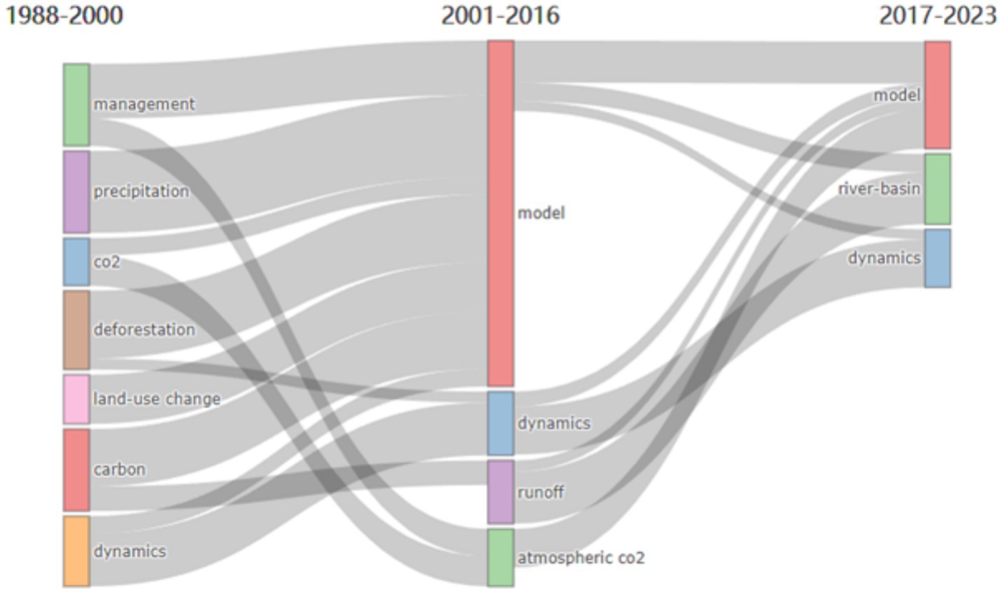
Figure 7. Thematic evolution in the field of land-use change modeling and fore-casting, 1988–2023.
The keywords characteristic of the period 1998–2000 comprise “management,” “precipitation,” “CO2,” “carbon,” “land-use change,” “deforestation,” and “dynamics.” During this interval, notwithstanding the relatively meager number of published papers, the keyword diversity stands as the highest among the three stages under consideration. This phenomenon implies that research pertaining to land use change simulation or prediction was in its nascent and exploratory phase. The investigations conducted during this period encompassed a gamut of topics, such as land use management and the correlation between natural environmental conditions and land use (Hall et al., 1995). Scholars at this stage predominantly centered their attention on modeling the influencing factors and predictive capabilities. For example, Lambin et al. (Lambin et al., 2000) undertook a comparison of diverse modeling methodologies employed in land use/land cover change research from the vantage point of studying and prognosticating the efficacy of intensified land use changes. The findings suggested that dynamic, process-based simulation models are more conducive to predicting alterations in land use intensity in contrast to empirical, stochastic, or static optimization models. Nevertheless, certain stochastic and optimization techniques can prove valuable in delineating the decision-making processes that underpin land management. The article further accentuated the necessity to factor in the specific geographical and socio-economic milieu of the study, the spatial scale, and their ramifications on the modeling approaches, as well as temporal aspects, including the distinction between dynamic and equilibrium models, thresholds and outliers associated with rapid changes, and system feedback. Given the capricious nature of specific driving forces, the majority of modeling endeavors were recommended to concentrate on scenario analysis, taking into account the uncertainties inherent in the driving forces.
The period before 2000 witnessed the germination of the sustainable development concept and the foundation-laying of model methodologies. In 1992, the United Nations Conference on Environment and Development (the Rio de Janeiro Summit) put forward Agenda 21, emphasizing the importance of sustainable management of land resources. This directly propelled “management” and “land use change” to become early core keywords. During the same period, the global land degradation intensified (for example, reports from the Food and Agriculture Organization of the United Nations indicated that one-quarter of the global land was degraded), giving rise to keywords such as “deforestation,” “carbon,” and “CO₂,” which reflect ecological and environmental issues. This demonstrated the initial attention to the linkages between land-use change, the carbon cycle, and the climate system. Moreover, Geographic Information System (GIS) and Remote Sensing (RS) technologies gradually matured in the 1990s, enabling spatially explicit simulation of land-use change.
During the period from 2000 to 2016, the quantity of keywords diminished from 7 to 4, specifically “Model,” “dynamics,” “runoff,” and “atmospheric CO2.” Apart from “dynamics” and “CO2,” the remaining keywords metamorphosed into “Model” and “runoff,” with “Model” assuming the preponderant focus. This transformation signals a redirection of the research emphasis toward models within this timeframe. For instance, Tsang and Leung (2011) devised a cellular automaton (CA) predicated on the theoretical framework of urban land use change and other local circumstances. This methodology incorporates the theory explicating urban land rent differentials and the external conditions reflective of urban development into CA for the simulation of land use changes. Li et al. (Li et al., 2012) proffered a technique for simulating land use change founded on a Graphics Processing Unit (GPU)-accelerated CA. This approach is especially efficacious for large-scale regional (i.e., provincial or national) land use change simulations. The proposed method amalgamates the latest GPU high-performance computing technology with CA technology and employs model mapping procedures, culminating in a computational speed 30-fold swifter than that of traditional methods.
The period from 2000 to 2016 represented a crucial stage of accelerated urbanization and breakthroughs in model technology. At the beginning of the 21st century, the global urbanization rate exceeded 50%. Rapid urbanization in regions such as China and Southeast Asia led to arable land loss and increased ecological pressure (for example, the expansion of construction land in the Pearl River Delta), giving rise to keywords like “urbanization,” “urban growth,” and “model.” To meet the demand for simulating urban expansion, coupled models such as CA-Markov were widely applied (as demonstrated by the case of Saga City, Japan), making “model” a core methodological keyword. In 2007, the Fourth Assessment Report of the Intergovernmental Panel on Climate Change (IPCC) clearly defined the impact of human activities on the climate system, prompting research to shift toward the hydrological and climate effects of land-use change. For instance, studies in the southwestern river basins of Germany focused on the impact of land-use change on storm runoff. Keywords such as “runoff” and “atmospheric CO₂” reflected the attention given to climate feedback mechanisms. Meanwhile, the emission reduction targets of the Kyoto Protocol spurred an increase in research related to “carbon storage,” although it had not yet become a high-frequency keyword. During this time, the improvement in computer computing power supported the development of complex models. For example, the GPU-accelerated CA model increased the simulation efficiency by 30 times, keeping technical keywords such as “cellular automata” and “Markov model” continuously active (Li et al., 2012).
In the period spanning from 2017 to 2023, while “Model” and “dynamics” were retained, the other keywords transitioned to “river-basin.” During this interval, a substantial focus was still placed on modeling investigations. For example, Mujiono et al. (2017) employed a CA-Markov model to prognosticate land use changes in 2035 and their implications for deforestation. This modeling paradigm is of paramount importance for deciphering the dynamic causal relationships and effects of land use changes. Wu et al. (2020) implemented a Logistic-CA-Markov model to simulate the high temporal and spatial resolution land use change patterns in the Jiaodong Peninsula for the years 2010, 2015, and 2020. Beyond modeling, there has been a gradual emergence of research on related topics such as “ecosystem services.” For instance, Lou et al. (2022) posited that comprehending the patterns and processes of land use change is conducive to enhancing the global ecological environment and fostering the coordinated development of human-land relationships. Lou et al. simulated the impact of land use changes in the Yangtze River Delta on ecosystem service values (ESV) under multiple scenarios. They conducted a comparative analysis of ESV under diverse scenarios, furnishing guidance and a scientific foundation for promoting global basin ecological civilization construction and high-quality development.
The years from 2017 to 2023 witnessed an era of multi-dimensional integration driven by ecological security imperatives and global governance objectives. In 2015, the Paris Agreement set the target of carbon neutrality, and in 2021, China introduced its “dual-carbon” policy. These developments propelled “carbon storage” and “ecosystem services” to the forefront as emerging research foci. Research predominantly centered on the valuation of ecosystem services (for instance, multi-scenario simulations in the Yangtze River Delta) and the optimization of land use for carbon sequestration. Keywords such as “multi-scenario simulation” and “FLUS model” exemplified model innovations spurred by policies. The ecological degradation of global river basins (exemplified by water scarcity in the Mekong River Basin) and policies in China like the “Yangtze River Protection Initiative” and the “Ecological Conservation of the Yellow River Basin” rendered “river-basin” a frequently-used keyword. During this period, the application of big data (such as multi-temporal remote-sensing data) and machine-learning technologies (such as geographically weighted regression) fostered methodological innovations like “geographically weighted” and “multi-source data fusion.” These advancements enhanced the adaptability of models to non-linear driving factors, including policy interventions and market fluctuations.
The shift of research hotspots is essentially the result of the combined effects of social needs, technological advancements, and environmental crises. In the future, it is necessary to further strengthen the collaborative modeling of “policy-technology-ecology” to provide more precise scientific support for global sustainable development goals.
5 Discussion
5.1 Land use change simulation and prediction future research directions
Over the period from 1988 to 2023, the domain of land use change simulation and prediction has witnessed a remarkable acceleration in its development. Nevertheless, upon a retrospective examination of the research history within this field, this paper identifies that it remains confronted with numerous challenges.
Firstly strengthen the coupling and integration of multiple models. Utilize model linking methodologies such as model nesting or coupling with climate change models, economic policy models, physical process models, machine learning models, and deep learning models. Realize synergistic effects among disparate models while guaranteeing standardized model interfaces to facilitate seamless data exchange. Implement dynamic interactions between models through parameter transfer and data sharing mechanisms. Moreover, employ data assimilation techniques to combine observational data from diverse sources and with varying levels of accuracy with model simulation results. Utilize optimization algorithms, such as Kalman filtering or its derivatives, to augment the accuracy and reliability of simulation outputs. Harness the advantages of various models to construct more comprehensive and practically applicable land use change simulation models.
Secondly augment the Spatiotemporal Resolution and Simulation Precision of Data. For the enhancement of resolution, an efficacious strategy entails the integration of multiple data sources. For example, the amalgamation of high spatial resolution panchromatic imagery with low spatial resolution multispectral imagery can yield images possessing both high spatial resolution and abundant spectral information. An alternative approach is to extract stable characteristics from multi-source and multi-temporal remote sensing big data. By employing these stable characteristics as a reference, diverse types of errors or model parameters can be estimated or jointly estimated, thereby enhancing the accuracy and stability of remote sensing data products.
Furthermore, matrix decomposition and optimization data processing algorithms should be employed. Matrix decomposition involves optimizing resolution through the decomposition and reconstruction of matrices from the original image, utilizing techniques such as Singular Value Decomposition (SVD) and Principal Component Analysis (PCA). Optimization data processing, on the other hand, concentrates on accelerating data processing and augmenting accuracy. This can be achieved, for instance, through parallel computing, distributed computing, and cloud computing technologies.
This is also worthy of attention that integrate a Broader Range of Land Use Change Driving Factors into Models. In the context of land use change simulation and prediction, a comprehensive consideration of diverse driving factors plays a pivotal role in enhancing simulation accuracy and prediction precision. Employ methodologies and technologies, including but not limited to multidimensional data analysis, GIS techniques, remote sensing and Earth observation data, socio-economic and policy analysis, model integration, uncertainty analysis, case studies and comparisons, as well as interdisciplinary collaboration, to effectively disclose and comprehend the driving mechanisms underlying land use change.
5.2 Research and practical implications
This study systematically reviewed the research context in the field of global land-use change simulation through bibliometric analysis. The findings of this research hold multiple practical implications for scientific research practices and work in related fields.
At the level of scientific research methodology, the trend of “multi-model coupling and technological integration” revealed by this study provides a clear pathway for subsequent research. Currently, mainstream models such as CA (Cellular Automata) and CLUE (Conversion of Land Use and its Effects at Small regional extent) have limitations in terms of simulation accuracy and the integration of driving factors. However, this study points out that composite modeling methods combining Markov chains, machine learning algorithms, and geographically weighted models (such as the CA-Markov and FLUS models) can more accurately capture the spatio-temporal heterogeneity of land-use changes. This inspires researchers to break through the technical boundaries of single models. By means of model nesting (for example, coupling climate models with land-use models) and multi-source data fusion (integrating remote sensing images, socio-economic data, and policy parameters), they can construct simulation frameworks that are closer to reality. Such frameworks have particular application potential in complex scenarios, including ecological protection of river basins and the regulation of urban expansion.
At the practical application level, the identified direction of “aligning multi-scenario simulation with sustainable development goals” in this study has direct guiding significance for land resource management. For example, when it comes to the assessment of land carbon storage under the “carbon neutrality” goal, one can draw on the research paradigms associated with emerging keywords such as “carbon storage” and “ecosystem services” in this study. By setting different land use policy scenarios (such as converting farmland to forest and compact urban development), the impacts of these scenarios on the carbon cycle and biodiversity can be simulated, providing a quantitative basis for regional territorial spatial planning. Moreover, the study has found differences in international cooperation among major countries such as China and the United States (for instance, China has a high output of papers but a relatively low international collaboration rate). This indicates that countries need to strengthen the construction of cross-regional research networks, especially in areas sensitive to land use changes such as those along the Belt and Road Initiative. Through sharing remote sensing data and policy model parameters, the universality of simulation results and their value as a reference for decision-making can be enhanced.
In terms of interdisciplinary integration and technological transformation, the technical pathways outlined in this study, such as the “deep integration of remote sensing technology and Geographic Information System (GIS)” and “optimizing simulation parameters through machine learning,” offer entry points for collaboration for interdisciplinary teams. For example, collaboration between environmental science and computer science can focus on developing automated model calibration tools, utilizing deep learning algorithms to optimize the conversion rules of the Cellular Automata (CA) model. The intersection of economics and geography, on the other hand, can explore models for assessing the impact of land-use changes on regional economic efficiency, thereby facilitating the efficient allocation of land resources under the “dual-carbon” goals.
In conclusion, this study not only provides researchers with directions for technological innovation (such as enhancing the spatio-temporal resolution of data and integrating socio-economic driving factors). Moreover, by revealing research hotspots and international cooperation models, it offers cross-scale solutions for policymakers and resource managers. This promotes the in-depth transformation of land-use change simulation from theoretical models to practical applications, thereby contributing to the achievement of global sustainable development goals.
5.3 Strengths and weaknesses
This study employed bibliometrix to conduct a comprehensive review and analysis of the literature within the domain of land use change simulation and prediction, thereby enabling a rapid understanding of the research status, hotspots, and trends therein. Citation analysis and co-word analysis, among other techniques, unveiled the research dynamics and the developmental context within the field of land use change simulation and prediction. Keyword analysis and cluster analysis, inter alia, indicated the potential research directions within this domain. Citation frequencies and impact factors, etc., were conducive to discerning the significant research achievements and the influential scholars or research teams in the field of land use change simulation and prediction, thus facilitating academic exchanges and collaborations.
This study is not without its limitations. Firstly, it exhibits a high degree of dependence on a real-time updated database. Consequently, the bibliometric analysis within this field is subject to variation over the passage of several years. Secondly, the present study solely utilized the Web of Science Core Collection database. While this database compiles high-quality and high-impact journals from across the globe, the incorporation of information such as patents and research funds from other databases might prove more advantageous for the research.
Subsequent research can involve the integration of multi-source data and cross-database analysis. By incorporating multiple databases such as Scopus and CNKI, and by paying attention to non-English literature, it is possible to reveal the characteristics of regional research and fill the gaps caused by language and database biases. Furthermore, a strategy of “term expansion + co-occurrence analysis” can be adopted. By combining natural language processing techniques and topic models, it is feasible to refine keyword design and conduct interdisciplinary mining, so as to identify emerging research areas. It is also necessary to explore the pathways for combining machine learning with traditional simulation models. By integrating remote sensing and socio-economic data, and developing a multi-dimensional driving factor analysis framework, the simulation accuracy can be improved, and the problem of insufficient coupling between natural and humanistic factors can be solved.
Taking “strengthening multi-model coupling and integration” as an example, this technical roadmap can be implemented in four stages. In the first stage (from the 1st to the 6th month, denoted as T1–T6), the construction of a standardized multi-source data sharing platform will be carried out. This involves integrating data such as remote sensing images, socio-economic data, climate data, and policy data, and conducting preprocessing. A unified data interface will be developed, and a distributed database will be constructed to enable real-time data retrieval across different models. Meanwhile, shared parameters and their transfer mechanisms will be defined. In the second stage (from the 7th to the 12th month, T7–T12), the coupling interfaces of core models will be developed. Specifically, two-way coupling between CA-Markov and InVEST, as well as between CLUE-S and CMIP6, will be achieved. Connectors will be developed using Python API interfaces and the Modelica language. In the third stage (from the 13th to the 18th month, T13–T18), multi-model integration and scenario simulations will be conducted. Taking the Yellow River Basin as a case study area, scenarios such as natural development, ecological priority, and climate adaptation will be designed. Through CLUE-S calibration rules, CA-Markov will be used to simulate the distribution of land use, InVEST will be employed to evaluate the value of ecosystem services, and the policy module will adjust parameters according to the evaluation results. In the fourth stage (from the 19th to the 24th month, T19–T24), the effectiveness evaluation and iterative optimization will be carried out. Quantifiable evaluation indicators will be set from aspects such as simulation accuracy, quantification errors of ecological effects, computational efficiency, and policy response capabilities. An error feedback mechanism and a dynamic adjustment algorithm for model weights will be established to continuously optimize the models.
6 Conclusion
This study undertook a comprehensive examination of 2,149 papers relevant to the domain of land use change simulation and prediction within the Web of Science Core Collection spanning from 1988 to 2023, by integrating bibliometric analysis and machine learning techniques. It delineated the trends in publications and prominent journals within this field, determined the collaboration networks among major research institutions and countries, analyzed influential articles and high-frequency keywords, and deliberated on future research directions and trends predicated on the evolution of research hotspots and themes in the field.
Over the past 37 years, the number of publications in the field of land use change simulation and prediction has experienced rapid growth, categorized into three phases: the budding phase from 1988 to 2000, the rapid development phase from 2001 to 2016, and the active phase from 2016 to 2023. The most influential journals include the Journal of Hydrology, Water, and Sustainability. China, the United States, and Germany emerge as major research countries, with Beijing Normal University, China University of Geosciences, and the Institute of Geographic Sciences and Natural Resources Re-search of the Chinese Academy of Sciences being primary research institutions. The study suggests that the field still faces numerous challenges, and future efforts may need to enhance multi-model coupling and integration technologies, exploiting the advantages of different models to develop more comprehensive and applicable land use change simulation models. Models should also incorporate more driving factors for land use change, such as social factors like policies, economics, and population, as well as natural environmental factors like climate and precipitation. Regarding existing imagery, improving data accuracy and stability can be achieved through the fusion of multi-source data or by mining stable characteristics from multi-source and multitemporal remote sensing big data, using these stable characteristics as a basis for estimating or jointly estimating model parameters for various types of errors.
Data availability statement
The raw data supporting the conclusions of this article will be made available by the authors without undue reservation.
Author contributions
QS: Conceptualization, Data curation, Formal analysis, Methodology, Software, Writing – original draft, Writing – review & editing. LH: Data curation, Software, Writing – review & editing. HM: Data curation, Methodology, Software, Writing – review & editing. LC: Data curation, Methodology, Software, Writing – review & editing. JW: Data curation, Methodology, Software, Writing – review & editing. XZ: Conceptualization, Funding acquisition, Writing – review & editing.
Funding
The author(s) declare that financial support was received for the research and/or publication of this article. This research was funded by The Third Xinjiang Scientific Expedition Program (Grant No. 2022xjkk0405). The Project of National Natural Science Foundation of China (Grant No.42271313).
Conflict of interest
The authors declare that the research was conducted in the absence of any commercial or financial relationships that could be construed as a potential conflict of interest.
Generative AI statement
The author(s) declare that no Gen AI was used in the creation of this manuscript.
Publisher’s note
All claims expressed in this article are solely those of the authors and do not necessarily represent those of their affiliated organizations, or those of the publisher, the editors and the reviewers. Any product that may be evaluated in this article, or claim that may be made by its manufacturer, is not guaranteed or endorsed by the publisher.
References
Aburas, M. M., Ahamad, M. S. S., and Omar, N. Q. (2019). Spatio-temporal simulation and prediction of land-use change using conventional and machine learning models: a review. Environ. Monit. Assess. 191:205. doi: 10.1007/s10661-019-7330-6
Bao, L., and Fritchman, J. C. (2018). Information of complex systems and applications in agent based modeling. Sci. Rep. 8:6177. doi: 10.1038/s41598-018-24570-1
Bornmann, L., and Marx, W. (2012). HistCite analysis of papers constituting the h index research front. J. Informet. 6, 285–288. doi: 10.1016/j.joi.2011.11.001
Bukar, U. A., Sayeed, M. S., Razak, S. F. A., Yogarayan, S., Amodu, O. A., and Mahmood, R. A. R. (2023). A method for analyzing text using VOSviewer. Methods 11:102339. doi: 10.1016/j.mex.2023.102339
Chen, R., and Kong, Y. (2023). A comprehensive review of greenhouse gas based on subject categories. Sci. Total Environ. 866:161314. doi: 10.1016/j.scitotenv.2022.161314
Crooks, A. T., and Castle, C. J. E. (2011). “The integration of agent-based modelling and geographical information for geospatial simulation” in Agent-based models of geographical systems. (Dordrecht, Heidelberg, London, and New York: Springer), 219–251. doi: 10.1007/978-90-481-8927-4
Domingo, D., Palka, G., and Hersperger, A. M. (2021). Effect of zoning plans on urban land-use change: a multi-scenario simulation for supporting sustainable urban growth. Sustain. Cities Soc. 69:102833. doi: 10.1016/j.scs.2021.102833
Dong, K, and Zhang, X R (2015). The research progress of conversion of land use and its effects at small region extent. 2015 3rd international conference on advances in energy and environmental science.
Elizabeth, P. (2022). Global land degradation serious, U.N. report finds, but restoration offers hope. Science. Available online at: https://www.science.org/content/article/global-land-degradation-serious-u-n-report-finds-restoration-offers-hope (Accessed April 27, 2022).
Guan, D. J., Li, H. F., Inohae, T., Su, W., Nagaie, T., and Hokao, K. (2011). Modeling urban land use change by the integration of cellular automaton and Markov model. Ecol. Model. 222, 3761–3772. doi: 10.1016/j.ecolmodel.2011.09.009
Guan, D. J., Zhao, Z. L., and Tan, J. (2019). Dynamic simulation of land use change based on logistic-CA-Markov and WLC-CA-Markov models: a case study in three gorges reservoir area of Chongqing, China. Environ. Sci. Pollut. Res. 26, 20669–20688. doi: 10.1007/s11356-019-05127-9
Hall, C. A. S., Tian, H., Qi, Y., Pontius, G., and Cornell, J. (1995). Modelling spatial and temporal patterns of tropical land use change. J. Biogeogr. 22, 753–757. doi: 10.2307/2845977
Hochreiter, S., and Schmidhuber, J. (1997). Long short - term memory. Neural Comput. 9, 1735–1780. doi: 10.1162/neco.1997.9.8.1735
Jafari, M., Majedi, H., and Monavari, S. M. (2016). Dynamic simulation of urban expansion through a CA-Markov model case study: Hyrcanian region, Gilan, Iran. Eur. J. Remote Sens. 49, 513–529. doi: 10.5721/EuJRS20164927
Lambin, E. F., Rounsevell, M. D. A., and Geist, H. J. (2000). Are agricultural land-use models able to predict changes in land-use intensity? Agric. Ecosyst. Environ. 82, 321–331. doi: 10.1016/S0167-8809(00)00235-8
Lamperti, F., Roventini, A., and Sani, A. (2018). Agent-based model calibration using machine learning surrogates. J. Econ. Dyn. Control. 90, 366–389. doi: 10.1016/j.jedc.2018.03.011
Lawrence, D. M., Oleson, K. W., Flanner, M. G., Thornton, P. E., Swenson, S. C., Lawrence, P. J., et al. (2011). Parameterization improvements and functional and structural advances in version 4 of the community land model. J. Adv. Model. Earth Syst. 3:27. doi: 10.1029/2011MS00045
Li, X., Hu, S., Jiang, L., Han, B., Li, J., and Wei, X. (2023). Bibliometric analysis of the research (2000-2020) on land-use carbon emissions based on CiteSpace. Land 12:165. doi: 10.3390/land12010165
Li, T., Jia, B., Zhang, Q., Liu, W., and Fang, Y. (2024). Scenario simulation of urban land use and ecosystem service coupling major function-oriented zoning. Ecosyst. Health Sustain. 10:0078. doi: 10.34133/ehs.0078
Li, D., Li, X., Liu, X. P., Chen, Y. M., Li, S. Y., Liu, K., et al. (2012). GPU-CA model for large-scale land-use change simulation. Chin. Sci. Bull. 57, 2442–2452. doi: 10.1007/s11434-012-5085-3
Li, S. C., and Song, W. (2023). Research progress in land consolidation and rural revitalization: current status, characteristics, regional differences, and evolution laws. Land 12:210. doi: 10.3390/land12010210
Li, X., and Yeh, A. (2002). Neural-network-based cellular automata for simulating multiple land use changes using GIS. Int. J. Geogr. Inf. Syst. 16, 323–343. doi: 10.1080/13658810210137004
Li, J. Y., Zheng, X. Q., and Zhang, C. X. (2021). Retrospective research on the interactions between land-cover change and global warming using bibliometrics during 1991-2018. Environ. Earth Sci. 80:573. doi: 10.1007/s12665-021-09804-2
Long, H. L. (2022). Theorizing land use transitions: a human geography perspective. Habitat Int. 128:102669. doi: 10.1016/j.habitatint.2022.102669
Lou, Y., Yang, D., Zhang, P., Zhang, Y., Song, M., Huang, Y., et al. (2022). Multi-scenario simulation of land use changes with ecosystem service value in the Yellow River Basin. Land 11:992. doi: 10.3390/land11070992
Matthews, R. B., Gilbert, N. G., Roach, A., Polhill, J. G., and Gotts, N. M. (2007). Agent-based land-use models: a review of applications. Landsc. Ecol. 22, 1447–1459. doi: 10.1007/s10980-007-9135-1
Mujiono,, Indra, T. L., Harmantyo, D., Rukmana, I. P., and Nadia, Z. (2017). “Simulation of land use change and effect on potential deforestation using Markov chain - cellular automata” in AIP Conf. Proc., vol. 1862. (Depok: AIP Publishing LLC), 030177.
Niehoff, D., Fritsch, U., and Bronstert, A. (2002). Land-use impacts on storm-runoff generation: scenarios of land-use change and simulation of hydrological response in a meso-scale catchment in SW-Germany. J. Hydrol. 267, 80–93. doi: 10.1016/S0022-1694(02)00142-7
Niu, L. D., and Pan, M. (2021). Research on dynamic simulation of land use change based on geographical weighted CLUE-S model. Int. J. Environ. Technol. Manag. 24, 49–61. doi: 10.1504/IJETM.2021.115728
O'Neill, B. C., Tebaldi, C., Van Vuuren, D. P., Eyring, V., Friedlingstein, P., Hurtt, G., et al. (2016). The scenario model intercomparison project (ScenarioMIP) for CMIP6. Geosci. Model Dev. 9, 3461–3482. doi: 10.5194/gmd-9-3461-2016
Rol, S. E. (2000). Modelling hydrological responses to land use and climate change: a southern African perspective. Ambio 29, 12–22. doi: 10.1579/0044-7447-29.1.12
Sankarrao, L., Ghose, D. K., and Rathinsamy, M. (2021). Predicting land-use change: intercomparison of different hybrid machine learning models. Environ. Model Softw. 145:105207. doi: 10.1016/j.envsoft.2021.105207
Shiono, T. (2021). Estimation of agent-based models using Bayesian deep learning approach of BayesFlow. J. Econ. Dyn. Control. 125:104082. doi: 10.1016/j.jedc.2021.104082
Susilo, B. (2019). The effect of spatial resolution on the performance of cellular automata-based land use changes spatial simulation. Sixth geoinformation science symposium. SPIE.
Tsang, S. W., and Leung, Y. A. (2011). Theory-based cellular automata for the simulation of land-use change. Geogr. Anal. 43, 142–171. doi: 10.1111/j.1538-4632.2011.00817.x
Valbuena, D., Verburg, P. H., Veldkamp, A., Bregt, A. K., and Ligtenberg, A. (2010). Effects of farmers’ decisions on the landscape structure of a Dutch rural region: an agent - based approach. Landsc. Urban Plan. 97, 98–110. doi: 10.1016/j.landurbplan.2010.05.001
Verburg, P. H., De Koning, G. H., Kok, K., Veldkamp, A., and Bouma, J. (1999). A spatial explicit allocation procedure for modelling the pattern of land use change based upon actual land use. Ecol. Model. 116, 45–61. doi: 10.1016/S0304-3800(98)00156-2
Wu, A., and Wang, Z. (2025). Multi-scenario simulation and carbon storage assessment of land use in a multi-mountainous city. Land Use Policy 153:107529. doi: 10.1016/j.landusepol.2025.107529
Wu, L, Zhu, M, Zhang, G, and Yang, R. (2020). Simulation of land use changes in Jiaodong peninsular based on the logistic-CA-Markov model. 6th annual international workshop on materials science and engineering, 1622, 012092.
Xie, H., Zhang, Y., Wu, Z., and Lv, T. (2020). A bibliometric analysis on land degradation: current status, development, and future directions. Land 9:28. doi: 10.3390/land9010028
Xu, X., Chen, Q. R., and Zhu, Z. H. (2022). Evolutionary overview of land consolidation based on bibliometric analysis in web of science from 2000 to 2020. Int. J. Environ. Res. Public Health 19:3218. doi: 10.3390/ijerph19063218
Xu, Q., Wang, Q., Liu, J., and Liang, H. (2021). Simulation of land-use changes using the partitioned ANN-CA model and considering the influence of land-use change frequency. ISPRS Int. J. Geo Inf. 10:345. doi: 10.3390/ijgi10050346
Xu, S., Wang, K., and Wang, F. (2025). Monitoring changes and multi-scenario simulations of land use and ecosystem service values in coastal cities: a case study of Qingdao, China. Environ. Monit. Assess. 197:193. doi: 10.1007/s10661-024-13556-4
Xu, B., and Yang, G. (2025). Interpretability research of deep learning: a literature survey. Inf. Fusion 115:102721. doi: 10.1016/j.inffus.2024.102721
Zhang, H., Zeng, Y., Zou, B., Xiao, P., Hu, D., and Peng, J. (2007). Quantitative analysis and simulation of land use changes in the Pearl River Delta. Geoinformatics :675236.
Zhao, S., Tu, K., Ye, S., Tang, H., Hu, Y., and Xie, C. (2023). Land use and land cover classification meets deep learning: a review. Sensors 23:8966. doi: 10.3390/s23218966
Zheng, F. Y., and Hu, Y. C. (2018). Assessing temporal-spatial land use simulation effects with CLUE-S and Markov-CA models in Beijing. Environ. Sci. Pollut. Res. 25, 32231–32245. doi: 10.1007/s11356-018-3189-2
Keywords: land use change, bibliometrics, prediction, simulation, models
Citation: Sun Q, Huang L, Meng H, Chi L, Wu J and Zhou X (2025) Review of simulations on land use change: a methodology based on bibliometric analysis. Front. Sustain. Food Syst. 9:1548565. doi: 10.3389/fsufs.2025.1548565
Edited by:
Xueru Zhang, Hebei University of Economics and Business, ChinaReviewed by:
Xiaowei Chuai, Nanjing University, ChinaXiaoqing Song, China University of Geosciences Wuhan, China
Copyright © 2025 Sun, Huang, Meng, Chi, Wu and Zhou. This is an open-access article distributed under the terms of the Creative Commons Attribution License (CC BY). The use, distribution or reproduction in other forums is permitted, provided the original author(s) and the copyright owner(s) are credited and that the original publication in this journal is cited, in accordance with accepted academic practice. No use, distribution or reproduction is permitted which does not comply with these terms.
*Correspondence: Xiangyang Zhou, emhvdXhpYW5neWFuZzAxQGNhYXMuY24=