 Jiaxin He†
 Liuqing Wei
- College of Geographical Science, Harbin Normal University, Harbin, China
Small towns play a vital role in the process of rural modernization and urban-rural integration in most developing countries. China's county urbanization is essentially based on small towns, and analyzing its role and patterns for rural development can provide scientific guidance for the practice of rural revitalization in China, as well as research results of typical regions for the theoretical study of urbanization and rural development in developing countries. Taking the 143 counties in Northeast China as examples, using Global Moran's I, OLS regression model, and Geographical and Temporal Weighted Regression(GTWR), analyzing the impact effect of urbanization on rural revitalization and its spatial gradient change in these counties from 2013 to 2020. The results show that: (1) County urbanization and rural revitalization in Northeast China show the evolution characteristics of “low volatility and decline” and “low and slow growth” respectively, and the statistical descriptive analysis of the superposition of the two spatial patterns preliminarily shows that county urbanization has some impact on rural revitalization. (2) The OLS model regression test shows that county urbanization in Northeast China is not enough to drive rural revitalization, there is still a lot of potential to be tapped. Among the selected 7 indicators of county urbanization, only the regression coefficient of X7 which represents the level of county education is as high as 0.5660. The regression coefficients of X2, X3 and X4, which related to the size of towns in county and the county economic strength, are all below 0.04. The level of healthcare development in county (X6) still acted as an obstacle to rural revitalization, while X1 and X5 do not pass the significance test. (3) The results of the GTWR model show that there is an obvious spatial gradient in the impact of the 5 indicators on rural revitalization in the county urbanization system in Northeast China. This study also proposes strategies to accelerate the construction of county urbanization in many ways in order to give full play to its positive effect on rural revitalization.
1 Introduction
Urbanization is the key link and pathway for cities and small towns to radiate and drive the rural areas (Su, 2021). Among them, small towns have a more direct impact on the characteristics, forms and functions of the rural areas in the process of urbanization due to their large number, wide distribution and close relationship with the rural areas (Liu et al., 2022; Shen et al., 2021; Liu, 2018). From the viewpoint of the urbanization development experience of developed countries, whether it is the development pattern of European countries based on small towns or the promotion pattern of the United States, Japan, South Korea and other countries based on big cities and the balanced development of small towns, it has been fully proved that attaching importance to the role and status of small towns in the process of urbanization is an inevitable choice to promote the modernization and transformation of villages and reduce the gap between urban and rural areas (Fang and Zhao, 2023). However, post-war developing countries, influenced by theories of unbalanced development such as the “urban-rural dichotomy”, have taken large cities and industrial sectors as the main elements and important symbols of modernization (Zhu and Sun, 2022), adopting more “rapid and concentrated” urbanization models. This type of urbanization, which deprives small towns of development opportunities by overemphasizing the polar core role of large cities, inevitably creates a pronounced urban-rural development gap, leading to rural development dilemmas of varying degrees in different countries (Shahraki, 2022). At the present stage, how to strengthen the fundamental role of small towns in the process of urbanization in order to promote rural development has become a major problem that needs to be urgently resolved in the majority of developing countries (Liu, 2021; Gu, 2019; Carlucci et al., 2020).
China is a developing country with a large population, small per capita land area and relatively low per capita income, and its rapid urbanization since 1978 has shown a bias toward the development of large cities and the development of polar nucleation, resulting in the loss of the various basic supporting roles of small cities and towns in the national urban system, which has led to the pronounced hollowing out of the rural areas and its decay (Wei et al., 2023; Qu et al., 2023; You et al., 2022). To address this issue, China has entered a new phase of healthy urbanization-led rural development in recent years: In 2012, the Chinese government began to promote a “new type of urbanization”, emphasizing the coordinated development of large, medium-sized, small and medium-sized cities and towns to promote rural development and narrow the development gap between urban and rural areas; in 2017, the “rural revitalization” strategy was formally put forward, and new urbanization was regarded as the way to “rural revitalization”; In 2020, with the continuous improvement of the strategies of “new urbanization” and “rural revitalization”, counties were identified as the most suitable space for China's rural revitalization, as well as an important entry point and focus for the comprehensive promotion of rural revitalization (Su, 2021), it also clarifies the fundamental role of county urbanization for rural revitalization (Xu et al., 2020; Liu and Xue, 2021).
The county area is the fourth level of China's five levels of administrative jurisdiction, namely the central government, provinces (autonomous regions and municipalities directly under the central government), prefectures, counties and townships, and it covers most of the country's small towns (county towns, designated towns) and rural areas, and the urbanization of the county area is basically a concrete practice of China's urbanization model, which is mainly based on the urbanization of small towns. At present, the goal of China's county urbanization development is to comprehensively build a multi-level agricultural population transfer system within the county, with county towns and central designated towns as the leading role, general designated towns and designated towns has special characteristics as auxiliary role, and rural communities and key villages as complementary role, so as not only to reduce the rural population but also to stabilize the size of the county population, thereby ensuring the implementation of the rural revitalization strategy (Yang, 2019; Gao and Zhang, 2023). However, in the context of the previous phase of rapid urbanization, China's population is mainly concentrated in urban agglomerations, metropolitan areas, and mega-cities, resulting in a lack of town vitality and severe population decline in most counties across the country (Gao and Zhang, 2023), the role of county urbanization in promoting rural development and bridging the development gap between urban and rural areas has been seriously inhibited. Therefore, there is an urgent need to explore the role and law of county urbanization on rural revitalization in China, so as to provide a basis for macro-control of county urbanization.
From the academic research on the relationship between small towns and rural development, mainly in developed countries during the period of rapid urbanization has accumulated some research results involving the status and optimization of small towns in the regional urban system, urban and rural systems (Daniels, 1989; Lešková, 2019); as its urbanization has entered a high-level and stable stage, the research has now shifted to focusing on the development law, industrial transformation, physical environment and social space of small towns themselves (Wirth et al., 2016; Zou et al., 2023). Although studies on the impact of urbanization on the rural areas have been conducted in developing countries, they have mostly been generalized to describe the results of the impact of rapid urbanization on the rural areas, and direct studies on the relationship between small towns and the rural areas have not yet appeared. Although China has carried out county-level urbanization and rural revitalization practices, there are more studies mapping county-level urbanization, and research results on the relationship between urbanization and rural revitalization at the county level are still rare. Based on the comprehensive sorting out of the impact effects of county urbanization on rural revitalization, this paper takes 143 counties in Northeast China as examples, screens the main impact factors of county urbanization on rural revitalization, and analyses the spatial and temporal characteristics of the impact effects of the main factors on rural revitalization. The research results can enrich the theoretical research results on the interrelationship between small towns and rural areas in developing countries, and also provide practical guidance for the healthy development of urbanization and smooth promotion of rural revitalization in China's counties, as well as provide Chinese experience for urbanization and rural development in other developing countries and regions.
2 Theoretical framework and evaluation system construction
2.1 The impact mechanism of county urbanization on rural revitalization
China's rural farmland is mainly used in a decentralized, small-scale and fragmented manner. Rural development is mostly confined to agriculture, and agricultural development is mostly confined to farming and animal husbandry, with “low-function subsistence agriculture” being a characteristic feature. Moreover, the large size of the rural population, the large number of surplus workers and the lagging development of secondary and tertiary industries in rural areas, coupled with the limited capacity of small towns adjacent to the rural areas to absorb rural workers, have led to the widespread phenomenon of “separation of residence and occupation” (Chen et al., 2022; Zhang and Pan, 2022). The “Inter-generational division of labor based on half-work, half-farming” model of family planning in the rural areas has become dominant, with a large scale of inter-regional population export and a high loss of middle-class and elite farmers (Hu and Zhu, 2021), the inherent support for trans-formative development is insufficient, and rural development urgently needs towns and cities to fully play their driving role. The free movement of factors between large cities and rural areas is hampered by the disparity in their development levels (Yan et al., 2023; Cui et al., 2023). County urbanization, mainly in small towns, can achieve the development goals of increasing farmers' income, retaining and attracting people, so small towns have been identified as the core driving force for China's rural revitalization.
County urbanization is a multidimensional and complex process accompanied by population migration (Dadi et al., 2016), industrial structure transformation (Tselios, 2014), spatial landscape evolution (Hvenegaard et al., 2019; Clifford, 1993), etc., and its influence path and mechanism on rural revitalization are reflected in the following aspects (Figure 1). First of all, population urbanization, towns in the county provide a certain degree of employment for the rural surplus population from the scale, intensive industrial and enterprise development, not only can improve the income of farmers (Liu et al., 2019; Feng et al., 2019), but also at a lower cost to achieve the rural population of citizenship and promote the spatial redevelopment of rural settlements, which is conducive to stimulate the demand for rural investment; secondly, in terms of industrial urbanization, towns in the county provide financial and technological support to rural economy and society, production and life through industrial linkage, product factor linkage and integrated regional infrastructure construction, leading the adjustment and upgrading of rural industrial structure and the process of agricultural upgrading (Song and Zhu, 2020), and spreading advanced ideological and cultural concepts to rural areas through demonstration effects to fundamentally change their backward production and life style (Suvi, 2019; Robert et al., 2023; Tang and Xu, 2023; Yang et al., 2019); thirdly, in terms of spatial urbanization, the upgrading of infrastructure and public service facilities of towns in the county can ensure that farmers who continue to work in agriculture to enjoy better basic public services, which can attract outstanding talents, thereby innovating rural governance and stimulating rural vitality (Winters and Li, 2017; Shen and Lin, 2017; Vardopoulos, 2023; Cao et al., 2020).
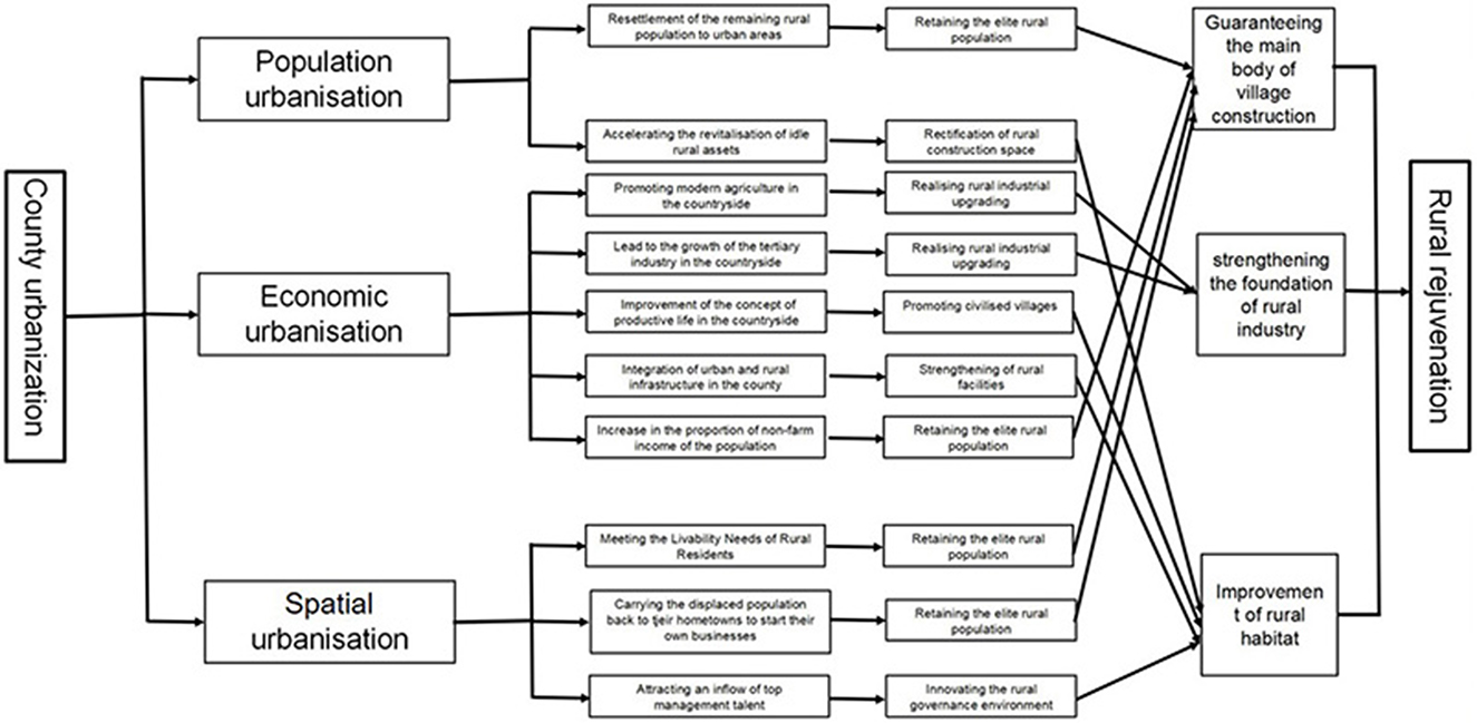
Figure 1. The role path and influence mechanism of urbanization promotion on rural revitalization in China's county areas.
In the whole model of towns in the county acting on the rural areas through urbanization, towns and the rural areas are both distinct but interdependent, and county urbanization plays a role in the rural areas in different dimensions in terms of population, industry and habitat, which can lead the rural areas from a state of decay with “the hollowing out of the main body, the hollowing out of production, the hollowing out of facilities, and the laxity of grassroots organizations” to a state of revitalization with “the development of production, affluent living, ecological livability, civilized township style, and effective governance” (Bibri and Krogstie, 2017; Ekeocha, 2021; Ahmad et al., 2021). Accordingly, in practice, by analyzing the characteristics of the impact of county urbanization on rural revitalization and summarizing the shortcomings of county urbanization under the perspective of rural revitalization, it is a key basis for regulating the development of county urbanization and an inevitable choice for promoting rural revitalization.
2.2 Evaluation indicator system construction
Based on the intrinsic correlation between county urbanization and rural revitalization, it is determined that indicators are selected from three dimensions, namely population urbanization, spatial urbanization and economic urbanization, to measure the level of county urbanization. Considering that at this stage the Chinese government has issued ≪Opinions on Promoting Urbanization with County Towns as Important Carriers≫, and that the construction of county urbanization centered on county towns will strongly drive rural revitalization, this paper especially takes the population size of county town as one of the important indicators of county population urbanization. The core task of China's rural revitalization is to increase farmers' incomes and improve their quality of life through industrial development and improvement of the human habitat, including the facility environment, the ecological environment and the cultural environment, reflecting the fact that the progress of population, industry and the human habitat is an important foundation for rural development, and the impact of county urbanization on rural revitalization is also mainly reflected in these three aspects, so that the selection of evaluation indexes accordingly is in line with the core requirements and the essential connotation of rural revitalization. With reference to the existing literature on urbanization measurement and based on the principles of scientificity, systematicity and accessibility, a total of 14 relevant indicators were selected to constitute its evaluation indicators system, of which county urbanization contains 7 indicators and rural revitalization contains 7 indicators (Table 1).
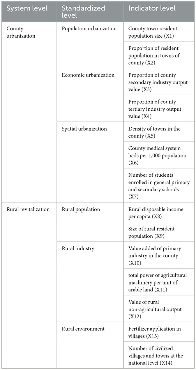
Table 1. Comprehensive evaluation indicator system for county urbanization and rural revitalization development in Northeast China.
3 Study area and research method
3.1 Study area
The selection of Northeast China as an example to analyze the impact effect of county urbanization on rural revitalization in China and its spatio-temporal characteristics is based on two main considerations. First, from the viewpoint of China's practice since the reform and opening up, although a few areas such as the Pearl River Delta and Yangtze River Delta on the eastern coast have achieved transformational development of the rural areas through the urbanization of townships and villages, the development of the rural areas in the vast inland areas is still extremely inadequate (Wang et al., 2017; Liu et al., 2018; Adam et al., 2018). The urbanization and rural development of Northeast China is typical of China's inland: urbanization is mainly promoted in large and medium-sized cities, county urbanization is inherently insufficient, and it generally faces the problems of small size of towns, slow development of non-agricultural industries, low non-agricultural incomes of peasants, weak radiation drive of towns to the rural areas, and the phenomenon of rural population exodus and hollowing out is serious (Sun and Ding, 2016; Hibbard and Frank, 2019; Osman et al., 2016; Penazzi et al., 2019; Liu et al., 2023). Secondly, Northeast China is a relatively independent natural geographic unit and a relatively complete regional economic unit, and the counties within the region are comparable due to the obvious differences in natural conditions, geographic location, economic system, social environment, and historical lineage, which makes it convenient to reveal the internal differences and propose optimized regulatory countermeasures.
Northeast China is divided from north to south with three provinces: Heilongjiang, Jilin and Liaoning, with a total of 36 prefecture-level units and 147 counties (Figure 2). The remaining 143 county-level units were selected for analysis because data were missing for four counties in Heilongjiang Province: Tangwang County, Fenglin County, Daiyishan County, and Nanqiao County. In 2013, when the Chinese government put forward the development strategy of new urbanization, it began to pay formal attention to the issue of the impact of small towns on rural development, so the starting time of the study was set as 2013, and the period of the study was set as 2013–2020 according to the feasibility of obtaining statistical data. The data for the study come from two main sources: first, the vector map of county-level administrative areas in the three provinces of Northeast China, which is derived from China's 1:250,000 basic geographic data provided by the Resource and Environmental Science Data Center of the Chinese Academy of Sciences, and for the phenomenon of administrative division adjustment that existed during the study time period, it was handled by unifying the administrative divisions of the county-level municipalities up to the year 2020. Second, the socio-economic statistics of the counties in the three provinces are mainly derived from the 2013-2020 statistical yearbooks of each province, ≪the China County Economic Statistics Yearbook ≫(county and city volume), ≪the China Rural Statistics Yearbook≫, the socio-economic statistical bulletins issued by the county and city statistical bureaus, and the China Civilization Network. Smoothing was performed with multiple interpolation according to the actual situation, and some data were processed through secondary calculations (per capita and per capita) in order to enhance comparability.
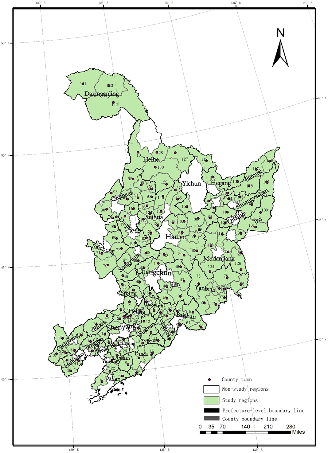
Figure 2. Spatial distribution of counties in Northeast China. 1: Kangping 2: Faku 3: Xinmin 4: Changhai 5: Wafangdian 6: Zhuanghe 7: Tai'an 8: Xiuyan 9: Haicheng 10: Fushun 11: Xinbin 12: Qingyuan 13: Benxi 14: Huanren 15: Kuandian 16: Donggang 17: Fengcheng 18: Heishan 19: Yixian 20: Linghai 21: Beizhen 22: Gaizhou 23: Dashiqiao 24: Fuxin 25: Zhangwu 26: Liaoyang 27: Dengta 28: Panshan 29: Tieling 30: Xifeng 31 : Changtu 32: Jiaobingshan 33: Kaiyuan 34: Chaoyang 35: Jianping 36: Karaqin 37: Beipiao 38: Lingyuan 39: Suizhong 40: Jianchang 41: Xingcheng 42: Nong'an 43: Yushu 44: Dehui 45: Gongzhuling 46: Yongji 47: Jiaohe 48: Huadian 49: Shulan 50: Panshi 51: Lishu 52: Yitong 53: Shuangliao 54: Dongfeng 55: Dongliao 56: Tonghua 57: Huinan 58: Liuhe 59: Meihekou 60: Ji‘an 61: Fusong 62: Jingyu 63 : Changbai 64: Linjiang 65: Qianguoerlus 66: Changling 67: Qian'an 68: Fuyu 69: Zhentai 70: Tongyu 71: Taonan 72: Daan 73: Yanji 74: Tumen 75: Dunhua 76: Hunchun 77: Longjing 78: Helong 79: Wangqing 80: Antu 81: Yilan 82: Fangzheng 83: Bin 84: Bayan 85: Mulan 86: Tonghe 87: Yanshou 88: Shangzhi 89: Wuchang 90: Longjiang 91: Yi‘an 92: Tailai 93: Gannan 94: Fufu 95: Keshan 96: Kedong 97: Baiquan 98: Nehe 99: Jidong 100: Hulin 101: Mishan 102: Luobei 103: Suibin 104: Jixian 105: Youyi 106: Baoqing 107: Raohe 108: Zhaozhou 109: Zhaoyuan 110: Lindian 111: Dulbert 112: Jiayin 113: Tieli 114: Huanan 115: Huachuan 116: Tangyuan 117: Tongjiang 118 : Fujin 119: Fuyuan 120: Boli 121: Linkou 122: Suifenhe 123: Hailin 124: Ning'an 125: Muling 126: Dongning 127: Xunke 128: Sunwu 129: Bei‘an 130: Wudalianchi 131: Nenjiang 132: Wangkui 133: Lanxi 134: Qinggang 135: Qing'an 136: Mingshui 137: Suileng 138: Anda 139: Zhaodong 140: Hailun 141: Mohe 142: Huma 143: Tahe.
3.2 Research method
3.2.1 Evaluation model of county urbanization and rural revitalization
According to the calculation steps of entropy value method, firstly, the method of extreme value standardization is used to unify and standardize 8,008 urbanization development indicators and 8,008 rural development indicators of 143 counties in Northeast China from 2013 to 2020, and on the basis of which the standardization matrix is constructed, from which the entropy value and differentiation coefficients are obtained, and the weights of each indicator are then obtained. Finally, the comprehensive development scores of county urbanization and rural revitalization are calculated for each year.
Where: uij is the standardized indicator value; λij is the weight obtained by the entropy value method; U1 and U2 are the comprehensive evaluation scores of urbanization and rural revitalization respectively.
3.2.2 Spatial association description method
Global spatial auto correlation is an analytical tool to identify whether the spatial distribution of geographic things belongs to agglomeration, dispersion, or stochastic state, and the spatial differentiation characteristics of the degree of county urbanization and rural revitalization in Northeast China are determined by using Moran's I overall, which is calculated as follows:
Where, Wij is the spatial weight of elements i and j; Xi, Xj are the attribute values of X in the corresponding spatial units i and j; is the average value of X; n is the total number of elements. I takes the value of the range [-1,1], if I>0, it means that the spatial distribution of the elements belongs to the agglomeration mode; if I<0, it means that the spatial distribution of the elements belongs to the decentralization mode. The more I converges to 1 or−1, the more obvious the difference of spatial distribution of elements is. Based on the results of Moran's I, the hot spot analysis (Getis-Ord Gi*) in ArcGIS 10.2 is further used to identify the “cold spots” and “hot spots” of the index of county urbanization and rural revitalization of Northeast China, and to screen out the heavy and light agglomerations of county urbanization and rural revitalization.
3.2.3 OLS regression model
OLS is a global regression model that assumes that the data generation process is spatially smooth so that a single coefficient explains the relationship between each explanatory and dependent variable. Based on the theoretical framework of the impact of county urbanization on rural revitalization, this paper takes the development index of rural revitalization as the dependent variable, and seven indicators in total, including the level of development of county town, urbanization of population, spatial urbanization, and economic urbanization, which characterize county urbanization, as the independent variables to analyze the average impact effect of each indicator of county urbanization on rural revitalization in Northeast China. The formula is as follows:
where i represents the region, t represents time, Y refers to the development level of rural revitalization, X1 refers to the size of the county town's resident population, X2 indicates the proportion of the county's urban resident population, X3 represents the proportion of the county's secondary industry output, X4 represents the proportion of the county's tertiary industry output, X5 represents the density of towns in the county, X6 represents the number of medical beds per 1,000 people in the county, X7 represents the number of students enrolled in ordinary primary and secondary schools, and β0, β1, β2, β3, β4, β5, β6, β7 indicates the regression coefficient in the model, which denotes the random perturbation term.
3.2.4 Geographical and temporal weighted regression (GTWR)
While traditional linear regression models only represent the “average” effect of parameters, Geographically Weighted Regression (GWR) can incorporate the spatial characteristics of the data into the model, allowing local parameters to vary with spatial location, and exploring the spatial variability of the influencing factors in different geographic locations and their patterns. The Geographical and Temporal Weighted Regression (GTWR) model introduces a time dimension based on the consideration of spatial heterogeneity, which can effectively deal with temporal non-stationarity, and is calculated as follows (Gelfand et al., 2003; Huang et al., 2009, 2010):
where Yi is the value of the explanatory variable at sample point i (i=1,2,3..., n), n is the number of sample points, and m is the number of explanatory variables; ti is the temporal coordinate of the ith sample point; α0(ui, vi, ti) denotes the spatio-temporal intercept term at sample point i; Xij denotes the value of the jth explanatory variable at sample point i; αj (ui, vi, ti) denotes the regression coefficient of the jth variable at sample point i as a function of spatio-temporal coordinates; ξi denotes the residuals. Due to the introduction of spatio-temporal three-dimensional coordinates into the model, GTWR can improve the model fitting accuracy and provide the analysis of the effect of each explanatory variable on the dependent variable from a spatio-temporal three-dimensional perspective, which has a better explanatory power.
4 Findings
4.1 Spatio-temporal correlation between county urbanization and rural revitalization in Northeast China
4.1.1 Spatial and temporal patterns of county urbanization in Northeast China
From 2013 to 2020, the comprehensive evaluation weights of the subsystems of county urbanization in Northeast China are: spatial urbanization subsystem (0.43) > economic urbanization subsystem (0.27) > population urbanization subsystem (0.17) > county town development subsystem (0.13). It can be seen that the construction of physical space, mainly infrastructure and public service facilities, is the main driving force for the development of county urbanization in Northeast China, while the low level of non-agriculturalization in counties and the insufficient scale of agglomeration in county towns have led to a grim situation of population exodus and impeded the development of county urbanization, and the average level of county urbanization in Northeast China has thus shown a downward trend in the form of low-level fluctuations, from 0.343 in 2013 to 2020 0.322. During the study period, county urbanization in Northeast China shows a stable spatial pattern of “high in the south and low in the north”, with the average level of county urbanization in Liaoning, Jilin, and Heilongjiang provinces are 0.385 > 0.372 > 0.272 in 2013, 0.4 > 0.39 > 0.273 in 2017, and 0.372 > 0.337 > 0.253 in 2020 respectively (Figure 3).
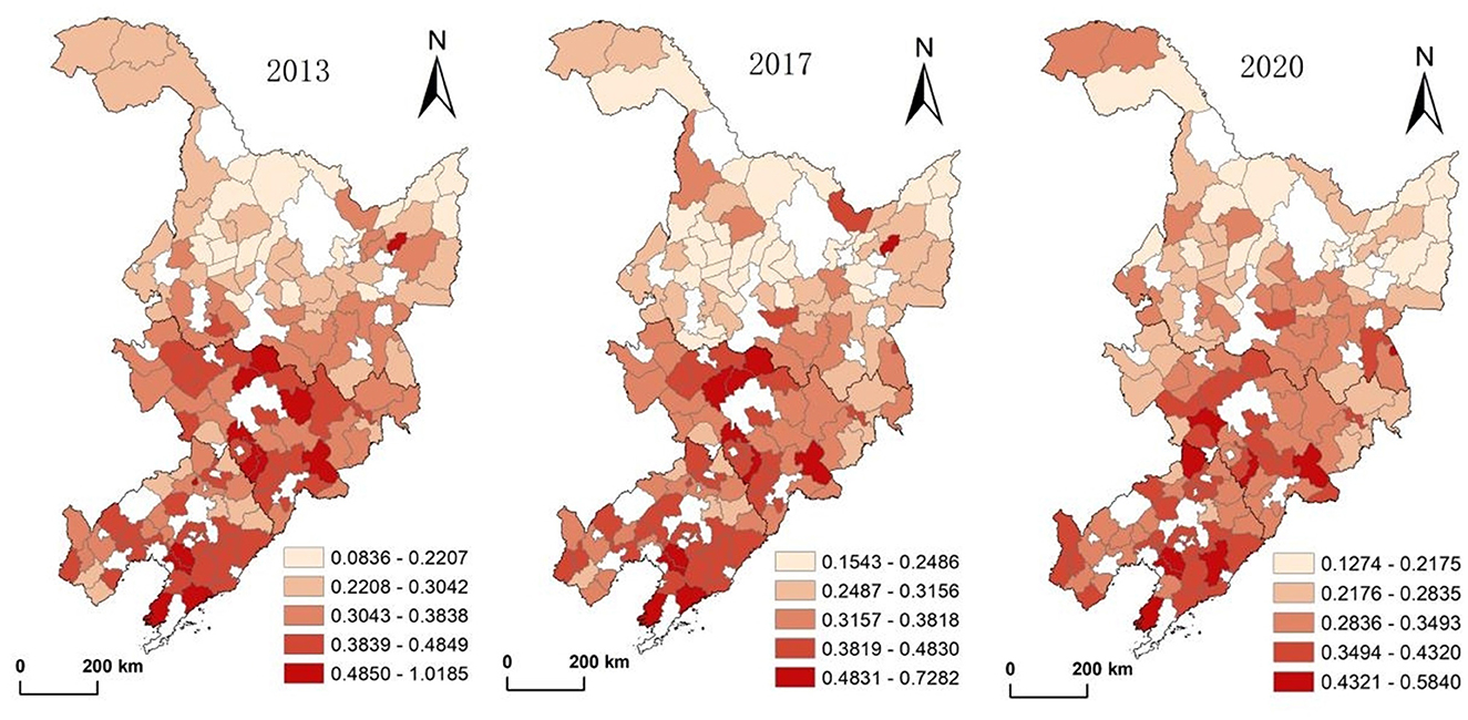
Figure 3. Evolution of spatial patterns of county urbanization in Northeast China.
The global Moran's I values for county urbanization in the Northeast in 2013, 2017, and 2020 are positive and significant at the 5% level, with significant positive spatial correlations and spatial aggregation patterns. The results of the cold and hot spot analysis (Figure 4) show that the hot spot of high level of county urbanization in Northeast China has always been in the central part of Jilin and the mid-southern part of Liaoning Province, while the cold spot of low level of urbanization has always been located in the northern part of Heilongjiang Province, and the hot spot has been continuously concentrating to the south, while the cold spot area has been gradually concentrating to the north, which coincides with the spatial pattern of “high in the south, and low in the north” that has always been presented by the county urbanization of Northeast China during the period of the study.
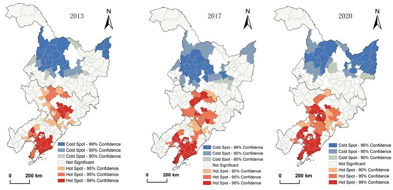
Figure 4. Characteristics of spatial agglomeration of county urbanization in Northeast China.
4.1.2 Spatial and temporal patterns of rural revitalization levels in Northeast China
From 2013–2020, the average level of rural revitalization in counties of Northeast China has been low but has increased slightly, from 0.316 to 0.345. The comprehensive evaluation weights of the subsystems of rural revitalization in Northeast China are: rural industry subsystem (0.43) > rural population subsystem (0.32) > rural environment subsystem (0.24), which indicates that agricultural modernization in Northeast China has been effective in recent years, but the outflow of the rural population and the poor rural living environment are the crux of rural development. From a spatial perspective, rural revitalization in Northeast China in 2013, 2017, and 2020 shows a spatial pattern of “center-periphery”, with the twin center of the Harbin-Changchun and mid-southern Liaoning urban agglomerations, being significantly higher than that of the peripheral regions in the northern, eastern and western parts of Northeast China. Between 2013 and 2020, the level of rural development in the central area declined significantly, and the spatial characteristics of the “center-periphery” weakened (Figure 5).
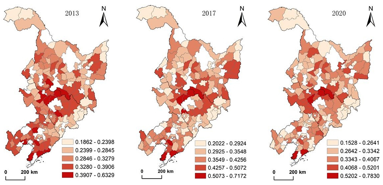
Figure 5. Evolution of spatial pattern of rural revitalization in Northeast China.
The global Moran's I values for rural revitalization in Northeast China in 2013, 2017, and 2020 are positive and significant at the 5% level, with significant positive spatial correlations and spatial aggregation patterns. The results of the cold hotspot analysis (Figure 6) show that the hotspot areas of high-level agglomeration for rural revitalization in Northeast China have always been in the central areas of the Harbin-Changchun and mid-southern Liaoning urban agglomerations, but the area of the hotspot areas in the south has decreased; the coldspot areas of low-level agglomeration have always been located in the areas outside of the city clusters, with the northern part of Heilongjiang and the eastern part of Jilin being the obvious low-value agglomerations in 2013, and by 2020 the coldspot areas of the northern part of Heilongjiang have disappeared, and the eastern part of Jilin has remained as a coldspot area, whereas new coldspot areas have appeared in the western part of Liaoning. This change in the distribution of hot and cold spots is consistent with the evolution of the rural revitalization pattern of “center-periphery” in Northeast China.
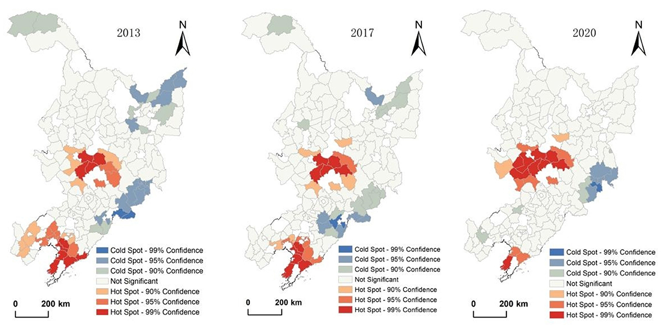
Figure 6. Characteristics of spatial agglomeration for rural revitalization in Northeast China.
4.1.3 Characteristics of the association between county urbanization and rural revitalization in Northeast China
In order to preliminarily reveal the impact of county urbanization on rural revitalization in Northeast China, the spatial development pattern of county urbanization and rural revitalization in Northeast China is superimposed and compared. The characteristics of changes in the mean values of each indicator of rural revitalization in the five types of county urbanization with low (A), lower (B), medium (C), higher (D) and high (E) levels are observed, and the results are shown in Table 2.
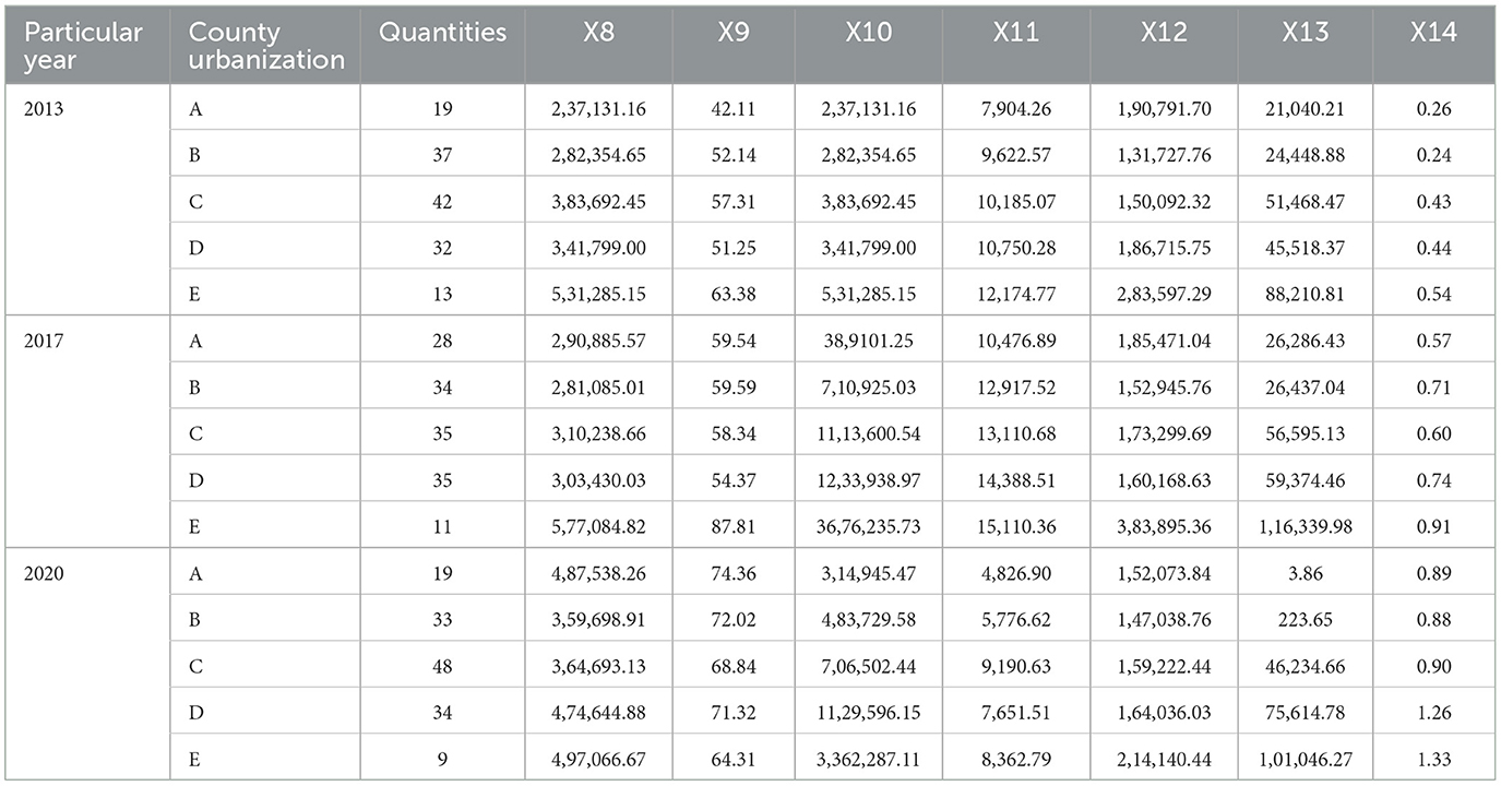
Table 2. Spatial associations between county urbanization types and the mean values of various indicators of rural revitalization in Northeast China.
The results of statistical descriptive analysis show that in 2013 and 2017, the level of rural revitalization in counties with higher levels of urbanization in Northeast China was also higher, and the average of all rural indicators in counties with medium or higher levels of urbanization were higher than those in counties with lower levels of urbanization or less, especially in counties with high levels of urbanization whose indicators of rural development were significantly ahead of those in other counties; In 2020, except for two rural revitalization indicators, the value added of the primary industry in counties (X10) and the total power of agricultural machinery per unit of arable land in villages (X11), which also show high values in counties with a low level of urbanization, the average values of the remaining rural revitalization indicators increase with the higher level of development of urbanization in counties. It can be seen that the spatial distribution of various indicators of rural revitalization and the level of county urbanization in Northeast China are basically kept in sync, and there is indeed a certain role of county urbanization in the development of rural revitalization.
4.2 The overall impact effect of county urbanization on rural revitalization in Northeast China
Use OLS regression model to deeply analyze the impact effect of county urbanization on rural revitalization in Northeast China, and verify the impact effect of each indicator of county urbanization on rural revitalization (Table 3). From 2013 to 2020, in the county urbanization development indicators, X1 and X5 did not pass the significance test of OLS, implying that county urbanization development centered on towns in Northeast China has a long way to go; Although X2, X3, X4, X6, and X7 pass the significance test of OLS, the average regression coefficient of these five indicators on rural revitalization is 0.142, indicating that the role of county urbanization on rural revitalization in Northeast China is weak, and that there is still a great deal of potential to be realized. The specific mechanism of action of each indicator is described below:
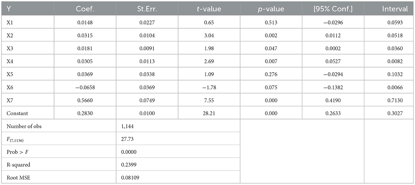
Table 3. OLS model regression results.
X2 is the proportion of the sum of the population of county town and the population of other designated towns to the total population of the county, reflecting the size of the urban population in county. The size of towns in county at all levels in Northeast China is generally small, with an average population of 50,600 in county towns and 0.57 million in designated towns; towns in county have poor agglomeration and diffusion capacity, low ability to attract population transfer within the county, and insufficient impetus to the rural areas; this indicator has the weakest impact on rural revitalization in Northeast China, with a regression coefficient of only 0.015.
X3 represents the level of secondary industry development of counties in Northeast China, and the regression coefficient for rural revitalization is 0.018, with the same weak influence. On the one hand, due to the low population density in rural areas of Northeast China, the contradiction between people and land is not prominent, the market size is small, and the pressure and growth environment for the development of rural enterprises is inherently insufficient; On the other hand, there has been a dual structure between the central cities and peripheral counties in Northeast China for a long time, the central city's heavy industry had a limited effect on the peripheral counties, counties are mostly based on the development of agriculture, and the promotion of industrialization is slow. As a result, the proportion of surplus rural labor force transferred locally and the non-agricultural income of farmers in the counties are low, and there is insufficient impetus for the development of rural revitalization.
The regression coefficient of the impact of the level of county tertiary industry development on rural revitalization in Northeast China represented by X4 is 0.031, which is slightly higher than that of X3. Although towns in the county at all levels in Northeast China have long assumed the function of organizing the economic and social development of rural areas, and have radiated the peripheral rural hinterland in terms of commerce and transportation, most towns and villages in counties have not formed industrial chain linkages in the tertiary industry, and this indicator has a limited role in driving the development of rural areas.
The regression coefficient of X6 on the development level of rural revitalization is −0.066, which is an obstacle to rural revitalization. Northeast China, like China as a whole, suffers from the problem of urban and rural basic medical service facilities being “stronger at the top and weaker at the bottom”, and there is an obvious gap between the basic medical facilities in towns and those in central cities, so that the needs of the population of rural areas for access to medical care in the immediate vicinity cannot be effectively guaranteed, thus restricting the agglomeration of the population of the county and the development of rural revitalization.
X7 has the strongest effect on the level of development of rural revitalization, with a regression coefficient of 0.566. Since 2017, as China's overall urban and rural education resources have been adjusted to equalize, education facilities in counties in Northeast China have been gradually improved. Towns in the county have become an important educational choice for rural families due to smaller cultural differences between them and the rural areas as well as lower education costs, and the migration of rural school-age populations and family escorts to nearby towns in Northeast China has become the main mode of county urbanization in the context of weak industrial pull.
4.3 Spatial differentiation of the impact effect of county urbanization on rural revitalization in Northeast China
Although the OLS regression model can identify the main influencing factors of county urbanization on rural revitalization in Northeast China, it is difficult to capture the spatial and temporal characteristics of the role of each factor on rural revitalization, which is of little significance in guiding the choice of differentiated county urbanization development paths. Therefore, the GTWR model was used to develop the analysis of spatio-temporal heterogeneity of the main influence factors of county urbanization on rural revitalization in Northeast China, as shown in Table 4, the analytical R2 of the GTWR model and the corrected R2 are both higher than 0.95, and the goodness of fit indicates that the model has a better explanatory effect.

Table 4. Parameters related to GTWR.
Spatio-temporal divergence in the impact of the proportion of resident population in towns of the county (Figure 7). From 2013 to 2020, the proportion of urban resident population in the counties of the Northeast China always be at a low level below 0.15, with a spatial shift from “high in the north and low in the south” to “high in the south and low in the north”. In 2013 and 2017, the indicator had a negative effect on rural revitalization in most counties in Northeast China, and only in 2020 did it show a more pronounced positive boost to rural revitalization in the southern counties. Because of the inherent lack of development of small towns in the counties of Northeast China, the strength of the prefecture central city to which each county belongs has a significant impact on the changes in this indicator and its impact effects. Cities in the northern part of Northeast China lack resources and industrial support are far away from mega-cities or city clusters, and are weak in driving the peripheral counties, with the proportion of urban resident population in the counties declining, and the impact on rural revitalization diminishing; while the southern Northeast China, the mid-southern Liaoning urban agglomeration and the central part of Jilin are densely populated with large and medium-sized cities, and after the strategy of “integration of urban and rural areas” was put forward in 2017, the population of the counties in the southern part of Northeast China increased with the driving force of the central city, and the push for rural revitalization was also strengthened accordingly.
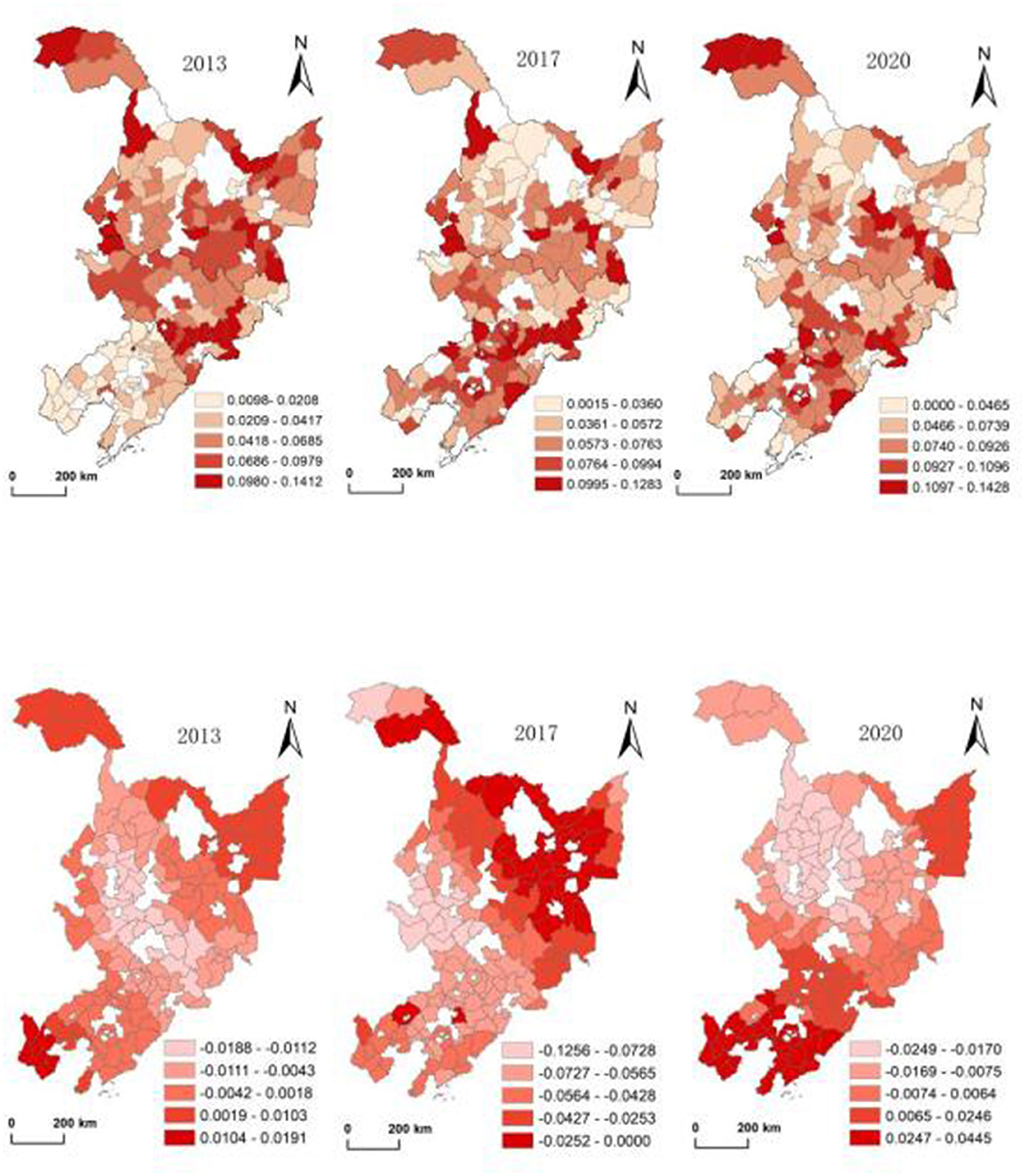
Figure 7. Spatio-temporal distribution of the proportion of urban resident population in counties in Northeast China and spatio-temporal differentiation of its impact on rural revitalization.
Spatio-temporal divergence in the effect of the proportion of secondary industry output in counties (Figure 8). The industrial development of counties in Northeast China is dominated by the agricultural products processing industry, and a few counties around the big cities can undertake a certain amount of pharmaceuticals, petroleum, auto parts and other specialty processing industries. In 2013, except for the proportion of secondary industry in the counties along the border zone in northern Heilongjiang, which was significantly lower than the regional average, the agricultural product processing industry in the rest of the counties developed accordingly during the first phase of the strategy of revitalizing Northeast China, and the counties with a strong impact on rural revitalization by this indicator were located in the Harbin-Daqing-Qiqihar industrial corridor, which was the key focus of Heilongjiang Province at that time. In 2017, county industries in Northeast China began to contract due to the impact of the region-wide economic decline, counties in the Harbin-Daqing-Qiqihar region with the sluggish dairy industry has weakened the drive to rural development, and specialty agricultural product processing in the Daxing'anling, Sanjiang Plain, and the West Liaoning Corridor counties retained some influence on rural development. In 2020, with the spatial development of large cities in Northeast China from agglomeration to diffusion, industrial strength of counties in central Jilin Province and mid-southern Liaoning Province is the strongest, and its ability to drive the development of the periphery rural areas is relatively obvious; In Harbin city, where is in the northern part of Northeast China, industrial bearer space is relatively sufficient due to the withdrawal of the counties into the district, lead to the industrial radiation to the periphery counties is weak, and rural areas are also less driven by county secondary industry.
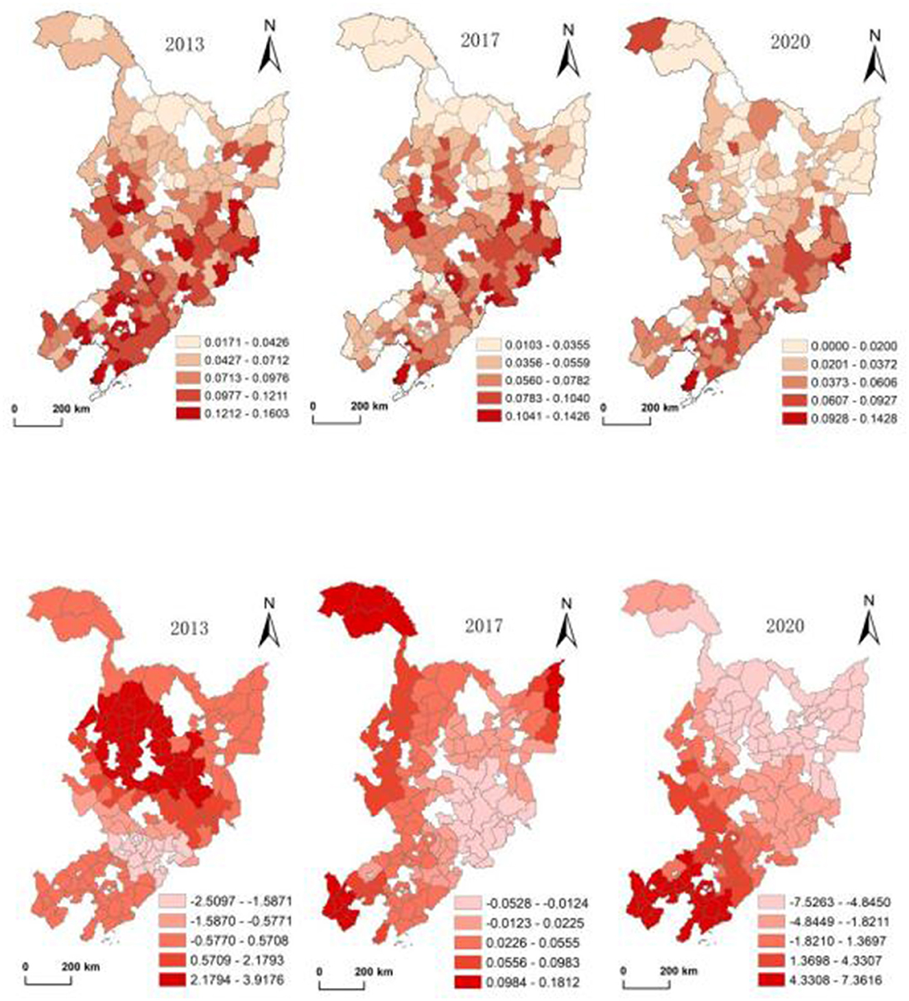
Figure 8. Spatio-temporal distribution of the proportion of secondary industry output value in counties in Northeast China and its spatio-temporal differentiation on the impact of rural revitalization.
Spatio-temporal divergence in the impact of the proportion of county tertiary sector output (Figure 9). The tertiary industry in counties in Northeast China is mainly commercial services and tourism. From 2013 to 2020, counties with higher values of this indicator are mainly distributed in the Harbin-Changchun urban agglomeration and mid-southern Liaoning urban agglomeration, and counties with a stronger impact on rural revitalization are also gradually clustered from the northern part of the Northeast China to the two major urban agglomerations. The reason for this is that the strength of the prefecture-level centers in the northern part of Northeast China is weak, the spatial deprivation to the county is not strong, and the centrality function of towns in the county has been brought into play to a certain extent; while the towns in the southern part of Northeast China, despite having a certain degree of service capacity, have been inhibited by the prefecture-level centers in terms of their radiation-driven role in the rural areas. In recent years, the two major urban agglomerations, as pioneering spaces for “urban-rural integration” in Northeast China, have promoted the coordination and interaction of towns in the counties and prefecture centers within the urban agglomerations, and the impact of the service capacity of the towns in counties on the development of the rural areas has been gradually strengthened.
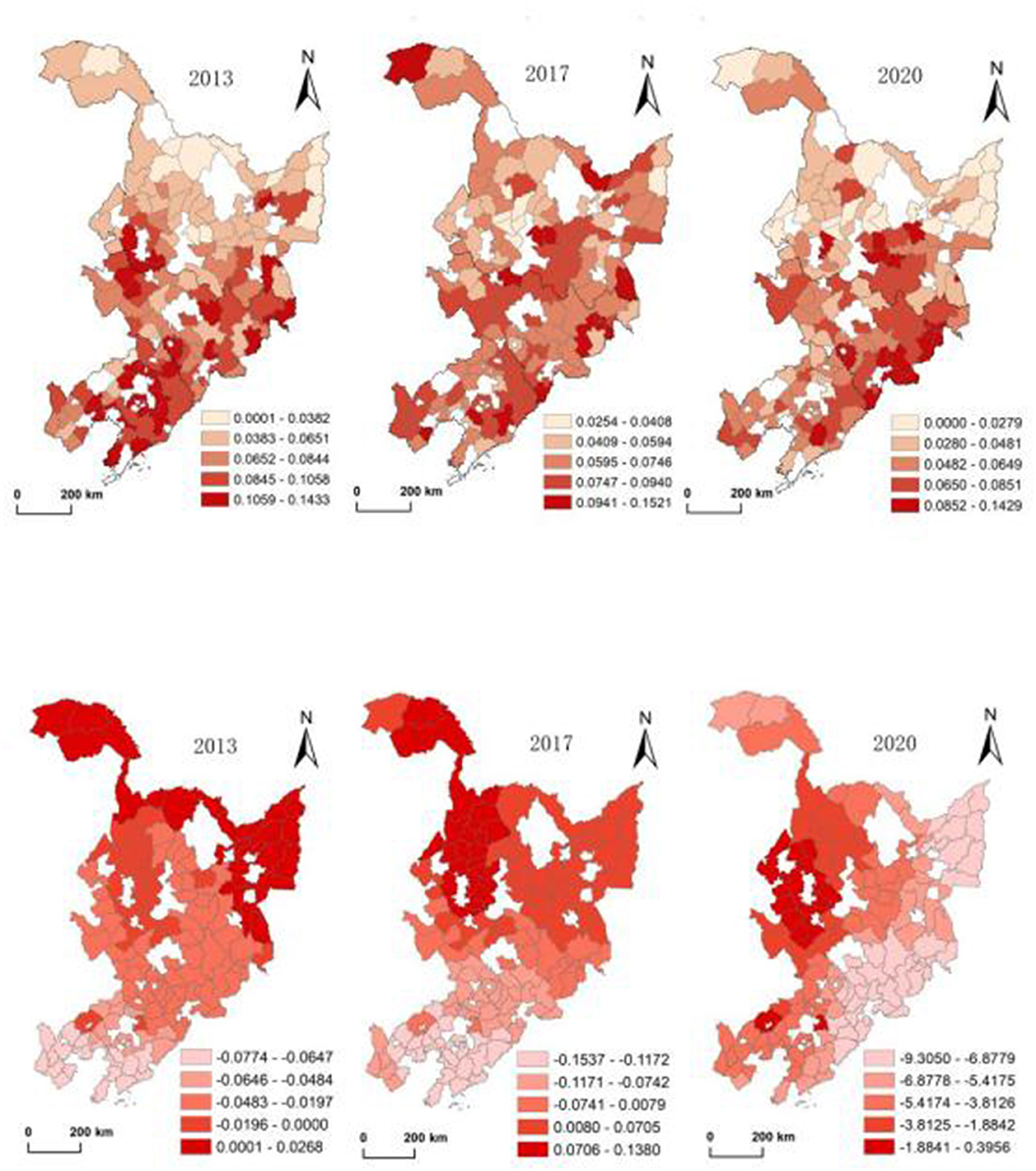
Figure 9. Spatial distribution of the proportion of tertiary industry output value in Northeastern China counties and spatial-temporal differences of its impact on rural revitalization.
Spatial and temporal variability in the impact of the number of medical system beds per 1,000 population in a county (Figure 10). Between 2013 and 2020, county healthcare in Northeast China showed a low level of slow growth, but the spatial distribution was always relatively balanced. During the study period, the impact of medical level on rural revitalization was negative in most counties in Northeast China, and the spatial pattern changed from “high in the south and low in the north” to “high in the north and low in the south”. The reason is that the southern counties in Northeast China are generally closer to the central city, and the medical functions of towns in the county are seriously diverted by the central city; while the density of towns in the northern part of Heilongjiang Province is lower, and most of the towns are farther away from the central city, the medical functions of the counties have been brought into play to a certain extent, and the impetus for the rural revitalization is relatively obvious.
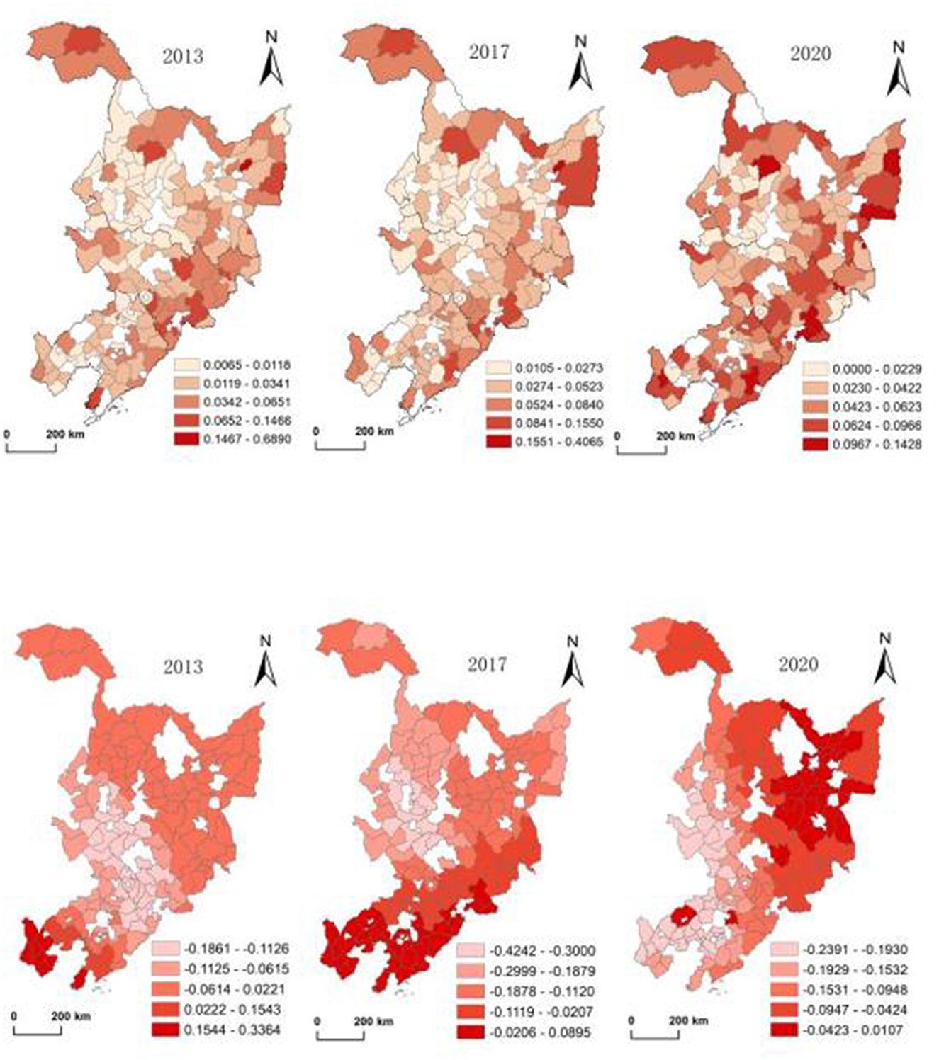
Figure 10. Spatial and temporal distribution of medical system beds per 1,000 population in counties in Northeast China and spatial-temporal variations of its impact on rural revitalization.
Spatial and temporal variability in the impact of the number of students enrolled in general elementary and secondary schools (Figure 11). From 2013 to 2020, the education scale of counties in Northeast China has the strongest impact on rural revitalization, and spatially it always maintains the basic characteristics of Harbin-Changchun and mid-southern Liaoning urban agglomerations as the core, which presenting a “center-periphery” pattern. The impact of this indicator on rural revitalization in Northeast China has gradually shifted from “high in the north and low in the south” to “balanced in the north and south”, which is clearly related to the influence of prefecture-level central cities; prefecture-level cities in the southern part of the Northeast China have shifted their role from deprivation to driving of the peripheral counties, which has led to the increasing impact of county educational resources on rural revitalization. And in the northern part of Northeast China, the weakness of the prefecture-level cities has given the counties some room for development, as a result, the effect of this indicator is always obvious.
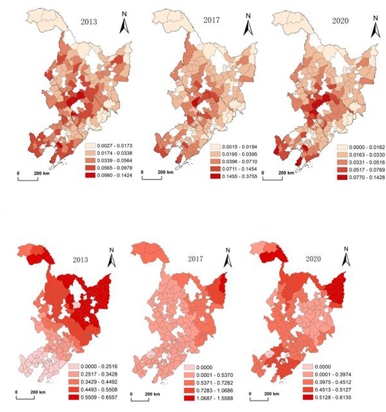
Figure 11. Spatial distribution of the number of students enrolled in general primary and secondary schools in northeastern counties of China and spatial-temporal variations of its impact on rural revitalization.
5 Conclusion and discussion
5.1 Conclusion
(1) From 2013 to 2020, the urbanization of counties in Northeast China showed a low level of fluctuation and a downward trend, with its average value decreasing from 0.343 to 0.322, and spatially it has been showing a relatively stable pattern of “high in the south and low in the north”, but the gap between the north and the south has been narrowing; Rural revitalization in Northeast China shows a low and slow upward trend, with the average value rising from 0.316 to 0.345, and a spatial pattern of “center-periphery”, with Harbin-Changchun and mid-southern Liaoning urban agglomerations being the high-value areas for rural development. A statistical descriptive analysis of county urbanization and rural revitalization in Northeast China reveals that the two have maintained synchronous development in most counties, indicating that county urbanization does play a role in rural revitalization.
(2) The results of OLS regression analysis show that the impact of county urbanization on rural revitalization in Northeast China is weak, the population size of county town (X1) and the density of towns in the county (X5) do not pass the test of significance, and the low agglomeration capacity of county towns and the small number of designated towns are the key constraints on the development of county urbanization and its rural revitalization effect. Five indicators, including the proportion of county urban resident population (X2), the proportion of county secondary industry output value (X3), the proportion of county tertiary industry output value (X4), the number of medical system beds per 1,000 people in the county (X6), and the number of students enrolled in general primary and secondary schools (X7), are the main influencing factors of the role of county urbanization on rural revitalization in Northeast China, but the average regression coefficient of the five indicators on rural revitalization is 0.142, the driving effect of county urbanization on rural revitalization in Northeast China needs to be improved urgently.
(3) There is spatial differentiation in the intensity of the role of the main influences of county urbanization on rural revitalization in Northeast China. The impact of the two indicators, namely the proportion of county urban resident population and the proportion of county secondary industry output value, shows a clear pattern or development trend of “high in the south and low in the north”; the high impact intensity of the county's share of tertiary sector output is gradually clustered toward the two major urban agglomerations; the influence pattern of the level of medical care in the county has changed from “high in the south and low in the north” to “high in the north and low in the south”; the pattern of influence on the level of education in the county has gradually evolved from a pattern of “low in the south and high in the north” to “balanced in the north and south”. The spatial and temporal differences in the intensity of the role of main indicators of county urbanization are clearly associated with the strength of the radiation capacity of prefecture-level central cities.
5.2 Discussion
(1) Attaching importance to the role and status of small towns in the process of urbanization is an inevitable choice to promote the modernization and transformation of villages and to narrow the gap between urban and rural areas, and there is a serious lack of research on small towns and rural development, despite the fact that the majority of developing countries are facing varying degrees of rural development dilemmas. China's county urbanization is essentially an urbanization pattern dominated by small towns. Taking the 143 counties in Northeast China as an example, research on the impact effect of county urbanization on rural revitalization will not only provide theoretical research results on the interrelationships between small towns and villages in developing countries, but also provide practical guidance for the healthy development of urbanization in China's counties and the smooth promotion of rural revitalization.
(2) According to the temporal and spatial characteristics of the impact effect of county urbanization on rural revitalization in Northeast China, it is necessary to accelerate the construction of county urbanization in many ways in order to give full play to its positive effect on rural revitalization. First of all, to improve the function of towns in Northeast China, we should fully consider the multi-scale nested characteristics of the urban-rural system, in particular, we should consider the functional coordination between prefecture-level cities and towns in the county under the “city administered county” system. For example, for large-scale prefecture-level cities, the focus of the administrative management on the peripheral counties is to strengthen the radiation drive; for small-scale prefecture-level cities, the focus of the administrative management over the peripheral counties is to weaken the deprivation. Secondly, the focus is on accelerating the construction of the carrier functions of various types of towns in the counties of the Northeast China, and strengthening the service capacity in such areas as medical care and commerce, especially in the county towns, which should attract the rural population to gather through the strengthening of their functions. Thirdly, the county industrial strength enhancement is the core to drive rural revitalization, located in the two major urban agglomerations, the county should be with the central city to build a metropolitan area, cultivate towns in the county to become the core of the development of modern industry space; located in the peripheral areas, the county can rely on the county industrial zone and key townships to construct large-scale processing zones of agricultural products. The counties that have the conditions are encouraged to cooperate with provincial and national development zones to build county industrial parks in order to realize the leapfrog development of county industry, and the township centralized industrial zones are organized in the way of spatial agglomeration of enterprises and industrial clusters to form new industrial zones, and the main features of the new industrial zones in the townships should be based on the grain-producing to promote the internal transfer of the county's rural labor force. Fourthly, counties in Northeast China should take rural tourism, leisure agriculture, and rural e-commerce as entry points, construct urban and rural service industry chains reasonably, and bring the driving force of the tertiary industry on the rural areas into play effectively.
(3) There are some shortcomings in the research of this paper. The GTWR model is used to analyze the driving force of the impact of county urbanization on rural revitalization in Northeast China, but the application of this method requires in-depth research on the determination of the two-dimensional coordinates of the research unit, the setting of the parameter ratios of the time and spatial dimensions, the optimization of the model bandwidth, and the selection of the time-step unit. Only the effect of each indicator of county urbanization on the rural system as a whole was analyzed, without going deeper into the level of each indicator of the rural system. In addition, limited to the difficulty of data acquisition and processing, Northeast China was chosen as the case area to refract the characteristics of county urbanization and rural revitalization in the whole country, and it is necessary to expand the study area to the whole country in the follow-up study.
Data availability statement
The data analyzed in this study is subject to the following licenses/restrictions: Smoothing was performed with multiple interpolation according to the actual situation, and some data were processed through secondary calculations (per capita and per capita) in order to enhance comparability. Requests to access these datasets should be directed to MTE1MjE5NjI2NEBxcS5jb20=.
Author contributions
JH: Investigation, Data curation, Writing – review & editing, Writing – original draft, Validation, Supervision. LW: Writing – review & editing, Writing – original draft, Data curation, Methodology. HK: Formal analysis, Methodology, Data curation, Investigation, Writing – review & editing. YW: Project administration, Methodology, Formal analysis, Supervision, Writing – review & editing. ZZ: Validation, Project administration, Investigation, Writing – review & editing. XC: Supervision, Project administration, Writing – review & editing, Methodology.
Funding
The author(s) declare that financial support was received for the research and/or publication of this article. 1. Postgraduate Academic Innovation Program of Harbin Normal University, No. HSDSSCX2021-21; 2. Natural Science Foundation of Heilongjiang Province, No. PL2024D009; 3. “Outstanding Young Teacher Basic Research Support Program” of Heilongjiang Province, No. YQJH2024104.
Conflict of interest
The authors declare that the research was conducted in the absence of any commercial or financial relationships that could be construed as a potential conflict of interest.
Generative AI statement
The author(s) declare that no Gen AI was used in the creation of this manuscript.
Publisher's note
All claims expressed in this article are solely those of the authors and do not necessarily represent those of their affiliated organizations, or those of the publisher, the editors and the reviewers. Any product that may be evaluated in this article, or claim that may be made by its manufacturer, is not guaranteed or endorsed by the publisher.
References
Adam, C., Bevan, D., and Gollin, D. (2018). Rural-urban linkages, public investment and transport costs: the case of Tanzania. World Dev. 109, 497–510. doi: 10.1016/j.worlddev.2016.08.013
Ahmad, M., Jiang, P., Murshed, M., Shehzad, K., Akram, R., Cui, L., et al. (2021). Modelling the dynamic linkages between eco-innovation, urbanization, economic growth and ecological footprints for G7 countries: does financial globalization matter?. Sustain. Cities Soc. 70:102881. doi: 10.1016/j.scs.2021.102881
Bibri, S. E., and Krogstie, J. (2017). Smart sustainable cities of the future: an extensive interdisciplinary literature review. Sustain. Cities Soc. 31, 183–212. doi: 10.1016/j.scs.2017.02.016
Cao, Z., Liu, Y., Li, Y., and Wang, Y. (2020). Spatial patterns of specialized villages and towns in China and their influencing factors. J. Geogr. 75, 1647–1666. doi: 10.11821/dlxb202008007
Carlucci, M., Ferrara, C., Rontos, K., Ilaria, Z., and Luca, S. (2020). The long breadth of cities: revisiting worldwide urbanization patterns,1950–2030. Appl. Econ. 52, 4162–4174. doi: 10.1080/00036846.2020.1731410
Chen, C., Gao, J., and Chen, J. (2022). Analysis of the behavioral logics of local actors enrolled in the restructuring of rural China: a case study of Haoqiao Village in Northern Jiangsu. J. Rural Stud. 93, 223–233. doi: 10.1016/j.jrurstud.2019.01.021
Clifford, R. J. (1993). Strategic planning to sustainable rural development. Landsc. Urban Plann. 27, 253–258. doi: 10.1016/0169-2046?93?90058-L
Cui, H., Xu, G., and Yu, H. (2023). Mechanism and path optimization of rural reconstruction process in the context of territorial spatial governance—Taking Guizhou Province as an example. Hum. Geogr. 38, 79–91. doi: 10.13959/j.issn.1003-2398.2023.03.009
Dadi, D., Azadi, H., Senbeta, F., Abebe, K., Taheri, F., and Stellmacher, T. (2016). Urban sprawl and its impacts on land use change in Central Ethiopia. Urban For. Urban Greening 16, 132–141. doi: 10.1016/j.ufug.2016.02.005
Daniels, T. L. (1989). Small town economic development: growth or survival? J. Plann. Literature 4, 413–429. doi: 10.1177/088541228900400404
Ekeocha, D. O. (2021). Urbanization, inequality, economic development and ecological footprint: searching for turning points and regional homogeneity in Africa. J. Clean. Prod. 291:125244. doi: 10.1016/j.jclepro.2020.125244
Fang, C., and Zhao, W. (2023). New urbanization and integrated urban-rural development for Chinese-style modernization. Econ. Geogr. 43, 10–16. doi: 10.15957/j.cnki.jjdl.2023.01.002
Feng, W., Liu, Y., and Qu, L. (2019). Effect of land-centered urbanization on rural development: a regional analysis in China. Land Use Policy 87:104072. doi: 10.1016/j.landusepol.2019.104072
Gao, F., and Zhang, T. (2023). Comprehensively promoting rural revitalization: an inquiry based on the framework of urban-rural continuum with Chinese characteristics. Economist 108–117. doi: 10.16158/j.cnki.51-1312/f.2023.07.008
Gelfand, A. E., Kim, H. J., Sirmans, C. F., and Banerjee, S. (2003). Spatial modeling with spatially varying coefficient processes. J. Am. Stat. Assoc. 98. doi: 10.1198/016214503000170
Gu, C. (2019). Urbanization: processes and driving forces. Sci. China Earth Sci. 62, 1351–1360. doi: 10.1007/s11430-018-9359-y
Hibbard, M., and Frank, K. I. (2019). Notes for a substantive theory of rural planning: evidence from the US experience. Plann. Theory Pract. 20, 339–357. doi: 10.1080/14649357.2019.1627572
Hu, B., and Zhu, Y. (2021). Cultivation of “middle farmers” in the field of rural revitalization strategy: dilemmas and coping strategies. Economist 2021, 110–118. doi: 10.16158/j.cnki.51-1312/f.2021.11.013
Huang, B., Wu, B., and Barry, M. (2010). Geograpphically and temporally weighted regression for modeling spatio-temporal variation in house prices. Int. J. Geogr. Inf. Sci. 24, 383–401. doi: 10.1080/13658810802672469
Huang, B., Zhang, L., and Wu, B. (2009). Spatiotemporal analysis of rural-urban land conversions. Int. J. Geogr. Inf. Sci. 23, 379–398. doi: 10.1080/13658810802119685
Hvenegaard, G. T., Hallstrom, L. K., and Brand, K. L. P. (2019). Implementation dynamics for sustainability planning in rural Canada. J. Rural Commun. Dev. 14, 54–76. doi: 10.7939/r3-8k1c-c933
Lešková A. and Vaishar, A. (2019). Recent population development of very small municipalities in the Czech Republic. Quaestiones Geographicae 38, 63–76. doi: 10.2478/quageo-2019-0034
Liu, H., Zhang, L., Wang, W., Zhang, Y., Wang, Z., Tang, F., et al. (2023). Spatial pattern of county urbanization and influencing factors in China's interprovincial border areas. J. Geogr. 78, 1408–1426. doi: 10.11821/dlxb202306006
Liu, S., Wang, X., and Qi, W. (2019). Spatial and temporal variation in the development of “townization” of urban population in China. Geogr. Res. 38, 85–101. doi: 10.11821/dlyj020180497
Liu, S., and Xue, L. (2021). The spatio-temporal heterogeneity of county-level economic development and primary drivers across the loess plateau, China. J. Geogr. Sci. 31, 423–436. doi: 10.1007/s11442-021-1851-y
Liu, Y. (2018). Urban-rural integration and rural revitalization in China's new era. J. Geogr. 73, 637–650. doi: 10.11821/dlxb201804004
Liu, Y. (2021). Urban-Rural Transformation Geography. Singapore: Springer Nature. doi: 10.1007/978-981-16-4835-9
Liu, Y., Li, J., and Yang, Y. (2018). Strategic adjustment of land use policy under the economic transformation. Land Use Policy 74, 5–14. doi: 10.1016/j.landusepol.2017.07.005
Liu, Y., Yang, R, and Lin, Y. C. (2022). Evolution and optimization path of urbanization pattern in Chinese counties. J. Geogr. 77, 2937–2953. doi: 10.11821/dlxb202212001
Osman, T., Divigalpitiya, P., and Arima, T. (2016). Driving factors of urban sprawl in Giza Govern orate of Greater Cairo Metropolitan Region using AHP method. Land Use Policy 58, 21–31. doi: 10.1016/j.landusepol.2016.07.013
Penazzi, S., Accorsi, R., and Manzini, R. (2019). Planning low carbon urban-rural ecosystems: an integrated transport land-use model. J. Clean. Prod. 96–111. doi: 10.1016/j.jclepro.2019.06.252
Qu, S., Ma, J., Li, Q., and Hu, S. (2023). Evolutionary patterns and driving mechanisms of urbanization quality in counties in the middle reaches of the Yangtze River. Econ. Geogr. 43, 3–102. doi: 10.15957/j.cnki.jjdl.2023.02.010
Robert, W., O'Donnell, T., and Mark Stafford, S. (2023). Enabling urban systems transformations: co-developing national and local strategies. Urban Transform. 5, 1–31. doi: 10.1186/s42854-023-00049-9
Shahraki, H. (2022). Three-dimensional paradigm of rural prosperity: a feast of rural embodiment, post-neoliberalism, and sustainability. World 3, 146–161. doi: 10.3390/world3010008
Shen, J., and Lin, L. (2017). State-sponsored and spontaneous urbanization in Fujian province of China, 1982–2010. Cities 60, 420–427. doi: 10.1016/j.cities.2016.05.021
Shen, Q., Li, C., Hu, S., and Tong, Y. (2021). Measuring the quality of urbanization and characterizing its spatio-temporal pattern in Northeast China. Geography. Science 41, 2002–2010. doi: 10.13249/j.cnki.sgs.2021.11.013
Song, Z., and Zhu, Q. (2020). Spatio- temporal pattern and driving forces of urbanization in China's border areas. J. Geogr. Sci. 30, 775–793. doi: 10.1007/s11442-020-1755-2
Su, H. (2021). The foundation, trend and promotion of urbanization in China's counties. Economist 2021, 110–119. doi: 10.16158/j.cnki.51-1312/f.2021.05.013
Sun, B., and Ding, S. (2016). Do large cities contribute to economic growth of small cities? Evidence from Yangtze River Delta in China. Geogr. Res. 35:9. doi: 10.11821/dlyj201609002
Suvi, H. (2019). Revisiting agricultural modernisation: interconnected farming practices driving rural development at the farm level. J. Rural Stud. 71, 36–45. doi: 10.1016/j.jrurstud.2019.09.004
Tang, M., and Xu, H. (2023). Cultural integration and rural tourism development: a scoping literature review. Tour. Hosp. 4, 75–90. doi: 10.3390/tourhosp4010006
Tselios, V. (2014). Urbanization and socioeconomic status in the European regions: the role of population ageing and capital city regions. Eur. Plann. Stud. 22, 1879–1901. doi: 10.1080/09654313.2013.812063
Vardopoulos, I. (2023). Adaptive reuse for sustainable development and land use: a multivariate linear regression analysis estimating key determinants of public perceptions. Heritage 6, 809–828. doi: 10.3390/heritage6020045
Wang, Y., Sun, P., Li, C., and Song, Y. (2017). Urban-rural co-construction of new districts: a new path of urban-rural spatial integration in metropolitan areas and its mechanism analysis: taking Changchun Changde New District as an example. Econ. Geogr. 37, 53–60. doi: 10.15957/j.cnki.jjdl.2017.02.008
Wei, C., Wu, Z., Li, R., Xing, J., and Zhang, M. (2023). Research on quality measurement and coordinated development of county urbanization in Hubei Province. Econ. Geogr. 43, 95–105. doi: 10.15957/j.cnki.jjdl.2023.06.010
Winters, J. V., and Li, Y. (2017). Urbanisation, natural amenities and subjective well- being: evidence from US counties. Urban Stud. 54, 1956–1973. doi: 10.1177/0042098016631918
Wirth, P., Elis, V., Müller, B., and Yamamoto, K. (2016). Peripheralisation of small towns in Germany and Japan-Dealing with economic decline and population loss. J. Rural Stud. 47, 62–75. doi: 10.1016/j.jrurstud.2016.07.021
Xu, W., Li, L., Zhou, J., and Liu, C. (2020). Dynamic evolution of coupled coordination of rural revitalization and new urbanization and its driving mechanism. J. Nat. Resour. 35, 2044–2062. doi: 10.31497/zrzyxb.20200902
Yan, M., Yu, B., Guo, X., and Yu, H. (2023). Rural geographic functional differentiation and multiple paths of rural revitalization in southwestern ethnic areas—Taking Yunnan Province as an example. Geoscience 43, 1066–1077. doi: 10.13249/j.cnki.sgs.2023.06.013
Yang, C. (2019). Research on the foundation and path of local urbanization in counties. J. East China Norm. Univ. 51, 114–122+187–188. doi: 10.16382/j.cnki.1000-5579.2019.04.012
Yang, Z., Zhang, X., Lei, J., Duan, Z., and Li, J. (2019). Spatio-temporal pattern characteristics of relationship between urbanization and economic development at county level in China. Chinese Geogr. Sci. 29, 553–567. doi: 10.1007/s11769-019-1053-z
You, L., Zhang, X., Tao, J., Li, H., and Zhang, Y. (2022). An evaluation of the development performance of small county towns and its influencing factors: a case study of small towns in jiangyin city in the yangtze river Delta, China. Land 11:1059. doi: 10.3390/land11071059
Zhang, X., and Pan, M. (2022). Emerging rural spatial restructuring regimes in China: a tale of three transitional villages in the urban fringe. J. Rural Stud. 93, 287–300. doi: 10.1016/j.jrurstud.2020.09.005
Zhu, K., and Sun, W. (2022). “Lock-in effect” of china's industrialization: an empirical analysis of the county-level cities in southern jiangsu. Systems 10:209. doi: 10.3390/systems10060209
Keywords: rural revitalization, OLS, GTWR, Northeast China, county urbanization
Citation: He J, Wei L, Kang H, Wang Y, Zhao Z and Chen X (2025) The impact effect of county urbanization on rural revitalization and its spatial gradient in Northeast China. Front. Sustain. Food Syst. 9:1596177. doi: 10.3389/fsufs.2025.1596177
Received: 19 March 2025; Accepted: 27 June 2025;
Published: 16 July 2025.
Edited by:
Rose Nyikal, University of Nairobi, KenyaCopyright © 2025 He, Wei, Kang, Wang, Zhao and Chen. This is an open-access article distributed under the terms of the Creative Commons Attribution License (CC BY). The use, distribution or reproduction in other forums is permitted, provided the original author(s) and the copyright owner(s) are credited and that the original publication in this journal is cited, in accordance with accepted academic practice. No use, distribution or reproduction is permitted which does not comply with these terms.
*Correspondence: Ying Wang, ZGlsaXhpd2FuZ3lpbmdAMTI2LmNvbQ==
†These authors share first authorship