 Chengyao Ma
 Shilei Wu*
 Xiaoqian Huo
- School of Economics, Shandong University of Technology, Zibo, China
Introduction: This study investigates the spatiotemporal evolution and determinants of agricultural resilience across 43 prefecture-level cities in the Yellow River Basin from 2012 to 2022. It aims to provide insights into spatial patterns, regional disparities, and the key factors influencing resilience to support sustainable agricultural development.
Methods: The entropy method was used to assign weights to selected indicators of agricultural resilience. Spatial analysis techniques, including Moran’s Index, the Gini coefficient, and Kernel density estimation, were applied to examine spatial patterns and temporal trends. The obstacle degree model and the spatial Durbin model were employed to identify internal and external drivers affecting agricultural resilience.
Results: Findings reveal a steady upward trend in agricultural resilience with notable spatial agglomeration and spillover effects. Although overall disparities have narrowed, significant differences persist between upstream and other regions. Internal constraints include low agricultural insurance coverage, limited effective irrigation, and reduced land productivity. External factors such as urbanization, economic development, and skilled agricultural labor enhance resilience, while industrialization negatively affects it.
Discussion: The study highlights the need for targeted regional interventions, improved spatial coordination, and optimized cross-regional resource allocation to strengthen agricultural resilience and promote sustainable development in the Yellow River Basin.
1 Introduction
Agriculture is fundamental to people’s livelihoods. In China, it has long been the cornerstone of food security and a crucial pillar of the national economy. For 22 consecutive years, the Chinese government has prioritized the “three rural issues”—agriculture, rural areas, and farmers—in its No. 1 Central Document, underscoring the sector’s foundational role. Beyond ensuring food production, agriculture contributes to social stability, employment, ecological improvement, and rural harmony. However, despite technological advancements, China’s agricultural sector—especially in rural areas—continues to face significant challenges related to insufficient resilience, hindering its sustainable development.
The Yellow River Basin (YRB) is one of China’s most important agricultural regions. In 2021 alone, it produced 239 million tons of grain—approximately one-third of the national output. The Basin also plays a vital role in irrigation, water supply, and balancing northern China’s water resources. Nevertheless, its ecological fragility, limited industrial diversity, and environmental constraints reduce its agricultural resilience. To address these issues, the Chinese government initiated a high-quality development strategy for the YRB in 2021. Feng et al. (2025) provided a 3D perspective on global drought events, enhancing our understanding of their spatial and temporal evolution—key for forecasting agricultural risks in vulnerable basins like the YRB. Studies like that of Liu et al. (2025) emphasized the importance of optimizing water resource scheduling for improving resilience in the Yellow River mainstream.
Existing research in the YRB primarily focuses on four key areas: soil erosion control, optimal allocation of water resources, and the coordination between sustainable agricultural development and ecological protection. Scholars widely agree that soil erosion and water scarcity are the core challenges impeding regional development. Recommended solutions include vegetation restoration, terrace construction, and water-saving irrigation. Water resource management studies emphasize the need to balance basin-wide rights and interests through mechanisms like water rights trading and smart monitoring systems. In support, Wei et al. (2022) illustrated how cross-sectional air diffusion and self-aeration techniques enhance flow dynamics in open channels, which could support water-saving infrastructure.
These studies are often multidisciplinary, employing tools such as remote sensing, GIS spatial analysis, and artificial neural networks to monitor the spatial evolution of high-quality agricultural development. Wu et al. (2025) demonstrated how UAV-based energy balance modeling significantly improves evapotranspiration estimates at the paddy field level, helping track agricultural water efficiency. Yang et al. (2025) tracked long-term permafrost degradation, offering insights into landscape sensitivity to climate change, which has implications for resilience in fragile zones of the upper YRB. Zhang and Wu (2025) provided a global context to precipitation variability, helping us understand extreme events that threaten agricultural systems. Similarly, Wang et al. (2025) highlighted atmospheric moisture patterns and their influence on precipitation, which are key for understanding rainfall anomalies in Eurasian agricultural regions.
Some scholars have explored agricultural resilience using entropy methods, revealing that the development of the digital economy in the lower YRB significantly enhances resilience. Others, using coupling coordination and geographic detectors, found that the relationship between the ecological environment and agricultural production in the Basin is becoming increasingly synergistic, with spatial patterns stronger in the east than the west. Chen et al. (2023) showed how complex moisture sources impact precipitation isotopes in mountainous areas, revealing climate sensitivity in high-altitude agricultural regions. In addition, Chen et al. (2024) provided a large dataset of stable isotope values across Eurasia, enabling improved hydrological modeling for basin management.
Overall, there is growing recognition of the need to build an innovative agricultural system in the YRB—one that can withstand external shocks and uncertainties—to better ensure food security and strengthen regional resilience. Scientifically evaluating agricultural resilience and its influencing factors in the YRB has thus become a pressing research priority. Du et al. (2024) found that ecological restoration in southern China boosts carbon sequestration, providing lessons for climate-resilient land management in the YRB. Xiong et al. (2025) identified how declining snow cover accelerates weathering-related carbon sinks, which indirectly affect basin-wide water quality and soil formation.
In recent years, academic attention to resilience has expanded significantly. Holling (1996) defined resilience as the ability of a system or entity to maintain its structure, function, and organization amid external pressures or changes, encompassing anti-interference, adaptability, recovery, and transformation capacities. The concept has since found broad application across ecology, engineering, and the social sciences. In China, earlier research emphasized urban and economic resilience, highlighting the roles of the digital economy, government intervention, and informatization in strengthening resilience at the urban and county levels. With the evolution of resilience theory, scholars have turned their focus toward agricultural resilience, recognizing its importance for mitigating the impact of natural disasters and ensuring the sector’s sustainable development. Gao et al. (2024) further showed how infrastructure development—like pipelines—can disrupt permafrost and reshape regional landforms, with downstream impacts on agricultural ecosystems.
Recent methodological innovations have applied the Pressure-State-Response (PSR) framework to measure agricultural resilience, such as in Anhui Province, where Moran’s Index and the Gini coefficient were used to examine spatial patterns. Other empirical studies demonstrate the positive spillover effects of digital inclusive finance on agricultural resilience, particularly in central and eastern China and in cities with large economies. Jiang et al. (2023) examined how adaptive land degradation policies create agriculture-environment-economic synergies, supporting holistic resilience. Pang et al. (2024) highlighted how river water regimes affect nitrogen-cycling microbes in arid zones, which can guide nutrient management in semi-arid parts of the YRB. Zhang et al. (2025) offered insights into ecological security based on long-term land-use data, which is essential for resilient spatial planning.
Despite these advancements, research on agricultural resilience in China remains limited—especially at the prefecture-level—and few studies have systematically explored the Yellow River Basin in this context. Based on this gap, this study develops a comprehensive agricultural resilience evaluation system to identify key influencing factors and propose targeted strategies for enhancing resilience and promoting sustainable agricultural development in the YRB. Existing literature shows that while interest in agricultural resilience is growing, there remain several shortcomings: (1) much of the current research still centers on regional economic resilience rather than sector-specific analyses like agriculture, and (2) most agricultural resilience studies focus on national or provincial scales, with limited attention to prefecture-level variation—particularly within the Yellow River Basin.
Given the YRB’s critical role in China’s agricultural economy—producing about one-third of national grain output—and its unique ecological and economic vulnerabilities, examining resilience in this region holds strong practical relevance. Therefore, this study focuses on 43 prefecture-level cities in the Yellow River Basin. It constructs an evaluation index system for agricultural resilience based on the PSR framework and analyzes spatiotemporal patterns, regional disparities, and influencing factors from 2012 to 2022 using Moran’s Index, the Gini coefficient, the obstacle degree model, and the Spatial Durbin Model.
The key contributions of this study are as follows: First, it shifts the focus from provincial-level to prefecture-level analysis of agricultural resilience across the Yellow River Basin, allowing for more precise and localized policy recommendations. Second, unlike prior studies that emphasized regional differences, this paper applies a spatial econometric model to explore the existence of spatial agglomeration and spillover effects in agricultural resilience. This not only enriches the theoretical understanding but also offers actionable insights for resilience enhancement strategies in other regions of China.
2 Materials and methods
2.1 Data source and study area
2.1.1 Data source
Data on sulfur dioxide emission intensity, fertilizer application intensity, and agricultural carbon dioxide emission intensity were obtained from the EPS database. Indicators such as the income gap between urban and rural residents, rural healthcare level, and agricultural insurance intensity were sourced from the China Rural Statistical Yearbook. Data for the remaining indicators were collected from the statistical yearbooks of the corresponding prefecture-level cities for each year of the study period. Any missing values were addressed through linear interpolation to ensure data completeness and consistency.
2.1.2 Study area
This study focuses on the Yellow River Basin as the research area, aiming to assess agricultural resilience across different regions. Considering data availability, consistency at the prefecture-level scale, and the practical relevance of agricultural production conditions, we selected panel data from 43 prefecture-level cities within the Basin as the research sample (Figure 1). Regions that have been incorporated into other national development plans—specifically, four leagues and cities in eastern Inner Mongolia and parts of Sichuan Province—were excluded by the 13th Five-Year Plan for the Revitalization of Northeast China and the Guidelines for Development along the Yangtze River Economic Belt.
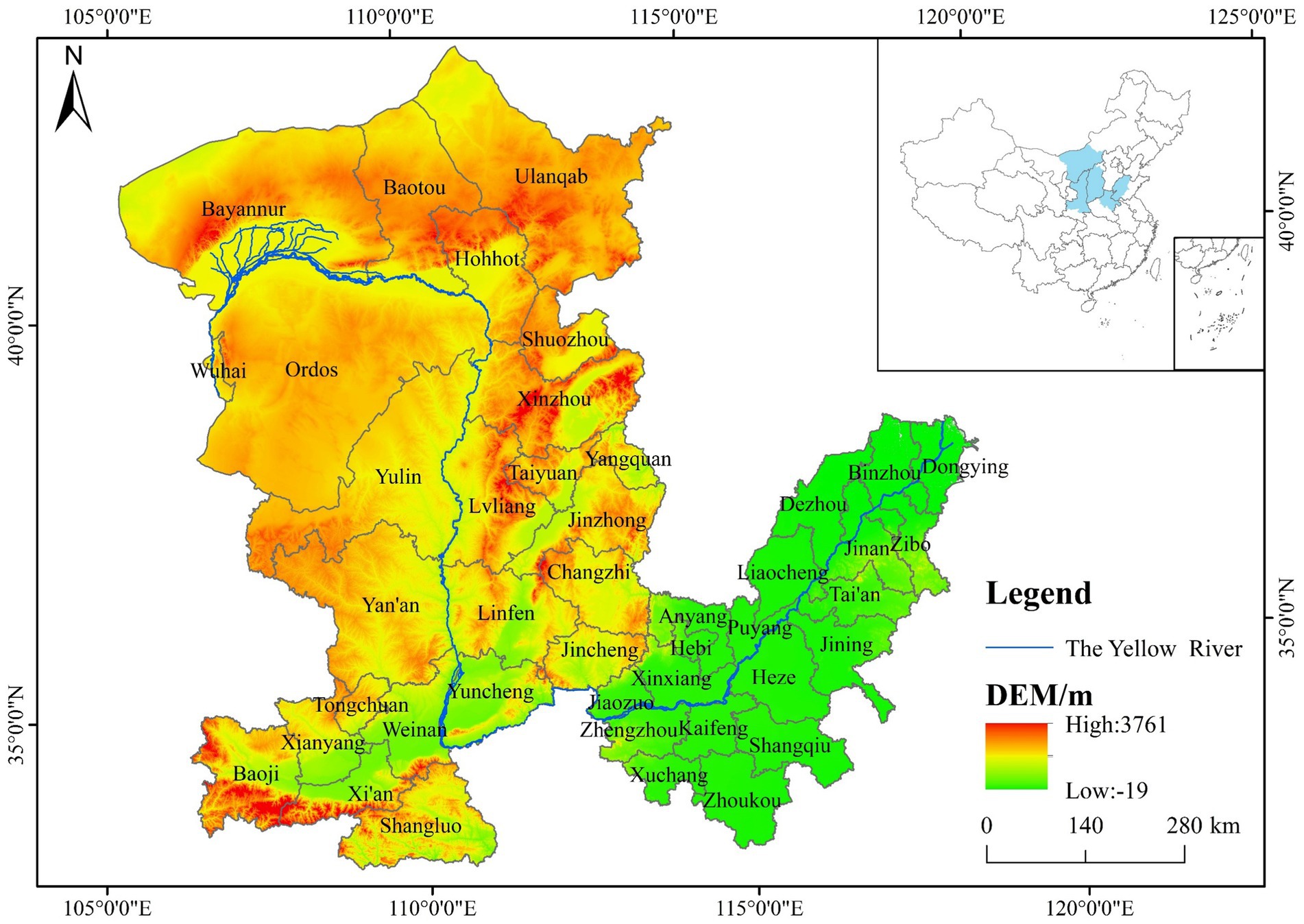
Figure 1. Study area.
Geographically, the Yellow River Basin covers approximately 790,000 square kilometers, accounting for about 8.3% of China’s total land area. Originating in Qinghai Province, the river flows through nine provinces and autonomous regions, including Gansu, Sichuan, and Ningxia. The middle and lower reaches are historically significant as the cradle of Chinese civilization and currently serve as one of China’s key grain-producing regions. The basin supports a population of about 420 million, roughly one-third of the national total, highlighting its strategic importance for national food security and rural development.
2.2 Analytical framework
2.2.1 Moran’s index
This study employs Moran’s Index (MI), a widely used statistical measure of spatial autocorrelation, to assess whether agricultural resilience in prefecture-level cities within the Yellow River Basin exhibits spatial agglomeration or dispersion (Li et al., 2023). The specific functions are presented in Equations 1, 2.
where represents the Global MI, represents the Local MI and is the number of prefecture-level cities studied. Similarly, and are the agricultural resilience levels of prefecture-level cities in cities and respectively and is their average value. When MI > 0, it indicates positive spatial correlation, with larger values reflecting stronger spatial clustering. When MI < 0, it signifies negative spatial correlation, meaning greater spatial disparity. An MI value of 0 indicates a random spatial distribution with no significant spatial pattern.
2.2.2 Dagum Gini coefficient
This study employs an empirical approach with the Dagum Gini coefficient to investigate regional disparities among prefecture-level cities and subsystems within the Yellow River Basin (Lu et al., 2024). The regional disparities are further analyzed by decomposing them into intra-regional differences, inter-regional differences, and hypervariable density contributions. The specific functions are presented in Equations 3, 4.
where G is the overall Gini coefficient. are the contributionss of intra-regional differences, inter-regional differences, and hyper-variable density, respectively. ( ) represents the i(r) research subject witin the j(h) region, is the average value of the research object, n is the number of cities, and k is the number of regions.
2.2.3 Kernel density function
To examine the changing trends and distribution characteristics of agricultural resilience levels across prefecture-level cities in the Yellow River Basin, this study adopts the Kernel density estimation method, as referenced in the work of Xu and Wang (2022). The specific functions are presented in Equations 5, 6.
where N is the number of prefecture-level cities, shows independent and equally distributed observed values, x is the average value, K(.) represents Kernel density, and h shows window width.
2.2.4 Obstacle degree model
This study utilizes an obstacle degree model to examine the internal factors that constrain agricultural resilience across various prefecture-level cities within the Yellow River Basin (Lu et al., 2024). The specific functions are presented in Equations 7, 8.
where j denotes the indicator number within a specific criterion layer, and m represents the total number of indicators. Similarly, A larger resulting O value or U value indicates a higher obstacle degree for that indicator, reflecting a greater hindering effect on agricultural resilience.
2.2.5 Spatial Durbin Model
To assess the influence of spatial correlation and exogenous variables on agricultural resilience, this study employs the Spatial Durbin Model (SDM), building on established research methodologies (Xu et al., 2023). The specific functions are presented in Equation 9.
where represents the dependent variable, represents the independent variable, is the spatial autoregressive coefficient and is the spatial weight matrix. Similarly, and represent the individual effect and time effect, respectively. is the error term. If = 0, the model degenerates into a Spatial Pane Lag Model. If =0, its further degenerates into a Spatial Panel Error Model.
2.3 Indicator system
2.3.1 Construction of the indicator system
Agricultural resilience is a multifaceted concept that spans various disciplines. Given the vast geographic scope and the diverse socio-economic conditions across the provinces in the Yellow River Basin, it is essential to account for regional heterogeneity when constructing a resilience indicator system. This study adopts the Pressure-State-Response (PSR) framework to build the indicator system, categorizing indicators into three dimensions: Pressure, which captures negative externalities such as pollution and resource depletion; State, which reflects the current status of economic development and agricultural performance; and Response, which includes efforts and policies aimed at improving resilience. To ensure objective weighting of each indicator, the entropy method is employed (Zhu et al., 2020). The calculated weights and corresponding indicators are presented in Table 1, providing a data-driven foundation for the comprehensive assessment of agricultural resilience.
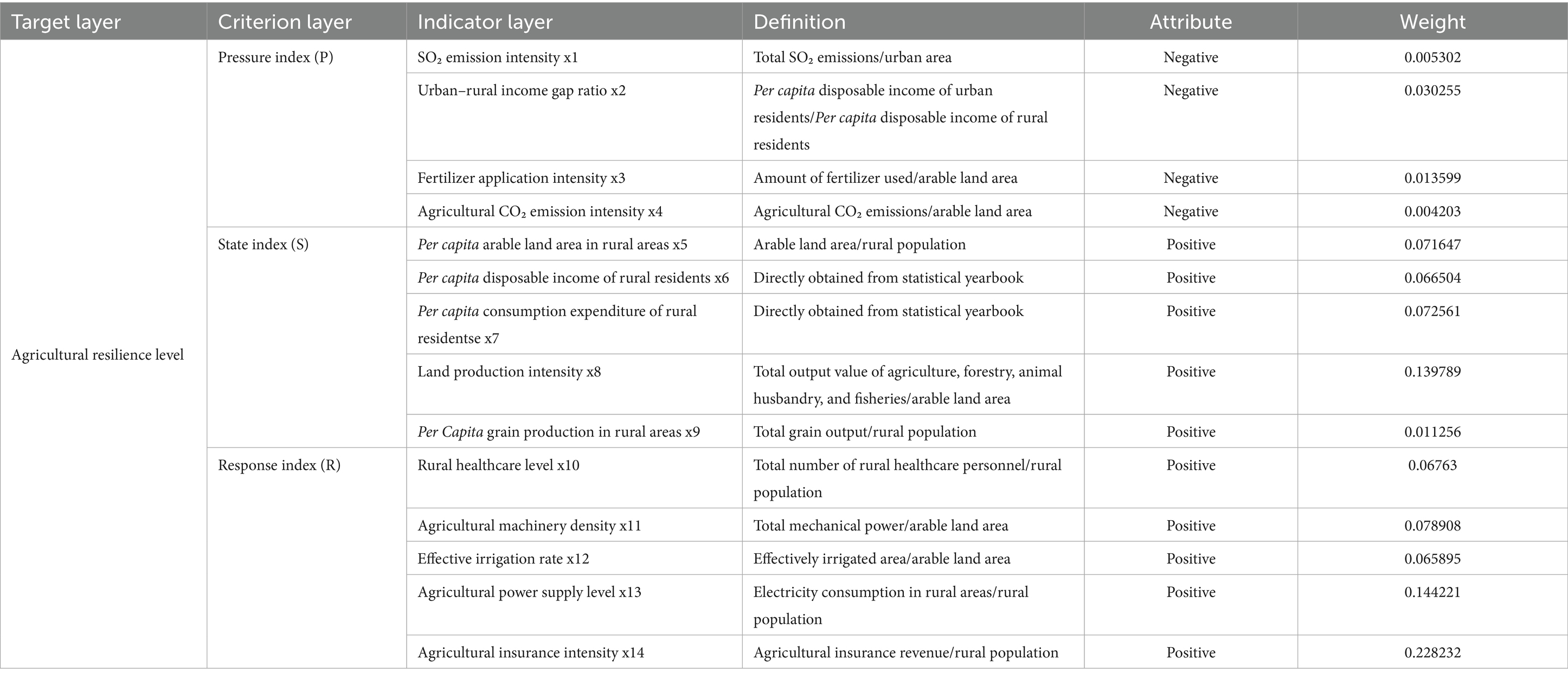
Table 1. Evaluation indicators of the agricultural resilience level.
3 Results
3.1 Time series analysis of agricultural resilience
The assessment of agricultural resilience in the Yellow River Basin was conducted using the selected indicator system and measurement methods, with the findings presented in Figure 2. The resilience level increased from 0.1993 in 2012 to 0.3986 in 2022, reflecting a 200% rise. Although there were some fluctuations over time, the overall trend indicates significant growth. This upward trajectory became especially pronounced after October 2021.
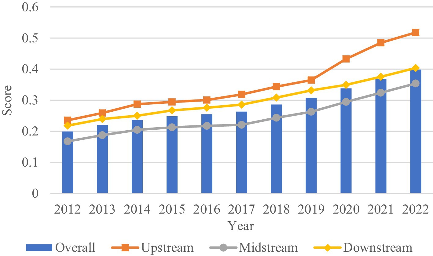
Figure 2. Time series trends of agricultural resilience in the Yellow River Basin and its sub-regions.
The three major regions within the study area—upstream, midstream, and downstream—exhibit similar upward trends in agricultural resilience over time, though the rate of growth varies significantly among them. In the upstream region, primarily represented by the Inner Mongolia Autonomous Region, agricultural resilience increased from 0.2353 in 2012 to 0.5177 in 2022, reflecting a growth of approximately 220%. This upward momentum accelerated notably after 2019, positioning Inner Mongolia as the fastest-growing region in terms of resilience. This rapid progress is likely driven by the region’s recent efforts to promote digital agriculture and improve agricultural infrastructure.
In the midstream region, which includes Shaanxi and Shanxi provinces, agricultural resilience rose from 0.1674 in 2012 to 0.3538 in 2022, representing a growth of approximately 211%. This improvement has been significantly influenced by targeted government initiatives, such as Shaanxi Province’s 14th Five-Year Plan for Digital Agriculture and Rural Development (April 2022) and Shanxi Province’s 14th Five-Year Plan for Promoting Agricultural and Rural Modernization (September 2022), both of which have contributed to enhancing the region’s agricultural adaptability and sustainability. In the downstream region, covering the prefecture-level cities of Henan and Shandong provinces, agricultural resilience steadily increased from 0.2180 in 2012 to 0.4034 in 2022, marking an overall growth of about 185%. This improvement is largely attributed to policy support, including Henan Province’s 14th Five-Year Plan for Rural Revitalization and Agricultural and Rural Modernization (Wei et al., 2020) and Shandong Province’s Five-Year Action Plan for Promoting High-Quality Development of the Entire Agricultural Industry Chain (October 2021), which have provided strategic frameworks to guide agricultural modernization and enhance resilience.
To assess the spatial distribution and evolution of agricultural resilience across prefecture-level cities in the Yellow River Basin, this study applies the natural break classification method using ArcGIS. Agricultural resilience levels are categorized into four tiers, and the years 2012, 2017, and 2022 are selected to visualize spatial changes. As shown in Figure 3, the highest resilience levels are concentrated in the downstream cities of Shandong Province and the upstream cities of Inner Mongolia, while lower levels are primarily observed in the midstream region of Shanxi Province. This spatial distribution highlights pronounced regional disparities, with relatively stronger resilience in the upstream and downstream areas and weaker performance concentrated in the midstream.
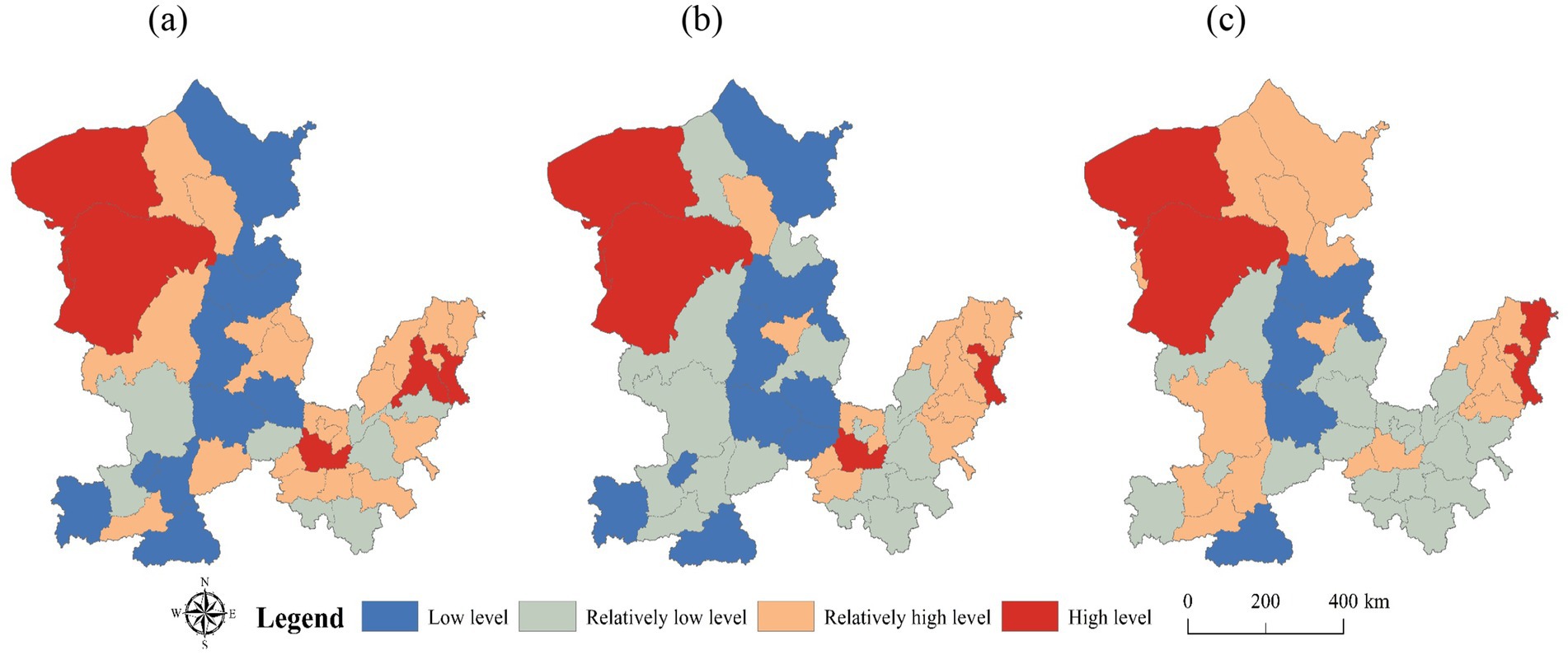
Figure 3. Spatial distribution of agricultural resilience.
3.2 Spatial effect analysis of agricultural resilience
The global autocorrelation index of agricultural resilience levels for urban agglomerations along the Yellow River Basin, as presented in Table 2, reveals significant spatial patterns over the period from 2012 to 2022. The global MI for the study area remained significantly positive at the 1% level (p < 0.01) throughout the study period, and it successfully passed the Z-statistic test. This suggests a notable and stable positive spatial agglomeration effect, meaning that improvements in agricultural resilience in one prefecture-level city tend to have a significant and stable positive impact on the agricultural resilience of neighboring cities. Furthermore, the upward trend in the global MI over time indicates that spatial autocorrelation has strengthened, underscoring an increasing interdependence among these urban areas in terms of agricultural resilience improvements during the study period.
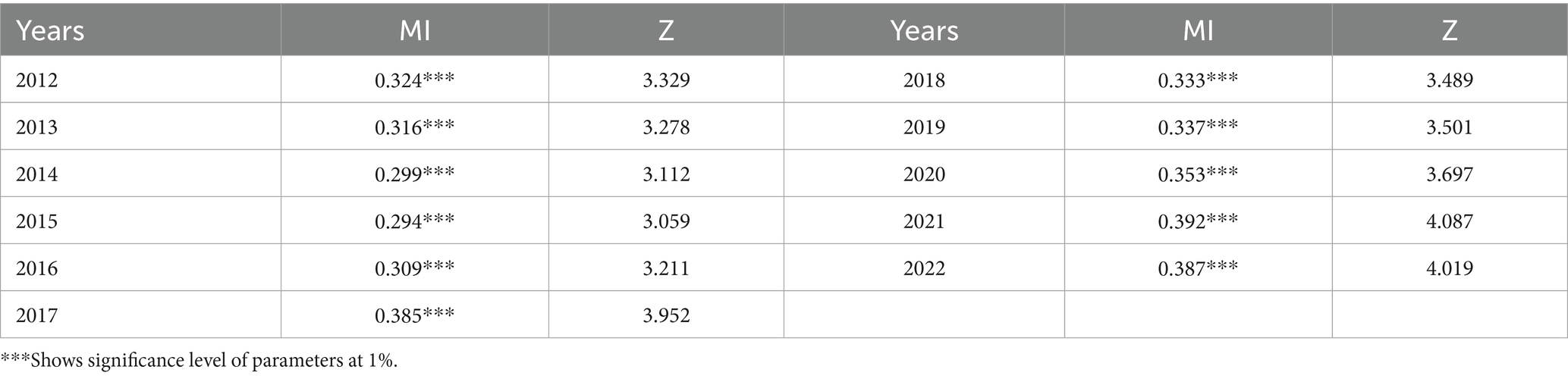
Table 2. Global MI of the Yellow River Basin from 2012 to 2022.
Since the global MI only captures the overall spatial clustering of agricultural resilience in urban areas along the Yellow River Basin and does not provide insights into individual prefecture-level cities, this study expands the analysis by incorporating the local Moran’s Index.
Table 3 highlights the spatial agglomeration and heterogeneity of agricultural resilience across 43 prefecture-level cities in the Yellow River Basin. Most cities fall into either the first quadrant (High-High, HH) or the third quadrant (Low-Low, LL), indicating a significant positive spatial correlation and notable clustering effects. In 2012, 16 cities located in the upstream (Inner Mongolia) and downstream (Henan and Shandong) regions were classified within the HH quadrant, forming a high-resilience belt driven by favorable natural resource endowments, diversified agricultural systems, and strong government support. In contrast, 14 cities in the midstream region (Shaanxi and Shanxi) were situated in the LL quadrant, where difficult terrain, harsh climatic conditions, and water scarcity hindered agricultural development and lowered resilience levels.
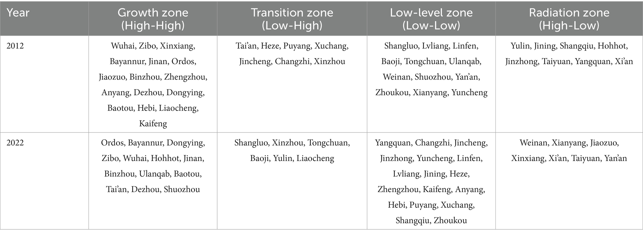
Table 3. Quadrant of local MI.
By 2022, most cities in the HH quadrant were concentrated in Inner Mongolia and Shandong, while several cities in Henan shifted into the lower quadrants. This transition reflects increasing pressures that have intensified the gap between traditional agricultural models and the demands of modernization. Resource constraints and environmental degradation have become more pronounced. As one of China’s major grain-producing provinces, Henan has long experienced intensive land use, leading to significant land degradation. By 2016, over 60% of the province’s farmland was classified as medium-or low-yield. Furthermore, issues such as groundwater over-extraction and the growing frequency of extreme weather events due to climate change have further eroded the agricultural production base.
In addition to environmental pressures, the outflow of production factors has weakened local resilience. Between 2012 and 2022, the proportion of Henan’s rural labor force working outside the province rose from 35 to 52%, leading to a hollowing out of rural areas. Mechanization has yet to fully compensate for the loss of labor, and agricultural structural transformation has lagged behind. Wheat and corn continue to dominate over 70% of the cultivated land, while economic crops and facility agriculture remain underdeveloped, reducing the sector’s capacity to manage market fluctuations.
Policy-related challenges have further compounded these issues. While the grain security accountability system has emphasized production targets, accompanying measures such as ecological compensation and technological advancement have not been adequately implemented. This lack of coordination has weakened the sustainability of agricultural systems. Amid accelerated urbanization and shifting consumption patterns, traditional agricultural practices are increasingly unable to withstand complex and evolving risks, resulting in a systemic decline in agricultural resilience.
Overall, the analysis reveals a persistent pattern of higher agricultural resilience in the upstream and downstream regions and lower resilience in the midstream. This spatial differentiation emphasizes the need for region-specific strategies to address varying development constraints.
Moreover, some cities exhibited spatial anomalies. For instance, Low-High (LH) cities such as Tai’an and Heze in 2012, and Shangluo and Xinzhou in 2022, as well as High-Low (HL) cities like Yulin and Jining, deviated from the dominant regional trends. These anomalies are largely attributed to the weak radiation effect of high-resilience areas, a homogeneous agricultural structure, and a lack of coordinated development between high-and low-resilience zones.
3.3 Regional differences in agricultural resilience
This study employs the Dagum Gini coefficient decomposition method to assess regional disparities in agricultural resilience across 43 prefecture-level cities in the Yellow River Basin. The results, shown in Tables 4, 5, offer key insights into the extent and nature of these regional differences.
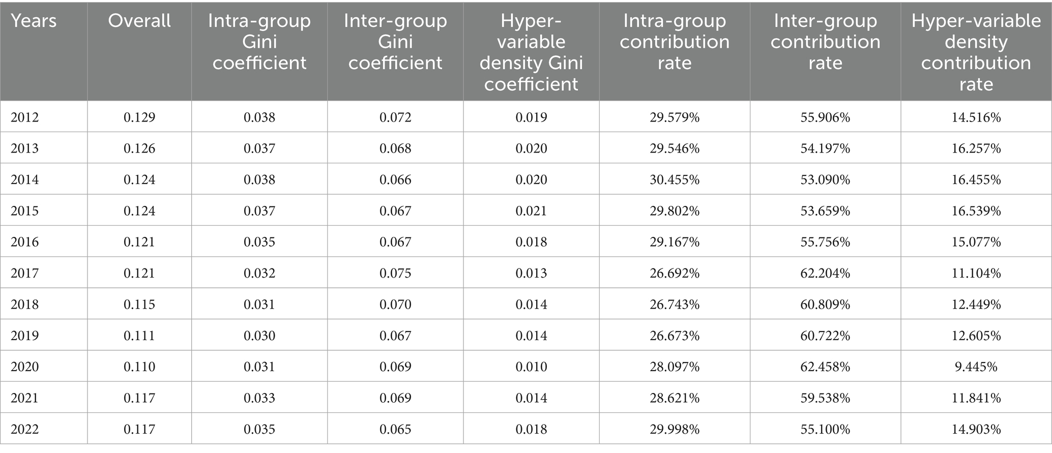
Table 4. The Results of Dagum Gini coefficient and contribution rate.
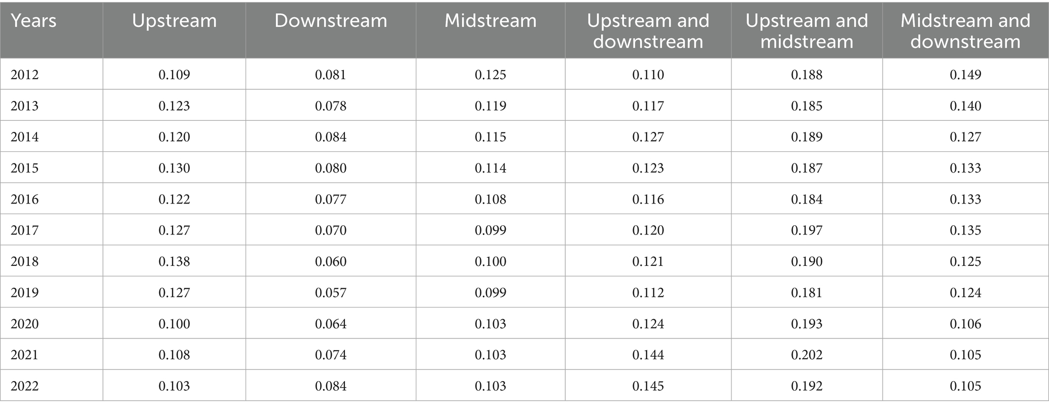
Table 5. Intra-and inter-regional differences in agricultural resilience across the Yellow River Basin based on Dagum Gini coefficient decomposition.
3.3.1 Intra-regional differences
As shown in Table 4, over the 11 years from 2012 to 2022, the overall Gini coefficient for the study area decreased from 0.129 to 0.117, representing a 10.26% reduction. The average Gini coefficient was 0.1195, fluctuating between 0.129 and 0.11, with a pattern of “decline-rise-decline.” This indicates that while some spatial imbalances in agricultural resilience remain, the overall gap is narrowing.
Regarding intra-regional differences, the upstream region had the highest average internal disparity (mean value of 0.119), followed by the midstream region (0.108), and the downstream region with the smallest internal difference (0.074). As shown in Table 5, the downstream region consistently exhibited the smallest internal differences, which decreased from 2012 to 2019 but began to rise again from 2019 to 2022. In 2012, the midstream region had the largest internal disparity, but by 2013, the upstream region surpassed it, with the gap widening until 2020, when the internal differences between the upstream and midstream regions became similar again.
3.3.2 Inter-regional differences
As shown in Table 5, the average Gini coefficients for inter-regional differences from 2012 to 2022 rank as follows: upstream-midstream (0.19) > midstream-downstream (0.126) > upstream-downstream (0.124). This indicates that the largest gap in agricultural resilience exists between the upstream and midstream regions. The primary reason may be the climatic differences, with the cold temperate continental climate of Inner Mongolia contrasting with the warm temperate semi-humid climate of Shaanxi and Shanxi in the midstream (Wu et al., 2023). These climate variations influence agricultural practices, leading to significant differences in resilience. Additionally, severe soil erosion and water scarcity in the midstream region exacerbate these disparities.
In terms of trends, the Gini coefficients for the upstream-downstream and upstream-midstream regions displayed an upward trajectory, while the midstream-downstream region experienced a decline. This suggests that the gap between upstream and both the midstream and downstream regions is widening, while the difference between midstream and downstream is narrowing. Thus, there is a broad imbalance in agricultural resilience across the Yellow River Basin, with particular focus needed on improving coordination between the upstream and other regions (Huang et al., 2023).
3.4 Time evolution trend based on kernel density estimation
To gain deeper insights into the evolution of agricultural resilience across the 43 prefecture-level cities, Kernel density curves for 2012, 2015, 2018, and 2022 were generated for both the entire basin and its regions. As illustrated in Figures 4A–D, the Kernel density curves for the overall basin and its regions consistently shift to the right over time, signaling continuous improvement in agricultural resilience. Notably, the midstream region exhibits a more pronounced rightward shift, indicating a faster rate of improvement in agricultural resilience compared to other regions.
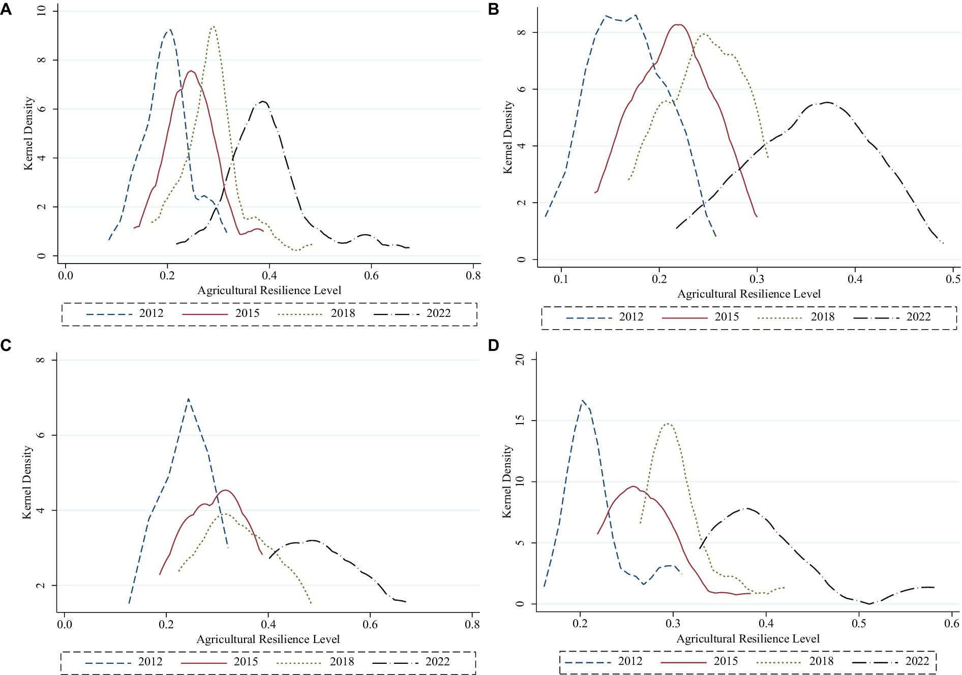
Figure 4. (A) Kernel density plot of overall agricultural resilience level in the Yellow River Basin. (B) Kernel density plot of agricultural resilience level in the upstream regions of the Yellow River Basin. (C) Kernel density plot of agricultural resilience level in the midstream regions of the Yellow River Basin. (D) Kernel density plot of agricultural resilience level in the downstream regions of the Yellow River Basin.
The peak morphology of the curves reveals a “decline-rise-decline” pattern in the main peak values for cities across the basin, with an overall downward trend. The side peak values are smaller, shifting rightward and broadening in width, indicating a decrease in concentration and a slight gradient effect in agricultural resilience levels. In the upstream and midstream regions, the main peak values decrease, broaden, and shift to the right, reflecting improvements in agricultural resilience but also widening internal disparities. In the downstream region, the main peak values follow the same “decline-rise-decline” pattern, with a broader width and a rightward shift in the main peak, though the side peaks remain small. This indicates that while agricultural resilience has improved in the downstream regions, the concentration has decreased, with a slight gradient effect evident.
3.5 Analysis of factors influencing agricultural resilience in the Yellow River Basin
3.5.1 Analysis of internal constraining factors
This study focuses on the years 2012, 2017, and 2022, applying the obstacle degree model to identify internal constraining factors at the indicator level for 43 prefecture-level cities along the Yellow River Basin. The top three obstacle factors for each city are determined based on their respective obstacle degree levels.
The results in Table 6 reveal that the top three factors influencing the obstacle degree of agricultural resilience are agricultural insurance intensity (x14), effective irrigation rate (x12), and land productivity intensity (x8). This suggests that improving agricultural resilience along the Yellow River Basin requires enhancing these key areas. First, a comprehensive agricultural insurance system should be established, offering tailored products for different regions, crops, and agricultural needs to better serve farmers and increase the appeal of insurance. Second, investments in rural infrastructure, particularly irrigation systems—such as channels, ponds, and reservoirs—must be strengthened to optimize arable land conditions.
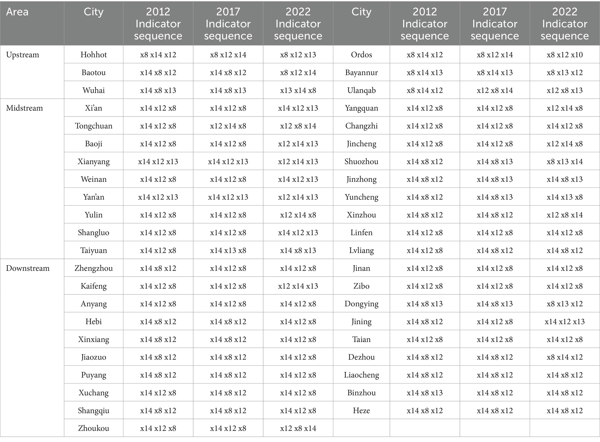
Table 6. The sequence of obstacle factors for selected years.
Regionally, the main factors influencing resilience in upstream cities shifted from land productivity intensity (x8), agricultural insurance intensity (x14), and effective irrigation rate (x12) to land productivity intensity (x8), effective irrigation rate (x12), and agricultural power supply level (x13). This highlights the need for improved fertilization practices, irrigation, and power infrastructure in the upstream region. In midstream cities, the key factors evolved from agricultural insurance intensity (x14), effective irrigation rate (x12), and land productivity intensity (x8) to agricultural insurance intensity (x14), effective irrigation rate (x12), and agricultural power supply level (x13). This underscores the importance of building a robust insurance service system, streamlining claims processes, and enhancing farmers’ trust in insurance services.
For downstream cities, the main influencing factors remained consistent with the midstream, shifting slightly from agricultural insurance intensity (x14), land productivity intensity (x8), and effective irrigation rate (x12) to agricultural insurance intensity (x14), effective irrigation rate (x12), and land productivity intensity (x8). This similarity between the midstream and downstream regions may stem from shared challenges, such as water resource shortages, soil quality issues, climate change, and natural disasters, all of which affect agricultural resilience in both areas.
3.6 Analysis of external constraining factors
3.6.1 Selection of influencing factors
Agricultural resilience is a key component of China’s high-quality agricultural development, emphasizing agriculture’s capacity for resistance, recovery, and regeneration in the face of external uncertainties (Zhao and Zhao, 2024). Various local social and economic factors influence the level of agricultural resilience. To estimate the external drivers of agricultural resilience in cities along the Yellow River Basin, this study selects five explanatory indicators, each expressed in logarithmic form:
First, Urbanization Level (URB) is measured as the percentage of the urban population relative to the total population, consistent with established research methodologies (Morris et al., 2017; Wang and Yang, 2019). This indicator reflects the degree of urbanization within the study area. Urbanization contributes to agricultural modernization and industrial upgrading, thereby enhancing production efficiency, improving product quality, and increasing the agricultural sector’s competitiveness and capacity to withstand external risks (Wan, 2022).
Second, the Economic Development Level (INC) is represented by per capita GDP. Economic growth plays a crucial role in improving agricultural infrastructure and promoting the adoption of advanced technologies. These developments boost productivity, optimize management and supply chain systems, and ultimately strengthen agricultural resilience (Wang et al., 2023).
Third, Industrialization Level (INS), following the definition by Qin Tian, is expressed as the share of secondary industry in GDP. While industrialization supports technological advancement and greater mechanization in agriculture—contributing positively to risk resistance (Lewis et al., 2022)—it can also introduce challenges such as land use conflicts and rural depopulation, which may negatively affect agricultural resilience.
Fourth, the Agricultural Human Capital Level (HCM) is defined as the proportion of the labor force employed in the primary industry, in accordance with established practices (Collins et al., 2017; Baldoni et al., 2017). This indicator captures the availability and distribution of human capital within the agricultural sector. Skilled labor is essential for maintaining and enhancing resilience through effective farm management and adaptation to change.
Finally, Economic Structural Change (CSE) is measured by the ratio of agricultural value-added to regional GDP, serving as an indicator of the agricultural sector’s relative contribution to the broader economy. A higher share of agricultural value-added reflects a more agriculture-oriented economic structure, which enhances adaptability to market fluctuations and strengthens resilience (German et al., 2020).
Together, these five indicators form a comprehensive framework for evaluating the external factors influencing agricultural resilience across prefecture-level cities in the Yellow River Basin.
3.6.2 Model testing
As shown in Table 7, applying the spatial adjacency matrix reveals that the LM-spatial lag, Robust LM-spatial lag, LM-spatial error, and Robust LM-spatial error are all significant at the 0.01 level (p < 0.01) in the LM test results. This confirms the strong robustness of the models, indicating that the agricultural resilience of the 43 prefecture-level cities along the Yellow River Basin demonstrates significant spatial error and spatial lag effects.
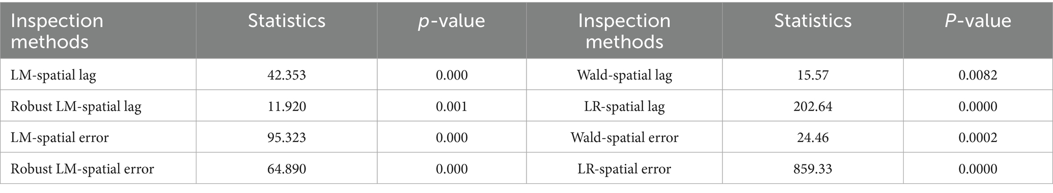
Table 7. Results of LM and LR of the spatial panel econometric model.
Before selecting the appropriate model, it is essential to conduct a rational model comparison. In this study, the likelihood ratio (LR) test was used to determine whether the Spatial Durbin Model (SDM) could be simplified to a Spatial Error Model (SEM) or a Spatial Autoregressive Model (SAR). As shown in the results table, the Wald-spatial lag, LR-spatial lag, Wald-spatial error, and LR-spatial error tests were all significant at the 1% level (p < 0.01), thereby strongly rejecting the null hypothesis that the SDM could be reduced to either SEM or SAR.
Additionally, based on the significance of test results, the Hausman test, and the economic relevance of explanatory variables, a comparison was made among individual fixed effects, time fixed effects, and two-way fixed effects models. The findings indicated that the time-fixed effects model was the most appropriate specification for the data used in this study.
3.6.3 Impact of external factors on agricultural resilience
The analysis of the Spatial Durbin Model indicates that the selected external factors exert different influences on the agricultural resilience of cities along the Yellow River Basin. As outlined in Table 8, urbanization has a notable impact, with a direct effect of 0.1305, which is statistically significant at the 1% level. A 1% increase in the urbanization rate leads to a 13.5% improvement in agricultural resilience in the region, with a spatial spillover effect of 0.015. Urbanization promotes population agglomeration and economic growth, increasing the demand for agricultural products while also fostering better technological support through the concentration of resources such as agricultural research institutions. These advancements in technology and management contribute to improved agricultural productivity and resilience.
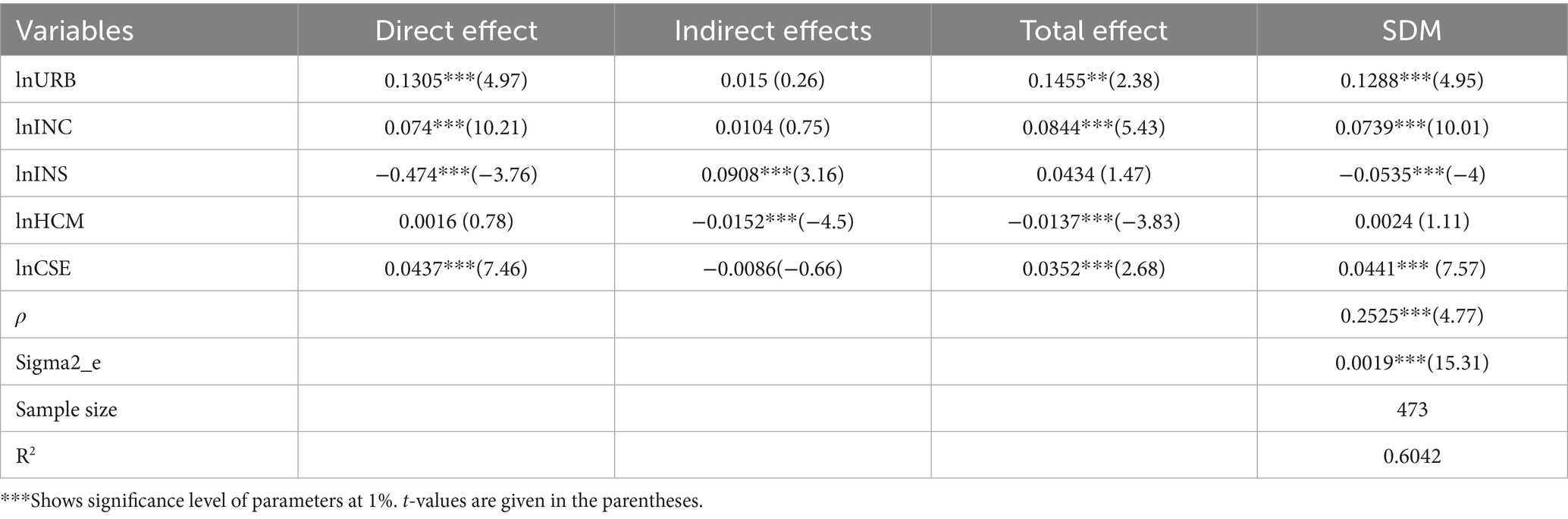
Table 8. The direct and indirect effects of the Spatial Durbin Model.
Economic development also has a direct positive impact on agricultural resilience. As economic development advances, it leads to increased investments in infrastructure, technological innovation, and human resource training, which in turn bolster agricultural productivity and disaster resilience. Moreover, economic development generates a spatial spillover effect, as cities with more advanced agricultural technologies and management practices can assist neighboring cities through cooperation and the spread of technology, thereby improving resilience across the region.
Industrialization has a complex impact, with a negative direct effect but a positive spatial spillover effect on agricultural resilience. The negative direct impact is due to the use of land for urbanization and industrial activities, which can lead to environmental degradation, reduced arable land, and limited agricultural development. However, industrialized regions often possess advanced agricultural technologies and expertise that, when shared with neighboring regions, improve their agricultural production efficiency, anti-disaster capabilities, and overall resilience.
A significant negative spatial spillover effect characterizes the impact of agricultural human capital on resilience. A 1% increase in the proportion of the workforce employed in the primary sector in one region corresponds to a 1.52% decrease in the agricultural resilience of neighboring areas. This may occur because regions with higher primary sector employment place increased demand on agrarian resources, reducing availability in adjacent areas and thus lowering their resilience. Lastly, economic structural changes have a significantly positive direct effect on agricultural resilience. A higher proportion of agricultural value-added reflects the importance of agriculture in the regional economy and indicates a more diversified economic structure (Delgado, 1999). This diversification supports agriculture by reducing dependency on a single sector and providing resources from other industries, which strengthens resilience (De Roest et al., 2018). However, the spatial spillover effects of economic structural changes on neighboring cities are not significant, suggesting that these impacts are largely confined to the city itself. Overall, the analysis shows that urbanization, economic development, and industrialization influence agricultural resilience in varying ways, with significant direct and spillover effects, while human capital and economic structure primarily affect resilience through more localized impacts.
4 Discussion
This study reveals that agricultural resilience across prefecture-level cities in the Yellow River Basin has generally improved over time, with notable spatial heterogeneity. The upward trend observed from 2012 to 2022 aligns with broader national efforts to modernize agriculture and promote rural revitalization. The more pronounced increase after 2021 may be attributed to policy intensification and the implementation of high-quality development strategies in the basin.
The regional variation in resilience levels—stronger in the upstream and downstream, and weaker in the midstream—is consistent with findings from Zhou and Guo (2024), who emphasized the role of digital infrastructure and resource allocation in shaping resilience patterns. Inner Mongolia’s significant gains can be linked to its early adoption of digital agriculture and infrastructure improvements, while downstream regions like Shandong have benefited from industrial linkages and robust policy frameworks (Wei et al., 2020).
The significant spatial autocorrelation detected by Moran’s Index suggests that agricultural resilience is not randomly distributed but rather exhibits strong spatial clustering. This confirms the presence of spatial spillover effects, as cities with high resilience tend to influence neighboring cities positively. This supports the spatial interdependence model proposed by Du et al. (2023), who demonstrated similar spillovers in studies on digital financial inclusion and economic resilience.
Local indicators of spatial association further confirm the persistent High-High (HH) and Low-Low (LL) clusters. Cities such as Ordos and Zibo remained consistently in the HH category, while cities in midstream areas like Yuncheng and Linfen showed prolonged LL characteristics. These findings reflect the impact of long-standing disparities in natural endowments, infrastructure, and policy effectiveness across regions. The Dagum Gini coefficient analysis shows that overall regional disparities in resilience have narrowed over the past decade, with notable fluctuations. The most significant differences remain between the upstream and midstream regions, possibly due to climatic contrasts (Wu et al., 2023) and varying levels of soil degradation and water scarcity.
The Kernel density estimation indicates polarization in resilience levels—especially in the midstream—where the widening gap between high-and low-performing cities calls for targeted interventions. This gradient effect supports the findings of Sui et al. (2023), who emphasized east–west spatial asymmetries in resilience across the Yellow River Basin.
In terms of internal barriers, agricultural insurance intensity, irrigation efficiency, and land productivity remain the top obstacles. These results reaffirm the conclusions of Gao and Gao (2024), who underscored the need for better risk-sharing mechanisms and basic infrastructure in bolstering resilience. Externally, Spatial Durbin Model results highlight urbanization and economic development as positive drivers with both direct and spillover effects. These findings align with Morris et al. (2017) and Wan (2022), who argued that urbanization fosters infrastructure, innovation, and market connectivity. Interestingly, industrialization shows a negative direct effect but positive spillovers, indicating that while local agricultural areas may suffer from industrial encroachment, neighboring cities benefit from technology and knowledge transfers.
Agricultural human capital was found to have a negative spatial spillover effect, likely due to rural labor outmigration and inefficient human resource distribution. Finally, economic structural change—measured by the share of agricultural value-added—had a positive local impact, reinforcing the role of diversified agricultural economies in sustaining resilience (German et al., 2020).
5 Conclusion and policy implications
This study set out to explore the spatiotemporal evolution, regional disparities, and influencing factors of agricultural resilience across 43 prefecture-level cities in the Yellow River Basin over the period from 2012 to 2022. Drawing on the conceptual framework of the Pressure-State-Response (PSR) model, the research developed a comprehensive indicator system to measure agricultural resilience. A range of analytical methods was employed, including entropy weighting for indicator aggregation, the Dagum Gini coefficient for regional difference decomposition, Kernel density estimation for dynamic distribution analysis, Moran’s I and Local Indicators of Spatial Association (LISA) for spatial correlation analysis, the obstacle degree model for identifying internal constraints, and the Spatial Durbin Model for assessing the impact of external factors.
The results demonstrate that agricultural resilience in the Yellow River Basin has shown a clear upward trend during the study period, with upstream regions such as Inner Mongolia experiencing the most rapid improvement, followed by the midstream and downstream areas. Spatial clustering was evident, with resilience levels exhibiting significant positive spatial autocorrelation and spillover effects, particularly in upstream and downstream cities. The gap in resilience between regions narrowed overall; however, the disparity between upstream and midstream cities remained pronounced, driven by factors such as climatic differences, infrastructure availability, and ecological vulnerability. Internal barriers to resilience were consistently found to be agricultural insurance intensity, effective irrigation rate, and land productivity intensity. Externally, urbanization and economic development contributed positively to resilience, both directly and through spatial spillovers, while industrialization had a negative direct effect due to land pressure and environmental degradation, yet a positive spillover effect through technological diffusion. Agricultural human capital had a negative spatial spillover, suggesting regional competition or resource strain, and economic structural change showed a positive local effect but limited influence across neighboring areas.
The findings of this study offer important implications for agricultural and regional development policy in China. Addressing resilience disparities requires region-specific strategies that reflect the varied natural, economic, and institutional conditions across the basin. In the upstream regions, enhancing drought resistance through improved irrigation systems and resilient crop varieties is critical. The midstream areas, facing severe ecological degradation and soil erosion, need intensified environmental restoration and soil conservation efforts. In the downstream regions, where economic development is relatively advanced, promoting agricultural diversification and integrating agriculture with modern industrial chains will help mitigate risks associated with over-reliance on single-sector production. The presence of spatial spillover effects underscores the need for coordinated regional planning and inter-city collaboration. Strengthening factor mobility, cross-regional agricultural cooperation, and technological exchange can help distribute resilience-enhancing practices more effectively throughout the basin. Investments in insurance systems, irrigation infrastructure, and rural land productivity will also be essential in building a more stable and adaptable agricultural sector. Furthermore, while industrialization and urbanization are key drivers of transformation, they must be managed in a way that safeguards agricultural resources and promotes inclusive growth.
Despite the strengths of this study, there are several limitations that should be acknowledged. The study primarily relied on prefecture-level data, which may mask important intra-city variations at the county or village level. Moreover, certain relevant variables such as the impacts of climate change, policy enforcement, or environmental shocks were not fully captured due to data constraints. Future research could extend the scope to include other major river basins for comparative analysis, integrate climatic and environmental datasets to capture broader ecological influences, and employ more granular data to explore resilience dynamics at the local level. These enhancements would provide deeper insights into the multi-dimensional nature of agricultural resilience and support more precise and effective policy design.
Data availability statement
The datasets presented in this study can be found in online repositories. The names of the repository/repositories and accession number(s) can be found in the article/Supplementary material.
Author contributions
CM: Conceptualization, Resources, Writing – original draft, Formal analysis. SW: Validation, Supervision, Conceptualization, Software, Resources, Visualization, Writing – review & editing. XH: Conceptualization, Data curation, Writing – original draft, Software.
Funding
The author(s) declare that financial support was received for the research and/or publication of this article. The study is financially supported by the Taishan Young Scholar Program, the Taishan Scholar Foundation of Shandong Province, China. Moreover, financial support from the Shandong Province Humanities and Social Sciences Think Tank Key Project: Research on the Tracking Evaluation and Path Optimization of Ecological Protection and High-Quality Development in the Yellow River Basin (2023-2k2d-010) is highly acknowledged.
Conflict of interest
The authors declare that the research was conducted in the absence of any commercial or financial relationships that could be construed as a potential conflict of interest.
Generative AI statement
The author(s) declare that no Gen AI was used in the creation of this manuscript.
Publisher’s note
All claims expressed in this article are solely those of the authors and do not necessarily represent those of their affiliated organizations, or those of the publisher, the editors and the reviewers. Any product that may be evaluated in this article, or claim that may be made by its manufacturer, is not guaranteed or endorsed by the publisher.
Supplementary material
The Supplementary material for this article can be found online at: https://www.frontiersin.org/articles/10.3389/fsufs.2025.1614493/full#supplementary-material
References
Baldoni, E., Coderoni, S., and Esposti, R. (2017). Immigrant workforce and labour productivity in Italian agriculture: a farm-level analysis. Bio-Based Applied Economics 6. Available at: https://www.torrossa.com/en/resources/an/4376295#page=33
Chen, L., Wang, Q., Zhu, G., Lin, X., Qiu, D., Jiao, Y., et al. (2023). Dataset of stable isotopes of precipitation in the Eurasian continent. Earth System Science Data Discussions 2023, 1–24. doi: 10.5194/essd-16-1543-2024
Chen, L., Zhu, G., Lin, X., Li, R., Lu, S., Jiao, Y., et al. (2024). The complexity of moisture sources affects the altitude effect of stable isotopes of precipitation in inland mountainous regions. Water Resour. Res. 60:e2023WR036084. doi: 10.1029/2023WR036084
Collins, N., Jones, S., Nguyen, T. H., and Stanton, P. (2017). The contribution of human capital to a holistic response to climate change: learning from and for the Mekong Delta, Vietnam. Asia Pac. Bus. Rev. 23, 230–242. doi: 10.1080/13602381.2017.1299449
De Roest, K., Ferrari, P., and Knickel, K. (2018). Specialisation and economies of scale or diversification and economies of scope? Assessing different agricultural development pathways. J. Rural. Stud. 59, 222–231. doi: 10.1016/j.jrurstud.2017.04.013
Delgado, C. L. (1999). Sources of growth in smallholder agriculture in sub-Saharan Africa: the role of vertical integration of smallholders with processors and marketers of high value-added items. Agrekon 38, 165–189. doi: 10.1080/03031853.1999.9524913
Du, C., Bai, X., Li, Y., Tan, Q., Zhao, C., Luo, G., et al. (2024). The restoration of karst rocky desertification has enhanced the carbon sequestration capacity of the ecosystem in southern China. Glob. Planet. Change 243:104602. doi: 10.1016/j.gloplacha.2024.104602
Du, Y., Wang, Q., and Zhou, J. (2023). How does digital inclusive finance affect economic resilience: evidence from 285 cities in China. Int. Rev. Financ. Anal. 88:102709. doi: 10.1016/j.irfa.2023.102709
Feng, X., Wang, Z., Wu, X., Huang, S., Li, J., Lai, C., et al. (2025). Tracking 3D drought events across global river basins: climatology, spatial footprint, and temporal changes. Geophys. Res. Lett. 52:e2024GL111442. doi: 10.1029/2024GL111442
Gao, X., and Gao, R. (2024). A study of the impact of digital financial inclusion on the resilience of the agricultural chain. Front. Sustain. Food Syst. 8:1448550. doi: 10.3389/fsufs.2024.1448550
Gao, K., Li, G., Cao, Y., Li, C., Chen, D., Wu, G., et al. (2024). Permafrost thawing caused by the China-Russia crude oil pipeline based on multi-type data and its impacts on geomorphological reshaping and water erosion. Catena 242:108134. doi: 10.1016/j.catena.2024.108134
German, L. A., Bonanno, A. M., Foster, L. C., and Cotula, L. (2020). “Inclusive business” in agriculture: evidence from the evolution of agricultural value chains. World Dev. 134:105018. doi: 10.1016/j.worlddev.2020.105018
Holling, C. S. (1996). Engineering resilience versus ecological resilience. Engineering within Ecological Constraints 31:32.
Huang, J., Zhong, P., Zhang, J., and Zhang, L. (2023). Spatial-temporal differentiation and driving factors of ecological resilience in the Yellow River Basin, China. Ecol. Indic. 154:110763. doi: 10.1016/j.ecolind.2023.110763
Jiang, C., Wang, Y., Yang, Z., and Zhao, Y. (2023). Do adaptive policy adjustments deliver ecosystem-agriculture-economy co-benefits in land degradation neutrality efforts? Evidence from southeast coast of China. Environ. Monit. Assess. 195:1215. doi: 10.1007/s10661-023-11821-6
Lewis, D., Biggs, S., and Justice, S. E. (2022). Rural mechanization for equitable development: disarray, disjuncture, and disruption. Dev. Pol. Rev. 40:e12612. doi: 10.1111/dpr.12612
Li, H., Wang, Z., Zhu, M., Hu, C., and Liu, C. (2023). Study on the spatial–temporal evolution and driving mechanism of urban land green use efficiency in the Yellow River Basin cities. Ecol. Indic. 154:110672. doi: 10.1016/j.ecolind.2023.110672
Liu, G., Jiang, E., Li, D., Li, J., Wang, Y., Zhao, W., et al. (2025). Annual multi-objective optimization model and strategy for scheduling cascade reservoirs on the Yellow River mainstream. J. Hydrol. 659:133306. doi: 10.1016/j.jhydrol.2025.133306
Lu, F., Liu, Q., and Wang, P. (2024). Spatiotemporal characteristics of ecological resilience and its influencing factors in the Yellow River Basin of China. Sci. Rep. 14:16988. doi: 10.1038/s41598-024-67628-z
Morris, K. I., Chan, A., Morris, K. J. K., Ooi, M. C., Oozeer, M. Y., Abakr, Y. A., et al. (2017). Impact of urbanization level on the interactions of urban area, the urban climate, and human thermal comfort. Appl. Geogr. 79, 50–72. doi: 10.1016/j.apgeog.2016.12.007
Pang, Q., Zhao, G., Wang, D., Zhu, X., Xie, L., Zuo, D., et al. (2024). Water periods impact the structure and metabolic potential of the nitrogen-cycling microbial communities in rivers of arid and semi-arid regions. Water Res. 267:122472. doi: 10.1016/j.watres.2024.122472
Sui, G., Wang, H., Cai, S., and Cui, W. (2023). Coupling coordination analysis of resources, economy, and ecology in the Yellow River Basin. Ecol. Indic. 156:111133. doi: 10.1016/j.ecolind.2023.111133
Wan, Z. (2022). Promoting urban–rural integration with new agricultural modernization—a case study of Liaocheng City, Shandong Province. China’s Reform New Urbanization, 239–255. doi: 10.1007/978-981-16-4916-5_15
Wang, Q., Liu, Y., Zhu, G., Lu, S., Chen, L., Jiao, Y., et al. (2025). Regional differences in the effects of atmospheric moisture residence time on precipitation isotopes over Eurasia. Atmos. Res. 314:107813. doi: 10.1016/j.atmosres.2024.107813
Wang, F., Wong, W.-K., Wang, Z., Albasher, G., Alsultan, N., and Fatemah, A. (2023). Emerging pathways to sustainable economic development: an interdisciplinary exploration of resource efficiency, technological innovation, and ecosystem resilience in resource-rich regions. Resources Policy 85:103747. doi: 10.1016/j.resourpol.2023.103747
Wang, Q., and Yang, X. (2019). Urbanization impact on residential energy consumption in China: the roles of income, urbanization level, and urban density. Environ. Sci. Pollut. Res. 26, 3542–3555. doi: 10.1007/s11356-018-3863-4
Wei, H., Nian, M., and Li, L. (2020). China’s strategies and policies for regional development during the period of the 14th five-year plan. Chin. J. Urban Environ. Stud. 8:2050008. doi: 10.1142/S2345748120500086
Wei, W., Xu, W., Deng, J., and Guo, Y. (2022). Self-aeration development and fully cross-sectional air diffusion in high-speed open channel flows. J. Hydraul. Res. 60, 445–459. doi: 10.1080/00221686.2021.2004250
Wu, T. A., Liu, K., Cheng, M., Gu, Z., Guo, W., and Jiao, X. (2025). Paddy field scale evapotranspiration estimation based on two-source energy balance model with energy flux constraints and UAV multimodal data. Remote Sens 17:1662. doi: 10.3390/rs17101662
Wu, Q., Zhu, J., and Zhao, X. (2023). Effects of human social-economic activities on vegetation suitability in the Yellow River Basin, China. Forests 14:234. doi: 10.3390/f14020234
Xiong, L., Bai, X., Tan, Q., Luo, G., Li, Y., Wu, L., et al. (2025). Elevated globally rock weathering carbon sinks driven by reduced snow cover. Sci. Bull. 70, 1770–1177. doi: 10.1016/j.scib.2025.01.057
Xu, F., Chi, G., Zhang, Z., and Yang, J. (2023). How does quality regional growth affect land resources dependence in China? Evidence based on spatial Durbin panel models. Resour. Policy 81:103402. doi: 10.1016/j.resourpol.2023.103402
Xu, X., and Wang, Y. (2022). Measurement, regional difference and dynamic evolution of rural revitalization level in China. J. Quant. Technol. Econ. 39, 64–83.
Yang, G., Qiu, H., Wang, N., Yang, D., and Liu, Y. (2025). Tracking 35-year dynamics of retrogressive thaw slumps across permafrost regions of the Tibetan plateau. Remote Sens. Environ. 325:114786. doi: 10.1016/j.rse.2025.114786
Zhang, Y., and Wu, X. (2025). Global space-time patterns of sub-daily extreme precipitation and its relationship with temperature and wind speed. Environ. Res. Lett. 20. doi: 10.1088/1748-9326/ade607
Zhang, J., Yan, F., Lyne, V., Wang, X., Su, F., Cao, Q., et al. (2025). Monitoring of ecological security patterns based on long-term land use changes in Langsa Bay, Indonesia. Int. J. Digit. Earth 18:2495740. doi: 10.1080/17538947.2025.2495740
Zhao, X., and Zhao, R. (2024). The impact and mechanism of digital villages on agricultural resilience in ecologically fragile ethnic areas: evidence from China’s provinces. Agriculture 14:221. doi: 10.3390/agriculture14020221
Zhou, M., and Guo, F. (2024). Mechanism and spatial spillover effect of digital economy on common prosperity in the Yellow River Basin of China. Sci. Rep. 14:23086. doi: 10.1038/s41598-024-72257-7
Keywords: agricultural resilience, Yellow River Basin, Spatial Durbin Model, food security, rural revitalization
Citation: Ma C, Wu S and Huo X (2025) Spatiotemporal patterns and determinants of agricultural resilience in the Yellow River Basin. Front. Sustain. Food Syst. 9:1614493. doi: 10.3389/fsufs.2025.1614493
Edited by:
Kai Zhu, Hubei University, ChinaReviewed by:
Bingnan Guo, Jiangsu University of Science and Technology, ChinaPeng Du, Liaoning Normal University, China
Copyright © 2025 Ma, Wu and Huo. This is an open-access article distributed under the terms of the Creative Commons Attribution License (CC BY). The use, distribution or reproduction in other forums is permitted, provided the original author(s) and the copyright owner(s) are credited and that the original publication in this journal is cited, in accordance with accepted academic practice. No use, distribution or reproduction is permitted which does not comply with these terms.
*Correspondence: Shilei Wu, bGVpc2hpd3V3dXNoaWxlaUAxMjYuY29t; Xiaoqian Huo, aHVvX3hpYW9xaWFuQDE2My5jb20=