 Yaoben Lin
 Rongcheng Ye1
- 1School of Law and Public Affairs, Nanjing Tech University, Nanjing, China
- 2Institute for Emergency Governance and Policy of Nanjing Tech University, Nanjing, China
- 3Nanjing Institute of Geography and Limnology, Chinese Academy of Sciences, Nanjing, China
- 4School of Foreign Languages, Zhejiang University of Finance & Economics, Hangzhou, China
Against the backdrop of increasing pressures on food security and arable land resources, evaluating the consolidation potential of cropland in coastal saline–alkali areas and optimizing governance strategies carry significant strategic importance. Taking Dongying City as a case study, this research employed a grid-based assessment approach to systematically identify the quantity potential, quality potential, and their integrated patterns of cropland consolidation. Furthermore, differentiated governance pathways and policy optimization directions were explored in light of regional heterogeneity. The results indicate that: (1) cropland consolidation potential exhibits pronounced spatial heterogeneity, with a general distribution pattern of higher potential in the central–northern areas and lower potential in the south, reflecting significant scale effects and externalities; (2) a decoupling exists between quantity and quality potential—while Hekou District shows the largest increase in cropland area, its productivity gains remain limited, whereas Lijin County, despite its smaller area, contributes the highest quality potential; (3) the comprehensive evaluation delineates three gradients of high, medium, and low potential zones, suggesting resource prioritization for high-potential areas, pilot projects in medium-potential areas, and ecological protection as the focus in low-potential areas; (4) saline–alkali conditions determine differentiated consolidation pathways, with Hekou District requiring priority investments in desalination and infrastructure, while Lijin, Guangrao, and Kenli should emphasize salt-tolerant varieties and integrated agronomic technologies. Overall, the findings highlight the necessity of adopting region-specific, differentiated strategies for cropland consolidation in coastal saline–alkali zones, avoiding “one-size-fits-all” approaches. Strengthened policy support, targeted large-scale investment, and localized adaptation of international experiences are essential to maximize consolidation benefits. This study not only provides scientific evidence for land consolidation planning in Dongying but also offers empirical insights for cropland management and food security strategies in China’s coastal saline–alkali regions.
1 Introduction
Arable land is a critical material foundation for food production, and fluctuations in its quantity and quality can significantly impact food production and land use (Liu C. et al., 2023; Pravalie et al., 2024). This makes it a major issue concerning regional food security and environmental protection. The rational use and protection of arable land resources are closely tied to achieving several United Nations Sustainable Development Goals (SDGs) (Tom-Dery et al., 2023; Yang et al., 2024). These include “No Poverty” (SDG 1), “Zero Hunger” (SDG 2), “Sustainable Cities and Communities” (SDG 11), “Responsible Consumption and Production” (SDG 12), “Climate Action” (SDG 13), and “Life on Land” (SDG 15). Thus, the protection and potential exploitation of arable land are essential for ensuring future global food security (Zhang et al., 2024). Rapid global economic and social development, population growth, and changing dietary patterns are accelerating the demand for food (Kimsanova et al., 2024; Ritzel et al., 2024). This trend is further exacerbated by the COVID-19 pandemic, which has disrupted supply chains and intensified food security challenges. According to the Food and Agriculture Organization of the United Nations, global food production in 2022 reached 2.768 billion tons, a 36% increase from the 2.026 billion tons produced in 2002. However, the area of arable land has decreased by 1.7% (Feng et al., 2023; Mmbando, 2023). Between 2010 and 2050, global food demand is projected to increase by 35–56%. Meanwhile, the population at risk of hunger is expected to grow by −91 to +8% during the same period (Falcon et al., 2022; van Dijk et al., 2021). This not only exerts tremendous pressure on existing arable land but also poses significant challenges to global food security in the future. The COVID-19 pandemic has exacerbated issues such as land abandonment and food surplus and shortage, and the global food supply–demand imbalance remains unresolved (Khan et al., 2023; Nath et al., 2023). Therefore, sustainable use of existing arable land and the exploration of potential arable land are crucial strategies to meet the growing food demand and prevent a global food crisis (Fayet et al., 2022; Ye et al., 2022).
China faces multiple constraints in arable land resources, including limited total area, low per capita availability, scarce reserve land, and insufficient high-quality farmland (Liu S. et al., 2024; Lu D. et al., 2024; Sun et al., 2023). These limitations have long hindered the country’s sustainable economic and social development. These limitations hinder the transition from high-speed to high-quality economic growth. Therefore, the current focus in China is on protecting existing arable land and exploring its potential (Lu et al., 2024; Yuan et al., 2022). Enhancing and protecting existing arable land can effectively boost land productivity and ecological benefits, making it a critical component of China’s land conservation and food security strategies (Wang et al., 2024; Wei et al., 2023). By improving land consolidation practices, the potential for arable land can be increased, reducing land waste and easing the current pressure on land use (Rao, 2022; Ye et al., 2024). In the process of rural socio-economic development and transformation in China, arable land is increasingly compressed, showing significant regional disparities. Studying the potential for arable land consolidation and its spatial distribution is crucial for understanding changes in rural land use patterns, structure, and status in China. This research is also an important tool for analyzing land use changes on regional and global scales, playing a key role in optimizing land use in densely populated countries. Recent urban sprawl and rural construction have rapidly reduced arable land due to urbanization, land use adjustments, and land degradation (Liu S. et al., 2023; Zhou et al., 2022). Therefore, a deep understanding of the characteristics and patterns of arable land consolidation potential is essential. It is equally important to identify the driving factors behind spatial differences. Developing methods to optimize the measurement of consolidation potential and enhance the quantity and quality of arable land is of significant importance for China’s future sustainable development.
In recent years, increasing attention has been paid to the utilization and ecological improvement of coastal saline regions, which are widely recognized as both reserve land resources and ecologically fragile areas (Cassaway et al., 2024; Farinós-Celdrán et al., 2017). Existing studies have explored the reclamation and amelioration of saline–alkali soils through engineering measures, biological improvement, and policy-driven land consolidation (Causapé et al., 2023; Ringrose et al., 2014). These efforts have demonstrated that targeted consolidation practices can effectively enhance soil fertility, improve agricultural productivity, and alleviate land degradation. However, most of the current research has focused on soil improvement technologies or single-dimensional evaluations of land quality, while relatively limited attention has been given to the spatial heterogeneity of consolidation potential across large coastal saline regions. Moreover, traditional assessment methods often adopt administrative boundaries as evaluation units, which fail to capture the fine-scale variation in land quality and consolidation capacity. As a result, there remains a significant gap in accurately identifying consolidation potential and its spatial mismatches between land quantity and quality. Addressing these gaps through grid-based approaches is crucial for providing a more refined understanding of land resources and supporting precise decision-making in regional land use planning.
Beyond its practical importance, the study also draws on insights from land system science and social–ecological system governance frameworks, which provide an integrated lens for understanding human–environment interactions. Land system science emphasizes the coupled dynamics of land use, ecosystem services, and socio-economic drivers, highlighting the need for cross-scale approaches that capture both biophysical constraints and institutional contexts (Verburg et al., 2015; Meyfroidt et al., 2022). Similarly, the social–ecological systems perspective underscores the adaptive governance of land resources under uncertainty, emphasizing feedbacks, resilience, and trade-offs between production and ecological functions (Ostrom, 2009). Embedding the assessment of arable land consolidation within these frameworks strengthens the theoretical grounding of this study, allowing us to move beyond technical evaluations toward a more systemic understanding of how land potential can be realized through governance innovations, multi-actor coordination, and adaptive policy design.
Assessing the potential for comprehensive arable land consolidation is a crucial task in China’s land spatial planning and arable land protection strategies, with significant implications for national food security and ecological protection. Dongying City, a well-known resource-based city in China, faces severe arable land scarcity with an average of only 458.66 m2 per capita—just 49% of the national average and 14% of the global average. This highlights the intense pressure on land resources and the strained relationship between people and land. Dongying City has long experienced high-intensity land use and the impacts of climate change, leading to issues such as soil fertility depletion and functional degradation of arable land. Additionally, problems such as population outflow, land abandonment, inefficient use, and low levels of field precision exacerbate the region’s food security challenges. The city also grapples with rural hollowing, low utilization rates of agricultural facilities and field roads, and other significant land use inefficiencies (Nunoo et al., 2023; Zheng, 2024). Existing research indicates that irrational land use and policy design are major contributors to conflicts in arable land resource utilization and food security in China (Zhang et al., 2024). The root cause lies in the lack of accurate understanding and planning for regional arable land resources, resulting in the failure to scientifically plan land use and insufficient attention to the development of arable land consolidation potential. This has led to a disconnect between arable land use and socio-economic development. Furthermore, traditional approaches and methods for assessing arable land consolidation potential are often outdated and inadequate for meeting the current demands for high-precision and efficient data. This not only reduces the effectiveness of macro-control policies for arable land but also hampers clear direction for optimizing land distribution (Liu Y. et al., 2023; Xu et al., 2023).
Therefore, scientifically assessing the potential for arable land consolidation in the Coastal Saline Regions of Dongying City, systematically analyzing the spatial characteristics and driving factors, and proposing effective optimization and management measures hold profound practical significance. These efforts are essential not only for improving the current utilization of arable land within this challenging coastal saline environment but also for strengthening national food security and advancing sustainable arable land management.
2 Study area and methods
2.1 Overview of the study area
Dongying City is located in the northern part of Shandong Province, within the central coastal saline region of the Yellow River Delta (Figure 1). The area is characterized by extensive saline–alkali soils, which account for approximately 94% of the total land area, while fertile river and black soils make up less than 5%. Soil salinization and alkalization are the most critical constraints on agricultural productivity, leading to low and unstable yields. Land-use conflicts are also prominent. Oil and gas extraction, transportation infrastructure, aquaculture, and expanding urban and industrial construction compete directly with arable land, resulting in fragmentation and degradation of farmland resources. In addition, abandoned mining pits and disused ditches further reduce the effective arable land base. Although Dongying is relatively flat and has a well-developed water system, water quality and sedimentation issues of the Yellow River affect irrigation reliability and soil improvement efforts. Given these conditions, Dongying represents a typical case of the coastal saline–alkali zone where land consolidation has both urgent necessity and substantial potential. Assessing the spatial heterogeneity of salinization and land-use conflicts provides a scientific basis for identifying areas suitable for consolidation and improving overall arable land quality.
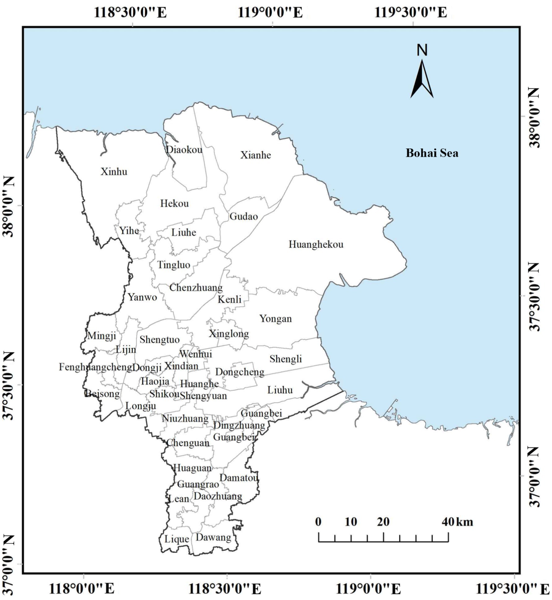
Figure 1. Location map of Dongying City.
2.2 Research methods
The potential for land consolidation in Dongying City is evaluated based on multiple land-use categories, including agricultural land, rural residential land, urban and industrial construction land, reserve land suitable for farming, and abandoned mine lands. Assessing and reclaiming these areas can simultaneously expand arable land resources and enhance ecological spaces such as forests and wetlands, thereby supporting both food security and ecological sustainability.
Arable land is a fundamental resource for agricultural production, and its quantity and quality are critical for ensuring national food security. In China, arable land consolidation serves as a central strategy for achieving a dynamic balance in the total amount of arable land, improving its quality, and enhancing ecological conditions.
A key methodological contribution of this study lies in its grid-based evaluation framework (Figure 2). Unlike conventional analyses that rely on administrative boundaries, the grid-based approach enables a more fine-grained, spatially continuous assessment of consolidation potential. This improves analytical precision by reducing aggregation bias, captures local heterogeneity in salinization and land-use conflicts more effectively, and enhances policy relevance by allowing flexible scaling—from township-level zoning to cross-county planning. By overcoming the limitations of administrative-unit analyses, this framework provides a more robust scientific basis for targeted interventions and adaptive governance in land consolidation.
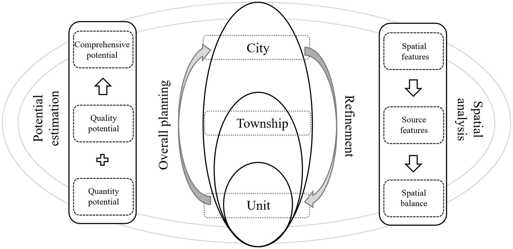
Figure 2. Basic logic for analyzing spatial characteristics of arable land consolidation potential.
2.2.1 Data sources and preprocessing
The basic datasets used in this study were obtained from the Dongying Municipal Bureau of Natural Resources and include: (i) the Third National Land Survey data (2019, vector format, minimum mapping unit of 0.2 ha for arable land and 0.5 ha for construction land); (ii) the Arable Land Quality Classification dataset (2016, 1,50,000 scale, evaluated using China’s Soil Quality Classification for Arable Land, GB/T 33469-2016); (iii) land use status maps (updated to 2020, 1:10,000 scale); and (iv) the Dongying Statistical Yearbooks (2018–2020), which provided grain yield and socio-economic indicators. All spatial datasets were projected into the unified CGCS2000 coordinate system and converted into both vector and raster formats (30 m resolution) suitable for grid-based analysis.
To ensure reliability, data cleaning involved removing duplicates, correcting topological errors, and aligning mismatched polygon boundaries. Land use categories were reclassified into arable land, rural residential land, construction land, facility agricultural land, ditches, and abandoned mine lands according to national land classification standards (MLR 2017). For grid analysis, the study area was divided into 2 km × 2 km and 10 km × 10 km grids, enabling both fine-scale precision and regional comparability.
Potential error sources include misclassification in survey data, temporal mismatches between different datasets (e.g., 2016 soil quality vs. 2019–2020 land use), and scale effects in aggregating from 30 m resolution to grid units. Based on national survey protocols, the overall accuracy of the Third National Land Survey exceeds 95%, but local deviations may still occur in areas with fragmented land use. These limitations were carefully considered when interpreting consolidation quantity and quality potentials, and results are presented as technically feasible estimates rather than guaranteed outcomes.
2.2.2 Clarification of grid scale selection
In this study, both 2 km × 2 km and 10 km × 10 km grids were employed to capture land use heterogeneity and to balance fine-scale precision with broader spatial comparability. The 2 km × 2 km grid provides a sufficiently detailed resolution to reflect the localized distribution of ditches, rural roads, and facility agricultural land, thereby ensuring accuracy in identifying small patches of land suitable for consolidation. At the same time, using 10 km × 10 km grids allows for the aggregation of data to a coarser scale that is more consistent with regional land use planning and policy decision frameworks. This dual-scale approach is particularly important for coastal saline regions like Dongying, where land use patterns exhibit strong spatial heterogeneity at fine scales, but consolidation policies are often formulated and implemented at broader administrative or planning units. By integrating results across these two scales, the study reduces the risk of scale bias, ensures comparability across regions, and provides a robust foundation for both micro-level land improvement practices and macro-level strategic planning.
2.2.3 Evaluation of arable land consolidation quantity potential
When determining the scale of arable land to be consolidated, several factors are considered: previously consolidated arable land, land designated for construction, ecological protection boundaries, urban development limits, high-standard basic farmland, and arable land within protected areas are excluded from the consolidation zones.
The potential for arable land consolidation arises from converting land previously used for facilities, rural roads, and ditches into arable land. Using data from the third national land survey, we calculate the non-arable land coefficient for 2 km*2 km grids within the consolidation areas. The minimum non-arable land coefficient within 10 km*10 km grids is determined as the coefficient for more intensive land use. For each 10 km*10 km grid, the new arable land coefficient is derived by subtracting the minimum non-arable land coefficient from the actual non-arable land coefficient of the 2 km*2 km grids. This new arable land coefficient is then used to estimate and aggregate the new arable land area for each township or district.
The city was divided into five potential levels: grids with a new arable land scale of ≥45 hectares were classified as high potential areas; grids with a new arable land scale of ≥24 hectares but <45 hectares were classified as upper-middle potential areas; grids with a new arable land scale of ≥12 hectares but <24 hectares were classified as middle potential areas; grids with a new arable land scale of ≥3 hectares but <12 hectares were classified as lower-middle potential areas; and grids with a new arable land scale of <3 hectares were classified as low potential areas.
The calculation formulas are as follows:
1. Non-arable land coefficient:
where:
Z is the non-arable land coefficient,
i is the grid number of the 2 km*2 km grid,
A is the area of ditches,
B is the area of facility agricultural land,
C is the area of rural roads,
D is the area of arable land,
E is the area of ditches,
F is the area of facility agricultural land,
G is the area of rural roads.
1. New arable land coefficient:
where:
Y is the new arable land coefficient,
r is the grid number of the 10 km*10 km grid,
Zri is the non-arable land coefficient in the 10 km*10 km grid r,
Zrimin is the minimum non-arable land coefficient in the 10 km*10 km grid r.
1. New arable land area:
where:
H is the new arable land area for the 2 km*2 km grid i,
D is the area of arable land,
E is the area of ditches,
F is the area of facility agricultural land,
G is the area of rural roads.
2.2.4 Evaluation of arable land consolidation quality potential
This study evaluates the quality potential of arable land consolidation based on the 2016 arable land quality classification results for Dongying City. Given that soil quality tends to be relatively stable in the short term, it is assumed that soil quality has remained constant since 2016. The highest quality classification of arable land within each 10 km*10 km grid is used as the benchmark for the potential quality that can be achieved through consolidation. The increase in arable land productivity within each 2 km*2 km grid is calculated based on elevating its quality classification to the highest standard. The potential increase in productivity is determined using average grain yields for different counties from the 2018 Dongying City Statistical Yearbook.
The city was divided into five quality potential levels: grids with a comprehensive quality potential of ≥1,500 tons were classified as high potential areas; grids with a potential of ≥850 tons but <1,500 tons were classified as upper-middle potential areas; grids with a potential of ≥450 tons but <850 tons were classified as middle potential areas; grids with a potential of ≥150 tons but <450 tons were classified as lower-middle potential areas; and grids with a potential of <150 tons were classified as low potential areas.
First, the average utilization classification Ri for each grid is calculated using a weighted sum. Since a lower classification number indicates higher quality, the quality potential for existing arable land consolidation in each grid is calculated using the following formula:
where:
• Qi1 is the quality potential for existing arable land consolidation in each 2 km*2 km grid (in tons),
• Rimin is the highest utilization classification in the 10 km*10 km grid,
• Wi is the area of existing arable land in each 2 km*2 km grid (in hm2),
• The 1.5 t/hm2 standard for grain yield is a level specified in China’s “Soil Quality Classification for Arable Land” (GB/T 33469-2016).
The total quality potential for arable land consolidation in each 2 km*2 km grid is calculated as:
where:
• Qi is the overall quality potential for arable land consolidation in each 2 km*2 km grid (in tons),
• Hi is the area of newly added arable land in the 2 km*2 km grid (in hm2),
• Fi is the average grain yield in the county where the 2 km*2 km grid is located (in t/hm2).
2.2.5 Comprehensive evaluation of arable land consolidation potential
Aggregate grid data on quantity and quality potential to town-level data. Use the natural breaks method to classify each town’s quantity and quality potential into categories, then assign scores (1–5) based on these classifications. Finally, sum the scores for both potentials to determine the overall arable land consolidation potential for each town.
To enhance methodological transparency, it is important to clarify the underlying assumptions and the scientific rationale of the parameter settings used in this study. First, the assumption of stable soil quality since 2016 is based on the generally slow-changing nature of soil fertility and classification benchmarks in the absence of major land use transformations; however, localized degradation or improvement may have occurred, which could cause deviations in potential estimates. Second, the use of the highest-quality classification within each 10 km × 10 km grid as the consolidation benchmark follows the principle of maximizing achievable potential, but it implicitly assumes that management and infrastructural inputs can fully eliminate intra-grid quality disparities—a condition that may not always hold in practice. Third, the adoption of a 1.5 t/hm2 grain yield standard is derived from China’s official “Soil Quality Classification for Arable Land” (GB/T 33469-2016), ensuring consistency with national policy and technical standards, yet this benchmark may underestimate or overestimate local productivity given the variability in saline–alkali soil responses. Similarly, county-level average grain yields from the 2018 Statistical Yearbook were used to estimate productivity improvements, which provides an empirically grounded but spatially aggregated parameterization that may obscure within-county heterogeneity. Finally, the classification thresholds for both quantity and quality potential were determined based on the distribution of local values and reference to existing literature on land consolidation potential evaluation, but different classification schemes might yield slightly different spatial patterns. Taken together, these assumptions and methodological choices ensure internal consistency and comparability with existing studies, while also highlighting the need for cautious interpretation of the results as technically feasible maxima rather than realized outcomes.
3 Results
3.1 Spatial distribution of arable land consolidation quantity potential
Based on the scale of newly reclaimed arable land, the coefficient frequency curve method was used in conjunction with cluster analysis to classify the potential levels for arable land consolidation. Based on the classification levels of grid potential, the data was aggregated at the township level. Using the natural breakpoint method, the townships were divided into zones. The types of land consolidation and the corresponding results are presented in Figure 3.
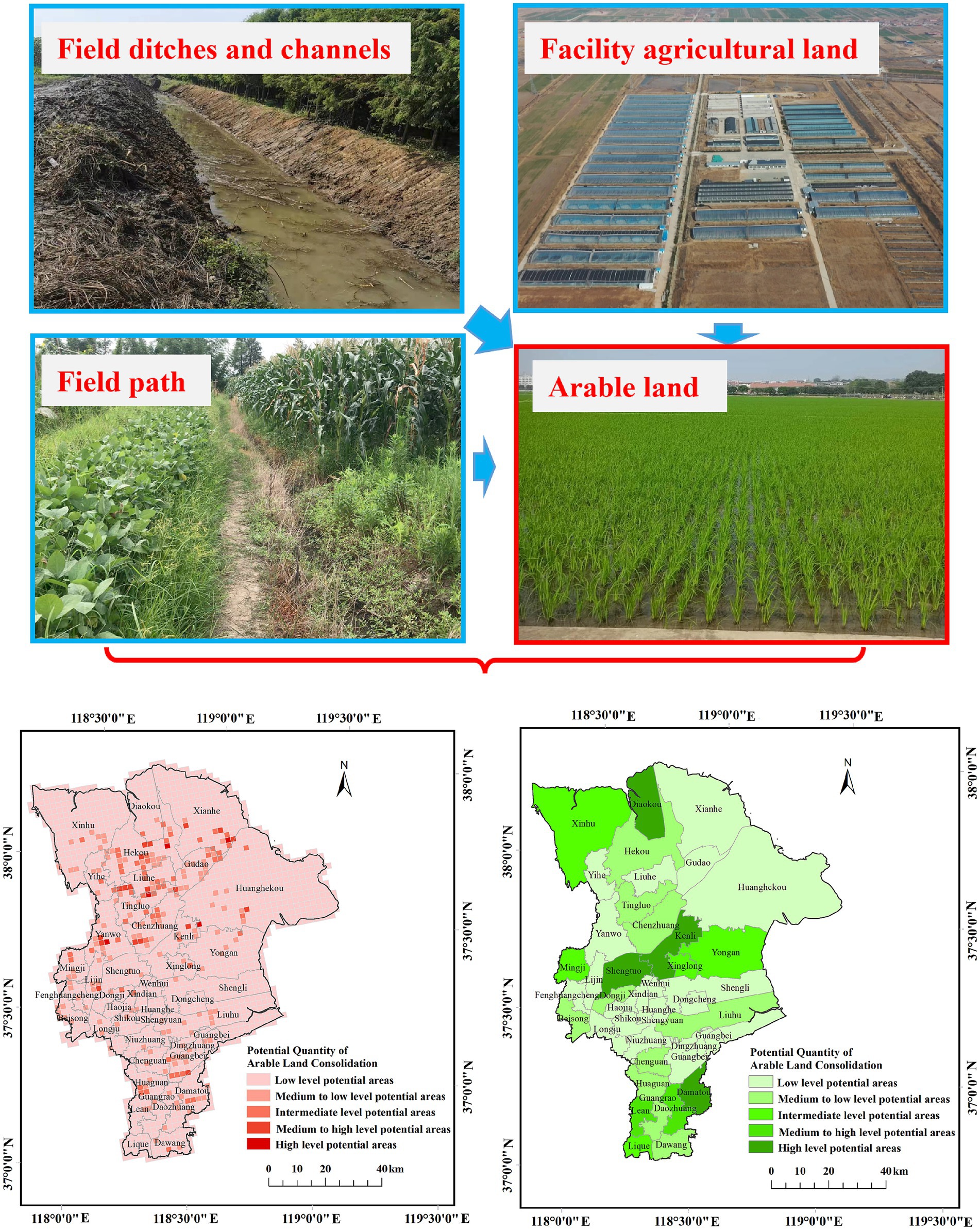
Figure 3. Distribution of arable land consolidation types and quantity potential in Dongying City.
The total potential for arable land consolidation in the city is 128703.88 hectares, with the potential to create an additional 2983.06 hectares of new arable land, resulting in a new arable land coefficient of 2.32%. The primary areas with arable land consolidation potential in Dongying City are concentrated in: Damatou Town, Le’an Street, Daozhuang Town, and Lique Town in Guangrao County; Shengtuo Town, Xinglong Street, Kenli Street, and Yong’an Town in Kenli District; and Diaokou Township and Mingji Township in Lijin County. For details, see Table 1.
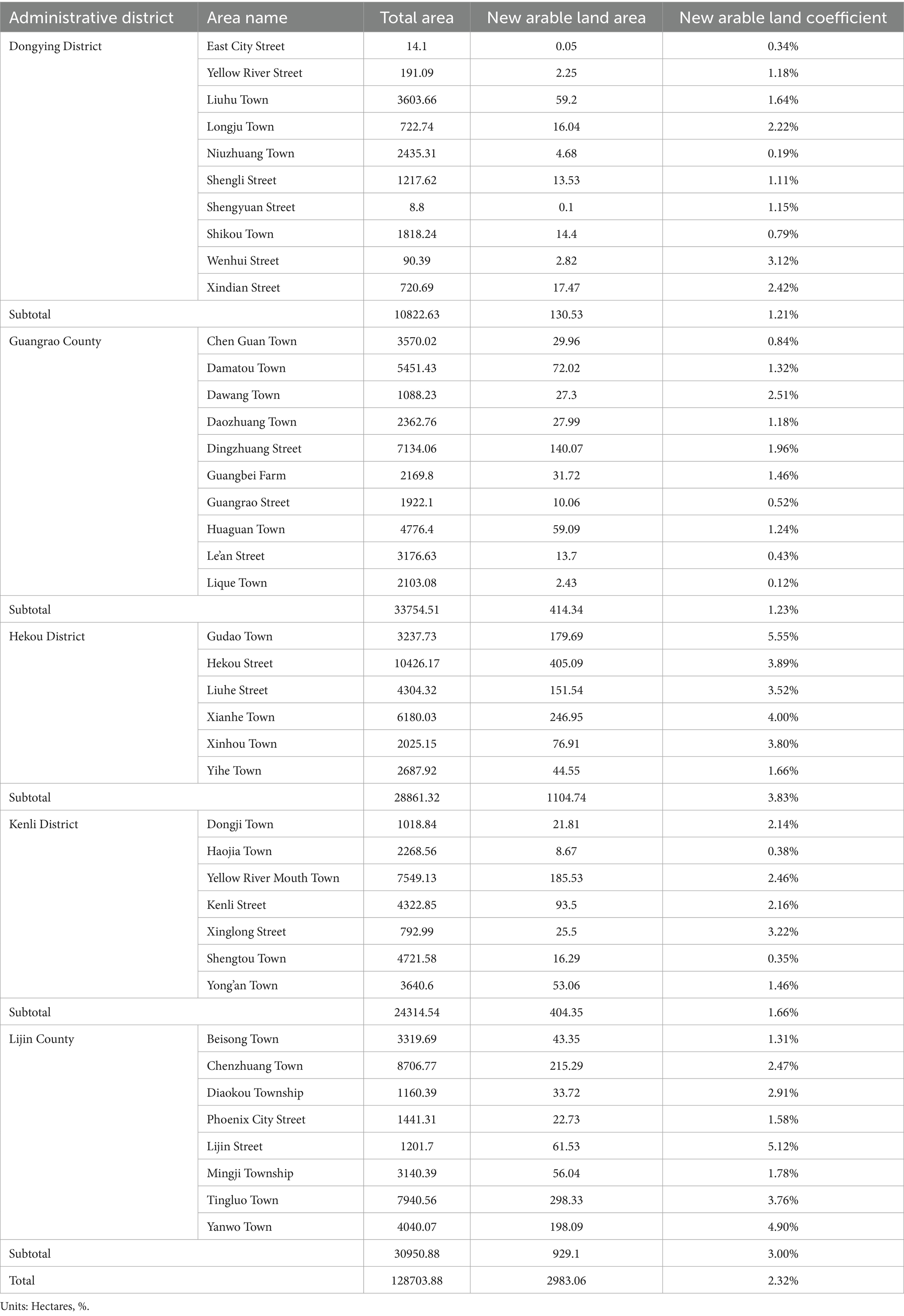
Table 1. Summary of arable land consolidation quantity potential in Dongying City.
This study employs the coefficient frequency curve method to evaluate the distribution frequency of new arable land and combines it with cluster analysis for classification. This approach effectively categorizes different potential levels and identifies areas with varying consolidation potential. Potential levels are defined based on the scale of new arable land, categorized from high to low into: high, upper-middle, middle, lower-middle, and low potential areas. This grading standard provides a clear, quantifiable basis for assessing the consolidation potential of different regions. The distribution indicates that areas such as Guangrao County, Kenli District, and Lijin County have higher consolidation potential and may therefore be prioritized for reclamation. This data aids in resource planning and policy development.
Dongying’s potential for arable land consolidation exhibits marked spatial heterogeneity. High and relatively high potential areas are primarily concentrated in several townships in the southern and south-eastern parts of the city, and some blocks along urbanization belts or facility-agriculture corridors also show elevated potential—likely due to the concentration of small fragmented plots, dispersed facility plots, or abandoned lands. Medium-potential areas are mainly distributed as scattered points or narrow belts that act as transitional zones between high- and low-potential patches. Low and relatively low potential areas are largely contiguous in the northeast and parts of the north-central region; these areas tend to have continuous or already scaled farmland with limited room for consolidation. In addition, some coastal saline-alkaline zones or areas constrained by natural conditions are classified as low potential because of severe salinization or high reclamation costs. The large differences in potential between neighboring townships reflect rapid short-distance changes in land-use types (e.g., facility agriculture, rural residential land, ditches, abandoned mines) and in plot fragmentation.
3.2 Spatial distribution of arable land consolidation quality potential
Based on the comprehensive quality potential for arable land consolidation, the coefficient frequency curve method was used alongside cluster analysis to classify the quality potential levels. Based on the classification levels of grid potential, the data was aggregated at the township level. Using the natural breakpoint method, the townships were divided into zones. The detailed results are illustrated in Figure 4.
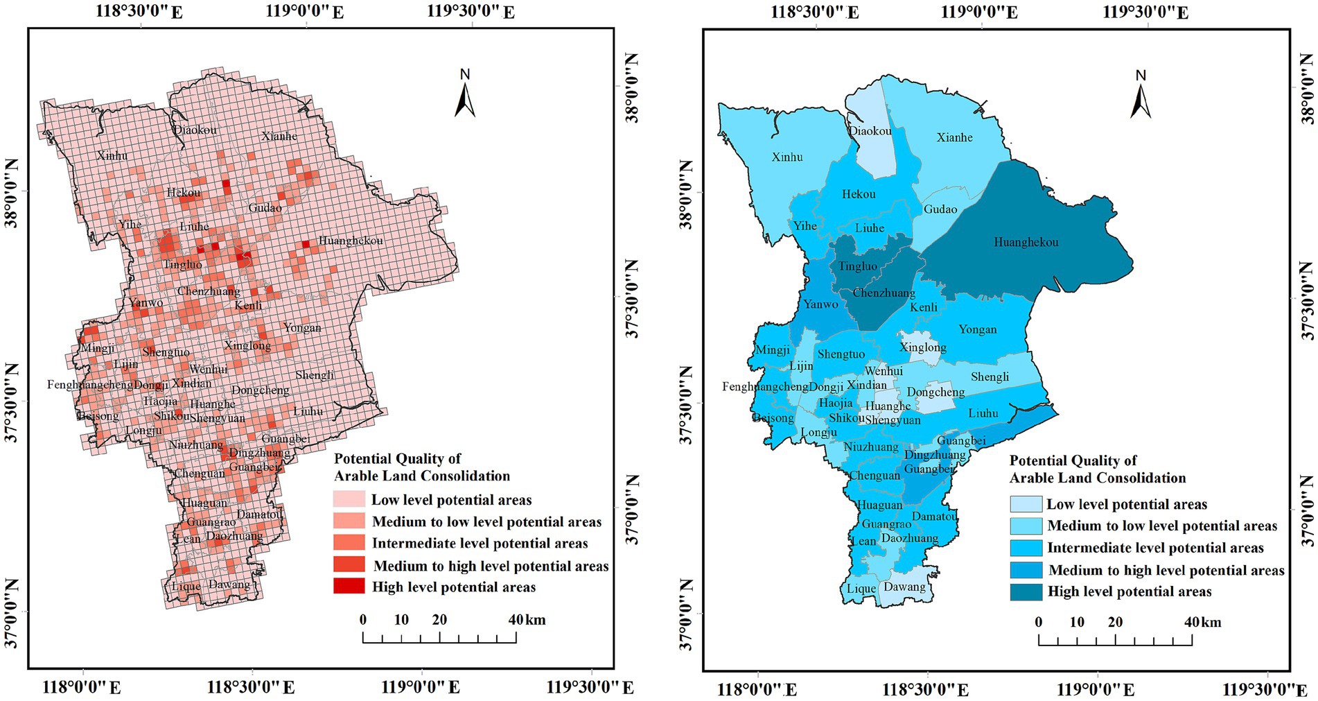
Figure 4. Distribution map of arable land consolidation quality potential in Dongying City.
According to the latest third survey results, the city’s comprehensive quality potential for arable land (grain yield consolidation capacity) is 425569.94 tons. Arable land consolidation potential in Dongying City is primarily concentrated in: Liuhu Town in Dongying District; Dingzhuang Street and Huaguan Town in Guangrao County; Yellow River Mouth Town, Shengtou Town, and Kenli Street in Kenli District; and Chen Zhuang Town, Tingluo Town, Yanwo Town, and Beisong Town in Lijin County. Details are provided in Table 2. The classification of specific areas highlights potential differences across the city’s districts and counties. This is crucial for formulating precise consolidation plans and allocating resources effectively. High-potential areas should be prioritized for consolidation, while low-potential areas might require less investment or deferred plans. The calculated comprehensive quality potential indicates significant overall room for consolidation in arable land. Detailed segmentation of these potentials allows for more precise policy-making and enhanced consolidation outcomes.
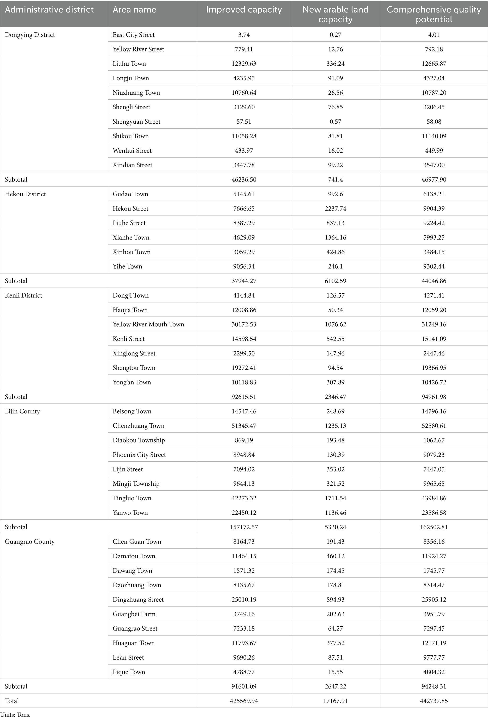
Table 2. Summary of arable land consolidation quality potential in Dongying City.
Dongying’s potential for improving arable land quality through consolidation shows pronounced spatial heterogeneity. High-potential areas are concentrated in several townships in the northeast and north, where the darkest blue patches (for example, near the Yellow River estuary and adjacent units) indicate substantial scope for quality improvement—likely due to underlying soil problems (e.g., remediable salinization) or abundant land types awaiting rehabilitation. Relatively high potential appears in some inland blocks and along urban fringe belts, represented by deep to medium-deep blue tones, likely driven by fragmented small plots or clusters of land heavily affected by human activities. Medium-potential zones occur as belts or scattered patches that link high- and low-potential areas, suggesting local parcels that can be improved through engineering or management interventions. Low and relatively low potential areas are mainly found in parts of the southern and southwestern jurisdiction, where contiguous light-blue zones imply inherently better soil quality or stable natural conditions, limited room or need for further improvement, or already completed remediation/scale-up that reduces marginal gains. Overall, sharp local contrasts between neighboring townships reflect rapid changes at short distances in land-use types, soil conditions, the distribution of facility agriculture, abandoned land, and ditch networks.
3.3 Spatial distribution of comprehensive arable land consolidation potential
Based on both the quantity and quality potentials for arable land consolidation, this study classified townships and streets into five potential levels. The process involved using the natural breaks method to categorize each township’s quantity and quality potentials, assigning scores accordingly. These scores were then summed to determine the comprehensive potential. Areas scoring 6–8 are classified as high potential zones, a score of 5 denotes upper-middle potential, 4 indicates middle potential, 3 represents lower-middle potential, and 2 signifies low potential. The results are detailed in Table 3 and illustrated in Figure 5.
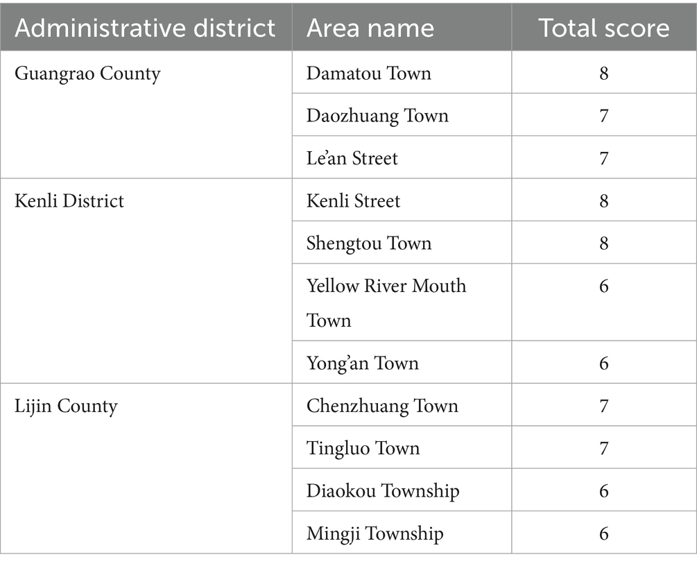
Table 3. High potential zones for arable land consolidation in Dongying City.
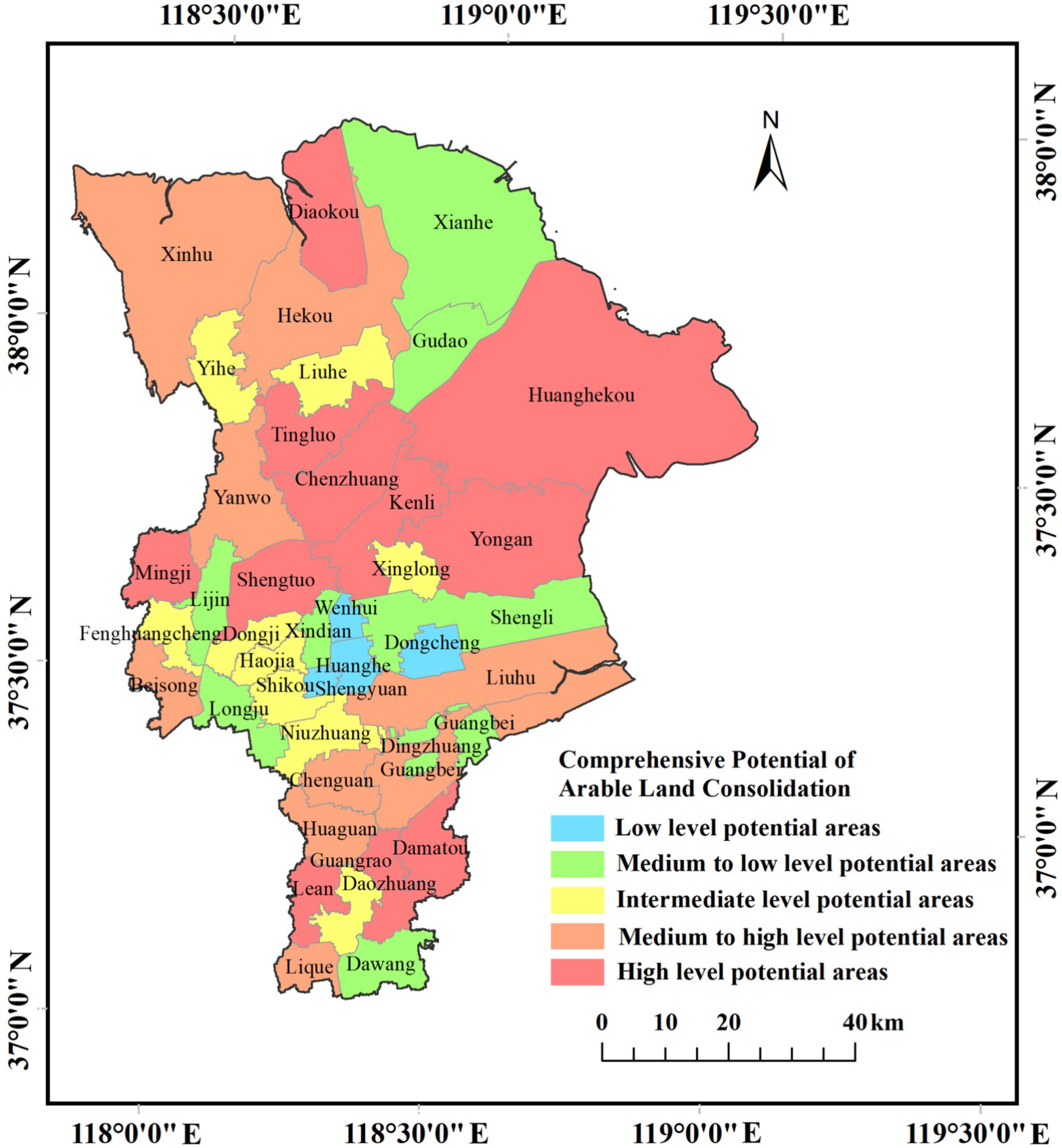
Figure 5. Arable land consolidation potential zones in Dongying City.
From the Figure 5, it is evident that the key high-potential areas for arable land consolidation are primarily located in the central and northern regions of Dongying City. These areas are expected to become focal points for future arable land consolidation efforts to maximize their effectiveness. In contrast, the southern part of Dongying City, including some townships and streets, exhibits relatively lower potential for arable land consolidation and may only require moderate intervention. Resource allocation in these areas will need to be managed carefully to balance effectiveness with efficient use of resources. Dongying District, overall, has the smallest potential for arable land consolidation, with limited supplementary arable land resources available. Any consolidation activities in this area should be minimal and contingent upon favorable conditions.
The use of the natural breaks method and comprehensive scoring approach ensures a scientifically sound and rational division of arable land consolidation zones. The natural breaks method avoids the subjectivity of manually set boundary points, while the comprehensive scoring provides a more holistic assessment of potential. Tailored consolidation strategies are proposed for different potential zones, offering clear guidance for future work. High-potential areas are prioritized for consolidation, while low-potential areas are addressed with moderate efforts as conditions permit. This approach and its results provide valuable guidance for arable land consolidation initiatives, aiding decision-makers in formulating effective strategies and enhancing land use efficiency.
4 Discussion
4.1 Spatial heterogeneity and governance implications
This study reveals pronounced spatial clustering in the potential for arable-land consolidation across Dongying City. High-value towns and townships are concentrated in the central-northern portion of the city—for example, Damatou, Daozhuang, Lean, Kenli Subdistrict, and Shengtuo—ranking among the top in both quantity and quality potential. For instance, Chenzhuang Town in Lijin County exhibits a quality potential exceeding 34,000 tonnes, while Hekou District contains 1104.74 hectares of newly available arable land. By contrast, most townships in Dongying District show relatively low potential, with less than 300 hectares of new area and quality potential below the city average. The north–south gradient in potential reflects not only differences in natural land endowments and infrastructure provision, but also uneven institutional and policy conditions within the municipality.
From a governance perspective, spatial heterogeneity provides a theoretical basis for differentiated policies. Arable-land consolidation exhibits path dependence and investment externalities: once drainage systems, field reorganization and soil improvement are implemented in a given area, neighboring towns can reap spillover benefits at lower marginal cost. For example, in the border zone between Lijin and Kenli, prioritizing infrastructure investment in high-potential patches would allow surrounding townships to share drainage networks and mechanization services. This approach could reduce unit investment costs by an estimated 15–20%. By contrast, a spatially uniform rollout would disperse funds and human resources and likely deliver lower overall returns than expected. Therefore, governance should respond to spatial clustering by prioritizing high-potential areas to exploit increasing returns to scale.
International experience corroborates this governance logic. In Punjab, India, research found that concentrating irrigation infrastructure delivered an 18% improvement in irrigation efficiency compared with dispersed layouts (Bhatia and Singh, 2024). In the Ethiopian highlands, FAO projects (FAO, 2020) demonstrate that prioritizing intensive cultivation in high-potential zones can produce broader food-security gains under constrained fiscal budgets. Conversely, in some African countries, efforts to pursue spatially even land governance without accounting for spatial heterogeneity have yielded per-capita yield gains of less than 5% and significantly lower investment returns than the global average (Ji et al., 2023). These lessons suggest that Dongying should adopt a “concentrated breakthrough—diffusion-driven” approach in regional governance rather than pursuing uniform, evenly distributed interventions.
Based on the identified spatial heterogeneity, differentiated promotion strategies should be adopted for different potential zones. For high and relatively high potential areas (priority advancement), demonstration-oriented land consolidation and large-scale improvement projects should be carried out, combined with land transfer, the merging of farming units, and efficiency-oriented intensification. Infrastructure upgrading in irrigation, rural roads, electricity, and mechanization services should be accompanied by fiscal subsidies and technical support to lower integration costs. In peri-urban areas, clear mechanisms for land-use conversion and compensation are needed to encourage homestead concentration and the transition of facility agriculture toward intensive development. For medium potential areas (steady advancement), fine-grained and classified integration strategies should be applied, focusing on eliminating fragmented obstacles within contiguous farmland (e.g., ditches, scattered road segments) and coordinating with farmland water conservancy projects. Cooperative organizations, land trusteeship, and land transfer platforms should be mobilized to attract social capital and optimize the structure of operating entities. For low and relatively low potential areas (protection and optimization), emphasis should be placed on safeguarding high-quality contiguous farmland and maintaining basic grain production capacity, while avoiding unnecessary forced consolidation. For saline–alkali land, wetlands, or ecologically sensitive areas, cautious improvement should be prioritized, and where costs or ecological trade-offs are too high, ecological restoration or “returning farmland to wetlands” should take precedence. Cross-regional and institutional measures should include a multi-scalar planning framework that integrates plot–township–county–municipal levels, embedding consolidation outcomes into regional development and industrial planning to minimize duplication and conflict. Differentiated fiscal and technical support mechanisms should provide key subsidies for high-input and high-potential zones. At the same time, digital land management (grid-based parcel databases, remote sensing/GIS monitoring) should be enhanced to improve decision-making accuracy and oversight efficiency, while refining land transfer, homestead withdrawal, and compensation systems to protect farmers’ interests and strengthen their willingness to participate.
4.2 Decoupling between quantity and quality potentials and policy implications
Our analysis reveals a clear spatial decoupling between quantity potential and quality potential for arable-land consolidation in Dongying. For example, Hekou District offers 1104.74 ha of newly available arable land (about 37% of the city’s total area potential), yet its quality potential is only 44046.86 tonnes—only slightly above the city average. By contrast, Lijin County, with a smaller new-area potential of 929.10 ha, accounts for the city’s highest quality potential at 162502.81 tonnes (38% share). Guangrao and Kenli also show relatively high quality potentials (roughly 94,000–95,000 tonnes) despite having only 404–414 ha of newly available land.
This pattern indicates that different constraints govern the two dimensions of potential. Areas with large quantity potential are mainly limited by soil salinization and hydraulic conditions. In contrast, areas with high quality potential are constrained by the degree of farm intensification and the current level of production technology.
The policy implication is that interventions must be place-sensitive rather than one-size-fits-all. In zones with high quantity but limited quality potential, priority should be given to foundational works such as drainage, salt leaching and land leveling. For instance, if Hekou were to reduce soil salinity below 0.4% through drainage and amelioration measures, theoretical productivity could increase by more than 30%. Conversely, in areas with high quality potential but limited new area—such as Chenzhuang and Dingluo—policy should emphasize intensification: consolidated management, precision inputs and the dissemination of salt-tolerant varieties. For example, promoting the salt-tolerant rice cultivar “Dongdao-5” could raise yields by about 8–10% at the same input level.
The observed decoupling between consolidation quantity and quality potentials arises from the interplay of natural, infrastructural, and institutional factors. First, natural resource endowment determines the basic trade-off: coastal saline–alkali soils in Dongying can provide large tracts of newly reclaimed land once drainage and leveling are implemented, but their intrinsic fertility and organic matter levels remain low, limiting quality gains even after consolidation. Second, historical land-use legacies and infrastructure distribution shape divergent trajectories. Areas with long-established irrigation networks, soil amelioration projects, and relatively stable farming systems can achieve substantial improvements in quality without much scope for further expansion, while areas previously underutilized or degraded may expand rapidly in area but struggle to close the productivity gap. Third, institutional zoning and policy regimes reinforce the decoupling: ecological redlines, high-standard farmland designations, and restrictions on construction land conversion often reduce the space for quantity expansion in regions with better soils, channeling resources instead toward technological upgrading and intensification. Finally, socioeconomic dynamics such as land transfer markets and cooperative organization affect the feasibility of quality-oriented improvements. In regions with fragmented tenure and weak collective action, even large tracts of reclaimed land may not translate into significant productivity gains due to inefficiencies in scale management.
International evidence shows similar quantity–quality decoupling. In the Netherlands, northern regions with limited new land have achieved 20–25% increases in yield per hectare through efficient intensification and precision fertilization (van der Veer et al., 2024). By contrast, some Indian states that expanded arable area extensively did not concomitantly improve soil fertility, so actual yield gains on newly brought-into-production land reached less than 60% of their theoretical potential (Birthal et al., 2021). These lessons suggest that Dongying should align resources and policy instruments with regional endowments to convert spatial potentials into realized productive capacity efficiently.
4.3 From potential diagnosis to prioritization: methodology and policy instruments
We developed a composite scoring system that integrates quantity and quality potentials to produce a scientifically grounded prioritization scheme. Primary priority zones (scores 6–8), such as Damatou, Kenli Subdistrict and Chenzhuang, combine substantial available new area with high capacity-increase potential and should receive concentrated fiscal support and policy resources. These areas are suitable for rapid implementation of combined engineering and agronomic packages to accelerate the conversion of potential into productive capacity. Secondary zones (scores 4–5), for example some townships in Guangrao, are appropriate for a “pilot first, scale later” approach to contain costs and manage risks. Tertiary zones (scores 2–3), mainly clustered in Dongying District, should be spared large-scale investment and instead prioritized for ecological functions or risk-buffering measures.
On methods, our approach synthesizes coefficient-frequency curves, cluster analysis and Jenks natural breaks classification to balance spatial precision with the administrative operability of township governance units. Classifying at the township level improves practical manageability of budget allocation, engineering contracting and supervision. Nevertheless, the modifiable areal unit problem (MAUP) remains a potential source of sensitivity: for example, raising the “high quality potential” threshold from 45,000 t to 50,000 t could change the rank positions of 3–4 townships. International studies report similar scale sensitivities; for instance, research on land consolidation in the U. S. Midwest shows that different grid sizes and administrative delineations materially affect the identification of priority areas (Birthal et al., 2021).
Accordingly, future work should strengthen prioritization robustness through sensitivity testing, multi-scenario simulation and threshold perturbation analysis, thereby increasing the reliability and transferability of priority maps and related policy recommendations.
4.4 Adaptive pathways under saline-alkali conditions and outlook
The natural conditions of coastal saline-alkali zones determine both the complexity and dynamism of arable-land consolidation. Dongying’s total assessed potential amounts to 2983.06 ha of newly available arable land and 425569.94 tonnes of quality potential; the new area is concentrated in Hekou District, while quality gains are mainly located in Lijin, Kenli and Guangrao. Policy emphasis in Hekou should therefore be placed on drainage and salt-leaching systems: lowering the groundwater table to about 1.2–1.5 m and reducing soil salinity by 20–30% are necessary to ensure that newly reclaimed land is converted into sustainable productive capacity. Areas with concentrated quality potential, such as Lijin and Kenli, should prioritize deployment of salt-tolerant cultivars, integrated nutrient management and mechanization; for example, adopting salt-tolerant rice varieties could raise yields by some 8–10% at the same input level.
In low-potential townships (for instance, parts of Dongying District), the marginal value of ecosystem services and social benefits may exceed that of additional food output. Measures such as wetland conservation, buffer-strip construction and on-farm water storage can indirectly support regional food security while maintaining ecological function. International evidence from coastal saline regions in the Netherlands and Israel shows that promoting salt-tolerant crops combined with precision irrigation can boost yields by roughly 15–20% in land-limited settings (Kan and Rapaport-Rom, 2012; Zhang et al., 2024).
Despite the promising technical pathways, several barriers may constrain effective implementation. First, high upfront investment costs for large-scale drainage, desalination, and mechanization infrastructure often exceed the fiscal capacity of county-level governments, especially under tight budgetary conditions. Second, institutional fragmentation between agricultural, water conservancy, and ecological protection departments can lead to overlapping responsibilities and inconsistent policy signals, weakening coordination in project design and execution. Third, farmer participation and adoption willingness remain uncertain: smallholders may be reluctant to engage in land transfer or adopt salt tolerant cultivars due to perceived risks, insufficient subsidies, or lack of technical support. Fourth, market and value-chain limitations reduce incentives for cultivating saline-tolerant crops, as stable procurement channels and price premiums are not yet fully developed. Finally, environmental uncertainties—including fluctuating groundwater levels and increasing climate variability—may compromise the long-term effectiveness of engineering-based reclamation. Addressing these obstacles requires not only differentiated technical measures but also supportive institutional reforms, financial mechanisms, and farmer-oriented incentive schemes to ensure that consolidation potentials can be translated into durable productivity gains.
It should be emphasized that the potentials estimated here are technically feasible maxima; their realization depends on fiscal capacity, governance quality and farmers’ willingness to adopt new practices, and coastal environments are highly dynamic. Future research should integrate socioeconomic variables and climate-change scenarios to develop a dynamic decision-support system that strengthens the foresight and adaptability of policy interventions.
5 Conclusions and management implications
This study used a gridded assessment framework to systematically identify the quantity potential, quality potential and their combined spatial patterns for arable-land consolidation in the coastal saline-alkali areas of Dongying. It further explored differentiated governance pathways and policy optimization options. The results show that potential for arable-land improvement exhibits significant complexity and regional variation in spatial distribution, the relationship between quantity and quality, and preferred reclamation pathways. These findings provide empirical support for accurately identifying high-potential zones and allocating reclamation resources, and they offer guidance for subsequent policy design, zonal governance and international benchmarking. Based on the analysis, we summarize the key conclusions and derive practical management recommendations.
5.1 Major findings
5.1.1 Significant spatial heterogeneity in consolidation potential
Overall, consolidation potential in Dongying displays a north-center-high to south-low pattern. High-potential areas are concentrated in parts of Guangrao County (e.g., Damatou, Daozhuang, Lean), Kenli District (e.g., Shengtuo, Kenli Subdistrict) and Lijin County (e.g., Chenzhuang, Dingluo, Yanwo), while most townships in Dongying District show relatively low potential. This spatial clustering indicates strong scale effects and externalities in consolidation benefits.
5.1.2 Decoupling between quantity potential and quality potential
Hekou District has the largest new-area potential (1104.74 ha) but only limited per-unit capacity gains, whereas Lijin County, with a smaller new area (929.10 ha), contributes the city’s highest quality potential (162502.81 t, 38% of the total). This pattern suggests that quantity potential is primarily constrained by soil salinization and hydraulic conditions, while quality potential depends more on farming intensity and the adoption of production technologies.
5.1.3 Prioritization from the integrated assessment indicates zonal governance directions
Based on combined quantity–quality scores, three gradients emerge: high-priority areas (e.g., Damatou, Kenli Subdistrict, Chenzhuang) should receive front-loaded resource allocation; medium-priority areas are suitable for “pilot first, then scale up” approaches; low-priority areas should focus on ecological protection and risk buffering rather than large-scale investment.
5.1.4 Saline-alkali conditions determine differentiated remediation pathways
Newly available land is concentrated in heavily saline Hekou, where priority must be given to salt-removal and core infrastructure works. By contrast, areas like Lijin, Guangrao and Kenli should concentrate on yield enhancement through salt-tolerant varieties, precision fertilization and mechanization integration.
5.2 Management implications
5.2.1 Adopt place-based, differentiated consolidation strategies
In high-quantity potential zones such as Hekou District, priority should be given to foundational engineering measures already emphasized in Dongying’s ongoing saline–alkali land consolidation projects, including subsurface drainage, soil amelioration, and land leveling. In high-quality potential zones like Lijin and Kenli, governance should focus on integrated management—promoting salt-tolerant crop varieties listed in Shandong’s Saline-Alkali Tolerant Cultivar Catalogue, alongside balanced fertilization and mechanized operations. These differentiated approaches align with the Shandong Province Saline-Alkali Land Utilization Plan (2021–2030), which stresses zoning-based remediation pathways.
5.2.2 Concentrate investments to realize economies of scale
Building on Dongying’s “high-standard farmland construction” program, investment should be concentrated in high-potential townships to expand drainage networks and field restructuring projects. This can create spillover effects across adjacent areas, reducing per-unit costs and improving overall efficiency, consistent with the fiscal allocation principles set in Shandong’s provincial consolidation initiatives.
5.2.3 Build a tiered policy support system
Policy implementation should follow the logic of phased promotion. For high-priority zones, increased fiscal transfers and technical services (e.g., subsidies for salt-tolerant rice and wheat) can accelerate consolidation outcomes. For medium-priority zones, pilot demonstration projects should be emphasized, with gradual scaling up as performance evidence accumulates. For low-priority zones, Dongying’s ecological protection policies should guide the shift toward wetland conservation, water regulation, and ecological restoration, ensuring that land consolidation contributes not only to food security but also to the goals of the Yellow River Delta Ecological Protection Strategy.
5.2.4 Increase the adaptability and dynamism of planning
Since the calculated potentials represent technical maxima, their realization depends on fiscal capacity, governance quality, and farmer adoption. Integrating scenario simulations into Dongying’s Territorial Spatial Master Plan can enhance policy foresight. In particular, coupling saline–alkali remediation plans with climate adaptation measures (e.g., sea-level rise, extreme precipitation) will strengthen resilience in policy execution.
5.2.5 Strengthen international learning while localizing applications
Coastal saline regions such as the Netherlands and Israel demonstrate that salt-tolerant cultivars and precision irrigation can raise yields by 15–20%. However, failures in India illustrate the risks of neglecting soil amelioration. Dongying should localize these lessons by scaling up salt-tolerant rice varieties (e.g., “Dongdao” series tested in the Yellow River Delta) and precision water–salt regulation, while embedding them within existing governance frameworks to ensure effective implementation.
5.3 Future research directions
While this study provides a comprehensive assessment of consolidation potential and governance strategies in coastal saline–alkali regions, further research is needed to capture the dynamic nature of land systems. Future work should incorporate dynamic simulations that integrate climate change scenarios, sea-level rise risks, and socio-economic drivers such as urban expansion, agricultural market shifts, and rural labor mobility. Coupling these drivers with system dynamics and agent-based models will enable a deeper understanding of trade-offs between food security, ecological resilience, and socio-economic sustainability. Such approaches will not only refine the accuracy of potential assessments but also strengthen the foresight capacity of land consolidation planning under conditions of uncertainty.
Data availability statement
The original contributions presented in the study are included in the article/supplementary material, further inquiries can be directed to the corresponding author.
Author contributions
YL: Data curation, Investigation, Methodology, Writing – original draft. RY: Investigation, Methodology, Supervision, Validation, Writing – original draft. TH: Conceptualization, Investigation, Resources, Writing – review & editing.
Funding
The author(s) declare that financial support was received for the research and/or publication of this article. This work was supported by the National Natural Science Foundation of China (42301230), the China Postdoctoral Science Foundation (2022M723234), the University-Industry Collaborative Education Program of the Ministry of Education of China (241105095122024), Nanjing Tech University 2025 University-Level Teaching Reform Research Project (20250035), 2025 Jiangsu Province Higher Education Informatization Research Project (2025JSETKT123), 2025 Project of the Safety Education Committee of the Chinese Society for Educational Development Strategy (AQJY20251010), Nanjing Tech University 2025 Special Research and Practice Innovation Project on Party Conduct and Clean Government Construction in the New Era of Higher Education Institutions (LZ20250219).
Conflict of interest
The authors declare that the research was conducted in the absence of any commercial or financial relationships that could be construed as a potential conflict of interest.
Generative AI statement
The authors declare that no Gen AI was used in the creation of this manuscript.
Any alternative text (alt text) provided alongside figures in this article has been generated by Frontiers with the support of artificial intelligence and reasonable efforts have been made to ensure accuracy, including review by the authors wherever possible. If you identify any issues, please contact us.
Publisher’s note
All claims expressed in this article are solely those of the authors and do not necessarily represent those of their affiliated organizations, or those of the publisher, the editors and the reviewers. Any product that may be evaluated in this article, or claim that may be made by its manufacturer, is not guaranteed or endorsed by the publisher.
References
Bhatia, S., and Singh, S. P. (2024). Assessing groundwater use efficiency and productivity across Punjab agriculture: district and farm size perspectives. Agriculture 14:1299. doi: 10.3390/agriculture14081299
Birthal, P. S., Hazrana, J., Negi, D. S., and Bhan, S. C. (2021). Climate change and land-use in Indian agriculture. Land Use Policy 109:105652. doi: 10.1016/j.landusepol.2021.105652
Cassaway, A. F., Twilley, R. R., Rovai, A. S., and Snedden, G. A. (2024). Patterns of marsh surface accretion rates along salinity and hydroperiod gradients between active and inactive coastal deltaic floodplains. Estuar. Coast. Shelf Sci. 301:108757. doi: 10.1016/j.ecss.2024.108757
Causapé, J., Gimeno, M. J., and Auqué, L. (2023). Hydrosaline balance evolution of an irrigated zone: the case of Lerma basin (Spain, 2004–2020). Sci. Total Environ. 905:166996. doi: 10.1016/j.scitotenv.2023.166996
Falcon, W. P., Naylor, R. L., and Shankar, N. D. (2022). Rethinking global food demand for 2050. Popul. Dev. Rev. 48, 921–957. doi: 10.1111/padr.12508
Farinós-Celdrán, P., Robledano-Aymerich, F., Carreño, M. F., and Martínez-López, J. (2017). Spatiotemporal assessment of littoral waterbirds for establishing ecological indicators of Mediterranean coastal lagoons. ISPRS Int. J. Geo Inf. 6:256. doi: 10.3390/ijgi6080256
Fayet, C. M. J., Reilly, K. H., Van Ham, C., and Verburg, P. H. (2022). What is the future of abandoned agricultural lands? A systematic review of alternative trajectories in Europe. Land Use Policy 112:105833. doi: 10.1016/j.landusepol.2021.105833
Feng, S., Lakshmanan, P., Zhang, Y., Zhang, T., Liang, T., Zhang, W., et al. (2023). A comprehensive continental-scale analysis of carbon footprint of food production: comparing continents around the world. J. Clean. Prod. 426:138939. doi: 10.1016/j.jclepro.2023.138939
Ji, X., Su, P., Liu, Y., Wu, G., and Wu, X. (2023). Mutual complementarity of arable land use in the Sino-Africa trade: evidence from the global supply chain. Land Use Policy 128:106588. doi: 10.1016/j.landusepol.2023.106588
Kan, I., and Rapaport-Rom, M. (2012). Regional blending of fresh and saline irrigation water: is it efficient? Water Resour. Res. 48:7517. doi: 10.1029/2011WR011285
Khan, A., Ezati, P., and Rhim, J. W. (2023). Alizarin: prospects and sustainability for food safety and quality monitoring applications. Colloids Surf. B Biointerfaces 223:113169. doi: 10.1016/j.colsurfb.2023.113169
Kimsanova, B., Sanaev, G., and Herzfeld, T. (2024). Dynamics of food demand during political instability: evidence from Kyrgyzstan. Agric. Econ. 55, 41–53. doi: 10.1111/agec.12810
Liu, Y., Dai, L., and Long, H. (2023). Theories and practices of comprehensive land consolidation in promoting multifunctional land use. Habitat Int. 142:102964. doi: 10.1016/j.habitatint.2023.102964
Liu, S., Gao, Y., Lu, P., Sun, Y., and Liu, X. (2024). Arable land in Northwest China: dynamics analysis of health and productivity in 2000-2020. Land Degrad. Dev. 35, 2226–2242. doi: 10.1002/ldr.5056
Liu, C., Song, C., Ye, S., Cheng, F., Zhang, L., and Li, C. (2023). Estimate provincial-level effectiveness of the arable land requisition-compensation balance policy in mainland China in the last 20 years. Land Use Policy 131:106733. doi: 10.1016/j.landusepol.2023.106733
Liu, S., Xiao, W., Ye, Y., He, T., and Luo, H. (2023). Rural residential land expansion and its impacts on cultivated land in China between 1990 and 2020. Land Use Policy 132:106816. doi: 10.1016/j.landusepol.2023.106816
Lu, D., Wang, Z., Su, K., Zhou, Y., Li, X., and Lin, A. (2024). Understanding the impact of cultivated land-use changes on China’s grain production potential and policy implications: a perspective of non-agriculturalization, non-grainization, and marginalization. J. Clean. Prod. 436:140647. doi: 10.1016/j.jclepro.2024.140647
Meyfroidt, P., de Bremond, A., Ryan, C. M., Archer, E., Aspinall, R., Chhabra, A., et al. (2022). Ten facts about land systems for sustainability. Proc. Natl. Acad. Sci. USA 119:e2109217118. doi: 10.1073/pnas.2109217118
Mmbando, G. S. (2023). Recent advances in antibiotic-free markers; novel technologies to enhance safe human food production in the world. Mol. Biotechnol. 65, 1011–1022. doi: 10.1007/s12033-022-00609-7
Nath, K. G., Pandiselvam, R., and Sunil, C. K. (2023). High-pressure processing: effect on textural properties of food- a review. J. Food Eng. 351:111521. doi: 10.1016/j.jfoodeng.2023.111521
Nunoo, I., Boansi, D., and Owusu, V. (2023). Does the use of cocoa farmlands for artisanal small-scale gold mining really increase household food insecurity? Evidence from Ghana. Resour. Policy 87:104329. doi: 10.1016/j.resourpol.2023.104329
Ostrom, E. (2009). A general framework for analyzing sustainability of social-ecological systems. Science 325, 419–422. doi: 10.1126/science.1172133
Pravalie, R., Borrelli, P., Panagos, P., Ballabio, C., Lugato, E., Chappell, A., et al. (2024). A unifying modelling of multiple land degradation pathways in Europe. Nat. Commun. 15:3862. doi: 10.1038/s41467-024-48252-x
Rao, J. (2022). Comprehensive land consolidation as a development policy for rural vitalisation: rural in situ urbanisation through semi socio-economic restructuring in Huai town. J. Rural. Stud. 93, 386–397. doi: 10.1016/j.jrurstud.2020.09.009
Ringrose, S., Cassidy, L., Diskin, S., Coetzee, S., Matheson, W., Mackay, A. W., et al. (2014). Diagenetic transformations and silcrete-calcrete intergrade duricrust formation in palaeo-estuary sediments. Earth Surf. Process. Landforms 39, 1167–1187. doi: 10.1002/esp.3516
Ritzel, C., Mack, G., and Fiankor, D. D. (2024). The long-term effect of COVID-19 policy stringency on consumer food demand quantities in Switzerland. J. Agric. Food Res. 16:101119. doi: 10.1016/j.jafr.2024.101119
Sun, X., Xiang, P., and Cong, K. (2023). Research on early warning and control measures for arable land resource security. Land Use Policy 128:106601. doi: 10.1016/j.landusepol.2023.106601
Tom-Dery, D., Aduwa, S. A., Boadu, K. O., Amponsah, A., Nasare, L. I., Owusu-Prempeh, N., et al. (2023). Effects of commercial farming on livelihoods and woody species in the Mion district, Ghana. J. Agric. Food Res. 13:100637. doi: 10.1016/j.jafr.2023.100637
van der Veer, S., Hamed, R., Karabiyik, H., and Roskam, J. L. (2024). Mitigating the effects of extreme weather on crop yields: insights from farm management strategies in the Netherlands. Environ. Res. Lett. 19:104042. doi: 10.1088/1748-9326/ad7308
van Dijk, M., Morley, T., Rau, M. L., and Saghai, Y. (2021). A meta-analysis of projected global food demand and population at risk of hunger for the period 2010-2050. Nat. Food 2, 494–501. doi: 10.1038/s43016-021-00322-9
Verburg, P. H., Crossman, N., Ellis, E. C., Heinimann, A., Hostert, P., Mertz, O., et al. (2015). Land system science and sustainable development of the earth system: a global land project perspective. Anthropocene 12, 29–41. doi: 10.1016/j.ancene.2015.09.004
Wang, H., Zhou, W., Ma, R., Wang, J., and Zhang, H. (2024). Is marginalised cultivated land on the Tibetan plateau suitable for production or ecology? An example from the northeastern Tibetan plateau. Land Degrad. Dev. 35, 1818–1836. doi: 10.1002/ldr.5023
Wei, H., Wang, Y., Liu, J., Zhang, J., and Cao, Y. (2023). Coordinated development of cultivated land use and ecological protection in cities along the main stream of the Yellow River in Henan Province, China. Ecol. Indic. 156:111143. doi: 10.1016/j.ecolind.2023.111143
Xu, W., Jin, X., Liu, J., Li, H., Zhang, X., and Zhou, Y. (2023). Spatiotemporal evolution and the detection of key drivers in the resilience of cultivated land system in major grain-producing regions of China. Land Degrad. Dev. 34, 4712–4727. doi: 10.1002/ldr.4804
Yang, R., Xu, S., Gu, B., He, T., Zhang, H., Fang, K., et al. (2024). Stabilizing unstable cropland towards win-win sustainable development goals. Environ. Impact Assess. Rev. 105:107395. doi: 10.1016/j.eiar.2023.107395
Ye, S., Ren, S., Song, C., Cheng, C., Shen, S., Yang, J., et al. (2022). Spatial patterns of county-level arable land productive-capacity and its coordination with land-use intensity in mainland China. Agric. Ecosyst. Environ. 326:107757. doi: 10.1016/j.agee.2021.107757
Ye, S., Ren, S., Song, C., Du, Z., Wang, K., Du, B., et al. (2024). Spatial pattern of cultivated land fragmentation in mainland China: characteristics, dominant factors, and countermeasures. Land Use Policy 139:107070. doi: 10.1016/j.landusepol.2024.107070
Yuan, X., Shao, Y., Li, Y., Liu, Y., Wang, Y., Wei, X., et al. (2022). Cultivated land quality improvement to promote revitalization of sandy rural areas along the Great Wall in northern Shaanxi Province, China. J. Rural. Stud. 93, 367–374. doi: 10.1016/j.jrurstud.2019.10.011
Zhang, Y., Lei, M., Lan, X., Zhang, X., Fan, S., and Gao, J. (2024). The multiple effects of farmland infrastructure investment on agrifood systems in China—an interdisciplinary model analysis. China Agric. Econ. Rev. 16, 320–339. doi: 10.1108/CAER-08-2023-0209
Zhang, H., Wang, Y., Liu, L., Zhou, J., Wan, Q., Chen, J., et al. (2024). Bibliometric analysis of contemporary research on the amelioration of saline soils. Agronomy 14:2935. doi: 10.3390/agronomy14122935
Zhang, T., Zhang, F., Li, J., Xie, Z., and Chang, Y. (2024). Unraveling patterns, causes, and nature-based remediation strategy for non-grain production on farmland in hilly regions. Environ. Res. 252:118982. doi: 10.1016/j.envres.2024.118982
Zheng, L. (2024). Big hands holding small hands: the role of new agricultural operating entities in farmland abandonment. Food Policy 123:102605. doi: 10.1016/j.foodpol.2024.102605
Keywords: arable land, consolidation potential, grid method, spatial characteristics, Dongying City
Citation: Lin Y, Ye R and Hu T (2025) Grid-based assessment of comprehensive arable land consolidation potential in coastal saline regions: a case study of Dongying, China. Front. Sustain. Food Syst. 9:1690116. doi: 10.3389/fsufs.2025.1690116
Edited by:
Weiwei Zheng, Northwest A&F University, ChinaReviewed by:
Kunyu Liang, Nanjing University of Aeronautics and Astronautics, ChinaLinfei Yu, Institute of Geographic Sciences and Natural Resources Research, China
Copyright © 2025 Lin, Ye and Hu. This is an open-access article distributed under the terms of the Creative Commons Attribution License (CC BY). The use, distribution or reproduction in other forums is permitted, provided the original author(s) and the copyright owner(s) are credited and that the original publication in this journal is cited, in accordance with accepted academic practice. No use, distribution or reproduction is permitted which does not comply with these terms.
*Correspondence: Tunan Hu, dHVuYW5oQHllYWgubmV0