 Francesco Finazzi
- Department of Management, Information and Production Engineering, University of Bergamo, Bergamo, Italy
Earthquake Network is a citizen science research project implementing an earthquake early warning system based on smartphone crowdsourcing. People join the project by installing a smartphone application and they receive real time alerts when earthquakes are detected by the smartphone network. Started at the end of 2012, the project has involved more than 5.5 million people and the application currently has around 500,000 active users. This makes Earthquake Network one of the largest citizen science project and an earthquake early warning system operational at the global scale. This paper aims at describing the main features of the project, of the smartphone application and of the data which are made available when an earthquake is detected in real time or reported by the application users.
1. Introduction
Earthquake Early Warning (EEW) systems are timidly becoming operational in some areas of some seismic countries (Cremen and Galasso, 2020). Despite EEW technology is mature, liability issues about who send the alerts and who is responsible for false/missed detections limit the pace at which EEW are made available to the general public. Additional, the high implementation and operation costs are an obstacle for the diffusion of EEW systems in underdeveloped and developing countries.
In parallel to EEW systems run by government agencies at the national level, the last decade has witnessed the development of “unofficial” platforms providing fast earthquake alerts at the global level. This was possible thanks to smartphone technology and to the crowdsourcing model, with people making their smartphone available in order to receive a useful service in return. Well-known examples are the LastQuake project (Bossu et al., 2018) by the European-Mediterranean Seismological Centre and the MyShake project (Kong et al., 2016) by the UC Berkeley Seismological Laboratory. For LastQuake, a smartphone application (app hereafter) is used to monitor people activity soon after an earthquake. If many people from the same area open the app at the same time, it is likely that an earthquake has just occurred and an alert is sent. For MyShake, a smartphone app is used to continuously monitor the smartphone accelerometer in order to measure earthquakes and possibly send alerts.
This paper is about the Earthquake Network project (Finazzi, 2016) that, despite it has been on the scene long before LastQuake and MyShake, it has only recently gain the attention of the seismological community. As the other two projects, Earthquake Network has its own smartphone app which is used for earthquake detection. In its functioning, the Earthquake Network app is similar to the MyShake app, with the exception that it does not try to make any seismological analysis of the data recorded by the accelerometer and early warnings are issued when many smartphones from the same area detect accelerations above a threshold.
Earthquake Network, however, is more than just EEW and this paper comprehensively describes for the first time all the features of the Earthquake Network platform and of the Earthquake Network app.
2. History of the Project
The Earthquake Network app was first published on the Android Market (now known as Google Play) on 20 December 2012. At that time, the app was only available in Italian and it was designed to work with Android version 2.3.3. With an average of 50 installs per day, it took the network around 5 months to reach the critical mass for detection. The first detection took place in Italy on 8 May 2013 at 00:52:33 UTC. According to the EMSC catalog (ID 315886), a M3.6 earthquake occurred at 00:52:17 UTC with a depth of 8 km. The earthquake was detected by 4 smartphones located at 23 km from the epicenter and an alert was immediately sent to people with the app installed. This was the evidence that smartphones can actually detect earthquakes and this is when the Earthquake Network project officially started.
Since then, more than 5.5 million participants took part to the project, a number higher than the 5.2 million participants of the famous SETI@home project (Anderson et al., 2002) searching for signs of extraterrestrial intelligence since 1999.
Table 1 shows the distribution by country of the 3,130 alerts issued as of 26 May 2020. Note that the first and last alert dates are quite heterogeneous among countries. This is due, on the one hand, on the local seismicity varying with time, and on the other, on the app being installed by the population at different stages of the project life. Usually, people install the app after a strong earthquake hits their area, and the network of smartphones grows up to the point it is able to detect aftershocks and future earthquakes. Similarly, people may loose interest in the project and uninstall the app in periods of “seismic calm,” actually jeopardizing future detections in the area. For instance, Nepal had enough users to detect 6 earthquakes in real time in 2015 but it currently only has 150 users with the app installed and new detections are unlikely. The same problem affected Japan and Taiwan for which the two detections are related to aftershocks after large earthquakes. Mainly because the app is not translated into the local languages, however, the smartphone network did not last long.
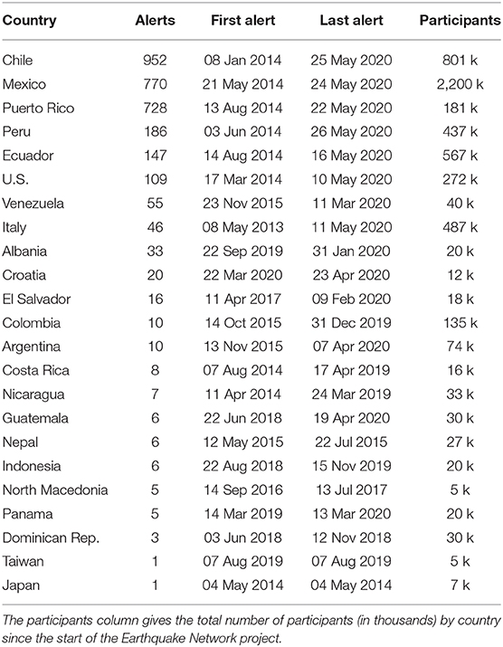
Table 1. Geographical and temporal distribution of the 3,130 alerts sent by the Earthquake Network platform since 2013.
3. Smartphone App
The Earthquake Network app is both the instrument to detect an earthquake and to receive the early warning. When the smartphone is charging and unused, the app starts monitoring the accelerometer for detecting vibrations possibly due to an earthquake. If something is detected, a signal is sent to a server that collects signals from all the smartphones. Thanks to a statistical algorithm, the server decides in real time if an earthquake is occurring. If this is the case, an alert is sent to the smartphone users around the epicenter, which may be received before the user experience the shaking.
Earthquake Network, therefore, provides an early warning service to users which are keen to make their smartphones available for detection when the smartphone is not used. On the other hand, the impact of the app on the user daily experience with her/his smartphone is practically zero, nor the app has any impact on battery consumption unless the user interacts with the app.
Figure 1 shows the warning message appearing on the smartphone when the alert is received. If the lead time is greater than zero, a count down and a simulation of the expected location of the P-phase front are displayed.
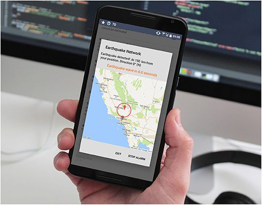
Figure 1. Early warning message as received on smartphones with the Earthquake Network app installed.
4. Warning System
The smartphone network sends signals to a server located in Europe for real time detection of earthquakes. The infrastructure is actually based on a total of nine servers which cope with the large number of signals coming from the network and the large number of users opening the app when an earthquake strikes.
Any new signal received by the server infrastructure triggers a statistical algorithm that decides if an earthquake is happening. The analysis is thus in real time and at the global scale. This implies that multiple earthquakes occurring at different places of the world can all be detected at the same time and separate warnings are issued.
4.1. Statistical Algorithm
On average, only one trigger out of a million is due to an earthquake and adopting a statistical algorithm is the only way to reduce and control the probability of false alarm. Although the algorithm is detailed in Finazzi and Fassò (2017), it is worth describing here the general idea behind its functioning.
The algorithm is based on statistical hypothesis testing which is a statistical inference method for choosing between two hypothesis, one called null hypothesis and the other called alternative hypothesis. The null hypothesis usually describes a favorable condition and, as long as it is true, no action is required. The null hypothesis is thus supposed to be true unless there is enough evidence to reject it in favor of the alternative hypothesis, and evidence is brought by the data.
In this context, the null hypothesis is that no earthquakes are undergoing while the alternative hypothesis is that an earthquake is currently happening and an alert must be sent. Data used for accepting or rejecting the null hypothesis are the triggers send by the smartphones and the number of active smartphones in a given area.
The rule for rejecting the null hypothesis is defined by studying the statistical distribution of the smartphone triggers when no earthquakes are happening. Due to human interaction, smartphones send triggers also when the ground is not actually shaking and the statistical distribution of the number of triggers has a natural variability that mainly depends on the number of active smartphones. Defining the rejecting rule essentially means to set a threshold on the number of triggers, above which an earthquake is claimed. Currently, the minimum value for the threshold is five, meaning that at least six smartphones must be active in the area affected by the shaking and that all of them must send a trigger at around the same time. Below this value, the smartphone network is not reliable. Also note that having six active smartphones does not imply that, in case of an earthquake, six triggers will be received by the server. Smartphones are not seismometers and, for a large number of reasons, they may not send the trigger even if affected by the shaking. This implies that six is a critical mass for detection but also that it is not guaranteed that the detection will occur.
4.2. False Alarms and Missed Detections
When the statistical algorithm is running, two kinds of errors can be made. An earthquake is detected but nothing is happening (false alarm) or the earthquake is happening but the null hypothesis is not rejected (missed detection). There is a trade-off between the probability of false alarm and the probability of missing a detection. Decreasing the former implies to increase the latter and vice-versa.
The choice made by Earthquake Network is to control the probability of false alarm and to fix it at the desired value. Currently, the algorithm is designed to have a nominal false alarm rate of one false alarm per year per country. In practice, this probability is often exceeded due to events which, for the smartphone network, are indistinguishable from an earthquake. These event include explosions, strong thunders, sonic boom and, more rarely, soccer fans celebrating a goal 1.
The probability of missing an earthquake, instead, cannot be easily controlled. While the probability of false alarm is controlled by studying the behavior of the network when no earthquakes are occurring (namely most of the time), the probability of missing an earthquake can only be studied by simulating the response of the smartphone network during that particular earthquake. The response of the network is affected by the spatial distribution of the shaking level, the number of active smartphones, the spatial distribution of the smartphones, the smartphone sensor sensitivity and many other factors which are specific to a given earthquake at a given time.
What is observed is that, when the earthquake epicenter is close to a town with enough smartphones with the app installed, the network is able to detect earthquakes down to magnitude 2. On the other hand, strong earthquakes with epicenter far from any town may not be detected, despite they are mildly felt in different towns. This behavior of the network is currently under investigation.
Additionally, the probability of missing an earthquake is affected by the number of active smartphones at the time of the event. This probability reaches its minimum at around 3 AM when many smartphones are charging while it is maximum at around 2 p.m. Nonetheless, this probability tends to zero when the number of active smartphones increases. When the minimum number of active smartphones, within a town and during the day, is a above 500, the time of day does not matter anymore.
4.3. Alert Distribution
When an earthquake is detected, the server infrastructure sends the alert to smartphones located in the expected affected area. This is done using the Firebase Cloud Messaging (FCM) messaging platform which allows to send notifications to a large number of smartphones in near real time. The current alert strategy of Earthquake Network is based on the distance between the preliminary epicenter and the smartphones, where the preliminary epicenter is simply the center of gravity of the locations of smartphones that contributed to detect the earthquake.
Smartphones close to the epicenter are thus alerted first. This strategy is not necessarily optimal since smartphones very close to the epicenter cannot be alerted before the shaking and priority should go on smartphones with a lead time greater than zero. Nonetheless, the actual epicenter may be far from the preliminary estimate and the distance-based criterion is the “safest” option under this uncertainty condition.
By default, smartphones receive the alert if located within 300 km from the epicenter but users can change this setting at any time from the app configuration page.
5. User Felt Reports
By simply pushing a button in the app interface, users can report the impact of an earthquake they just felt. Spatial coordinates of the smartphone are automatically sent with the felt report. Contrary to a questionnaire, the app is designed in such a way that the report is sent as fast as possible to the server and the app interface (see Figure 3) only allows for three levels of impact: mild (only perceived), strong (fall of objects), and very strong (building collapse).
If many reports are received from the same area at around the same time, a notification is sent to the smartphone users using FCM. In general, users first receive the early warning alert triggered by smartphones and within one minute they receive the notification triggered by users. By clicking on the notification, the user is redirected to a map showing all felt reports. As an example, Figure 2 depicts the reports collected in Puerto Rico within 60 s after a 3.6 magnitude earthquake. Before any official information was released, app users were aware that the impact of the earthquake was negligible. In general, this kind of information may be useful for civil protection agencies and first responders in order to identify areas where the earthquake had the highest impact on people and things.
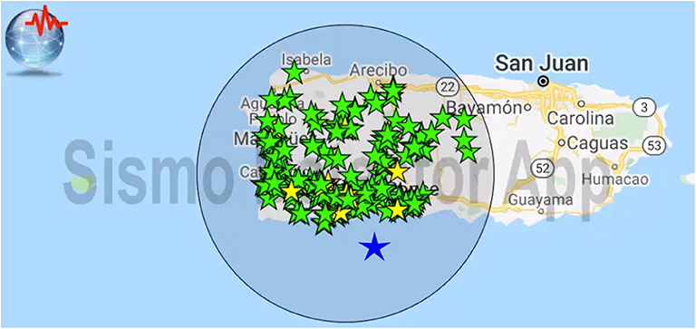
Figure 2. Felt reports sent by users of the Earthquake Network app after a 3.6 magnitude earthquake in Puerto Rico on 26 January 2020, 01:59:26 UTC (EMSC catalog ID 823242) within 60 s from origin time. Blue star is the earthquake epicenter. Green (mild) and yellow (strong) stars are felt reports localized using smartphone spatial coordinates.
Additionally, reports collected in the first few seconds/minutes after the earthquake are useful for providing preliminary estimates of earthquake parameters such as magnitude and depth. Finazzi (2020) shows how a space-time statistical model is trained to provide estimates of the above parameters, uncertainty included, and to update those estimates while new felt report are collected by the server. The statistical model accounts for an information content of the felt reports which increases with time and for the heterogeneity in the people's response across the globe. It is usually the case that people living in low seismicity countries tend to report a strong earthquake despite it is small in magnitude and despite the actual impact is not the one selected through the app user interface.
6. Social Network
Earthquake Network is also the first social network about earthquakes. With chatrooms in 10 languages, users can share information soon after an earthquake, either in the public space or with private messages. In the public space, order is maintained by chat moderators whose role is to keep the discussion focused on important matters and to block users who behave against the rules. Although secondary with respect to the mission of Earthquake Network, chatrooms actually help people during what can be a shocking experience and, according to their comments, having someone to discuss with is useful to reduce anxiety and the fear of new earthquakes. Moreover, users who join the chatrooms are those who keep the app installed for longer periods, from months to years. User retention is a common problem of citizen science projects and encouraging interaction with the app and other users may increase the user lifetime value.
Earthquake Network is also on popular social networks such as Facebook2, with nearly 90 k people engaged, and Twitter3, with around 82 k followers. When an early warning is issued or users report an earthquake, information are published in real time on Facebook and Twitter in order to reach people without the app installed and who will likely join the project.
7. Search and Rescue Aid
When a strong earthquake hit and causes extensive damage, smartphone technology can be helpful in search and rescue operations allowing missing people to be localized. Earthquake Network is currently testing two strategies for helping localize missing people, one based on statistical modeling of people location and one based on the smartphone geolocation capabilities. Both strategies assume that people and smartphone are located in the same place, which is usually the case.
7.1. Statistical Model of People Location
The Earthquake Network app periodically sends the smartphone location to the server. This information is exploited, on the one hand, for earthquake detection, and on the other, to first alert people close to the epicenter when an earthquake is detected.
Considering all the locations sent by a smartphone during an extended period, a statistical model (Finazzi and Paci, 2019) can be trained to learn the spatio-temporal pattern of the user location along a typical week. Indeed, people tend to exhibit cyclical patterns and to be in the same place at a given time of a given day of the week. If a person is missing after a strong earthquake, the statistical model can provide the expected location(s), uncertainty included, at the time of the earthquake.
7.2. Real Time Geolocation
The second strategy implemented by the Earthquake Network app is to send the smartphone coordinates by e-mail or SMS to a list of trusted contacts when an alert is received. The idea is that, even in the case of catastrophic earthquakes, the alert is received before the shaking starts and the e-mail/SMS is sent before Internet and/or the phone network are compromised. This solution is more appealing since the uncertainty on the user location is usually much lower if compared with the previous strategy. However, it requires the smartphone to be on at the time of the earthquake.
After the e-mail/SMS is sent, users can update their status by sending a “I'm fine” or “I need help” message to the same contacts. This is done by simply pressing a button in the user interface of the app. The right panel of Figure 3 shows the user interface for sending messages to contacts and an example of message which is sent by pressing the “I need help” button. Users can opt-in and opt-out this service at any time from the app configuration page, where e-mail addresses and phone numbers of the trusted contacts are also set.
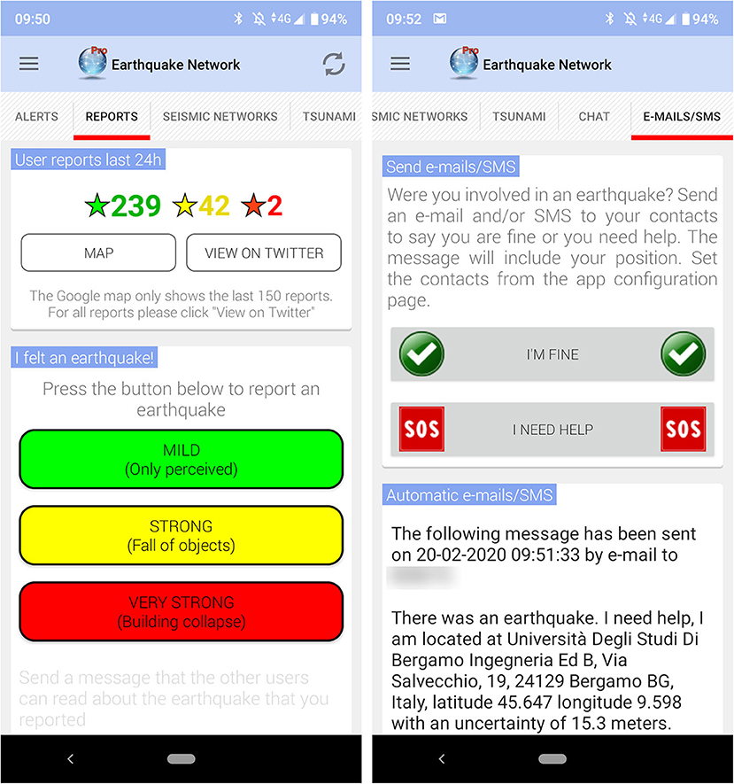
Figure 3. User interface of the Earthquake Network app for sending felt reports (Left) and for asking help if involved in an earthquake (Right).
8. Implementation and Operational Costs
Assessing the implementation costs of an EEW system developed over more than seven years is not an easy task. Nonetheless, the magnitude of some costs can be provided.
Assuming to know all system specifications, developing an app similar to Earthquake Network (for Android and iOS) costs around 40,000 Euros. Implementing the server architecture (hosted by an Internet provider) for the real time detection and able to handle up to one million active users costs around 50,000 Euros. Operational costs, on the other hand, are relatively small. Assuming that the system is stable and does not need major updates, average operational costs are around 250 Euros/month and no human intervention is needed. Currently, these costs are covered by in-app advertising, meaning that the Earthquake Network project is self-sustainable.
Finally, scaling the EEW system requires around 2,000 Euros per million active users. However, smartphone technology may not be the most efficient option for distributing a real time alert to a very large number of people and this cost is meaningful only up to 10 million users globally.
9. User Privacy
Collecting and handling user locations opens some privacy issues. Despite this information is collected anonymously, the user must have a way to delete all personal data (chat messages included) stored on the server. Earthquake Network is compliant with the General Data Protection Regulation on data protection and privacy in the European Union and the European Economic Area. This means that Earthquake Network has a data protection officer who is responsible for handling and deleting personal data upon user request.
10. Open Problems and Conclusions
Earthquake Network is widely appreciated in many seismic countries where EEW systems are not available or not yet operational. Despite it releases very preliminary information, it helps to rapidly fulfill the need for information arising among the population soon after an earthquake.
Current main limit of the EEW system implemented by Earthquake Network is that the warning is sent without an accurate information of the earthquake intensity. This means that warnings may also be triggered by mild earthquakes that do not require a warning to be sent. As a consequence, some users may receive the warning but not experiencing any shaking. Although the smartphone is measuring an acceleration, the smartphone acceleration is not easily related to the ground acceleration. Indeed, the smartphone is an object with a relatively small mass that is free to move. Especially during a strong earthquake, the recorded acceleration may be much higher than the ground acceleration. Also, in general, the recorded acceleration may depend on unknown factors such as the object above which the smartphone is located, the floor within the building and so on.
Another intrinsic limit of Earthquake Network is that smartphones are located where people are and the geometry of the network is not necessarily optimized with respect to the known faults. Therefore, it may be useful to integrate the smartphone network data with measurements coming from seismometers.
Thanks to TURNkey4 and RISE5 projects financed by the Horizon 2020 programme of the European Commission, Earthquake Network will see improvements both on the real time detection side and on the real time integration of data coming from classing seismic networks. In particular, a statistical approach will be adopted to explore acceleration-free methods for estimating and updating the earthquake intensity/magnitude in near real time, completing the information provided to the population through the Earthquake Network app and through social networks.
Data Availability Statement
The datasets generated for this study are available on request to the corresponding author.
Author Contributions
The author confirms being the sole contributor of this work and has approved it for publication.
Funding
Toward more Earthquake-resilient Urban Societies through a Multi-sensor-based Information System enabling Earthquake Forecasting, Early Warning, and Rapid Response actions TURNkey project has received funding from the European Union's Horizon 2020 research and innovation programme under grant agreement No 821046. Real-time Earthquake Risk Reduction for a Resilient Europe RISE project has received funding from the European Union's Horizon 2020 research and innovation programme under grant agreement No 821115.
Conflict of Interest
The author declares that the research was conducted in the absence of any commercial or financial relationships that could be construed as a potential conflict of interest.
Acknowledgments
The author is thankful to two reviewers for very helpful comments that improved the quality of this paper and to Steamware S.R.L. for the great job in designing and implementing the hardware architecture of Earthquake Network.
Supplementary Material
The Supplementary Material for this article can be found online at: https://www.frontiersin.org/articles/10.3389/feart.2020.00243/full#supplementary-material
Footnotes
1. ^https://www.foxnews.com/tech/soccer-fans-in-peru-celebrate-crucial-goal-trigger-earthquake-alert-app
2. ^https://www.facebook.com/earthquakenetwork
3. ^https://twitter.com/SismoDetector
References
Anderson, D. P., Cobb, J., Korpela, E., Lebofsky, M., and Werthimer, D. (2002). SETI@home: an experiment in public-resource computing. Commun. ACM 45, 56–61. doi: 10.1145/581571.581573
Bossu, R., Roussel, F., Fallou, L., Landès, M., Steed, R., Mazet-Roux, G., et al. (2018). Lastquake: from rapid information to global seismic risk reduction. Int. J. Disast. Risk Reduct. 28, 32–42. doi: 10.1016/j.ijdrr.2018.02.024
Cremen, G., and Galasso, C. (2020). Earthquake early warning: recent advances and perspectives. Earth Sci. Rev. 2020:103184. doi: 10.1016/j.earscirev.2020.103184
Finazzi, F. (2016). The earthquake network project: toward a crowdsourced smartphone-based earthquake early warning system. Bull. Seismol. Soc. Am. 106, 1088–1099. doi: 10.1785/0120150354
Finazzi, F. (2020). Fulfilling the information need after an earthquake: statistical modelling of citizen science seismic reports for predicting earthquake parameters in near realtime. J. R. Stat. Soc. Ser. A. doi: 10.1111/rssa.12577. [Epub ahead of print].
Finazzi, F., and Fassò, A. (2017). A statistical approach to crowdsourced smartphone-based earthquake early warning systems. Stochast. Environ. Res. Risk Assess. 31, 1649–1658. doi: 10.1007/s00477-016-1240-8
Finazzi, F., and Paci, L. (2019). Kernel-based estimation of individual location densities from smartphone data. Stat. Model. doi: 10.1177/1471082X17870331. [Epub ahead of print].
Keywords: smartphone network, crowdsourcing, citizen science, real time alerts, statistics
Citation: Finazzi F (2020) The Earthquake Network Project: A Platform for Earthquake Early Warning, Rapid Impact Assessment, and Search and Rescue. Front. Earth Sci. 8:243. doi: 10.3389/feart.2020.00243
Received: 24 February 2020; Accepted: 04 June 2020;
Published: 14 July 2020.
Edited by:
Remy Bossu, European-Mediterranean Seismological Centre, FranceReviewed by:
Jennifer A. Strauss, University of California, Berkeley, United StatesIna Cecic, Slovenian Environment Agency, Slovenia
Copyright © 2020 Finazzi. This is an open-access article distributed under the terms of the Creative Commons Attribution License (CC BY). The use, distribution or reproduction in other forums is permitted, provided the original author(s) and the copyright owner(s) are credited and that the original publication in this journal is cited, in accordance with accepted academic practice. No use, distribution or reproduction is permitted which does not comply with these terms.
*Correspondence: Francesco Finazzi, ZnJhbmNlc2NvLmZpbmF6emlAdW5pYmcuaXQ=