 Giancarlo Neri
 Barbara Orecchio
 Silvia Scolaro
 Cristina Totaro
- Department of Mathematical and Computer Science, Physical Sciences and Earth Sciences, University of Messina, Messina, Italy
We analyze the seismicity of southern Calabria, the most active area of Italy from the seismic point of view, and compare it with geodetic data available from literature. Our analysis focuses both on the strongest earthquakes of the last centuries reported in the Italian historical seismic catalog and on seismicity recorded in the last decades by instrumental networks. The data highlight that strong shallow seismicity of southern Calabria, imputed to normal faulting by previous investigators, corresponds to low values of local, geodetic horizontal strain rate. This situation is quite different from that observed along the Apennines from central Italy to northern Calabria, where normal-faulting strong earthquake activity corresponds to relatively large values of extensional strain rate. On the other hand, the strong earthquake activity of southern Calabria corresponds to marked variation of vertical displacement rates detected from west to east in the same area. We frame these evidences into the regional geodynamic model assuming the coexistence of Africa-Europe NNW-trending plate convergence and SE-ward residual rollback of the Ionian lithospheric slab subducting underneath the Tyrrhenian-Calabria unit. Taking also benefit from the recently found relationship between the two strongest earthquakes of the 20th century in Italy (the southern Calabria earthquakes of 1905 and 1908 of magnitude 7.5 and 7.1, respectively), we propose that instabilities of the upper bending part of the subduction slab may perturb shallow normal faults in the overriding plate and concur to shallow seismicity of southern Calabria jointly with the dynamics of differential vertical motion marked by geodetic data. The opposite action of lithosphere convergence and rollback may justify low values of horizontal strain rate in the low coupling scenario of the Ionian and Tyrrhenian-Calabria units.
Introduction
In the last decade, taking benefit from large improvement of geophysical datasets and methods, researchers have much deepened the knowledge of the structure and dynamics of the Calabrian Arc subduction zone (Figures 1 and 2), the most active area of Italy from the seismic point of view. Neri et al. (2009, 2012) have found that southern Calabria is the only place in the Calabrian Arc subduction zone where the subduction slab is still continuous over depth, while detachment of the deepest portion of subducting lithosphere has already occurred beneath the Arc edges (northern Calabria and northeastern Sicily, respectively; Figure 1). Other investigators (see, e.g., Presti et al., 2013; Totaro et al., 2016) have distinguished the main compressional domain west of Calabrian Arc due to NNW-trending Africa-Europe plate convergence from the subduction domain where plate convergence and gravity-induced rollback of the Ionian subducting slab coexist (Figure 1). Joint analyses of geophysical and geologic data collected in the wide offshore sectors of the subduction zone have led Polonia et al. (2016, 2017) to identify an incipient rifting process at the southwestern edge of the Ionian subducting slab. A 3D reconstruction of the interface between the subducting and the overriding plates beneath southern Calabria has been performed by Maesano et al. (2017) who have also debated whether this subduction interface may be locked or not. On their hand, Carafa et al. (2017) have suggested high interseismic coupling with low seismic coupling on the subduction interface, assuming that elastic strain accumulating on the interface is released episodically in creep events. The dynamics of plate interaction at the subduction interface remains a major topic of debate in the study region. Finally, Presti et al. (2017, 2019) have focused on the dynamics of the Ionian subducting slab and proposed a revision of the traditional view of down-dip compression throughout the whole slab. In particular, Presti et al. (2019) stated that the upper part of the descending slab (located above a necking zone detected at 150 km depth) is subjected to down-dip extension under its own weight, and this stress regime would produce seismic effects of great relevance in the upper bending zone of the slab and, in turn, in the shallow normal faults of the Tyrrhenian-Calabria overriding plate.
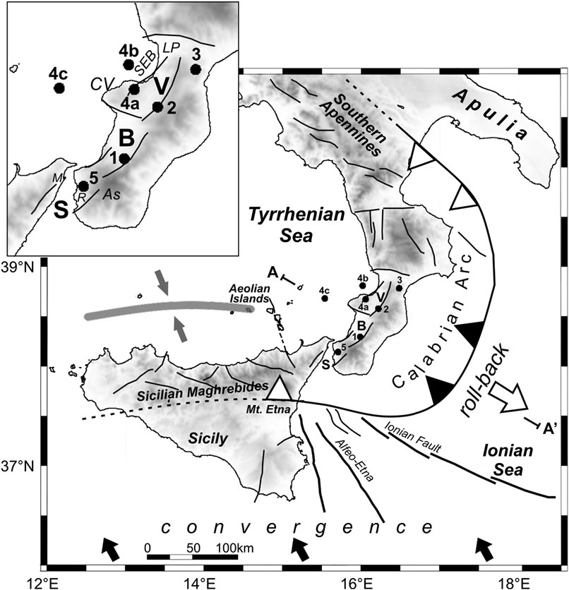
FIGURE 1. Simplified tectonic map of the Calabrian Arc region redrawn with modifications from Cadet and Funiciello (2004) and Polonia et al. (2011), with additional data from Dellong et al. (2018). The solid curve with the sawtooth pattern, pointing in the direction of subduction, indicates the present-day location of the Ionian subducting system. Black sawteeth indicate the location of the in-depth continuous subducting slab, white sawteeth show locations where the slab has already undergone detachment (Neri et al., 2009; Neri et al., 2012; Orecchio et al., 2014). The white arrow shows the sense of the gravity-induced subducting slab rollback. The black arrows schematize the sense of motion of Nubia relative to Europe in the study area (velocities of the order of 3–5 mm/yr; D’Agostino and Selvaggi, 2004; Devoti et al., 2008; Nocquet, 2012 and references therein). The gray belt and the converging arrows west of the Aeolian Islands in the southern Tyrrhenian sea show the present-day site of accommodation of convergence at the longitude of Sicily after detachment of the subduction slab and tectonic reorganization of the plate boundary. AA′ approximately indicates the NW-SE profile used for the cross-section sketch view of Figure 2. S, B, and V stand for Messina Straits, Gioia Basin, and Mesima Valley, respectively. Dots with numbers 1 to 5 show the epicenters of the earthquakes of magnitude M over 6.5 which occurred since 1600 in the southern Calabria segment of the Arc (see Table 1 for details). As = Aspromonte, CV = Capo Vaticano, LP = Lamezia Plain, M = Messina, R = Reggio Calabria, SEB = S. Eufemia basin.
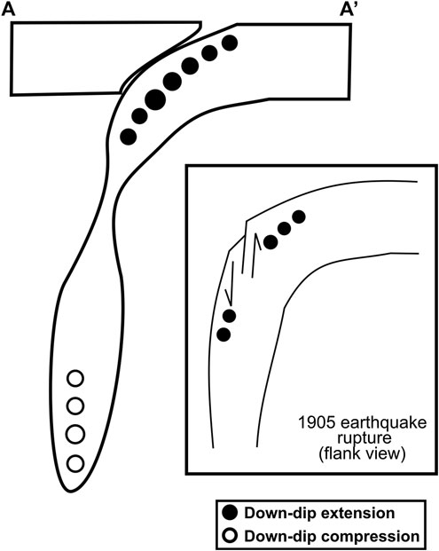
FIGURE 2. Cross-section sketch view of the subduction system along a NW-SE profile crossing southern Calabria approximately indicated as AA′ in Figure 1. The figure shows the present-day state of subduction beneath Southern Calabria in the reconstruction given by Presti et al. (2019). Clear necking of the founding slab has occurred at a depth of ca. 150 km but slab detachment has not happened, yet. The upper part of the slab located above the necking zone is subjected to down-dip extension under its own weight. This may generate seismic effects like those observed in 1905 when the upper, elbow zone of the slab ruptured, producing the magnitude 7.5 earthquake of southern Calabria [a sketch of this process redrawn from Presti et al. (2017), with modifications, is reported in the inset of this figure]. The 1905 rupture occurred on a high-dip plane parallel to the SW-NE subduction trench orientation, with the most advanced northwestern part of the slab slipping down with respect to the southeastern part (Presti et al., 2017).
In the present study, we are going i) to examine data of historical and recent seismicity of southern Calabria and ii) to compare the main features of seismicity with geodetic data and geodynamic information available from literature. We attempt to give a unifying view of the data available and to identify future strategies for the solution of the still existing model uncertainties and ambiguities.
Geodynamic Features of the Study Region
As described more widely in previous papers (see, e.g., Presti et al., 2013), the Calabrian Arc is a curved orogeny corresponding to the sector of maximum curvature of the Apennine-Maghrebian chain in the central Mediterranean (Figure 1). Many investigators (Malinverno and Ryan, 1986; Faccenna et al., 1996, among others) have suggested that geologic and geophysical data in the Calabrian Arc region can be interpreted in the framework of a geodynamic model assuming the co-existence of i) NNW-SSE convergence of Nubia and Europe plates and ii) gravity-induced SE-ward rollback of the Ionian lithospheric slab subducting to NW beneath the Tyrrhenian lithosphere (Figure 1). Nubia has been slowly converging toward Europe during the last ca. 80 Myr and NW-dipping subduction and ensuing rollback are thought to have started about 35–30 Myr ago (see, e.g., Dellong et al., 2020 and references therein). Current plate convergence velocity in this region is estimated to be on the order of 3–5 mm/yr (see, e.g., D’Agostino and Selvaggi, 2004; Devoti et al., 2008), rollback of the subducting slab is also believed to be quite slow (a couple of mm/yr; see, e.g., Hollenstein et al., 2003; Devoti et al., 2008; Nocquet, 2012). Much faster rollback (velocity was ∼8 cm/yr about 5 Myr ago and has been progressively decreasing in more recent times) is believed to have been the primary tectonic source for SE-ward kinematics of the southern Tyrrhenian unit and its overthrusting onto the Ionian lithosphere (Faccenna et al., 1996). The Calabrian Arc curved segment of the margin (Figure 1) has been recognized as a low coupling zone (Hsu, 2001).
Geologic data evidence that the Calabrian Arc (Figure 1) includes strongly contrasting vertical movements, such as mountain chain uplifting of 0.5–1.2 mm/yr in the last 1–0.7 Myr and relative-to-chain subsidence in the major tectonic troughs on the western side (same figure; Monaco et al., 1996; Faccenna et al., 2011). Normal faults located closely west of the chain are considered to be major seismogenic faults, with particular reference to the NE-trending fault systems of the Messina Straits, Gioia Basin and Mesima Valley (S, B, and V in Figure 1) believed to have generated the major earthquakes of December 28, 1908 (magnitude 7.1 according to the CPTI15 catalog; Rovida et al., 2019; Rovida et al., 2020), February 5, 1783 (7.1) and February 7, 1783 (6.7), respectively, (see, e.g., Monaco et al., 1996; Neri et al., 2006). Seismogenic stress inversion of recent earthquake fault plane solutions (Neri et al., 2004; Neri et al., 2005; Totaro et al., 2016) and analyses of geostructural data (Tortorici et al., 1995) provided evidence that these fault systems are subjected to a relatively uniform extensional stress regime with a nearly NW-SE orientation of the minimum compressive stress σ3.
Detachment of the Ionian lithospheric slab subducting beneath the Calabrian Arc was suggested by Monaco et al. (1996) to explain the uplift of the Arc in the past 1–0.7 Myr. The question on whether and eventually where the subduction slab is still continuous in depth or already detached beneath the Calabrian Arc has continued to be a primary subject of debate in more recent years (e.g., Spakman and Wortel, 2004; Neri et al., 2009). A more recent analysis of different geophysical data (gravity anomalies, seismotomographic structure, and seismicity of crust and uppermost mantle) has led Neri et al. (2012) to propose that the subducting slab is still continuous over depth beneath the central part of Calabrian Arc (southern Calabria; black sawteeth in Figure 1) while detachment of the deepest portion of subducting lithosphere has already occurred beneath the Arc edges (northern Calabria and northeastern Sicily, respectively; white sawteeth in Figure 1). On the other hand, Finite Element Modeling of lithosphere motions and strains on a regional scale (Negredo et al., 1999) has proven that the coexistence of plate convergence and rollback of an in-depth continuous subducting slab beneath the Calabrian Arc is compatible with geodetic displacement fields and chain uplift observed in Calabria. Lithospheric structures accommodating slab segmentation and roll-back have been proposed in the onshore and offshore areas around northern Calabria and northeastern Sicily (Argnani and Bonazzi, 2005; Govers and Wortel, 2005; Rosenbaum et al., 2008; Orecchio et al., 2015; Gutscher et al., 2016; Polonia et al., 2016; Dellong et al., 2018; Dellong et al., 2020).
Seismogenic stress inversion by Totaro et al. (2016) evidenced a more or less perpendicular-to-chain extensional process along the Apennine-Maghrebian chain and compressional effects of Africa-Europe slow convergence in all other sectors in the region. More in detail, the well constrained NNW-trending σ1 in the main E-trending seismogenic belt located offshore northern Sicily, and the quite diffused transcurrent regime in southeastern Sicily and Ionian offshore driven by NW- to NNW-trending σ1, mark clearly continental plate convergence (Figure 1). These results match well with the recent Nijholt et al. (2018) conclusion according to which in this south-central part of the Mediterranean region “the Calabrian Arc is now further transitioning toward a setting dominated by Africa-Europe plate convergence, whereas during the past 30 Myr slab retreat continually was the dominant factor.” In a very recent analysis based on earthquake relocations and stress inversion in the western Ionian, Presti (2020) confirmed that Africa-Europe convergence is the primary tectonic action in that sector but found also local stress heterogeneity imputable to the incipient rifting process at the southwestern edge of the subducting slab hypothesized by Polonia et al. (2017). In particular, SW-NE opening in the NW-trending belt comprised between the Alfeo-Etna and Ionian Fault Systems (Figure 1) is believed to add an extensional stress component to convergence-related compression in the offshore of Eastern Sicily (Presti, 2020).
Strong Earthquake Activity of Southern Calabria
Normal faulting appears to be the dominant faulting mechanism in southern Calabria (Figure 1; see, e.g., Ghisetti, 1984; Tortorici et al., 1995; Valensise and Pantosti, 2001). In particular, normal faulting mechanisms have been proposed for some devastating earthquakes which occurred in this part of the Calabrian Arc during the last centuries, those of February 5, 1783 and February 7, 1783 and December, 28 1908 (see locations in Figure 1 and detailed descriptions given later on in this section). For these earthquakes, however, the debate concerning the causative faults is still open (see below). Even larger is the spreading of hypotheses concerning the other devastating earthquake of September 8, 1905 for which all data of location, magnitude and mechanism are still very debated (more details below). We next discuss the sources proposed in the literature for the earthquakes of magnitude over 6.5 which occurred in southern Calabria since 1600 according to the CPTI15 catalog (Rovida et al., 2019; Rovida et al., 2020). These earthquakes are listed in Table 1 and indicated by numbering in the map of Figure 1. We are going to comment on the individual earthquakes following a geographical order from south to north.
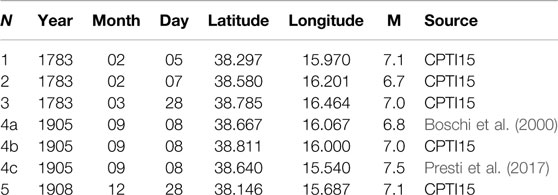
TABLE 1. Earthquakes of magnitude over 6.5 which occurred in southern Calabria since 1600 according to the CPTI15 catalog (Rovida et al., 2019; Rovida et al., 2020). N is the order number of the earthquake used also in the map of Figure 1. The other columns report the date of the earthquake (year, month, day) and its epicentral coordinates and magnitude M taken from the bibliography indicated in the last column. Three different solutions (a–c) are reported for the earthquake no. 4 of September 8, 1905.
The earthquake of December 28, 1908 (no. 5 in Figure 1 and Table 1) has been imputed to E-dipping faults with top located beneath the western side of Messina Straits (e.g., Amoruso et al., 2002; DISS Working Group, 2018) or to W-dipping faults with top located beneath the eastern side of the Straits (e.g., Tortorici et al., 1995; Aloisi et al., 2013). In particular, by joint inversion of leveling and seismic data associated to this earthquake Amoruso et al., (2002, 2006) obtained a nearly N-trending E-dipping source plane passing through Messina (M in Figure 1). On their hand, Aloisi et al. (2013) proposed a NE-striking NW-dipping fault located east of Reggio Calabria (R in Figure 1) on the grounds of geologic evidence of Holocene activity, geodetic strain, and seismicity recorded in the last decades. For the same earthquake, the DISS catalog (DISS Working Group, 2018) reports a NE-trending SE-dipping fault with top located a couple of km beneath the Sicilian coast of the Straits (Figure 1) mainly derived by work of Valensise (1988) and Valensise and Pantosti (1992). In spite of the different opinions still existing in the scientific community concerning the causative fault of this event, there is a general consensus concerning its normal faulting mechanism and the depth of the source assumed to be confined to the upper 15 km of crust. Magnitude Ms values between 6.9 and 7.2 are reported for this event in the literature (Pino et al., 2009).
Several investigators (Tortorici et al., 1995; Bosi and Galli, 2000; Jacques et al., 2001) related the earthquake of February 5, 1783 (number 1 in Figure 1 and Table 1) to a W-dipping NNE-trending normal fault separating the Aspromonte chain from the Gioia basin (Figure 1). On the other hand, an E-dipping NNE-trending blind normal fault with top beneath the Tyrrhenian shoreline of the Gioia basin was proposed as the source of the same earthquake by Valensise and D’Addezio (1994) and in the DISS catalog (DISS Working Group, 2018). Both sources are, however, confined to the upper 15–20 km of crust. A very similar situation occurs concerning the source of the earthquake of February 7, 1783 (no. 2 in Figure 1 and Table 1) for which the DISS catalog (DISS Working Group, 2018) suggests an E-dipping NNE-trending normal fault with top on the western side of the Mesima Valley (Figure 1), while Tortorici et al. (1986) and Jacques et al. (2001) proposed a NW-dipping, NNE striking normal fault separating the crystalline bedrock of the chain from the sedimentary Plio-Pleistocenic clastic sequence of the eastern side of the valley (Figure 1).
The source of the earthquake of September 8, 1905 (no. 4a–c in Figure 1 and Table 1) is even more debated: i) epicenter location onshore in the Capo Vaticano promontory area (4a in Figure 1) or offshore in the Tyrrhenian sea (4b and 4c, same figure); ii) depth estimates in the upper crust of the overriding plate (in the case of locations 4a and 4b) or at the top of the Ionian subducting slab (4c); iii) magnitude values between 6.7 and 7.5 (DISS Working Group, 2018, and references therein). Onshore or near-to-coast shallow locations and lower magnitude values come in general from macroseismic analyses of the earthquake (see, e.g., Boschi et al., 2000). The DISS catalog (DISS Working Group, 2018) reports the solution proposed by Loreto et al. (2013) on the basis of multibeam and seismic reflection analysis carried out in the S. Eufemia basin (SEB in Figure 1), i.e., a NE-striking SE-dipping normal fault defined as S. Eufemia fault. By a Bayesian non-linear location method based on use of seismic wave arrival times, Presti et al. (2017) stated that the 1905 earthquake occurred in the Tyrrhenian offshore of Calabria, a few tens km west of Capo Vaticano (4c in Figure 1), at a depth between 35 and 55 km. The same authors intervened in the current debate on location, magnitude and generation process of this major earthquake, by stating that it had a magnitude of the order of 7.5 and originated from rupture of the bending zone of the Ionian subduction slab (Figure 2B). According to Presti et al.’s reconstruction, rupture occurred on a nearly vertical plane parallel to the SW-NE subduction trench orientation, with the most advanced, northwestern part of the slab slipping down with respect to the southeastern part (Figure 2B). This process was framed by the same authors in the geodynamic model of the study region assuming slow SE-ward rollback of the Ionian subducting slab pulled by gravity (Malinverno and Ryan, 1986; Faccenna et al., 1996; Wortel and Spakman, 2000; among many others). Presti et al. (2017) showed also that the 1905 earthquake caused positive Coulomb Stress Changes on the hypothesized sources of the 1908 earthquake in the Messina Straits area, therefore favoring the occurrence of the latter at very short distance only 3 years later.
Finally, the earthquake of March 28, 1783 (no. 3 in Figure 1 and Table 1) was possibly related to a fault located in the Lamezia plain attributable to the ESE-trending, left-lateral transtensional structural system that dissects and advances the southern Calabrian Arc toward ESE (DISS Working Group, 2018). According to Jacques et al. (2001) the trace and nature of the fault that slipped during this earthquake are unclear as well as the source depth which may have been greater than in the cases of the earthquakes of February 1783 (no. 1 and 2 in Figure 1 and Table 1).
Data and Analysis
Figure 3 (built with the data available in the Italian earthquake catalog, CPTI15; Rovida et al., 2019; Rovida et al., 2020) clearly shows that the Calabrian Arc is one of the most active areas of Italy from the seismic point of view. This feature is evident from the epicenter map of the earthquakes of magnitude ≥6.0 which occurred since 1600 (panel A) as well as from the space distribution of the corresponding seismic strain rate (panel B). Time interval and magnitude threshold used for drawing this figure allow us to guarantee the completeness of the catalog over a relatively long period of time (Stucchi et al., 2011). The seismic strain rate has been estimated on a 0.2° × 0.2° grid by using the approach proposed by Jimenez-Munt et al. (2001). These authors started from the basic Kostrov (1974) relationship and assumed that each earthquake involves a strain rate effect following a Gaussian function:
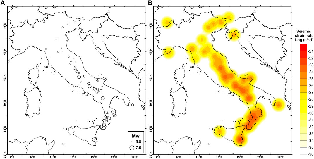
FIGURE 3. Panel (A) shows the epicentral map of the earthquakes of magnitude over 6.0 which occurred in Italy since 1600 (CPTI15; Rovida et al., 2019; Rovida et al., 2020). The corresponding spatial distribution of seismic strain is displayed in panel (B). The values of seismic strain rate have been estimated on a 0.2° × 0.2° grid by using the approach proposed by Jimenez-Munt et al. (2001).
The panel A of Figure 4 displays the space distribution of recent shallow seismicity occurring in southern Italy. The plot reports, in particular, the earthquakes of magnitude ≥3.0 occurring at depth less than 30 km between January 1, 2005 and March 31, 2020. We have located the hypocenters of these earthquakes by the Simulps standard linearized method (Evans et al., 1994) using the P and S arrival times available from the INGV bulletin database (http://terremoti.ingv.it/) and the 3D local velocity model estimated by Neri et al. (2012) by integration of crustal (Orecchio et al., 2011) and sub-crustal (Neri et al., 2009) seismotomographic models of the Tyrrhenian region. The linearized procedure of location based on time residual minimization has led to location error estimates of the order of 1 km (ERH) and 2 km (ERZ) for earthquakes located in the Calabrian Arc. Slightly larger errors of the order of 2 km (ERH) and 3 km (ERZ) were obtained in the same area by Presti et al. (2017) using the Bayloc Bayesian non-linear location algorithm. This algorithm computes a cloud of probability density for each hypocenter location and was shown to provide more reliable hypocentral uncertainties with respect to standard linearized algorithms in suboptimal network conditions (Presti et al., 2004; Presti et al., 2008). We take Bayloc’s error estimates by Presti et al. (2017) as more conservative estimates of hypocenter uncertainty in the present study. The magnitude threshold of 3 (plot A) should guarantee the completeness of the INGV seismic catalog (http://terremoti.ingv.it/) since 2005 in southern Italy and the concerned Tyrrhenian and Ionian offshores (Schorlemmer et al., 2010). Plot A shows greater density of epicenters i) near the Etna volcano in eastern Sicily, ii) in the southern Tyrrhenian sea offshore Sicily, iii) in northern Calabria, and iv) along the southern Apennines. Very low activity can be noted in the Ionian offshore of southern Calabria. To better explore this situation, we have decided to analyze for hypocentral locations all the earthquakes occurring at depth between 0 and 250 km in the rectangular area indicated in Figure 4B and to report in Figure 4C the cross section of these earthquakes taken along the profile AA′ indicated in 4B. Considering the location errors of 1 km (ERH) and 2 km (ERZ) obtained for the shallow earthquakes by the Simul linearized method, and also the more conservative values of 2 and 3 km estimated by non-linear methods (see above), we are led to conclude from Figure 4C that no significant seismicity is located at the top of the subducting slab (or subduction interface) shown in the vertical section for comparison, while seismicity is clearly detectable at shallow depth in the overriding plate and at deeper depths in the interior of the subducting slab.
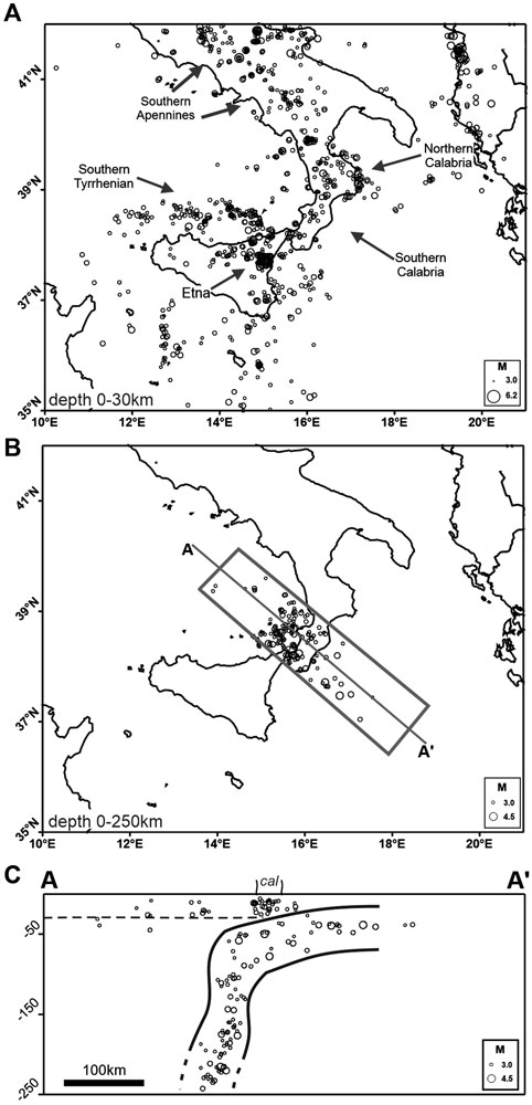
FIGURE 4. The panel (A) shows the epicentral map of earthquakes of magnitude M ≥ 3.0 which occurred at depth less than 30 km in southern Italy between January 1, 2005 and March 31, 2020. Hypocenter locations have been performed using the P- and S-readings available from INGV Bulletin database (http://terremoti.ingv.it/), the standard location method of Evans et al. (1994) and the local seismic velocity model of Neri et al. (2012). The panel (B) shows the epicentral map of the earthquakes of magnitude over 3.0 which occurred in the same period at depth less than 250 km in a NW-trending rectangular area crossing southern Calabria. The panel (C) displays the hypocenter vertical section along the profile AA′ of the earthquakes of panel (B). For comparison, the location of the Ionian subducting slab derived from data published in previous works (Lucente et al., 1999; Barberi et al., 2004; Cassinis et al., 2005; Montuori et al., 2007; Neri et al., 2009; Piana Agostinetti et al., 2009) is also reported in panel (C).
Figure 5 shows the horizontal strain rate in Italy estimated by Palano (2015) using global positioning system (GPS) data collected between 1994 and 2013. Palano’s dataset included 379 continuous GPS stations and 80 episodic GPS sites located in Sicily and the Northern Apennines in the framework of specific Projects. Palano (2015) aligned estimated GPS velocities to a fixed Eurasian reference frame, derived a continuous velocity gradient tensor on a regular 0.35° × 0.35° grid and then computed the average 2-D strain-rate tensor reported in Figure 5 (see Palano, 2015 for further details). The figure evidences clear difference between low values of 0–15 nanostrain/yr of extensional horizontal strain in southern Calabria and quite larger values of 35–55 nanostrain/yr along the rest of the Apennine extensional belt in the Italian peninsula from northern Calabria to central Italy. This finding was further evidenced in the more recent paper by Chiarabba and Palano (2017).
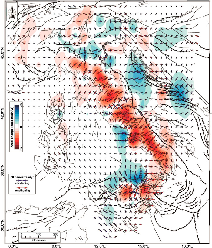
FIGURE 5. Map of geodetic horizontal strain rate in Italy reproduced from Palano (2015). The color in background shows the rate of areal change, the arrows represent the greatest extensional (red) and contractional (blue) horizontal strain rates.
Figure 6 displays the vertical displacement rates estimated by Serpelloni et al. (2013) using 2.5–14 years long position time series from more than 800 continuous GPS stations of several networks operating in the Euro-Mediterranean and African regions (see Supplementary Table S1 of Serpelloni et al., 2013). Starting from raw data the same authors analyzed the absolute IGS08 position time series to estimate tridimensional velocities. Figure 6 reports both the observed (colored circles) and the interpolated vertical velocity fields for the southern Tyrrhenian region (see Serpelloni et al., 2013 for further details). The inset displays the values of vertical displacement rates along the profile MM′ perpendicular to southern Calabria. Both representations show significant variations of vertical displacements on the territory of southern Calabria, with the eastern side of this area uplifting with respect to the western one at a rate of 1–2 mm/yr.
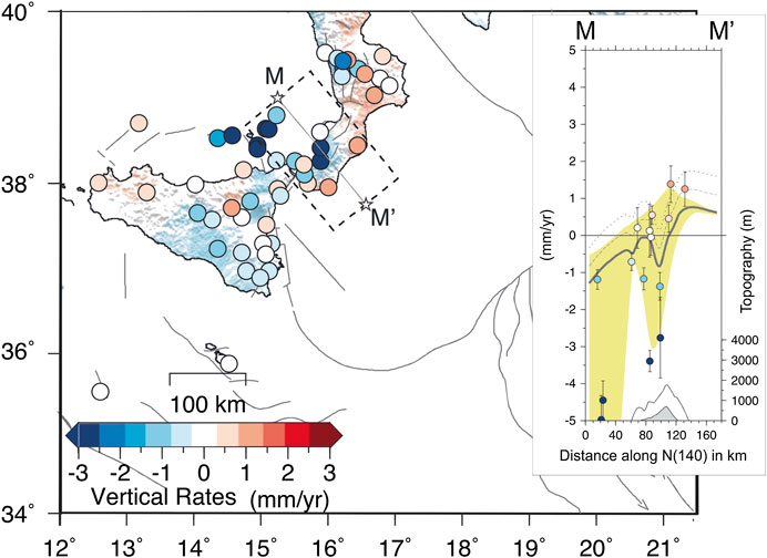
FIGURE 6. This figure is redrawn from Serpelloni et al. (2013) with combination of their Figures 10 and 13. The main plot shows the observed vertical velocity field (colored circles) over the Italian and surrounding regions. The color scale is saturated at ±3 mm/yr. Positive (red) and negative (blue) values represent uplift and subsidence vertical velocities, respectively. The inset displays the vertical velocities observed along the MM′ profile shown in the main plot (southern Calabria). See Serpelloni et al. (2013) for more details.
Even considering the approximations of the data available, the vertical displacements reported in the inset of Figure 6 appear to match well with local geologic data which indicate mountain chain uplifting of 0.5–1.2 mm/yr in the last 1–0.7 Myr and relative-to-chain subsidence in the major tectonic troughs on the western side (Monaco et al., 1996; Faccenna et al., 2011). As reported in a previous section, the zones of uplift in Calabria are predicted by numerical modeling of lithosphere motions and strains based on the assumption of coexistence of continental plate convergence and rollback of an in-depth continuous subducting slab beneath the Calabrian Arc (Negredo et al., 1999).
Discussion
The coexistence of plate convergence and subducting slab rollback in the Calabrian Arc area (more precisely in the southern Calabria segment of Calabrian Arc; Neri et al., 2012) may explain the low values of horizontal strain rate estimated by geodetic measurements in southern Calabria (Figure 5). As said in a previous section, NNW-trending plate convergence with velocity of 3–5 mm/yr is reported in the literature for this part of the Mediterranean region (see, e.g., D’Agostino and Selvaggi, 2004; Devoti et al., 2008; Nocquet, 2012). Velocity values of the order of a couple of mm/yr are reported for SE-ward rollback of the Ionian slab subducting beneath the Tyrrhenian-Calabria unit (see, e.g., Hollenstein et al., 2003; Devoti et al., 2008; Nocquet, 2012). We note that plate convergence and rollback are not parallel. With the respective values of velocity, the oblique, opposite action of lithosphere convergence and rollback in southern Calabria may justify the low value of horizontal strain rate as well as the low level of shallow seismicity detected in the Ionian offshore of southern Calabria (Figure 4). Also, it can be noted the very low level of seismicity at the top of the subducting slab in the hypocenter vertical section of Figure 4C, compatible with the thesis of weak coupling in the Calabria subduction zone (Hsu, 2001).
We attempt to frame the strong earthquake activity of southern Calabria into the geodynamic context presented above. We have said in a previous section that the strong shallow earthquakes of December 28, 1908 and February 5, 1783 and February 7, 1783 can be imputed to NE-trending normal fault systems located closely west of the chain, i.e., the Messina Straits, Gioia Basin, and Mesima Valley fault systems (S, B, and V in Figure 1). The horizontal strain rate in this area of normal-faulting strong earthquakes is low and this situation is quite different from that observed in the normal-faulting earthquake belt of the Apennine chain from central Italy to northern Calabria where horizontal strain rates are relatively large (Figure 5). Starting from Presti et al., (2017) findings concerning the magnitude 7.5 southern Calabria earthquake of 1905 (summarized in the previous section) we hypothesize that ruptures and instabilities of the upper bending part of the Ionian subducting slab may contribute to shallow seismicity of southern Calabria. Presti et al. (2017) stated that the 1905 earthquake originated at 35–55 km depth in the Tyrrhenian offshore of Calabria (epicenter location 4c in Figure 1) and was due to rupture in the elbow zone of the subducting slab occurring on a nearly vertical plane parallel to the subduction trench orientation (Figure 2B). The same authors related this rupture process to gravity pull of the Ionian subducting slab and found also that it caused significant, positive Coulomb Stress Changes on the source of the 1908 earthquake in the Messina Straits area. In a more recent paper, Presti et al. (2019) analyzed the magnitude 4.5 southern Calabria earthquake of July 14, 2018, identified as the only earthquake of magnitude over 4.0 occurring in the last three decades in the same area and depth range (30–70 km) of the 1905 earthquake. The 2018 earthquake was located at about 60 km depth in the seismogenic core of the descending slab. Based on necking of the descending slab and seismicity increase detected at depths around 150 km, Presti et al. (2019) proposed that i) the slab is approaching detachment at this depth and ii) the part of the slab above necking may be subjected to down-dip extension under its own weight, that is, under gravity pull due to the same mass located above the necking zone. The same authors concluded that down-dip extension of the upper slab produces diffused seismogenic stress acting in the inner core of the slab (2018 event) and in the top-elbow zone of it (1905).
We suggest that relatively deep dynamics may concur to normal-faulting shallow seismicity in southern Calabria. Gravity-pull of the upper part of the Ionian subducting slab (that located above necking) may cause ruptures and instabilities in the shallowest portion of the descending slab which, in turn, may perturb stress acting on the normal faults in the Calabria-Tyrrhenian overriding plate (Figure 7) favoring the occurrence of shallow earthquakes. These processes of rupture/instability in the upper slab and the related seismicity in the overriding plate (strong normal-faulting earthquakes) may occur in the presence of low horizontal strain rate.
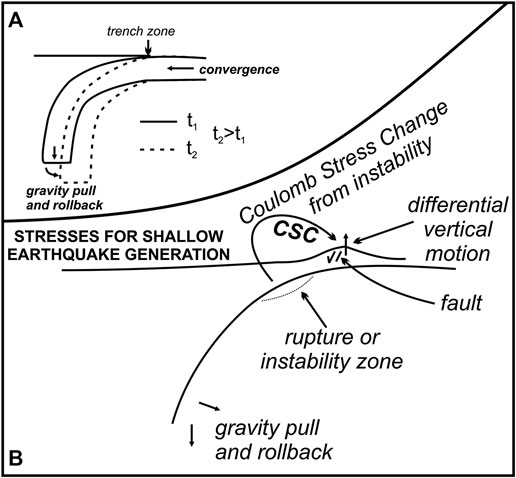
FIGURE 7. Panel (A) reports a sketch representation of the gravity-induced subduction slab rollback and plate convergence in southern Calabria. The continuous and dashed lines indicate the location of the rollbacking slab at different times t1 and t2, with t2 > t1. Rollback and convergence are oriented SE- and NNW-ward, respectively. Their almost opposite motions tend to balance each other, what causes very low horizontal strain rate at Earth’s surface and gradually decreasing coupling between the subducting and overriding plates. The detail of the contact zone between subducting slab and overthrusting plate shown in panel (B) furnishes a schematic view of seismogenic processes occurring at shallow depth in the overriding plate (Tyrrhenian-southern Calabria unit). In our reconstruction, instabilities of the upper part of the Ionian subducting slab (such as the 1905 major earthquake; see also Figure 2) and chain-to-valley differential vertical motion detected at surface would play the role of dynamic sources of normal-faulting earthquake activity occurring at shallow depth in southern Calabria. Basically, major shallow earthquakes of southern Calabria result from complex interaction between different dynamic factors (subduction slab rollback and plate convergence) and, finally, from vertical dynamics produced by this interaction.
3D reconstruction of the Calabrian Subduction Interface (CSI) led Maesano et al. (2017) to estimate a maximum moment magnitude of ∼8 in the CSI framework, corresponding to seismic rupture over the whole length of the trench under condition of full coupling. The same authors claim that the dearth of shallow seismicity related to the CSI can either suggest that it is enduring interseismic locking or is aseismic, with the second hypothesis implying that plate convergence is spent through other mechanisms rather than interplate earthquakes. On their hand, Carafa et al. (2017) suggested high interseismic coupling with low seismic coupling on the same subduction interface, i.e., elastic strain accumulating on the interface would be released episodically in creep events.
Our reconstruction of the dynamic processes occurring in the study region includes the reduction of convergence-related compressional effects due to the opposite action by rollback (Figure 7). Coupling would be gradually decreasing at the subduction interface and this may explain the dearth of thrust seismicity on the CSI. This view matches well with the above mentioned findings of Hsu (2001) according to which the Calabria subduction zone represents a weak plate coupling zone. It can also be speculated that the long period of completeness of the historical catalog of Italian earthquakes (estimated to be of the order of 7 and 5 centuries for M7 and M6 earthquakes, respectively; Stucchi et al., 2011) may, at some extent, weaken the hypothesis of enduring interseismic locking on the CSI. Analyses of displacements on the subduction interface by inversion of geodetic data, similar to those proposed for Japan by Yokota et al. (2016, 2018), would be useful in this connection, but the location of our subduction zone including the western Ionian sea, Calabria, and the southeastern Tyrrhenian sea (Figure 1) does require contribution by offshore monitoring of crustal displacements, that is not available at present. Finally, we remark that our reconstruction of the local geodynamics based on coexistence of convergence and rollback processes in a low-coupling scenario appears to be coherent with inferences from comparisons between crustal strain fields and Fast Polarization Directions of seismic wave propagation below the crust (Palano, 2015). Along-Arc Fast Polarization Directions attitudes revealing maximum horizontal extension perpendicular to orientation found by geodetic strain analyses in the upper crust was proposed as an evidence of different deformation mechanisms of crust and mantle in the framework of the ongoing subduction and rollback of the Ionian slab (Palano, 2015).
Conclusion
Low horizontal strain rate associated with the main features of seismicity and marked spatial variation of vertical displacement in southern Calabria suggest a new view of dynamic processes and seismogenesis in one of the highest seismic hazard areas in Italy. While marked extension is observed along the Apennine chain between central Italy and northern Calabria with areal change values as large as 55–35 nanostrain/yr, and this closely corresponds to normal-faulting strong seismicity, the southern Calabria segment of the chain displays relatively low extension between 0 and 15 nanostrain/yr although normal-faulting earthquake activity is here even stronger than along the rest of the Apennine chain. Based also on recent results concerning relationships between intermediate and shallow earthquakes occurring in southern Calabria, we suggest that the observed patterns of ground deformation and seismicity in this specific segment of the chain may be explained with low coupling between the Ionian subducting slab and the Tyrrhenian overriding plate. The opposite action of plate convergence and subduction slab rollback, leading to low coupling, may justify low values of horizontal strain rate. Also, the coexistence of lithosphere convergence and rollback is compatible with GPS and geologic evidence of marked spatial variation of vertical displacement rate in southern Calabria. Ruptures or instabilities in the upper bending part of the Ionian subducting slab due to slab gravity pull are able to perturb shallow normal faults located in the overriding Tyrrhenian plate and may concur to shallow seismicity of southern Calabria. In other words, normal-faulting earthquakes occurring at shallow depth in southern Calabria would be produced by the joint action of i) the dynamics of chain/valley differential vertical movements and ii) the Coulomb Stress Changes due to ruptures or instabilities of the upper bending zone of the subducting slab. New work for comprehensive quantitative description of these processes, based on Finite Element Modeling of the plate boundary in southern Calabria, is being planned as the next step of this research.
Data Availability Statement
Publicly available datasets were analyzed in this study. These data can be found here: www.ingv.it.
Author Contributions
GN and BO: coordination of the study. SS and CT: data collection and analysis, and contributions to interpretation of results.
Conflict of Interest
The authors declare that the research was conducted in the absence of any commercial or financial relationships that could be construed as a potential conflict of interest.
References
Aloisi, M., Bruno, V., Cannavò, F., Ferranti, L., Mattia, M., Monaco, C., et al. (2013). Are the source models of the M 7.1 1908 Messina Straits earthquake reliable? Insights from a novel inversion and a sensitivity analysis of levelling data. Geophys. J. Int. 192 (3), 1025–1041. doi:10.1093/gji/ggs062
Amoruso, A., Crescentini, L., Neri, G., Orecchio, B., and Scarpa, R. (2006). Spatial relation between the 1908 Messina Straits earthquake slip and recent earthquake distribution. Geophys. Res. Lett. 33 (17), L17309. doi:10.1029/2006GL027227
Amoruso, A., Crescentini, L., and Scarpa, R. (2002). Source parameters of the 1908 Messina Straits, Italy, earthquake from geodetic and seismic data. J. Geophys. Res. 107 (B4), ESE 4-1–ESE 4-11. doi:10.1029/2001JB000434
Argnani, A., and Bonazzi, C. (2005). Malta escarpment fault zone offshore eastern Sicily: Pliocene-quaternary tectonic evolution based on new multichannel seismic data. Tectonics 24 (4), TC4009. doi:10.1029/2004tc001656
Barberi, G., Cosentino, M. T., Gervasi, A., Guerra, I., Neri, G., and Orecchio, B. (2004). Crustal seismic tomography in the Calabrian Arc region, south Italy. Phys. Earth Planet. In. 147 (4), 297–314. doi:10.1016/j.pepi.2004.04.005
Boschi, E., Guidoboni, E., Ferrari, G., Mariotti, D., Valensise, G., and Gasperini, P. (2000). Catalogue of strong Italian earthquakes, 461 B.C. to 1997. Ann. Geofisc. 43, 609–868 (with database on CD-ROM). doi:10.4401/ag-3668
Bosi, V., and Galli, P. (2000). “Paleoseismic investigation along the February 5, 1783 earthquake ruptures (Cittanova fault, Calabria, southern Italy),” in Proceedings of the XXVII General Assembly of the European Seismological Commission (ESC), Lisbon, Portugal, September 10–15, 2000 (European Seismological Commission), 69. Available at: http://www.esc-web.org/the-esc-general-assembly/164-xxvii-lisbon-portugal.html.
Cadet, J.-P., and Funiciello, R. (2004). Carte géodynamique de la Méditerranée. Paris, France: Commission for the Geological Map of the World.
Carafa, M. M., Valensise, G., and Bird, P. (2017). Assessing the seismic coupling of shallow continental faults and its impact on seismic hazard estimates: a case-study from Italy. Geophys. J. Int. 209 (1), 32–47. 10.1093/gji/ggx002
Cassinis, R., Scarascia, S., and Lozej, A. (2005). “Review of seismic wide-angle reflection-refraction (WARR) results in the Italian region (1956–1987),” in Crop project: deep seismic exploration of the central Mediterranean and Italy. Editor I. R. Finetti (Amsterdam, Netherlands: Elsevier), 31–55.
Chiarabba, C., and Palano, M. (2017). Progressive migration of slab break-off along the southern Tyrrhenian plate boundary: constraints for the present day kinematics. J. Geodyn. 105, 51–61. doi:10.1016/j.jog.2017.01.006
D’Agostino, N., and Selvaggi, G. (2004). Crustal motion along the Eurasia-Nubia plate boundary in the Calabrian Arc and Sicily and active extension in the Messina Straits from GPS measurements. J. Geophys. Res. Solid Earth 109 (B11), B11402. doi:10.1029/2004JB002998
Dellong, D., Klingelhoefer, F., Dannowski, A., Kopp, H., Murphy, S., Graindorge, D., et al. (2020). Geometry of the deep Calabrian subduction (central Mediterranean Sea) from wide-angle seismic data and 3-D gravity modeling. Geochem. Geophy. Geosy. 21, 3. doi:10.1029/2019GC008586
Dellong, D., Klingelhoefer, F., Kopp, H., Graindorge, D., Margheriti, L., Moretti, M., et al. (2018). Crustal structure of the Ionian Basin and eastern Sicily margin: results from a wide-angle seismic survey. J. Geophys. Res. Solid Earth 123, 2090–2114. doi:10.1002/2017jb015312
Devoti, R., Riguzzi, F., Cuffaro, M., and Doglioni, C. (2008). New GPS constraints on the kinematics of the Apennines subduction. Earth Planet Sci. Lett. 273, 163–174. doi:10.1016/j.epsl.2008.06.031
DISS Working Group (2018). Database of individual seismogenic sources (DISS), version 3.2.1: a compilation of potential sources for earthquakes larger than M 5.5 in Italy and surrounding areas (Rome: Istituto Nazionale di Geofisica e Vulcanologia). Available at: http://diss.rm.ingv.it/diss/ (Accessed May, 2020).
Evans, J. R., Eberhart-Phillips, D., and Thurber, C. H. (1994). Open File Report. User’s manual for simulps12 for imaging Vp and Vp/Vs: a derivative of the “Thurber” tomographic inversion simul3 for local earthquakes and explosions. Menlo Park, CA: USGS, Menlo Park, 94–431.
Faccenna, C., Davy, P., Brun, J.-P., Funiciello, R., Giardini, D., Mattei, M., et al. (1996). The dynamics of back-arc extension: an experimental approach to the opening of the Tyrrhenian Sea. Geophys. J. Int. 126, 781–795. doi:10.1111/j.1365-246x.1996.tb04702.x
Faccenna, C., Molin, P., Orecchio, B., Olivetti, V., Bellier, O., Funiciello, F., et al. (2011). Topography of the Calabria subduction zone (southern Italy): clues for the origin of Mt. Etna. Tectonics 30, TC1003. doi:10.1029/2010TC002694
Ghisetti, F. (1984). Recent deformations and the seismogenic source in the Messina Strait (southern Italy). Tectonophysics 109, 191–208. doi:10.1016/0040-1951(84)90140-9
Govers, R., and Wortel, M. J. R. (2005). Lithosphere tearing at STEP faults: response to edges of subduction zones. Earth Planet Sci. Lett. 236, 505–523. doi:10.1016/j.epsl.2005.03.022
Gutscher, M.-A., Dominguez, S., de Lepinay, B. M., Pinheiro, L., Gallais, F., Babonneau, N., et al. (2016). Tectonic expression of an active slab tear from high-resolution seismic and bathymetric data offshore Sicily (Ionian Sea). Tectonics 35(1), 39–54. doi:10.1002/2015tc003898
Hollenstein, C., Kahle, H. G., Geiger, A., Jenny, S., Goes, S., and Giardini, D. (2003). New GPS constraints on the Africa-Eurasia plate boundary zone in southern Italy. Geophys. Res. Lett. 30 (18), 1935. doi:10.1029/2003gl017554
Hsu, S. K. (2001). Lithospheric structure, buoyancy and coupling across the southernmost Ryukyu subduction zone: an example of decreasing plate coupling. Earth Planet Sci. Lett. 186 (3–4), 471–478. doi:10.1016/s0012-821x(01)00261-8
Jacques, E., Monaco, C., Tapponnier, P., Tortorici, L., and Winter, T. (2001). Faulting and earthquake triggering during the 1783 Calabria seismic sequence. Geophys. J. Int. 147, 499–516. doi:10.1046/j.0956-540x.2001.01518.x
Jiménez-Munt, I., Fernàndez, M., Torne, M., and Bird, P. (2001). The transition from linear to diffuse plate boundary in the Azores-Gibraltar region: results from a thin-sheet model. Earth Planet Sci. Lett. 192, 175–189. doi:10.1016/s0012-821x(01)00442-3
Kostrov, V. (1974). Seismic moment and energy of earthquakes, and seismic flow of rock. Izv. Acad. Sci. USSR Phys. Solid Earth. 1, 23–44.
Loreto, M. F., Fracassi, U., Franzo, A., Del Negro, P., Zgur, F., and Facchin, L. (2013). Approaching the seismogenic source of the Calabria 8 September 1905 earthquake: new geophysical, geological and biochemical data from the S. Eufemia Gulf (S Italy). Mar. Geol. 343, 62–75. doi:10.1016/j.margeo.2013.06.016
Lucente, F. P., Chiarabba, C., Cimini, G. B., and Giardini, D. (1999). Tomographic constraints on the geodynamic evolution of the Italian region. J. Geophys. Res. 104 (B9), 20307–20327. doi:10.1029/1999JB900147
Maesano, F. E., Tiberti, M. M., and Basili, R. (2017). The Calabrian Arc: three-dimensional modelling of the subduction interface. Sci. Rep. 7, 8887. doi:10.1038/s41598-017-09074-8
Malinverno, A., and Ryan, W. B. F. (1986). Extension in the Tyrrhenian Sea and shortening in the Apennines as result of arc migration driven by sinking of the lithosphere. Tectonics 5 (2), 227–245. doi:10.1029/TC005i002p00227
Monaco, C., Tortorici, L., Nicolich, R., Cernobori, L., and Costa, M. (1996). From collisional to rifted basins: an example from the southern Calabrian arc (Italy). Tectonophysics 266 (1–4), 233–249. doi:10.1016/S0040-1951(96)00192-8
Montuori, C., Cimini, G. B., and Favali, P. (2007). Teleseismic tomography of the southern Tyrrhenian subduction zone: new results from seafloor and land recordings. J. Geophys. Res. 112, B3. doi:10.1029/2005JB004114
Negredo, A. M., Carminati, E., Barba, S., and Sabadini, R. (1999). Dynamic modelling of stress accumulation in central Italy. Geophys. Res. Lett. 26 (13), 1945–1948. doi:10.1029/1999GL900408
Neri, G., Barberi, G., Oliva, G., and Orecchio, B. (2004). Tectonic stress and seismogenic faulting in the area of the 1908 Messina earthquake, south Italy. Geophys. Res. Lett. 31 (10), L10602. doi:10.1029/2004GL019742
Neri, G., Barberi, G., Oliva, G., and Orecchio, B. (2005). Spatial variations of seismogenic stress orientations in Sicily, south Italy. Phys. Earth Planet. In. 148, 175–191. doi:10.1016/j.pepi.2004.08.009
Neri, G., Marotta, A. M., Orecchio, B., Presti, D., Totaro, C., Barzaghi, R., et al. (2012). How lithospheric subduction changes along the Calabrian Arc in southern Italy: geophysical evidences. Int. J. Earth Sci. 101, 1949–1969. doi:10.1007/s00531-012-0762-7
Neri, G., Oliva, G., Orecchio, B., and Presti, D. (2006). A possible seismic gap within a highly seismogenic belt crossing Calabria and eastern Sicily, Italy, Bull. Seismol. Soc. Am. 96, 1321–1331. doi:10.1785/0120050170
Neri, G., Orecchio, B., Totaro, C., Falcone, G., and Presti, D. (2009). Subduction beneath southern Italy close the ending: results from seismic tomography. Seismol. Res. Lett. 80 (1), 63–70. doi:10.1785/gssrl.80.1.63
Nijholt, N., Govers, R., and Wortel, R. (2018). On the forces that drive and resist deformation of the south-central Mediterranean: a mechanical model study. Geophys. J. Int. 214 (2), 876–894. doi:10.1093/gji/ggy144
Nocquet, J.-M. (2012). Present-day kinematics of the Mediterranean: a comprehensive overview of GPS results. Tectonophysics 579, 220–242. doi:10.1016/j.tecto.2012.03.037
Orecchio, B., Presti, D., Totaro, C., D’Amico, S., and Neri, G. (2015). Investigating slab edge kinematics through seismological data: the northern boundary of the Ionian subduction system (south Italy). J. Geodyn. 88, 23–35. doi:10.1016/j.jog.2015.04.003
Orecchio, B., Presti, D., Totaro, C., Guerra, I., and Neri, G. (2011). Imaging the velocity structure of the Calabrian Arc region (south Italy) through the integration of different seismological data. Boll. Geofis. Teor. Appl. 52, 625–638. doi:10.4430/bgta0023
Orecchio, B., Presti, D., Totaro, C., and Neri, G. (2014). What earthquakes say concerning residual subduction and STEP dynamics in the Calabrian arc region, south Italy. Geophys. J. Int. 199 (3), 1929–1942. doi:10.1093/gji/ggu373
Palano, M. (2015). On the present-day crustal stress, strain-rate fields and mantle anisotropy pattern of Italy. Geophys. J. Int. 200 (2), 969–985. doi:10.1093/gji/ggu451
Piana Agostinetti, N., Steckler, M. S., and Lucente, F. P. (2009). Imaging the subducted slab under the Calabrian Arc, Italy, from receiver function analysis. Lithosphere 1 (3), 131–138. doi:10.1130/L49.1
Pino, N. A., Piatanesi, A., Valensise, G., and Boschi, E. (2009). The 28 December 1908 Messina Straits earthquake (Mw 7.1): a great earthquake throughout a century of seismology. Seismol Res. Lett. 80 (2), 243–259. doi:10.1785/gssrl.80.2.243
Polonia, A., Torelli, L., Artoni, A., Carlini, M., Faccenna, C., Ferranti, L., et al. (2016). The Ionian and Alfeo-Etna fault zones: new segments of an evolving plate boundary in the central Mediterranean Sea? Tectonophysics 675, 69–90. doi:10.1016/j.tecto.2016.03.016
Polonia, A., Torelli, L., Gasperini, L., Cocchi, L., Muccini, F., Bonatti, E., et al. (2017). Lower plate serpentinite diapirism in the Calabrian Arc subduction complex. Nat. Commun. 8 (1), 1–13. doi:10.1038/s41467-017-02273-x
Polonia, A., Torelli, L., Mussoni, P., Gasperini, L., Artoni, A., and Klaeschen, D. (2011). The Calabrian Arc subduction complex in the Ionian Sea: regional architecture, active deformation, and seismic hazard. Tectonics 30 (5), TC5018. doi:10.1029/2010TC002821
Presti, D. (2020). Seismicity supports the theory of incipient rifting in the western Ionian Sea, central Mediterranean. Ann. Geophys. 63 (2), 225. 10.4401/ag-8360
Presti, D., Billi, A., Orecchio, B., Totaro, C., Faccenna, C., and Neri, G. (2013). Earthquake focal mechanisms, seismogenic stress, and seismotectonics of the Calabrian Arc, Italy, Tectonophysics 602, 153–175. doi:10.1016/j.tecto.2013.01.030
Presti, D., Neri, G., Orecchio, B., Scolaro, S., and Totaro, C. (2017). The 1905 Calabria, southern Italy, earthquake: hypocenter location, causative process, and stress changes induced in the area of the 1908 Messina Straits earthquake. Bull. Seismol. Soc. Am. 107 (6), 2613–2623. doi:10.1785/0120170094
Presti, D., Orecchio, B., Falcone, G., and Neri, G. (2008). Linear versus non-linear earthquake location and seismogenic fault detection in the southern Tyrrhenian Sea, Italy, Geophys. J. Int. 172, 607–618. doi:10.1111/j.1365-246x.2007.03642.x
Presti, D., Totaro, C., Neri, G., and Orecchio, B. (2019). New earthquake data in the Calabrian subduction zone, Italy, suggest revision of the presumed dynamics in the upper part of the subducting slab. Seismol Res. Lett. 90 (5), 1994–2004. doi:10.1785/0220190024
Presti, D., Troise, C., and De Natale, G. (2004). Probabilistic location of seismic sequences in heterogeneous media. Bull. Seismol. Soc. Am. 94, 2239–2253. doi:10.1785/0120030160
Rosenbaum, G., Gasparon, M., Lucente, F. P., Peccerillo, A., and Miller, M. S. (2008). Kinematics of slab tear faults during subduction segmentation and implications for Italian magmatism. Tectonics 27 (2), TC2008. doi:10.1029/2007tc002143
Rovida, A., Locati, M., Camassi, R., Lolli, B., and Gasperini, P. (2019). Catalogo parametrico dei terremoti Italiani (CPTI15), versione 2.0 (Rome: Istituto Nazionale di Geofisica e Vulcanologia (INGV)) Available at: https://emidius.mi.ingv.it/CPTI15-DBMI15/.
Rovida, A., Locati, M., Camassi, R., Lolli, B., and Gasperini, P. (2020). The Italian earthquake catalogue CPTI15. Bull. Earthq. Eng. 18 (7), 2953–2984. doi:10.1007/s10518-020-00818-y
Schorlemmer, D., Mele, F., and Marzocchi, W. (2010). A completeness analysis of the National Seismic Network of Italy. J. Geophys. Res. Solid Earth 115 (B4), B04308. doi:10.1029/2008jb006097
Serpelloni, E., Faccenna, C., Spada, G., Dong, D., and Williams, S. D. P. (2013). Vertical GPS ground motion rates in the Euro-Mediterranean region: new evidence of velocity gradients at different spatial scales along the Nubia-Eurasia plate boundary. J. Geophys. Res. Solid Earth 118 (11), 6003–6024. doi:10.1002/2013jb010102
Spakman, W., and Wortel, R. (2004). “A tomographic view on western Mediterranean geodynamics,” in The TRANSMED Atlas. The Mediterranean region from crust to mantle. Editors W. Cavazza, F. Roure, W. Spakman, G. M. Stampfli, and P. A. Ziegler (Heidelberg, Germany: Springer-Verlag), 31–52.
Stucchi, M., Meletti, C., Montaldo, V., Crowley, H., Calvi, G. M., and Boschi, E. (2011). Seismic hazard assessment (2003–2009) for the Italian building code. Bull. Seismol. Soc. Am. 101 (4), 1885–1911. doi:10.1785/0120100130
Tortorici, L., Monaco, C., Tansi, C., and Cocina, O. (1995). Recent and active tectonics in the Calabrian Arc (southern Italy). Tectonophysics 243, 37–55. doi:10.1016/0040-1951(94)00190-k
Tortorici, L., Tapponnier, P., and Winter, T. (1986). Faulting during the 1783 Calabria earthquakes and tectonics of the Messina Strait. EOS Trans. AGU 67, 1188.
Totaro, C., Orecchio, B., Presti, D., Scolaro, S., and Neri, G. (2016). Seismogenic stress field estimation in the Calabrian Arc region (south Italy) from a Bayesian approach. Geophys. Res. Lett. 43 (17), 8960–8969. doi:10.1002/2016GL070107
Valensise, G. (1988). Low angle normal faulting during the 1908, Messina, earthquake revealed by geodetic data analysis. Eos Trans. AGU 69 (44), F1433.
Valensise, G., and D’Addezio, G. (1994). I.N.G. Internal Report. Il contributo della geologia di superficie all’identificazione delle strutture sismogenetiche della Piana di Gioia Tauro, 559.
Valensise, G., and Pantosti, D. (1992). A 125 Kyr-long geological record of seismic source repeatability: the Messina Straits (southern Italy) and the 1908 earthquake (Ms7/2). Terra. Nova 4 (4), 472–483. doi:10.1111/j.1365-3121.1992.tb00583.x
Valensise, G., and Pantosti, D. (2001). Database of potential sources for earthquakes larger than M 5.5 in Italy. Ann. Geofisc. 44 (Suppl. 1), 180, 2001 (with database on CD-ROM).
Wortel, M. J. R., and Spakman, W. (2000). Subduction and slab detachment in the Mediterranean-Carpathian region. Science 290, 1910–1917. doi:10.1126/science.290.5498.1910
Yokota, Y., Ishikawa, T., and Watanabe, S. (2018). Seafloor crustal deformation data along the subduction zones around Japan obtained by GNSS-A observations. Sci. data 5, 180–182. doi:10.1038/sdata.2018.182
Keywords: earthquakes, geodetic strain, geodynamics, southern Calabria, Italy
Citation: Neri G, Orecchio B, Scolaro S and Totaro C (2020) Major Earthquakes of Southern Calabria, Italy, Into the Regional Geodynamic Context. Front. Earth Sci. 8:579846. doi: 10.3389/feart.2020.579846
Received: 03 July 2020; Accepted: 19 August 2020;
Published: 11 September 2020.
Edited by:
Ioannis Kassaras, National and Kapodistrian University of Athens, GreeceReviewed by:
Mimmo Palano, Istituto Nazionale di Geofisica e Vulcanologia (INGV), ItalyDavid Iacopini, University of Naples Federico II, Italy
Copyright © 2020 Neri, Orecchio, Scolaro and Totaro. This is an open-access article distributed under the terms of the Creative Commons Attribution License (CC BY). The use, distribution or reproduction in other forums is permitted, provided the original author(s) and the copyright owner(s) are credited and that the original publication in this journal is cited, in accordance with accepted academic practice. No use, distribution or reproduction is permitted which does not comply with these terms.
*Correspondence: Barbara Orecchio, b3JlY2NoaW9AdW5pbWUuaXQ=