 Tvrtko Korbar1*
 Snježana Markušić2
 Ozren Hasan1Ladislav Fuček1
 Dea Brunović1
 Nikola Belić1Damir Palenik1Vanja Kastelic3
- 1Croatian Geological Survey, Zagreb, Croatia
- 2University of Zagreb, Faculty of Science, Zagreb, Croatia
- 3Istituto Nazionale di Geofisica e Vulcanologia (INGV), L’Aquila, Italy
Active tectonics in long-lived orogenic belts usually manifests on the preexisting inherited structures. In the Kvarner region of the External Dinarides, an area with low-to-moderate seismicity related to the Adriatic microplate (Adria) northward movement, we deal with faults in predominantly carbonate rocks within tectonically complex NW-SE striking fold-and-thrust belt, which makes the identification and parametrization of the active structures challenging. Moreover, anthropogenic modifications greatly complicate access to the surface geological and geomorphological data. This paper demonstrates results of focused multidisciplinary research, from surface geological mapping and offshore shallow seismic surveys to earthquake focal mechanisms, as an active fault identification and parametrization kit, with a final goal to produce an across-methodological integrated model of the identified features in the future. Reverse, normal, and strike-slip orogen-parallel (longitudinal) to transverse faults were identified during geological mapping, but there is no clear evidence of their mutual relations and possible recent activity. The focal mechanisms calculated from the instrumental record include weak-to-moderate earthquakes and show solutions for all faulting types in the upper crust, compatible with the NE-SW oriented principal stress direction, with the stronger events favoring reverse and strike-slip faulting. The 3D spatial and temporal distribution of recent earthquake hypocenters indicate their clustering along predominantly subvertical transversal and steeply NE-dipping longitudinal planes. High-resolution shallow seismic geoacoustical survey (subbottom profiler) of the Quaternary sediments in the Rijeka Bay revealed local tectonic deformations of the stratified Late Pleistocene deposits that, along with overlaying mass-transport deposits, could imply prehistorical strong earthquake effects. Neotectonic faults onshore are tentatively recognized as highly fractured zones characterized by enhanced weathering, but there is no evidence for its recent activity. Thus, it seems that the active faults are blind and situated below the thin-skinned and highly deformed early-orogenic tectonic cover of the Adria. A strain accumulating deeper in the crust is probably irregularly redistributed near the surface along the preexisting fault network formed during the earlier phases of the Dinaric orogenesis. The results indicate a need for further multidisciplinary research that will contribute to a better seismic hazard assessment in the densely populated region that is also covered by strategic infrastructure.
Introduction
Kvarner region (Croatia) is situated in the NW part of the External Dinarides (Figure 1A) and is built of deformed, uplifted, and eroded Mesozoic to Cenozoic predominantly carbonate rocks (Figure 1B). The rocks represent detached and backthrust preorogenic upper sedimentary cover of the northeast moving Adria (Apulia is a synonym, Figure 1C) during the main phase of the Alpine orogenesis in the region (Schmid et al., 2008), when a tectonically complex NW-SE striking (so-called Dinaric strike) fold-and-thrust belt has been formed in the area (Tari, 2002; Korbar, 2009).
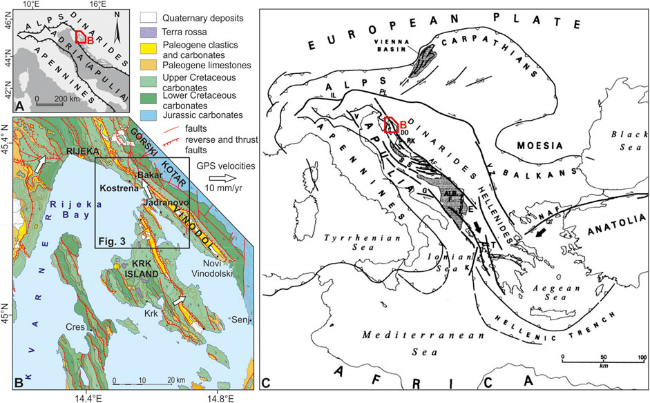
FIGURE 1. (A) A sketch map of the orogenic fronts in the Adriatic region and the position of the Kvarner region (red frame). (B) Overview geological map of the Kvarner region (modified after HGI, 2009) and the position of the investigated area Bakar-Krk (small frame). (C) Overview tectonic map showing major tectonic lineaments in central-southern Europe (from Picha, 2002). Note a regionally significant NE Adriatic fault zone (AF) that crosses the study area (see Korbar, 2009, for details).
In the Rijeka Bay and the surrounding marine channels (Figure 1A), the submerged karst landscape is covered with Quaternary sediments (Juračić et al., 1998). The combined influence of multiple factors such as tectonic movements, sea-level changes, climate, and lithology led to the complex geological and geomorphological evolution of the Rijeka Bay (Benac and Juračić, 1998). Erosional and accumulation processes, as well as karstification depth, changed substantially with these factors (Benac and Juračić, 1998). The formation of the present-day submerged karst landscape occurred due to the post-Last Glacial Maximum (LGM) sea-level rise (Correggiari et al., 1996; Lambeck et al., 2011; Benjamin et al., 2017). Juračić et al. (1998) estimated that the thickness of the Holocene marine sediments in the area is between 2 and 10 m. The greater thickness was determined near the mouths of permanent and ephemeral rivers and streams (Juračić et al., 1998). It is likely that there was no connection between the Rijeka Bay and the open Adriatic during glacial periods which enabled the development of different depositional environments, like karst lakes (Benac and Juračić, 1998; Juračić et al., 1999). However, no systematic subbottom studies of the Quaternary sediment cover have been conducted in this area so far, especially in the context of paleoseismology.
The differentially submerged tidal notches in the investigated area (Benac et al., 2004; Benac et al., 2008) are interpreted as a result of different tectonic subsidence related to the supposed major active thrust in the Bakar-Vinodol zone (Stiros and Moschas, 2012). However, the differential position of the tidal notches in the Bakar Bay may be related to another type of local active tectonic movement or could be of a nontectonic origin. Nevertheless, recent tectonic activity is indicated also according to the analyses of the submerged speleothems from the central coastal part of the island of Krk (Surić et al., 2005), and the results indicate a very slow tectonic uplift of the island, although subsidence is expected for the NE Adriatic islands (Surić et al., 2014).
The active tectonics in the Adriatic region is related to the motion of the Adriatic microplate (Adria or Apulia) and the interaction of the microplate with the surrounding Alpine orogenic belts: the Apennines on the southwest, the Southern Alps on the northwest, and the Dinarides on the northeast (Anderson and Jackson, 1987; Figures 1A,C). The active deformation in the orogenic belts is probably driven by the independent motion of the Adriatic plate rather than by the Africa-Eurasia convergence (Oldow et al., 2002). Under the External Dinarides, the Moho depth passes from 40 to 42 km in its NW to 45 km in the central and SE sector with local peaks of 50 km (Stipčević et al., 2020). The Adriatic lithosphere is found deeper below the SE Dinarides and shallower in the NW Dinarides (Šumanovac et al., 2017), and the Adria migrates generally to the north with respect to Europe while rotating counterclockwise around its pole in North Italy (Battaglia et al., 2004; Nocquet and Calais, 2004). Accordingly, the relative movements of Adria generally increase from the northwest to the southeast and its relative N to NE displacement in the wider Kvarner region is just a few mm/yr (Weber et al., 2010). However, the movement directions at the observed points from the investigated area vary between NW and NE (Altiner et al., 2006; Figure 1B), and it seems that the local active tectonic setting is not as simple as considered previously (Prelogović et al., 1995; Kuk et al., 2000; Placer et al., 2010). Thus, the Kvarner region is seismically moderately active, and the earthquakes occur in the upper crust probably along the tectonic contact of two major crustal segments of the Adria:Adriatic and Dinaridic (Korbar, 2009), i.e., along the NE Adriatic fault zone (Picha, 2002; AF on Figure 1C).
According to the Croatian Earthquake Catalog (CEC 2018), firstly described by Herak et al., 1996, the wider Rijeka area exhibits moderate-to-strong seismicity (Figure 2). Seismic activity here is known for frequent occurrences of relatively weak earthquakes (M < 4.0) and occasional occurrences of moderate or large ones (Ivančić et al., 2006; Ivančić et al., 2018). The earthquake hypocenters lie mostly at depths of up to 20 km, within the seismogenic tectonic zone striking in the NW-SE direction along the coastline. The Ilirska Bistrica-Rijeka-Vinodol-Senj zone is interpreted as an obliquely reverse fault system that accommodates oblique subduction of the Adriatic microplate and the compression in the Dinarides (Kuk et al., 2000; Palenik et al., 2019), along the NE Adriatic fault zone.
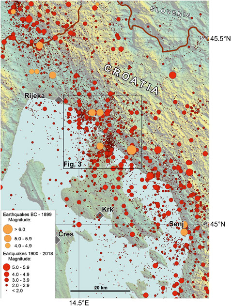
FIGURE 2. Spatial distribution of earthquakes in the Rijeka epicentral area (Kvarner region, W Croatia, and SE Slovenia) (373BC–2018, according to the Croatian Earthquake Catalog (CEC), an updated version first described in Herak et al., 1996). All the events are from shallow crustal depths (down to 25 km). Red dots are instrumentally recorded events while orange dots are historical events. The Rijeka epicentral area has a population of ∼350,000.
The regional seismic data are available in the earthquake catalog CEC 2018. It contains basic information on more than 110.000 earthquakes that occurred in the period 373BC–2018 in Croatia and the neighboring areas. The latest version of the catalog is kept in the archives of the Department of Geophysics, Faculty of Science, University of Zagreb. Figure 2 shows an overview map of the epicenters of all earthquakes that occurred in the wider Kvarner (Rijeka) area by the end of 2018 according to the CEC 2018. In addition to the recent seismic activity (the period after 1900, since the instrumental earthquake data exist), also the historical seismicity, which includes earthquakes that occurred in the period before 1900, and whose parameters were determined on the basis of reliable macroseismic data, is displayed. For the historical earthquakes, before 1900, the magnitude was derived using macroseismic data (earthquake intensity).
The most significant earthquakes (with intensities greater or equal to VII °MSK) occurred in 1323, 1750, 1776, 1838, 1870, 1904, and 1916. The strongest historical local earthquake occurred in 1323 with intensity at the epicenter I0 = IX °MSK and an estimated magnitude of 6.7. After that earthquake, there were no more significant recorded events on the Ilirska Bistrica-Vinodol fault zone until 1750 when a large earthquake series occurred in the hinterlands of the town of Bakar. The strongest event in this series happened in 1750. Until October 1754, up to 3,000 earthquakes and rumbles were felt or heard in that area (Acta Buccarana, 1751–1763, Gratianus, 1755; Tomsich, 1886; Kišpatić, 1891; Radics, 1903; Laszowski, 1923; Herak et al., 2017). Therefore, the macroseismic intensity has been estimated as a cumulative value for all the earthquakes from that series which could have caused damage to the buildings. The main event caused a lot of damage in Rijeka in a way that many people had to live in huts built at the seashore. The maximum intensity of the event is evaluated as VIII °MSK scale (estimated magnitude is M = 5.7). According to the recent data analysis for this event (Herak et al., 2017), the epicenter was located again near Bakar. A very strong earthquake occurred in 1776, and according to the historical data (Perrey, 1850), it was found that the event was most strongly felt in Bakar, but it was also felt in Rijeka and Trieste. The assigned intensity at the epicenter was VII °MSK. According to available records, in the epicentral area of the Krk Island, the strongest earthquake occurred in 1838. Maximum intensity was VII °MSK, felt on the northern part of Krk Island and around Bakar Bay. That is why the Bakar-Krk area is in the focus of our research. A destructive earthquake occurred in 1870 near Klana (10 km NW of Rijeka), with the intensity at the epicenter VIII °MSK. This is one of the most important earthquakes that happened in the vicinity of Rijeka and is very important for the seismic hazard of the wider Rijeka area. A moderately strong earthquake occurred near Bakar in 1904. The macroseismic intensity in the epicenter was estimated to be VII °MSK. A very strong earthquake occurred in 1916, about 10 km to the east from Novi Vinodolski (intensity at the epicenter was VIII °MSK). The seismograph in Zagreb recorded the event; therefore, it was possible to calculate its magnitude as 5.8.
The existing seismotectonic model of the Kvarner region is based on 2D analysis of the hypocenters used for a traditional interpretation of NE-dipping reverse seismogenic faults formed because of displacements of the Adriatic microplate segments under the Dinarides (Prelogović et al., 1995; Kuk et al., 2000). However, one of the regional geological models highlights structural complexity in the crustal scale derived from multiphase tectonics that characterizes this part of the orogenic belt (Korbar, 2009). The seismicity in the Kvarner (Rijeka) region is probably a consequence of the escape tectonics (Picha, 2002) along a relatively steep crustal fault zone striking in Dinaric direction (NW-SE) that is recognized regionally as the NE Adriatic fault zone (AF on Figure 1C). Possible active faults that belong to a wide zone of the AF are recognized during the more focused studies in this part of External Dinarides (Cunningham et al., 2006; Moulin et al., 2016; Žibret and Vrabec, 2016). Thus, there is an open question of SE continuation of the recognized active faults on the surface in the Rijeka epicentral area (Figure 2). Besides, there is an open question of a possible active tectonic role of other inferred faults, e.g., reactivated early-orogenic detachments and transversal faults to the main strike of the Dinarides. The former has been recognized on the interpreted regional geological cross section across the Velebit Mountains, while the latter are generally recognized in the investigated area as the Kvarner fault zone (see Korbar, 2009, and references therein).
There are many limitations to the research on geological structures in the area. The deep seismic profiles are available only for Rijeka Bay. However, the images are of low quality and are especially chaotic in the investigated marginal parts of the Bay. Besides, there are no boreholes in the investigated area that could allow a correlation of the low-quality seismic data. That is why the data were not useful neither in the previous seismotectonic studies in the area (Prelogović et al., 1995; Kuk et al., 2000) nor in our research.
Three composite seismogenic sources were proposed for the Rijeka Bay and Krk Island, all characterized by the Dinaric strike (Kastelic and Carafa, 2012; Kastelic et al., 2013). The more internal sources run along the shore of the mainland in Rijeka area (the northern margin of the Bay) toward SE, while the more external source occupies areas of Krk Island. The first two sources have mid-to-steep NE-dipping angles with reverse-right-lateral kinematics, while the third source has mid-NE-dipping angle with a less pronounced oblique right-lateral kinematic component. The compilation of these sources is mainly based on different geologic and morphologic data integrated with seismotectonic cross sections of the existing seismotectonic models (Kuk et al., 2000) and on the earthquake data. All sources are located in the upper crust with a maximum depth of 18 km. It has been recognized that across the region more internal faults have become steeper dipping in the course of evolution of the External Dinarides and are therefore considered long-lived features with weaker rheology (Kastelic and Carafa, 2012).
Concerning the seismic hazard in the region that is characterized by more than 350.000 inhabitants and the strategic infrastructure, the latest project was “The Harmonization of Seismic Hazard Maps in the Western Balkan Countries Project” (BSHAP), which was financed by NATO-Science for Peace Program. One of the main outputs of the project was the new probabilistic seismic hazard maps for Western Balkans (Güllerce et al., 2017). These maps were obtained by the implementation of the smoothed-gridded seismicity approach. The results are expressed in terms of peak horizontal acceleration (PGA) for 95 and 475 years return periods aligned with Eurocode eight requirements, for the soil type A. Based on these results, it can be seen that in this work investigated area is characterized with PGA in the intervals 0.06–0.08 g (for return period 95 years-probability of exceedance 10% in 10 years) and 0.16–0.20 g (for return period 475 years-probability of exceedance 10% in 50 years).
In this paper, we deal with faults in predominantly carbonate (karst) terrains built of highly deformed and fractured rocks within a tectonically complex fold-and-thrust belt, characterized by little Quaternary deposits on the highly dissected karst terrain, which makes the identification and parametrization of the active structures challenging. The region is also densely populated and anthropogenic modifications greatly complicate access to the surface geological and geomorphological data. That is why the key evidence of the active tectonics in the deep subsurface is earthquake hypocenters. We tried to find the indications of the active faults at the surface in new focused geological mapping and structural research, as well as in the shallow seismic imaging of the Quaternary sediments that cover the predominantly carbonate bedrock in the Rijeka Bay and in the surrounding channels and bays. We focused on the surroundings of the small town of Bakar and the northern part of the Krk island, the so-called Bakar-Krk area (Figures 1, 3) that is characterized by rare strong historical earthquakes, weak-to-moderate clustered events (tremors), relatively well-known surface geology, and the recognized Quaternary subbottom sediment deformations.
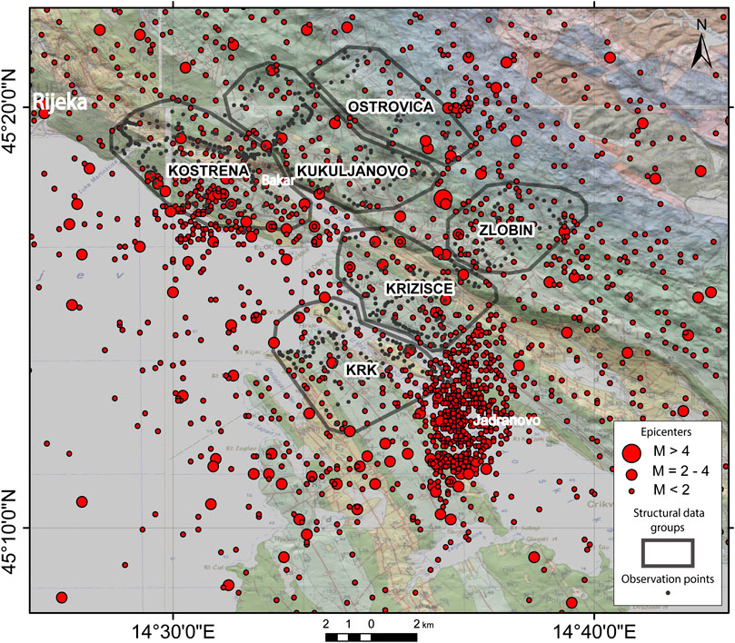
FIGURE 3. The investigated Bakar-Krk epicentral area. Red dots mark the most relevant instrumentally recorded earthquakes in the period 1979–2018 (M 0–3.6 and only one event M 4.5), showing the two recognized earthquake clusters in the areas of Kostrena and Jadranovo. Gray dots mark observation points in the area of the focused geological fieldwork while the 6 labeled irregular polygons mark spatial groups of structural data (see Results and Figure 6). The transparent geological map in the background is from the Basic geological maps of the area (Šikić et al., 1969; Šušnjar et al., 1970; Šikić et al., 1972; Savić and Dozet, 1985), which is underlain by a semitransparent hillshade map.
This paper presents a multidisciplinary approach to the definition of possible seismogenic faults that include classical geological and structural research on the surface, shallow seismic survey in marine area, and the focused 3D analyses of the selected hypocenters. The 3D modeling of the active faults is here for the first time applied in the area of External Dinarides, following the methodology developed on March 22, 2020, Zagreb earthquake sequence (Markušić et al., 2020). A combination of the results from the various methods allows us to narrow structures that could be active.
Data and Methods
Geological Mapping and Structural Analysis
For the purpose of interpretation of the near-surface geological structure, we mapped a few kilometers wide zones across the investigated area Bakar-Krk (Figure 3). The mapping was based on the lithostratigraphic units defined during the previous mapping of the neighboring islands (Fuček et al., 2015; Palenik et al., 2019). The objective of the geological mapping was lithostratigraphic harmonization of the existing Basic geological maps of the area in scale 1:100.000 that are based on chronostratigraphy and are not geologically harmonized in between the sheets (Šikić et al., 1969; Šušnjar et al., 1970; Šikić et al., 1972; Savić and Dozet, 1985). The new map is used for the interpretation of two representative geological cross sections approximately transversal to the main strike of the Dinaric structures (Figures 4, 5).
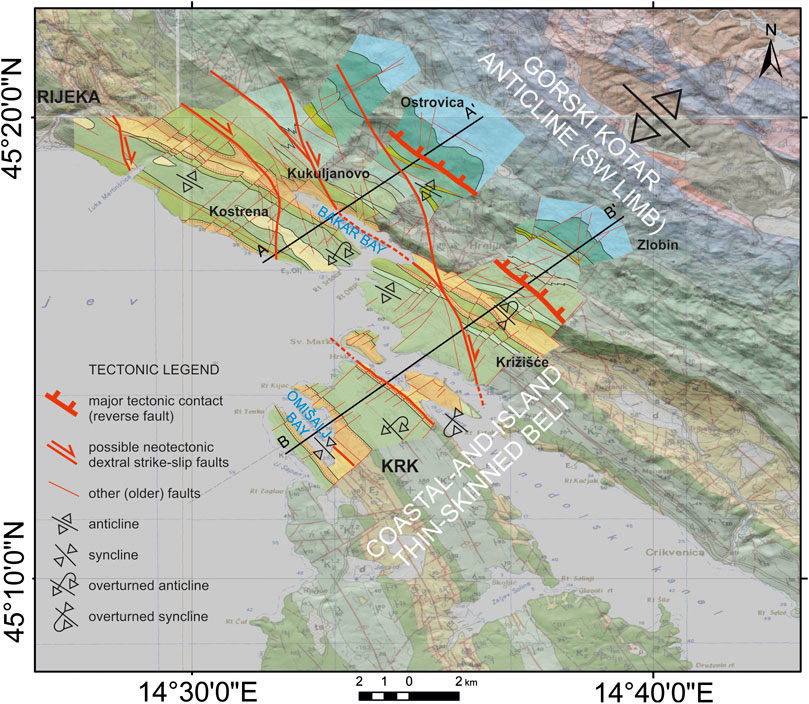
FIGURE 4. Simplified new geological map of the area of focused fieldwork (full-color overlay). The major fault (the thickest red lines) delineates the Gorski Kotar anticline and the coastal-and-island thin-skinned belt. Possible neotectonic dextral strike-slip faults on the surface are marked by medium-thick red lines and arrows. Position of the two representative geological cross sections A-A′ and B-B′ is indicated (Figure 5). The transparent map in the background is a compilation of the regional Basic geological maps (Šikić et al., 1969; Šušnjar et al., 1970; Šikić et al., 1972; Savić and Dozet, 1985) combined with a semitransparent hillshade.
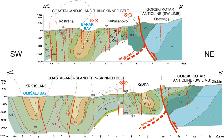
FIGURE 5. Representative transversal geological cross sections A-A′ and B-B′ (location map on Figure 4) show tightly folded early-orogenic coastal-and-island thin-skinned belt on the SW and the SW limb of the huge Gorski Kotar anticline on the NE. Major tectonic contact of the two zones, supposed early-orogenic detachment (cf. Korbar, 2009) and possible dextral neotectonic strike-slip faults are indicated. Abbreviations of the lithological units are after Fuček et al., 2015.
Structural-geological investigations of the area (Figure 3) were conducted simultaneously with the geological mapping. For the purpose of geological mapping, attention was given also to the detection of potentially active surface faults that are presumably marked by specific geomorphological features. The features were recognized on aerial orthophotographs using the public web map service (https://geoportal.dgu.hr/). The structural data are obtained by field measurements and include dip direction and dip angle of fault planes, orientation of carbonate slickensides defined by azimuth and plunge, and the sense of movement. The data are used for kinematic analyses and determination of fault kinematics in relation to the past stress fields.
During geological mapping and simultaneous structural field investigations, 315 fault plane data (Supplementary Tables) with all parameters required for kinematic analysis in the whole study area have been collected. The structural data are spatially grouped in six groups (areas) according to the position within the recognized general geological structures (Figures 3, 6). Based on kinematic criteria and sense of movements, the structural data were separated into main groups of faults and processed by Tectonics FP software (Ortner et al., 2002). Using the P–T-axis method (Marrett and Allmendinger, 1990), theoretical maximum (σ1), intermediate (σ2), and minimum stress axes (σ3) were calculated, whereas using the Right Dihedral Method (Angelier and Mechler, 1977), paleosynthetic focal mechanisms as representations of the paleostress fields for the analyzed faults were determined.
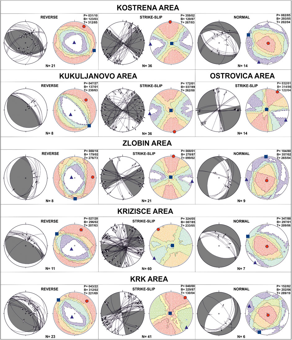
FIGURE 6. Structural diagrams for the faults of the investigated area (Supplementary Tables). The red dots, rectangles, and blue triangles indicate P, B, and T kinematics axes, respectively.
Seismological Analysis and 3D Modeling of the Active Faults
A fault plane solution (FPS), also called a focal-mechanism solution, is a simple way of studying the earthquake faulting process. Its goal is to determine the geometry and sense of motion on the fault. In this work, we analyzed the spatial distribution of the first P-wave motion polarities to obtain fault plane solutions for earthquakes recorded in the investigated area by the Croatian seismic network. The FPS from previous studies in the area (Markušić et al., 2019) and from earthquakes in Croatian source mechanism database (Archive of the Department of Geophysics) were updated with FPS calculated within this research for the study area and magnitudes M ≥ 2.7 (Figure 7). It should be noted that all events are weak-to-moderate earthquakes (M 2.7–4.5).
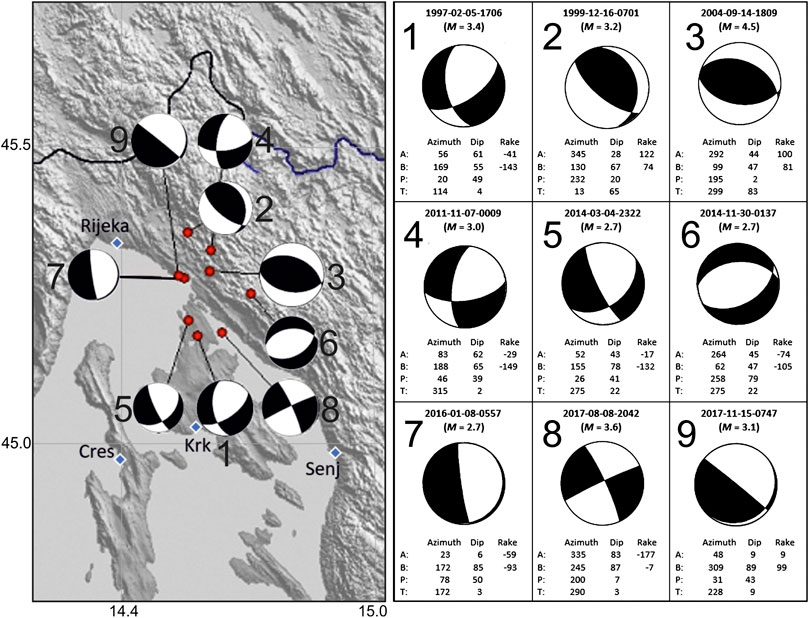
FIGURE 7. Focal mechanisms for the selected earthquakes (M ≥ 2.7) in the wider Bakar-Krk area and detailed information about the nine fault plane solutions (FPS) for the earthquakes (from the Croatian source mechanism database, an updated version of Markušić et al., 2019). Black areas on the lower focal hemisphere mark compression. Azimuth, Dip, and Rake mark the azimuth of the fault strike, fault dip, and movement direction along the fault plane. Relation of the FPS with possible active structures is shown in Figure 12.
A 3D analysis of the seismic activity in the considered area was based on the temporal and spatial distribution of the selected recent earthquakes (Figure 3). With the aim to analyze the most relevant seismological data (especially concerning the focal depth), only the instrumentally recorded earthquakes from the catalog from 1979 to 2018 were selected. Near-surface probably nontectonic events and the events automatically calculated to virtual infinity depth were eliminated. Because of the too large number of the hypocenters (Supplement 1), we focused on the two biggest earthquake clusters located east of the island of Krk (“Jadranovo” cluster) and west of Bakar (“Kostrena” cluster) (Figure 3), as well as to the coastal zone of the Dinaric strike along the Bakar-Vinodol flysch zone (Figure 1) that is interpreted previously as a major active thrust of the External Dinarides (Stiros and Moschas, 2012). Thus, the analysis is based on the hypocenters of the events that are relatively well located, considering the development of the quality and the increasing number of the instruments.
Seismological data provided the input for preliminary active faults modeling. The input data comprise recorded hypocenters including magnitude value, coordinates, depth, and the precise time of each shock for the earthquake sequences in the time span from 1979 to 2018 (Figure 3; Supplement 1). Most of the hypocenters dated from 2001 to 2017, due to gradual densification of the seismological grid in the wider area, while older data mostly represent significant seismic events holding relatively high magnitude values. The data was processed and represented spatially and temporally, including a time-lapse visualization using ESRI ArcSceneTM 10.2.1. Geological interpretation of the processed data included both spatial and temporal 3D visual analysis of the hypocenters. The methodology for extraction of hypocenters was based on visual extraction of hypocenters concentrated around a suggested specific fault plane. A total of 943 events were used for visual analysis and extraction of three datasets used for interpretation of the fault planes/zones. Selected datasets were used as input for the structural modeling of fault planes (Figure 8) performing the inverse distance weight (IDW) point interpolation method, using Move 2019.1 (cf. Markušić et al., 2020).
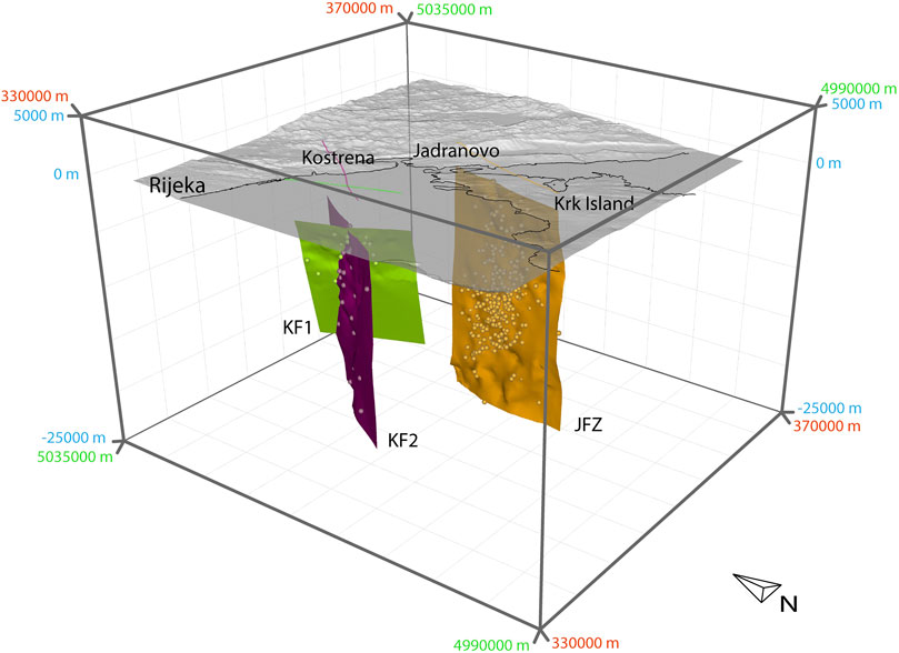
FIGURE 8. 3D model of the selected earthquake hypocenters and the interpreted fault planes in the area of Kostrena and Jadranovo (see also Supplement 2). Broken lines in the related color mark surface projections of the modeled faults (map of the epicenters and the faults is shown in Figure 12). Coordinate grid is HTRS96-TM. KF: Kostrena fault (1 and 2). JFZ: Jadranovo fault zone.
High-Resolution Shallow Seismic Survey
In order to detect possible (sub)recent faults or other evidence of tectonic activity in the marine environment, we conducted a high-resolution seismic reflection survey using an Innomar SES-2000 light. We chose the SES-2000 light as the most suitable, as it is a parametric subbottom profiler (SBP) designed for application at water depths down to 400 m, with sediment penetration up to 50 m (Wunderlich and Müller, 2003; Winton, 2020) and theoretical resolution of 5–10 cm (Daxer et al., 2019; Wang et al., 2019). It uses a high frequency for echo sounder and bottom track, and low frequency for subbottom data. Together with a high ping rate (up to 40 pings per second), it allows a good penetration and high resolution of collected data. Further technical information and advantages of this system in similar environments can be found in Wunderlich (2007), Missiaen et al. (2008), Unnithan and Rossi (2018), and Yutsis et al. (2014). During the survey, we used a low frequency of 6 or 8 kHz and a high frequency of 12 kHz. An SBP was side-mounted on a 6 m long shallow draught vessel with a low noise engine. For positioning and vessel motion corrections, we used Applanix POS MV WaveMaster combined with two Trimble GNSS antennas and RTK unit to receive corrections from CROPOS network (Croatian Positioning System). During the survey, the vessel speed was maintained at 3.5 knots. Processing and interpretation of seismic data were made in GeoSuite Allworks software. We acquired 65 acoustic profiles with a total length of 264 km (Figures 9, 10).
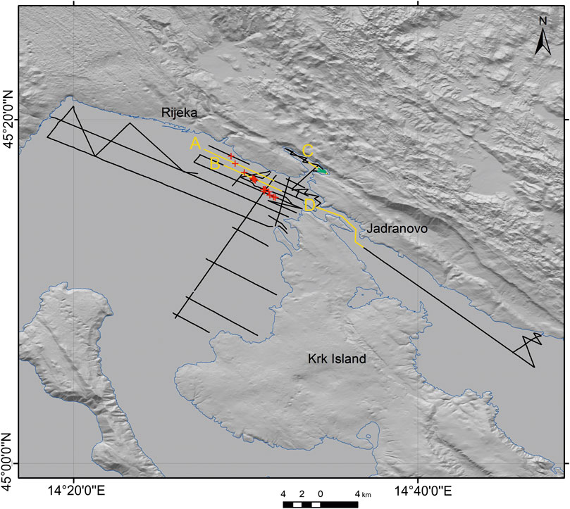
FIGURE 9. A map shows tracklines of high-resolution shallow seismic survey (black lines) with highlighted parts of the profiles presented in Figure 10 (yellow lines), recognized subbottom faults on the seismic sections projected to the surface (red crosses), and MTD, i.e., underwater landslide extent (green lines).
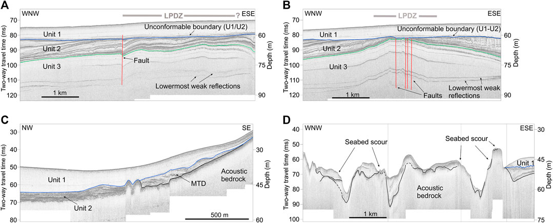
FIGURE 10. High-resolution seismic profiles showing (A) fault at the western margin of the Late Pleistocene deformation zone (LPDZ) in profile A-A′ in the Rijeka Bay; (B) multiple faults along the central part of the LPDZ in profile B-B′ in Rijeka Bay; (C) downslope mass-transport deposit (MTD i.e., underwater landslide) in the eastern part of the Bakar Bay; (D) seabed in the area south of Jadranovo scoured by bottom currents; signal penetration is weaker due to the coarser-grained sediment and shallow acoustically impermeable bedrock.
Results
Geological Cross Sections and Structural Analysis
Two geological cross sections are constructed along the mapped zones (Figures 4, 5). Both cross sections highlight the complexity of the near-surface geological structure in the investigated area. There are two main large-scale uppermost crustal geological structures: the strongly deformed coastal-and-island belt on the SW and the SW limb of the huge Gorski Kotar anticline on the NE. The coastal-and-island belt is characterized by tightly folded, faulted, and strongly fractured predominantly middle Cretaceous to Paleogene carbonates and some Paleogene clastic rocks (predominantly flysch). Such a structure is probably superimposed on the major detachment (master thrust fault) formed at rheologically weak horizon within the Lower Cretaceous succession during the Eocene thin-skin tectonic phase of the orogenic evolution of the External Dinarides (Korbar, 2009). The SW dipping south-western limb of the huge Gorski Kotar anticline is built of the relatively tectonically intact (well preserved) Jurassic to Lower Cretaceous carbonate rocks that further to the NE disconformably overlay Paleozoic to Triassic core of the anticline (Herak, 1980; Savić and Dozet, 1985). The contact of the huge Gorski Kotar anticline and the tightly folded coastal-and-island belt could be the major Oligocene thick-skin fault that dissected the primary thin-skin detachments (Korbar, 2009) although the detachment could be formed simultaneously with the formation of Gorski Kotar anticline along the major reverse fault (Figure 5).
The coastal-and-island belt is built of kilometer-scale asymmetrical, isoclinal, and overturned folds with amplitudes of up to 2 km, which imply a significant amount of horizontal shortening during the early-orogenic detachment folding (Figure 5; Korbar, 2009). The large NW-SE striking longitudinal geomorphological carbonate ridges generally mark anticlines. The Paleogene flysch rocks are partly eroded from the cores of the synclines and thus the synclines form distinct geomorphological valleys and elongated bays. A system of small NE-SW and NNW-SSE striking transversal faults insignificantly dissected the fold limbs and were probably formed as conjugated faults during the folding. The predominantly steep faults strike along the fold axes and in places dissect the axes along the NNW-SSE striking fault segments, implying that the steep faults are relatively younger than the folds itself (Oligocene-Miocene?). Thus, the steep faults have (inverse) sigmoidal appearance on the map, although there are only a few tens to few hundreds of meters offsets of the geological boundaries of the mapped units along the faults (Figure 4).
The analyses of the geological map and the orthophoto images revealed the selective erosion and increased weathering of carbonate rocks along the sigmoidal faults that could be a geomorphological expression of a possible neotectonic activity of the faults. Nevertheless, a braided system of relatively younger predominantly dextral strike-slip faults is recognized in the area (Figure 4).
The observed faults at the scale of individual outcrops in the investigated area are characterized by dip-slip, strike-slip, and oblique-slip kinematics. In each of the six selected study areas (Figure 3), fault data were divided into three main categories according to the sense of the movement: reverse, strike-slip, and normal faults (Figure 6).
Reverse faults on the outcrops in the whole investigated area are characterized by the NW-SE strike, dipping both toward the NE and the SW. The exception is the Ostrovica area where reverse faults are characterized generally by the N-S strike with dip direction to the E and the W. Reverse faults with NE-SW strike direction are relatively rare in the investigated area. Structural analysis of the representative paleostress field for the reverse faults indicates a compression associated with P-axis dominantly trending NE-SW, whereas the T-axis mostly dipping toward the SW. Some of the observed reverse fault planes were characterized by structural reactivation, with slickenside indicating different movements, since the reverse, normal, and horizontal movements are observed on the same fault planes.
Observed strike-slip faults (both dextral and sinistral) in the study area are characterized by steeply dipping geometry and a variety of strikes. However, there are three predominant strike directions of the strike-slip faults: NE-SW, N-S, and NW-SE, while E-W strike is relatively rare. Kinematic analysis shows that strike-slip faults of the Kostrena, Kukuljanovo, and Zlobin area formed or have been active in the paleostress field with the N-S trending P-axis. Strike-slip faults of the Ostrovica and Krk area associated with the NE-SW trending P-axis and the T-axis trending NW-SE, while strike-slip faults of the Križišće area are characterized by NW-SE trending P-axis and the T-axis trending NE-SW. Some of the mapped strike-slip fault planes were also characterized by structural reactivation, with slickenside indicating both dextral and sinistral movements.
Normal faults in the study area are also characterized by different strike direction. In the Kostrena and Križišće NW-SE strike predominates. These normal fault planes were formed within the paleostress field with a subvertical P-axis and the subhorizontal T-axis trending NE-SW, which suggested NE-SW directed extension. In the Zlobin area, normal fault planes are generally N-S striking and kinematic analysis indicated that these faults were formed within the paleostress field associated with the subvertical P-axis orientation 184/80 (dip direction/dip angle) and subhorizontal T-axis trending E-W, resulting in the E-W extension. In the Krk area, strike direction of normal fault planes is mostly NE-SW and kinematic analysis of this fault shows NW-SE directed extension.
Cross-cutting relationships between mapped reverse, strike-slip, and normal faults are not sufficiently determined during field observations; therefore, no conclusions can be made about their relative age relationship. However, the presented structural data indicate a polyphaser tectonic history of the investigated area.
Focal Mechanisms of Earthquakes in the Bakar-Krk Area
The fault plane solutions (FPS) in a relatively small investigated area cover a complete range of possible earthquake mechanisms (Figure 7). The reverse FPSs are oriented generally parallel to the Dinaric strike and the eastern Adriatic coast, while the FPSs of normal, oblique, and strike-slip faults indicate activity of a fault system aligned parallel and transversal to the strike. The principal tectonic stress in the area according to the FPS is generally NE-SSW.
3D Analyses of Seismologically Constrained Fault Planes
We tentatively examined the spatial distribution of the instrumentally recorded seismic events in the investigated area presuming that they all have tectonic origin and that the relatively short period events are related to their hosting structure (Figure 8; Supplements 1 and 2). Based on the selected datasets (Table 1), three faults were modeled using inverse distance weight (IDW) interpolation of the preselected datasets (see Data and Methods for explanations).

TABLE 1. A list of modeled active faults and an overview of input data (extracted hypocenters) used for the interpolation of the fault plains (the complete data are available upon request).
The largest dataset was analyzed in the Jadranovo area, where the hypocenters are clustered generally along a subvertical broad fault zone striking generally NNE-SSW. Hypocenters are located from a few down to 20 km (Table 1).
In the area of Kostrena, we interpreted two possible faults according to the analysis of the spatial and temporal occurrence of the selected earthquake clusters: Kostrena fault 1 (KF1) and Kostrena fault 2 (KF2). The KF1 has fault plane steeply dipping to the ENE and striking NNW-SSE (generally Dinaric strike) and is characterized by the hypocenters located in the middle depths. The KF2 is characterized by a subvertical fault plane striking generally NE-SW that is derived from middle-to-deep-seated hypocenters.
In the area of Bakar Bay and its hinterland, we were not able to select any spatially and temporally related cluster of hypocenters needed for the interpretation of possible active fault plane.
This preliminary approach of fitting hypocenter locations does not match well with the calculated focal mechanisms investigated in this paper (Figure 7) or with other more regional solutions. Thus, this is an attempt to see how different data fit together. We do not consider it representative at this stage and furthermore dedicated and detailed approach in modeling spatial seismicity patterns in possible active fault structures is needed.
High-Resolution Shallow Seismic Data
The trackline grid (Figure 9) was irregular with line separation from 200 m up to 4.3 km in an attempt to cover a larger area and detect as many tectonic deformation indicators as possible. Twenty-five profiles were oriented parallel to the coastline, while 12 were perpendicular.
Analyses of 264 km of shallow seismic images revealed that the acoustic signal penetration into the sediment was up to 39 m in Rijeka Bay (with sound velocity estimated at 1,500 m/s), with water depth down to 64 m. The sides of the Rijeka Bay are very steep and rocky, reaching depths of over 50 m approximately 500 m away from the coast. The rest of the bay has a flat and smooth bottom with sediment thickness larger than signal penetration. Recent fine-grained sediments (mud) predominantly cover the Rijeka Bay sea bottom (Juračić et al., 1999). Sediment distribution was influenced by sea-level changes that occurred during the Late Pleistocene (Benac and Juračić, 1998). As a consequence of fine-grained sediments, it was possible to achieve a good acoustic signal penetration in the Rijeka Bay. Penetration of the acoustic signal in the Mala Vrata and Vinodol Channel was up to 20 m but dominantly 5 m or less, not only due to the seabed consisting of gravel and sandy mud (Juračić et al., 1999), but also due to shallow depth to carbonate bedrock. Acoustic signal penetration in significantly shallower Bakar Bay (down to depth −38 m) is up to 20.5 m when it reaches acoustically impermeable bedrock.
The sedimentary sequence of the Rijeka Bay shown in the seismic profiles can be divided into three major seismic units (Figure 10). The upper seismic unit (Unit 1) is acoustically homogenous and semitransparent. Moderate-to-high amplitude and subparallel internal reflectors characterize the lower unit (Unit 2). Unit 1 and Unit 2 are separated with a high amplitude unconformity. The lowermost unit (Unit 3) exhibits subparallel reflectors with weak amplitudes.
Neotectonic deformation along the tracklines of the high-resolution seismic survey is recognized only in the NE corner of the Rijeka Bay (Figure 9). Gentle folding and decimeter-scale faulting within the Late Pleistocene stratified sediments are recognized within the Late Pleistocene deformation zone (LPDZ; Figures 9, 10). LPDZ is characterized by up to a few kilometers wide and up to 10 m high antiformal structures with internal gently undulating folds (hectometers wavelengths and meters amplitudes). Besides, faulting can be easily detected in multiple seismic profiles in the Rijeka Bay (Figure 10). As visible in selected seismic profiles (Figure 10), faults can be traced in acoustic unit with moderate-to-high amplitude and subparallel internal reflectors. The faults and folds cannot be traced in the upper acoustically semitransparent homogenous unit. The vertical offset of the strata along the fault is less than 25 cm. A fault direction is delineated in the map as point locations of the fault marked on the tracklines (Figure 9). A supposed fault line extends from the north of the bay (Kostrena) Closer to the Krk Island in the southeastern direction (Dinaric strike). Closer to the island of Krk, a fault divides into 2 or 3 possible fault lines that are part of the LPDZ.
Furthermore, a downslope mass-transport deposit (MTD, i.e., underwater landslide) was detected in the Bakar Bay. MTD unit is characterized in the seismic profiles by irregular upper reflector and chaotic internal structure (Figure 10C). The unit is overlain by acoustically homogenous and semitransparent upper unit (Unit 1). Its extent covers most of the farthest southeastern part of the Bakar Bay (Figure 10C). It can be traced on 3 profiles (Figure 10) and is delineated on the map (Figure 9).
Seismic profile between the Krk Island and the mainland, located in the Mala Vrata and Vinodol Channel (Figures 9, 10D), differs from profiles in the Rijeka Bay. The sea bottom is very irregular, with evident seabed scouring and carbonate bedrock reaching surface. Sediments that overlay carbonate bedrock are generally thin or absent due to the scouring in narrow channel. Southeastern end of the profile comprises thicker sediment succession as the channel widens and enables sedimentation. Detected sediments have low-to-medium amplitude reflectors due to the coarser grain size. Thus, there is no evidence of neotectonic movements on the seismic profiles in the Vinodol Channel.
Discussion
Indicators of Neotectonic Deformations in High-Resolution Shallow Seismic Data
Neotectonic deformations can be readily recognized in the Quaternary marine and lacustrine sediment successions, either as faults and folds within the stratified sediments or as secondary effects such as mass-transport deposits (MTDs, e.g., Strasser et al., 2011; Wiemer et al., 2015; Moernaut et al., 2017; Wright et al., 2019; and Ojala et al., 2019), i.e., underwater landslides. The recognition of such subsurface features in the investigated area (Figure 9) allows insights into the long-term neotectonic activity spanning the Late Pleistocene and Holocene.
The age and lithology of the recognized seismic units, at this moment, can only be assumed and correlated with other previously published studies (Juračić et al., 1998; Brunović et al., 2020) because of the lack of sediment cores collected in the Rijeka Bay. Accordingly, the lower seismic unit (Unit 2) can be interpreted as Late Pleistocene lacustrine/riverine sediments (Figure 10). The transition from the lower unit into the upper unit (marked with erosional surface with pronounced reflector) is interpreted as the Late Pleistocene to Holocene transition while the upper seismic unit (Unit 1) is interpreted as Holocene marine sediment.
Neotectonic movements are recognized in the Quaternary sediment succession only in the north-easternmost part of the Rijeka Bay along the Late Pleistocene deformation zone (LPDZ; Figure 10). The LPDZ is characterized by generally Dinaric strike (NW-SE), and the deformed Late Pleistocene stratified deposits are truncated at the top (eroded) and unconformably overlain by the undeformed Holocene marine sediments (Figure 10).
Possible secondary effects of the strong earthquakes caused by the activity of still unrecognized main seismogenic faults are MTDs in the eastern part of the Bakar Bay that could be deposited during the strong earthquake-induced local slope failures in the eastern part of the Bakar Bay. The slope failures are located along a recognized neotectonic fault (Figure 12), although the failures could be related also to nontectonic processes along the relatively steep flanks of the bay.
Since the recognized LPDZ was probably not active during the Holocene, it could be explained by the shifting of the activity of the orogen-parallel neotectonic faults recognized in the NW part of the same active fault zone Ilirska Bistrica-Rijeka-Vinodol-Senj (cf. Moulin et al., 2016; Figure 1B). It should be mentioned that the NW projection of the subbottom linear deformation zone runs across the town of Rijeka, the area characterized by the anthropogenic modifications that greatly impair access to the surface geological and geomorphological data. Even if the fault is active, the slow deformations along the zone cannot be easily recognized within the basement carbonate rocks exposed on the surface (Figure 4). However, the surface fault in the area of Rijeka belongs to the recognized sigmoidal fault system which could be related to the LPDZ. It is supposed that the seismologically modeled fault (KF1) could also be blind, since there are no subbottom deformations along the projection of the fault. Besides, the KF1 can be steeper near the surface and thus could fit the fault recognized on the shallow seismic images, although we show only a simple projection of the modeled fault according to the seismological data (Figure 12).
The fault running through flysch synclines on the island of Krk could be a SE continuation of the recognized subbottom fault within the LPDZ (Figure 12). However, the LPDZ does not have to be related to the underlying bedrock fault, although the zone is oriented predominantly along the strike of the Dinaric structures, since the uppermost Pleistocene succession could be detached either from the older Quaternary sediments or from the bedrock and deformed only above a possible shallow detachment. Ground shaking during strong prehistorical earthquakes could trigger the deformations in the Late Pleistocene stratified sediments. Unfortunately, acoustic signal of shallow seismic did not penetrate deep enough to reach neither older Pleistocene deposits nor the bedrock (Figure 10A).
Preexisting Tectonic Structures and the Active Faults
The presence of all major fault types: normal, reverse, and strike-slip faults, the large range in their orientations, and the determined structural reactivation on many of the fault planes measured on the surface imply that the investigated area has gone through several tectonic phases. This is also evident from the near-surface structures in the northeastern part of the Kvarner region (Figures 4, 5). It is assumed that a major detachment has been activated within the preorogenic Lower Cretaceous succession during the Eocene early-orogenic thin-skinned tectonic phase in the area and that the thin-skinned tectonic cover of the Adria was dissected by the inherited thick-skin faults during Oligocene to Neogene (Korbar, 2009). Thus, most of the faults formed during the main Dinaric tectonic phases could be later reactivated as a response to the shifting tectonic stress from SW-NE to S-N (Ilić and Neubauer, 2005; Žibret and Vrabec, 2016), resulting in rather complex present-day fault net (Figure 6).
The steep faults mapped along the strike of the kilometer-scale Dinaric folds have been probably formed during the late-orogenic transpression (Tari, 2002; Korbar, 2009). Besides, some of the steep faults are probably near-surface expression of the deep crustal active faults (Figure 8) that accommodate the tectonic escape in this part of the External Dinarides (Picha, 2002). Sigmoidal appearance of some of the possibly neotectonic strike-slip steep faults (Figure 12) could be interpreted as a shallow crustal expression of the deep crustal interaction of the active faults. Namely, the interaction of steep orogen-parallel (longitudinal) and the subvertical transversal deep active faults could result in the formation of sigmoidal (braided) arrangement of the reactivated preexisting upper crustal faults (Figure 4). However, the along-strike displacements of the geological boundaries along the sigmoidal faults are only a few tens to a hundred meters. Thus, the displacement could be related to the neotectonic (Quaternary) deep crustal interaction of longitudinal Dinaric presumably oblique-slip (KF1 on Figure 8; Moulin et al., 2016; Žibret and Vrabec, 2016) and transversal strike-slip faults (KF2 and JFZ on Figures 4, 8). The latter could belong to the inferred Kvarner fault zone (Korbar, 2009).
Since the measured surface faults on the outcrops (Figure 6) do not match strictly the fault plane solutions (FPS) calculated from the seismological data (Figure 7), it seems that both the past and the active tectonic processes are not unambiguous. Thus, the previously formed tectonic structure and the preexisting faults in the thin-skinned tectonic cover probably do not match the deep crustal active faults (Figure 12). The tectonic movements below the thin-skinned cover could be redistributed irregularly along the near-surface preexisting faults and fractures, and thus there are no clear surface expressions of the active faults.
The early-orogenic detachment is supposed in the subsurface of the coastal-and-island belt (Figure 5). Theoretically, the detachment in the present-day structural setting could act as the extensional one (Korbar, 2009). The normal faults could be driven by the gravitational collapse of the thin-skinned part of the uppermost crust that tectonically overlay presumably thick-skinned and possibly still slowly growing Gorski Kotar anticline along the system of deeper transpressional Dinaric faults (Figure 11). Accordingly, the near-surface structures and the preexisting faults mapped on the surface (Figure 4), formed during the main phases of the orogenic deformations, probably only partly take over the active tectonic movements along the deeper faults. However, further research is needed for a reliable evaluation of the hypothesis.
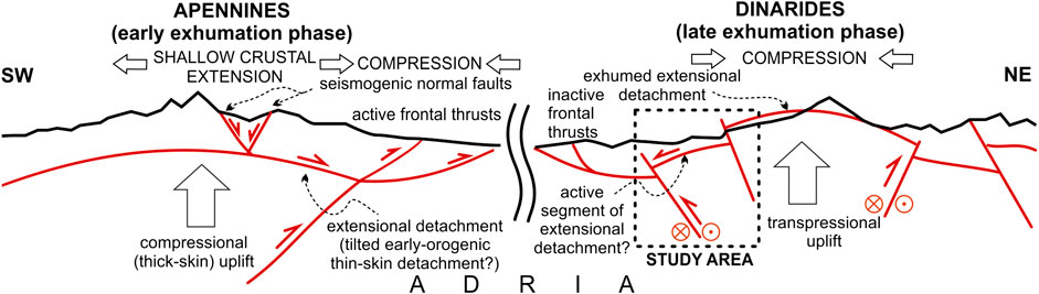
FIGURE 11. Comparison of the conceptual models of the present-day late-orogenic exhumation phases of the two Adria derived convergent fold-and-thrust belts: older the Dinarides and younger the Apennines.
The Apennines are similar but younger Alpine orogenic belt than the External Dinarides (Korbar, 2009), which is also characterized by a complex interaction of the thin-skinned and thick-skinned tectonics (Butler et al., 2004; Scrocca et al., 2005; Figure 11). In central Apennines, a regional almost aseismic extensional (gravitational) detachment is probably a driver for active shallow crustal normal faults that are well-known seismogenic sources of the destructive recent earthquakes in central Italy (Lavecchia et al., 2017). Seismologically weak compressional (transpressional?) thrusts are recognized below the extensional detachment at the midcrustal depths (> 20 km) where plastic deformations prevail (Finetti et al., 2001; Lavecchia et al., 2003). Thus, the thrusts could be related to the thick-skin orogenic exhumation, while the extensional detachments could be driven by the exhumational uplift of the orogen (Figure 11). The extensional detachments in the late-orogenic exhumation phase could be structurally rearranged (tilted) early-orogenic compressional detachments (master thrusts) that accommodated the thin-skinned tectonic deformations (cf. Korbar, 2009 for External Dinarides). In the External Dinarides, an older counterpart of the Apennines, the orogenic exhumation reached much shallower crustal levels, while possible seismogenic extensional detachments derived from the structurally rearranged (tilted) older thin-skinned compressional ones (cf. Korbar, 2009) could be exhumed along the crest of the External Dinarides (Figure 11). If so, transpressional deformations prevail in the upper crust of the highly exhumed External Dinarides, while the extensional tectonic events along the presumably active remnants of the extensional detachments are possible but probably rare (Figure 11).
Contribution to a New Seismotectonic Model of the Kvarner Region
The existing seismotectonic model of the Kvarner region is based on 2D interpretations of a simple projection of the selected hypocenters to the chosen cross section (Prelogović et al., 1995; Kuk et al., 2000). The model, among other data and analyses, is considered also for the analyses of the active seismogenic sources in the region (Kastelic and Carafa, 2012; Kastelic et al., 2013). However, 3D analyses of the local seismological and geological data are crucial for a reliable interpretation of the active faults. Thus, the preliminary 3D model of the seismologically constrained deeper crustal active faults (Figure 8) and the deformation zone interpreted according to the shallow seismic data from the marine realm (Figures 9, 10) are compared with the surface data (Figure 4), with the aim to make a more relevant insight into the possible active fault regime in the investigated area Bakar-Krk (Figure 12).
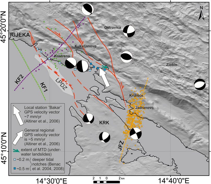
FIGURE 12. Summary map of neotectonic and active faults in the investigated area Bakar-Krk. Red lines mark neotectonic faults mapped on the surface (Figure 4) while broken red lines are their supposed submarine extensions. Shallow subbottom Late Pleistocene deformation zone (LPDZ) is marked by light gray area and the related fault zone by red crosses (see Figures 9, 10). Colored dotted lines are surface projections of the active structures (JFZ: Jadranovo fault zone; KF: Kostrena faults 1 and 2) modeled according to the selected hypocenters (see Figure 8). The related epicenters are marked by dots colored as the modeled faults. The focal mechanisms (FPS “beach-balls”) are for the selected earthquakes (M ≥ 2.7) in the wider Bakar-Krk area (see Figure 7 for details).
The majority of the earthquakes in the wider Rijeka epicentral area (Figure 2) are spatially distributed generally along the strike of the External Dinarides (NW-SE), i.e., along the fault zone Ilirska Bistrica–Rijeka–Vinodol that includes also the island of Krk (Prelogović et al., 1995; Kuk et al., 2000). The zone comprises also the investigated Bakar area (Figure 4) that is the NW continuation of the Vinodol fault zone (Palenik et al., 2019). The active NW-SE striking structure is regionally recognized as the transpressional Adriatic fault zone (Picha, 2002; Korbar, 2009; Figure 1C).
Many authors recognized active faults in the NW part of the External Dinarides, mostly in the SE Slovenia (Placer et al., 2010; Kastelic and Carafa, 2012; Kastelic et al., 2013; Moulin et al., 2016). Moulin et al. (2016) indicated three active faults some 50 km NW of Rijeka that are characterized by Dinaric strike and right-lateral displacement, and the active faults dissect the inactive older Dinaric thrusts. Faulting onset of the strike-slip Dinaric fault system in SE Slovenia occurred along the main fault during the Early Pliocene, while the transition from pure strike-slip to transpressive kinematics occurred during the early-middle Pleistocene. Besides, Moulin et al. (2016) found the evidence of successive activation of the parallel neighboring active faults, situated few kilometers on the south from the main fault.
The Late Pleistocene deformation zone (LPDZ) recognized on shallow seismic images in the NE part of the Rijeka Bay (Figure 12) is probably inactive and the activity of the related deformations could be shifted to another active fault recognized according to the seismological data. The surface projection of the fault strikes parallel to the LPDZ a few km SW (Kostrena fault 1 (KF1)). If the projection would be real, it would imply that a system of parallel faults is also active in this part of the External Dinarides, and that is characterized by a shifting activity successively along neighboring (reactivated?) faults striking along the External Dinarides (NW-SE, e.g., KF1 on Figure 12). Yet, none of the fault plane solutions (FPS) of the moderate earthquakes from the area strictly match the NE-dipping fault KF1, although there are the planes of a similar strike (Figure 12). It can be explained by the fact that only weak earthquakes that are too weak for a reliable calculation of the FPS occur along the active fault KF1. Besides, there is no recognized subsurface expression of the KF1 on the shallow seismic images of the Late Pleistocene layered sediments in that part of the Rijeka Bay (Figure 9). However, the Holocene vertical tectonic displacements could be too slow (Surić et al., 2014) to be recognized in Holocene marine sediments. Therefore, it is possible that during the Holocene ruptures occurred in this area but we do not have evidence in high-resolution shallow seismic data. An alternative explanation would be that LPDZ is not directly related to a bedrock fault but is a consequence of possible intraformational deformations because of possible strong prehistorical earthquake(s).
The instrumentally recorded seismicity in the wider Rijeka epicentral area allows analyses of only the last hundred years of the active tectonics in the region (Herak et al., 1996) while the reliable seismological data for the 3D modeling are available since 1979. It should be highlighted that historical locally destructive events occurred before the instrumental era (Herak et al., 2017). The GPS constrained ∼7 mm/yr NW movement of the point situated in the SE of the Bakar Bay does not match regional ∼5 mm/yr NE movement measured on other points from the Kvarner region (Altiner et al., 2006; Figure 1B). Besides, the extraordinary deep positions of the tidal notches along the southern coast of the Bakar Bay, which are ∼0.5 m deeper than all the other notches observed elsewhere in the investigated area (Benac et al., 2004; Benac et al., 2008), could be related to the strange GPS vector observed on the same tectonic block (Figure 12). The prehistorical underwater landslides in the eastern part of the bay could be related to strong earthquakes in the area. Although the deeper position of the notches is previously interpreted as a result of the downthrown footwall block of the major active thrust in the Bakar Bay (Stiros and Moschas, 2012), our results cannot confirm the thrust, and the fault responsible for the possible negative displacement could be also normal (gravitational?).
According to the results presented in our paper, none of the seismologically defined active faults have a distinct surface expression (Figure 12). The thin-skinned and highly deformed early-orogenic tectonic cover of the Adria is illustrated in Figures 5, 11. We supposed that active longitudinal and transversal faults dissect the Adria upper crust and cause brittle deformations and earthquakes down to approximately 20 km depths (Figure 9). Possible “blind” thrusts and strike-slip faults could be active below the thin-skinned tectonic cover of the Adria (Korbar, 2009). Since Adria is obviously generally moving to the north (Weber et al., 2010), a strain accumulated deeper in the crust is probably irregularly redistributed near the surface along the preexisting fault network formed during the earlier phases of the orogenesis. The discrepancy between seismologically constrained active faults and surface geology and geomorphology could be related to a complex shallow crustal anisotropy recognized generally also from the regionally differential attenuation of the seismic waves (Markušić et al., 2019). The sigmoidal strike of the generally orogen-parallel neotectonic near-surface possibly active faults (Figure 12) could be related to the interaction of the deeper crustal longitudinal and transversal faults recognized in the 3D model according to the seismological data (Figure 8, Supplement 1 and 2). The seismogenic fault slip could be in the uppermost crust redistributed along a rather complex network of longitudinal and transversal early-orogenic Dinaric faults (Figures 4, 6). Thus, the active faults modeled according to the seismological data probably have a minor expression on the surface and the earthquake clusters at Kostrena and Jadranovo could appear in the area of the interaction of the deeper crustal faults (Figure 12). On the overview tectonic maps, the two regional longitudinal and transversal fault zones could be generally recognized as the Northeast Adriatic and Kvarner fault zones, respectively (Korbar, 2009). However, the seismogenic faults along the zones are probably related only to the longitudinal earthquake zone Rijeka-Senj (Figure 2), since possible present-day activity along the transversal Kvarner fault zone is generally oriented parallel to the principal NE-SW present-day tectonic stress in the area (Figure 7), implying that the active faults must not be seismogenic. Thus, the geometry and position of the seismogenic faults responsible for the locally destructive historical earthquakes are still open.
The analyzed data did not allow recognition of any major seismogenic fault in the subsurface of the investigated area. However, the Dinaric reverse faults that in the present-day stress field probably act as the transpressional faults could be responsible for the major historical earthquakes (Figure 11). Yet, considering theoretical large-scale normal faulting above the structurally rearranged early-orogenic detachment that is supposed in this part of the External Dinarides (Korbar, 2009), there is also a possibility that seismogenic historical earthquakes resulting from possible large-scale gravitational displacements that are much less frequent than instrumentally recorded predominantly transpressional, reverse, oblique, and strike-slip events.
Thus, the historical strong earthquakes (Herak et al., 2017) could also be characterized by other mechanisms than instrumentally recorded. If so, the strongest historical events characterized by a centennial recurrence could be related to such an inferred kinematics that, along with the strong prehistorical tectonics recognized in the Late Pleistocene sediments, could represent a significant contribution to the long-term seismic hazard assessment for the wider Rijeka epicentral area. More than 350.000 inhabitants and the strategic National and central European infrastructure in the Rijeka area are the best motivation for further studies on the seismic hazard that partly should be based on the results of this research.
Open Questions and Future Research
Considering the open questions, further research is needed for relevant evaluation of the hypothesis. The research should be extended also onshore, when the high-resolution geomorphological data will be available. However, substantial anthropogenic modification significantly changed the geomorphology, as observed on orthophoto images of the key areas. Yet, focused detailed geomorphological analyses of a high-resolution digital elevation model could be useful for detection of possible small-scale surface ruptures. Quaternary deposits in the area are mostly preserved within the marine and lacustrine basins, and focused high-resolution bathymetric and shallow seismic survey is needed for a more precise definition of the recognized subbottom structures and for the detection of possible similar deformations in the areas that are not covered by the presented research.
Quaternary deposits onshore are relatively scarce, especially those of MIS 5e age that are often used as indicators of tectonic activity in other areas (e.g., Lambeck et al., 2004). Besides, possible Holocene deposits along the shorelines could be important for future studies on active tectonic. Furthermore, reported marine sediments onshore on the island of Krk should be reinvestigated (Marjanac et al., 1993). It would be useful also to focus on the microenvironmental influence on the morphology of the tidal notches that are regarded as geomorphological indicators of the vertical tectonic movements. It is especially important for specific marine environments such as the Bakar Bay that is characterized by the tidal notches at the lowest position with respect to the notches around the Kvarner Bay (Benac et al., 2004; Benac et al., 2008).
We have not addressed the alternative causes of the registered small-scale seismicity clustered along the subvertical transversal zones that are used for the 3D modeling of the active faults in the area. The strange orientation of the cluster and depth range from the subsurface to up to 25 km could be related also to the changes in the pore fluid conditions, influenced by larger-scale NW-SE oriented faults. Such fluid conduits, changes in the fluid recharge, and the related changes in the pore pressure can cause poroelastic stressing of the surrounding rocks leading to local stress perturbations and possible induced seismicity (e.g., Parotidis et al., 2003; Talwani et al., 2007). This may explain at least some of the registered events, but more detailed and structured work is needed for a more substantial interpretation.
Analyses of the GPS velocities at the carefully selected points that should be defined also according to the results of the presented research are crucial for future studies of the already generally recognized differential movements of the tectonic blocks in the area. Thus, GPS constrained movements of the specific points on both sides of the supposed neotectonic faults should be observed in future research.
All the aforementioned research could be performed during the interseismic period, while the unwanted but possible strong seismic events should be followed by the application of differential interferometric synthetic aperture radar technique or other up-to-date geodetic methods that can detect coseismic displacements along still undefined active faults in the wider Rijeka epicentral area.
Conclusion
In the investigated part of the Kvarner region (Bakar-Krk area), coastal-and-island belt is built of the kilometer-scale tightly folded preorogenic successions of Lower Cretaceous to Paleogene carbonates and flysch rocks. The tight folds appear probably above an early-orogenic thin-skinned detachment that was formed during the main tectonic phase in this part of the External Dinarides (Eocene). The thin-skinned belt is in a major tectonic contact with the huge Gorski Kotar anticline that could be considered as a contemporaneous or later thick-skin structure (Oligocene). The steep faults mapped along strike of the kilometer-scale Dinaric folds have been probably formed during the late-orogenic (Oligocene-Miocene) transpression. The presence of normal, reverse, and strike-slip faults, the large range in their orientations, and determined structural reactivation on many of the fault planes imply that the investigated area has gone through several tectonic phases of the long-lasting Alpine-type orogenesis that in the region resulted with the formation of the External Dinarides fold-and-thrust belt.
The calculated focal mechanisms of the moderate recent instrumentally recorded earthquakes in the investigated region imply the prevailing reverse deformation on generally NW-SE oriented faults, undetermined strike-slip solutions, and a few events also giving evidence for normal faulting along variously oriented planes. All of the solutions are generally compatible with the regional NE-SW oriented principal present-day stress direction and testify to a long-term convergent tectonic setting at the Adria-Eurasia margin.
The spatial and temporal distribution of hypocenters of the selected instrumentally recorded weak earthquake clusters indicate predominantly subvertical transversal (NE-SW and NNE-SSW) deep crustal active faults in the investigated area. Besides, a steeply NE-dipping active fault characterized by the Dinaric strike (NW-SE) is indicated as well.
The Adria moves generally northward, and a strain accumulating deeper in the crust could be released along the blind faults that have not a clear surface expression. The active tectonic movements deeper in the crust are probably irregularly redistributed near the surface along the preexisting fault net formed during the earlier phases of the orogenesis. Thus, the braided system of possibly active neotectonic steep faults characterized by a sigmoidal strike could be near the surface expression of the deep crustal interaction of the active longitudinal (orogen-parallel) and transversal faults in the area that probably accommodate the tectonic escape in this part of the External Dinarides.
In the northeastern part of the Rijeka Bay, the deformations in the Late Pleistocene stratified sediments could imply prehistorical activity of a fault characterized by the Dinaric strike (NW-SE). However, Holocene transgressive marine sediments are not deformed but unconformably overlay eroded Late Pleistocene deposits. The nearby parallel active fault modeled from the seismological data (KF1) could imply shifting of the tectonic activity among the neighboring faults in the investigated area, although the modeled fault could also be blind, since there are no subbottom deformations along the surface projection of the fault. However, the LPDZ does not have to be dissected by the underlying bedrock fault, since the uppermost Pleistocene succession could be detached either from the older Quaternary sediments or from the bedrock and deformed because of shaking caused by possible strong prehistorical earthquakes.
There are no distinct surface traces of the modeled active faults in the investigated part of the Kvarner region. Thus, the active faults in the coastal-and-island belt are possibly situated below the thin-skinned and highly deformed shallow crustal tectonic cover of the Adria. Regarding the supposed model, a new conceptual comparison of the late-orogenic evolution of the External Dinarides with the much better explored Apennines is presented.
Our aim is to create a robust inventory of multidisciplinary data that will be continuously updated and will serve for the purposes of identification and parametrization of active faults in the Kvarner region. Up to now, we populated it with data from focused geological mapping, shallow seismic profiles of the offshore sector, and the compilation of focal-mechanism solutions for relatively stronger earthquakes in the area and made a preliminary attempt in trying to fit the hypocenters of the recent relatively well-located events. While our results do not discuss the already established seismotectonic characteristics of the area, they on the other hand offer more details and possibly a clearer insight on the role of steep fault planes that seem to cut across the region along prevailing NW-SE oriented typical Dinaric geomorphological and geological features.
Data Availability Statement
The raw data supporting the conclusions of this article will be made available by the authors, without undue reservation.
Author Contributions
TK coordinated the multidisciplinary research and conceptually formatted the paper, provided a geological background and lead the interpretation of the results. SM performed the analysis of seismicity and prepared fault plane solutions for the selected events. OH and DB were responsible for high-resolution shallow seismic data acquisition and interpretation. LF coordinated the geological mapping and prepared geological cross sections. NB handled the spatial data, prepared the background maps and is responsible for the 3D fault modeling according to the selected hypocenters from the database. DP prepared the structural-geological analyses and contributed to the geological interpretations. VK contributed to the critical discussion on the regional seismotectonic setting and seismogenic sources and participated in the article writing and review. All the authors contributed to the paper in the parts related to their expertise and provided critical feedback for the discussion.
Conflict of Interest
The authors declare that the research was conducted in the absence of any commercial or financial relationships that could be construed as a potential conflict of interest.
Acknowledgments
This work has been supported by Croatian Science Foundation under the project GEOSEKVA (HRZZ IP-2016-06-1854) and partly is the result of training and education conducted through GeoTwinn project that has received funding from the European Union’s Horizon 2020 research and innovation program under grant agreement No. 809943. We thank to other members of GEOSEKVA geological mapping team: Vlatko Brčić, Marko Budić and Marko Špelić, for contribution to the fieldwork. We would like to thank to two anonymous reviewers and especially to the Editor Nathan Toke for very constructive suggestions used for improvement of an earlier version of the article.
Supplementary Material
The Supplementary Material for this article can be found online at: https://www.frontiersin.org/articles/10.3389/feart.2020.582797/full#supplementary-material
References
Acta Buccarana (1751–1763),. dokumenti za 1751–1763, signature A.91.196.174.276.663.; HR-HDA-21, Serije A, kutije 8, 10, 11 and 17, Hrvatski državni arhiv, Zagreb.
Altıner, Y., Bačić, Ž., Bašić, T., Coticchia, A., Medved, M., Mulić, M., et al. (2006). “Present day tectonics in and around the Adria plate inferred from GPS measurements.” in Postcollisional tectonics and magmatism in the Mediterranean region and Asia. Editors Y. Dilek and S. Pavlides (Boulder, CO: Geological Society of America Special Paper) 409, 43–55.
Anderson, H., and Jackson, J. (1987). Active tectonics of the adriatic region. Geophys. J. Int. 91, 937–983. doi:10.1111/j.1365-246x.1987.tb01675.x
Angelier, J., and Mechler, P. (1977). Sur une methode graphique de recherche des contraintes principales egalement utilisables en tectonique et en seismologie : la methode des diedres droits. Bull. Soc. Géol. Fr. 19, 1309‒1318. doi:10.2113/gssgfbull.S7-XIX.6.1309
Battaglia, M., Murray, M. H., Serpelloni, E., and Bürgmann, R. (2004). The Adriatic region: an independent microplate within the Africa-Eurasia collision zone. Geophys. Res. Lett. 31, L09605. doi:10.1029/2004GL019723
Benac, Č., and Juračić, M. (1998). Geomorphological indicators of the sea-level changes during upper Pleistocene (Wuerm) and Holocene in the Kvarner region. Acta Geograph. Croat. 33, 27–45.
Benac, Č., Juračić, M., and Bakran-Petricioli, T. (2004). Submerged tidal notches in the Rijeka Bay NE Adriatic Sea: indicators of relative sea-level change and of recent tectonic movements. Mar. Geol. 212, 21–33. doi:10.1016/j.margeo.2004.09.002
Benac, Č., Juračić, M., and Blašković, I. (2008). Tidal notches in Vinodol Channel and Bakar bay, NE Adriatic sea: indicators of recent tectonics. Mar. Geol. 248, 151–160. doi:10.1016/j.margeo.2007.10.010
Benjamin, J., Rovere, A., Fontana, A., Furlani, S., Vacchi, M., Inglis, R. H., et al. (2017). Late Quaternary sea-level changes and early human societies in the central and eastern Mediterranean Basin: an interdisciplinary review. Quat. Int. 449, 29–57. doi:10.1016/j.quaint.2017.06.025
Brunović, D., Miko, S., Hasan, O., Papatheodorou, G., Ilijanić, N., Miserocchi, S., et al. (2020). Late Pleistocene and holocene paleoenvironmental reconstruction of a drowned karst isolation basin (lošinj channel, NE adriatic sea). Palaeogeogr. Palaeoclimatol. Palaeoecol. 554, 109587. doi:10.1016/j.palaeo.2020.109587
Butler, R. W. H., Mazzoli, S., Corrado, S., De Donatis, M., Di Bucci, D., Gambini, R., et al. (2004). “Applying thick-skinned tectonic models to the Apennine thrust belt of Italy—limitations and implications,” in Thrust tectonics and hydrocarbon systems. Editor K. R. McClay (AAPG Memoir), Vol. 82, 647–667.
Correggiari, A., Roveri, M., and Trincardi, F. (1996). Late Pleistocene and holocene evolution of the north Adriatic sea. II Quaternario. 9, 697–704.
Cunningham, D., Grebby, S., Tansey, K., Gosar, A., and Kastelic, V. (2006). Application of airborne LiDAR to mapping seismogenic faults in forested mountainous terrain, southeastern Alps, Slovenia. Geophys. Res. Lett. 33, L20308. doi:10.1029/2006GL027014
Daxer, C., Sammartini, M., Molenaar, A., Piechl, T., Strasser, M., and Moernaut, J. (2019). Morphology and spatio-temporal distribution of lacustrine mass-transport deposits in Wörthersee, Eastern Alps, Austria. Geol. Soc. Spec. Pub. 500, 235–254. doi:10.1144/SP500-2019-179
Finetti, I. R., Boccaletti, M., Bonini, M., Del Ben, A., Geletti, R., Pipan, M., et al. (2001). Crustal section based on CROP seismic data across the north tyrrhenian-northern apennines-adriatic sea. Tectonophysics 343, 135–163. doi:10.1016/s0040-1951(01)00141-x
Fuček, L., Matičec, D., Vlahović, I., Oštrić, N., Prtoljan, B., Korolija, B., et al. (2015). Osnovna geološka karta republike hrvatske mjerila 1:50.000–list cres i lošinj (basic geological map of the Republic of Croatia 1:50.000 scale–cres and lošinj sheet). Zagreb, Croatia: Hrvatski geološki institut, Zavod za geologiju.
Gratianus, X. (1755). De usu Mercurii tam externe quam interne usurpati: observationes medico-practicae cum animadversionibus et ad calcem epicrisis. Viennae Austriæ MDCCLV Ex typographia Kaliwodiana, 179.
Gülerce, Z., Šalić, R., Kuka, N., Markušić, S., Mihaljević, J., Kovačević, V., et al. (2017). Seismic hazard maps for the western balkan. Environ. Eng. 4 (1), 7–17.
Herak, M., Herak, D., and Markušić, S. (1996). Revision of the earthquake catalogue and seismicity of Croatia, 1908?1992. Terra. Nova. 8, 86–94. doi:10.1111/j.1365-3121.1996.tb00728.x
Herak, D., Sović, I., Cecić, I., Živčić, M., Dasović, I., and Herak, M. (2017). Historical seismicity of the Rijeka region (northwest external Dinarides, Croatia)-Part I: earthquakes of 1750, 1838, and 1904 in the bakar epicentral area. Seismol. Res. Lett. 88, 904–915. doi:10.1785/0220170014
Herak, M. (1980). Sustav navlaka između Vrbovskog i Delnica u Gorskom kotaru (The nappe-system between Vrbovsko and Delnice in Gorski kotar (Croatia). Acta Geol. 10/2, 35–51.
HGI (2009). Geological map of the Republic of Croatia in scale 1:300.000. Available at: http://webgis.hgi-cgs.hr/gk300/default.aspx (Accessed July, 15, 2020).
Ilić, A., and Neubauer, F. (2005). Tertiary to recent oblique convergence and wrenching of the Central Dinarides: constraints from a palaeostress study. Tectonophysics 410, 465–484. doi:10.1016/j.tecto.2005.02.019
Ivančić, I., Herak, D., Markušić, S., Sović, I., and Herak, M. (2006). Seismicity of Croatia in the period 2002–2005. Geofizika 23, 87–103.
Ivančić, I., Herak, D., Herak, M., Allegretti, I., Fiket, T., Kuk, K., et al. (2018). Seismicity of Croatia in the period 2006–2015. Geofizika 35, 69–98. doi:10.15233/gfz.2018.35.2
Juračić, M., Benac, Č., and Crmarić, R. (1999). Seabed and surface sediments map of the kvarner bay, adriatic sea, Croatia (lithological map, M 1:500,000). Geol. Croat. 52, 131–140. doi:10.4154/GC.1999.11
Juračić, M., Crmarić, R., and Benac, Č. (1998). “Holocenski sedimenti i sedimentacija u Riječkom zaljevu,” in: Prirodoslovna istraživanja riječkog područja. Prirodoslovna biblioteka. Editors M. Arko-Pijevac, M. Kovačić and D. Crnković (Prirodoslovni muzej Rijeka), 1, 339–344.
Kastelic, V., and Carafa, M. M. C. (2012). Fault slip rates for the active External Dinarides thrust-and-fold belt. Tectonics 31, TC3019. doi:10.1029/2011TC003022
Kastelic, V., Vannoli, P., Burrato, P., Fracassi, U., Tiberti, M. M., and Valensise, G. (2013). Seismogenic sources in the adriatic domain. Mar. Petrol. Geol. 42, 191–213. doi:10.1016/j.marpetgeo.2012.08.002
Kišpatić, M. (1891). Šesto i sedmo izvješće potresnoga odbora za godine 1888.-1889. Rad Jugoslavenske akademije znanosti i umjetnosti. Matematičko-prirodoslovni razred, 11.
Korbar, T. (2009). Orogenic evolution of the external Dinarides in the NE adriatic region: a model constrained by tectonostratigraphy of upper cretaceous to Paleogene carbonates. Earth Sci. Rev. 96, 296–312. doi:10.1016/j.earscirev.2009.07.004
Kuk, V., Prelogović, E., and Dragičević, I. (2000). Seismotectonically active zones in the dinarides. Geol. Croat. 53 (2), 295–303. doi:10.4154/GC.2000.06
Lambeck, K., Antonioli, F., Anzidei, M., Ferranti, L., Leoni, G., Scicchitano, G., et al. (2011). Sea level change along the Italian coast during the Holocene and projections for the future. Quat. Int. 232, 250–257. doi:10.1016/j.quaint.2010.04.026
Lambeck, K., Antonioli, F., Purcell, A., and Silenzi, S. (2004). Sea-level change along the Italian coast for the past 10,000yr. Quat. Sci. Rev. 23, 1567–1598. doi:10.1016/j.quascirev.2004.02.009
Laszowski, E. (1923). Gorski kotar i Vinodol. Zagreb, Croatia: Matica Hrvatska, Tiskara “Narodnih novina”, 264.
Lavecchia, G., Boncio, P., and Creati, N. (2003). A lithospheric-scale seismogenic thrust in central Italy. J. Geodyn. 36, 79–94. doi:10.1016/s0264-3707(03)00040-1
Lavecchia, G., Adinolfi, G. M., de Nardis, R., Ferrarini, F., Cirillo, D., Brozzetti, F., et al. (2017). Multidisciplinary inferences on a newly recognized active east-dipping extensional system in Central Italy. Terra. Nova. 29, 77–89. doi:10.1111/ter.12251
Marjanac, L., Poje, M., and Marjanac, T. (1993). Pleistocene marine and terrestrial sediments with striata fauna on the island of Krk. Rad. Hrvat. Akad. Znan. Umjet. 463, 49–62.
Markušić, S., Stanko, D., Korbar, T., and Sović, I. (2019). Estimation of near-surface attenuation in the tectonically complex contact area of the northwestern External Dinarides and the Adriatic foreland. Nat. Hazards Earth Syst. Sci. 19, 2701–2714.
Markušić, S., Stanko, D., Korbar, T., Belić, N., Penava, D., and Kordić, B. (2020). The Zagreb (Croatia) M5.5 earthquake on 22 March 2020. Geosciences 10, 252. doi:10.3390/geosciences10070252
Marrett, R., and Allmendinger, R. W. (1990). Kinematic analysis of fault-slip data. J. Struct. Geol. 12, 973–986. doi:10.1016/0191-8141(90)90093-E
Missiaen, T., Slob, E., and Donselaar, M. E. (2008). Comparing different shallow geophysical methods in a tidal estuary, Verdronken Land van Saeftinge, Western Scheldt, The Netherlands. Neth. J. Geosci. 87 (2), 151–164. doi:10.1017/s0016774600023192
Moernaut, J., Van Daele, M., Strasser, M., Clare, M., Heirman, K., Viel, M., et al. (2017). Lacustrine turbidites produced by surficial slope sediment remobilization: a mechanism for continuous and sensitive turbidite paleoseismic records. Mar. Geol. 384, 159–176. doi:10.1016/j.margeo.2015.10.009
Moulin, A., Benedetti, L., Rizza, M., Jamšek Rupnik, P., Gosar, A., Bourlès, D., et al. (2016). The Dinaric fault system: large-scale structure, rates of slip, and Plio-Pleistocene evolution of the transpressive northeastern boundary of the Adria microplate, Tectonics 35, 2258–2292. doi:10.1002/2016TC004188
Nocquet, J.-M., and Calais, E. (2004). Geodetic measurements of crustal deformation in the western mediterranean and Europe. Pure Appl. Geophys. 161, 661–681. doi:10.1007/s00024-003-2468-z
Ojala, A. E. K., Mattila, J., Hämäläinen, J., and Sutinen, R. (2019). Lake sediment evidence of paleoseismicity: timing and spatial occurrence of late- and postglacial earthquakes in Finland. Tectonophysics 771, 228–227. doi:10.1016/j.tecto.2019.228227
Oldow, J. S., Ferranti, L., Lewis, D. S., Campbell, J. K., D'Argenio, B., Catalano, R., et al. (2002). Active fragmentation of Adria, the north African promontory, central Mediterranean orogen. Geology 30, 779–782. doi:10.1130/0091-7613(2002)030<0779:afoatn>2.0.co;2
Ortner, H., Reiter, F., and Acs, P. (2002). Easy handling of tectonic data: the programs TectonicVB for mac and TectonicsFP for windows. Comput. Geosci. 28, 1193–1200. doi:10.1016/s0098-3004(02)00038-9
Palenik, D., Matičec, D., Fuček, L., Matoš, B., Herak, M., and Vlahović, I. (2019). Geological and structural setting of the Vinodol Valley (NW Adriatic, Croatia): insights into its tectonic evolution based on structural investigations. Geol. Croat. 72, 179–193. doi:10.4154/gc.2019.13
Parotidis, M., Rothert, E., and Shapiro, S. A. (2003). Pore‐pressure diffusion: a possible triggering mechanism for the earthquake swarms 2000 in Vogtland/NW‐Bohemia, central Europe. Geophys. Res. Lett. 30 (20), 2075. doi:10.1029/2003GL018110
Perrey, A. (1850). Memoire sur les tremblements de terre ressentis dans la Peninsule turco-hellenique et en Syrie, Mémoires couronnées et mémoires des savants etrangers. Bruxelles, Belgium: Publiées par l’Académie royale, XXIII.
Picha, F. J. (2002). Late orogenic strike-slip faulting and escape tectonics in frontal Dinarides-Hellenides, Croatia, Yugoslavia, Albania and Greece. AAPG Bull. 86 (9), 1659–1671. doi:10.1306/61EEDD32-173E-11D7-8645000102C1865D
Placer, L., Vrabec, M., and Celarc, B. (2010). The bases for understanding of the NW Dinarides and Istria Peninsula tectonics. Geologija 53, 55–86. doi:10.5474/geologija.2010.005
Prelogović, E., Kuk, V., Jamičić, D., Aljinović, B., and Marić, K. (1995). “Seizmotektonska aktivnost Kvarnerskog područja.” in Proceedings of the first Croatian geological congress. Editors I. Vlahović, I. Velić and M. Šparica (Opatija, Croatia:Croatian Geological Society and Institute of Geology), Vol. 2, 487–490.
Radics, P. (1903). Geschichtliche Erinnerungen an das grosse Erdbeben in Fiume im Jahre 1750. Sonderabdruck aus der Monatsschrift „Die Erdbebenwarte“, Nr. 11 and 12, II. Jahrg., 1–7, Laibach, Druck von Ig. v. Bamberg, Germany: Kleinmayr and Fed.
Savić, D., and Dozet, S. (1985). “Osnovna geološka karta SFRJ 1: 100.000: list delnice (basic geological map of SFRY: sheet delnice) L 33-90.” in Geološki zavod; OOUR za geologiju i paleontologiju, Zagreb; Geološki zavod, Ljubljana (1970.-1983). Beograd, Serbia: Savezni geološki institut.
Schmid, S. M., Bernoulli, D., Fügenschuh, B., Matenco, L., Schefer, S., Schuster, R., et al. (2008). The Alpine-Carpathian-Dinaridic orogenic system: correlation and evolution of tectonic units. Swiss J. Geosci. 101, 139–183. doi:10.1007/s00015-008-1247-3
Scrocca, D., Carminati, E., and Doglioni, C. (2005). Deep structure of the southern Apennines, Italy: thin skinned or thick-skinned? Tectonics 24 (3), 1–20. doi:10.1029/2004TC001634
Šikić, D., Polšak, A., and Magaš, N. (1969). Osnovna geološka karta SFRJ 1:100.000, list crikvenica (basic geological map of SFRY 1:100.000 scale, crikvenica sheet) L 33‒101. Inst. Geol. Istraž. Zagreb (1958–1967). Beograd, Serbia: Sav. geol. zavod.
Šikić, D., Pleničar, M., and Šparica, M. (1972). Osnovna geološka karta SFRJ 1:100.000, list Ilirska Bistrica (basic geological map of SFRY 1:100.000 scale, Ilirska Bistrica sheet) L 33‒89. Inst. Geol. Istraž. Zagreb (1958–1967). Beograd, Serbia: Sav. geol. zavod.
Stipčević, J., Herak, M., Molinari, I., Dasović, I., Tkalčić, H., and Gosar, A. (2020). Crustal thickness beneath the Dinarides and surrounding areas from receiver functions. Tectonics 39, e2019TC005872. doi:10.1029/2019TC005872
Stiros, S. C., and Moschas, F. (2012). Submerged notches, coastal changes and tectonics in the Rijeka area, NW Croatia. Mar. Geol. 329–331, 103–112. doi:10.1016/j.margeo.2012.10.005
Strasser, M., Moore, G., Kimura, G., Kopf, A., Underwood, M., and Guo, J. (2011). Slumping and mass transport deposition in the Nankai fore arc: evidence from IODP drilling and 3D reflection seismic data. Geochem. Geophys. Geosyst. 12–15. doi:10.1029/2010GC003431
Šumanovac, F., Markušić, S., Engelsfeld, T., Jurković, K., and Orešković, J. (2017). Shallow and deep lithosphere slabs beneath the Dinarides from teleseismic tomography as the result of the Adriatic lithosphere downwelling. Tectonophysics 712–713, 523–541. doi:10.1016/J.Tecto.2017.06.018
Surić, M., Juračić, M., Horvatinčić, N., and Krajcar Bronić, I. (2005). Late Pleistocene-Holocene sea-level rise and the pattern of coastal karst inundation: records from submerged speleothems along the Eastern Adriatic Coast (Croatia). Mar. Geol. 214, 163–175. doi:10.1016/j.margeo.2004.10.030
Surić, M., Korbar, T., and Juračić, M. (2014). Tectonic constraints on the late Pleistocene-Holocene relative sea-level change along the north-eastern Adriatic coast (Croatia). Geomorphology 220, 93–103. doi:10.1016/j.geomorph.2014.06.001
Šušnjar, M., Bukovac, J., Nikler, L., Crnolatac, I., Milan, A., Šikić, D., et al. (1970). Osnovna geološka karta SFRJ 1:100.000, list crikvenica (basic geological map of SFRY 1:100.000 scale, crikvenica sheet) L 33‒102. Inst. Geol. Istraž. Zagreb (1961–1969). Beograd, Serbia: Sav. geol. zavod.
Talwani, P., Chen, L., and Gahalaut, K. (2007). Seismogenic permeability,ks, J. Geophys. Res. 112, B07309. doi:10.1029/2006JB004665
Tari, V. (2002). Evolution of the northern and western Dinarides: a tectonostratigraphic approach, Stephan Mueller Spec. Publ. Ser. 1, 223–236. doi:10.5194/smsps-1-223-2002
Tomsich, V. (1886). “Notizie storiche sulla città di Fiume – cronologicamente svolte, Fiume,” in Stabilimento Tipo-Litografico di. Editor E. Mohovich 621. (in Italian).
Unnithan, V., and Rossi, A. P. (2018). Enigmatic holocene sand ridges: complex meandering to anastomosing bedforms in the North Sea (German Seabight). Geo Mar. Lett. 38, 417–428. doi:10.1007/s00367-018-0543-9
Wang, F., Dong, L., Ding, J., Zhou, X., Tao, C., Lin, X., et al. (2019). An experiment of the actual vertical resolution of the sub-bottom profiler in an anechoic tank. Arch. Acoust. Q. 44 (1), 185–194. doi:10.24425/aoa.2019.126364
Weber, J., Vrabec, M., Pavlovčič-Prešeren, P., Dixon, T., Jiang, Y., and Stopar, B. (2010). GPS-derived motion of the Adriatic microplate from Istria Peninsula and Po Plain sites, and geodynamic implications. Tectonophysics 483, 214–222. doi:10.1016/j.tecto.2009.09.001
Wiemer, G., Moernaut, J., Stark, N., Kempf, P., De Batist, M., Pino, M., et al. (2015). The role of sediment composition and behavior under dynamic loading conditions on slope failure initiation: a study of a subaqueous landslide in earthquake-prone South-Central Chile. Int. J. Earth Sci. 104, 1439–1457. doi:10.1007/s00531-015-1144-8
Winton, T. (2020). “Quantifying depth of burial and composition of shallow buried archaeological material: integrated sub-bottom profiling and 3D survey approaches,” in 3D recording and interpretation for maritime archaeology McCarthy, J. K., Benjamin, J., Winton, T., and van Duivenvoorde, E. (Springer Coastal Research Library), 31, 154–174.
Wright, V., Hornbach, M., Brown, L., McHugh, C., and Mitchell, S. (2019). Neotectonics of southeast Jamaica derived from marine seismic surveys and gravity cores. Tectonics 38, 4010–4026. doi:10.1029/2019tc005806
Wunderlich, J., and Müller, S. (2003). High-resolution sub-bottom profiling using parametric acoustics. Int. Ocean Syst. 7 (4), 6–11.
Wunderlich, J. (2007). Mobile parametric sub-bottom profiler system for shallow and medium depth applications. J. Acoust. Soc. Am. 122, 2983. doi:10.1121/1.2942638
Yutsis, V., Krivosheya, K., Levchenko, O., Lowag, J., León Gómez, H. d., and Tamez Ponce, A. (2014). Bottom topography, recent sedimentation and water volume of the Cerro Prieto Dam, NE Mexico. Geofisc. Int. 53, 27–38. doi:10.1016/s0016-7169(14)71488-6
Žibret, L., and Vrabec, M. (2016). Paleostress and kinematic evolution of the orogeny-parallel NW–SE striking faults in the NW External Dinarides of Slovenia unraveled by mesoscale fault-slip data analysis. Geol. Croat. 69/3, 295–305. doi:10.4154/gc.2016.30
Keywords: Adriatic microplate, External Dinarides fold-and-thrust belt, earthquakes, active tectonics, geological mapping, Quaternary sediments
Citation: Korbar T, Markušić S, Hasan O, Fuček L, Brunović D, Belić N, Palenik D and Kastelic V (2020) Active Tectonics in the Kvarner Region (External Dinarides, Croatia)—An Alternative Approach Based on Focused Geological Mapping, 3D Seismological, and Shallow Seismic Imaging Data. Front. Earth Sci. 8:582797. doi: 10.3389/feart.2020.582797
Received: 13 July 2020; Accepted: 06 October 2020;
Published: 25 November 2020.
Edited by:
Nathan Toke, Utah Valley University, United StatesReviewed by:
Gang Rao, Zhejiang University, ChinaFederico Pasquaré Mariotto, University of Insubria, Italy
Copyright © 2020 Korbar, Markušić, Hasan, Fuček, Brunović, Belić, Palenik and Kastelic. This is an open-access article distributed under the terms of the Creative Commons Attribution License (CC BY). The use, distribution or reproduction in other forums is permitted, provided the original author(s) and the copyright owner(s) are credited and that the original publication in this journal is cited, in accordance with accepted academic practice. No use, distribution or reproduction is permitted which does not comply with these terms.
*Correspondence: Tvrtko Korbar, dGtvcmJhckBoZ2ktY2dzLmhy