 Zhuoma Wende1
 Guangliang Hou
 Jingyi Gao
- 1School of Geographic Science, Qinghai Normal University, Xining City, China
- 2Academy of Plateau Science and Sustainability, Qinghai Normal University, Xining, China
The study of past global change is paramount to comprehending the present and future, as well as to better understand the mechanisms and influences of human–land interactions in a given region. The northeastern margin of the Qinghai–Tibetan Plateau has complex natural environments, sensitive to global change, and renowned for its long history of human occupancy. This makes it an ideal region for the study of anthropogenic impacts on the paleo-natural environment. This paper reconstructed the prehistoric temporal and spatial distribution of cultivated lands on the northeast margin of Qinghai–Tibetan Plateau, and analyzed the Dianziping pollen assemblage to disclose the anthropogenic impacts on the paleo-environment. The results demonstrated that around 4.3–4.0 cal ka BP, the rapid development of the Majiayao culture boosted the population to approximately 39,200 people, over 460 km2 of the land area was converted to cropland, concomitantly, evidence of tree pollen decreased significantly. This marked the earliest identification of anthropogenic impacts on vegetation through agricultural activity in this region. At 4.0–3.6 cal ka BP, the population appeared to have diminished in conjunction with the cultivated land area. Nevertheless, forested areas continued to decrease, primarily due to adverse climatic conditions, but, anthropogenic activities played an undeniable role. Dianziping profile demonstrated the existence of natural forest in the Hehuang Valley during Qijia cultural Period. There was also evidence for the occurrence of regional fire events, suggesting large-scale burning of land cover in the area. This further illustrates anthropogenic impacts. At 3.6–2.6 cal ka BP, populations reached approximately 61,300 people, coinciding with the peak of cropland expansion. Consequently, more of the natural vegetation were converted to crops, and the superimposed influences of farming and grazing aggravated the process of deforestation and vegetation succession. Likewise, deforestation during the historical period can be explained, mostly by human driven causes with limited influence from climatic factors. The extensive exploitation of forest and expansion of cropland consequently resulted in extensive land deterioration, leaving the region with forest islands scattered in less populated, mountainous regions.
Introduction
Understanding the temporal and spatial evolution of land use as well as the resulting implications for ecological systems from the past may contribute to our understanding of global change, human–land interactions, and sustainable land use (Gaillard et al., 2018). Since the Holocene, land use and cover change driven by anthropogenic activities, primarily cultivation and grazing, have profoundly influenced surface vegetation patterns, and even the entire terrestrial ecosystems that persisted until today, consequently, humans have changed the physical, ecological, and biological components of the Earth’s planetary systems (Goldewijk et al., 2007; Pielke et al., 2011; Zhang et al., 2012; Ellis et al., 2013; Gaillard et al., 2018; Fang et al., 2019). The extent to which human activities modified the palaeoecological environment may prove vital in explaining the current environmental conditions. As such, the study of the human dimensions of global change is considered an integral part of palaeoecological environmental research (Miehe et al., 2014).
The northeast margin of the Qinghai Tibet Plateau (QTP) is densely populated and extensively cultivated. Relative to the rest of the plateau, it receives more precipitation and experiences warmer temperature. Denisova, an argumentum prima facie for early human footprints on the QTP, actively demonstrates that hunter-gatherers occupied this part of the world from the late Pleistocene (Zhang et al., 2020a, b). The palaeo-anthropogenic impacts on the natural vegetation on the northeast margin of the QTP are not known in detail. Agriculture is widely considered to be one of the most striking impacts humans have exerted on the natural ecosystem (Pongratz et al., 2008). In the northeast margin of the QTP, the climate was relatively warm and humid during the mid-Holocene (Cheng et al., 2013; Li et al., 2014), and provided a suitable environment for the introduction of agriculture in the area (Dong et al., 2012). Farming tools, such as stone knives and axes have been excavated (Xie, 2002). Moreover, charred seeds of millet were discovered in the Majiayao cultural sites (Jia et al., 2013). These provide unquestionable evidence for the onset of cultivation in this area. The ways in which agriculture may have transformed the natural environment in this part of the world, have yet to be studied in depth.
Agriculture emerged following the hunting and gathering culture and developed rapidly over time (Harlan, 1971; Bellwood et al., 2005). Agricultural activities have been a driving force for humans to adapt and modify the environment (Edwards, 1991; Cavalli-Sforza et al., 1993). Palynological and archaeological evidence have been used to reconstruct past environments (Zhou et al., 2011; Wei H.-c. et al., 2020; Miehe et al., 2021). In Europe, land cover change in the form of cropland expansion, caused severe deforestation as early as approximately 7 cal ka BP (Lowe and Walker, 1997). Pongratz et al. (2008) reconstructed the spatial dispersion of global cultivated land and other past land usage using historical population data and modern land use patterns. The results indicated that broadleaf deciduous forests were severely affected by cropland expansion. Vitousek et al. (1997), found that terrestrial vegetation has been significantly altered by the rapid development of agriculture. Driven by sharp increases in human populations, over 30–50% of the Earth’s land cover has been converted into agricultural land. The development of ancient Chinese civilization is entangled with the emergence of agriculture. During the mid-Holocene, a shrinking of forests across much of China was concomitant with the patterns of human settlement and cropland expansion (Ren, 2000). In the western Loess Plateau, the Yangshao people started millet cultivation around 6.0 cal ka BP, which developed rapidly, forming a complex farming structure with a variety of crops. The amplified intensity of farming resulted in a decrease in shrub and grassland coverage in the Longdon area (Zhou et al., 2011). Owing to the human disturbance, the coniferous and broadleaf mixed forests cover decreased markedly after 4.6 cal ka BP (Li et al., 2012). Hou et al. (2012) reconstructed prehistoric cultivated land areas in the middle and lower reaches of the Yellow River based on prehistoric population estimations and prehistoric sites. The results indicated that cropland expansion reduced area of the pristine forests along the lower reaches of the Yellow River. Based on those studies, it is clear that cultivation has had extensive consequences for the natural environment. To what extent this process has played out on the northeast margin of QTP is largely unknown. By reconstructing the prehistoric cropland area using palynological and archaeological evidence, this paper attempts to describe the impacts of anthropogenic activity on the natural vegetation in the northeastern margin of the QTP. In particular, this paper draws attention on changes in forests, as forest ecosystems are crucial components of the carbon cycle, biodiversity conservation, soil maintenance, water conservation, and climate regulation. In summary, this paper aims to better explain bio-physical environmental changes resulting from human intervention and make a contribution to the fields of palaeoecology, paleoenvironment, and paleo-climate.
Study Area
Environmental Setting of the Study Area
The northeastern margin of QTP encompasses the eastern part of Qinghai Province, including the areas along the Huangshui River and upper reaches of the Yellow River from Tongde County to Xunhua County, as well as the Gonghe Basin (Figure 1). This subregion is an important transitional zone between the QTP and Loess Plateau, marking the boundary between the East Asia summer monsoon and the northwest arid region. It features mostly north-south-oriented, high mountains, deep and broad valleys, well-developed river terraces, and elevations ranging between 1,650 and 5,206 m above sea level. The region is climatically sensitive and ecologically vulnerable. It is classified as having a temperate-arid and semi-arid continental climate, with mean annual precipitation between 252 and 535 mm, and mean annual temperature between 3 and 8°C (Jia et al., 2019). The dominant biome in this area is temperate grassland with distinctive vertical zonality. This area is typical of the agropastoral areas where river terraces are densely cultivated and it has one of the highest rates of agricultural land use on the QTP. In spite of the fact that this region accounts for only 5.18% of the province’s total area, the population exceeds 70% of the province’s total. Cropland area accounts for 73% of that found in the province (Zhao, 2016).
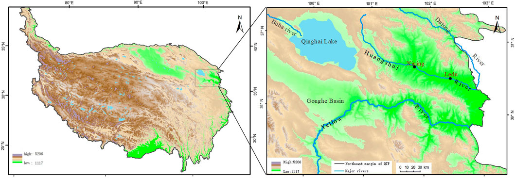
FIGURE 1. Northeast margin of the QTP. Scope of this study.
The Dianziping profile was collected from Gaomiao basin, Ledu County, Qinghai Province, which is characterized as having a temperate-plateau, semi-arid climate. The basin sits at an elevation of 1,870 m, has a mean temperature of 7.6°C and a mean precipitation of 333.7 mm annually. The Huangshui River runs through the basin from west to east. In the river valley, flat terrain and intact terraces are common. At present, cropland is widely distributed on terraces and slopes, and most of the plants observed in the valley are cultivated species such as Triticum aestivum, Vicia faba, Pisum sativum, Juglans regia, Zanthoxylum bungeanum, Populus, Salix, and others. In the foothills, temperate grasslands are dominant, with Stipa bungeana occurring as the dominating species; clustered Stipa glareosa and artemisia gmelinii are commonly observed. In the high mountains, shrub species such as Potentilla fruticosa, Salix oritrepha, Rhododendron lapponicum, and a few Picea crassifolia, Picea wilsonii are abundant. Mountain regions above 3,200 m are mainly Kobresia dominated alpine grassland.
Cultural Sequence
The scope of this study extends from the Neolithic Age to the historical time period (5.3–0.11 cal ka BP). This time frame coincides with the occurrence of the Majiayao, Qijia, Xindian, and the Kayue cultures. The Majiayao culture, renowned for its excellency in pottery, was centered in the Hehuang Valley and mainly practiced farming. Based on radiocarbon dating, the Majiayao culture can be categorized into three different subsets, the Majiayao type (5.3–4.5 cal ka BP), Banshan type (4.5–4.3 cal ka BP), and Machang type (4.3–4.0 cal ka BP). Around 4.2 cal ka BP, the Qijia culture (4.2–3.6 cal ka BP) replaced the Majiayao culture in the region, representing the onset of the Bronze Age. During the mid-late Bronze Age, people of the Kayue culture (3.6–2.7 cal ka BP), who practiced both farming and grazing, and the Xindian culture, which practiced farming, occupied the area. While the Kayue culture was mainly distributed in the western part of the study area, the Xindian Culture (3.6–2.6 cal ka BP) was found in the east (Xie, 2002; Chen et al., 2015).
Materials and Methods
Agricultural intensity is inherently linked to population density (Vasey, 1992; Pongratz et al., 2008). As such, population sizes can be used as a proxy for agricultural activity. To estimate the population, and analyze the spatial distribution pattern of cultivated land, the prehistorical sites in the northeast of QTP were examined here. The data for prehistoric sites were primarily obtained from the Atlas of Chinese Relics. More recent discoveries are also incorporated. The study area includes approximately 280 sites of the Majiayao type, 90 sites of the Ban Shan type, 520 sites of the Machang type, 430 sites of the Qijia Culture, 1,700 sites of the Kayue Culture, and 350 sites of the Xindian Culture (Bureau of National Cultural Relics, 1996; Zhang and Dong, 2017).
Population
Prehistoric population sizes are estimated mainly by settlement archaeology, grave analysis, bio-archaeology, relics study, and other analytical methods (Fang, 2007). In this study settlement archaeology and grave analysis were used for population estimation. Calculation of the prehistoric population was based on both the sizes of prehistoric sites (settlement archaeology) and the number of graves excavated at each site (grave analysis). In light of the fact that there were no record of prehistoric population and former studies of the specific human population, we used the data attained from officially excavated sites. Uncertainty around the population estimates are the result of inaccuracies in grave numbers due to both natural, and human disturbances such as grave robbery and village construction. These disturbances have resulted in an inaccurate number of recorded graves and excavated human bones. Consequently, the population estimates for this study are likely low, but provides a reasonable approximation of the population and general population growth trends, if used consistently across all sites.
Settlement Archeology
For the prehistoric sites identified within a specified area, settlement archaeology was used, and the following equation was adopted:
In this, Pi stands for the total population of the prehistoric site i; s represents the area size, and d provides the population density. Since the prehistoric population density of northeast QTP was unavailable, the prehistoric population density of the Yangshao culture (d = 0.005625 person/m2) was applied (Qiao, 2010). The Yangshao culture expanded to the east of QTP and established the early Majiayao culture. The sites of these two cultures were similar in terms of geographical settings; the Yangshao culture sites were located along the western fringe of the Loess Plateau which is connected to the northeast fringe of the QTP. Both sites exhibited similar climatic conditions as both were strongly influenced by continental monsoon and both cultures practiced millet farming. As such, the population density of the Yangshao culture was seemed applicable for estimating the population density of the Majiayao culture.
Grave Analysis
For the prehistoric sites with unspecified size area, grave analysis was adopted. The number of graves and human bones excavated at each typical cultural site was used as a reference for the total population of that particular cultural site. The life span, which was estimated from the study of human bones, was obtained from other studies (Table 1). Thus, the residential populations (annual population in a cultural site) for each cultural site were obtained using the following equation:
Here, Pri stands for the residential population of the site i: Pi gives the total population of the site i; Li is the estimated life span of the site i; Ti stands for the time span of the cultural site i (Table 1).

TABLE 1. Population and life span of each culture/type.
The total population of a cultural/type was estimated using the formula
The populations of all cultural sites with the same cultural types were summarized to obtain the total population (Pt) for each group.
Cultivated Land
The most distinct change in vegetation cover brought by anthropogenic activity is the conversion of natural to cultivated lands. The total area of the cropland can be used to estimate the extent of human disturbance to natural vegetation. Elevation, slope aspect, and gradient, as well as soil types, are considered as limiting factors for cultivation (Luo et al., 2015; Han et al., 2020). During the prehistoric time periods, the distance to the river was also considered a limiting factor for cultivation due to the lack of vehicles for transportation and undeveloped irrigation technology. Generally speaking, the suitable land area available for cultivation was limited by one social factor; population, and four natural factors; elevation, slope, water source, and soil type.
Natural Factors
Elevation, slope, water source, and soil type are considered the four natural factors affecting the suitability of cropland. Elevation greatly affects rainfall and temperature of the area. On the Tibetan Plateau precipitation and temperature are mostly at the edge of ecological limitation for forest. Slight elevation changes may lead to changes in the distribution of vegetation and even the entire ecosystem structure (Huang et al., 2008; Li D.-M. et al., 2008). Assuming that the topography of the prehistoric sites remained consistent with current landform, and millet was the main crop, three elevation zones were designated: 0–2,000 m, 2,000–2,800 m, >2,800 m. The high-altitude mountainous regions above 2,800 m are characterized by low temperatures, high precipitation, severe frost, low incidence of farming, and sparse vegetation cover (Zeng et al., 2012). They are, thus, considered unfavorable for cultivation. The major rivers along the settlement area provide a reliable water source for settlers within a 3 km or 1 h walking distance (Vita Finzi, 1969). Distance to a river (water source), in this case, has been identified as another limiting factor for cultivation. Slope gradient also greatly constrains the expansion of the cropland area (Han et al., 2020) and determines the potential for land erosion. It also influences the texture of the soil, and to an extent, the thickness of soil layers. A gradient of 20֯ is considered steep, prone to erosion, and hence, unsuitable for long-term cultivation (Li, 1978). The Tibetan Plateau is made up mostly of alpine desert and brown desert soil, which are not suitable for cultivation. Soil types that are suitable for cultivation, are relatively scarce. (Table 2).
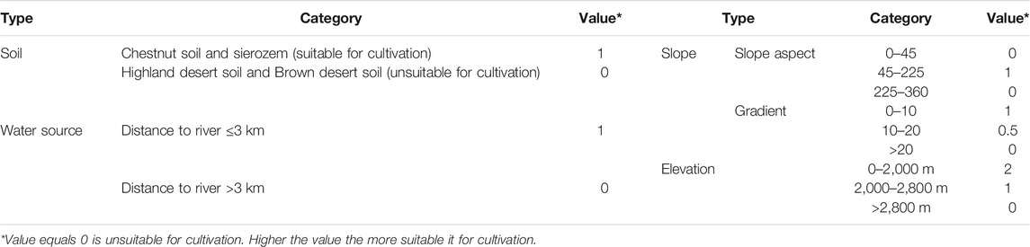
TABLE 2. Natural limiting factors in the reconstruction of cultivated farmland.
Social Factor: Population
The extent of arable land use is determined, in part, by the population of the area and mode of production employed (Chen Q. et al., 2019). In prehistoric times, a primitive method of cultivation was adopted whereby, land was burned prior to the planting of seeds. A similar strategy was also utilized during the Xia Dynasty and produced a grain yield of 37.5 kg/ha (Yang, 1998). The likeness in methodologies suggests that the grain production of the two may have been similar. The annual grain consumption of the Yangshao settlers was around 258 kg/person (Qiao, 2010), so, theoretically, the size of prehistorical cropland could be calculated through the following formula:
where Si stands for the theoretical size of cropland at prehistorical site i. Pi stands for the population size of the site i, and C stands for the grain consumption per person and Y stands for grain yield.
Estimates of the practical cropland area in use during each cultural time period were reconstructed using Arc-GIS. Assuming that cultivation would have taken place within a circle, with the prehistoric site in the center, the radius of the circle can be set as the measured range of cropland. The radius was based on the Si (site i theoretical cultivated land). Applying the buffer tool in Arc-GIS to that estimate, we obtained an approximation spatial distribution pattern of theoretical cropland area in each different culture. However, the distribution of cultivated land at any site is restricted by the natural factors of topography, as previously discussed. In areas where the sites are densely distributed, the actual cultivated land area may be smaller than that of the theoretical cultivated land area. The raster data was assessed again considering the natural limiting factors (Table 2). Areas were classified as; unsuitable (0–1) or more suitable (2–3) for crop cultivation. Superimposing the two estimated results and the new results ratings of three to four were considered to be practical for cropland area cultivated during the time period of a culture. In this way, the spatial distribution patterns and the sizes of practical cropland area for each culture were obtained. It is important to note that, during the Kayue cultural period, the mode of production was more diversified. Agriculture was the main subsistence strategy of the Kayue people living along the Yellow and Huangshui Rivers, but grazing and hunting supplemented their diets (Xie, 2002). The mean elevation of the Xindian sites is lower than that of the Kayue sites, thus the proportion of agriculture in the Xindian culture is higher than that of the Kayue culture. It follows that the grain in Xindian culture and Kayue culture accounts for approximately 80 and 60% of food consumption respectively. The radii for estimated cultivated land areas for the two cultures were approximately 535 and 320 m (rounded to the nearest five) respectively.
On-Site Profile for Pollen Analysis and Dating
A 3.5 m profile with intervals of 4 and 6 cm (280–311 cm) was collected from Dianziping (36°26′28″N, 102°34′51″E, 1,938 m.a.s.l.), Gaomiao basin for the purpose of dating and pollen analysis. Fifty samples were prepared according to standardized protocols and the experiment was carried out using standard procedures (Li et al., 1995). A known number of Lycopodium spores (27,637 ± 563 grain/slice) were added to each sample for calculating the values of pollen and charcoal concentration. Carbonate and silicate were removed with 10% hydrochloride and 40% hydrofluoric acid, respectively, and washed through 10 μm sieves. Five charcoal samples from the stratum were collected at depths of 108, 173, 194, 205, and 241 cm for AMS dating. These charcoal samples were sent to Quaternary Dating Laboratory for AMS14C dating in Peking University. Ages were calibrated using IntCal13 atmospheric curve (Reimer et al., 2013), using the program OxCal v4.2.4 (Bronk Ramsey, 2015).
Results
Population
Table 3 illustrates the population estimations of the different cultures. The Neolithic residential population size increased from 40 people in the early stages of the Majiayao culture to approximately 70 people during the Machang type. The residential population dropped to 50 people during the Qijia cultural period, but recovered during the Xindian cultural period and augmented to a similar rate of the Machang type. This indicates that, in spite of low population, the Xindian sites were more densely populated. The total population of the Majiayao type reached 9,900 people but fell by nearly half during the Banshan period. During the Machang type, the population increased dramatically and reached the peak of the Neolithic Age with a total population of 39,200 people in the northeast part of the QTP. Numbers decreased significantly during the Qijia cultural period and reached 22,790 people. The study area was occupied by both the Xindian culture and the Kayue culture during the mid-late Bronze Age when the total population reached approximately 61,330 people. Around 2.0 cal ka BP, during the Han dynasty, Zhao Chongguo, an official in Hehuang Valley, reported in his letter to the emperor, that there were about fifty thousand Qiangs (refers to the Kayue people) in the area. This supports the estimated results of the Kayue population.
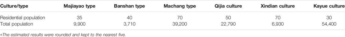
TABLE 3. The estimated result of population.
Cultivated Land
The statistical result of the reconstructed cultivated land showed that during the Majiayao culture, the cultivated land area grew from approximately 150–460 km2 during the Machang type. However, this was decreased during the Banshan type, falling to approximately 25 km2 (Table 4). During the Qijia Culture, it decreased slightly to 330 km2 and then, was followed by an increase during the mid-late Bronze Age. During this period, cultivated land area expanded to approximately 1,080 km2 in the west. In the eastern region of the study area, the cultivated land area was 80 km2. The total cultivated land area in the northeast margin of the QTP reached 1,160 km2.
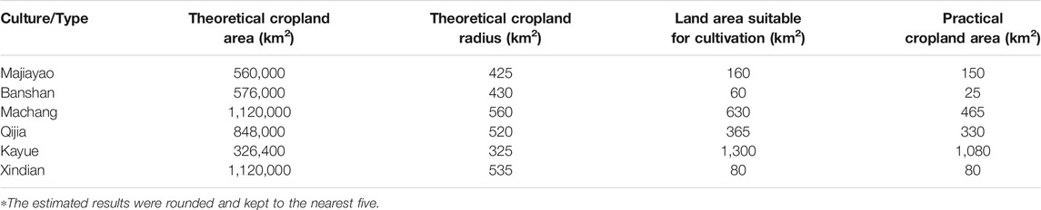
TABLE 4. Cultivated land area in the northeast margin of Qinghai Tibetan Plateau.
Figure 2 illustrates the temporal and spatial distribution of cultivated land throughout the prehistoric time period. Rivers played a central role in the distribution patterns of the cultivated land area. During the early Majiayao culture, the cultivated lands were sparsely distributed along the two major rivers: the Huangshui and the Yellow Rivers. During the late Neolithic Age, the cultivated land area expanded along the Huangshui River and the east edge of QTP appeared to be heavily cultivated. In the mid-late Bronze Age, the cultivated land area expanded westward, to the source region of the Yellow River and its tributaries, and northward to the areas along the Beichuan River, a main tributary of the Huangshui River.
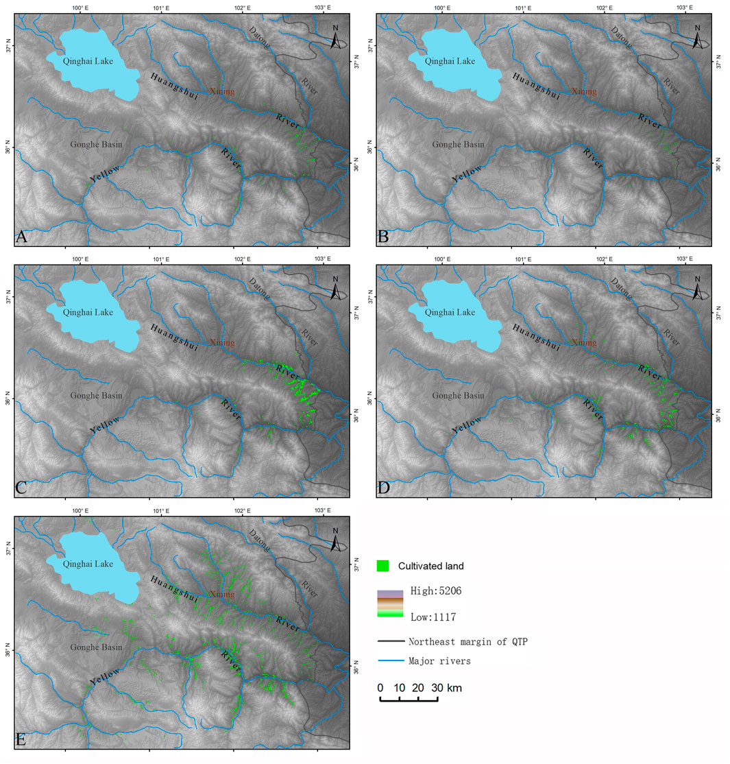
FIGURE 2. Temporal and spatial distribution of cultivated land during each culture/type. (A) Distribution of cultivated land during the Majiayao type. (B) Distribution of cultivated land during the Banshan type. (C) Distribution of cultivated land during the Machang type. (D) Distribution of cultivated land during the Qijia Culture. (E) Distribution of cultivated land during the Xindian and Kayue Cultures.
Palynology
Dating
The high precision AMS14C is reported as a mean age within a range of error. The results indicated that the 3.5 m section of Dianziping site captured a specific, concentrated time period between 4.0 and 3.7 cal ka BP (Table 5); classified as the Qijia cultural period. There was a small inversion of dates, suggesting anthropogenic disturbance to the stratum. The discovery of potsherds and ash pits in the stratum further testified the incidence of anthropogenic activity. Moreover, the potsherds were mainly reddish clay pottery and sand mixed pottery, finely polished. Some of the potsherds were painted with string-like greyish-black lines. These features strengthen the link to Qijia pottery and culture.
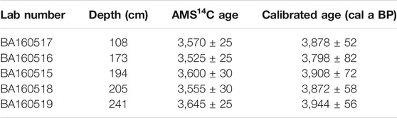
TABLE 5. Charcoal testing result from Dianziping stratum.
Pollen Records
Forty-nine pollen taxa were identified in the Dianziping section, including Pinus, Picea, Betula, Ulmus, Carpinus, Alnus, Hippophae, Nitraria, Ephedra, Artemisia, Taraxacum, Poaceae, Chenopodiaceae, Asteraceae, and Polypodiaceae. The pollen assemblage was largely dominated by arboreal pollen with Pinus accounting for ±62.6% of the total. Herbaceous plants accounted for ±26.6%, Artemisia (±9.9%) and Chenopodiaceae (±10.7%) were the most ubiquitous taxa. Three zones were recognized based on stratigraphically constrained cluster analysis (CONISS) (Figure 3). The three zones were as follows:
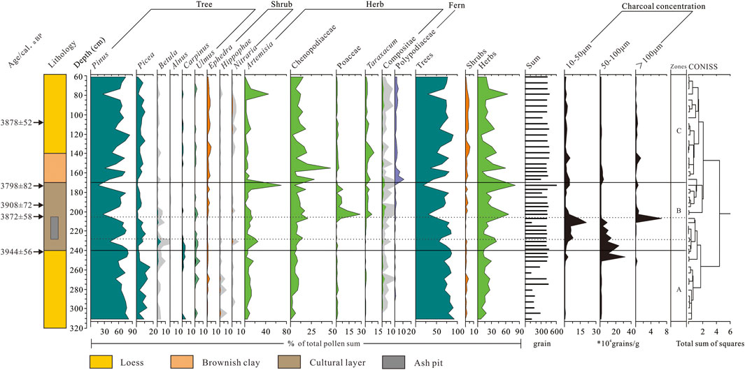
FIGURE 3. Pollen assemblage diagram of Dianziping profile.
Zone A (240–350 cm) In this section, tree pollen, predominantly Pinus (±71.18%), Picea (±8.34%), and some Betula (±0.63%), accounted for ±80% of the total pollen assemblage. Herbaceous plants, consisted mostly of Chenopodiaceae (±5.64%) and artemisia (±8.66%), accounted for ±17.28% of the total.
Zone B (170–240 cm) This section included substantial cultural elements and was similarly characterized by trees as dominant. Pinus and Picea were prevalent, but their relative abundance had evidently decreased to ±58.24 and ±4.69% respectively. Herbs including Artemisia (±13.33%), Chenopodiaceae (±11.71%), and Poaceae (±4.26%) increased compared to Zone A. In total, trees accounted for ±64.4% and herbs accounted for ±33.41%.
Zone C (60–170 cm) In this section, the tree pollen was mainly Pinus (±60.72%) and Picea (±5.68%). The concentration of Ephedra increased substantially compared to the previous stage. Herbaceous plants mainly consisted of artemisia and Chenopodiaceae, particularly Chenopodiaceae increased appreciably to ±14.07% of the total.
In summary, there was a clear indication of anthropogenic activity in Zone B as judged by increases of Poaceae, Artemisia, Chenopodiaceae, Asteraceae, Taraxacum, and a notable decrease in tree pollen.
Charcoal Analysis
Charcoal particles provided reliable evidence for fire. Small charcoal particles could be transported across long distances by wind, especially in dry areas (Huang et al., 2006). These small particles provided evidence for regional fires. Alternatively, large charcoal particles tended to travel only short distances, and serve as a good indicator for local fires (Patterson et al., 1987; Clark, 1988; Miao et al., 2017). Charcoal particles exceeding 100 μm are considered too massive to be suspended and transported over long distances by wind (Clark, 1988). Dianziping site charcoal analyses reveal a concentration of charcoal particles <50, 50–100, and >100 μm at 200–225, 200–250, and 200–210 cm respectively. These findings indicate the occurrence of regional fire events at a period represented at 200–250 cm, and local fire events at 200–210 cm, suggesting increased anthropogenic activity around 3.8–3.9 cal ka BP. The regional fire events appear to have occurred within the cultural layer, while evidence is absent from other layers. It is, thus reasonable to equate the high concentration of charcoal particles during this period as an indication of human activity. In addition, a sharp increase of Poaceae pollen was also observed in this section, which may further suggest that human intervention to the natural vegetation had occurred.
Discussion
Anthropogenic Impact on the Land Cover During the Late Neolithic Age (5.3–4.0 cal Ka BP)
In the early Majiayao culture, the population density was low, and a relatively small area of land was cultivated. These areas were sparsely distributed along the Yellow and Huangshui Rivers. At this point, the anthropogenic impacts on natural vegetation was small. However, in the late Majiayao culture, the population increased dramatically, and agriculture became the primary means of sustenance (Xie, 2002). Notably, the population had increased three to four-folds and reached 39,200 during the Machang period. Concomitantly, the area of cultivated land increased exponentially and reached a peak of 465 km2. Although the cultivated land had decreased during the Banshan Type, the cultivation intensity, attained by dividing the cropland area with the duration of that culture and area of that particular culture (Zhuo et al., 2013), had steadily increased since the beginning of the Majiayao Culture. This trend indicates that, despite the decreasing population, the settlement areas were still densely populated, and surrounding areas were intensely cultivated, even during the Banshan period. Disturbance to the neighboring area continued by expanded areas of cultivation (Figure 4).
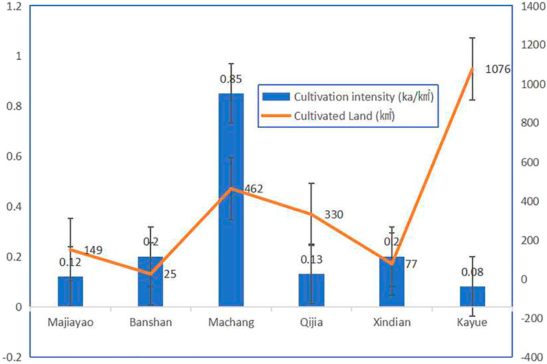
FIGURE 4. Comparison of cultivation intensity and cultivated land area during each culture/type. Blue bar: Cultivation intensity during each culture/type (ka/km2). Orange line: cultivated land (km2).
During the mid-Holocene climatic optimum, coniferous and broadleaf forests grew abundantly in northeast QTP (Zhou et al., 2011). However, shifts in arboreal pollen were recorded around the Changning region (Dong et al., 2012). Around 5.1 cal ka BP, tree pollen such as Picea, Ulmus, and Betula accounted for ±33% of the total, while plant taxa associated with human activity such as Poaceae, Asteraceae, Brassicaceae, Apiaceae, Fabaceae, and Rosaceae (Li Y. Y. et al., 2008) only accounted for ±13%. Around 5.0 cal ka BP, tree pollen decreased and at around 4.2 cal ka BP, reached a low point with approximately ±10% in relative abundance. In contrast, synanthropic species significantly increased during that period, and reached a peak of ±43% of the total pollen assemblage, and in which, Poaceae accounted for ±41% (Figure 5). The decrease in tree pollen was associated with an increase in human-indicator species, especially in Poaceae during the optimum climate condition of mid-Holocene. This was also highly correlated with the population growth and expansion of cropland, as well as the high intensity of cultivation, suggesting human-induced deforestation and land cover change (Figure 4). Anthropogenic disturbance to the original vegetation was evident. The farmers of the Neolithic Age actively deforested neighboring areas to create cropland and to meet the needs of an increasing population. In short, anthropogenic impacts on the environment were initially apparent at approximately 4.3–4.0 cal ka BP on this part of the plateau.
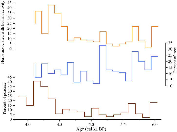
FIGURE 5. Analysis of Changning pollen assemblage.
In addition, the firing of pottery and utilization of wood resources also likely accelerated deforestation. Pottery-making technology during the Majiayao culture was highly developed, and this culture was renowned for its exquisite pottery. According to previous research, a temperature of 800°C is required for the firing of pottery (Papachristodoulou et al., 2006). Wood might have been the most attainable source for fuel at that time and a substantial number of trees utilized for pottery making. Additionally, among the excavated tombs of the Majiayao culture, wooden coffins (coffin made of wood) accounted for 84% of the burials (Qinghai Province Cultural Relics Management Branch Archaeological team, Chinese Academy of Social Sciences, Institute of Archaeology, 1984). To sum up, it appears that tree resources were abundant during the early Majiayao culture. Cropland areas may have been previously forested, but, trees were definitely logged for various of wood usage. It is thus reasonable to conclude that large areas of forests were brought down during this period.
Anthropogenic Impacts on the Natural Vegetation During the Early Bronze Age (4.0–3.6 ka BP)
Qijia culture represents an early period of the Bronze Age. During this period, the overall climate of the QTP gradually shifted from the mid-Holocene’s warm and wet to drier and colder climate (Liu, 2016; Wei H. et al., 2020). This transition continued through the entire Qijia period on the QTP and was synchronous with increasing climatic instability and extreme weather events (Wang et al., 2021). According to Liu (2016), the Genggahai region received relatively low amounts of precipitation between 4.1 and 3.1 cal ka BP. The excavation of the Lajia site confirmed that the area was experiencing frequent mountain torrents, indicating an increase in severe rainstorms (Chui et al., 2019; Wang et al., 2021). Driven by the overall cooling, drying climate, and the increase of extreme weather events, the human population in the area declined slightly, and the production mode of the agricultural settlers also shifted during this period. Farmers appeared to have adopted grazing as an alternative means of sustenance (Xie, 2002; Chen T. et al., 2019). Evidence suggests that people were, at least partially, engaged in pastoralism. Burial objects unearthed during the Qijia culture shifted from pigs to sheep, implying the onset of pastoralism on the northeast margin of QTP (Liu, 2014). Consequently, the cultivation intensity demonstrated a dramatic fell during the Qijia culture (Figure 4). The area of cultivated land decreased compared to that of the Machang Type.
The Dianziping pollen analysis indicates that during the Qijia culture, pine and spruce forests, as well as deciduous broadleaf trees (birch and maple), had persisted in the area. Tree pollen accounted for ±70% and shrubs accounted for ±26.8% of the total pollen assemblage (Figure 3). Trees, especially coniferous taxa, appeared to have been abundant in the area while broadleaf trees were scarce. Therefore, climate change had caused vegetation succession in the high-altitude areas. However, forests in the lower elevation (∼1,870 m) areas in the Hehuang Valley persisted indicating that these areas were still warm and wet enough for the growth of these tree species. Since cultivated land area was also concentrated in the eastern edge of Huangshui Valley. It seems that this part of the QTP was intensely cultivated despite its low human population numbers, which could be drawn from the relatively high intensity of cultivation (Figure 4). Meanwhile, analysis of the charcoal in Dianziping indicated that the incidence of regional fire was frequent between 3.9 and 3.8 cal ka BP (Figure 3). These fires were unlikely to be started naturally as lightning events are typically followed by thunderstorms and heavy precipitation on the QTP. As such, these findings further demonstrated anthropogenic disturbance during this period.
Based on series of archaeological excavations, there are approximately 366 graves of the Qijia culture, among which 288 (approximately 80%) graves used wooden coffins. Over half of these were made from a single cut of wood with diameters of approximately 50 cm. Although both the population and cultivated land area in the northeast margin of the QTP decreased during the Qijia culture, forest destruction in the region continued. Despite climate change being a major driving force for the reduction of deciduous broadleaf forests, human destruction to the forests, especially to the disappearance of coniferous forests on the river terraces in the valleys, are undeniable. In conclusion, it appears that during the Qijia culture, large scale ecological shifts were mainly driven by climatic changes. The changes obviously caused forest decline in high altitude areas and ecological succession in lower areas (Kramer et al., 2009a; Kramer et al., 2009b). On the other hand, intensive cultivation and lumber utilization in settlement areas accelerated the pace of deforestation at lower elevations.
Anthropogenic Impact on Natural Vegetation During Mid-Late Bronze Age (3.6–2.4 cal ka BP)
During the mid-late Bronze Age, the northeast QTP was occupied by people of the Xindian and Kayue cultures. The relatively cold and dry climate, dictated the people to undertake some changes concerning their means of sustenance (Jia, 2012; Dong et al., 2013; Chen et al., 2015; Ren et al., 2018). One such change to the farming practice was a shift from the monoculture of millet to developed multiple crops. Barley, as cold-resistant crop, became staple in the harsh highlands (Ma et al., 2016; Zhang and Dong, 2017). Sheep, as cold-tolerant livestock, were introduced into this region in the early Bronze Age via cross-mainland cultural exchange, and grazing livestock was broadly adopted (Dodson et al., 2013; Dong, 2018). In addition, the number of pigs associated with funeral sties began to decrease and were replaced by sheep, horses, and cattle (Liu, 2014), which implies the growing importance of grazing in the Kayue culture. The development of pastoralism allowed farming activities to expand from low altitude to high altitude areas despite the dry and cold climate, and to settle permanently in areas with elevations above three thousand meters (Chen et al., 2015). Consequently, Kayue culture developed quickly in the higher altitude areas, practicing both grazing and farming. The Xindian culture was mainly distributed at lower altitude areas in the east of the study area, and was sustained by traditional farming. The shifts in production structure boosted the population growth and the development of agriculture. The total population in the northeast margin of QTP reached approximately 61,330 people, and the cropland area amounted to over 1,160 km2 (Table 4). These croplands were mainly distributed along the Yellow River, and its major tributaries, expanding into the upper reaches of the Yellow River. As figure four illustrates, the adoption of grazing reduced cultivation intensity but the exponential population growth enlarged the overall impacted area. The population growth and the subsequent cropland expansion significantly resulted in human-induced environmental destruction in the natural areas, especially at high altitudes. Furthermore, increasing charcoal concentration in Gonghe Basin during the Kayue culture was accompanied by increasing human imprints and disturbances to the high-altitude areas (Miao et al., 2017).
Wood was used as raw material for construction, production tools, and fuel for the fire (Wang et al., 2014). Generally, charcoal remains from the burning of dead wood were rich in mycelium (Marguerie and Hunot, 2009; Vidal-Matutano et al., 2017). In the charcoal analysis from the Kayue and the Xindian cultural sites, mycelium was rarely encountered (Liu, 2019). Based on the absence of mycelium, it can be inferred that the increasing population during the mid-late Bronze Age could have resulted in massive logging for fuel. In the Liuwan site, six graves of the Xindian culture were excavated, but none used wooden coffins (Qinghai Province Cultural Relics Management Branch Archaeological team, Chinese Academy of Social Sciences, Institute of Archaeology, 1984). The excavation of Hetao Zhuang grave, located along a tributary of Huangshui River in Milagou, revealed 342 graves, 102 of which used wood coffins (Qinghai Province Cultural Relics Archaeological Institute, 2004). In Guide Shan Pingtai site, along the Yellow River, 90 graves of the Kayue Culture were excavated, of which, 32 graves contained wooden coffins made of woods with diameter of only 10 cm. This suggests that forests along the Huangshui River were mostly exhausted. Trees were quite limited even along the upper reaches of Yellow River where only small trees and shrubs remained. Moreover, Liu (2019) states that Pinus was easily shaped, yet hard to corrode, making it a favorable choice for use by prehistoric humans. However, the number of broadleaf trees used by prehistoric Kayue people was significantly higher than that of coniferous species. Approximately two-thirds of the wood came from broadleaf trees. This demonstrates that the availability of conifers such as Pinus has been greatly reduced, but the climate still allowed the growth of deciduous broadleaf trees. In addition, the pollen assemblage from Fengtai site in Huzhu County disclosed a variety of Poaceae taxa that no longer existed in the area. This is a testament to the rich floral biodiversity in the region during the Kayue culture and that climate allowed their abundance (Jin et al., 2006). In sum, despite having a climate that was optimal for supporting the diversity of flora and growth of deciduous broadleaf trees during that time, the forest resources were being depleted. This is supported by both archaeological evidence of wood utilization and by the pollen assemblage from Dalianhai, which showed a decreasing trend of Pinus and Picea and steady increase of Poaceae (Cheng et al., 2013) (Figure 6).
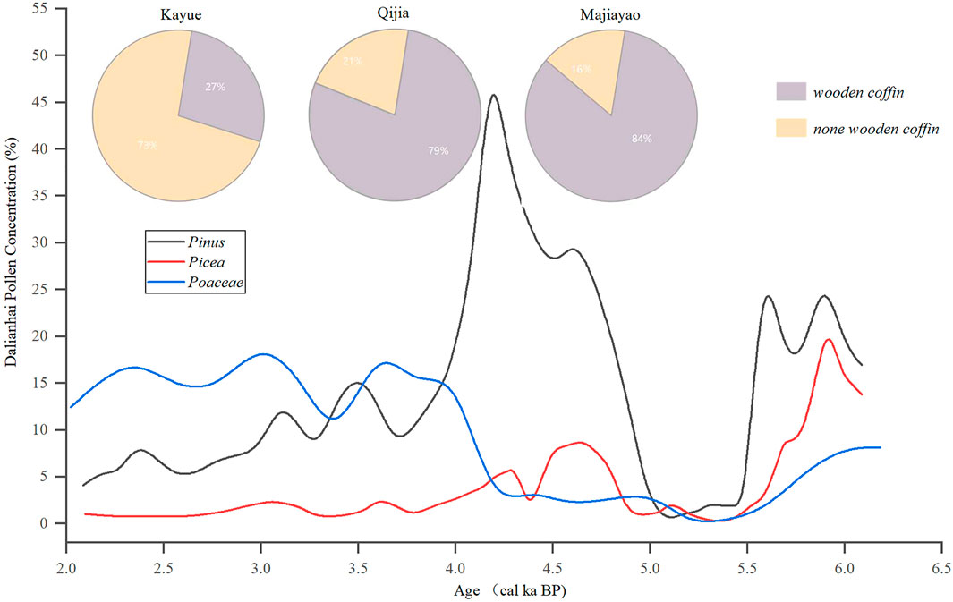
FIGURE 6. Analysis of Dalianhai pollen assemblage and utilization of wood for construction of coffin.
Ecological studies conducted on the grasslands of the QTP show that grazing by domesticated livestock caused an increase of Stellera chamaejasme across the landscape (Huang et al., 2017; Wei H. et al., 2020; Wei H.-C. et al., 2020). This species is toxic and was not consumed by livestock. Grazing of other species accelerates the growth of Stellera, enabling it to eventually become the dominant species on the grassland (Liu et al., 2004). The increasing abundance of Stellera chamaejasme, therefore, is an indicator of overgrazing and grassland degradation (Miehe et al., 2014). The pollen assemblage from Genggahai illustrates a rapid proliferation of Stellera chamaejasme around 3.6–3.0 cal ka BP in the surrounding areas. This indicates intensive grazing activity resulting in the degradation of previously Artemisia dominated steppe (Huang et al., 2017). This is consistent with the results of a sediment core analysis in Lake Muge, where the occurrence of frequent anthropogenic fire events showed expansion of cropland and pasture. The resulting environmental impacts of these activities induced great alterations of the natural vegetation (Sun et al., 2016).
In all, during this period, both the human populations and the cultivated land areas had increased significantly due to a progression in environmental adaptability. The Kayue people had moved up to the middle and high-altitude areas and practiced grazing as a primary means of livelihood, and crop cultivation as alternative sustenance. As a result, the pristine forests in these areas were largely destroyed, and the grassland cover was disturbed by both cultivation and grazing activities. It appears that anthropogenic impacts had been the major driving force for land deterioration and forest decline during this period.
Environmental Impacts During the Historical Time
The analysis of Genggahai and Dalianhai pollen assemblages show that since 1.6 cal ka BP, herbaceous pollen had increased, while tree pollen decreased (Cheng et al., 2013; Liu, 2016). In Genggahai region, the growth of herbaceous pollen, such as Stellera, Artemisia, and Chenopodiaceae was evident, and degradation of the grassland was apparent. The soil in the region was arid and low in organic matter, and the region was successively transformed into a desert steppe (Liu, 2016). In the Dalianhai area, at 1.4 cal ka BP, the humidity gradually increased, and the grassland began to expand. However, forested areas were not restored due to the slow succession rate of forest re-generation itself and the extensive deforestation that previously occurred in the area (Cheng et al., 2013). Soil water retention capacity was reduced, signs of soil erosion in the surrounding area were apparent, and grassland degradation was evident with the increasing growth of Stellera. It appears that anthropogenic activity, including over-grazing, was a driving force for land degradation.
The three main expansion periods of cultivation during the historical period in China occurred during the Han Dynasty, the Song Dynasty and mid-Qing Dynasty (Fang et al., 2019). In approximately 2.2 cal ka BP, the Han Dynasty colonized the areas along the Huangshui River and implemented “military cultivation” and “immigration garrison” policies to supply food to the military in the area (Gong, 2012). To ensure the implementation of these policies, over ten thousand soldiers were staged in the region to cultivate the barren land in Ledu (along the Huangshui River). Advanced iron plow techniques were introduced, and agriculture became highly developed (Gu, 2007). Postal stations and bridges were also constructed in the area during this period. According to the Legend of Zhao Chongguo and Xin Qingji, during the construction, over six thousand trees were logged from the adjacent mountains and transported along the Huangshui River. This depleted the forests in the Huangshui Valley, leaving trees mainly on the adjacent mountains. In the Tang Dynasty “military cultivation” and expansion of cropland in the Hehuang Valley reached approximately 321 km2 (Wu et al., 2017). During the Song Dynasty, according to Qing Tang Record, only a few clusters of pine trees were observed along the Huangshui River. The total cropland area in Hehuang Valley was approximately 305 km2, congruent with Tang Dynasty (Guo et al., 2021). By the Ming Dynasty, the population had increased rapidly in the area (Cui et al., 1999; Zhang et al., 2016). In the late Ming Dynasty, 1650AD, the cropland area in the Hehuang Valley reached approximately 433 km2 (Zhao, 2016). The structure of forest vegetation in the valley had changed significantly, with poplar and birch replacing the original pine and spruce forests (Qinghai Local Chronicle Compilation Committee, 1993). By the Qing Dynasty, dry farming had been widely developed and the cultivated land gradually expanded into the hills and mountains (Wang et al., 2000). In 1747AD, Yang Yingju recorded in Annals of Xining Fu, that most of the mountains along the middle reaches of the Huangshui River were barren lands (Yang and Wang, 1747). Timber for construction of Xining Fu had to be transported from distant mountains. By the late Qing Dynasty, in 1845AD, the cropland in Hehuang Valley reached approximately 1,505 km2.
In conclusion, croplands were abandoned and re-cultivated frequently and expanded continually; forests and shrubs were heavily harvested. Cropland expansion increasingly pushed the carrying capacity of the land toward the edge of limitation. Large areas of barren hillsides were formed in Hehuang area. Soil erosion and landslides occurred more frequently following the deterioration of the natural vegetation. There were no major climate fluctuations during the historical period suggesting the destruction of vegetation cover was overtly induced by anthropogenic factors. Currently, natural forest in the area is patchy and scattered across the hills and slopes found at elevations ranging from 2,600 to 3,400 m (Zhou et al., 1986). This further demonstrates that the destruction of forests and the deterioration of grassland during the historical period were primarily due to anthropogenic forces.
Conclusion
(1) This paper addresses human impacts on the natural vegetation in the northeast margin of the QTP. The study explains the extent of anthropogenic influence on the natural land cover through cropland expansion, with the support of pollen records and archaeological data. Cultivated land areas were reconstructed using population estimates and prehistorical site reconstruction. Altitude, soil, distance to the river, slope aspect, and gradient are considered to be natural limiting factors for the expansion of cropland. The Dianziping pollen assemblage was analyzed and compared to previous pollen studies in the area.
(2) In the mid-Holocene climatic optimum, the reduction of tree pollen can be explained by the intrusion of Neolithic farmers and expansion of cropland, as well as heavy utilization of timber resources. The decline of forests and shift in vegetation composition, including a reduction of flora diversity during the early Bronze Age may be explained by adverse climatic impacts, but human exploitation of forests and destruction of land cover at low elevated rivers terraces were also evident. During the mid-late Bronze Age, climatic impacts appeared to be less influential, while the expansion of cropland and population growth likely resulted in the continued diminishing of forests. Humans likely drove the ecological succession of natural vegetation to the current pastureland. The current landscape, characterized by barren mountains and remnant forest islands can be explained by the large-scale deforestation that occurred throughout human history.
(3) A strong correlation was found to exist among the occurrence of population growth, cropland expansion, and reduction of tree pollen found at prehistoric sites. Population growth instigated a self-reinforcing cycle whereby more cropland was required to support inhabitants and more inhabitants cultivated more land, which in turn, boosted population growth. Consequently, extensive logging and burning of natural forest cover were performed for various human purposes and resulted in significant reductions in tree pollen.
(4) Neolithic farmers planted corps mainly on terraces in river valleys along the Huangshui River. In the late Bronze Age, the cultivated land area quickly expanded to the small hills and flat terrain at higher altitudes along the upper reaches of the Yellow River. The development of cropland along the Yellow River in the northeast margin of QTP occurred slightly later than that of the Huangshui River.
Data Availability Statement
The raw data supporting the conclusions of this article will be made available by the authors, without undue reservation.
Author Contributions
ZW and GH designed the study and wrote the paper, GH reconstructed the cultivated land, ZW and JG conducted the pollen analysis, SJ, XC, ZL conducted the field work.
Funding
This study was supported by Natural Science Fund of Qinghai Province, Grant No. 2021-ZJ-917.
Conflict of Interest
The authors declare that the research was conducted in the absence of any commercial or financial relationships that could be construed as a potential conflict of interest.
References
Bellwood, P., Gamble, C., Steven, A. L. B., Pluciennik, M., Richards, M., and Terrell, J. E. (2005). First Farmers: The Origins of Agricultural Societies. London, United Kingdom: Blackwell Publishing.
Bronk Ramsey, C. (2015). OxCal Program v4.2.4. Oxford, United Kingdom: Oxford Radiocarbon Accelerator Unit, Research Lab for Archaeology, University of Oxford. Available at: https://c14.arch.ox.ac.uk/oxcal/OxCal.html (Accessed March 15).
Bureau of National Cultural Relics (1996). Atlas of Chinese Cultural Relics- Fascicule of Qinghai Province. Beijing, China: China Cartographic Publishing Press.
Cavalli-Sforza, L., Menozzi, P., and Piazza, A. (1993). Demic Expansions and Human Evolution. Science 259, 639–646. doi:10.1126/science.8430313
Chen, F. H., Dong, G. H., Zhang, D. J., Liu, X. Y., Jia, X., An, C. B., et al. (2015). Agriculture Facilitated Permanent Human Occupation of the Tibetan Plateau after 3600 B.P. Science 347 (6219), 248–250. doi:10.1126/science.1259172
Chen, Q., Liu, F., Fang, X., Zhou, Q., Chen, Q., and Chen, R. (2019). Reconstruction of Cropland Distribution in the Late Neolithic Period in Northern China. Geo. Res. 38 (12), 2927–2940. doi:10.11821/dlyj020181293
Chen, T., Jia, X., Li, H., and Dong, G. (2019). The Analysis of Spatio Temporal Transformations of Agricultural and its Influence Factors During Qijia Culture Period in Gansu Qinghai Region. Quat. Sci. 39 (1), 132–144. doi:10.11928/j.issn.10017410.2019.01
Cheng, B., Chen, F., and Zhang, J. (2013). Palaeovegetational and Palaeoenvironmental Changes since the Last Deglacial in Gonghe Basin, Northeast Tibetan Plateau. J. Geogr. Sci. 23 (1), 136–146. doi:10.1007/s11442-013-0999-5
Chui, Y. D., Huang, C. C., Pang, J. L., Zhou, Y. L., Zhang, Y. Z., Guo, Y. Q., et al. (2019). Study of the Soil Sequence and the Dating of Prehistoric Mountain Torrent Disaster in La Jia Ruins, Qinghai Province. Acta Geogra. Sinica 74 (11), 2371–2384. doi:10.11821/dlxb201911013
Clark, J. S. (1988). Particle Motion and the Theory of Charcoal Analysis: Source Area, Transport, Deposition, and Sampling. Quat. Res. 30, 67–80. doi:10.1016/0033-5894(88)90088-9
Cui, Y. H., Zhang, D. Z., and Du, C. S. (1999). General History of Qinghai. Xining, China: Qinghai People’s Publishing House.
Dodson, J. R., Li, X., Zhou, X., Zhao, K., Sun, N., and Atahan, P. (2013). Origin and Spread of Wheat in China. Quat. Sci. Rev. 72, 108–111. doi:10.1016/j.quascirev.2013.04.021
Dong, G. (2018). Understanding Past Human-Environment Interaction from an Interdisciplinary Perspective. Sci. Bull. 63 (16), 1023–1024. doi:10.2018-16-00310.1016/j.scib.2018.07.013
Dong, G., Jia, X., An, C., Chen, F., Zhao, Y., Tao, S., et al. (2012). Mid-Holocene Climate Change and its Effect on Prehistoric Cultural Evolution in Eastern Qinghai Province, China. Quat. Res. 77 (1), 23–30. doi:10.1016/j.yqres.2011.10.004
Dong, G., Jia, X., Elston, R., Chen, F., Li, S., Wang, L., et al. (2013). Spatial and Temporal Variety of Prehistoric Human Settlement and its Influencing Factors in the Upper Yellow River Valley, Qinghai Province, China. J. Archaeol. Sci. 40 (5), 2538–2546. doi:10.1016/j.jas.2012.10.002
Edwards, K. J., and MacDonald, G. M. (1991). Holocene Palynology: II Human Influence and Vegetation Change. Prog. Phys. Geogr. Earth Environ. 15, 364–391. doi:10.1177/030913339101500402
Ellis, E. C., Kaplan, J. O., Fuller, D. Q., Vavrus, S., Klein Goldewijk, K., and Verburg, P. H. (2013). Used Planet: A Global History. Proc. Natl. Acad. Sci. U.S.A. 110 (20), 7978–7985. doi:10.1073/pnas.1217241110
Fang, H. (2007). Archaeological Theory and Practice in Settlement and Environment. Shandong, China: Shandong University Publishing House.
Fang, X. Q., Ye, Y., Zhang, C. P., and Tang, C. C. (2019). Cropland Cover Change and its Environmental Impacts in the History of China. J. Paleogeogr. 21 (1), 160–174. doi:10.4135/9781446247501.n891
Gaillard, M.-J., Morrison, K. D., Madella, M., and Whitehouse, N. (2018). Past Land-Use and Land-Cover Change: The Challenge of Quantification at the Subcontinental to Global Scales. PAGES Mag. 26 (1), 1–44. doi:10.22498/pages.26.1.3
Goldewijk, K. K., Drecht, G. V., and Bouwman, A. F. (2007). Mapping Contemporary Global Cropland and Grassland Distributions on a 5 × 5 minute Resolution. J. Land Use Sci. 2 (3), 167–190. doi:10.1080/17474230701622940
Guo, R., Liu, F.-g., Chen, Q., Zhou, Q., Gu, X.-j., and Cai, X.-c.-m. (2021). Reconstruction of Cultivated Land Pattern in the Upper Reaches of the Yellow River in the Late Northern Song Dynasty:Take Hehuang Valley as an Example. J. Nat. Resour. 36 (1), 27–37. doi:10.31497/zrzyxb.20210102
Han, X. Y., Ying, H. S., and Wang, J. (2020). The Influencing Factors of Cultivated Land Utilization in Lv Liang Mountain Area. J. Shanxi Agri. Sci. 48 (10), 1679–1682+1692. doi:10.15405/epsbs.2020.10.02.33
Harlan, J. R. (1971). Agricultural Origins: Centers and Noncenters. Science 174, 468–474. doi:10.1126/science.174.4008.468
Hou, G., Lai, Z., Xiao, J., and Chongyi, E. (2012). Reconstruction of Cultivated Land during Mid- Holocene in the Middle and Lower Reaches of Yellow River and Human Impact on Vegetations. J. Geogr. Sci. 22 (5), 933–945. doi:10.1007/s11442-012-0974-6
Huang, C. C., Pang, J., Chen, S., Su, H., Han, J., Cao, Y., et al. (2006). Charcoal Records of Fire History in the Holocene Loess–Soil Sequences Over the Southern Loess Plateau of China. Palaeogeogr. Palaeoclimatol. Palaeoecol. 239 (1–2), 28–44. doi:10.1016/j.palaeo.2006.01.004
Huang, M., Ji, J. J., and Peng, L. L. (2008). The Response of Vegetation Net Primary Productivity to Climate Change During 1981- 2000 in the Tibetan Plateau. Clim. Environ. Res. 13 (5), 608–616. doi:10.1016/j.scitotenv.2012.12.014
Huang, X.-z., Liu, S.-s., Dong, G.-h., Qiang, M.-r., Bai, Z.-j., Zhao, Y., et al. (2017). Early Human Impacts on Vegetation on the Northeastern Qinghai–Tibetan Plateau during the Middle to Late Holocene. Prog. Phys. Geogr. Earth Environ. 41 (3), 286–301. doi:10.1177/0309133317703035
Jia, X. (2012). Study of the Cultural Evolution and Plant Remains of Neolithic-Bronze Age in Northeast Qinghai Province. Dissertation. Lanzhou (China): Lanzhou University.
Jia, X., Dong, G., Li, H., Brunson, K., Chen, F., Ma, M., et al. (2013). The Development of Agriculture and its Impact on Cultural Expansion during the Late Neolithic in the Western Loess Plateau, China. The Holocene 23 (1), 85–92. doi:10.1177/0959683612450203
Jia, X., Lee, F. L., Cui, M., Cheng, G., Zhao, Y., Ding, H., et al. (2019). Differentiations of Geographic Distribution and Subsistence Strategies Between Tibetan and Other Major Ethnic Groups are Determined by the Physical Environment in Hehuang Valley. Sci. China Earth Sci. 62 (2), 412–422. doi:10.1007/s11430-018-9301-5
Jin, G. Y., Wang, W., Wagner, M., and Tarasov, P. E. (2006). Palynology Analysis and Human Activities at the Kayue Cultural Site in Fengtai, Huzhu, Qinghai Province—Results of Fossil and Modern Topsoil Pollen Analysis. Huaxia Archaeol. 14 (3), 24–32. doi:10.16143/j.cnki.1001-9928.2006.03.004
Kramer, A., Herzschuh, U., Mischke, S., and Zhang, C. (2009a). Holocene Treeline Shifts and Monsoon Variability in the Hengduan Mountains (Southeastern Tibetan Plateau), Implications from Palynological Investigations. Palaeogeogr. Palaeoclimatol. Palaeoecol. 286 (2010), 23–41. doi:10.1016/j.palaeo.2009.12.001
Kramer, A., Herzschuh, U., Mischke, S., and Zhang, C. (2009b). Late Glacial Vegetation and Climate Oscillations on the Southeastern Tibetan Plateau Inferred from the Lake Naleng Pollen Profile. Quat. Res. 73 (2), 324–335. doi:10.1016/j.yqres.2009.12.003
Li, D.-M., Guo, Z.-G., and An, L.-Z. (2008). Assessment on Vegetation Restoration Capacity of Several Grassland Ecosystems under Destroyed Disturbance in Permafrost Regions of Qinghai-Tibet Plateau. Ying Yong Sheng Tai Xue Bao 19 (10), 2182–2188. doi:10.5194/tc-2015-218-rc2
Li, Y. Y., Zhou, L. P., and Cui, H. T. (2008). Indicative Pollen for Human Activity. Sci. Briefings 7 (9), 991–1002. doi:10.1007/s11434-008-0181-0
Li, G. R., Chen, Y. Y., Niu, Q. F., Song, Y. R., and Wei, D. D. (2014). Particle Size Characteristics and Paleo-Environmental Significance of Dalianhai Sediments. J. Qinghai Univ. 32 (4), 65–83. doi:10.13901/j.cnki.qhwxxbzk.2014.04.012
Li, G. Y., Qian, Z. S., and Hu, J. (1995). Palynological Analysis Manual. Beijing, China: Geological Publishing House.
Li, X., Sun, N., Dodson, J., and Zhou, X. (2012). Human Activity and its Impact on the Landscape at the Xishanping Site in the Western Loess Plateau during 4800–4300 cal yr BP Based on the Fossil Charcoal Record. J. Archaeol. Sci. 39 (2012), 3141–3147. doi:10.1016/j.jas.2012.04.052
Liu, F. W. (2019). Human Wood Utilization Strategy in the Northeast of Qinghai Tibetan Plateau During Neolithic and Bronze Age. Dissertation. Lanzhou (China): Lanzhou University.
Liu, S. S. (2016). Vegetation and Climate Change since the Last Deglaciation in the Northeast Qinghai–Tibetan Plateau Genggahai Region. Dissertation. Lanzhou (China): Lanzhou University.
Liu, Y., Long, R. J., and Yao, T. (2004). Research Progress on Stellera chamajasme L. on Grassland. Pratacultural Sci. 21 (6), 55–61. doi:10.3969/j.issn.1001-0629.2004.06.017
Liu, Z. H. (2014). Discussion of Climate Change and Cultural Evolution in Hehuang Area—Case of Majiayao, Qijia, Xindian and Kayue Cultures Were Investigated. Theo. Res. 20, 141–143. doi:10.1163/9789004322714_cclc_2015-0133-009
Lowe, J. J., and Walker, M. J. C. (1997). Reconstructing Quaternary Environments. 2nd ed. London, United Kingdom: Addison-Wesley.
Luo, J., Chen, Q., Liu, F. G., Zhang, Y. L., and Zhou, Q. (2015). Methods for Reconstructing Historical Cropland Spatial Distribution of the Yellow River-Huangshui River Valley in Tibetan Plateau. Geo. Sci. Prog. 21 (2), 207–216. doi:10.11820/dlkxjz.2015.02.00910.11820/dlkxjz.2015.02.009
Ma, M., Dong, G., Jia, X., Wang, H., Cui, Y., and Chen, F. (2016). Dietary Shift after 3600 Cal Yr BP and its Influencing Factors in Northwestern China: Evidence from Stable Isotopes. Quat. Sci. Rev. 145, 57–70. doi:10.1016/j.quascirev.2016.05.041
Marguerie, D., and Hunot, J.-Y. (2009). Charcoal Analysis and Dendrology: Data from Archaeological Sites in North-Western France. J. Archaeol. Sci. 34 (10), 1417–1433. doi:10.1016/j.jas.2006.10.032
Miao, Y. F., Zhang, D. J., Cai, X. M., Li, F., Jin, H. L., Wang, Y. P., et al. (2017). Holocene Fire on the Northeast Tibetan Plateau in Relation to Climate Change and Human Activity. Quat. Int. 443, 124–131. doi:10.1016/j.quaint.05.029
Miehe, G., Hasson, S., Glaser, B., Mischke, S., Böhner, J., van der Knaap, W. O., et al. (2021). Föhn, Fire and Grazing in Southern Tibet? A 20,000-Year Multi-Proxy Record in an Alpine Ecotonal Ecosystem. Quat. Sci. Rev. 256, 106817. doi:10.1016/J.QUASCIREV.2021.106817
Miehe, G., Miehe, S., Böhner, J., Kaiser, K., Hensen, I., Madsen, fnm., et al. (2014). How Old is the Human Footprint in the World's Largest Alpine Ecosystem? A Review of Multiproxy Records from the Tibetan Plateau from the Ecologists' Viewpoint. Quat. Sci. Rev. 86, 190–209. doi:10.1016/j.quascirev.2013.12.004
Papachristodoulou, C., Oikonomou, A., Ioannides, K., and Gravani, K. (2006). A Study of Ancient Pottery by Means of X-Ray Fluorescence Spectroscopy, Multivariate Statistics and Mineralogical Analysis. Anal. Chim. Acta 573–574, 347–353. doi:10.1016/j.aca.2006.02.012
Patterson, W. A., Edwards, K. J., and Maguire, D. J. (1987). Microscopic Charcoal as a Fossil Indicator of Fire. Quat. Sci. Rev. 6 (3), 3–23. doi:10.1016/0277-3791(87)90012-610.1525/9780520337404
Pielke, R. A., Pitman, A., Niyogi, D., Mahmood, R., McAlpine, C., Hossain, F., et al. (2011). Land Use/Land Cover Changes and Climate: Modeling Analysis and Observational Evidence. WIREs Clim. Change 2 (6), 828–850. doi:10.1002/wcc.144
Pongratz, J., Reick, C., Raddatz, T., and Claussen, M. (2008). A Reconstruction of Global Agricultural Areas and Land Cover for the Last Millennium. Glob. Biogeochem. Cycles 22 (3), GB3018. doi:10.1029/2007GB003153
Qiao, Y. (2010). The Evolutionary History of Complex Society in Yiluo Region between Peiligang to Erlitou Cultural Time. Acta Aechaeol. Sinica 45 (4), 423–454. doi:10.1017/cbo9781139034395.006
Qinghai Local Chronicle Compilation Committee (1993). Chronicle of Qinghai Province: Forestry. Xining, China: Qinghai People’s Publishing House.
Qinghai Province Cultural Relics Archaeological Institute (2004). Minhe He Tao Zhuang. Beijing, China: Science Press.
Qinghai Province Cultural Relics Archaeological Institute (1990). Minhe Yangshan. Beijing: Heritage Press.
Qinghai Province Cultural Relics Management Branch Archaeological team, Chinese Academy of Social Sciences, Institute of Archaeology (1984). Qinghai Liuwan. Beijing, China: Heritage Press, 125–146.
Reimer, P. J., Bard, E., Bayliss, A., Beck, J. W., Blackwell, P. G., Ramsey, C. B., et al. (2013). IntCal13 and Marine13 Radiocarbon Age Calibration Curves 0-50,000 Years Cal BP. Radiocarbon 55, 1869–1887. doi:10.1017/S003382220004886410.2458/azu_js_rc.55.16947
Ren, G. (2000). Decline of the Mid- to Late Holocene Forests in China: Climatic Change or Human Impact?, J. Quat. Sci. 15 (3), 273–281. doi:10.1002/(SICI)1099-141710.1002/(sici)1099-1417(200003)15:3<273::aid-jqs504>3.0.co;2-2
Ren, L., Dong, G., Li, H., Rhode, D., Flad, R. K., Li, G., et al. (2018). Dating Human Settlement in the East-Central Tibetan Plateau During the Late Holocene. Radiocarbon 60, 137–150. doi:10.1017/RDC.2017.117
Ren, X. Y. (1998). Random Notes of Gamatai Site Excavation, Compilation of the Committee on Learning and Literature and History of the CPPCC Qinghai Province, Archaeological Records of Qinghai. Xining, China: Qinghai People’s Publishing House, 65–73.
Su, B. Q., Zhang, Z. P., and Yan, W. M. (2010). Ancient China. Shanghai, China: Shanghai People’s Publishing House.
Sun, W., Zhang, E., Shen, J., Chen, R., and Liu, E. (2016). Black Carbon Record of the Wildfire History of Western Sichuan Province in China over the Last 12.8 Ka. Front. Earth Sci. 10 (4), 634–643. doi:10.1007/s11707-015-0546-z
Vasey, D. E. (1992). An Ecological History of Agriculture: 10,000 B. C.—A. D. Ames, IA: Iowa State University Press, 363.
Vidal-Matutano, P., Henry, A., and Théry-Parisot, I. (2017). Dead Wood Gathering Among Neanderthal Groups: Charcoal evidence from Abric del Pastor and El Salt (Eastern Iberia). J. Archaeol. Sci. 80, 109–121. doi:10.1016/j.jas.2017.03.001
Vita Finzi, C. (1969). “Early Man and the Environment,” in Trends in Geography, an Introductory Survey. Editors R. U. Cooke, and J. H. Johnson (Oxford and New York, NY: Pergamon Press).
Vitousek, P. M., Mooney, H. A., Lubchenco, J., and Melillo, J. M. (1997). Human Domination of Earth's Ecosystems. Science 277, 494–499. doi:10.1007/978-0-387-73412-5_110.1126/science.277.5325.494
Wang, A. M., Liu, J. L., and Miao, L. L. (2000). The Historical Transformation of Man-Environment Relationship in the North-Eastern Border of Tibetan Plateau and its Surrounding Areas. Hum. Geogr. 15 (2), 58–63. doi:10.13959/j.issn.1003-2398.2000.02.015
Wang, H., Huang, C. C., Pang, J., ZhouCuan, Y. Y. D., Cuan, Y., Guo, Y., et al. (2021). Catastrophic Flashflood and Mudflow Events in the Pre-historical Lajia Ruins at the Northeast Margin of the Chinese Tibetan Plateau. Quat. Sci. Rev. 251, 106737. doi:10.1016/J.QUASCIREV.2020.106737
Wang, S. Z., Li, H., Zhang, L. R., Cheng, G. K., and WangZhao, P. Z. J. (2014). Tree Exploitation and Palaeo-Environment at Heishuiguo Xichengyi Site, Zhangye City, Gansu Province, Revealed with Excavated Charcoal Analysis. Quat. Sci. 2014, 43–50. doi:10.3969/j.issn.1001-7410.2014.06
Wei, H., Chongyi, E., Zhang, J., Sun, Y., Li, Q., Hou, G., et al. (2020). Climate Change and Anthropogenic Activities in Qinghai Lake Basin Over the Last 8500 Years Derived from Pollen and Charcoal Records in an Aeolian Section. Catena 193, 104616. doi:10.1016/j.catena.2020.104616
Wei, H.-c., Hou, G.-l., Fan, Q.-s., Madsen, D. B., Qin, Z.-j., Du, Y.-s., et al. (2020). Using Coprophilous Fungi to Reconstruct the History of Pastoralism in the Qinghai Lake Basin, Northeastern Qinghai–Tibetan Plateau. Prog. Phys. Geogr. Earth Environ. 44, 70–93. doi:10.1177/0309133319869596
Wu, Z. L., Liu, F. G., Chen, Q., Zhou, Q., and Yang, D. X. (2017). Reconstruction of Cropland Spatial Patterns in 733 AD along the Yellow River. Res. Sci. 39 (2), 252–262. doi:10.4324/9780203480243
Xie, D. J. (2002). Prehistoric Archaeology in Ganqing Region. Beijing, China: Cultural Relics Press.
Yang, G. (1998). Speculation on Yield Per Mu in Xia, Shang and Zhou Dynasties. Agric. Hist. China 13 (2), 24–26.
Yang, Y. J., and Wang, Y. (1747). Xining Fu New Records. Xining, China: Qinghai People’s Publish House.
Zeng, Y. N., Jin, W. P., He, L. L., et al. (2012). Land Use Mapping Using Remote Sensing for Eastern Part of Qinghai Plateau. Trans. Chin. Soc. Agric. Eng. 28 (6), 225–231. doi:10.3969/j.issn.1002-6819.2012.16.035
Zhang, D. J., Dong, G. H., Wang, H., Ren, X. Y., Ha, B. B., Qiang, M. R., et al. (2016). History and Possible Mechanisms of Prehistoric Human Migration to the Tibetan Plateau). Sci. China Earth Sci. 46, 1007–1023. 10.1007/s11430-015-5482-x
Zhang, D. J., Shen, X. K., Cheng, T., Xia, H., Liu, W., Gao, X., et al. (2020a). New Progress in Prehistoric Human Activity in Qinghai-Tibet Plateau. Chin. Sci. Bull. 65 (6), 475–482. doi:10.1360/TB-2019-0382
Zhang, J., Yuan, M. S., Zhang, J., Li, H. W., Wang, J. W., Zhang, X., et al. (2020b). Responses of the NDVI of Alpine Grasslands on the Qinghai–Tibetan Plateau to Climate Change and Human Activities over the Last 30 Years. Acta Ecol. Sin. 40 (18), 6269–6281. doi:10.1007/s10584-006-9135-1
Zhang, S., and Dong, G. (2017). Human Adaptation Strategies to Different Altitude Environment During Mid-Late Bronze Age in Northeast Tibetan Plateau. Quat. Res. 37 (4), 696–708. doi:10.11928/j.issn.1001-7410.2017.04.03
Zhang, X., Wang, W.-C., Fang, X., Ye, Y., and Zheng, J. (2012). Agriculture Development-Induced Surface Albedo Changes and Climatic Implications Across Northeastern China. Chin. Geogr. Sci. 22 (3), 264–277. doi:10.1007/s11769-012-0535-z
Zhao, Y. J. (2016). Evolution of Settlement Pattern and Cultivated Land Change in Hehuang Valley in Ming Dynasty. Master’s thesis. Xining (China): Qinghai Normal University.
Zhou, X., Li, X., Zhao, K., Dodson, J., Sun, N., and Yang, Q. (2011). Early Agricultural Development and Environmental Effects in the Neolithic Longdong Basin (Eastern Gansu). Chin. Sci. Bull. 56 (8), 762–771. doi:10.1007/s11434-010-4286-x
Zhou, X. M., Wang, Z. B., and Du, Q. (1986). 100∼107. Xining, China: Qinghai People’s Publish House.
Keywords: cultivated land reconstruction, pollen analysis, Qinghai–Tibetan plateau, vegetation destruction, mid-late Holocene, anthropogenic impact
Citation: Wende Z, Hou G, Gao J, Chen X, Jin S and Lancuo Z (2021) Reconstruction of Cultivated Land in the Northeast Margin of Qinghai–Tibetan Plateau and Anthropogenic Impacts on Palaeo-Environment During the Mid-Holocene. Front. Earth Sci. 9:681995. doi: 10.3389/feart.2021.681995
Received: 17 March 2021; Accepted: 29 April 2021;
Published: 25 May 2021.
Edited by:
Xiangzhong Li, Yunnan University, ChinaReviewed by:
John Dodson, Chinese Academy of Sciences, ChinaXin Jia, Nanjing Normal University, China
Copyright © 2021 Wende, Hou, Gao, Chen, Jin and Lancuo. This is an open-access article distributed under the terms of the Creative Commons Attribution License (CC BY). The use, distribution or reproduction in other forums is permitted, provided the original author(s) and the copyright owner(s) are credited and that the original publication in this journal is cited, in accordance with accepted academic practice. No use, distribution or reproduction is permitted which does not comply with these terms.
*Correspondence: Guangliang Hou, aGdsMjBAMTYzLmNvbQ==