 Keith Holmes
 Dana Lepofsky
 Nicole F. Smith
 Travis D. Crowell
 Anne K. Salomon4
- 1Hakai Institute, Heriot Bay, BC, Canada
- 2Department of Archaeology, Simon Fraser University, Burnaby, BC, Canada
- 3Davis MacIntyre & Associates, Cole Harbour, NS, Canada
- 4School of Resource and Environmental Management, Simon Fraser University, Burnaby, BC, Canada
The relationships between clam gardens and human settlement throughout the millennia reflects the inseparable links among human demographics, marine management systems, and the social-ecological contexts in which they are embedded. However, it can be difficult to assign causation between the initiation and development of eco-cultural innovations like clam gardens and the proliferation of human societies due to the temporal uncertainties associated with both. Here, we bring together data on the shape of the local relative sea level curve, clam garden wall elevation as determined by GIS and drone imagery, radiocarbon dates of clam garden walls, and ecological and archaeological field observations, to assign proxy ages for the clam garden walls of different tidal heights in Kanish and Waiatt Bay on northern Quadra Island, British Columbia, Canada. These data, combined with our mapping and dating of settlement sites, demonstrate a temporal relationship between clam garden building effort and the densification of human settlements. In Kanish Bay, where we have high resolution data, clam gardens begin to be constructed in significant numbers at least 3,800 years ago; this corresponds to a time of increased establishment of large human settlements. The corresponding increase in settlements and clam gardens reflects both the need to increase sustainable food production and the larger number of people who could sustain the ecological and social foundations of the production system. The correlation between number and area of clam gardens and the number of new, large settlements continues until ∼2000 years ago. After this time, existing settlements increase in size, but no additional large settlements were established. New clam gardens continue to be built but in seemingly lower numbers. This shift in settlements and clam gardens suggest that a threshold in social-ecological carrying capacity may have been reached in this land- and seascape. In the last few centuries, there is a dramatic decline in the number of clam gardens and evidence of human settlement, corresponding to social and ecological changes associated with European colonization. Taken together, these data demonstrate the strong linkages among Indigenous peoples, their lands and seas, and resilient food systems over the millennia.
Introduction
Over the past decade, there has been increasingly widespread recognition of the pervasiveness of ancestral marine resource and environmental management systems among coastal Indigenous Peoples worldwide (Pacific Sea Garden Collective 2022; Reeder-Myers et al., 2022). Details of past marine management systems vary among locations, but most encompass a diversity of actions and beliefs that allow sustainable and resilient harvests of marine resources over generations. While our collective knowledge of these systems arises from a range of types of evidence, much of what is currently known comes from observations and memories of relatively recent practices (e.g., Ruddle and Johannes 1989; Mathews and Turner 2017). In contrast, there is limited archaeological evidence for how these practices developed and how they were situated in past social-ecological systems (but see, for example, Mannino and Thomas 2002; Rakov and Brodianski, 2010; Lepofsky and Salomon, Forthcoming; Grone 2020; Reeder-Myers et al., 2022; Thompson et al., 2020). To some degree, this gap in evidence stems from the inherent difficulties in tracking traditional management practices in the more distant past (Fowler and Lepofsky 2011).
Clam gardens are rock-walled terraces built at the lowest intertidal zone by Indigenous peoples of the Pacific Northwest coast (Figure 1) to enhance the production of butter clams (Saxidomus gigantea) and Pacific littleneck clams (Leuconoma staminea) as well as other marine taxa (Deur et al., 2015; Lepofsky et al., 2015). The making and tending of these ancestral maricultural features are part of a suite of terrestrial and marine management practices used by Indigenous people from coastal Alaska to Washington State to increase food production (Caldwell et al., 2012; Turner 2014; Jackley et al., 2016; Lepofsky and Salomon, Forthcoming; Mathews and Turner 2017). Ecological studies demonstrate that clam gardens are two times more productive today than unwalled beaches because they create growing conditions that especially benefit juvenile clams (Groesbeck et al., 2014; Jackley et al., 2016; Salter, 2018). They also provide habitat for a range of other marine organisms that directly and indirectly benefit humans (Cox et al., 2019). Today, clam gardens are important not just because of their clear ecological benefits, but also because they are places of Indigenous learning and reconnecting to ancestral management and teachings (www.clamgarden.com).
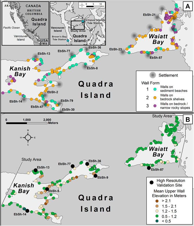
FIGURE 1. Clam gardens are found throughout the Pacific Northwest coast, from Alaska south to northern Washington State (A, left inset). Some areas like Kanish and Waiatt Bays on northern Quadra Island, British Columbia, have exceptionally high densities of clam garden features along the foreshore (A). The three forms of gardens (see text for further explanation) are interspersed with many archaeological settlement sites, reflecting a densely occupied landscape (Radiocarbon dated settlements used in this study are designated with their site number.) (B) The tops of the clam garden walls are at different tidal heights (meters above chart datum (Lower Low Water Large Tide [LLWLT]) that can be used to infer relative age. Locations of high resolution validation sites are shown in black dots with associated archaeological site numbers.
Unlike many other traditional management practices, clam gardens provide material evidence that allows the study of variety of aspects of past management systems, including age. Radiocarbon dates from excavated clam gardens on northern Quadra Island in British Columbia, Canada (Figure 1)—the focus of this paper—suggest coastal peoples began building clam gardens at least 3,500 years ago (Smith et al., 2019). Archaeological and paleoecological data from Quadra Island demonstrate that clam gardens enhanced clam growth and thus, food production, for millennia (Groesbeck et al., 2014; Toniello et al., 2017).
While the efficacy of collecting radiocarbon dates from various spatial contexts within clam gardens has been demonstrated as a valid method for determining clam garden age (Smith et al., 2019), the logistics associated with excavating clam gardens limits the utility of this approach at broad spatial scales. This is because in most parts of the Northwest Coast, clam gardens can only be excavated during the extreme low tides (i.e., <60 cm above chart datum, Lower Low Water Large Tide [LLWLT])–which occur for a total of only about 50 daylight hours in May - August. The challenges in timing are further compounded by the difficulty of finding datable material when excavating a rock wall (Smith et al., 2019). Thus, even though the clam gardens of northern Quadra Island are among the most intensively studied on the coast, extant inferences about these features in past social systems are based on a small sample of only 35 radiocarbon dates from nine excavation units spanning a total of 15 km of rock-walled terraces (i.e., 0.0006% of available walls; Smith et al., 2019; Lepofsky et al., 2020).
Here, we use a novel approach that builds on previous paleoecological, ecological, and archaeological research in this region that focused on Holocene relative sea levels (Crowell 2017; Fedje et al., 2018), distribution and age of clam gardens (Lepofsky et al., 2015, 2020, Neudorf et al., 2017; Smith et al., 2019), and the past and present productivity of clam gardens for clams and other organisms (Groesbeck et al., 2014; Salter, 2018; Cox et al., 2019; Toniello et al., 2019). In particular, we combined the shape of the relative sea level curve, clam garden wall elevations as determined by GIS and drone imagery, and our field observations, to assign proxy ages for the clam garden walls of different tidal heights in Kanish and Waiatt Bay on northern Quadra Island (Figures 1, 2). These data, combined with our previous mapping and dating of settlement sites, allowed us to examine the relationship of this ancient marine innovation to local settlement histories. Together, this analysis provides insights into the central role that cultivating clams in clam gardens played in past food systems and their potential to do the same in current and future contexts.
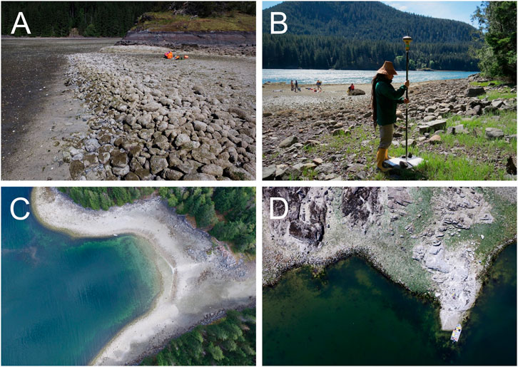
FIGURE 2. (A) Form one clam garden with terrace wall built on already existing clam habitat. (B) Real time kinematic survey prior to drone based imagery collection (C) High level survey view of a clam garden feature at settlement and clam garden site EbSh-5 in Kanish Bay, showing entire shore lined by clam garden rock walls. (D) Low level survey of a Form two clam garden in Waiatt Bay.
Study site
Kanish and Waiatt Bays lie today within the traditional territories of the Northern Coast Salish and Laich-Kwil-Tach peoples. These large bays encompass many small bays and inlets that would have provided ideal locations for settlement (Figure 1A). The coastline is densely populated with large archaeological sites characterized by terraces formed from shell midden. These settlements shifted their locations seaward as sea levels dropped through time creating multi-terraced landscapes with the older occupations often in the back of the site (Crowell 2017). Except in extreme storms, all settlements within each bay could be easily accessed via canoe, while people living in the two bays were likely in frequent contact via a short overland trail or portage. Entering Waiatt Bay requires passing through narrow passages that experience rapid and dangerous tidal currents. Because of these narrows, the timing and magnitude of the tidal cycles differs between the two bays. As we explain below, these differences in tidal regimes, as well as our limited validation surveys in Waiatt Bay, precludes us from doing detailed analyses of wall elevations through time in Waiatt Bay or from making detailed temporal comparisons with Kanish Bay.
The archaeological context
Little is known about the culture history of Quadra Island and neighbouring islands. The area received a small amount of attention in the 1980s (Mitchell 1988, 1990; Mitchell and Donald 1988) which was not enough to establish a specific regional sequence. Quadra Island falls between two areas with better known sequences, the Salish Sea to the south which is relatively well documented, and the Johnstone-Queen Charlotte Strait region to the north which is more sparsely known. Given the specificity of local histories, and the differences in the documented culture histories for these two neighbouring regions, we cannot extrapolate from them to the archaeological record of the study area.
In addition to the clam garden and settlement research presented here, the main focus of research in the study area has been on the early post-glacial to mid-Holocene with a particular focus on modelling of paleoshorelines in search of early sites (Fedje et al., 2021a,b; Lausanne et al., 2021). In general, that research shows that people were settling on northern Quadra Island ∼13,000 years ago (Fedje et al., 2018, 2016). Technologically, these people used a prepared core and bifacial technology that is similar to elsewhere on the Northwest Coast as a whole (Fedje et al., 2021b).
The archaeological record of the mid-to late Holocene is less well known. Like the rest of the Northwest Coast, the current shoreline is dotted with shell middens of various sizes, with the larger ones sculpted by human-created terraces and depressions that were the foundations for houses and other structures. Intertidal surveys elsewhere in the broader region have revealed numerous wooden fish traps which—together with the clam gardens reported here—reflect the extent and continuity of marine resource management through time and its importance in past social-ecological systems. Importantly, the limited zooarchaeological analysis for shell middens from Quadra (unpublished data) demonstrate that on Quadra Island, like much of the Northwest Coast, butter clams and Pacific littleneck clams—the focus of cultivation in clam gardens—by far dominate the invertebrate zooarchaeological record. The data on settlement patterns presented here significantly augments our understanding of the long-term social and ecological relationships among the ancestral people of Kanish and Waiatt Bays and their land- and seascapes.
The clam gardens of Northern Quadra Island
Quadra Island, like most parts of the British Columbia coastline, has experienced dramatic area-specific changes in relative sea level since the beginning of the Holocene due to eustatic and tectonic processes (Crowell 2017; Fedje et al., 2018); these changes can be used as the foundation for determining proxy ages for clam gardens. When clam garden technology was initiated some 4,000 years ago in Quadra Island, sea level continued to drop significantly until about ∼1700 years ago. After that time, sea level declined gradually until it reached current levels in the last several hundred years (Figure 3A). Thus, clam gardens built 4,000 years ago at the lowest intertidal zone are today situated well above the zone in which clams survive (Figures 3B,C).
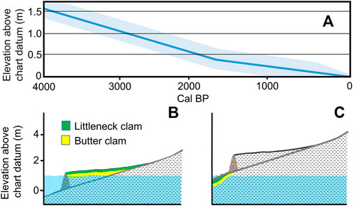
FIGURE 3. (A) Late Holocene sea level curve for northern Quadra Island, British Columbia, Canada presented with 25 cm error band around the mean to reflect errors introduced by the method of measurement and wall auto compaction (refer to Crowell 2017 for details). Note the change in slope roughly 1,700 years ago. (B) 4000-year-old clam garden during a 1.0 m tide 4,000 years ago showing the zone in which butter clams (yellow) and littleneck clams (green) could have been harvested. (C) Today, because of dropping sea levels in the study area, this same garden sits well above the zone in which clams grow. The height of the terrace wall above chart datum is a relative indicator of its antiquity.
The shorelines of Kanish and Waiatt Bays contain among the highest density of clam gardens on the Northwest Coast, with over 15 km of clam garden rock walls (∼33% of the total shoreline; Lepofsky et al., 2020). The ancestral peoples of these bays built a walled clam garden terrace in any area that could be transformed (i.e., is not a bedrock cliff or a fine sediment beach at the mouth of a significant stream). The garden walls have three forms which often occur in combinations along a bay or stretch of shoreline (Figure 1A; Lepofsky et al., 2015; Smith et al., 2019): those built on soft sediment beaches that already supported clam habitat (Form 1; Figure 2A); those built on bedrock shelves with little to no prior clam habitat (Form 2); and those built on steep eroding boulder slopes also with little to no prior clam habitat (Form 3). The extent to which the Kanish and Waiatt Bays landscapes have been transformed by clam gardens reflects the importance of these innovations not only in past food security, but also the governance systems that managed these systems over the generations, and the knowledge embedded within these ancestral management practices.
All gardens were built by placing rocks at the lowest intertidal at the time of construction until they formed a rubble wall behind which sediment was deposited via wind and waves. The deposition of sediment and broken shell was also augmented by people (Hul’q’umi’num’ Treaty Group 2011). Our understanding of these walls, based on our excavations, optical dating (Neudorf et el. 2017), and traditional knowledge (e.g., Deur et al., 2015), is that walls were built gradually over generations. Over time, as people continued to place rocks at the lowest intertidal, a wall and terrace was created that was near the optimal tidal height for growth and survival of littleneck and butter clams [∼1.0–1.6 m (Groesbeck et al., 2014; Jackley et al., 2016)]. As we discuss further below, the current height (i.e., from base to top of wall) of some the walls today supports the notion that wall height increased slowly through time. Through time, as sea levels dropped and clam habitat moved seaward, people would have had to refurbish and move the walls seaward, or build entirely new walls, to maintain access to zones of optimal clam habitat.
Our previous archaeological investigations demonstrated that clam gardens started being built at least 3,500 years ago in Kanish and Waiatt Bays (Smith et al., 2019). While we had retrieved dates suggesting the walls could be centuries older, we assigned ages to individual gardens based on conservative criteria that we felt would not overestimate age. These criteria included giving primacy to the most recent shell date found below a wall, even though we often had older samples from other excavation trenches within the same wall. As demonstrated by our on-going work, including that presented here, wall transects can have different taphonomic histories and ages and thus this criterion alone is not sufficient reason to discount a date. Also, our conservative criteria did not consider the broad and overlapping error ranges of the radiocarbon calibrations on the shell samples, which vary from 350–495 years. To avoid imposing false precision on data that has broad error ranges, and in recognition of the fluid nature of clam garden construction, use, and maintenance, we include all radiocarbon dates here from below single walled gardens.
Methods
Field survey of wall heights
To estimate ages of the clam gardens in our study area, we used high precision aerial mapping to determine wall heights in meters above Canada chart datum, lowest low water large tide (LLWLT). We conducted aerial surveys of the 44 km of shoreline in Kanish and Waiatt Bays during the daylight low tides, on May 7th–ninth, 2016 and August 22nd-23rd, 2017. Imagery was collected using a DJI Phantom three Pro drone (i.e., a Remotely Piloted Aerial System [RPAS]) when the tide was <80 cm above chart datum. Two RPAS survey types were conducted: high-level surveys at 250 m altitude, which resulted in data with a resolution of 8–10 cm across the entire study area; low-level surveys at 40–75 m altitude, which provided 1–3 cm resolution data for seven smaller study locations (Figure 1; Figures 2C,D). The high-level surveys were used to capture clam garden wall data to ensure consistency across all areas, and the low-level surveys were used to validate and ground truth our findings.
In preparation for the RPAS survey, 60 cm square checkered ground control targets were dispersed throughout the study areas (Figure 2B). Thirty-one ground control targets were used for the high-level surveys and 67 ground control targets were used for the low-level surveys. The ground controls were surveyed using a Topcon GR5 real-time-kinematic global navigation satellite system. Vertical measurements used the HTv2.0 geoid and horizontal coordinates in NAD83 (CSRS) reference frame. Root-mean-square-error of vertical accuracy was calculated to be less than 1.5 cm for all surveys conducted. The high altitude RPAS survey followed the shoreline with two offset flight lines along the entire Kanish and Waiatt Bays shore, resulting in 4,056 images collected. The seven low altitude study areas utilized a grid flight pattern at 40–75 m and 4,024 photos were collected. The resulting models represent a near-absolute representation of the clam gardens, with 1–3 cm spatial resolution and the high density of ground control targets allowed us to validate our high-altitude data products.
Determining wall elevations
We employed structure-from-motion software which uses feature matching geometry between overlapping imagery to create three-dimensional elevation maps (Carrivick et al., 2016). Pix4D photogrammetry software was used to process all drone and survey data. Orthomosaic imagery was created from motion-based images and digital elevation models. The open intertidal environment around Quadra Island is ideal for making elevation models based on RPAS imagery because it is visually complex yet structurally simple. The resulting data showed the clam garden rock walls could be clearly identified in both the high and low-level surveys. The survey ground control targets were used to align the orthomosaics and terrain models. The low-level high-resolution surveys were smaller in area with a higher concentration of ground control targets, resulting in high fidelity to the real world. The high-level surveys were horizontally accurate but had vertical errors in areas of low ground control target density. We augmented the ground control targets by creating virtual control points based on tidal height at the time of the drone image capture survey.
The high-resolution orthophotos and digital surface elevation models created from the RPAS data were analyzed using ArcMap Desktop version 10.8 (ESRI) software. A total of 204 wall lengths delineated by topographic breaks or a change in clam garden form were digitized using air photo and elevation model interpretation and observational field data. RPAS derived elevation models clearly detail the linear topographic wall and clam bed features.
We manually digitized the bottom and top of the wall along each transect to determine their elevations. The bottom of the wall is defined as the base of the incline where the steep rock wall intersects with sediment or bedrock. In some Form two and three walls, we had to truncate the bottom of transect because the wall base was too deep for the model to assess elevation. The top of wall transect points were digitized to the beginning of the clam garden bed sediment, just landward of the rock wall. To characterize the wall elevation along the rock walls, we initially placed sample points perpendicular to the rock walls at 20th percentile lengths. This mostly resulted in four transects per contiguous wall, however additional transects were measured on walls greater than 100 m in length and on walls associated with archaeological sites (e.g., Figure 4). In total, 814 transects were measured.
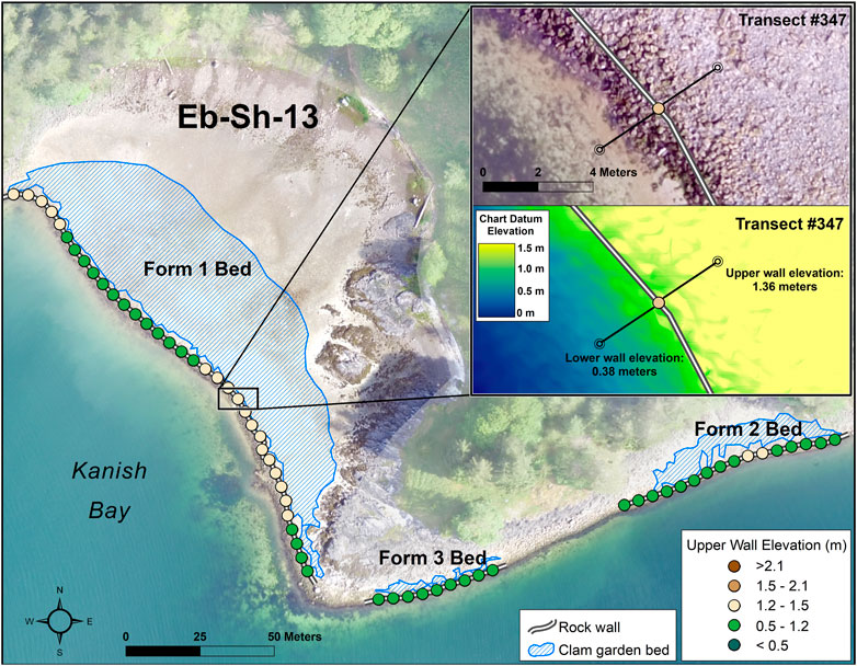
FIGURE 4. Site Eb-Sh-13, showing imagery and elevation model used to create sampling transects.
However, digitizing on the 20th percentile length meant that many more transects were measured per unit length on short walls than long walls; thus, tallying the 20th percentile transects would not give an accurate summary of the lengths of walls at different elevations. Since we aimed to use length of wall and garden bed area as our measures of ancient clam building effort (see below), we interpolated wall elevations between each transect at 5-m intervals. This served not only to eliminate the bias introduced by our sampling effort, but also meant that anomalous wall heights (e.g., a short wall resulting from a fallen rock) would be averaged out over the length of the wall segments. This resulted in 2,887 5-m interpolated wall height measurements. We refer to these measurements as “wall elevation samples”. Enumerating these wall elevation samples gives a proxy measure for wall length of different tidal heights though time. From these data, and in combination with our previous analysis of clam garden spatial data (Lepofsky et al., 2020), we also examine changes in area of clam beds and total length of terrace walls at different tidal heights through time.
To compensate for elevation distortions generated by greater distances to ground control targets, we used local minute resolution chart datum data paired temporally with the RPAS imagery time stamps to correct the transect elevation at every transect. The Canadian Hydrographic Service (CHS) provided chart datum data for Kanish Bay and Waiatt Bay separately. To estimate rock wall heights in Kanish Bay we used the nearest chart datum station of Browns Bay along with the low altitude surveys to validate the high-level models. Validation was performed by extracting chart datum elevations at seven high resolution sites (Figure 1B). 92 validation transects at these seven sites were used by subtracting the difference between top and bottom wall elevations resulting in a mean vertical accuracy of <10 cm between the high and low altitude data.
To estimate rock wall heights in Waiatt Bay, we used a model derivative chart datum for the Octopus Islands provided by CHS. One high resolution validation site and 25 transects were used for Waiatt Bay which showed high fidelity within our elevation models but revealed an estimated 65 cm discrepancy between chart datum and the measurements based on the vertical datum used for surveys in Canada (HTv2.0 geoid). This discrepancy, which is likely due to the differences in tidal regimes, subsidence, and shoreline geography between the two bays, makes comparisons between Kanish and Waiatt walls challenging without further survey data. Because of these unresolvable discrepancies, we report measurements for both bays, but conduct detailed time-elevation analyses only in Kanish Bay.
Assigning ages to wall heights, wall length, and garden area
Our analysis of the historical role of clam gardens in Kanish and Waiatt Bays is based on two fundamental assumptions. First, based on our ecological understanding of clam productivity, we assume that the maximum elevation of the top of walls fronting clam garden terraces will be determined by the tidal height in which butter clams have the greatest growth and survival rates (∼1.3 m; Jackley et al., 2016). Littleneck clams have a wider tidal range and flourish higher in the intertidal than butter clams. Thus, butter clam preferred tidal ranges provide an upper limit for the tidal height of a clam garden that would support an abundance of both species of clams. Our second assumption is that to access these tidal zones as local sea level fell through time, people had to reposition or refurbish the clam garden terrace wall. Thus, ordering these wall tidal heights will provide a proxy relative age for clam garden terrace walls.
Based on the ecologically driven assumption that the elevation of the top of the wall fronting the terrace is correlated with sea level and that sea level has dropped through time, we assigned wall and terrace age to wall tidal height. To do so, we ordered all the tops of the wall transects in both bays from tallest to shortest based on height above chart datum. To ensure that the wall height measurements today represent closely the terrace elevation at the time of use, we eliminated from this analysis sections of beaches within 20 m of two or three parallel, multi-tiered walls since older walls may have been deconstructed to build younger walls. We also eliminated walls whose beaches have been dramatically affected by industrial disturbance (fish farming, logging). In both cases, the current wall tidal elevations will be lower than when the terrace was in use and thus, poor age proxies. Removing these beach sections resulted in a total of 2,642 rock wall elevations samples that were analyzed further.
Ordering the top of wall elevations within each bay provides relative ages for the transects. We used top (rather than bottom) wall measurements because 1) they are our most reliable estimates; 2) the top of wall creates a terrace at a specific tidal height that influences clam productivity; and 3) while in many cases the bottom of wall elevations are near to the low-low water line at the time of wall construction, the bottom of walls can also be influenced by the topography of the ocean floor. This is, if there is a steep drop off near the beach (as is the case in many Form two and three clam gardens), the rocks can roll well beyond the lowest tide mark.
We also enumerate the total length of walls and clam garden area at particular tidal heights. These measurements have the potential to provide proxies for the relative amount of shoreline converted to clam gardens. This in turn provides an estimate of the amount of effort put into clam gardening at different times in the past.
As mentioned, the tidal elevations in Kanish Bay have been verified and thus the top of wall measurements are accurate estimates of the “true” tidal elevations. In Waiatt Bay, however, where the tidal elevations were collected using modelled chart datum data and were not verified through survey methods, the distribution of wall heights should be seen as relative measures. That is, the Waiatt Bay tidal heights will be internally consistent as relative temporal indicators but cannot be compared directly to our measurements in Kanish Bay–where we have absolute radiocarbon dates with which we can anchor our temporal sequences.
To assign temporal ranges to the Kanish Bay walls, we used eight radiocarbon dates presented in Smith et al. (2019) from four discrete clam gardens (Supplementary Table S1). Since our previous research was focused on dating older sites (i.e., those higher in the intertidal), our sample of radiocarbon dates is biased towards the beginning of the clam garden sequence. In the current analysis, we consider radiocarbon determinations that we discounted in the 2019 paper. In 2019, we conservatively eliminated the older two or three dates from a single beach even though they were from separate excavation trenches. Our 2019 criteria did not consider that different wall segments could have been initiated at different times, nor did it consider the overlapping error ranges of the radiocarbon dates. Here, we included the dates previously rejected on those grounds. However, we excluded from this analysis the samples from the multi-terraced beaches because using rocks from old walls (higher up in the intertidal) to make new walls would have altered the height of the older walls, thus making the top of wall elevations poor proxies for age.
We used a mix of inferences to determine fuzzy temporal ranges for the height-ordered clam garden wall transects in Kanish Bay. Because cultural choices and various natural taphonomic factors such as auto-compaction of sediment under the wall will affect the tidal height of a wall, and because our radiocarbon determinations have large error ranges, our aim was to assign broad temporal categories to the ordered wall elevations. We start with eight previously collected radiocarbon determinations for garden walls from Smith et al. (2019; Supplementary Table S1). The median calibrated ages of these walls (rounded to the nearest 10 years) provided absolute temporal anchors for the ordered wall elevations between ∼3,800–3,170 years ago (N = 6 overlapping calibrated dates) and between 1,690–1,630 years ago (N = 2 overlapping calibrated dates). We note, however, that the radiocarbon ages provide dates for wall initiation, whereas the top of wall inferred ages reflect time of final construction. Thus, the top of terrace wall inferred ages will be some unknown amount of time younger than the below-wall dates.
We created time ranges for the wall elevation samples in several sequential steps. We first created a time range that encompassed the undated walls falling within the tidal heights encompassed by the 3,800–3170-year-old radiocarbon dated walls. Walls with elevations higher than the highest dated wall in this time range were placed into a pre-3800-years time range. Wall elevations lower than the lowest dated wall in this time range were placed in the next time range, with the end of the range defined by the walls with median ages 1,690–1,630 years ago. Finally, we split the remaining elevation-ordered wall samples into two groups by subjectively assigning the lowest elevation walls to the last 300 years. These walls are those that are one-rock high and today sit in the lowest-most intertidal zone (i.e., with the ocean lapping on the rocks during the lowest-low tides). In the field we identified these rock alignments as unfinished walls that had minimal sediments accumulated behind them to create a terrace. We surmise that these alignments were placed since European contact (i.e., post 1780s) and remain unfinished because of a myriad of colonial disruptions to traditional management systems.
By using our previous spatial analyses of clam garden Kanish Bay (Lepofsky et al., 2020), we could also partition total wall length and area of garden into approximate age ranges. These estimates of wall length and area are additional measures of the effort put into clam management in clam gardens. The area measurements in particular are useful proxy measures of the potential food produced from these gardens through time.
Settlement histories
Locations and ages of shell midden sites were collected as part of a study to assess subtle changes in sea level in the mid- and late- Holocene (Crowell 2017). For that study, we primarily dated the basal deposits of sediment cores to determine the relationship between site location and past sea levels. To understand settlement histories, at some sites we also dated upper deposits. We focused our sampling on large sites, although some smaller sites were also dated (Figure 1A). Based on size and presence of terraced house platforms, we surmise that the larger shell midden sites were substantial settlements, possibly occupied year-round. The smaller shell midden sites are more likely “camps”, used for more limited activities.
Results
Wall elevations in Kanish and Waiatt Bays
We found the top of wall measurements among our initial transects within beaches were relatively consistent (Supplementary Figure S1). This internal consistency justifies the use of the original transect measurements as the basis for interpolating the RPAS elevation models and sampling wall elevations every 5-m to create the “wall elevation samples”. Internal variation within some gardens may be due to wall refurbishing or natural processes such as compaction of sediments below the walls. Different garden forms tend to have different amounts of variation along the top of wall measurements, with Form three gardens having the least amount of variation (median std dev Form 1: 0.16 m; Form 2: 0.24 m; Form 3: 0.12 m). In general, the tighter range of measurements in Form three gardens is likely due to the shorter digitized length of these features, whereas the longer length of Form two gardens resulted in more variation in measurements. Similarly, Form one gardens tend to be located within expansive, soft sediment beaches that are longer than Form three gardens.
At the scale of Kanish and Waiatt Bays, there is considerable variation in wall elevations (Kanish: min-max = 0.21–2.51 m Waiatt: min-max = 0.13–1.78 above chart datum) which we surmise largely represent different ages of use or localized tectonic influences that may vary between bays (Fedje et al., 2021b; Figure 5; Supplementary Figure S1). Disregarding the difference in tidal heights between the two bays, we note both bays display different distributions in top of wall elevations, especially in the latter two thirds of the sequences. In particular, changes in top of wall elevations in Waiatt Bay are minimal, whereas Kanish Bay elevations decline more dramatically over that same tidal height ranges. The majority of walls in Waiatt Bay are also at lower intertidal heights.
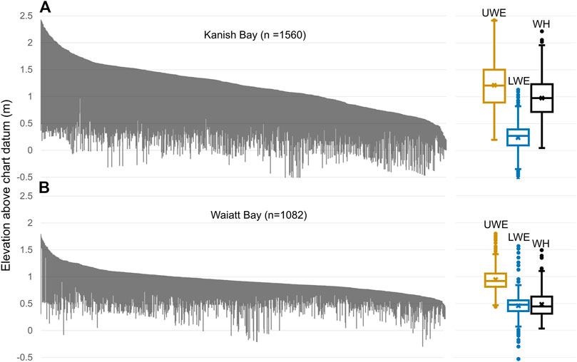
FIGURE 5. Kanish Bay (A), n = 1,560 and Waiatt Bay (B), n = 1,082 wall elevation samples arranged from highest upper wall elevation to lowest above Canadian chart datum (Lower Low Water Large Tide; LLWLT). Each vertical grey line represents an upper and lower elevation of a 5-m length of wall. For the boxplot summaries, UWE = Upper wall elevation, LWE = Lower wall elevation, WH = Wall height. Note the higher median elevations and wall heights in Kanish Bay relative to Waiatt Bay. Thus, while we can compare differences in the overall shape of the plots, we cannot make inferences about change through time between the two bays.
While many of the terrace walls at the end of our sequence were not yet built to the upper optimal tidal height for butter clam growth and survival (∼1.3 m above chart datum; Jackley et al., 2016), it is likely that the walls still provided ecological and logistical benefits. Potential benefits include increasing larval clam entrainment, recruitment, and post settlement survivorship. In addition, even walls at lower tidal heights would have increased the tidal window, or length of time, in which clams were accessible for harvesting (Lepofsky and Salomon, Forthcoming).
While all three forms of gardens are found in both bays (Figure 1B), they are distributed in different relative numbers (Figure 6). In Kanish Bay the landscape is dominated by Form one clam gardens (Figure 6A), whereas Form one gardens are relatively rare in Waiatt Bay (Figure 6B). These differences are largely due to underlying geology since there are fewer sandy beaches and more bedrock shelves in Waiatt Bay than Kanish Bay. Our GIS analyses and field observations demonstrate that the Waiatt Bay foreshore is dominated by rocks (81% of foreshore), whereas Kanish Bay foreshore is roughly an equal mix of rocky and soft sediment substrate.
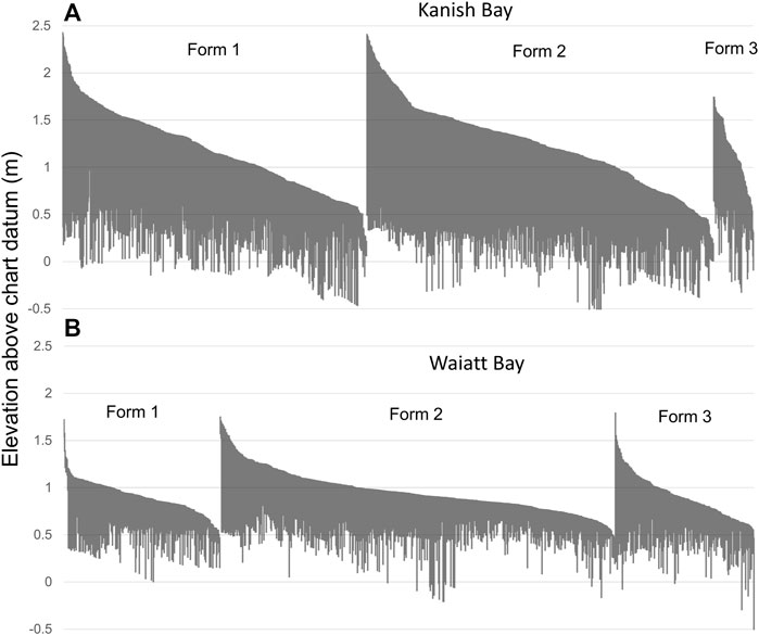
FIGURE 6. Kanish Bay (A) and Waiatt Bay (B) wall elevation samples of Forms 1, 2, and 3 clam gardens arranged from highest upper wall elevation to lowest above Canadian chart datum (Lower Low Water Large Tide; LLWLT), Each grey vertical line represents an upper and lower elevation of a 5-m length of wall.
Assigning ages to wall heights, wall lengths, and Garden area in Kanish Bay
Our grouping of the ordered wall elevation samples in Kanish Bay resulted in five approximate time ranges of unequal duration: >3,800 years ago, 3,800–3,170 years ago, 3,170–1,690 years ago, 1,690–300 years ago, and <300 years ago (Figure 7). Each time category encompasses wall elevations within a 50 cm range. Given that our calibrated radiocarbon determinations yielded age ranges of at least 400 years (Supplementary Table S1), and we used the median ages to anchor the sequence, our time ranges should be viewed as having approximate boundaries. Despite this, the robustness of our data set allows us to make inferences about general trends in clam garden wall construction through time.
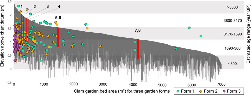
FIGURE 7. Kanish Bay bed area (m2) of the three form of clam gardens (colored dots) superimposed over the distribution of wall elevation samples (vertical grey lines) arranged from highest to lowest above Canadian chart datum (Lower Low Water Large Tide; LLWLT). Red lines represent radiocarbon dates from clams recovered from under the garden walls (Smith et al., 2019, refer to Supplementary Table S1 for details). Time divisions (grey horizontal bands) based on radiocarbon dates, the local sea level curve (Crowell 2017), and field observations.
Only a few wall samples predate the 3,800–3,170 years time range. These wall samples are sitting very high in the intertidal (2.1–2.5 m) in zones well beyond the zone where clams grow today. Possible reasons for the relative paucity of these potentially early gardens are, clam gardening was a relatively new innovation and not yet widely adopted, human population was low enough that this form of mariculture was not needed, and/or other older walls may have been destroyed by various taphonomic processes. Given that this was a time of rapidly dropping sea level, we expect frequent building and refurbishing of walls to adjust for changing tidal elevations. Regardless, if we are correct in our temporal assignments of these high elevation walls, they potentially push the date for the oldest clam garden back at least another few centuries (i.e., pre-3800).
After the initial period of clam garden construction, a substantial number of walled terraces were created in the study area until post-contact times (Figure 7), reflecting the fact that mariculture was widespread and well entrenched in the social-ecological landscape of Kanish Bay. Taking into account the different lengths of time encompassed within the time ranges, more wall elevation samples date to the period 3,170–1,690 cal BP than any other period (average wall elevation samples per 500 years for the three time ranges with begin and end dates: 3,800–3,170 = 284; 3,170–1,690 = 675; 1,690–300 = 501). These differences across time reflects greater effort put into wall construction during 3,170–1,690 cal BP than any other time range before and after.
The area’s sea level curve (Figure 3A) may in part explain the relatively lower number of wall samples after ∼1,690 years ago. There is a somewhat pronounced inflection point in the estimated sea level curve at ∼1700 cal BP, where sea level starts to drop more gradually than before this time. A more gradual change in sea level after ∼1700 cal BP meant that people would have had to put less effort into maintaining terrace walls at specific tidal elevations. That is, the minute changes in sea level characteristic of this time meant older terraces could have continued to be useful with only minor modifications in wall height. In contrast, the dramatic drops in sea level characteristic of the earlier periods would have made older walls quickly obsolete. For instance, a clam garden built 4,000 years ago would have been much less usable for clam harvesting 1,000 years later since the clam garden terrace would now be situated above the most productive clam habitat (Figure 4). Thus, even though fewer walls were being built on average during the period ∼1,690–300 years ago, it is possible that many more of the walls on the landscape were in active use than was possible in previous times.
The relationship between median sea level for each time range (Figure 8) and top of wall elevations provides insights into the relative productivity of clam gardens through time. Based on our team’s ecological experiments and observations in the study area (Groesbeck et al., 2014) and elsewhere (Jackley et al., 2016), we know that between ∼1.0 and 1.6 m above chart datum is the optimal tidal height for both butter clam and littleneck growth and survival in clam gardens. Taking into account the 50 cm error potentially associated with our estimate of ancient sea levels (Figure 3A), our data indicate that clam diggers in each time range had access to highly productive clam garden habitat as well as lower elevation gardens that also accrued other ecological benefits (Lepofsky and Salomon, Forthcoming).
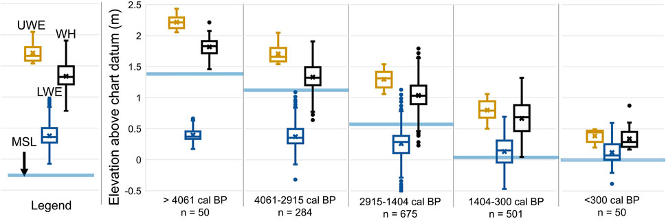
FIGURE 8. Average of top and bottom wall elevations and average wall height in relationship to median sea level per time range showing that clam garden terraces were well within productive clam garden zones. . MSL = Median sea level (horizontal blue lines), UWE = Upper wall elevation, LWE = Lower wall elevation, WH = Wall height.
Finally, wall elevation sample measurements from Kanish Bay suggests that through time there is some variation in relative abundance of the linear measurement of the three forms of gardens within time ranges (Figure 9A). When the relative area of the three clam garden forms per time is considered (Figure 9B), the clear preference for Form one gardens is evident. In Waiatt Bay, with its rockier foreshore, there are relatively more Form two gardens across tidal elevations, but we are not able to assign time ranges to these data (Supplementary Figure S2).
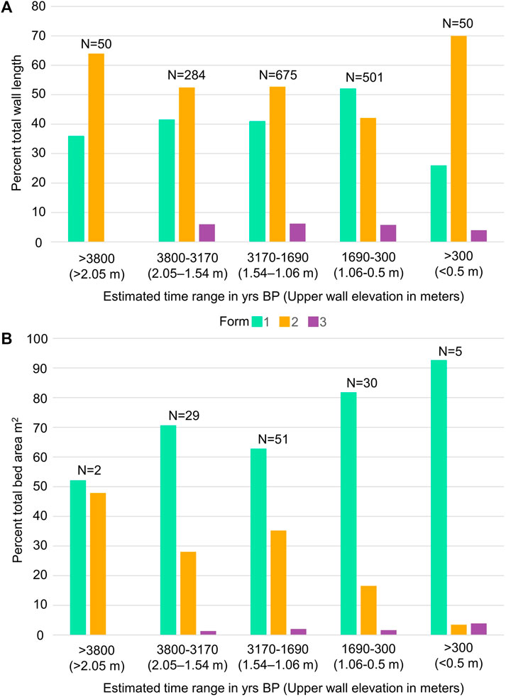
FIGURE 9. (A) Relative percent length and number of wall elevation samples (top of bars) of Forms one, two, and three clam gardens by tidal elevation in Kanish Bay (B) Relative percent area and number of clam garden beds (N = 108; Lepofsky et al., 2020) of Forms one, two, and three by tidal elevation in Kanish Bay.
Settlements histories
Our archaeological surveys indicate that both Kanish and Waiatt Bays were densely settled in the past (Figure 1A). We have radiocarbon dates from 12 settlements in the two bays, including nine sites that we judge to be substantial, permanent settlements, and three smaller sites that likely served as special purpose or short-term camps (Figure 10A; Supplementary Table S2). Our spatial coverage of sites is uneven, with a large portions of settlements in both bays remaining undated (Figure 1).
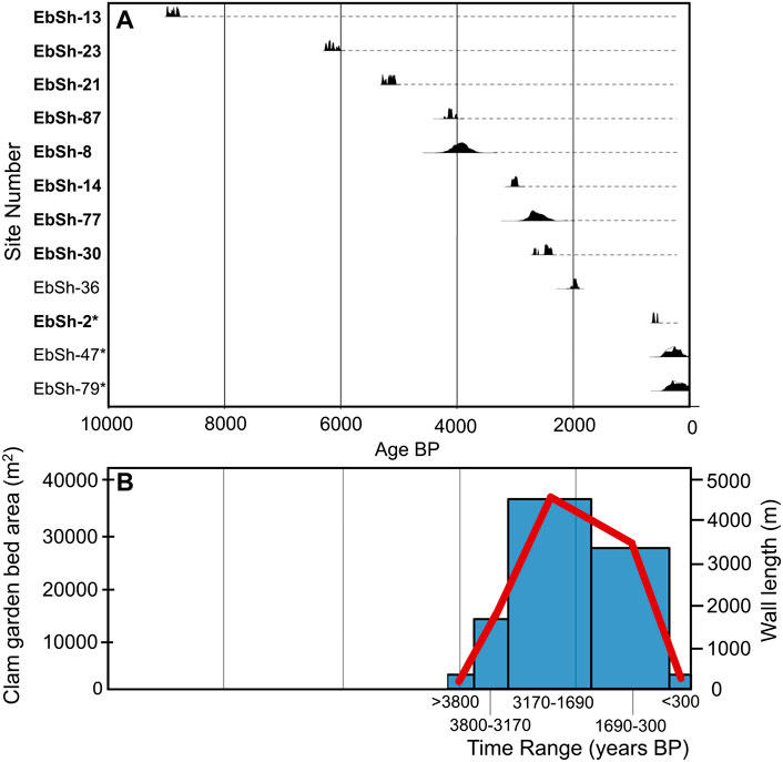
FIGURE 10. (A) Calibrated radiocarbon date ranges from basal deposits in settlements in Kanish and Waiatt Bays. Bolded site numbers are those for which we also have radiocarbon determinations from upper deposits. Based on these radiocarbon dates and stratigraphic profiles, we infer that these sites were occupied more or less continuously into the protohistoric period (dashed lines). We have no upper radiocarbon dates with which to evaluate the other sites, but assume they had similar settlement histories. Small sites are indicated with an asterisk. Dates were calibrated and plotted using OxCal 4.4 (Bronk Ramsey 2009, 2017). (B) The total length of terrace walls (red line) and garden area (blue bars) by tidal height in Kanish Bay per time range, showing the relatively greater effort put into cultivating clams in clam gardens 3,170–1,690 cal BP, and the dramatic decline in recent years. The data depicted are summed wall lengths based on previously collected spatial data (Lepofsky et al., 2020), rather than summed sample wall elevations.
By dating the basal deposits of sites, we know that the larger sites were initiated at various times in the past, but no new, large sites were built after ∼2000 cal BP. The radiocarbon determinations from the eight larger settlements for which we have upper radiocarbon dates indicate that once a settlement was established, it continued to be occupied into the early post-contact period. The three small sites in our sequence date to the last 500 years and probably into the historic period. The period beginning about 300 years ago and into the early contact period was a time of dramatic social change in the northern Coast Salish region. Central among these changes was the forced displacement and dramatic depopulation from European diseases (Harris 1994) in the post-contact era.
The placement and age of the larger settlements and their pattern of internal growth reflect the high density of occupation in the study area. Based on the current sample of radiocarbon dates and our field observations in both Kanish and Waiatt Bays, the earliest settlements were often established in prime locations that were gently sloped, not especially constrained by surrounding topography, were associated with a watercourse, and in Kanish Bay are associated with existing clam beaches that could be enhanced (i.e., Form one). The more recent sites (<∼3,000 cal BP) seem to be located in spots that are steeper and more spatially constrained, sometimes without an associated watercourse. Our limited dataset suggests that through time the larger sites expanded laterally, whereas the more spatially constrained, younger sites expanded by building terraces upslope behind the existing settlement. These internal expansion patterns, combined with the fact that new large settlements were not being established after 2000 years ago (Figure 10A) speak to the fact the landscape was densely settled with limited options for expansion. It also reflects peoples’ long-term connections to specific places as well as well-developed and highly local governance and management systems.
Discussion
Radiocarbon dates of settlement sites and the inferred temporal distribution of clam gardens suggest there was an increase in the establishment of large human settlements in Kanish Bay (and likely Waiatt Bay) ∼4,000 years ago coinciding with the initiation of clam gardens (>3,800 years ago). From ∼3,000–2000, more settlements were constructed, corresponding to our approximate temporal range of 3,170–1,690 years ago when there is an uptick in clam garden bed area and length of garden walls (Figure 10B). The increased economic and social needs of the expanding human population, combined with the dramatic changes in sea level resulting in most previous walls no longer being usable, meant that the period from ∼3,170–1,690 witnessed considerable clam garden construction and use.
Taking into account the uncertainties associated with our time ranges, the decline in new walls and in garden bed area ∼1,690 years ago likely corresponds to a time when large settlements cease to be initiated and settlements instead expand internally (Figure 10). Since the slowed rate of decline in sea level meant that previously constructed walls could have been used for longer periods with only minor adjustments in tidal height, there may have been less of a need to construct new clam gardens. However, the relative decline in clam garden construction and the apparent cessation in the establishment of new, large settlements, suggests that the communities of northern Quadra Island may have reached some kind of social-ecological carrying capacity. New gardens continued to be constructed and tended to meet the needs of the already dense human population and eventually, clam gardens were built on all the foreshore that could be converted into a terraced garden. After 300 years ago, low population numbers and the partially built, low garden walls reflect a fragmentation in a millennium-old, social-ecological system—in which clam cultivation played a central role.
The relatively greater total wall length in Kanish Bay dating to ∼3,170–1,690 is especially pronounced when we consider that our sample of clam garden walls may be biased to some degree towards younger rock walls (i.e., after 1,690 years ago). In part, this is simply because older walls would have been subject to relatively more storms over the millennia that may have disturbed the top of walls. In addition, and perhaps more importantly, we suspect that on some beaches people would have refurbished older rock walls terraces seaward as dropping sea levels changed the location of the most productive clam habitat. We especially expect this to have occurred adjacent to the oldest settlements, where an obsolete terrace wall sitting too high in the intertidal would have interfered with canoe and pedestrian access to the settlement. In beaches associated with settlements, we imagine that people continuously knocked down the height of the rock walls and then added the rocks seaward to move the clam garden terrace downslope. In both bays, this process of constant wall refurbishing is reflected by the fact that older walls are taller than younger ones (i.e., as rocks were added to the wall base, the overall height of the wall from base to top increased; Figure 5).
While we have empirical evidence for ongoing refurbishing of individual walls, we have only limited evidence to support the idea that old walls upslope were often dismantled for younger ones built downslope. Our field surveys did reveal that in some beaches with no associated settlement, there are multiple clam garden walls at different tidal elevations–indicating that obsolete terraces were left standing as newer ones were constructed downslope. However, in one of the oldest and most expansive settlements in the study area (EbSh-13, Supplementary Table S1), our admittedly limited excavations in the clam garden wall and associated terrace did not reveal older landward walls. Rather, both trenches produced overlapping dates, suggesting a narrow window of time in which the wall was constructed or reconstructed. Similarly, our multiple excavations into other clam garden terraces have not revealed prior walls. Thus, we cannot evaluate the extent to which our sample of garden walls is biased towards younger gardens.
Parsing out the temporal relationship among the three clam garden forms built on different substrates has the potential to provide additional insights into the social and ecological underpinnings of clam gardening through time. We hypothesize, based on our understanding of the local topography and observations of clam productivity, that the three forms differed in terms of effort invested in construction and maintenance (input) relative to clam productivity (output). In particular, we suggest that Form one gardens were the most productive overall, followed by Form two gardens. While the latter gardens are often quite small (and thus required considerable labour per unit area to create), they tend to be highly productive. Based on our observations, Form three gardens—which are narrow terraces along the boulder slopes—would have required the most on-going effort to keep clear of fallen rocks and maintain productivity. A reasonable hypothesis is that through time, as populations and food needs increased, people needed to put more labour into food production; this would mean that Form three gardens should be added later in temporal sequences than the other two clam garden forms. The relatively greater area of Form one gardens through time suggests a preference for these potentially lower-cost gardens. While the relatively rockier foreshore in Waiatt Bay precluded extensive construction of Form one gardens as in Kanish Bay, the preference for Form two gardens over Form three gardens in Waiatt Bay also conforms to our predictions. Going forward, the relationship between labour input and food output in these three forms needs to be evaluated empirically with field surveys and experiments.
For at least 3,800 years—almost 200 generations—the Indigenous Peoples of northern Quadra Island tended clams in clam gardens to create resilient, accessible, and productive food systems. These food systems not only nourished people, but were foundations of social systems that cemented connections across generations as well as relations with other groups through trade. These relations were sustained by on-going decisions about where and how to build gardens so that they provided the greatest ecological and social benefit. While the details of these decisions are no longer known, the very presence and abundance of garden walls in different locations and at different tidal heights, reflect some of these now forgotten conversations.
In many ways, our exploration of clam gardens in Kanish and Waiatt Bays highlights the complex and intertwined social and ecological underpinnings of ancient food systems, including management of the relationships between people and clams. Understanding the long-term context of these ancestral management systems is foundational to assertions by contemporary Indigenous Peoples of their rights to manage their own food systems (e.g., Joseph and Turner 2020; Dick et al., 2022). Bringing together diverse kinds of knowledge systems is a powerful and respectful way to understand these age-old social-ecological systems and to bring this knowledge forward (Sigona et al., 2021).
Data availability statement
The original contributions presented in the study are included in the article/Supplementary Material, further inquiries can be directed to the corresponding author.
Author contributions
DL, KH, NS, TC, and AS conceived of the paper. KH, DL, NS, and TC conducted the fieldwork. KH conducted the GIS analysis; KH, DL, NS, TC, and AS analyzed the other data. DL, KH, NS, TC, and AS wrote the paper.
Acknowledgments
We respectfully acknowledge the Northern Coast Salish and Laich-Kwil-Tach Nations in whose traditional lands and waters this research took place. We are grateful to the many members of the Clam Garden Network (www.clamgarden.com) for sharing their excitement and knowledge about traditional mariculture practices. Louie Wilson, Christine Roberts, Will Hall, and Will McInnes provided invaluable help in the field and during the analysis of the data. Many thanks to Eric Peterson and Christina Munck of Tula Foundation for their on-going logistical, financial, and intellectual support of clam garden research. Thank you also to Marlene Jeffries at the Canadian Hydrographic Service for providing valuable tide station data.
Conflict of interest
Author TC is employed by Davis MacIntyre and Associates.
The remaining authors declare that the research was conducted in the absence of any commercial or financial relationships that could be construed as a potential conflict of interest.
Publisher’s note
All claims expressed in this article are solely those of the authors and do not necessarily represent those of their affiliated organizations, or those of the publisher, the editors and the reviewers. Any product that may be evaluated in this article, or claim that may be made by its manufacturer, is not guaranteed or endorsed by the publisher.
Supplementary material
The Supplementary Material for this article can be found online at: https://www.frontiersin.org/articles/10.3389/feart.2022.988111/full#supplementary-material
Supplementary Figure S1 | Variation in 20th percentile wall transects of tidal heights within discrete clam gardens in Kanish Bay after disturbed walls have been removed from the dataset.
Supplementary Figure S2 | Relative percent and number of wall elevation samples of Forms one, two, and three clam gardens by tidal elevation in Waiatt Bay.
References
Bronk Ramsey, C. (2009). Bayesian analysis of radiocarbon dates. Radiocarbon 51 (1), 337–360. doi:10.1017/S0033822200033865
Bronk Ramsey, C. (2017). Methods for summarizing radiocarbon datasets. Radiocarbon 59 (6), 1809–1833. doi:10.1017/RDC.2017.108
Caldwell, M., Lepofsky, D., Combes, G., Harper, J., Welch, J., and Washington, M. (2012). A bird's eye view of Northern Coast Salish intertidal resource management features, southern British Columbia, Canada. J. Isl. Coast. Archaeol. 7, 219–233. doi:10.1080/15564894.2011.586089
Carrivick, J. L., Smith, M. W., and Quincey, D. J. (2016). Structure from motion in the geosciences. Oxford, UK: Wiley-Blackwell.
Cox, K. D., Gerwing, T. G., MacDonald, T., Hessing-Lewis, M., Millard-Martin, B., Command, J. R., et al. (2019). Infaunal community responses to ancient clam gardens. ICES J. Mar. Sci. 76, 2362–2373. doi:10.1093/icesjms/fsz153
Crowell, T. (2017). “Refining local sea-levels through settlement change in Kanish and Waiatt bays, Quadra Island,”. M.A. thesis (Burnaby, BC: Department of Archaeology, Simon Fraser University).
Deur, D., Dick, A., Recalma-Clutesi, K., and Turner, N. J. (2015). Kwakwaka’wakw “clam gardens”. Hum. Ecol. 43, 201–212. doi:10.1007/s10745-015-9743-3
Dick, A., Sewid-Smith, D., Recalma-Clutesi, K., Deur, D., and Turner, N. J. (2022). From the beginning of time”: The colonial reconfiguration of native habitats and Indigenous resource practices on the British Columbia Coast. FACETS 7, 543–570. doi:10.1139/facets-2021-0092
Fedje, D., Abbott, C., Lausanne, A., Mackie, A., Mackie, Q., McLaren, D., et al. (2021b). Discovery Islands landscape archaeology research project – 2014 to 2018 final report. Volume 1, HCA permit 2014-0046, BC Parks permit 107261. Victoria, BC: Report of file with the BC Archaeology Branch.
Fedje, D., Lausanne, A., McLaren, D., Mackie, Q., and Menounos, B. (2021a). Slowstands, stillstands and transgressions: Paleoshorelines and archaeology on Quadra Island, BC, Canada. Quat. Sci. Rev. 270, 107161–161. doi:10.1016/j.quascirev.2021.107161
Fedje, D., Mackie, Q., Smith, N., Mackie, A., McSporran, J., Vogelaar, C., et al. (2016). Discovery Islands landscape archaeology research project annual report for 2014 field season. Canada: University of Victoria. Submitted to the Archaeology Branch of B.C., HCA Permit 2014-0046.
Fedje, D. W., McLaren, D., James, T. S., Mackie, Q., Smith, N., Southon, R. J., et al. (2018). A revised sea level history for the Northern Strait of Georgia, British Columbia, Canada. Quat. Sci. Rev. 192, 300–316. doi:10.1016/j.quascirev.2018.05.018
Fowler, C., and Lepofsky, D. (2011). “Traditional resource and environmental management,” in Ethnobiology. Editors E. N. Anderson, Deborah M. Pearsall, Eugene S. Hunn, and Nancy J. Turner (Hoboken: Wiley-Blackwell), 87–306.
Groesbeck, A. S., Rowell, K., Lepofsky, D., and Salomon, A. K. (2014). Ancient clam gardens increased shellfish production: Adaptive strategies from the past can inform food security today. PLoS ONE 9, e91235. doi:10.1371/journal.pone.0091235
Grone, M. A. (2022). Of molluscs and middens: Historical ecology of Indigenous shoreline stewardship along the Central Coast of California. PhD dissertation. Berkeley: Department of Anthropology, University of California.
Harris, C. (1994). Voices of disaster: Smallpox around the Strait of Georgia in 1782. Ethnohistory 41, 591–626. doi:10.2307/482767
Hul’qumi’num Treaty Group (2011). Sidney, BC, Canada: Gulf Island National Park Reserve. Gulf Island National Park Reserve - Hul’qumi’num Treaty Group shellfish traditional knowledge research project.
Jackley, J., Gardner, L., Djunaedi, A., and Salomon, A. K. (2016). Ancient clam gardens, traditional management portfolios, and the resilience of coupled human-ocean systems. Ecol. Soc. 21, 20. doi:10.5751/es-08747-210420
Joseph, L., and Turner, N. J. (2020). “The old foods are the new foods!”: Erosion and revitalization of indigenous food systems in Northwestern North America. Front. Sustain. Food Syst. 23, 596237. doi:10.3389/fsufs.2020.596237
Lausanne, A. L., Fedje, D. W., Mackie, Q., and Walker, I. J. (2021). Identifying sites of high geoarchaeological potential using aerial LIDAR and GIS on Quadra Island, Canada. J. Isl. Coast. Archaeol. 16 (2-4), 482–508. doi:10.1080/15564894.2019.1659884
Lepofsky, D., and Salomon, A. (Forthcoming) “Clam gardens across generations and places support social-ecological resilience to global change,” in Climatic and ecological change in the Americas: A perspective from historical ecology. Editors J. A. Whitaker, C. G. Armstrong, and G. Odonne (London: Routledge). in press.
Lepofsky, D., Smith, N. F., Cardinal, N., Harper, J., Morris, M., White, E., et al. (2015). Ancient shellfish mariculture on the Northwest Coast of North America. Am. Antiq. 80, 236–259. doi:10.7183/0002-7316.80.2.236
Lepofsky, D., Toniello, G., Earnshaw, J., Roberts, C., Wilson, L., Rowell, K., et al. (2020). Ancient anthropogenic clam gardens of the Northwest Coast expand clam habitat. Ecosystems 24, 248–260. doi:10.1007/s10021-020-00515-6
Mannino, M. A., and Thomas, K. D. (2002). Depletion of a resource? The impact of prehistoric human foraging on intertidal mollusc communities and its significance for human settlement, mobility and dispersal. World Archaeol. 33, 452–474. doi:10.1080/00438240120107477
Mathews, D., and Turner, N. J. (2017). “Ocean cultures: Northwest Coast ecosystems and Indigenous management systems,” in Conservation for the Anthropocene ocean, interdisciplinary science in support of nature and people. Editors P. S. Levin, and M. R. Poe (London: Academic Press), 169–199.
Mitchell, D. (1988). “Archaeology and the study of Northwest Coast economies,” in Prehistoric economies of the Northwest Coast. Editor Barry Isaac (Greenwich: JAI Press), 293–351. Research in Economic Anthropology, Supplement 3.
Mitchell, D., and Donald, L. (1988). “Archaeology and the study of Northwest Coast economies,” in Prehistoric economies of the Pacific Northwest Coast. Editor B. L. Isaac (Greenwich: JAI Press), 293–351. Research in Economic Anthropology.
Mitchell, D. (1990). “Prehistory of the coasts of southern British Columbia and northern Washington,” in Handbook of North American Indians, volume 7, Northwest Coast. Editor W. Suttles (Washington: Smithsonian Institution Press), 340–359.
Neudorf, C., Smith, N., Lepofsky, D., Toniello, G., and Lian, O. (2017). Between a rock and a soft place: Using optical ages to date ancient clam gardens on the Pacific Northwest. PLOS ONE 12, e0171775. doi:10.1371/journal.pone.0171775
Pacific Sea Garden Collective (2022). Sea gardens across the Pacific: Reawakening ancestral mariculture innovations. Version 1. Seattle, United States: Washington Sea Grant at the University of Washington. doi:10.6069/ZJB9-CG30
Rakov, V. A., and Brodianski, D. L. (2010). Oyster cultivation and archaeology as producing activities. Archaeol. Ethnology Anthropol. Eurasia 38, 26–31. doi:10.1016/j.aeae.2010.05.003
Reeder-Myers, L., Braje, T. J., Hofman, C. A., Elliott Smith, E. A., Garland, C. J., Grone, M., et al. (2022). Indigenous oyster fisheries persisted for millennia and should inform future management. Nat. Commun. 13, 2383. doi:10.1038/s41467-022-29818-z
Ruddle, K, and R. E. Johannes (Editors) (1989). Traditional marine resource management in the Pacific Basin: An anthology (Jakarta: UNESCO/RPSTSEA).
Salter, N. (2018). “Ancient clam gardens magnify bivalve production by moderating temperature and enhancing sediment carbonate,”. MRM thesis (Simon Fraser University: School of Resource and Environmental Management).
Sigona, A., Apodoca, A. J., and Lopez, V. (2021). Supporting cultural obligations: Using eco-archaeology to inform Native eco-cultural revitalization. J. Calif. Gt. Basin Anthropol., 41, 207–221.
Smith, N. F., Lepofsky, D., Toniello, G., Holmes, K., Wilson, L., Neudorf, C. M., et al. (2019). 3500 years of shellfish mariculture on the Northwest Coast of north America. PLoS ONE 14 (2), e0211194. doi:10.1371/journal.pone.0211194
Thompson, V. D., Marquardt, W. H., Savarese, M., Walker, K. J., Newsom, L. A., Lulewicz, I., et al. (2020). Ancient engineering of fish capture and storage in southwest Florida. Proc. Natl. Acad. Sci. U. S. A. 117, 8374–8381. doi:10.1073/pnas.1921708117
Toniello, G., Crowell, T., Lepofsky, D., Letham, B., Smith, N. F., Neudorf, C., et al. (2017). Quadra Island clam garden and archaeological settlement project 2015-2016 fieldwork in Kanish and Waiatt bays. Victoria, BC: Unpublished report on file with British Columbia Archaeology Branch.
Toniello, G., Lepofsky, D., Lertzman-Lepofsky, G., Salomon, A. K., and Rowell, K. (2019). 11, 500 years of human-clam relationships provide long-term context for intertidal management in the Salish Sea, Canada. PNAS, 116 22106–22114. doi:10.1073/pnas.1905921116
Keywords: clam gardens, Northwest coast, traditional marine management, GIS, relative sea level, dating methods
Citation: Holmes K, Lepofsky D, Smith NF, Crowell TD and Salomon AK (2022) Ancestral sea gardens supported human settlements for at least 3,800 years on the Northwest Coast of North America. Front. Earth Sci. 10:988111. doi: 10.3389/feart.2022.988111
Received: 08 July 2022; Accepted: 21 September 2022;
Published: 26 October 2022.
Edited by:
Ximena S. Villagran, University of São Paulo, BrazilReviewed by:
Li Wu, Anhui Normal University, ChinaScott M. Fitzpatrick, University of Oregon, United States
Copyright © 2022 Holmes, Lepofsky, Smith, Crowell and Salomon. This is an open-access article distributed under the terms of the Creative Commons Attribution License (CC BY). The use, distribution or reproduction in other forums is permitted, provided the original author(s) and the copyright owner(s) are credited and that the original publication in this journal is cited, in accordance with accepted academic practice. No use, distribution or reproduction is permitted which does not comply with these terms.
*Correspondence: Dana Lepofsky, ZGxlcG9mc2tAc2Z1LmNh
†These authors share first authorship