 L. Beaulieu1A. Arreak1R. Holwell1S. Dicker1O. Qamanirq1
 L. Moorman1,2*
 K. Wilson1
 R. Segal3S. Crichton4
 T. Bell1,5
- 1SmartICE: Sea Ice Monitoring and Information Inc., StJohn’s, NL, Canada
- 2Mount Royal University, Calgary, AB, Canada
- 3Arctic Eider, Sanikiluaq, QC, Canada
- 4University of British Columbia, Okanagan Campus, Kelowna, BC, Canada
- 5Memorial University of Newfoundland, StJohn’s, NL, Canada
Inuit have lived along the shoreline of the frozen Arctic Ocean for centuries. Our wellbeing, culture, and identity are closely tied to safe and dependable ice access. As the ice becomes more unpredictable with a changing climate, Elders and experienced ice users recognize that their accumulated wisdom and experience of safe ice travel—their Inuit Qaujimajatuqangit (IQ; a term used to describe Inuit knowledge and values) of sea-ice—must be shared and applied in new ways for the benefit of younger generations. Here we illustrate one such application that enables young Inuit scientists to learn and apply the tools and skills they need to create operational community-scale sea-ice maps (Sikumik Qaujimajjuti, or “tool to know how the ice is”). Our cross-cultural partnership approach—called the Sikumiut-SmartICE model—focuses on developing the skills of young Inuit to create the maps, while non-Indigenous partners provide mentorship, tools, and training. Our novel maps incorporate culturally relevant ice terminology, on-ice monitoring data and observations, and IQ-grounded interpretations of ice features and travel conditions from near-real time optical and radar satellite imagery. The layers of data are integrated into a local GIS, enabling the creation of maps that reflect local and seasonal travel patterns and meet our information needs in information content, extent and frequency. The maps are posted and shared through social media platforms preferred by the community. The maps are a trusted source of travel information because they are made by one of our own, using local language, experience, and IQ. The Sikumik Qaujimajjuti program illustrates the incredible potential of Indigenous self-determination in cryospheric science when the scientific merit of IQ is fully recognized, when Indigenous researchers are able to access technologies and training to apply their IQ, and when non-Indigenous partners mentor and support young Indigenous scientists.
1 Introduction
Through this Perspective piece we, as Inuit scientists living and working on sea-ice, share with the cryospheric science community the value of our Indigenous knowledge, Inuit Qaujimajatuqangit, referred to as IQ (see Kalluak, 2017 for a detailed explanation) and illustrate how its application can benefit our society and fill critical ice information gaps. The authorship also includes our non-Indigenous mentors with whom we co-designed the training to realize this opportunity. We are all either staff or associates of the northern social enterprise called SmartICE (smartice.org), which empowers Indigenous communities in Canada with the tools and information we need to travel safely on ice. We begin by describing the importance of ice for Inuit and the critical role that our IQ plays in keeping us safe on the ice. We then explain why our communities asked us to create new IQ-based tools to support safe ice travel, how we went about designing a training curriculum to help us make these tools, and what feedback our communities gave us on our prototype maps. This perspective piece is a product of our reflections on our process, suggestions on how the cryospheric science community can support Indigenous self-determination within our shared discipline and how in turn, our approaches and data can advance the field itself.
1.1 Inuit Qaujimajatuqangit (IQ) and living with ice
Sea-ice is critical to maintaining Arctic ecosystem health and wildlife habitat in addition to regulating global climate (ECCC, 2021). As Inuit, we have a living connection to sea-ice, depending on it as a transportation and hunting platform. Our seasonal calendar reflects the stability and movement of the ice and our language is infused with terminology to describe dynamic and local ice features and characteristics. However, warmer air and water temperatures are shortening the ice season, as well as decreasing the thickness and spatial extent of the ice (Cooley et al., 2020). Our Inuit communities are facing rapidly changing and dangerous ice conditions for travel (Ford et al., 2019; Sharma et al., 2020). In general, our communities have noticed that the sea-ice is forming later in the season and breaking up earlier. Currents are getting stronger, and the wind is becoming less predictable in strength, timing and direction (Simonee et al., 2021). Changes in rainfall patterns and river and glacier meltwater discharge are also noticed (Inuit Circumpolar Council, 2014). Wind, currents, and freshwater input play a significant role in ice formation, which has contributed to thinner ice that is weaker and less stable than Elders remember (NTI, 2004).
Our Indigenous knowledge (Inuit Qaujimajatuqangit, IQ) specific to sea-ice, is here described as “sea-ice IQ”. IQ is not limited to knowledge that has been accumulated over generations of ice travel, but also includes our Inuit values and principles, with a recognition of the dynamic nature of knowledge and society (ICC, 2015). While safe travel practices are similar across all communities, the ice characteristics, timing, and terminology can vary considerably. Sharing local sea-ice IQ is critical to ensure that all ice users in that area are aware of the normally safe and dangerous ice conditions that vary throughout the ice season. Unfortunately the intergenerational transfer of sea-ice IQ has been interrupted by colonization, with Inuit youth being removed from their homes, families, and the teaching of Elders (TRC, 2015). The resulting loss of experiential mentorship, language, and communication between Elders and youth have created a decline in ice terminology usage and knowledge of local ice conditions and practices (Heyes, 2011). More than ever, sea-ice IQ needs to be shared with youth to ensure safe local ice travel, particularly as access to the land and ice for country food is so important (Sadowsky, 2019).
Elders and experienced ice users in our communities have responded to this need by finding new ways to share their sea-ice IQ with youth beyond the traditional ways of demonstration and practice. Information is shared through community radio reports and social media posts (eg., Facebook and SIKU) and through the creation of local illustrated ice terminology books, travel safety posters, and seasonal maps of IQ travel hazards (https://smartice.org/ice-safety/) Wilson K. J. et al., 2021a). SmartICE was asked to help with this process by training us in workshop facilitation, terminology documentation, digital mapping, and map and poster making (for details see Bell et al., 2022). This training in turn led to new opportunities to apply this sea-ice IQ, including further training to fill ice travel information gaps in our communities.
1.2 Current ice information sources and gaps
Inuit in northern communities are able to access publicly available ice charts from the Canadian Ice Service, and optical and radar satellite imagery through ESA’s EO Browser and SIKU (siku.org). SIKU is an Indigenous Knowledge Social Network platform that provides those living and working on the ice an opportunity to post information relating to ice conditions or wildlife and to see weather, tides, a range of recent satellite imagery, a satellite-derived ice roughness product, and SmartICE monitoring data and maps specific for their communities (Haavisto et al., 2020).
Programs such as SIKU and Alaska’s Sea Ice for Walrus Outlook (SIWO) (Guy, 2021) provide a communication platform to share weather and ice information products and Inuit observations. While these programs have advanced our ability to access some satellite information, significant gaps still remain in understanding how Earth observation sensors work and how to interpret images from an Inuit user perspective to help monitor ice conditions, particularly at a local level. Radar imagery is particularly challenging to interpret, but essential for monitoring ice conditions during freeze up in the winter darkness and through cloud cover during spring break-up. Current ice products, such as the Canadian Ice Service charts, are focused on safe shipping and broader scale reporting, with complicated codes and spatial and temporal scales not appropriate for community travel (Wilson et al., 2020).
With the support and guidance of our communities, and funding from the Climate Justice Resilience Fund (CJRF, 2019), we embarked on a collaborative project to design an ice travel safety map that would be produced by and for communities, at a frequency and spatial scale that matched local ice information needs. Critically, it includes IQ-grounded interpretations of ice travel conditions from available optical and radar satellite imagery, and incorporates our Inuktitut ice terminology, seasonal travel hazards, and SmartICE ice monitoring data that we collect for our communities. We called these maps and the training to make them Sikumik Qaujimajjuti, meaning “a tool to know how the ice is”.
2 Sikumik Qaujimajjuti
Before we outline the training and map-making processes, it is important that we introduce our cross-cultural partnership approach with communities. One founding principle of SmartICE is to involve Inuit in all aspects of its operation and decision-making. To this end, each community participating in this SmartICE program convenes a management committee composed of a cross-section of sea-ice users to help direct our operations and identify local ice information needs. The community management committee (CMC) in Mittimatalik (Nunavut), self-titled Sikumiut (meaning “people of the ice”), was instrumental in co-designing with SmartICE a partnership approach that supports community needs and Inuit self-determination in ice monitoring (ITK, 2018; Wilson et al., 2020). In this Sikumiut–SmartICE model, CMC members govern project activities and provide mentorship around ice knowledge, while non-Indigenous SmartICE staff train and mentor us with the technology skills to carry out the activities. CMCs are critical to ensure that the sea-ice IQ we learn, document, and share is accurate, as it provides the foundation for our interpretation of the satellite imagery.
2.1 Project goals and communities
Sikumik Qaujimajjuti is a training approach that provides us with the opportunity and ability to acquire Earth observation technologies and digital mapping skills. We then combine these with our sea-ice observations and IQ, creating timely and relevant ice travel safety maps for our communities. The IQ knowledge is recorded on paper maps through participatory mapping (Wilson K. J. et al., 2021) and digitized, becoming layers within our mapping application. Those data include areas of known dangerous ice conditions during different times of the season and safe travel routes. The near-real time satellite information provides a regional view of the current conditions - the extent and characteristics of the ice, including roughness and cracks, which is an important detail for travelers. The satellite data does not replace the use of sea-ice IQ amongst ice users, but supports mapping decisions and adds information required to adapt travel behaviour to changing ice conditions. The imagery also serves as another means of sharing and discussing sea-ice knowledge (Laidler et al., 2011; Segal et al., 2020; Bell et al., 2022).
The maps are made at spatial scales that reflect local travel patterns and are produced on a schedule consistent with local sea-ice dynamics and information needs. They are trusted by the community because they are made by one of our own using local language, experience, and IQ. These novel products offer new perspectives and terminology to describe and understand the ice, offering relevant alternatives to the traditional scientific classifications used for current ice products.
The project was piloted in our Nunavut communities of Mittimatalik, Gjoa Haven, and Arctic Bay and our Nunatsiavut community of Nain with the support of our local CMCs: Sikumiut, Qiqiqtaqmiut (“people of the island”), Tuvaliriji (“people of the landfast ice”), and Sikeusiutet (“people of the ice”), respectively. There was at least one of us in each community who participated in development of the curriculum, training, and creation of sea-ice maps.
2.2 Our co-development and training approaches
Co-development of the Sikumik Qaujimajjuti design, curriculum, and training began with a working understanding of Inuit learning principles, values, and best practices, through group activities and individual interviews. The project training was structured to allow us to engage with the work from our own communities through online video-synchronous training and mapping sessions, without moving south. While this placement was necessary due to COVID travel restrictions, it also allowed us to consult frequently with our own community members and keep local terminology, ice conditions, and safety concerns at the forefront of our training and mapping. This ensured we had the equipment and resources required to work locally. The development of a team approach, where we supported each other in the technical and interpretation aspects of the work, was considered critical to maintaining local capability beyond the project, and was integral to the overall project planning, implementation and support, and our motivation. Team interpretation of sea-ice conditions provided learning experiences for understanding radar principles, sharing common knowledge of ice conditions, and building peer-technical support. In-person workshops were critical to foster teamwork, conduct formative evaluations, and provide opportunities for on-ice ground truthing and training (Figure 1).
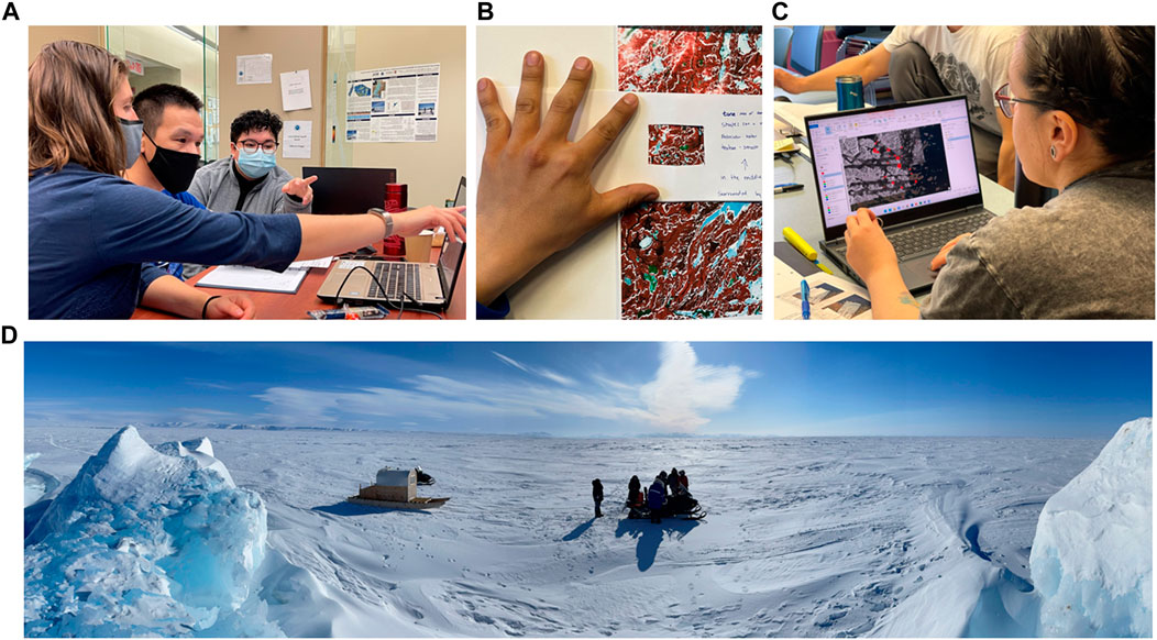
FIGURE 1. In-person workshops consisted of (A). GIS training and mentoring, (B). Hands-on remote sensing learning activities, (C). Team exercises in cartography and (D). In situ sea-ice learning and ground truthing of radar and optical images.
Two cohorts moved through four phases of training, which included sea-ice (fundamentals, IQ including local ice features and terminology), geographic information systems and cartography, introductory remote sensing and interpretation, and radar remote sensing. Our first cohort participated in the development of the design and instructional modality, and acted as peer instructors and mentors for the second cohort. This tandem approach allowed for a gradual shift to Inuit instructors, and development of Inuit contextual learning resources and peer mentoring. The subsequent leadership and mentoring provided by members of the first cohort to the second improved communication and engagement amongst the team, fostering a strong network with increasing independence from the original instructors. This shift is necessary for Indigenous self-determination and future advances in the direction of decolonization. Throughout the program, the CMC’s members continue to mentor our team on local sea-ice IQ and ice conditions (Bell et al., 2022).
An Illianajutit (learning toolkit) was developed to act as a guiding document for the instructional design of the training and the development of curriculum and resources. This toolkit is an iterative document designed to be responsive and reflective of Inuit and adult learning principles, and provides instructional planning templates (Moorman et al., 2021). A learning management system holds the course materials, interactive learning tools, assessments, and a portfolio generator of our work for our easy access.
2.3 Mapping
During the project pilot, weekly ice safety maps were generated for three of our communities for two breakup seasons and one freeze-up season. Describing the full methodology is beyond the scope of this perspective piece, however a summary description of the process follows. Early each week, we meet to discuss the area of focus and scale, based on the needs and wants of each community. These needs include, travel to particular locations for seasonal hunting and fishing, intensity of travel (travel to nearby communities), or rapidly changing ice conditions during the spring. We search for and download appropriate satellite imagery, then review any available digitized sea-ice IQ appropriate for the season. The IQ data is critical to focus our attention on potentially dangerous areas and understand where people are typically on the ice at that time. The basemap is created by adding the satellite imagery into our GIS and applying basic image enhancements. We review the imagery and IQ, and discuss and interpret the potential ice features and conditions to be mapped among our team. We digitize the sea-ice extent, ice features, and conditions, and add symbology, labels, and colors to aid in the reading of the map. In Figure 2, we illustrate two of these maps from Mittimatalik and Gjoa Haven to show how the content and style reflect local ice conditions and terminology. As shown, in Mittimatalik, the maps are produced in both Inuktitut and English to support the dual language requirements of Elders and youth in the community. Two key hunting areas are northwest and east of the community, so inset maps are added to show these areas in detail. The safety focus of this map is the floe edge (sinaa), areas of glacier and river run-off, and leads and cracks in the ice, indicating the dangerous travel conditions in the break-up season. In the Gjoa Haven map, the area of focus is to the west of the community where large areas of ice were mobile and unstable, despite being in the winter season. Moving ice, cracks, and rough ice are represented by intense colors and symbology to remind ice users to always check the ice thickness with a harpoon. Both maps use symbology created by an Inuk artist to support visual understanding of the map content, along with a legend and text description to describe the conditions.
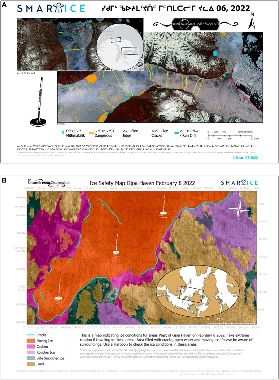
FIGURE 2. Examples of Sikumik Qaujimajjuti maps produced in 2022. (A). The June 6th Mittimatalik, Nunavut, map focussed on dangerous run-off areas, cracks, and the floe edge in two locations. The map is produced in both english and inuktitut to respond to the community desire to share the information in both languages (cartographer: A. Arreak) (B). The February 8th map produced in Gjoa Haven, Nunavut, shows the area to the west of King William Island, where rough and moving ice (orange and purple tones) could make traveling difficult and dangerous (cartographer: L. Beaulieu).
The maps are shared in preparation for weekend travel by printing and posting in our communities, and through social media, (particularly Facebook) where feedback, suggestions, and verification are gathered (see Castleton, 2016; O’Donnell et al., 2016 for importance of social media in northern communication). The maps are also accessible through SIKU, in a format similar to Facebook (as a static image within a social post). After sharing the maps, we review feedback from Facebook polls, people in our community, and our CMCs.
2.4 Community and personal benefits
As a result of the development of mapping skills and a supportive Inuit team, we now have the capacity to create locally responsive and culturally relevant maps within our own communities. Also, our peer instructor approach demonstrated that local mapping activities can be efficiently upscaled to new communities. Through the training program we gained confidence in our abilities to create sea-ice travel safety maps, and are proud to be doing this work to help our communities. The work provides an opportunity to bring us closer to our culture and connect with our community on a different level. We are also learning more about our own communities, through new perspectives from the imagery, community members, and practice honing our knowledge of local and regional ice conditions.
The Sikumik Qaujimajjuti maps contributed positively to safety outcomes in several circumstances. Community members reported checking the maps and using them to plan travel on the ice. Tour operators, in Mittimatalik and Arctic Bay, for example, reported consulting the maps before traveling to the floe edge, whereas in Mittimatalik and Nain our SmartICE operators use the maps to determine monitoring routes informed by the community input. Our operators also contribute to the mapping process, with observations and photos made during monitoring trips being incorporated into community maps.
Just last week I got a message, someone wanted to know what the ice conditions were like from here to another community that they travel to really often. I showed them the image and there was this area that was still pretty, how do you say—sketchy? So he decided he was probably going to wait a while longer until it looks better. So little things like that, it’s really nice to know that you’re making a difference and helping people stay safe out on the ice (LB, 12 Jan 2022).
3 Discussion
“It is our conviction that there is much to learn from Inuit understandings of the processes, structures, and changes in sea-ice. They understand the nuances and complexity of his dynamic environment through long-term use and occupancy, and thus Inuit sea-ice experts have a great deal to contribute to collective knowledge of physical, human, and animal relationship with marine environments (Aporta, Taylor, Laidler, 2011).
Our Indigenous knowledge is increasingly informing the field of cryospheric science, but now we are also participating in and leading the science, augmenting our sea-ice IQ with data and technology. The shift is necessary and timely, as recognized in this work. As Inuit community members and scientists, we have direct observations, community knowledge and sea-ice IQ to form the basis of our mapping, and we have excelled at interpreting subtle local ice conditions and features on satellite imagery. We also have a deeper responsibility tied to our mapping, and this is another reason we are invested in keeping our communities and people safe. These personal and Indigenous qualities all influence our mapping efforts and contributions.
Our mapping work forms an important dataset upon which ongoing monitoring can be based, with priorities and a spatiotemporal scale and scope that are unique, as we track the information most important for our travel. Our sea-ice seasons, ice conditions, and our safety concerns are community-specific, and can be quite different from one place to another. The contributions however, reach beyond our northern communities to the wider cryospheric community, providing an archive of sea-ice data and local-scale sea-ice climatology that will be available to international climate scientists for years to come, providing data for model validation and assessment.
Relying and traveling on ice to maintain our lifestyle and culture requires identifying and adapting to changing conditions. To do this we need an understanding of the ice through both the lens of our sea-ice IQ and our near-real time monitoring and mapping. The application of our sea-ice IQ, development of our mapping skills, and community management and leadership, are critical to the advancement of our own cryospheric science and the ability to use this science to protect lives and livelihoods.
4 Conclusion
In this paper we share advances in Indigenous cryospheric science through our co-design of a recent SmartICE initiative called the Sikumik Qaujimajjuti program. This responsive ice mapping initiative by Inuit for Inuit across Inuit Nunangat integrates our local IQ with near-real time satellite and monitoring data to promote ice safety and awareness throughout the ice season.
The strong role of our community decision-makers supports our self-reliance and confidence in the generation and community use of these sea-ice travel safety maps. Sikumik Qaujimajjuti points the way to one potential future for cryospheric science in which Indigenous knowledge is a core element.
As knowledge holders of the long-term record of, and local variability in, sea-ice conditions, Inuit are the “original Arctic scientists” (Pedersen et al., 2020). Our Sikumik Qaujimajjuti skills position us to lead our own studies to address our own priorities, while also expanding the dialogue about cryospheric science for everyone. (Castleton, 2016; O’Donnell et al., 2016; Ford et al., 2019; Cooley et al., 2020; Sharma et al., 2020).
Data availability statement
The maps presented in this article are based on Indigenous knowledge and will require permission from the respective communities to access. Requests to access the datasets should be directed to KW, S2F0aGVyaW5lQHNtYXJ0aWNlLm9yZw==.
Ethics statement
Written informed consent was obtained from the participants for the publication of potentially identifiable images and data included in this article (all are authors). This work is carried out under Nunavut Research License #05 019 21N-M and Nunatsiavut Research License #37622041.
Author contributions
Substantial contributions to the conception and content of the work were provided by TB, LB, AA, RH, SD, and OQ, along with validation of the work as expressed. Cartography was completed by LB and AA. LM coordinated the manuscript development and all authors contributed to the writing, with editing and critical review and revisions by LM, KW, RS, TB, and SC.
Funding
The funding for this work was granted by the Climate Justice Resilience Fund (NVF-CLJI-SMA13-008649-2019-04-01) with additional support from Environment and Climate Change Canada, through the Environmental Damages Fund (EDF-CA-2020j019).
Conflict of interest
LB, AA, RH, OQ and KW are employed by SmartICE; Sea Ice Monitoring and Information Inc.
The remaining authors declare that the research was conducted in the absence of any commercial or financial relationships that could be construed as a potential conflict of interest.
Publisher’s note
All claims expressed in this article are solely those of the authors and do not necessarily represent those of their affiliated organizations, or those of the publisher, the editors and the reviewers. Any product that may be evaluated in this article, or claim that may be made by its manufacturer, is not guaranteed or endorsed by the publisher.
References
Aporta, C., Taylor, D. R., and Laidler, G. (2011). Geographies of Inuit sea Ice use: Introduction. Can. Geogr. Le Géogr. Can. 55 (1), 1–5. doi:10.1111/j.1541-0064.2010.00339.x
Bell, T., Arreak, A., Beaulieu, L., Holwell, R., Davidge, G., Moorman, L., et al. Incorporating Indigenous knowledge and values into community-based ice monitoring and travel safety products – The SmartICE approach. Keynote Present. 26th IAHR Int. Symposium Ice Montréal. Canada – 20 June 2022. https://oxford-abstracts.s3.amazonaws.com/074e68ce-aba1-4945-9f18-b7ec614cd83f.pdf.
Castleton, A. (2016). Identity, community, and technology: Reflections on the Facebook group Inuit hunting stories of the day. Études Inuit Stud. 40 (2), 207–224. doi:10.7202/1055439ar
CJRF (Climate Justice Resilience Fund), (2019). Bridging new technologies with traditional knowledge. CJRF, Washington, DC, USA, https://www.cjrfund.org/smartice.
Cooley, S. W., Ryan, J. C., Smith, L. C., Horvat, C., Pearson, B., Dale, B., et al. (2020). Coldest Canadian Arctic communities face greatest reductions in shorefast sea-ice. Nat. Clim. Change 10 (6), 533–538. Article 6. doi:10.1038/s41558-020-0757-5
Environment and Climate Change Canada, (2021). Canadian environmental sustainability indicators: Sea ice in Canada. Report. 32p. Available at: https://www.canada.ca/content/dam/eccc/documents/pdf/cesindicators/sea-ice/2021/sea-ice-en.pdf.
Ford, J. D., Clark, D., Pearce, T., Berrang-Ford, L., Copland, L., Dawson, J., et al. (2019). Changing access to ice, land and water in Arctic communities. Nat. Clim. Change 1, 335–339. doi:10.1038/s41558-019-0435-7
Guy, L. (2021). Sea ice for walrus outlook 2021: Alaska native Sea ice experts share their observations of spring in the Bering Sea. Arctic Research Consortium of the United States. Witness the Arctic 25 (1), 44–49.
Haavisto, R., Lamers, M., Thoman, R., Liggett, D., Carrasco, J., Dawson, J., et al. (2020). Mapping weather, water, ice and climate (WWIC) information providers in Polar Regions: Who are they and who do they serve? Polar Geogr. 43 (2–3), 120–138. doi:10.1080/1088937X.2019.1707320
Heyes, S. A. (2011). Cracks in the knowledge: Sea-ice terms in kangiqsualujjuaq, nunavik. Can. Geogr./ Le Géogr. Can. 55 (1), 69–90. doi:10.1111/j.1541-0064.2010.00346.x
ICC (Inuit Circumpolar Council), (2015). Alaskan Inuit food security conceptual framework: How to assess the Arctic from an Inuit perspective - summary and recommendations report. Inuit Circumpolar Council: Anchorage, AK, USA.
ICC (Inuit Circumpolar Council), (2014). The sea ice never stops: Circumpolar Inuit reflections on sea ice use and shipping in Inuit Nunaat. Inuit Circumpolar Council, Anchorage, AK, USA. https://secureservercdn.net/45.40.145.201/hh3.0e7.myftpupload.com/wp-content/uploads/Sea-Ice-Never-Stops-Final.pdf.
ITK (Inuit Tapiriit Kanatami), (2018). National Inuit strategy on research. Ottawa, Canada: ITKCanada. https://www.itk.ca/wp-content/uploads/2018/04/ITK_NISR-Report_English_low_res.pdf.
Laidler, G. J., Hirose, T., Kapfer, M., Ikummaq, T., Joamie, E., and Elee, P. (2011). Evaluating the Floe Edge Service: How well can SAR imagery address Inuit community concerns around sea-ice change and travel safety? Can. Geogr./ Le. Géogr. Can. 55 (1), 91–107. doi:10.1111/j.1541-0064.2010.00347.x
Moorman, L., Segal, B., Crichton, S., Arreak, A., Holwell, R., and Beaulieu, L. (2021). Remote sensing ilinniajutiit: A remote sensing toolkit for Inuit geospatial education. ArcticNet Conf. 7. https://www.youtube.com/watch?v=kVobDezxLT8.
NTI (Nunavut Tunngavik Incorporated), (2004). Elders’ conference on climate change final report. Nunavut Tunngavik Incorporated. Iqaluit, Canada. https://www.tunngavik.com/documents/publications/2001-03-21-Elders-Report-on-Climate-Change-English.pdf.
O’Donnell, S., Beaton, B., McMahon, R., Hudson, H. E., Williams, D., and Whiteduck, T. (June 2016). Digital technology adoption in remote and northern Indigenous communities in Canada. Canadian Sociological Association 2016 Annual Conference. University of Calgary, Calgary, Canada, http://susanodo.ca/wp-content/uploads/2017/06/2016-CSA-Digital-Technology-Adoption.pdf.
Pedersen, C., Otokiak, M., Koonoo, I., Milton, J., Maktar, E., Anaviapik, A., et al. (2020). ScIQ: An invitation and recommendations to combine science and Inuit Qaujimajatuqangit for meaningful engagement of Inuit communities in research. Arct. Sci. 6, 326–339. https://cdnsciencepub.com/doi/doi:10.1139/as-2020-0015
Sadowsky, H. (2019). Understanding the role of Inuit youth engagement in scientific research in Nunavut. University of Guelph. Guelph, Canada. https://atrium.lib.uoguelph.ca/xmlui/handle/10214/17611.
Segal, R. A., Scharien, R. K., Duerden, F., and Tam, C.-L. (2020). The best of both worlds: Connecting remote sensing and arctic communities for safe Sea Ice travel. Arctic 73 (4), 461–484. Article 4. doi:10.14430/arctic71896
Sharma, S., Blagrave, K., Watson, S. R., O’Reilly, C. M., Batt, R., Magnuson, J. J., et al. (2020). Increased winter drownings in ice-covered regions with warmer winters. PLOS ONE 15 (11), e0241222. doi:10.1371/journal.pone.0241222
Simonee, N., Alooloo, J., Carter, N. A., Ljubicic, G., and Dawson, J. (2021). Sila qanuippa? (How’s the weather?): Integrating Inuit Qaujimajatuqangit and environmental forecasting products to support travel safety around pond inlet, Nunavut, in a changing climate. Weather, Clim. Soc. 13 (4), 933–962. doi:10.1175/WCAS-D-20-0174.1
Truth and Reconciliation Commission of Canada), (2015). Canada’s residential schools: The Inuit and northern experience. Final report. Montreal & Kingston. McGillQueen’s University Press. Montreal, Canada, doi:10.2307/j.ctt19rm9tm
Wilson, K. J., Arreak, A., Committee, T. S., Bell, T., and Ljubicic, G. (2021a). The Mittimatalik siku asijjipallianinga (Sea Ice climate atlas): How Inuit knowledge, Earth observations, and sea Ice charts can fill IPCC climate knowledge gaps. Front. Clim. 3, 28. doi:10.3389/fclim.2021.715105
Wilson, K. J., Arreak, A., Itulu, J., Ljubicic, G. J., and Bell, T. (2021). Amp; Sikumiut community management CommitteeWhen we’re on the ice, all we have is our Inuit Qaujimajatuqangit”: Mobilizing Inuit knowledge as a sea-ice safety adaptation strategy in Mittimatalik, Nunavut. Arctic 74 (4), 525–549. doi:10.14430/arctic74212
Keywords: Inuit, sea ice, geospatial, SmartICE, safety maps, Indigenous, cartography
Citation: Beaulieu L, Arreak A, Holwell R, Dicker S, Qamanirq O, Moorman L, Wilson K, Segal R, Crichton S and Bell T (2023) Indigenous self-determination in cryospheric science: The Inuit-led Sikumik Qaujimajjuti (“tools to know how the ice is”) program in Inuit Nunangat, Canada. Front. Earth Sci. 11:1076774. doi: 10.3389/feart.2023.1076774
Received: 21 October 2022; Accepted: 23 January 2023;
Published: 17 February 2023.
Edited by:
Marco Tedesco, Columbia University, United StatesReviewed by:
Samuel Nussbaumer, University of Zurich, SwitzerlandCopyright © 2023 Beaulieu, Arreak, Holwell, Dicker, Qamanirq, Moorman, Wilson, Segal, Crichton and Bell. This is an open-access article distributed under the terms of the Creative Commons Attribution License (CC BY). The use, distribution or reproduction in other forums is permitted, provided the original author(s) and the copyright owner(s) are credited and that the original publication in this journal is cited, in accordance with accepted academic practice. No use, distribution or reproduction is permitted which does not comply with these terms.
*Correspondence: L. Moorman, bG1vb3JtYW5AbXRyb3lhbC5jYQ==