- 1College of Earth Science and Engineering, Shandong University of Science and Technology, Qingdao, China
- 2Weihai Earthquake Monitoring Center, Weihai, China
- 3Laboratory for Marine Mineral Resources, Qingdao National Laboratory for Marine Science and Technology, Qingdao, China
- 4The Key Laboratory of Gas Hydrate, Ministry of Natural Resources, Qingdao Institute of Marine Geology, Qingdao, China
- 5Yantai Earthquake Monitoring Center Station, Shandong Earthquake Agency, Yantai, China
- 6The No. 6 Geological Brigade of Shandong Geological and Mineral Exploration and Development Bureau, Weihai, China
- 7National Institute of Natural Hazards, Ministry of Emergency Management of China, Beijing, China
- 8Weihai Emergency Rescue Command and Protection Center, Weihai, China
- 9CNPC EastChina Design Institute Co., Ltd., Qingdao, China
The No. Lu 32 well is a seismic observation well situated on the easternmost tip of the Penglai–Weihai fault zone in the Jiaodong Peninsula. It is necessary to reveal the genetic mechanism of the water in this well for earthquake forecasting along the Penglai–Weihai fault zone. Water samples were collected from the No. Lu 32 well, neighboring wells, and seawater to measure the hydrochemical composition and main hydrogen and oxygen isotopic compositions. The water type of the No. Lu 32 well is Cl–Na, which may be due to the influence of seawater intrusion. Hydrogen and oxygen isotopes indicate that the No. Lu 32 well and adjacent wells are mainly influenced by meteoric water, that the high salinity in the water is mainly from the mixing of modern seawater, and that the proportion of seawater there is approximately 5%. Observation of water temperature data in the No. Lu 32 well over several years shows regular annual variations. This comprehensive study shows that the well is greatly affected by seawater backflow infiltration and shallow water. The results of this paper provide an important reference for exploring the hydrogeochemical characteristics and genesis of wells in other coastal zones.
1 Introduction
Geochemical methods have been widely used in studies of groundwater genesis and characteristics (Lai et al., 2021; Song et al., 2021; Su et al., 2021). The main research direction of geochemical methods for earthquake observations is focused on soil gas measurements near seismically active fault zones, ion concentrations in observation wells, and hydrogen and oxygen isotope compositions from water (Gao et al., 2015; Tiwari et al., 2020; Zhang et al., 2021). The most important hydrochemical method is related to water chemistry and hydrogen and oxygen isotope composition analysis (Pope et al., 2014; Sasaki et al., 2021), which are used for analyzing ions in groundwater and verifying groundwater anomalies (Liu et al., 2015).
The groundwater temperatures and levels in seismic observation wells are important tools in earthquake forecasting (Lai et al., 2016; Lai et al., 2021). Groundwater temperatures have both normal and abnormal changes. Previous studies have suggested that some strong earthquakes may cause abnormal variations in water levels and water temperatures, which are called the “coseismic” effects of water temperature (Ma et al., 2015). However, not all abnormalities are caused by earthquakes (Liu et al., 2015). Therefore, it is important to conduct a quantitative analysis when water temperature data exhibit abnormal variations, to quickly determine the cause of abnormal changes and to verify whether the changes are precursor abnormalities related to an earthquake or disturbances in earthquake monitoring and forecasting (Liu et al., 2015; Ma, 2016; Miyakoshi et al., 2020).
In this study, we take the No. Lu 32 well in the Jiaodong Peninsula as an example and use geochemical methods to constrain the causes of abnormal fluctuations in the groundwater temperature during an earthquake. Since this observation well is located on the easternmost tip of the Penglai–Weihai fault zone, its tectonic location has special significance for earthquake monitoring and forecasting. In this paper, we combine the regional geological and hydrogeological conditions and test the water chemistry and hydrogen‒oxygen isotope compositions of the No. Lu 32 well and neighboring wells to comprehensively analyze the characteristics of the observation well, which will help to finally constrain the cause of abnormal groundwater temperatures during the earthquake process. At the same time, this analysis has some implications for groundwater temperatures in observation wells affected by seawater.
2 Geological settings
As the collision edge zone between the North China and Yangtze blocks, the Jiaodong Peninsula is characterized by a complicated crustal structure (Zhao et al., 2010; 2013; Gu et al., 2020; Qu et al., 2021). A great number of frequent moderate–strong earthquakes have occurred along the active fault zone in the Jiaodong Peninsula Penglai–Weihai fault zone, such as the Weihai M6.0 and Bohai M7.0 (Pan et al., 2015; Qu et al., 2021).
The No. Lu 32 well is located near the eastern side of the Haixitou–Lidao Fault, which is a fracture developed on land at the easternmost tip of the Penglai–Weihai fault zone (Figures 1, 2). The Yantai–Weihai section in the eastern part of the Penglai–Weihai fault zone is a Middle Pleistocene active tectonic section, and no Late Pleistocene stratigraphic discontinuity has been found there until now. The Penglai–Weihai fault zone has controlled the occurrence of historical earthquakes; the 1548 M7.0 earthquake occurred in the western part of the fault zone, and the 1948 M 6.0 earthquake occurred in its eastern part (Wang et al., 2006; Pan et al., 2015; Gu et al., 2020). The Haixitou–Lidao Fault is 27 km long, with a strike of 300°–320° and a tendency to the northeast. The middle of the fault has gentle dips of 50°–60°, while the northwest and southeast sections have larger dips of 75°–85°. The whole fault zone forms a gentle wave shape. The fault appears as a transitional zone of different colors from satellite images, with light gray‒white areas on the northeast side and green, brown, and pink areas on the southwest side. The topography and landforms have obvious tonal contrasts along the fault, which indicates the controlling role of the fault on the landform. The fault experienced different activities from the Early to Middle Pleistocene, but these movements have ceased since the Late Pleistocene. According to its tectonic rock characteristics, overlying geological ages, and geomorphological features, the northwest section of the fault (Haixitou–Wangguanzhuang section) has manifested older activity, implying that it was active in the pre-Quaternary, while the southeast section (Chegu–Lidao section) was active in the Middle Pleistocene.
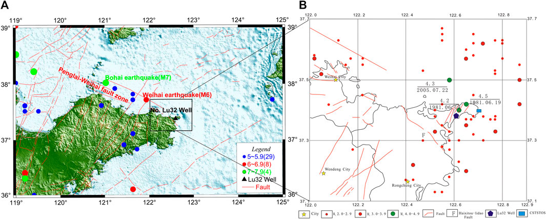
FIGURE 1. Seismotectonic settings of the No. Lu 32 well in the Jiaodong Peninsula, China. (A) Geological setting; (B) regional location [CSTSTOS is the Chengshantou seawater temperature observation station, and fault information and earthquake information are revised from (Chao et al., 1997)].
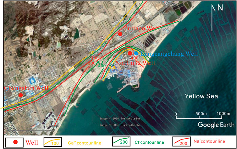
FIGURE 2. Location and distribution of the ion contours of the No. Lu 32 well and surrounding wells (sampling period: April 2017).
3 Data and methods
3.1 Hydrochemical characteristics and δD and δ18O stable isotopes
To analyze the genesis of water temperature variations, water samples from the No. Lu 32 well were collected from March 2016 to April 2018. Chemical ion concentrations and δD and δ18O stable isotope compositions in water samples were measured. To analyze the spatial distribution characteristics of water chemistry, the ion contents and hydrogen and oxygen isotope compositions of the Lengcangchang, Pujiapo, and Chengshan wells in the vicinity were collected and tested in April 2017 (Figure 2). The Lengcangchang well is located approximately 50 m from the No. Lu 32 well, the Pujiapo well is approximately 600 m from it, and the Chengshan well is approximately 3.5 km from the No. Lu 32 well (Figure 2). The ion concentrations and δD and δ18O stable isotope compositions were measured at the Key Laboratory of Crustal Dynamics, National Institute of Natural Hazards, Ministry of Emergency Management of China. Volumetric analysis methods and CIC-200 ion chromatograph were used for hydrochemistry analysis. δD and δ18O stable isotopes were measured using a type of LGR 912-0008 Hydrogen-Oxygen Stable Isotope Analyzer.
3.2 Water temperature for long-term observations
The No. Lu 32 well is 94 m deep, and the observed aquifer is fracture water in granite. Digital underground water temperature and water level observations have been implemented since September 2007. The No. Lu 32 well uses an SZW-1A digital thermometer for geothermal observation, with a probe depth of 89 m, and an LN-3A digital water level meter for digital water level observations was used in the well with a probe depth of 7.1 m.
4 Results
The hydrochemical characteristics and δD and δ18O stable isotope compositions are shown in Table 1. The ion contents and hydrogen and oxygen isotope compositions of the wells and seawater were collected in April 2017 and tested once, while the waters from No. Lu 32 well were collected five times from March 2016 to April 2018. It can be seen from Table 1 that the ion contents of seawater were higher than those of the wells.
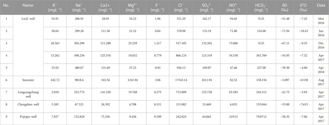
TABLE 1. Hydrochemical characteristics of the No. Lu 32 well and seawater in the Jiaodong Peninsula.
4.1 Chemical type of the No. Lu 32 well water
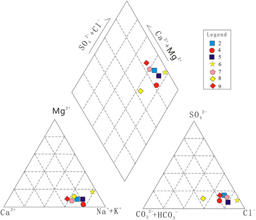
Piper diagrams were drawn according to the Ca2+, Mg2+, and Na+–K+ concentrations and relative Cl−, SO42−, and HCO3−contents (Figure 3), which can directly indicate the general chemical characteristics of the samples and water types. The intersection point obtained from the upper diamond represents the milliequivalent contents of anions and cations in the waters, the triangle in the lower left corner represents the milliequivalent contents of cations, and the triangle in the lower right corner represents the milliequivalent contents of anions. Figure 3 shows that the Na+, K+, and Cl− milliequivalent concentrations were relatively high, and the water chemistry type of the No. Lu 32 well was the Cl–Na type, indicating intermediate mineralization water of mixed origin and that the water may be related to seawater.
4.2 Water‒rock reaction processes
The Na–K–Mg ternary diagram is mainly used to analyze the water‒rock equilibrium state in groundwater (Su et al., 2021). According to the analysis of the Na–K–Mg ternary diagram, seawater is located near the mineral equilibrium line, and the Na–K–Mg water‒rock interaction reaches the ionic equilibrium state (Figure 4). In contrast, the data of the No. Lu 32 well and nearby wells were basically distributed near the Mg end, which indicated unsaturated water, the water‒rock interaction had not yet reached the ionic equilibrium state, and the water‒rock interaction was still ongoing, indicating that the No. Lu 32 well possessed the characteristics of shallow water (Figure 4).
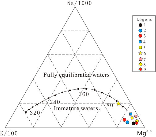
FIGURE 4. Na–K–Mg diagram of the No. Lu 32 well (the number in the figure corresponds to that in Table 1).
4.3 δD and δ18O stable isotope characteristics
The isotope analysis method has been widely used in environmental hydrogeological research. The analysis of hydrogen and oxygen isotopes is an effective method for constraining the origin of groundwater (Tiwari et al., 2020; Sasaki et al., 2021; Duan et al., 2022). The Global Meteoric Water Line is the red line in Figure 5 (Craig, 1961; Li et al., 2011). The hydrogen and oxygen stable isotopes of nine samples were distributed near this line, and it is inferred that the study well and adjacent wells were influenced by meteoric water.
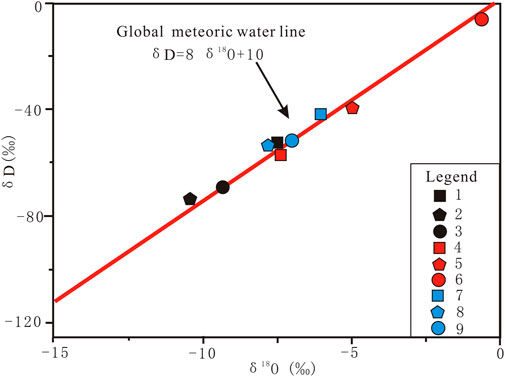
FIGURE 5. Relationships between the δD and δ18O values of the No. Lu 32 well and the Global Meteoric Water Line (GMWL) [the number in the figure corresponds to that in Table 2, and the GMWL is from (Craig, 1961)].
4.4 Annual variations in water temperature
The water temperature of the No. Lu 32 well has shown several fluctuations since January 2014, with a maximum variation of approximately 0.10°C.The water temperature exhibits a certain annual variation, and its variations from 2018 were used as an example. As shown in Figure 6, the water temperature in the observation well fluctuated several times between October and May of the following year, and the characteristics of the changes varied from year to year.
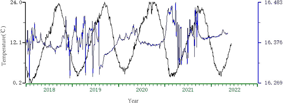
FIGURE 6. Comparison of temperature between CSTSTOS and the No. Lu 32 well from January 2018 to May 2022. The black line is the seawater temperature of CSTSTOS, and the blue line is the groundwater temperature of the No. Lu 32 well.
5 Discussion
Fluid geochemistry, such as the determination of hydrogeochemical characteristics and measurement of stable hydrogen and oxygen isotopes, is a promising and important method for determining the genesis of groundwater (Su et al., 2021; Du et al., 2023). Based on previous geological data of water chemistry and hydrogen‒oxygen isotope compositions, water chemistry data were first used to analyze the water type and water‒rock interactions of the No. Lu 32 well; the relationship between the No. Lu 32 well and meteoric water was then analyzed based on the hydrogen‒oxygen isotope compositions.
5.1 Spatial distribution of ion contents in the No. Lu 32 well and neighboring wells
Coastal zones are the most sensitive regions on Earth, and have multiple groundwater quality types, such as fresh, brackish, and saline water (Sun et al., 2023). The results of the water chemistry analysis in April 2017 showed the contours of Na+, Ca2+, and Cl− in the No. Lu 32, Chengshan, and Pujiapo wells (Figure 2). At the same time, with increasing distance from the sea, the ion content of seawater exhibited a decreasing trend from the No. Lu 32, Lengcangchang, and Chengshan wells to the Pujiapo well, suggesting that their sources may be seawater infiltration. This spatial distribution characteristic of the water chemistry compositions is consistent with previous research results in other coastal zones (Liu et al., 2017; Sun et al., 2023).
5.2 Seawater mixing effect
From the water chemistry data, we found that the No. Lu 32 well received a small amount of seawater recharge, and the mixing ratio of seawater was calculated using the water chemistry ratio method (Jaime, 1990; Wang, 2018) by the following equation:
where x is the proportion of groundwater in the mixing water, F is the content of a certain ion in groundwater, (1−x) is the proportion of seawater in the mixing water, S is the content of a certain ion in seawater, the ion content in seawater is referred to as the global average ion contents (Wang, 2018), and M is the content of a certain ion in the mixing water. The calculation results are shown in Table 2. The mixing ratio of the No. Lu 32 well was approximately 5%.
5.3 Annual variations between well and seawater temperatures
To analyze the possible effects of seawater temperature changes on groundwater temperature in the No. Lu 32 well, we collected the ocean forecast values of the surface water temperatures in the neighboring area, Port West, which is next to a farming area (Figure 2); the temperature comparison chart is shown in Figure 6.
There is a clear seasonal variation in the seawater temperature in the western Yellow Sea region (Hou et al., 2010), with an increasing trend in April and the highest annual surface water temperature from June to August; the highest values in 20 m and 30 m of seawater start in August–October (Quan et al., 2013), which is also similar to the time when the water temperature in the No. Lu 32 well exhibits an increasing trend (Figure 6). As the coastal area of the Jiaodong Peninsula has experienced severe seawater backflow in recent years, we cannot eliminate the possibility that seawater backflow and other factors influence the water temperature in the observation well.
5.4 Genetic model
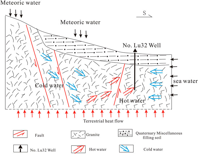
Through analyzing hydrochemical characteristics and hydrogen and oxygen isotope characteristics, combined with geochemical and geological survey results, the genesis of groundwater can be comprehensively inferred, providing a scientific basis for the analysis of water temperature change characteristics (Sui et al., 2020; Du et al., 2023). The Na+, K+, and Cl− concentrations were relatively high, which may be related to the influence of seawater, while the hydrogen and oxygen isotopes showed that meteoric water may be the source of the No. Lu 32 well. Based on the surrounding geological features, as well as the groundwater and seawater, the groundwater genetic model of the No. Lu 32 well was established (Figure 7). Figure 7 shows that the water level is influenced by meteoric water, while the water temperature changes produce a certain annual pattern of variation due to the influence of seawater. Our research conclusion is similar to the groundwater study in the adjacent area of the Huanghai Sea (Gao et al., 2016; Sun et al., 2023).
6 Conclusion
The water chemistry type of the No. Lu 32 well is Cl–Na, which indicates intermediate mineralization water with a mixed origin. The Na–K–Mg ternary diagram analysis reveals that the water is unsaturated, the water‒rock interaction state has not yet reached ionic equilibrium, and the water‒rock interaction is still ongoing, indicating that the No. Lu 32 well exhibits the characteristics of shallow water. The hydrogen and oxygen isotope distributions are near the meteoric water line, and it is presumed that the No. Lu 32 well and the neighboring wells are influenced by meteoric water. Since the water temperature of the No. Lu 32 well has some quasi-synchronous and morphological similarity with seawater temperature, the results of the water chemistry and isotope analysis of this well also indicate that the groundwater is influenced by seawater. A comprehensive analysis suggests that the No. Lu 32 well is affected by various factors, including seawater backflow infiltration and shallow water.
Data availability statement
The original contributions presented in the study are included in the article/Supplementary Material; further inquiries can be directed to the corresponding author.
Author contributions
GD: methodology, data curation, and writing—original draft preparation. SS: writing—review and editing. BZ: methodology, conceptualization, and writing—review and editing. LS: writing—review and editing. XC: writing—review. HR: methodology, data curation, and validation. MS: editing. LW: editing.
Funding
This study was financially supported by the Laoshan Laboratory (Nos LSKJ202203504 and LSKJ202204201), the Monitoring, Prediction and Research-combined Project of the China Earthquake Administration (No. SJH202302059), the National Key Research and Development Program of China (No. 2019YFC1509203), and the Marine Geological Survey Program of the China Geological Survey (DD20221707).
Acknowledgments
Some figures were made using the Generic Mapping Tools (https://forum.generic-mapping-tools.org/, last accessed March 2020) (Wessel et al., 2013).
Conflict of interest
Author LW was employed by CNPC East China Design Institute Co., Ltd.
The remaining authors declare that the research was conducted in the absence of any commercial or financial relationships that could be construed as a potential conflict of interest.
Publisher’s note
All claims expressed in this article are solely those of the authors and do not necessarily represent those of their affiliated organizations, or those of the publisher, the editors, and the reviewers. Any product that may be evaluated in this article, or claim that may be made by its manufacturer, is not guaranteed or endorsed by the publisher.
References
Chao, H., Wang, Q., and Li, J. (1997). Seismotectonic map of Shandong Province, new tectonic map of Shandong Province and instructions (China: S.M. Press), 100–132.
Craig, H. (1961). Isotopic variations in meteoric waters. Isotopic Var. Meteoric Waters Scinece 133, 1702–1703. doi:10.1126/science.133.3465.1702
Du, G., Su, S., Chang, X., Ren, H., Huo, Z., and Zhang, X. (2023). Hydrogeochemical characteristics and Genesis of Hongshuilantang Hot Spring and its water temperature anomalies during the Rushan earthquake swarm in Eastern China. Front. Earth Sci. 10, 1088240. doi:10.3389/feart.2022.1088240
Duan, R., Li, P. Y., Wang, L., He, X., and Zhang, L. (2022). Hydrochemical characteristics, hydrochemical processes and recharge sources of the geothermal systems in Lanzhou City, northwestern China. Urban Clim. 43, 101152–152. doi:10.1016/j.uclim.2022.101152
Gao, X., Liang, H., Wang, H., Zheng, L., Li, J., Zhao, C., et al. (2015). Origin of the mud volcano in northern Tianshan constrained by geochemical investigation. Seismol. Geol. 4 (37), 1215–1224. doi:10.3969/j.issn.0253-4967.2015.04.021
Gao, M., Hou, G., and Guo, F. (2016). Conceptual model of underground brine formation in the silty coast of laizhou bay, bohai sea, China. J. Coast. Res. 74, 157–165. doi:10.2112/si74-015.1
Gu, Q., Ding, Z., Kang, Q., and Li, D. (2020). Group velocity tomography of Rayleigh wave in the middle-southern segment of the Tan-Lu fault zone and adjacent regions using ambient seismic noise. Chin. J. Geophys. Chin. 63 (4), 1505–1522. doi:10.6038/cjg2020N0117
Hou, C., Guo, P., and Zhou, L. (2010). The mechanism analysis of water temperature difference between Shidao, Xiaomaidao,and Haiyang. Trans. Oceanol. Limnol. 2, 6–10. doi:10.13984/j.cnki.cn37-1141.2010.02.006
Jaime, J. (1990). Groundwater problems in coastal areas: E. Custodio (with the collaboration of G.A. Bruggeman and others) UNESCO, 1987, ISBN: 92-3-102415-9. Adv. Water Resour. 154. doi:10.1016/0309-1708(90)90010-2
Lai, G., Jiang, C., Han, L., Sheng, S., and Ma, Y. (2016). Co-seismic water level changes in response to multiple large earthquakes at the LGH well in Sichuan, China. Tectonophysics 679, 211–217. doi:10.1016/j.tecto.2016.04.047
Lai, G., Jiang, C., Wang, W., Han, L., and Deng, S. (2021). Correlation between the water temperature and water level data at the Lijiang well in Yunnan, China, and its implication for local earthquake prediction. Eur. Phys. J. Special Top. 230 (1), 275–285. doi:10.1140/epjst/e2020-000255-3
Li, Y., Zhang, M., Wang, S., Li, Z., and Wang, F. (2011). Progress of the research of stable isotope in precipitation in China:A review. J. Glaciol. Geocryol. 33 (3), 624–633.
Liu, Y., Ren, H., Zhang, L., Fu, H., Sun, X., He, D., et al. (2015). Undergrund fluied anomalies and the precursor mechanisms of the Ludian Ms6.5 earthquake. Seismol. Geol. 1 (337), 307–318. doi:10.3969/j.issn.0253-4967.2015.01.024
Liu, S., Tang, Z., Gao, M., and Hou, G. (2017). Evolutionary process of saline-water intrusion in holocene and late Pleistocene groundwater in southern laizhou bay. Sci. Total Environ. 607–608 (0048-9697), 586–599. doi:10.1016/j.scitotenv.2017.06.262
Ma, Y. (2016). Earthquake-related temperature changes in two neighboring hot springs at Xiangcheng, China. Geofluids 16 (3), 434–439. doi:10.1111/gfl.12161
Ma, Y., Huang, F., Xue, Y., and Wang, B. (2015). Statistical analysis of long-term observation data of water temperature in springs and wells. Technol. Earthq. Disaster Prev. 2 (10), 367–377. doi:10.11899/zzfy20150217
Miyakoshi, A., Taniguchi, M., Ide, K., Kagabu, M., Hosono, T., and Shimada, J. (2020). Identification of changes in subsurface temperature and groundwater flow after the 2016 Kumamoto earthquake using long-term well temperature–depth profiles. J. Hydrology 582, 124530. doi:10.1016/j.jhydrol.2019.124530
Pan, S., Wang, F., Zheng, Y., Duan, Y., Liu, L., Deng, X., et al. (2015). Crustal velocity structure beneath Jiaodong Peninsula and its tectonic implications. Chin. J. Geophys. 9, 3251–3263. doi:10.6038/cjg20150920
Pope, E., Bird, D., and Arnórsson, S. (2014). Stable isotopes of hydrothermal minerals as tracers for geothermal fluids in Iceland. Geothermics 49, 99–110. doi:10.1016/j.geothermics.2013.05.005
Qu, J., Gao, S., Wang, C., Liu, K., Zhou, S., Yang, Y., et al. (2021). Crustal P-wave velocity structure and earthquake distribution in the Jiaodong Peninsula, China. Tectonophysics 814, 228973. doi:10.1016/j.tecto.2021.228973
Quan, Q., Mao, X., Yang, X., Hu, Y., Zhang, H., and Jiang, W. (2013). Seasonal variations of several main water masses in the southern Yellow Sea and East China Sea in 2011. J. Ocean Univ. China 12 (4), 524–536. doi:10.1007/s11802-013-2198-5
Sasaki, K., Morita, J., Iwaki, C., and Ueda, A. (2021). Geochemical evaluation of geothermal resources in Toyama Prefecture, Japan, based on the chemical and isotopic characteristics of hot spring waters. Geothermics 93, 102071. doi:10.1016/j.geothermics.2021.102071
Song, D., Chen, Y., Wang, T., Li, M., and Li, P. (2021). Organic geochemical compositions of mesoproterozoic source rocks in the yanliao rift, northern China. Mar. Petroleum Geol. 123, 104740–104820. doi:10.1016/j.marpetgeo.2020.104740
Su, S., Chen, Q., Zou, C., Yan, B., Du, G., and Feng, E. (2021). Hydrogeochemical characteristics and Genesis of seismic observation wells in Shandong Province, China. Arabian J. Geosciences 14 (22), 2398. doi:10.1007/s12517-021-08774-w
Sui, L., Du, G., and Chen, Q. (2020). Formation mode of wenquantang hot spring in weihai city. Shandong Land Resour. 36, 40–45. doi:10.12128/j.issn.16726979.2020.10.007
Sun, Q., Gao, M., Wen, Z., Hou, G., Dang, X., Liu, S., et al. (2023). Hydrochemical evolution processes of multiple-water quality interfaces (fresh/saline water, saline water/brine) on muddy coast under pumping conditions. Sci. Total Environ. 857 (1), 159297. doi:10.1016/j.scitotenv.2022.159297
Tiwari, S., Gupta, A., and Asthana, A. (2020). Evaluating CO2 flux and recharge source in geothermal springs, garhwal himalaya, India: Stable isotope systematics and geochemical proxies. Environ. Sci. Pollut. Res. 27 (13), 14818–14835. doi:10.1007/s11356-020-07922-1
Wang, X. (2018). A study of the charateristics and genesis of the hot springs in the western Shandong Peninsula. Master. Beijing: China University of Geosciences.
Wang, Z., Deng, Q., Chao, H., Du, X., Shi, R., Sun, Z., et al. (2006). Shallow depth sonic reflection profiling studies on the active Penglai Weihai fault zone offshore of the northern Shandong peninsula. Chin. J. Geophys. 4 (49), 1092–1101. doi:10.1002/cjg2.920
Wessel, P., Smith, W., Scharroo, R., Luis, J., and Wobbe, F. (2013). Generic mapping tools: Improved version released. Eos,Transactions Am. Geophys. Union 45 (94), 409–410. doi:10.1002/2013eo450001
Zhang, L., Guo, L., Zhou, X., Yang, Y., Shi, D., and Liu, Y. (2021). Temporal variations in stable isotopes and synchronous earthquake-related changes in hot springs. J. Hydrology 599, 126316. doi:10.1016/j.jhydrol.2021.126316
Zhao, L., Xie, X., Wang, W., Zhang, J., and Yao, Z. (2010). SeismicLg-waveQtomography in and around northeast China. J. Geophys. Res. 115 (B8), B08307. doi:10.1029/2009jb007157
Keywords: No. Lu 32 well, hydrochemistry, genesis, seawater mixing, water temperature
Citation: Du G, Zhai B, Su S, Sui L, Chang X, Ren H, Sun M and Wang L (2023) Hydrogeochemical characteristics and the genesis of the No. Lu 32 well in the Jiaodong Peninsula, China. Front. Earth Sci. 11:1131539. doi: 10.3389/feart.2023.1131539
Received: 25 December 2022; Accepted: 08 February 2023;
Published: 23 February 2023.
Edited by:
Qingqiang Meng, SINOPEC Petroleum Exploration and Production Research Institute, ChinaReviewed by:
Haijian Lu, Chinese Academy of Geological Sciences (CAGS), ChinaShengfa Liu, Ministry of Natural Resources, China
Copyright © 2023 Du, Zhai, Su, Sui, Chang, Ren, Sun and Wang. This is an open-access article distributed under the terms of the Creative Commons Attribution License (CC BY). The use, distribution or reproduction in other forums is permitted, provided the original author(s) and the copyright owner(s) are credited and that the original publication in this journal is cited, in accordance with accepted academic practice. No use, distribution or reproduction is permitted which does not comply with these terms.
*Correspondence: Bin Zhai, emhhaTY4NkAxMjYuY29t
 Guilin Du1,2
 Bin Zhai
 Shujuan Su
 Xiangchun Chang