 Jerome G. Kimaro
 Valeska Scharsich3
 Christina Bogner
- 1Department of Soil Physics, University of Bayreuth, Bayreuth, Germany
- 2Directorate of research, Tanzania Wildlife Research Institute, Arusha, Tanzania
- 3Ecological Modeling, BayCEER, University of Bayreuth, Bayreuth, Germany
On the southern slopes of Mt.Kilimanjaro like in many other regions in East Africa, agriculture strongly depends on irrigation. Water is supplied to farms by an extensive network of open unlined canals, most of them built centuries ago. However, information about the distribution of these irrigation canals and the dynamics of their discharge is rare thus hampering the implementation of sustainable solutions for agricultural water management. We suppose that several factors like topography, soil properties, shifts of cropping patterns, and weak institutions affect availability and management of agricultural water. Therefore, in this study we determined (i) the distribution of irrigation canals, (ii) their discharge patterns, and (iii) constraints to their sustainable management. Mixed–method approach consisting of both quantitative and qualitative methodologies was used. The discharge of canals was measured at 11 locations along an altitudinal gradient and selected canals were mapped to understanding their distribution, physical characteristics, and potential risks that limits their optimal discharge. Terrain attributes were derived from the Advanced Space borne Thermal Emission and Reflection Radiometer (ASTER) Digital Elevation Model (DEM) and soil physical and hydraulic conductivity were measured to understand permeability and stability of the soil. Additionally, we conducted focus group discussions with participants from 15 villages and 10 key informants interviews. We found that during the dry season the discharge of canals was higher than in the short rainy season. The discharge of canals increased with decreasing elevation. The median daily discharges equaled 12.6, 9.5, and 7.0 l/s in the lower, mid and upper areas, respectively. Landscape in the central part of the study area was the steepest (slope > 60%) and the roughest (Topographic Ruggedness Index > 80 m).We attribute this to terrain heterogeneity across the landscape, thus community decisions about distribution and maintenance of canals could differ across different villages. Furthermore, current shifts of cropping patterns increased irrigation water demands. Both formal and informal water institutions were constrained with several challenges that affected overall management of canals and their sources. Findings of this study could contribute to various efforts dedicated to improve management of water resources around Mt. Kilimanjaro.
Introduction
Mountain ecosystems provide a range of supporting and provisioning ecosystem services including food production. Over one billion people live in mountains and many more depend on mountain resources and services (Körner et al., 2005). Thus, mountain ecosystems play an important role in sustaining human well-being. Food production strongly depends on availability of water. In East Africa, rainfall patterns exhibit a strong seasonality (Haile, 2005; Yang et al., 2015; Otte et al., 2017) and irrigation is essential for maintaining crop production during the dry season. Mt. Kilimanjaro is recognized as an important water tower in East Africa and is one of UNESCO's world heritage sites due to its high biodiversity (Hemp, 2006b). The mountain is an important contributor to the Pangani River, a major river in north-eastern Tanzania (Røhr, 2003).
Topography, soil properties and agricultural practices influence the supply and distribution of water in different ways. Runoff generation, for example, depends both on topography and soil moisture that is itself affected by soil physical and hydraulic properties (Beven et al., 1988). Changes in farming system like removal of indigenous trees and expansion of monoculture cropping can potentially decrease the water use efficiency within farms. Indeed, agroforestry practices could improve soil water storage (Kuyah et al., 2017; Udawatta et al., 2017). Additionally, annual high-value crops have been reported to replace perennial crops around Mt. Kilimanjaro (Maghimbi, 2007) leading to a larger irrigation demand (Turpie et al., 2005). The increased irrigation demand is likely to intensify competition for water among users and could fuel social conflicts, especially between upstream and downstream users (Wiesmann et al., 2000; Amede, 2015).
Improving the link between local communities and public institutions can improve water management. However, experience from different parts of the country indicates that participation of local communities is still unsatisfactory (Dungumaro and Madulu, 2003). Often, their experience and expertise is ignored by planners and managers which might negatively impact the management of water resources (Maganga, 1998, 2003). To promote participatory approaches in water management, donor communities have promoted the concept of integrated water resources management (IWRM) in developing countries (Mehta and Movik, 2014). In Tanzania, water user associations (WUA) have been created in Pangani and Rufiji River basins, for example, to improve equitable water accessibility among user groups. However, there are several socio-economic barriers that limit full implementation of WUA at the local level (Sokile et al., 2003; Komakech et al., 2011). Similar observations have been reported by Biswas (2008) who noted that traditional water management systems were still popular in developing countries despite a strong promotion of IWRM by international institutions.
Around the southern slopes of Mt. Kilimanjaro, the open unlined canals (Mfongo in the local Chagga dialect) have been used by Chagga people, an ethnic group of Bantu origin, for decades. Winter (1994), Tagseth (2008), and Nakawuka et al. (2017) reported several drivers that influenced the creation of canals around Mt. Kilimanjaro. Like other in other East African communities, canals were important for sustaining agriculture food production and for domestic uses (Dundas, 1924; Winter, 1994). Increased diversity of food and cash crops in traditional Chagga home gardens was influenced by the presence of canals. Chagga dominated the supply of finger millet (Eleusine coracana) in the ancient coastal caravan trade after expansion of irrigation canals around Mt. Kilimanjaro (Grove, 1993; Bender, 2008).
Nearly 80% of total discharge at Mt. Kilimanjaro is assumed to be consumed by smallholder farmers (Misana, 1991). However, information about the distribution of irrigation canals and the dynamics of their discharge is rare thus hampering the implementation of sustainable solutions for agricultural water management. We suppose that hydrological patterns and management of irrigation canals at the southern slopes of Mt. Kilimanjaro are influenced by the complex interactions of several factors like topography, soil properties, and shifts of cropping patterns and weak institutions responsible for water management. Therefore, the aim of this study is to determine (i) the distribution of irrigation canals, (ii) their discharge patterns, and (iii) constraints to their sustainable management. This information could contribute to improve the management of water resources at the southern slopes of Mt. Kilimanjaro.
Materials and Methods
Study Area
Mt. Kilimanjaro is located 300 km south of the equator in Tanzania, on the border to Kenya, between 2°45′ and 3°25′S and 37°00′ and 37°43′E. This study was conducted on the southern slopes of Mt. Kilimanjaro starting from the plains (colline zone, 900 m) up to the forest (submontane zone, 1,600 m) (Figure 1). Major land uses in this area are influenced by the altitudinal gradient. The lower area is dominated by maize monocropping and pastoralism (Soini, 2005; Misana et al., 2012). In the mid area (1,200–1,350 m) the dominant farming systems are coffee–banana agroforestry and increasingly also maize fields. Additionally, several coffee estates operate as large-scale farming in the study area. In the upper area (1,350–1,600 m), Chagga home gardens, a traditional form of agroforestry with banana and coffee as dominant crops, have been cultivated for centuries by local inhabitants (Fernandes et al., 1985).
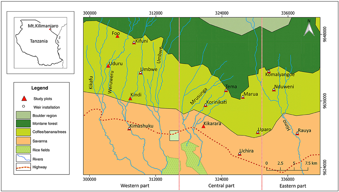
Figure 1. Study area (Google Maps 2017). We subdivided it into the western, central, and eastern parts to simplify the description of results.
Two distinct rainy seasons occur in the study area; the long rains start from mid-March and stop at the end of May while the short rains occur between October and December. Occasionally, short rains extend to end of January of the following year. The driest period is from July to end of September, while April and May are the wettest months. The mean annual rainfall increases from 600–900 mm in the lower area, to 1,000–1,200 mm in the mid area and 1,800–2,000 mm in the upper area, respectively (Hemp, 2005; Misana et al., 2012).
The soils at Mt. Kilimanjaro originate from volcanic material. Because their genesis is largely dominated by the altitudinal gradient, similar soils developed at similar altitudes. On the small and steep volcanic craters on the East of Mt. Kilimanjaro, the main soil type is Leptosol (IUSS Working Group WRB, 2015; Borrelli et al., 2017), whereas in the plains Acrisols, Ferralsols, Lixisols, Nitisols, and Vertisols dominate (Zech et al., 2014).
The open canals dug into the earth (Mfongo in Chagga dialect) are still the major infrastructure for conveying agricultural water through gravity to crop fields around Mt. Kilimanjaro. Canals obtain their water both from rivers and springs, most of them confined within the mountain forest belt. However, a number of springs are found around the upper cultivated areas. In addition to canals, the Chagga irrigation systemis composed of small earth dams, 30–50 m2 in size, locally known as Nduwas (Figure S1). Chaggas used Nduwas to sustain irrigation during the dry season or where the sources have a low discharge capacity. Because most Nduwas are situated inside the national park with restricted access, they are not well managed (Pers.comm.). When a canal is not used for irrigation, especially during the rainy season or night, water is drained to the river through a secondary canal at the end of the scheme.
Mapping of the Canals Network
The canal network extends over a vast area with variable geomorphologic attributes and land uses (O'Kting'ati, 1991; Devenne, 2006; Misana et al., 2012). For comparison purpose, the study area was subdivided into three sub-regions across the slope, namely: western, central, and eastern parts, respectively. In the western part of the study area, mapping covered Kifuni, Uduru, and Kimashuku villages. Additionally, we mapped canals located in Tema, Korinikati, and Kikarara villages around the central part. Villagers familiar with the management of canals in their villages helped to locate the canals, identify their names, sources, and locations.
We used a GPS device (Garmin GPSMAP 64s) to mark the course and intake points of primary canals. Additionally, we measured physical features like width, depth, length, and intersection angles using a ruler and an angle protractor. Depth and width of canals were measured at several points (N = 50) for each surveyed canal. Notably, mapping of secondary and tertiary canals was not possible because they were too numerous. However, we established a hand-drawn sketch map as an expression of the actual layout we observed in the field.
Additionally to canals, we also assessed the structure and functions of earth dug reservoirs which are an important part of the Chagga irrigation system. We measured their physical features like width, depth, and length. Besides that, traditional techniques employed in their construction and maintenance were assessed. Further to this, we evaluated the major risk factors related to damage of canals infrastructure and water losses during conveyance. Finally, recorded coordinates were imported into a GIS environment to produce a distribution map of canals. QGIS inbuilt tools were used to compute spatial features like canal length and distances between canals. The same software was used to produce canals distribution maps.
Terrain Analysis
Topography influences hydrological processes and affects stream network, soil moisture, and ground water flow (Beven et al., 1988). Therefore, topographical indices can be used to understand the distribution of canals and their discharge patterns. The Advanced Space borne Thermal Emission and Reflection Radiometer (ASTER) Digital Elevation Map (DEM) with the 30 m resolution was downloaded from the Earth Explorer, USGS website (https://earthexplorer.usgs.gov). QGIS version 2.14 and GRASS version 7.0 were used for subsequent GIS analyses. Prior to the analysis, surface depressions of the DEM were filled (Wang and Liu, 2006). For the terrain analysis we used r.watershed and r.slope.aspect modules from the GRASS GIS tool kit for Hortonian analysis (Martz and Garbrecht, 1993; Jasiewicz and Metz, 2011). The module r.watershed was used to compute Topographic Wetness Index (TWI) and the drainage direction (Dd) based on single direction D8 flow model (O'Callaghan and Mark, 1984). Furthermore, QGIS raster terrain analysis plugin was used to compute terrain slope and Ruggedness Index (TRI).
The TWI (Beven and Kirkby, 1979) indicates the relative soil moisture at a point and shows where the flow accumulates:
where α is the upstream contributing area, and β the slope, respectively.
The TRI describes topographic heterogeneity (Riley, 1999) and is calculated as follows:
where (x00) is the elevation of a pixel in the DEM and (xij) are elevations of its eight adjacent neighbor pixels.
Soil Physical and Hydraulic Properties
To understand the susceptibility of the unlined canals to percolation losses, we measured the saturated soil hydraulic conductivity (Ksat). Wachyan and Rushton (1987) and Jadczyszyn and Niedz'wiecki (2005) reported that values of saturated soil hydraulic conductivity can be used to predict soil and water loss under different land management practices and climatic conditions. In lower areas measurements were conducted in Kimashuku, Kikarara, Uchira, and Rauya, while mid areas involved Uduru, Korinikati, Uparoand Nduweni villages and upper areas Foo, Tema, Komalyangoe, and Marua (Figure 1). In each village, we established four subplots in a 1 ha plot based on the Land Degradation Surveillance Framework (LDSF) (Vagen et al., 2010). Because the canals are unlined and shallow (15–30 cm) and frequently scrapped during cleaning, we assumed that their permeability was similar to the soil on adjacent farms. We measured Ksat with a double ring infiltrometer (Köhne et al., 2011). Soil samples for texture analysis were collected from the same subplots. Bulk soil samples were collected from a depth of 30 cm. Samples were air dried and sieved <2 mm. Organic matter was removed by hydrogen peroxide in the hot bath. Wet sieving using a series of sieves was used to obtain sand classes and the fine particle suspension (Carter, 1993). Finally, the proportions of clay, silt, and fine sand were determined by automated sedimentation analysis using a PARIO equipment (METER Environment Ltd, USA) (Durner et al., 2017).
Discharge Measurements
To determine the discharge of canals, a network of 11 60° V-notch weirs was established at selected locations. We used the concept of citizens' science (Brossard et al., 2005) and developed a protocol in which 11 villagers were trained to read the weirs, monitor, and report various causes of discharge fluctuations in canals. Discharge was recorded three times a day (morning, afternoon, and evening) from June 2015 to February 2016, after the end of the long rainy season (from March to June). Most inflows of canals were either closed or the flow rate was reduced during the long rainy season because the irrigation demand decreases. Closing canals reduces the flooding risk caused by canal overflow. Furrow discharge was computed by Kindsvater-Shen equation (Shen, 1981).
where C is the discharge coefficient, h the height of water in the canal, k the head correction factor and the notch angle, respectively. To determine the current status of canals, we asked members of village water committees to conduct a survey in their respective villages and to report on (i) the total number of present canals, (ii) their flow status (dried, perennial, or seasonal), and (iii) their major sources.
Collecting Social Economic Data Through Interviews
We organized Focus Group Discussions (FGDs) and key informants (KI) interviews to collect socioeconomic information. The former involved 15 discussion meetings in villages where study plots were located (Figure 1). Between 10 and 15 villagers attended each meeting. The meetings involved diverse social groups of villagers like women, elderly people, and leaders in order to obtain a good representation of their communities (Kitzinger, 1994). Before starting each meeting, the informed-consent procedure was followed to ensure the participants about the confidentiality of their identities and their contributions (Krueger and Casey, 2014).
Two major participatory approaches were used. Firstly, the open-ended protocol was used to guide discussions and secondly, villagers formed discussion groups for brainstorming on different topics provided (Krueger and Casey, 2014). The following questions led the discussions: (i) Distribution of canals and their sources on mountain slope, (ii) Procedures used in water sharing among key water users, (iii) Major constraints to daily maintenance of canals and their sources, (iv) Agricultural water management under different farming systems, (v) Recent changes in cropping systems and agronomic practices, (vi) Major causes of water losses during water conveyance in canals, and (vii) Local perceptions about use of canals among Chagga people. The abbreviation “Pers. comm,” meaning personal communication, will be used in this paper to report content discussed during FGDs and KIs meetings.
Interviews with KI (10 interviews) involved the officials from Hai and Moshi Rural district councils, water experts from Pangani Basin Water Office (PWBO) in Moshi and officials from Northern Zone Irrigation Office. Our discussions broadly focused on institutional matters related to management of agricultural water, implications of changing farming systems and disturbances around Mt. Kilimanjaro. The following were the major discussion questions: (i) Status of social linkages between traditional and formal institutions involved in water management, (ii) Major anthropogenic disturbances threatening discharge of canals and their sources, (iii) Compliance of national policies to sustainability of traditional canals, (iv) Strategies to reduce water losses in canals and social conflicts among different user groups.
Data Analysis
To analyse the information provided by village water committee members, FGDs and KIs several participatory approaches were used. Both qualitative and quantitative methods were used to generate contextualized data that can be counted, ranked, and compared (Ager et al., 2011). Farmers' observations regarding fluctuations of discharge in canals were grouped according to major causes, namely, normal flow (NRM), irrigation schedule (IS), repair and maintenance (RM), uncleaned canals (UC), dried canal (DC), and other (OT), if farmers were uncertain about the actual cause of fluctuation. Findings from village committees about the status of irrigation canals within their villages were grouped into three classes based on annual flow regime patterns, namely perennial, seasonal, and dried. The total number of canals in each village was calculated. Quantitative variables were analyzed in R (R Core Team, 2018). To generate descriptive statistics like frequency distribution (in percentage). Qualitative information from interviews was extracted by content analysis in order to categorize verbal data for classification and summarization (Hennink, 2013). All communication and discussion were in Kiswahili and translated in English later.
The discharge measurements are time series and their temporal autocorrelation must be accounted for in a model. Thus, we used a Generalized Additive Model (GAM) that can handle time series (Hastie and Tibshirani, 1990). A GAM is a non-linear additive model that allows for classical fixed effects (as in an ANOVA) and can also describe the relationship between a predictor and the response variable as a smooth function. We fitted different smoothing functions of time per elevation. They represent a general temporal dynamic of the discharge. Furthermore, we included a random effect of village (i.e., a random difference of mean discharge between villages). Additionally, we assumed that discharge is a function of elevation and farmers' observations regarding fluctuations of discharge. The latter factor means that canal management has an influence on discharge. Both, elevation and responses were included as fixed factors in the model:
where y is the discharge, s(time) the smooth term of time, βE, βFO are the fixed effects of elevation and farmers' observations [normal flow (NRM), irrigation schedule (IS), repair and maintenance (RM), uncleaned canals (UC), dried canal (DC), and other (OT)], bv is the random effect of the village and ε the error term, respectively. Observations with the status DC were excluded from the model. All calculations were done in R (R Core Team, 2018).
Results
Distribution of Canals
According to responses from FGDs and field measurements, canal metrics like length, geographical orientation, and physical locations of their intakes and routes indicate remarkable differences. Indeed, canals in lower areas were wider (median: 45 cm) compared to those in upper areas (median: 20 cm). Canals around the central part were longer compared to those around the eastern part. For example, Machombo and Mzuki canals were more than 7 km long within the cultivation area. However, we could not establish their actual lengths since their sources are located inside the forest (above 2,000 m). By contrast, canals around the western part were not longer than 1.2 km. However, some canals were combined in order to extend their length. For example, the combination of Mrema (1.14 km) and Mwaana canals (1.3 km) around 1,300 m, could be extended 2.5 km further down slope, around 1,200 m (Figure 3). Additionally, several secondary and tertiary canals were branched from primary canals at an angle between 30 and 90 degrees to convey water to irrigation schemes and individual plots (Figure S2).
Since there are numerous canals (Figure 2) around Mt. Kilimanjaro, it was not possible to determine their total number, their drainage status and their physical features in each irrigation schemes. However, responses from FGDs and water experts from PWBO indicated that the canal network around the upper western and eastern parts could be denser than in the central part. However, because irrigation is increasing at lower slopes, there could be more tertiary canals compared to upper slopes. Nearly each farm plot was crossed by a tertiary canal conveying water to adjacent plots. KIs reported that between 1,000 and 2,000 primary irrigation canals were estimated to exist around the southern slopes of Mt. Kilimanjaro.
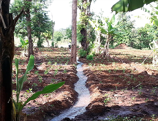
Figure 2. Traditional irrigation canals around Mt. Kilimanjaro.
On the other hand, mountain geomorphology has an influence on routing and orientation of canals (Figure 3). Since Chagga canals are gravity controlled, their flow is determined by landscape topography. The analysis of the drainage direction of the study area indicated different flow directions which could also influence canal routing (Figure S3). Canals originating from western and eastern upper areas were flowing toward the south-east, while those from the central part were oriented toward south-west. Additionally, the landscape around the central part was rougher. The median TRI values equaled 6.31, 4.5, and 2.8 m for the central, western, and eastern parts, respectively (Figure 4).
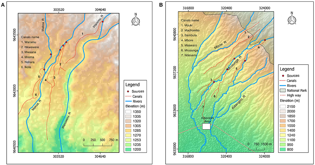
Figure 3. Distribution of canals around Uduru Village, western side of Mt. Kilimanjaro (A) and around central area of Mt. Kilimanjaro (B).
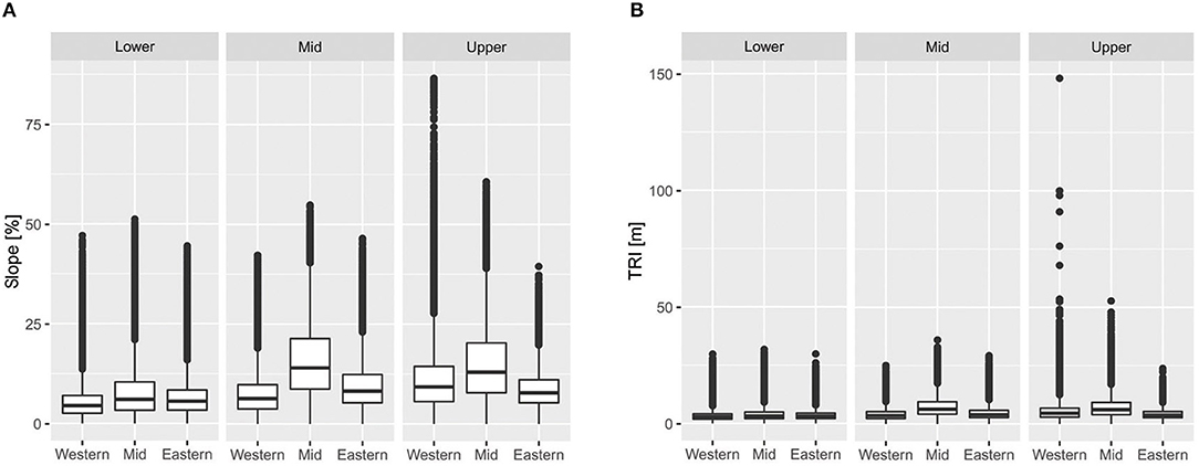
Figure 4. The variation of terrain slope around the southern slopes (A) and TRI of Mt. Kilimanjaro (B).
Accordingly, steeper slopes (median >15%) were determined on farms around the central part compared to those in the western and eastern parts (median <10%) (Figure 4). We observed a remarkable number of farms with slopes larger than 50% around Kidia and Mbokomu wards in the central part. However, a few cases of extreme steepness (slope > 60%) were found on the upper slopes of the western part, like in Foo and Nkwarungo villages.
The TWI around the lower areas was slightly higher (median > 6 m) compared to mid and upper slopes (median < 6 m). The combined effect of high TWI and low slope could provide favorable conditions for gravity based type of irrigation, like Chagga traditional canals. Although Chagga farmers cannot quantify water needs for different crops, a number of traditional techniques have already been developed. For example, farmers use a hand hoe to control water accumulation around crops' shoot during irrigation, old banana stems, or stones to regulate the speed of water within canals or diverting excessive canal flow back to the river.
Physical and Hydraulic Soil Properties
The particle size distribution (soil texture) varied along the elevation (Table 1). Generally, the content of sand and organic matter increased while the content of clay decreased with increasing elevation. The soil texture also varied between villages in the same elevation zone. For example, the largest proportion of sand (48–66%) was measured in Foo compared to Tema (24–29%). Accordingly, soil hydraulic conductivity Ksat increased with increasing elevation as the soils became more sandy from 1.1 to 4.9 cm/h (Figure 5).
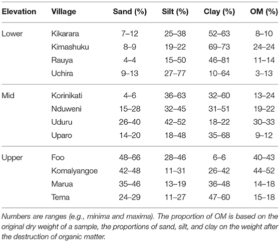
Table 1. Particle size distribution of the soil fine fraction and the percentage of soil organic matter (OM).
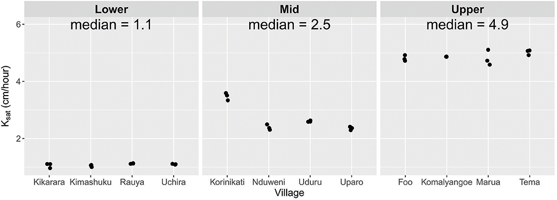
Figure 5. Spatial distribution of hydraulic conductivity around southern slopes of Mt. Kilimanjaro.
Discharge Patterns of Canals
The discharge of canals increased with decreasing elevation (Figure 6). The median daily discharges equaled 12.6, 9.5, and 7.0 l/s in the lower, mid, and upper areas, respectively. It also varied across villages in the same elevation zone. For example, in the lower area, canals in Uchira were dry during the whole observation period, while those in Kimashuku and Rauya conducted water. Similarly, in the upper area, the value of median discharge in Kifuni was nearly 50% larger than in Tema. The participants of FGDs and KI informants reported that most canals around Mt. Kilimanjaro were not lined. Given that soil permeability is heterogeneous (Figure 5), percolation losses probably vary across the landscape.
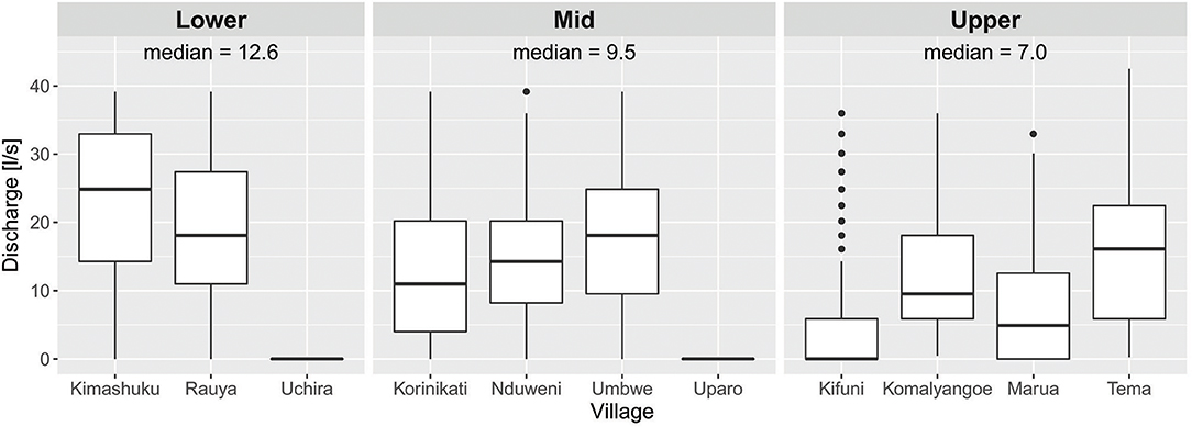
Figure 6. Spatial variability of discharge in irrigation canals along the three elevation zones.
We recorded higher discharge during the dry (July to end of October) compared to the short rainy season (November to end of January) (Figure 7). The irrigation demand decreases during the rainy season and the flow is reduced to prevent flooding. However, a certain minimum level of discharge is maintained during the rainy season to serve water for domestic use and livestock (Pers. comm).
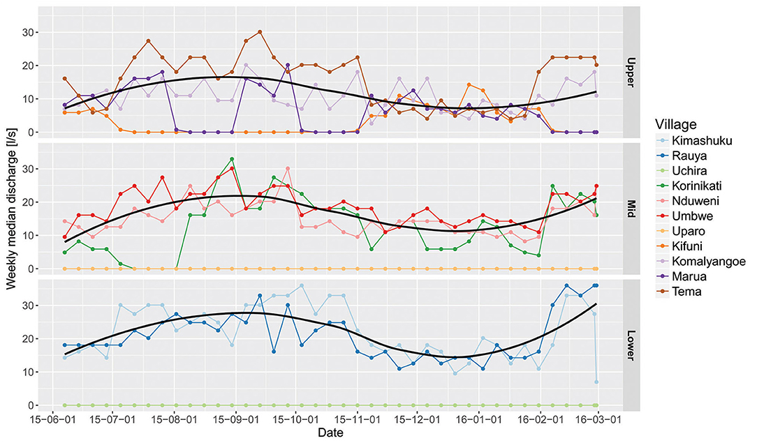
Figure 7. Dynamics of weekly discharge in irrigation canals along the three elevation zones. Black lines are produced by a less smoother for visualization only. Discharge with the state DC (dry canal) was excluded from smoothing.
The modeling results are summarized in Table 2, additional information on the distribution of residuals and significance of smooth and random terms can be found in the online Supplementary Material (Figures S4–S6 and Table S1). The parameter βE: Lower is the discharge in the lower area when farmers reported normal flow (NRM) and all other factors are additive to this model intercept. The discharge decreases significantly with increasing elevation. However, the difference between the mid and the upper areas is not significant (Wald test, p = 0.228). Irrigation schedule (IS) and repair and maintenance (RM) decrease the discharge significantly as do uncleanded canals (UC) and other causes not specified by the farmers (OT). Interestingly, uncleaned canals and irrigation reduced the discharge by roughly the same amount.
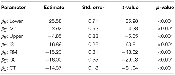
Table 2. Summary of the modeling results for the fixed and the interaction effects.
Canal Management
Water governance around Mt. Kilimanjaro is under both traditional and formal institutions. The former involve village or community water committees, while the later consists of Hai and Rural Moshi District authorities. KIs responses from both district indicated some common perceptions related to challenges of canal water management. The lack of sufficient funds was reported to limit several daily operations, like hiring more technical staff and paying for field transport. Land degradation was reported as the major environmental problem around Mt. Kilimanjaro. Several traditional techniques for land management, like long fallows, terraces, and mulching are familiar to Chaggas. Nonetheless, they are less practiced nowadays. Additionally, prohibited activities like cultivation or logging around water sources were reported to increase, thus water managers fear about decreasing discharge of rivers and springs in the future.
Generally, authorities recognized the importance of canal irrigation to livelihood of mountain communities. However, they are also concerned with non-agricultural user communities. Expansion of gravity pipe water was mentioned as a priority. Enabling rural and peri-urban households to access clean domestic water is a national call. It was further mentioned that the national water policy emphasized on promotion of medium to large scale irrigation schemes. Concurrently, no clear guidelines have been developed for improving traditional schemes. Despite that, pumping water from rivers for irrigation around Mt. Kilimanjaro has been strictly banned by district authorities. At the community level, the authority of traditional leaders has declined hence fail to mobilize the voluntary force deployed for regular canal maintenance. Additionally, the trend of rural-urban migration among youths was reported to rise, leading to an increased proportion of elderly and children in the community who cannot undertake canal works. From FGDs meeting, we learnt that canal discharge has been decreasing over time based on responses (80%) of elderly participants whose age was above 50 years. However, the overall perceptions of canal management differed from one village to another. Seventy percent of respondents from lower central part complained about lacking access to irrigation during the dry season. This was due to drying of canals before reaching lower areas. Likewise, nearly 100% of participants from Uparo and Uchira villages had a concern about the complete drying of their canals. Most villagers (68%) from upper areas were less concerned about scarcity of irrigation water. There is less irrigation around many villages in upper areas. However, an exception was noted in Kifuni and Marua villages where 75% of participants were concerned about intermittent discharge of their canals. Notably, a substantial number of farmers from these villages was reported to grow hybrid coffee varieties that are less drought tolerant. Additionally, canals and their sources were used for different cultural purpose by Chagga. This includes ritual practices and paying tributes to ancestors who built them. We noted that most primary canals carried a name of their founder.
Farmers' commitment to canal management around Mt. Kilimanjaro is highly variable (Figure 8). Canals around the lower areas were better maintained. Indeed, farmers reported that canals in the upper areas were not regularly cleaned (UC) and the structures were not repaired frequently (RM). Consequently, a number of canals like Kifuni and Marua failed to maintain their discharge (DC) throughout the year. Notably, their case was different to that of Uparo and Uchira canals which were affected by over-abstraction of their sources (Pers. comm). Additionally, different other factors (OT), like trampling over canal wall by humans or animals, water theft or canal blockage by fallen tree were reported to affected canal discharge, especially around upper areas.
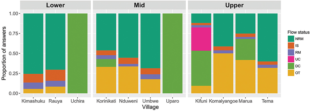
Figure 8. Farmers' observations on fluctuations of discharge in canals along the three elevation zones.
The assessment of the current status of irrigation canals from the selected 10 villages indicated that most of currently operating irrigation canals were perennial (47.7%) followed by seasonal (36.9%) while the least was dried canals (21.5%). It was difficult to quantify the status of reservoirs (Nduwas) since most of them were inside the national park. Contrary to institutional matters, environmental factors also affected canal conveyance. Perforations of canal banks by stream crabs were common in the upper areas. Other biological activities along canals were rodents and termites channels. Furthermore, canals were susceptible to erosion especially around the central area where canals run along steep slopes. When it rains, most canals were covered with transported sediments from upper slopes. Additionally, a few incidences of landslips were observed within the canal network. Sections of canals have been lost leading to discontinuous flow.
Discussion
Distribution of Canals
The use of simple motorized pumps could overcome terrain challenges. However, this is not an option around Mt. Kilimanjaro due to government restrictions on pumping water from rivers. Because the traditional irrigation system around Mt. Kilimanjaro is driven by gravity, routing, and length of canals could be more influenced by the topography rather than farmers' preferences. This accords with Horton (1945) and Beven et al. (1988) who noted that landscape morphology affected the routing of the surface run-off through channels.
Among the three sub-regions of Mt. Kilimanjaro, the distribution of irrigation canals could be less dense around the central part where crop fields are found on hills, in valleys, or along steep slopes. This topography limits the development of secondary canals toward locations where the terrain is not appropriate for gravity flow. Therefore, a considerable number of farm households could be confronted with both physical and economic water scarcity. Farmers on hills could be relying more on rain-fed agriculture. A previous study by Tagseth (2008) observed that rivers were already in deep gorges when crossing villages around Mbokomu in the central part. Similarly, Devenne (2006) noted that many canals in the central part run a long distance from their sources before reaching villages. During our field visit, villagers from the lower central part (Kiboriloni and Kikarara) complained about shortage of irrigation water during the dry seasons. Therefore, the emphasis should be given to improving the traditional water harvesting techniques (Nduwas) which could solve water supply challenges in many villages where small streams are not used for irrigation because of their lower discharge rates. Nduwas have been an integral part of the irrigation systems around Mt. Kilimanjaro for decades.
By contrast, farmers around the western and eastern parts could easily access irrigation water. Lower terrain ruggedness is favorable to the establishment of canal intakes at multiple points along the river. An extensive irrigation network around Uduru and Kimashuku villages have favored a successful horticultural production on the lower areas of Machame ward.
Chagga customary systems have a direct link to the distribution of canals around Mt. Kilimanjaro, thus reorganizing their layout in order to improve water distribution could be difficult. A strong connection exists between water, spiritual beliefs, and fortunes. For example, irrigation has been associated with successful settling of first Chaggas on the slopes of Mt. Kilimanjaro (Grove, 1993; Winter, 1994). Furthermore, canals have been used for political re-establishment and gaining social status among local leaders (Homewood, 2006; Bender, 2008). Our findings are in agreement with other studies done in Africa whereby culture, rituals, and beliefs have been connected to utilization of natural resources (Boaten, 1998). Thus, Chaggas' decision to maintain locations and names of their canals could be done deliberately for cultural reasons. Most canals were established before the Iron Age (Dundas, 1924), the pre-enlightenment era when working tools and state of technology were still underdeveloped in most parts of Africa.
Discharge of Irrigation Canals
Chagga irrigation canals are very sensitive to a range of natural and human-induced factors which affect the overall distribution of agricultural water. For example, steeper areas increased the water velocity in canals while in lower areas water accumulates due to a higher TWI value (Beven et al., 1988). Likewise, Strahler (1957) noted that landscape morphology influenced stream hydrographs, thus inducing spatial heterogeneity of catchment drainage. Given that most irrigation canals around Mt. Kilimanjaro are unlined, considerable amount of water could be lost en route through percolation and evaporation. Additionally, raised earthen canal banks could allow lateral seepage especially when canal flow is above ground level. Comparable studies have reported this weakness of traditional irrigation canals. An assessment by the FAO indicated a huge difference in field application efficiency between unlined earthen canals (60%) compared to concrete lined canals (90%) (Brouwer et al., 1989). Likewise, Turpie et al. (2005), reported that irrigation canals around Mt. Kilimanjaro had a low efficiency ranging between 15 and 50%. We attribute this to a high heterogeneity of soil hydraulic properties along the mountain elevation gradient and across the same slope.
Maintaining steady flow in traditional canals could be a challenging task for both farmers and water managers, in particular in areas with permeable soils. For example, high values of soil hydraulic conductivity and large proportion of sand in soils at the upper areas could lead to higher infiltration rates compared to lower areas. Water losses in canals have been reported as one of the major limitations to effectiveness of community-driven small holder traditional irrigation schemes in East Africa (Aberra, 2004; Ngigi et al., 2005; Makurira et al., 2007).
In contrast to traditional canals, establishment of modern canals consider several pre-requisites that improves water use efficiency. These include the discharge capacity of the sources, topography, number of users, soil properties, type of crops grown, and climate (Bos and Nugteren, 1990). Additionally, the control of canal flow can be easily manipulated within modern canals even where terrain slope could limit desirable discharge rates for irrigation (Clemmens and Replogle, 1980).
Furthermore, we relate canal discharge patterns to agricultural water demands around Mt. Kilimanjaro. Along the slope, zonation of farming systems is very clear (Fernandes et al., 1985). Although maize monocropping is still dominant at lower areas (Misana et al., 2012), rice irrigation schemes at Lower Moshi, Mabogini, and Njoro depend on mountain discharge (Ikegami, 1994). In upper areas, home gardens are still dominant and demand less irrigation. Agroforestry practice is known to improve soil water storage compared to annual crops monocropping (Kuyah et al., 2017; Udawatta et al., 2017). The exception is noted where vegetables are currently grown. Conversion of home gardens to vegetable and maize farming is increasing in upper areas of Mt. Kilimanjaro (Maghimbi, 2007; Misana et al., 2012).
Furthermore, the spatial variability of discharge could be related to current shifts of cropping patterns. According to the agricultural officer from Hai district (Pers. com), farmers increasingly prefer some new crop types, in particular vegetables and hybrid maize due to their high market demands. Concurrently, several traditional crops were widely abandoned. The most affected ones include Elfairia pedata and Dioscoreaceae family. Agronomically, new crop varieties demands more irrigation water compared to traditional ones. This may influence irrigation schedules and the amount of irrigation water needed by some farmers.
Management Challenges of Traditional Canals
Both formal and informal water institutions influence the current water management around Mt. Kilimanjaro. At the community level, declining authority of village water committees has been observed for decades. In the early 1960s, the government abolished all traditional rule systems in Tanzania and centralized the management of natural resources under the state (Kangalawe et al., 2014). Therefore, most of Chagga customary laws that enforce participation in canal works and protection of catchment resources became less respected by community members. On the other hand, the overall water management around Mt. Kilimanjaro indicates a top-down approach. According to Cleaver and Toner (2006) and Tagseth (2008), equality balance is lacking between local community and state agencies on decision making and representation in water projects development. Local communities have accumulated experience about hydrological behavior of the catchment. Thus, integrating their local expertise could help to avoid unforeseen negative consequences of water projects at local level. Decisions made by one side could be a contravention to other priorities and hence raise conflicts. Increased installation of gravity pipe projects around Mt. Kilimanjaro is an example. Establishment of Kirua-Kahe gravity water pipe has affected drainage of all irrigation canals that supplied water to Uparo. Comparable findings have been reported in Pangani (Komakech et al., 2011) and Rufiji River basins (Sokile et al., 2003).
The state mechanism for catchment protection is already established around Mt. Kilimanjaro (Kangalawe et al., 2014), however, cutting of trees can be easily spotted both in the national park and in home gardens. Apparently, local people also fail to recognize the importance of maintaining trees around water sources. The forest belt contributes the largest proportion of mountain discharge (Røhr and Killingtveit, 2003; Hemp, 2006a), and the vegetation in the mountain forest plays an important role in mountain hydrology (Po'cs, 1991; Schrumpf et al., 2011). Other ongoing disturbances around water sources include occasional wild fire and grazing (Lambrechts et al., 2002).
Conclusion
Gravity based irrigation canals are still the major means of supplying agricultural water around Mt. Kilimanjaro. Among the three sub-regions of the mountain slope, villages within the central part face more challenges to access canal water compared to those in the eastern and western parts. This was due to complex terrain in the central part which limits the expansion of primary canals. Similarly, spatial variation of canal discharge was observed along the elevation gradient. Indeed, topographical factors and soil properties influenced the dynamics of canal discharge. However, management of agricultural water also has a significant impact on canal water supply. Because an alternative supply of irrigation water is lacking, rising water demand increases the pressure on available sources.
The supply of irrigation water around Mt. Kilimanjaro can be improved without increasing abstraction rates from sources. Regular repair and maintenance of canals, especially around upper areas could improve conveyance efficiency and minimize water competition. Indeed, establishing lined canals could be too expensive for Chagga people. However, improvements can be prioritized where excessive leakages and physical damages are frequent. Several techniques for soil and water conservation (SWC) have been used by Chagga for decades. This includes application of mulching, planting indigenous trees, establishing contour grass strips and terraces. Additionally, traditional water harvesting techniques, like Nduwas could be promoted where small streams are not used because of their low discharge.
Considering the socio-economic importance of water to mountain and downstream communities, efforts to improve canals' water supply and the discharge capacity of their sources is inevitable. Furthermore, research is needed to investigate what prevent Chagga people from maintaining traditional techniques for conservation of agricultural water. The study findings from Mt. Kilimanjaro could be applied to other agro-ecosystems in Tanzania since large proportion of irrigation schemes are still traditional and rely heavily on surface water sources.
Data Availability
The datasets generated from this study is publicly available through the GFBio [https://www.gfbio.org/].
Author Contributions
JK, BH, and CB designed the study. JK and AK collected the data. JK, VS, and CB analyzed the data. JK and CB wrote the first draft. All authors discussed the results and the final version of the manuscript.
Funding
This study was supported by the German Research Foundation (DFG), grant numbers HU 636/16-2, BO4134/1-2, BO 4134/2-3 and the University of Bayreuth in the funding programme Open Access Publishing. This research is part of the research group FOR 1246: Kilimanjaro ecosystems under global change: Linking biodiversity, biotic interactions, and biogeochemical ecosystem processes.
Conflict of Interest Statement
The authors declare that the research was conducted in the absence of any commercial or financial relationships that could be construed as a potential conflict of interest.
Acknowledgments
The authors thank the villagers around Mt. Kilimanjaro, who participated in group discussions or offered their farms for field experiments. The assistance of officials from Hai and Moshi Rural District Councils, Northern Zone Irrigation Office, and PBWO to obtain several technical information related to canals hydrology and farming practices around Mt. Kilimanjaro is greatly acknowledged. This publication was funded by the German Research Foundation (DFG) and the University of Bayreuth in the funding programme Open Access Publishing.
Supplementary Material
The Supplementary Material for this article can be found online at: https://www.frontiersin.org/articles/10.3389/fenvs.2019.00024/full#supplementary-material
References
Aberra, Y. (2004). Problems of the solution: intervention into small-scale irrigation for drought proofing in the Mekele Plateau of northern Ethiopia. Geogr J. 170, 226–237.
Ager, A., Stark, L., Sparling, T., and Ager, W. (2011). Rapid appraisal in humanitarian emergencies using participatory ranking methodology (PRM). New York, NY: Program on Forced Migration and Health; Columbia University Mailman School of Public Health.
Amede, T. (2015). Technical and institutional attributes constraining the performance of small-scale irrigation in Ethiopia. Water Resour. Rural Dev. 6, 78–91. doi: 10.1016/j.wrr.2014.10.005
Bender, M. V. (2008). ‘For more and better water, choose pipes' building water and the nation on Kilimanjaro, 1961–1985. J. South. Afr. Stud. 34, 841–859. doi: 10.1080/03057070802456789
Beven, K. J., and Kirkby, M. J. (1979). A physically based, variable contributing area model of basin hydrology / un mode‘le a‘ base physique de zone d'appel variable de l'hydrologie du bassin versant. Hydrol. Sci. Bull. 24, 43–69.
Beven, K. J., Wood, E. F., and Sivapalan, M. (1988). On hydrological heterogeneity – catchment morphology and catchment response. J. Hydrol. 100, 353–375 doi: 10.1016/0022-1694(88)90192-8
Biswas, A. K. (2008). Integrated water resources management: is it working? Int J Water Resour Dev. 24, 5–22. doi: 10.1080/07900620701871718
Boaten, B. A. (1998). Traditional conservation practices: Ghana's example. Instit. Afr. Stud. Res. Rev. 14, 42–51.
Borrelli, P., Robinson, D. A., Fleischer, L. R., Lugato, E., Ballabio, C., Alewell, C., et al. (2017). An assessment of the global impact of 21st century land use change on soil erosion. Nat. Commun. 8:2013. doi: 10.1038/s41467-017-02142-7
Brossard, D., Lewenstein, B., and Bonney, R. (2005). Scientific knowledge and attitude change: the impact of a citizen science project. Int. J. Sci. Educ. 27, 1099–1121. doi: 10.1080/09500690500069483
Brouwer, C., Prins, K., and Heibloem, M. (1989). Irrigation Water Management: Irrigation Scheduling. Training Manual 4.
Cleaver, F., and Toner, A. (2006). The evolution of community water governance in Uchira, Tanzania: the implications for equality of access, sustainability and effectiveness. Natur. Resour. Forum 30, 207–218. doi: 10.1111/j.1477-8947.2006.00115.x
Clemmens, A. J., and Replogle, J. A. (1980). Constructing Simple Measuring Flumes for Irrigation Canals. Dept. of Agriculture, Science and Education Administration: for sale by the Supt. of Docs., US Govt. Print. Off.
Devenne, F. (2006). “On ‘the mountain of waters’, the furrows are running dry: Rethinking Mount Kilimanjaro irrigation system,” in Mountain, Memory, Modernity, eds F. Bart, M. J. Mbonile, and Devenne (Dar es Salaam: Kilimanjaro; Mkuki na Nyota Publishers Ltd.), 201–214.
Dundas, C. (1924). Kilimanjaro and its people: a history of the Wachagga, their laws, customs and legends, together with some account of the highest mountain in Africa by the Dundascharleshon, obe 83/4 x 53/4; pp. 348. London: Hf & g. Witherby, 326 High Holborn, 1924. Bull. School Orient. Afr. Stud. 3, 563–565. doi: 10.1017/S0041977X0014861X
Dungumaro, E. W., and Madulu, N. F. (2003). Public participation in integrated water resources management: the case of Tanzania. Phys. Chem. Earth Parts A/B/C 28, 1009–1014. doi: 10.1016/j.pce.2003.08.042
Durner, W., Iden, S. C., and von Unold, G. (2017). The integral suspension pressure method (ISP) for precise particle size analysis by gravitational sedimentation. Water Resour. Res. 53, 33–48. doi: 10.1002/2016WR019830
Fernandes, E. C., Oktingati, A., and Maghembe, J. (1985). The Chagga homegardens: a multistoried agroforestry cropping system on Mt. Kilimanjaro (Northern Tanzania). Agrofor. Syst. 2, 73–86. doi: 10.1007/BF00131267
Grove, A. (1993). Water use by the Chagga on Kilimanjaro. Afr. Aff. 92, 431–448. doi: 10.1093/oxfordjournals.afraf.a098644
Haile, M. (2005). Weather patterns, food security and humanitarian response in Sub-Saharan Africa. Philos. Trans. R. Soc. B Biol. Sci. 360, 2169–2182 doi: 10.1098/rstb.2005.1746
Hemp, A. (2005). Climate change-driven forest fires marginalize the impact of ice cap wasting on Kilimanjaro. Glob. Chang. Biol. 11, 1013–1023. doi: 10.1111/j.1365-2486.2005.00968.x
Hemp, A. (2006a). The banana forests of Kilimanjaro: biodiversity and conservation of the Chagga homegardens. Biodivers. Conserv. 15, 1193–1217. doi: 10.1007/s10531-004-8230-8
Hemp, A. (2006b). Vegetation of Kilimanjaro: hidden endemics and missing bamboo. Afr. J. Ecol. 44, 305–328. doi: 10.1111/j.1365-2028.2006.00679.x
Homewood, K. M. (2006). Politics in Land and Water Management: Study in Kilimanjaro, Tanzania. Mkuki na Nyota Publishers.
Horton, R. E. (1945). Erosional development of streams and their drainage basins; hydrophysical approach to quantitative morphology. Geol. Soc. Am. Bull. 56, 275–370. doi: 10.1130/0016-7606(1945)56[275:EDOSAT]2.0.CO;2
Ikegami, K. (1994). The traditional agrosilvipastoral complex system in the Kilimanjaro region, and its implications for the Japanese-assisted lower irrigation project. Afr. Study Monogr. 15, 189–210.
IUSS Working Group WRB (2015). World Reference Base for Soil Resources 2014. International Soil Classification System for Naming Soils and Creating Legends for Soil Maps. World Soil Resources Reports No. 106. Rome: FAO.
Jadczyszyn, J., and Niedz'wiecki, J. (2005). Relation of saturated hydraulic conductivity to soil losses. Pol. J. Environ. Stud. 14, 431–435.
Jasiewicz, J., and Metz, M. (2011). A new grass GIS toolkit for hortonian analysis of drainage networks. Comput. Geosci. 37, 1162–1173. doi: 10.1016/j.cageo.2011.03.003
Kangalawe, R. Y., Mlele, M., Naimani, G., Tungaraza, F. S., and Noe, C. (2014). Understanding of traditional knowledge and indigenous institutions on sustainable land management in Kilimanjaro region, Tanzania. Open J. Soil Sci. 4, 469–493. doi: 10.4236/ojss.2014.413046
Kitzinger, J. (1994). The methodology of focus groups: the importance of interaction between research participants. Sociol. Health Illn. 16, 103–121. doi: 10.1111/1467-9566.ep11347023
Köhne, J. M., Alves Ju'nior, J., Köhne, S., Tiemeyer, B., Lennartz, B., and Kruse, J. (2011). Double-ring and tension infiltrometer measurements of hydraulic conductivity and mobile soil regions. Pesquisa Agropecua'ria Trop. 41, 336–347. doi: 10.5216/pat.v41i3.11376
Komakech, H., van Koppen, B., Mahoo, H., and van der Zaag, P. (2011). Pangani river basin over time and space: on the interface of local and basin level responses. Agric. Water Manage. 98, 1740–1751. doi: 10.1016/j.agwat.2010.06.011
Körner, C., Ohsawa, M., Spehn, E., Berge, E., Bugmann, H., Groombridge, B., et al. (2005). “Chapter: Mountain systems,” in Ecosystems and Human Well-Being: Current State and Trends, Vol. 1, eds R. Hassan, R. Scholes, and N. Ash (Washington, DC: Island Press), 681–716.
Krueger, R. A., and Casey, M. A. (2014). Focus Groups: A Practical Guide for Applied Research. London: Sage Publications.
Kuyah, S., Öborn, I., and Jonsson, M. (2017). “Regulating ecosystem services delivered in agroforestry systems,” in Agroforestry, eds J. C. Dagar and V. P. Tewari (New Delhi: Springer), 797–815. doi: 10.1007/978-981-10-7650-3_33
Lambrechts, C., Woodley, B., Hemp, A., Hemp, C., Nnyiti, P., et al. (2002). Aerial Survey of the threats to Mt. Kilimanjaro Forests. Technical Report, United Nations Development Programme (UNDP).
Maganga, F. (1998). “Indigenous knowledge and irrigation development in Tanzania: experiences from Msanzi, Nyeregete and Musa Mwijanga farmer-managed irrigation schemes,” in Scandinavian Seminar College on African Perspectives on Policies and Practices Supporting Sustainable Development (Harare).
Maganga, F. P. (2003). Incorporating customary laws in implementation of iwrm: some insights from Rufiji river basin, Tanzania. Phys. Chem. Earth Parts A/B/C 28, 995–1000. doi: 10.1016/j.pce.2003.08.011
Maghimbi, S. (2007). Recent changes in crop patterns in the Kilimanjaro region of Tanzania: the decline of coffee and the rise of maize and rice. Afr. Study Monogr. 35, 73–83. doi: 10.14989/68490
Makurira, H., Mul, M., Vyagusa, N., Uhlenbrook, S., and Savenije, H. (2007). Evaluation of community driven smallholder irrigation in dryland south pare mountains, Tanzania: a case study of Manoo microdam. Phys. Chem. Earth Parts A/B/C 32, 1090–1097. doi: 10.1016/j.pce.2007.07.020
Martz, L. W., and Garbrecht, J. (1993). Automated extraction of drainage network and watershed data from digital elevation models. J. Am. Water Resour. Assoc. 29, 901–908. doi: 10.1111/j.1752-1688.1993.tb03250.x
Mehta, L., and Movik, S. (2014). Flows and practices: integrated water resources management (IWRM) in African contexts. IDS Work. Pap. 2014, 1–34. doi: 10.1111/j.2040-0209.2014.00438.x
Misana, S. (1991). “The importance of Mt. Kilimanjaro and the needs for its integrated management and conservation,” in The Conservation of Mount Kilimanjaro., ed W. D. Newmark (Gland; Cambridge: IUCN), 103–110.
Misana, S. B., Sokoni, C., and Mbonile, M. J. (2012). Land-use/cover changes and their drivers on the slopes of Mt. Kilimanjaro, Tanzania. J. Geogr. Region. Plann. 5:151. doi: 10.5897/JGRP11.050
Nakawuka, P., Langan, S., Schmitter, P., and Barron, J. (2017). A review of trends, constraints and opportunities of smallholder irrigation in East Africa. Glob. Food Secur. 17, 196–212. doi: 10.1016/j.gfs.2017.10.003
Ngigi, S. N., Savenije, H. H., Thome, J. N., Rockstrom, J., and de Vries, F. P. (2005). Agro-hydrological evaluation of on-farm rainwater storage systems for supplemental irrigation in Laikipia district, Kenya. Agric. Water Manage. 73, 21–41. doi: 10.1016/j.agwat.2004.09.021
O'Callaghan, J. F., and Mark, D. M. (1984). The extraction of drainage networks from digital elevation data. Comput. Vis. Graph. Image Process. 28, 323–344.
O'Kting'ati, A. and Kessy, J. (1991). The Farming Systems on Mount Kilimanjaro. The Conservation of Mount Kilimanjaro. Gland; Cambridge: IUCN, 71–80.
Otte, I., Detsch, F., Mwangomo, E., Hemp, A., Appelhans, T., and Nauss, T. (2017). Multidecadal trends and interannual variability of rainfall as observed from five lowland stations at Mt. Kilimanjaro, Tanzania. J. Hydrometeorol. 18, 349–361. doi: 10.1175/JHM-D-16-0062.1
Po'cs, T. (1991). “Chapter 4: The significance of lower plants in the conservation of Mt. Kilimanjaro,” in Conservation of Mount Kilimanjaro, ed W. D. Newmark (Cambridge: The IUCN Tropical Forest Programme), 21–34.
R Core Team (2018). R: A Language and Environment for Statistical Computing. Vienna: R Foundation for Statistical Computing.
Røhr, P. C. (2003). A Hydrological Study Concerning the Southern Slopes of Mt. Kilimanjaro, Tanzania. Ph.D. thesis, Norwegian University of Science and Technology.
Røhr, P. C., and Killingtveit, A. (2003). Rainfall distribution on the slopes of Mt. Kilimanjaro. Hydrol. Sci. J. 48, 65–77. doi: 10.1623/hysj.48.1.65.43483
Schrumpf, M., Axmacher, J. C., Zech, W., and Lyaruu, H. V. (2011). Net precipitation and soil water dynamics in clearings, old secondary and old-growth forests in the montane rain forest belt of Mt. Kilimanjaro, Tanzania. Hydrol. Process. 25, 418–428. doi: 10.1002/hyp.7798
Shen, J. (1981). Discharge Characteristics of Triangular-Notch Thin-Plate Weirs. United States Department of the Interior, Geological Survey.
Soini, E. (2005). Changing livelihoods on the slopes of Mt. Kilimanjaro, Tanzania: Challenges and opportunities in the Chagga homegarden system. Agrofor. Syst. 64, 157–167. doi: 10.1007/s10457-004-1023-y
Sokile, C. S., Kashaigili, J. J., and Kadigi, R. M. (2003). Towards an integrated water resource management in Tanzania: the role of appropriate institutional framework in Rufiji basin. Phys. Chem. Earth Parts A/B/C 28, 1015–1023. doi: 10.1016/j.pce.2003.08.043
Strahler, A. N. (1957). Quantitative analysis of watershed geomorphology. Eos Trans. Am. Geophys. Union 38, 913–920. doi: 10.1029/TR038i006p00913
Tagseth, M. (2008). Oral history and the development of indigenous irrigation. Methods and examples from Kilimanjaro, Tanzania. J. Geogr. 62, 9–22. doi: 10.1080/00291950701864898
Turpie, J., Ngaga, Y. M., and Karanja, F. (2005). Catchment Ecosystems and Downstream Water: The Value of Water Resources in the Pangani Basin, Tanzania. IUCN water, nature and economics 7. The World Conservation Union; Ecosystems and Livelihoods Group Asia.
Udawatta, R. P., Gantzer, C. J., and Jose, S. (2017). “Agroforestry practices and soil ecosystem services,” in Soil Health and Intensification of Agroecosytems (Iowa State: Elsevier), 305–333. eds M. M. Al_Kaisi and B. Lowery doi: 10.1016/B978-0-12-805317-1.00014-2
Vagen, T., Shepherd, K. D., Walsh, M. G., Winowiecki, L., Desta, L. T., and Tondoh, J. E. (2010). Afsis Technical Specifications: Soil Health Surveillance. Africa Soil Information Service (AfSIS). Nairobi: World Agroforestry Centre.
Wachyan, E., and Rushton, K. (1987). Water losses from irrigation canals. J. Hydrol. 92, 275–288. doi: 10.1016/0022-1694(87)90018-7
Wang, L., and Liu, H. (2006). An efficient method for identifying and filling surface depressions in digital elevation models for hydrologic analysis and modelling. Int. J. Geogr. Inform. Sci. 20, 193–213. doi: 10.1080/13658810500433453
Wiesmann, U., Gichuki, F. N., Kiteme, B. P., and Liniger, H. (2000). Mitigating conflicts over scarce water resources in the highland-lowland system of Mt. Kenya. Mount. Res. Dev. 20, 10–15. doi: 10.1659/0276-4741(2000)020[0010:MCOSWR]2.0.CO;2
Winter, C. J. (1994). Some problems of Chagga identity. Sprachen und Sprachzeugnisse Afrika 60, 459–471.
Yang, W., Seager, R., Cane, M. A., and Lyon, B. (2015). The annual cycle of East African precipitation. J. Clim. 28, 2385–2404. doi: 10.1175/JCLI-D-14-00484.1
Keywords: traditional canals, water management, farming systems, Chaggas, agro-forestry, Mt. Kilimanjaro
Citation: Kimaro JG, Scharsich V, Kolb A, Huwe B and Bogner C (2019) Distribution of Traditional Irrigation Canals and Their Discharge Dynamics at the Southern Slopes of Mount Kilimanjaro. Front. Environ. Sci. 7:24. doi: 10.3389/fenvs.2019.00024
Received: 07 September 2018; Accepted: 07 February 2019;
Published: 12 March 2019.
Edited by:
Niall Patrick Hanan, New Mexico State University, United StatesReviewed by:
Richard Meissner, Council for Scientific and Industrial Research (CSIR), South AfricaStefanos Xenarios, Nazarbayev University, Kazakhstan
Copyright © 2019 Kimaro, Scharsich, Kolb, Huwe and Bogner. This is an open-access article distributed under the terms of the Creative Commons Attribution License (CC BY). The use, distribution or reproduction in other forums is permitted, provided the original author(s) and the copyright owner(s) are credited and that the original publication in this journal is cited, in accordance with accepted academic practice. No use, distribution or reproduction is permitted which does not comply with these terms.
*Correspondence: Jerome G. Kimaro, amVyb21lLmtpbWFyb0B1bmktYmF5cmV1dGguZGU=