 Valentina Pescini
- Laboratory of Archaeology and Environmental History (Cir-LASA), Department of Antiquity, Philosophy, History, and Geography (DAFIST), University of Genoa, Genoa, Italy
Usually, soils types such as Amerindian “Terra Preta” or “charcoal earth” are considered as archaeological/anthropogenic soils, where explicit human impacts have transformed the patterns, the chemistry and the shape of the soil. There are several woodmanship practices, poorly visible in archaeological features, that have modified the characteristics of these soils and sediments. Today, these activities are difficult to identify, especially those relating to the multiple management of environmental resources (e.g., agro-sylvo-pastoral systems) due to their abandonment and disappearance in southern Europe during the nineteenth and Twentieth centuries. Describing a selection of researches conducted by the Laboratory of Archaeology and Environmental History (LASA) team in the Ligurian Apennines, this article explores the potential role of Environmental Resources Archaeology (ERA) and site(s)-level historical ecology approaches to past land use and woodmanship practices characterisation. In particular, focus is given to the practices derived from analysis of microcharcoal in the soils and sediments. Such an approach involves and combines the use of multiple sources (documentary, oral, observational and bio-stratigraphic sources), a regressive analysis method and a strong spatial and social contextualization.
Introduction
The characterization and classification of soils deeply “modified” or even “built” by humans is an increasingly important consideration in soil science (Dazzi and Lo Papa, 2015). Currently, soils types such as Terra petra de Índio or “charcoal earth” are considered as archaeological/anthropogenic soils, where human impacts have transformed the patterns, chemistry and shape of soils (Lehmann et al., 2003). In addition, it has also been shown that several woodmanship practices have modified the characteristics of soils and sediments in the past. Nevertheless, related archaeological evidence are often poorly visible and difficult to identify, especially those related to the multiple management of environmental resources (e.g., agro-sylvo-pastoral practices). The abandonment of these activities in the nineteenth and twentieth century makes the understanding of their environmental effects very difficult.
In this paper, the potential role of the Environmental Resource Archaeology (ERA) and of the historical ecology site approach to the study of charcoal in soils and sediments is explored and broadened to include the interpretation of past, historical woodmanship practices that produced them.
In contrast to a purely environmental study, this article adopts an historical and archaeological analysis, aiming to extrapolate the environmental effects of localized production and consumption systems and related social practices. The latter of these have—over time—determined the features of the resource and their unique environmental state. This approach has been developed in the last 30 years by the LASA team (Laboratory of Archaeology and Environmental History) at the University of Genoa in different projects and applications in North-West and Central Italy (Moreno et al., 2010; Montanari and Stagno, 2015). The ERA approach involves the use of multiple sources (documentary, oral, observational, and bio-stratigraphic sources), a regressive methodology and a strong spatial and social contextualization. ERA is grounded in and on the British historical ecology tradition (Rackham, 1986; Cevasco, 2007; Moreno, 2018) that proposed a different historical approach, considering the vegetation canopy of a given site as a particular kind of artefact. Consequently, environmental resources are considered as social products (or “part of local society”) (Peterken, 1975; Moreno, 2018) and their ecology appears historically defined by activation and production practices, conditioned by conflicts for the control and access in local communities and by the local environmental knowledge (Raggio, 2004).
In southern Europe—as well as the British cases studied by Rackham (1971, 1976, 1980, 1986, 1994) and Peterken (1975)—the ecology of present woodlands appears to be the output of past woodmanship practices and multiple land use systems historical transformations. Reconstructing the past environmental content of present rural landscapes, and their historical transformation processes, represents the key to understanding the drivers of processes that have produced the current forms of the landscape itself. Environmental resource management practices are the building blocks of the historical processes that underlie the environmental function of these current ecosystems.
The clear invitation to go beyond the structural models of ecology, towards a historical approach to the study of environmental systems must, at the same time, aim to overcome the dichotomous view of the relations between “human/anthropic actions vs. natural ecosystems/environments/landscapes.” Adopting the historical approach, human/anthropic actions are characterized as social practices of management and activation of environmental resources, while ecosystems/environments/landscapes are defined as outputs (or artefacts in analogy with archaeological ones) of those same practices. Thus, archaeology can play a fundamental role in the reconstruction and interpretation of these same practices and in the environmental characterization of the resulting artefacts (Maggi, 2015).
From this perspective, charcoal [as well as pollen, non-pollen palynomorphs (NPPs), wood, phytoliths etc.] is considered an historical (sedimentary) source, referring to specific environmental resource management and “activation” practices (Russell Emily, 1997; Montanari et al., 2002; Molinari, 2009; Pescini, unpublished).
The term “activation” refers to the conscious or unconscious effects of specific management activities and use of environmental resources. According to Cevasco (2007), “the practices of activation of the extinct environmental resources are recognized with more difficulty through the conventional historical-geographical documentation but more directly through the indicators that have been conserved in the ecology of the sites and in the bio-stratigraphic deposits (markers). The “activation” is intended as an ecological effect that is added to the simple production to which the practice is finalized in a priority manner and influences the ecological functioning of the entire system” (Cevasco, 2007, p. 47). The practitioners may or may not be acquainted of those activation effects, partially dependant on their environmental knowledge.
Challenges emerge when examining the historical and environmental identification of local production practices and their activation effects on the ecology of resources. Such an historical characterisation of the studied site is therefore necessary but can only be possible through the adoption of a multidisciplinary approach.
Summarizing a selection of researches carried out by the LASA team in the Ligurian Apennines, this article endeavours to identify the effects of agro-sylvo-pastoral practices on soils and sediments, with a particular focus on those revealed by examination of macro or microcharcoal in soils and sediments. Literature considers such remains as witness of past “fire events”, rarely interpreted as effects of precise and datable management practices of the environmental resource. Indeed, they are considered either as results of natural events or as anthropic events of difficult characterization. The complexity of the social and environmental networks in which these practices are inserted is thus reduced: the studies conducted with an ecological-historical approach have instead shown how fire practices can belong to very different types of actions, each with particular effects on the ecosystem ecology and linked to precise social and economic frameworks (i.e., pastoral fire, controlled fire, confined fire, occupational fire, etc.) (Cevasco, 2007; Moreno, 2018).
Cases Study
The selected case studies (Figure 1) are located in the Ligurian Alps and along the Ligurian-Tuscan-Emilian Apennines in three different valleys: Merula, Trebbia and Secchia. Researches by LASA team have been developed choosing a number of many different sample sites (i.e., Pian dei Ronchi, Selvetta, Gosciona, Ventarola, Pian delle Gròppere etc.) each studied with a multi-disciplinary approach.
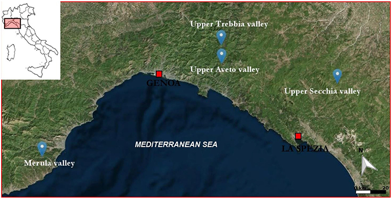
Figure 1. Localities and case studies cited in the text.
The following sections are arranged to illustrate and explain some of the different practices embedded in the local agro-sylvo-pastoral system in the past; each system has been characterized thanks to the multi-proxy studies of their environmental effects.
Firstly, the “alnocoltura” cultivation system recorded in the Upper Trebbia valley will be explained using both documentary and field sources (soil characteristics, pollen, and charcoal remains). Secondly, the “ronco” systems (of which the alnocoltura is a variant) will be explored analysing the historical cartographic series and archaeological features (i.e., stone cairns) considered an evidence of such temporary agriculture system. The local environmental effects of such woodmanship practices on vegetation cover and soil features and characteristics is underlined; in particular, effects of fires activities will be observed thanks to bio-stratigraphic remains (i.e., charcoal). Finally, past land uses and related fire regime characterisation is attempted in the last case study presented. In fact, in Merula valley, research show the transition from an ordered pastoral fire regime (documented in medieval and post medieval bylaw regulations) to present uncontrolled fires (Brotons et al., 2013); this transition was linked to different land uses (from a multiple agro-sylvo-pastoral system to the current abandonment of every kind of environmental management).
It is of interest to note that the first two case studies are included in a basin rich in wetlands and peatlands that are today protected by a system of Natural parks and Sites of Community Importance (SCI) and, as such, considered important sites of “natural” heritage.
The “Alnocoltura” Cultivation System
The term “alnocoltura” refers to a production and activation system that declined from the early decades of the Twentieth century. The name and specificity of this system are linked to a tree of the Betulaceae family, the grey alder—Alnus incana (L.) Moench—and its ability to fertilize the soil due to symbiosis with mycorrhizal fungi and nitrogen-fixing bacteria of the genus Frankia present in its radical nodules (Daniere et al., 1986; Uri et al., 2003).
This plant has a North-European continental-alpine distribution, but forms local and extensive populations also in the Alpine and Apennine mountains of northern Italy. Geobotanists have questioned about its origin at the western edge of the distribution range. For example, in Westphalia (Schwabe, 1985) its presence is certainly considered to be the result of crop management. On the contrary, in Italy, the geographical distribution of these woods is interpreted as anomalous, due to an unstable phase in the dynamic series of beech populations (Fagus sylvatica); distribution of grey alder is thus linked only to physiographic factors (Pignatti, 1998). Currently, in the study area, which corresponds to the Upper Aveto valley (Figure 1), the presence of the grey alder is represented by small discontinuous populations in the beech and turkey oak forest between 800 and 1,200 m asl (Bertolotto and Cevasco, 2000).
In the Upper Aveto valley the presence of the alnocoltura system has been identified thanks to a documentary research (Bertolotto and Cevasco, 2000). In particular, the study involved: (1) six hand drawn topographical maps dated around AD 1720 (scale of 1:9450) and their descriptions (Relazioni) commissioned by the local seigniorial family for the regulation of the use of temporary agricultural practices (mainly controlled fires) in this mountain estates, (2) a woodland survey promoted around AD 1817–1827 by the Forestry Administration of Sardinian Kingdom in order to control the local right to employ fire and/or grazing practices in wooded areas and (3) a description of the alnocoltura cycle documented by the Forestry Administration dated AD 1896. By way of these sources, it has been possible to follow the evolution of this particular crop cycle in the Upper Aveto valley, from at least the early decades of the Eighteenth century. The study of the documentary and cartographic sources allowed the identification of the cultivated parcels within this cultivation system, together with the phases of the cycles and the crops obtained.
This cycle, as was the case in the 1820s, was based on a short rotation coppicing of alder (3–12 years), which was followed by controlled fire of the cut branches and herbs layer for temporary sowing purposes (in this case oats, rye). According to Moreno et al. (1998) and Bertolotto and Cevasco (2000), this cultivation system sequentially involved: (1) coppicing of alder, (2) collection of regrowth for fuel and leaves for manuring, (3) stripping and burning of turfs, (4) sowing of temporary crops (mainly wheat or rye) and (5) cattle grazing (Figure 2). Grey alder was preferred not only for its capability as an actinorhizal N2-fixing tree species, but also for its fast growth on mineral soils (Tallantire, 1974; Saarsalmi, 1995). Soil fertility was also assured thanks to nutrients supplied by grazing animals and to the ash from the burning regime.
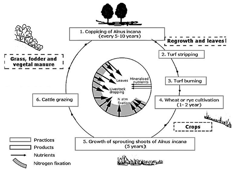
Figure 2. The alnocoltura cycle. Economic products (outer circle, dashed boxes), management practices (outer circle, solid boxes), and nutrient sources (inner circle). After Moreno et al. (1998) in Molinari and Montanari (2016, p. 32).
The alder parcels were therefore “activated” within a cycle comparable to the practices known throughout Europe as “stubble-burning” (ita. debbio) or French ecobuage (Sigaut, 1975).
The alder's fertilizing properties were known in the local naturalistic knowledge (LNK): they were applied not only by this particular practice, but also by planting alder in chestnut cultivations and burying leaves as fertilizer.
Traces of LNK can be found in the orally communicated cultural memory and also in the agronomic-botanical literature from the end of the Middle Ages, while the fertilizing properties of the species are not mentioned by the authors of the Classical Age. In this context, the adoption of the system in the Ligurian-Tuscan-Emilian Apennines could be linked to the major changes that occurred in the management of mountain pastures resources during the early Middle Ages, when intensive systems and multiples use of fodder resources were introduced, such as wooded pasture/meadow systems (Cevasco, 2007, p. 184–185; Moreno et al., 2019).
It was therefore necessary to confirm the existence of this practice through the study of bio-stratigraphic sources. For this reason, four sites (Pian dei Ronchi, Selvetta, Gosciona, and Ventarola) were selected and sampled (Molinari, 2009). Here the alnocoltura system was documented as having been performed during the Eighteenth and nineteenth centuries, according to documentary sources and compared with historical ecology observations of the current vegetation cover. Currently, all sample sites can be described as coppiced grey alder thickets, now abandoned, and characterized by the presence of fruit trees (pear, cherry tree), juniper and hawthorn that can be interpreted as traces of the alnocoltura system.
The analysis and comparison of bio-stratigraphic evidence with documentary and observational sources allows the effects identification of the cultivation cycle on the ecology of the present site, as well as to explain the functioning of the environmental system itself and finally the identification of archaeological traces left in soils and sediments.
According to Molinari and Montanari (2016) the presence in soils of such cultivation cycle can be detected using, in particular, pollen and charcoal remains.
The four selected soil profiles had quite similar features, with a thin Oa-horizon characterized by a dense root system and a well-developed A-horizon (Table 1 for in-depth description). Macroscopic charcoal fragments were present in the mineral horizons of Selvetta and Gosciona profiles. At Selvetta, thin black layers (a few millimetres thick) occurred at depths between 35 and 40 cm as sets of parallel horizontal layers in the soil profile and no earthworms were observed (Molinari and Montanari, 2016, p. 35). Radiocarbon dating corresponded with the chronology detailed in documentary evidence, with the exception of Pian dei Ronchi site (more ancient–iron age). Authors suggest that this section of the soil profile might has been mixed owing to agricultural activities.
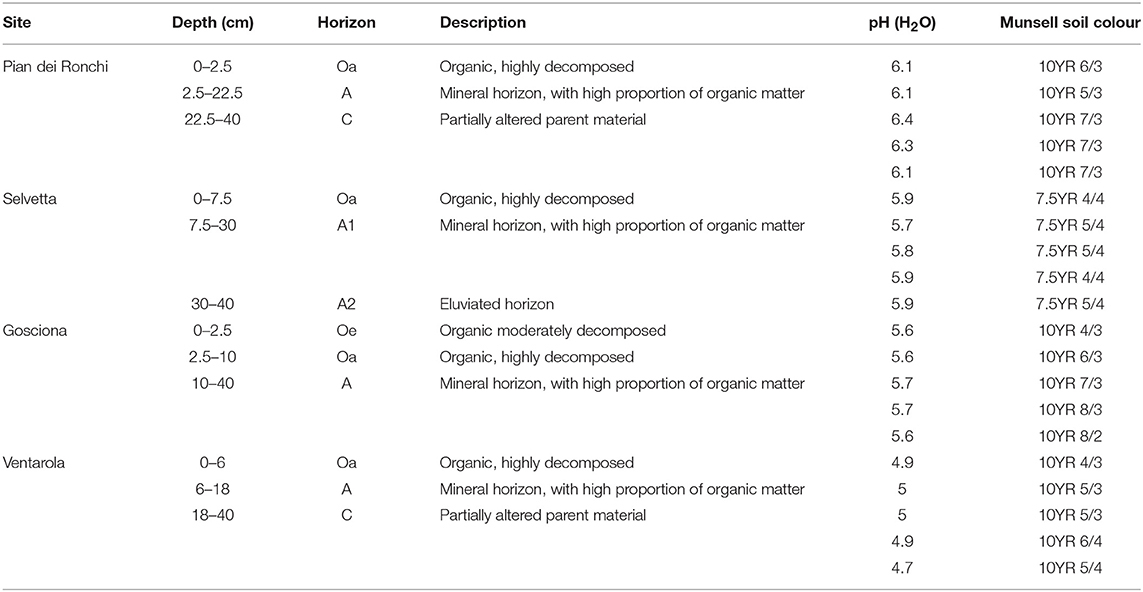
Table 1. Description of the soil horizons from the selected profiles as reported by Molinari and Montanari (2016, p. 33).
This study enabled the reconstruction of the past ecology of environmental resources exploited locally and demonstrated the different effects of multiple management practices on vegetation composition.
In particular, it has been possible to identify some features associated with the practice of alnoculture:
1) High percentages of herbaceous taxa and, in particular, of some anthropogenic pollen indicators [Cerealia type, Centaurea cyanus, Plantago lanceolata and P. major, Humulus/Cannabis type, Rumex, Galium, Asteraceae (mainly Cichorioideae), Urticaceae, Chenopodiaceae, and Cruciferae], testifying to the local presence of small open areas used for temporary agricultural practices.
2) An increase of Ericaceae percentages (mainly Calluna), indicating temporary grazing on the surrounding site and/or the use of controlled fire for agricultural purposes.
3) Low pollen percentages of Alnus due to the short-term coppicing (probably 3–12 years cf 1820s documentary sources) preventing pollen production.
4) High palynological richness, underlining an increase in biodiversity, probably due to local clearance and the presence of a patchy landscape created by the spread of multiple use practices.
5) High concentration of macroscopic charcoal fragments, indicating the use of controlled fire (Figure 3) (Molinari and Montanari, 2016).
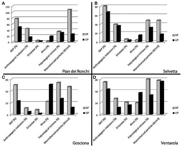
Figure 3. Comparison of pollen percentages and macrocharcoal (not identifiable) concentration (mean values) during the phase characterised by the alnocoltura practice (AP) and the unmanaged phase (UP) at the four selected sites (A–D) in Molinari and Montanari (2016, p. 39).
It is interesting to note that during the abandonment phase of the alnocoltura system, a decrease in the palynological richness occurs reflecting a significant reduction in biodiversity. Thanks to such results produced by Molinari and Montanari, a new interpretation of a pollen diagram published by Cruise (1990) from the peat bog Moglia di Casanova has been suggested. At this small mire a decline in Alnus, associated with an increase in Corylus, Ericacae, Cichorioideae and a peak in charcoal fragments (carbone in diagram) between 100 and 50 cm depth (Figure 4), seems to most likely be connected to the presence of temporary cultivation documented during the medieval and post-medieval periods (Cevasco, 2007). Similar patterns (a decline in Alnus pollen and a peak in Poaceae and Cerealia type) are also documented in the pollen diagram from Mogge di Ertola at the beginning of Eleventh century (Molinari and Montanari, 2016, p. 40; Cevasco, 2007).
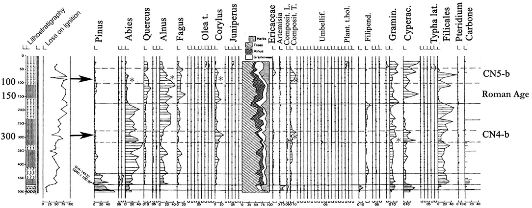
Figure 4. “Mogge di Casanova” pollen diagram (in Cevasco, 2007, p. 154 modified from Cruise, 1990). CN5b corresponds to Middle ages. Signaled by “*” some interesting peaks of percentages pollen.
The Practice of “Ronchi”
The alnocoltura system presented in the previous section can be considered as a variant of the more general temporary cultivation system named “ronco”. The term “ronco” is frequent in post-medieval documents and indicates a particular multiple production system that involves a cyclical soil hoeing for the sowing of cereals (i.e., rye and/or oats) through different practices of controlled fire. The reintegration of fertility of the parcel subjected to the “ronco” is assured by the long cycle of fallow land when left as rangeland. This practice of temporary agriculture was very common in the eastern Ligurian Apennines until the end of the nineteenth century (Moreno, 1985) and its effects were certainly important both on plant and animal populations, including birdlife (Cevasco, 2007, p. 187, Moreno, 2018).
Archaeological evidence of “ronco” practices has been uncovered on the site of “Pian delle Gròppere” (1,225 m asl), in the municipality of Casanova di Rovegno located in the Upper Trebbia valley (Figure 1).
This area, rich in surface Palaeolithic stone artefacts (Maggi and Galimberti, 1987), was the subject of a multidisciplinary investigation project in 2000 (Roccabruna project) involving different Universities (Genoa, Padua, Toulouse, Nottingham) and the Archaeological Superintendent of Liguria. The site is part of an ancient common land belonging to the inhabitants of the parish of Casanova di Rovegno that was used as summer pasture until the 1970s (Cevasco, 2004, p. 162).
The investigated area is a large clearing in the beech wood that characterize these slopes currently. The clearing is bordered to the east by pine plantations established in the first half of the Twentieth century, with subsequent additions thereafter. In the Trebbia valley, the dominant reforestation species are the Black pine (Pinus nigra) and Scots pine (Pinus sylvestris). The soil is subjected to strong erosion, and as such, the vegetation cover is discontinuous. There is an alternation between areas of bare ground (more or less clayey/pebbly) with moor land characterized by heather (Erica herbacea, Calluna vulgaris), juniper (Juniperus communis), and hairy greenweed (Genista pilosa) and a more or less thick herbaceous layer, depending on the shrubs density (Guido et al., 2002, p. 118).
The few patches of grassland are the remnants of a larger ancient grassland continuously documented by cartographic sources since at least the 1820s (Table 2) (Cevasco, 2004, p. 162).
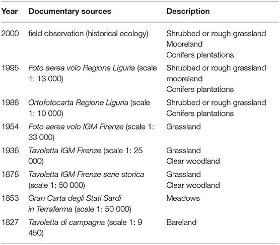
Table 2. Example of “filtraggio cartografico” (topographical maps historical series: 2000-1827) for the “Pian delle Gròppere” site.
Surrounded and partially covered by moor land, many stone mounds (cairns = dial. “groppere”) were the subject of archaeological excavation in 2000 (site T1 in Figure 5) that provided possible sedimentary evidence of past agro-forestry-pastoral activities.
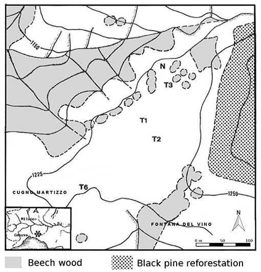
Figure 5. Localization of sample sites in Guido et al. (2002). Signale by “*” the site localation.
The investigated stone mound is positioned within an alignment of three similar structures; the northern half of T1 has been stratigraphically excavated (Figure 6A). The Stratigraphic Units described in Paltineri (2002) and Campana and Cevasco (2001) are listed below.
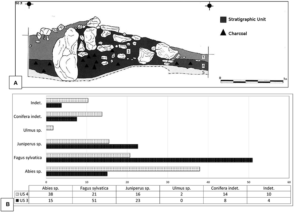
Figure 6. (A) T1 soil profile in Paltineri (2002) with relative stratigraphic units and presence of buried charcoals representation of charcoal fragments presence; (B) Results of anthracological analysis of US 3 and US 4 (percentages).
US1 = sandy-silty granulometry, light brown colour, contains few charcoals. A sliver of red jasper comes from this unit.
US 2 = stones of various sizes represent the collapse of the US 3 structure.
US 3 = stone mound. The base of the stone mound is formed by large stones (50 cm) that, in some cases, sink into the substrate; the inner part of the pile is instead characterized by smaller stones (25/30 cm). The ground included between the stones has a sandy-silty granulometry and dark brown colour: it contains many charcoals (1 mm).
US 4 = sandy-silty granulometry. It contains many charcoals between 1 mm and 1 cm.
US 5 = Substrate.
Charcoal remains recovered in US 3 and US 4 have been analysed and results are shown in Figure 6B.
A total of 56 charcoal fragments from US 3 have been identified showing the presence of four taxa: fir (Abies sp.), juniper (Juniperus sp.), beech (Fagus sylvatica) and conifers not better identified but probably of the same taxa. One of this charcoal remains dated back to 1340 ± 40 BP (cal. AD 640–770: Beta 146910).
Sixty-Five charcoal fragments found at the same level, but outside the stones pile (US 4), are qualitatively the same of US 3 but with the addition of Elm (Ulmus sp.). However, there is a difference in the percentage of beech and fir in these different US: within the stone pile (US 3) the beech is the most frequent species (51%), whilst fir is more present outside the stone heap (US 4; 38%) (Figure 6B).
This structure has been interpreted as a clearance cairn and provides clues of a phase of early medieval soil cultivation: in particular, temporary agriculture characterized by cutting cycles, fire, use and abandonment (long fallow cycle?) (Figure 7).
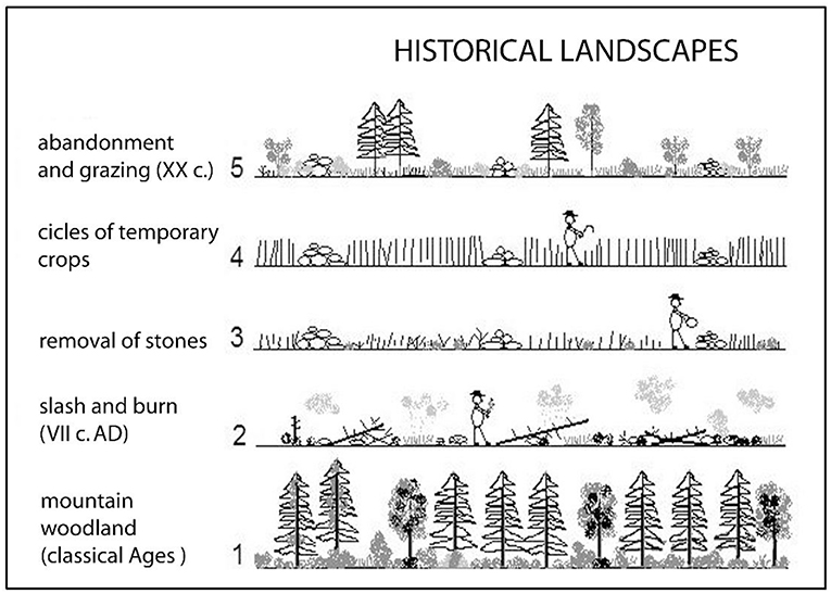
Figure 7. The reconstruction of a “ronco” in “Pian delle Gròppere” in a sketch by J.P. Métailié, September 2000 in Moreno and Montanari (2008).
The US 3 corresponds to the cleaning phase of the area (mostly by burning the herbs layer and shrubs) which is subsequently obliterated by the accumulation of surrounding stones (upper part of mound). The stratigraphy outside the clearance cairn shows different features: US 4 can be interpreted as previous of US 3. In fact, outside the clearance cairn, the activities producing US 3 may not have been preserved (cultivation activities = US use interface).
Although this hypothesis should be supported by a radiocarbon dating of US 4, the anthracological results could be a clue in this direction. It is noted a progressive reduction of fir during the medieval period in favour of beech and chestnut mainly due to cultivation activities.
US 3 contains a greater number of beech charcoal than the US 4 and this could be interpreted as different chronologic phases.
In the Gròppere plateau other evidences show the presence of past agricultural activities.
Near T1, another pedologic pit has been practiced (T2 see Figure 5 for the sample location and Table 3 for soil profile description); the aim was to obtaining indications from a stratigraphy that could be considered to correspond to that of the T1 site, but less disturbed.
Table 3. Description of the soil horizons from the selected profile (T2) in Ottomano (2002).
The examined level mainly consisted of pedorelicts derived from the reorganization of pre-existing soils and, therefore, it has a colluvial origin. A similar origin is consistent with the presence of concentrated minute charcoals between −25 and −30 cm. There are no coatings of any kind, neither in the pedorelicts, nor in the porosity, and this confirms the interpretation of this level as a B/C soil horizon that evolved above the colluvial deposits.
Along the section, 53 fragments of charcoals were recovered and analysed. Silver fir was the most frequent species, with the exception of the first 10 cm of soils where a fragment of chestnut was found, whilst no beech charcoal was found. The pollen content of the soil section was examined in four levels (12, 25, and 40 cm): the pollen concentration was always very low and in the deeper samples the pollen was almost absent. However, it is clear that the soil—up to about 25 cm deep—recorded a situation similar to the current one, with prevalence of moorland with heather (Erica herbacea, Calluna vulgaris), accompanied by Poaceae, Cyperaceae and the presence of pine trees in the surrounding area (plantation from the first half of the nineteenth century on the adjacent ridge, with Pinus nigra and P. sylvestris) (Guido et al., 2002).
On the same plateau, along the old communal muleteer route from Casanova to Rezzoaglio (just below Pian delle Groppere), another soil profile (T6) was documented (Figure 5 for sample location and the list below for stratigraphic description) revealing the presence of slope terracing. In particular, the US 5 has been dated to AMS 790 ±80 BP (= Cal 2 sigma AD 1040–1380; BETA 146909). Another charcoal has been dated to 960 ± 100 BP (= Cal 2 sigma AD 890–1270; BETA 158362).
US1 = sandy granulometry; dark grey colour, fine roots
US 2 = heterogeneous stones and angular blocks (up to 60 cm in size) in poor sandy-loamy matrix of yellow/brown colour (10YR 5/6); lower limit, clear, wavy.
US 3 = free-silty, black colour (10YR 2/1); expressed minute angular polyhedral aggregation; poor skeleton, minute; fine, common roots; minute and medium common charcoals; lower limit, clear, wavy.
US 4 = sandy texture; reddish-brown colour; lower limit clear and wavy; contains many stones of about 10 cm in size.
US 5 = angular stones, in sandy-silty matrix of black colour (10YR 2/1); expressed minute angular polyhedral aggregation; fine, common roots, minute, and medium common charcoals.
The US 5 was also sampled in order to perform micromorphologic analysis (Ottomano, 2002), allowing the interpretation of the organic horizon (US 5) as a colluvial soil, formed in a temperate climate with contrasting seasons. It presents some specific characteristics of the Bw (t) horizons of the inceptisols. Anthropized soils with similar characteristics are common in the Neolithic but considered exceptional for a mountain area and for such a recent period (Middle Ages).
Although it is still difficult to connect all the different information gathered from archaeological surveys, it seems to be clear that agro-sylvo-pastoral activities had an important role in this area concerning soils and sediments formation and transformation over time. These activities seem to be also the main responsible for the production and accumulation of micro and macro charcoal in soils and sediments. In fact, within these activities, the use of fire played an important role as also highlighted by the local place name: “Pian de Furnàsci” (trad. Plateau of “furnaces”) with which local informants still indicate the “Gròppere” site; this could confirm the use of fire confined in “patches” subjected to temporary agriculture still during the nineteenth century (Cevasco, 2007, p. 93).
The practices of confined fire, namely the “ronco” system, are linked to the individual occupation of common lands, in particular when devoted to grazing transhumance flocks.
In the post-medieval ages, the flock movements involved conflicts between the Apennines communities and parishes. In this framework, disputes for the borders also arose between the state entities and the local lordships that manteined the jurisdiction of the grazed area.
This was common in the Trebbia Valley, but also for other North-Western Apennines areas, such as in the territories of the surrounding leading city-states of Parma, Reggio or Lucca (Moreno et al., 2019).
Thanks to such disputes, it is possible to find in different archives (local and national) series of manuscript maps that provide detailed evidence of management practices marking the mountain pastoral resources ecology (grassland, moorland, and beech wooded meadows). One particularly excellent example, is a view map (a watercolour and ink drawing date back to the first half Seventeenth century) representing the head of the Upper Secchia Valley (Figure 8) in the Appenines watershed between Liguria, Tuscany and Emilia-Romagna. It shows the localisation of some temporary crop field (probably rye) or “ronchi,” practiced on the slope of “Monte di Cento Croce” and “Monte di Spiaggia Bella.”
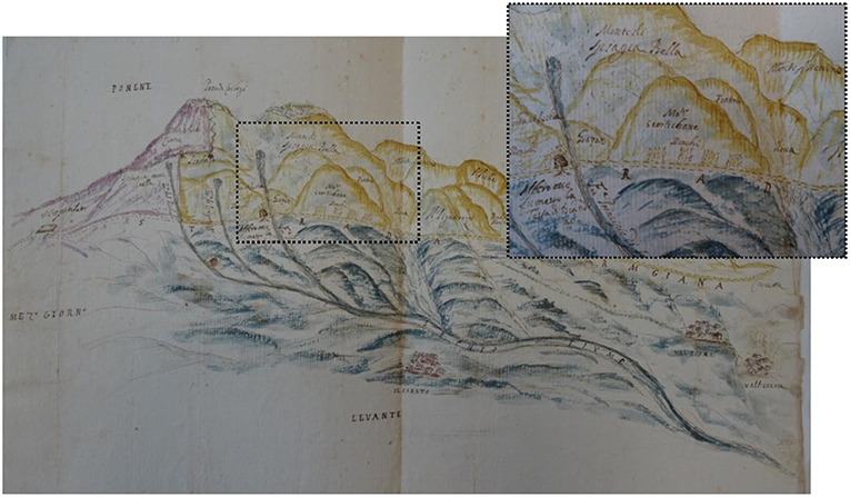
Figure 8. ASP. Confini, B205/8, dis. 896. Upper Secchia valley: detail of an anonymous manuscript map; half 17th c. (attributed).
The parcels are distributed along the muleteer road called “Strada Parmigiana” linking Parma with the Magra Valley and are represented by dotted areas. The same area is shown in a sketch map almost contemporary (possibly produced by a professional painter) in which the sowed parcel of “ronco” are presented in a magnification way representing a realistic view of this detailed landscape (Figure 9).
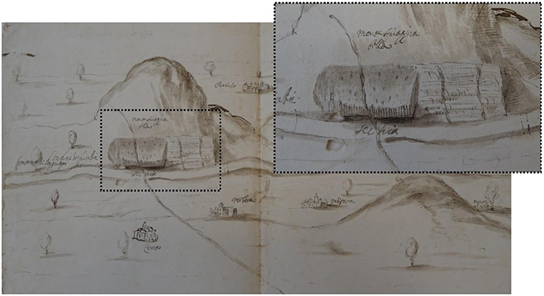
Figure 9. ASP. Confini, B205/8, dis. 900. Upper Secchia valley: detail of an anonymous manuscript map; half 17th c. (attributed).
Comparing the spot of such view maps with current technical regional maps is possible to note that the mapped mountain reaches 1,630 m asl and the indicated “ronchi” sites are located around 1,300 m asl; even if at high altitude, such cultivation system was possible and strictly linked with pastoral activities. The ecology of such mountain, mostly dominated by wooded grassland pastures, and their management practices what kind of soil could have produced?
Historical Variation in Fire Regime
This case study sought to explore different approaches to identifying and characterizing the ecology and soils of sites bearing ancient (historical) and recent (mostly post-cultural) woodland. It is a problem recently discussed at an international meeting held in Padova (18th−20th April 2018 “Into the wood. Overlapping perspectives on the history of ancient forests”) (Cevasco et al., 2018).
This research started in 2016, observing the woodland cover of the watershed of the Merula valley in Western Liguria Riviera recently classified as “mixed woodland” (with Quercus pubescens) by a regional government land use map (see the list of analysed maps in particular cf n°10). It was noted that on the same slope the oak population reacted differently to water stress due to the scarcity of rainfall in the summer of 2015. From this starting point, an interdisciplinary survey was subsequently conducted in order to investigate the ecology of the site aiming to relate the present oak ecological behaviour within the past land use history of the site.
Results from archaeological surveys, soil profiles and present vegetation observations have been compared with land use and plant cover as shown in a series of topographical maps from different dates. A list of the analysed maps (1750–2015 A.D.) is shown below and the comparisons in Table 4. Field observations undertaken during the winter of 2017 are summarized in Table 5. This section summarizes some of the first results of this project that is still in progress concerning the underlying role of pastoral fire practices or the historical variation in fire regime (Cevasco et al., 2018).
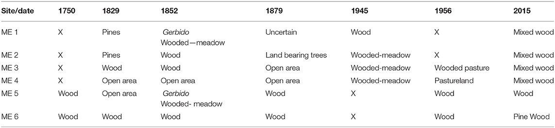
Table 4. Merula Valley. Land use/cover history at the studied sites: results of map comparison (1750–2015 A.D).
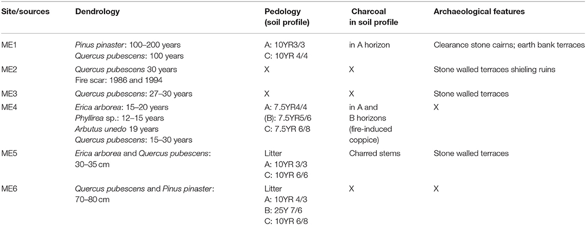
Table 5. Merula Valley (cf. Figure 4). Archaeological features from field survey, soil profile, and current vegetation (winter, 2017).
1. 1750 (around): Carta Topografica in misura del Litorale della Riviera di Ponente, Parte V, Ufficio Topografico del Corpo di Stato Maggiore del Regno di Sardegna, ms, 1:9450
2. 1829: Ricognizioni eseguite alla scala di 1/20.000 che comprendono le due Riviere degli ex Stati Sardi e parte delle attuali Provincie di Alessandria e di Pavia, 1:20.000
3. 1852: Gran Carta degli Stati Sardi in Terraferma di S.M. il Re di Sardegna, 1:50.000
4. 1879: Tavole della Carta d'Italia dell'Istituto Geografico Militare, Foglio 92 n. III, Alassio (1:50.000)
5. 1944: Aerial photograph, Royal Air Force flight RAF, Istituto Geografico Militare
6. 1936: Nuovo Catasto Terreni–Stellanello/Andora 1:2000
7. 1996–2013: Carte delle Aree percorse dal fuoco, Corpo Forestale dello Stato e Regione Liguria (1:2000)
8. 2007–updated2016: Carta Tecnica Regionale, Liguria, 1:10.000 ed.
9. 2013: Tipi Forestali della Regione Liguria (1: 25.000)
10. 2015: Carta Uso del Suolo Regione Liguria (1:10.000).
Overall, the comparison between documentary, observational and bio-stratigraphical sources made it possible to organize the six sites into two groups. The sites belonging to the first group (ME1 and ME6) are characterized by a continuity of land use and management practices from the second half of the Eighteenth century. These are wooded pastures, presenting in the past some ecological features of savannah type called “land bearing trees” (sensu Rackham), in particular pines. Explored sites show some present living veteran specimens (cf Pinus pinaster of 100–200 years old and Quercus pubescens of about 100 years). It is of interest to note that the presence of clearance stone cairns in ME1 is an indication of the production of hay that supports the hypothesis of the presence of a wooded pasture/meadow in this site. Moreover, a preliminary botanical survey of the ground flora—not unexpectedly—documented a mix of both wood habitat species and meadow species. A soil profile clearly showed a forest soil with traces of recent fire (charcoal in the most superficial part of the A horizon). Similarly, in ME6 the woodland canopy is documented since 1750 AD and the series of cartographic sources shows a clear continuity of land use and land cover. At present we find a mixed population of downy oak and maritime pines (with individuals estimated to be around 100 years old), as well as the soil profile showing a mature woodland soil (Figure 10).
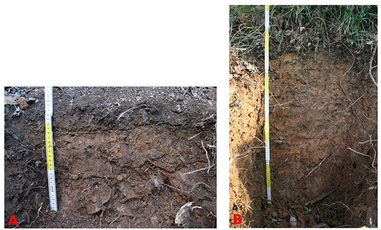
Figure 10. A comparison of two soil profiles highlighting different past land use. (A) ME6 = post cultural soil; (B) ME4 = soil in a wooded area (in continuity).
These characteristics of continuity make it possible to define these two sites as an example of “ancient forests” (“ancient woodland,” sensu Watkins, 1990).
The second sites group (ME 2,3,4,5) is instead characterized by a strong discontinuity in vegetation cover and management practices in the last 250–300 years. In particular, in the ME 2, 3, and 5 sites there is a changing in vegetation cover: from a wooded land to an open area and then again a wooded vegetation. Present vegetation cover has often colonized abandoned terracing and is subjected to a fire regime characterized by uncontrolled fires, on an increasingly frequent basis.
Since 1969, the Forest Administration recorded in a database-map the “burned” areas; this archival source permitted the identification of at least 14 fires that affected the vegetation in the investigated area. At the ME2 site, oak trees assumed the shape of coppiced stumps (“coppice by fire”) and show irregular rings growth consistent with recurrent fire scars. The dendrochronological analysis of some of these oaks made it possible to identify, for example, traces of past severe fire events attributable to 1986 and 1994, respectively.
Concerning the ME5 site, cartographic analysis proves the presence of an “ancient woodland” site. In 1750 A.D. (cf. analysed map list n°1) this area is shown as a wooded site, and in the following decades its land uses changed. In the 1852 map, it is documented as a wooded pasture site. This discrepancy could be due to the application of different classification methods of the same (continuous) land cover by surveyors evaluating the density of trees differently. At this site, the continuity of the tree population is evident. Field observations show a terraced slope, with poor herbaceous cover presenting indicator species such as Coronilla emerus, confirming a thermophilous deciduous woodland habitat; the ancient wood cover now appears populated by Mediterranean shrubs repeatedly burnt under the present wild fire regime. These “uncontrolled” fires often affected the herbaceous layer and the subsequent scrub spread in the last century as a result of the abandonment, not only of agro-silvo-pastoral practices, but also of the preceding pastoral fire regime.
In the archival sources—in particular by-laws—for the Merula valley the presence of controlled fire practices together with rules that regulated them since the Middle Ages are testified to. For example, in some chapters of the Stellanello community by-laws (dated to 1317 AD and updated until the end of Eighteenth century) the uses of controlled fire are described, mostly linked to the use of common pastoral resources. Most of the valley was indeed subjected to transhumant movement regulated by access to pastoral resources known as the “bandita” system, which consisted of a temporary renting of common land mainly used for grazing, an area in which the use of pastoral controlled fire was permitted.
In the Merula valley, changes in fire regimes are related both to vegetation dynamics and to the history of the complex system of access rights to pastoral resources for the winter/seasonal grazing of flocks, particularly in the common areas.
In the international literature, the use of fire is recognized as one of the most important factors that influenced the forest composition and distribution in temperate areas (Vanniere et al., 2008). Nowadays, in order to recreate the ecological effect of fire and encourage sustainable socio-ecological systems, some experiments of controlled fire are conducted in different European areas (Métailié, 1992;Bürgi et al., 2013).
The research presented here started from field observations, with the intention of seeking to interpret why the same oak population, on the same slope, had different responses to water stress. This is due to the different land use and management practices that affected this area in the past.
Although today this watershed is described and classified as belonging to the same forest type, the ecological behaviour is different: it does not respond to ecological-structural models but is the result of the transformations of land use and management practices over last 100 years.
Conclusion
The outlined researches have helped to shed new light on some of the possible origins of charcoal in soils and sediments. In all the case studies explored, it was shown that specific management and activation practices of the environmental resource have had, among the different effects, the production of charcoal and especially microcharcoal.
The perspective opened by the historical ecology approach, the micro geographic-historical analysis and therefore by Environmental Resources Archaeology makes it possible to re-interpret the environment in a more precise and complex historical, social and cultural dimensions. In this way, it is possible to avoid generalized evolutionary narratives of the environmental processes in which the social component is flattened and conventionally reduced to a “disturbance” factor (i.e., “anthropic disturbance”, “anthropic exploitation”). In this way, it is possible to overcome the dichotomous vision established by man vs. nature and their relative derivations. The misunderstanding of environmental dynamics has had dangerous consequences in the application of research to conservation politics as Oliver Rackham pointed out in many of his leading writings. Amongst the investigated case studies—which are mostly included in natural parks and in restricted areas due to its naturalistic value—agricultural soils can be found currently covered by moorlands (i.e., Gròppere) or pastoral soils under a tree canopy considered and classified as woodland or secondary woods (Merula valley sites). The “institutional” environmental classification fails to take into account the history of the individual site (or individual landscape), a possible consequence of which is to consider stable soils and slopes now subjected to re-naturalization processes. Instead, the abandonment of local agro-sylvo-pastoral practices seems to be one of the main causes behind the loss of historical biodiversity, the increase in hydrogeological instability and the risk of fires (Cevasco et al., 2015).
Another problem is the difficulty of identification and characterisation of agro-sylvo-pastoral activities due to their current abandonment, especially fire practices. The case studies presented here, however, have shown that soils and sediments, thanks to anthracological and palynological evidence, record the environmental effects of such practices. In particular, the record of their effects on the overall local ecosystem (activation) was found. Other sources should be examined in more depth (for example the chemical characteristics of the soils as pH, phosphates etc.) and be encouraged in future research in this direction. Their analysis must take place with a multi-source approach at the site-level, using a regressive analysis (to follow the discontinuities and continuity of processes or environmental effects up to the present ecosystem).
Therefore, a re-definition of the historical factors that produced and maintained the characters of the present environmental system (and so the soils, sediments, vegetation cover, and animal stand) during historical time is required to better understand and sustainably manage those Mediterranean mountain landscapes for the future preservation of unique cultural and environmental heritage.
Author Contributions
The author confirms being the sole contributor of this work and has approved it for publication.
Conflict of Interest Statement
The author declares that the research was conducted in the absence of any commercial or financial relationships that could be construed as a potential conflict of interest.
Acknowledgments
I would like to thank the LASA team for the developed research and for making the results available. A special thanks to the State Archive of Parma for the cartography and Robert Hearn and Nicola Gabellieri for the English translation.
References
Bertolotto, S., and Cevasco, R. (2000). Fonti osservazionali e fonti testuali: le Consegne dei Boschi e il sistema dell'alnocoltura nell'appennino ligure orientale (1822). Quaderni storici. 103, 1, 87–108. doi: 10.1408/10276
Brotons, L., Aquilué, N., De Cáceres, M., Fortin, M.-J., and Fall, A. (2013). How fire history, fire suppression practices and climate change affect wildfire regimes in Mediterranean landscapes. PLoS ONE 8:e62392. doi: 10.1371/journal.pone.0062392
Bürgi, M., Gimmi, U., and Stuber, M. (2013). Assessing traditional knowledge on forest uses to understand forest ecosystem dynamics. Forest Ecol. Manage. 289, 115–122. doi: 10.1016/j.foreco.2012.10.012
Campana, N., and Cevasco, R. (2001). “Un'area di interesse archeologico ambientale: studi di ecologia storica a “Pian delle Gròppere” (Casanova di Rovegno - GE). In Atti del convegno internazionale patrimonio storico-ambientale. Esperienze, progetti e prospettive per la valorizzazione delle aree rurali, eds. P. Stringa, D. Moreno. Rapallo: Officine Grafiche Canessa. 225–232.
Cevasco, R. (2004). “Multiple use of tree-land in the Northern Apennines during post medieval times. Linking clues of evidence”, in Ligurian Landscapes: Studies in Archaeology, Geography and History, eds. R. Balzaretti, C. Watkins, M. Pearce, University of London: Accordia Research Institute, 10, 155–177.
Cevasco, R., Hearn, R., and Moreno, D. (2015). Biodiversification as an Historical Process: an Appeal for the Application of Historical Ecology to Bio-Cultural Diversity Research. Biodiversity and Conservation, Dordrecht: Springer.
Cevasco, R., Montanari, C., and Pescini, V. (2018). “On the ecology of Ancient and Recent Woodland: the role of the historical approach”, in into the Woods Overlapping Perspectives on the History of Ancient Forests, eds. S. Paradis-Grenouillet, C. Aspe, and S. Burri. (Versailles: Quae Edition 14).
Cruise, G. M. (1990). Pollen stratigraphy of two Holocene peat sites in the Ligurian Apennines, northern Italy. Rev. Palaeobot. Palynol. 63, 299–313.
Daniere, C., Capellano, A., and Moirud, A. (1986). Dynamique de l'azote dans un peuplement natural d'Alnus incana (L.) Moench. Acta Oecologia. 7, 165–175.
Dazzi, C., and Lo Papa, G. (2015). Anthropogenic soils: general aspects and features. Ecocycles. 1, 3–8. doi: 10.19040/ecocycles.v1i1.23
Guido, M. A., Scipioni, S., and Montanari, C. (2002). II paesaggio colturale nei dintorni di casanova di rovegno (GE) dal VII-VIII sec. d.C.: dati archeobotanici per l'area di pian delle groppere. Archeologia Postmedievale. 6, 117–124. doi: 10.1400/210850
Lehmann, J., Kern, D. C., Glaser, B., and Woods, W. I. (2003). Amazonian Dark Earths: Origin Properties Management. Dordrecht: Springer. doi: 10.1007/1-4020-2597-1
Maggi, R. (2015). I Monti Sono Vecchi. Archeologia Del Paesaggio Dal Turchino Alla Magra, Genova: De Ferrari editore
Maggi, R. E., and Galimberti, C. (1987). “Alta Val Trebbia”, in Archeologia in Liguria III. 1. Scavi e Scoperte 1982-86, Preistoria e Protostoria, eds. P Melli e, A Del Lucchese (Genova: Soprintendenza della Regione Liguria, 85–90.
Métailié, J. P. (1992). Du Feu Du Berger Au Feu Dirigé Dans Les Pyrénées-Orientales (XIX-XX siécle). Le Cheminement D'une Pratique Traditionnelle Controversée. Paris: Actes du Séminaire du Groupe d'Histoire des Forêts Françaises.
Molinari, C. (2009). Ricerche Palinologiche Per L'identificazione Di Sistemi Agro-Silvo- Pastorali Storici. [PhD dissertation]. [Genoa (IT)]: University of Genoa
Molinari, C., and Montanari, C. (2016). Interdisciplinary approach for reconstructing an alder-based historical agricultural practice of the Eastern Ligurian Apennines (NW Italy). Environmental Archaeology. 21, 31–44. doi: 10.1179/1749631414Y.0000000056
Montanari, C., Scipioni, S., Calderoni, G., Leonardi, G., and Moreno, D. (2002). “Linking anthracology and historical ecology: suggestions from a postmedieval site in the Ligurian Apennines,” in Charcoal Analysis: Methodological Approach, Palaeoecological Results and Wood Uses: Proceedings of the Second International Meeting of Anthracology (Oxford: Archaeopress, 235–241.
Montanari, C., and Stagno, A. (2015). “Archeologia delle risorse: tra archeologia ambientale, ecologia storica e archeologia rurale”, in Archaeology of Europe's Mountain Areas: Methods, Problems and Case Studies, eds. U. Moscatelli, A. Stagno. Il capitale culturale, 12, 503–536. doi: 10.13138/2039-2362/1301
Moreno, D. (1985). “The agricultural uses of tree-land in the north-western Appennines since the middle ages”, in History of Forest Utilisation and Forestry in Mountain Regions. (Zurich: Symposium an der ETH), 77–88.
Moreno, D., Cevasco, R., Bertolotto, S., and Poggi, G. (1998). “Historical ecology and post-medieval management practices in alder woods (Alnus incana (L.) Moench) in the northern Apennines, Italy,” in Introduction - Historical Ecology and European Woodland, eds C. Watkins and K. Kirby (Wallingford: CAB International, 185–201.
Moreno, D., Cevasco, R., Pescini, V., and Gabellieri, N. (2019). “The archaeology of woodland ecology: reconstructing past woodmanship practices of wooded pasture/meadow systems in Italy”, in Silvicultures: Management and Conservation, eds F. Allende, G. Gomez, N. Lopez. InTech Edition
Moreno, D., and Montanari, C. (2008). Más allá de la percepción: hacia una ecología histórica del paisaje rural en Italia. Quadernos Geograficos. 48, 29–49. doi: 10.30827/cuadgeo.v43i0.1108
Moreno, D., Montanari, C., Stagno, A. M., and Molinari, C. (2010). “A plea for a (New) environmental archaeology: the use of the geographical historical microanalytical approach in mountain areas of NW Italy”, in Archéologie De La Montagne Européenne, eds. S Tzortzis. and X. Delestre (Condé-sur-Noireau: Actes de la table ronde internationale de Gap), 75–83.
Ottomano, C. (2002). La micromorfologia come strumento per la ricostruzione paleombientale. Due esempi dall'appennino genovese: la carbonaia del castello della pietra (Vobbia-GE) e le sezioni di Pian delle Gròppere (Casanova di Rovegno-GE). Archeologia Postmedievale. 6, 75–82. doi: 10.1400/210853
Paltineri, S. (2002). Territorio come manufatto e manufatti nel territorio: i cumuli di spietramento a Pian delle Gròppere. Archeologia Postmedievale. 6, 83–87. doi: 10.1400/210846
Peterken, G. F. (1975). “Historical approach to woodland ecology and management”, in Besdford Purlieus, its History, Ecology and Management, eds. G.F. Peterken, R.C. Welch, (Huntingdon: Institute of Terrestrial Ecology, Monks Wood Experimental Station, Symposium n) 7.
Rackham, O. (1976). Trees and Woodland in the British Landscape. London: Archaeology in the Field Series.
Rackham, O. (1980). Ancient Woodland.its History, Vegetation and Uses in England, London: Edward Arnold.
Raggio, O. (2004). “Microhistorical approaches to the History of Liguria; from Microanalysis to Local History. Edoardo Grendi's Achievements”, in Ligurian Landscape. Studies in Archaeology, Geography and History in Memory of Edoardo Grendi, eds. R. Balzaretti, M. Pearce, C. Watkins. (London: Accordia Research Institute, University of London), 97–104.
Russell Emily, W. B. (1997). People and Land Through Time. Linking Ecology and History, New Haven and London: Yale UP.
Saarsalmi, A. (1995). Nutrition of Deciduous Tree Species Grown in Short Rotation Stands. Academic dissertation. Faculty of Forestry, Finland: University of Joensuu, Joeensuu.
Schwabe, A. (1985). Monographie Alnus incana - reiche waldgesellschaften in Europa. variabilität und ähnlichkeiten einer azonal verbreiteten gesellschaftsgruppe. Phytocoenologia. 13, 197–302. doi: 10.1127/phyto/13/1985/197
Sigaut, F. (1975). L'agricolture Et Le Feu. Role Et Place Du Feu Dans Les Techniques De Préparation Du Champ De L'ancienne Agriculture Europèenne. Paris-La Haye: Mouton & Co.
Tallantire, P. A. (1974). The palaeohistory of the grey alder (Alnus incana (L.) Moench) and black alder (A. glutinosa (L.) Gaertn.) in Fennoscandia. New Phytologist. 73, 529–46. doi: 10.1111/j.1469-8137.1974.tb02131.x
Uri, V., Lõhmus, K., and Tullus, H. (2003). Annual net nitrogen mineralization in a grey alder (Alnus incana (L.) Moench) plantation abandoned agricultural land. Forest Ecol. Manage. 184, 167–176. doi: 10.1016/S0378-1127(03)00210-X
Vanniere, B., Colombaroli, D., Chapron, E., Leroux, A., Tinner, W., and Magny, M. (2008). Climate versus human-driven fire regimes in Mediterranean landscapes: the holocene record of lago dell'Accesa (Tuscany, Italy). Quat. Sci. Rev. 27, 1181–1196. doi: 10.1016/j.quascirev.2008.02.011
Keywords: woodmanship practices, macro/microcharcoal, Environmental Resource Archaeology, historical ecology, western mediterranean mountains
Citation: Pescini V (2019) Which Origin for Charcoal in Soils? Case-Studies of Environmental Resources Archaeology (ERA) From the Ligurian Apennines, Seventh to the Twentieth Century. Front. Environ. Sci. 7:77. doi: 10.3389/fenvs.2019.00077
Received: 15 November 2018; Accepted: 17 May 2019;
Published: 19 June 2019.
Edited by:
Clare Alexandra Wilson, University of Stirling, United KingdomReviewed by:
Achouak Arfaoui, University of Jendouba, TunisiaOliver Nelle, Landesamt für Denkmalpflege im Regierungspräsidium Stuttgart, Germany
Copyright © 2019 Pescini. This is an open-access article distributed under the terms of the Creative Commons Attribution License (CC BY). The use, distribution or reproduction in other forums is permitted, provided the original author(s) and the copyright owner(s) are credited and that the original publication in this journal is cited, in accordance with accepted academic practice. No use, distribution or reproduction is permitted which does not comply with these terms.
*Correspondence: Valentina Pescini, dmFscGVzODdAZ21haWwuY29t