 Kaiming Li
 Huizhi Geng1*
- 1College of Architecture and Urban Planning, Tongji University, Shanghai, China
- 2School of Social Development, East China Normal University, Shanghai, China
- 3Antai College of Economics and Management, Shanghai Jiao Tong University, Shanghai, China
- 4College of Tourism and Urban Rural Planning, Chengdu University of Technology, Chengdu, China
Under rapid urbanization, rural China has undergone a drastic transformation, especially in the metropolis. Revealing the evolution laws of rural settlements is critical for effectively providing references. Although many previous studies demonstrated the transformation laws of rural settlements from multiple scales, few focused on the spatial differentiation within the metropolis. This study constructed the spatial conversion intensity index, conversion structure significance index, and landscape metrics to investigate the spatial differentiation characteristics, classify the transformation patterns, and reveal driving mechanisms of rural settlements in the Pudong district at the township level. The results demonstrated a significant decrease in the size of settlements, and the values decreased from urban-rural fringe to exurban area. The conversion structure of settlements varied within urban-fringe, suburban, and exurban areas. The morphology of settlements became more regular and compact, but to a varying degree. Based on these findings, three transformation patterns were summarized: the rapid disappearance pattern, the physical decay pattern, and the orderly transformation pattern. Further analysis indicated that they were mainly caused by urban encroachment, limitation of geographic conditions, and planning policies separately. These conclusions reveal the spatial differentiation characteristics of rural settlements in the metropolis of developing countries and provide scientific guidance for sustainable rural development.
1 Introduction
Driving by rapid urbanization and industrialization, most countries around the world have experienced a drastic process of rural settlements transformation (Long, 2014; Jiang G. et al., 2016). It is more evident in China since the reform and opening up in 1978 (Liu Y. et al., 2014; Liu et al., 2017). Its urbanization rate had increased from 17% in 1978 to 60% in 2020, and the average annual growth rate of industrial added value during this period is 14.6% (Jia et al., 2020). Against this background, China has also changed from a native-rural society to an urban-rural society (Liu and Wang, 2018). Numerous young rural residents have migrated to cities for better job opportunities in the secondary and tertiary industries, triggering the shortage of rural laborers and the decline of the rural market (Ma et al., 2019). The rural labor shortage further resulted in severe farmland abandonment and loss of impetus for rural development (Song and Li, 2020). Under these backgrounds, rural settlements’ spatial structure, morphology, and function have undergone tremendous changes, resulting in a series of decline problems, such as the reduction of rural land-use efficiency, the disappearance of rural characteristics, and the deterioration of the ecological environment, etc. Urban areas and rural areas are unified organisms, and rural areas have an essential influence on the sustainable development of cities (Qu et al., 2019; Yanbo et al., 2019). Therefore, it is necessary to solve various decline problems of rural settlements transformation.
Countries around the world have adopted different measures to change the problems of rural decline. European countries have implemented the “Multifunctional Agricultural” policy to inject impetus for sustainable rural development (Wilson, 2009). Also, these countries have implemented the “Rural-Urban Integration” strategy to enhance rural-urban linkages and bridge the gap between urban and rural areas (Nilsson et al., 2014). Japan has adopted the “Rural Industrial Revolution” policy to enhance the rural industrial structure (Barrett, 1999). South Korea has carried out the “New Village Movement” policy to improve the rural infrastructure for agricultural production, thus realizing the balanced development between urban and rural areas (Sonn and Gimm, 2013). However, some countries in South America ignored rural transformation laws and adopted the “urban polarization” policy, resulting in the excessive influx of rural population into cities (Kohler et al., 2015). As a result, these countries fell into the dual predicament of urban slums and rural poverty. The above experiences show that the formulation of rural policies needs to respect the objective laws of rural transformation. Combining the actual needs of rural development, we can formulate an overall spatial development vision, take appropriate intervention measures to correct market failures, and make rural development in a reasonable direction. If the content of the policy deviates from the actual needs of rural development, it may lead to blind, inefficient, and disorderly development of rural settlements (Tian et al., 2014; Xi et al., 2015). Therefore, the systematic research on the spatial transformation laws of rural settlements in different areas plays a vital role in policy formulating for sustainable rural development.
As the spatial carrier of rural social economy, rural settlements distribution reflects the relationship between the human and natural environments, socio-economic factors, and other factors (Palmisano et al., 2016). Therefore, rural settlements’ spatial distribution and transformation is a hot topic, and related research mainly focuses on the following three aspects. First, it analyzes rural settlements’ spatial characteristics and transformation modes by exploring the spatial layout and transformation process of rural settlements from the perspective of settlements’ scale, spatial layout. In the beginning, European and American scholars focused on the formation, classification, function division, and development of rural settlements (McCarthy, 2008). Later, with the widespread use of spatial analysis technology, landscape metrics and GIS were used in the research, such as patch density, perimeter area ratio, landscape shape index, etc. Under these technologies and indicators, scholars explored rural settlements transformation more accurately from the aspects of scale conversion, morphology differences (Li et al., 2017; Li G. et al., 2018), spatial distribution (Shi et al., 2016), location characteristics (Liu J. et al., 2014), and landscape evolution (Liu et al., 2016). Many studies explored the spatial evolution modes of rural settlements at different scales in China, including the national, regional, provincial, and urban scales (Li T. et al., 2015; Tu et al., 2018; Yanbo et al., 2018). Meanwhile, different types of areas were analyzed, such as the Bohai rim region (Li T. et al., 2015), the capital region (Song., 2019), the mountain area (Jiang W. et al., 2016), the central region (Wang et al., 2017). However, these studies can only reveal the morphological changes of rural settlements themselves. It failed to uncover the relationship between rural settlements transformation and the external environment.
Second, many scholars analyzed the land-use conversion among rural settlements and other land-use types to reveal the transformation process. As for the perspective of land-use structure, the development of rural settlements embodies the transformation process between rural settlements and the other land-use types, so the land-use conversion of rural settlements has become a hot academic topic. Externally, the mutual conversion of rural construction land, urban construction land, agricultural land, and other land affects the spatial structure of rural settlements. It included the research of urban land expansion and its encroachment of rural construction land, conversion of rural construction land to cultivated land, and the impacts of rural construction land transformation on forest (Bibby, 2009). Internally, the conversion of rural settlements, rural industrial land, public facility land, road land, and other rural construction land affects the specific spatial morphology of rural settlements (Lo et al., 2016; Zhang et al., 2019). Scholars investigated the internal structure changes of rural settlements to classify the spatial pattern modes and identify driving factors of rural settlements transformation (Ma et al., 2018).
Third, related research explored the driving factors and mechanisms of rural settlements transformation. The spatial distribution of rural settlements is an adaptive spatial layout formed under the combined effects of natural environmental factors, socio-economic and policy factors. Therefore, it is crucial to identify these driving factors. In the early stage, scholars mainly concentrated on the effects of natural environmental factors, such as slope, river, and terrain, etc. (Mandal, 1979). Later, socio-economic and policy factors were introduced into studies. Thus, the driving factors research has expanded to multiple dimensions, such as rural population, rural industry, production capacity, rural resident livelihood, and the beautification of the human environment (Yangang and Jisheng, 2014; Luo and Timothy, 2017; Wang et al., 2017; Xu et al., 2018; Zhou et al., 2018; Song., 2019). Some scholars studied spatial transformation via meta-frameworks such as urban DNA that combine multiple factors from a spatial complexity and settlement evolution viewpoint (Votsis and Haavisto, 2019). Under the differentiation and reorganization of rural production elements and the transformation of production-living style, scholars found that the dominant factors affecting rural settlements transformation have shifted from natural environment factors to socio-economic and policy factors (Long et al., 2010). Especially in big cities, driven by the incentive to maximize benefits from land leasing, local governments have tended to oversupply land for the growth of urban scale, leading to the decrease of rural settlements in metropolis (Li Y. et al., 2016; Shen and Shen, 2017; Tian and Fang, 2018). Using various qualitative and spatial regression models, scholars find that the factors affecting rural settlements transformation are unequal under different spatial scales (Long et al., 2010). At the national level, population distribution, elevation, and climate are the main influencing factors (Liu et al., 2015; Liu et al., 2018). At the region level, the main influencing factors are slope, distribution of cultivated land. At the city and county level, it is mainly affected by multiple factors such as urbanization, infrastructure, regional culture, and location conditions (Chen et al., 2017; Li J. et al., 2018). Along with the influence of globalization, the driving factor of rural settlements transformation has become more diverse in the metropolis, making it crucial to reveal these driving factors in-depth.
The above research provides a solid foundation for comprehensively understanding rural settlements transformation laws. However, limited research has investigated the spatial differentiation of rural settlements transformation within the metropolis. Due to a vast geographic space, rural settlements in urban-rural fringe, suburban, and exurban areas have different social-economic conditions and resource endowments. Meanwhile, under different effects from various factors, the spatial variation of rural settlements transformation has a vast difference (Long et al., 2012; Long and Liu, 2016; Li et al., 2019). Some scholars investigated rural settlements transformation from the perspective of rural-urban linkages and processes, which focused on the intense socio-economic, infrastructural, and institutional linkages between rural and urban areas (Cattaneo and Gavaldà, 2010; Jamshed et al., 2020).
Most current studies mainly focused on the city level, treated the rural settlements in the metropolis as a whole, and ignored the spatial differentiation of rural settlements at the township level. Thus, it is difficult to scientifically reveal the transformation characteristics and affect effective policy formulation for the sustainable development of rural settlements. In addition, previous studies mainly divided transformation patterns based on the unilateral factors of land morphology or conversion structure (Kan, 2016; Lin and Shen, 2018; Han and Lin, 2019), lacking the classification of transformation patterns based on different spatial characteristics under a unified framework. It is difficult to fully uncover the spatial difference and identify transformation patterns, resulting in difficulty identifying driving factors. Hence, there is an urgent need to investigate spatial differentiation of rural settlements transformation and its driving mechanism at the township level in the metropolis.
To fill the research gap, this study constructs a spatial model to measure the different characteristics and driving mechanisms of rural settlements transformation of 25 townships in the Pudong district. Considering the apparent difference of spatial characteristics and driving factors on rural settlements transformation among the territories, we select Pudong as the study area. This research aims to address three questions: 1) What are the spatial differentiation characteristics of rural settlements transformation within the metropolis? 2) How to divide the transformation patterns of rural settlements based on spatial characteristics? 3) What are the driving factors and their driving mechanisms for different transformation patterns? This research is expected to provide an empirical study of typical regions, namely the metropolis with strained man-land relations, to enrich the theoretical system of rural settlements transformation in developing countries.
The remainder of this paper is structured as follows: Section 2 describes the study area and methodology. Section 3 illustrates the spatial differentiation characteristics and transformation patterns of rural settlements at the township level. Section 4 analyzes the driving factors and mechanism, explores the policy recommendations, and outlines possible directions for future research. The last section summarizes the main conclusion of this research.
2 Materials and Methods
2.1 Study Areas
Shanghai is the economic center and the largest metropolis in China. As one of the most critical parts of Shanghai, the Pudong district lies in the southeast portion of the metropolis (Figure 1). Under rapid urbanization, Pudong experienced considerable socio-economic transformation both in the rural settlements and the rural population. The total rural population decreased by 29.7%, from 1.08 million in 2000 to 0.76 million in 2018. The area of rural settlements decreased by 54.1%, from 16,869.8 ha to 9,115.0 ha. However, there are significant differences in the natural environment and economic development from north to south Pudong. The northern part is well-known for its city image and business center (e.g., Pearl of the Orient and Zhangjiang Hi-Tech Park). In contrast, the middle region has a lot of scattered rural settlements, and the south part is rich in agricultural land. This spatial differentiation characteristics of different areas become more evident under various driving factors. Hence, Pudong is a good sample to study the spatial differentiation characteristics and driving mechanism of rural settlements transformation in the metropolis.
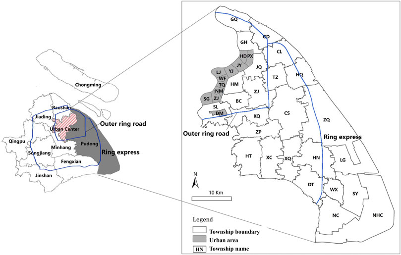
FIGURE 1. Location and township boundary in Pudong.
Pudong occupies approximately 1,392 km2 with a population of 5.52 million (PDSB, 2019), containing 36 streets (urban neighborhoods) and townships. Among them, 11 streets were fully urbanized in 2000 and had no rural settlements. Thus, there were only 25 townships that underwent rural settlements transformation from 2000 to 2018. In this study, GQ, GH, NHC, etc., are the abbreviation names of these townships in Pudong.
To reflect differentiation characteristics with urban built-up areas, this paper subdivided three rural regions of Pudong. The rural-urban fringe area, also known as the peri-urban or the urban hinterland, is the transformation zone where urban and rural uses mix and often clash; it is closest to the city center (Ma et al., 2018). Suburban area lies just outside of the rural-urban fringe, whereas exurban area is located outside of the suburban area, the furthest from the city center. Scholars divided the Shanghai metropolis into different types according to the outer ring road and the ring express (Tian et al., 2017). Based on this method, this paper classified the spatial scope of three types of areas. The urban-rural fringe area is located inside the outer ring road; the suburban area is between the outer ring road and the ring express; the exurban area is outside the ring express.
2.2 Data Sources and Pre-Processing
2.2.1 Land-Use Data From Earth Observation
Remote sensing has emerged as a compelling technology providing accurate spatial information and Land-use/Land Cover (LULC) distribution from different Earth Observation (EO) datasets in the temporal period (Rani et al., 2018; Kabisch et al., 2019). To assess different spatial characteristics of rural settlements transformation in Pudong, we obtained 2000 Landsat ETM imagery data (Landsat 7, August 03, 2000) and 2018 Landsat ETM imagery data of Pudong (Landsat 8, April 02, 2018) from the USGS website (http://landsat.usgs.gov/). We use the Random Forest Classification method and GIS spatial analysis to obtain the land-use map of 2000 and 2018 in Pudong (Van der Linden et al., 2015). Besides, we got Pudong’s 2006 land survey data from the Shanghai Urban Planning and Verifying Center (SHUPVC) and used them to adjust the classified land-use results. A 95% classification accuracy rate is achieved for the 2000 data and 97% for 2018.
2.2.2 Land-Use Data Pre-Processing
For the convenience of analysis, the land-use data in 2000 and 2018 were incorporated into the new classification system composed of six land-use types, namely agricultural land (AL), urban settlements (US), rural settlements (RS), other construction lands, such as isolated manufacturing and mining land (OC), water area (WA), unused land (UL). With the ArcGIS spatial analyst module, the land areas of each type were calculated and analyzed to assess the morphology, scale, and structural transformation of rural settlements by extracting and analyzing the land datasets in two maps (Figure 2). After converting the two LULC vector format maps into a raster format with a resolution of 10 m by 10 m (the minimum area of land covers is around 0.01 ha), this study used Fragstats 4.2 to calculate the landscape metrics to analyze the transformation of morphology.
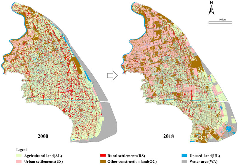
FIGURE 2. Classified land-use map of Pudong in 2000 and 2018.
2.3 Methodology
The characterization of the spatial changes in rural settlements can set up bases for exploring the transformation patterns, evolution paths, and policy recommendations (Gao et al., 2017; Gu et al., 2019; Hu et al., 2019). Generally, it is difficult to fully illustrate the entire process of the spatial variation with limited indicators because the spatial transformation of rural settlements is a complex process involving mutual conversion between rural settlements and other lands (Liu J. et al., 2014). To highlight the research focus, we use three indicators to reveal the main but not all characteristics because spatial transformation is mainly reflected in three aspects. Scale changes reveal the direction and speed of transformation, morphological changes reveal details and differences in transformation, and land-use structure changes disclose the degree of correlation between the conversion of rural settlements and other lands.
• The conversion intensity index analysis to describe the scale change.
• The conversion structure significantly index analysis to describe the land-use structure change.
• The landscape metrics analysis to reflect the morphology transformation of rural settlements patches.
Combining these methods can adequately describe rural settlements’ spatial characteristics and help understand transformation patterns and driving mechanism.
2.3.1 The Conversion Intensity Index
In literature, the land-use dynamicity model (LUDM) was explored and applied widely to quantify the magnitude of spatial change (Li T. et al., 2015). However, the conversion intensity characterized by LUDM was not comparable strictly due to the limitations of time internal. Thus, this study improved the widely used LUDM by adopting the conversion intensity index (CI) for evaluating the conversion intensity of rural settlements. The equation of CI is described as follows:
where CI denotes the average annual conversion rate at the corresponding spatial unit to ensure the spatial comparability of rural settlements conversion for different time intervals. Aa and Ab indicate the area of rural settlements at the beginning (the time a), and at the end (moment b) over the giving period, N is the time intervals.
2.3.2 The Conversion Structure Significance Index
Based on the overlay analysis in ArcGIS, this study calculated the land-use conversion structure significance index (CSS) to identify the conversion contribution ratio of land-use type
where CSS is the land-use conversion significance index for land-use type
2.3.3 The Landscape Metrics
Landscape ecological studies provide a series of quantitative metrics to study urban and rural morphology by planners, geographers, and economists (Xu, 2016). The landscape metrics (LM) can be used to describe the scale, shape, and composition of patches, which are composed of the contiguous areas of the same category. Since the purpose is to characterize the transformation of rural settlements’ morphology, the study treats all rural settlement land as a single class. Therefore, many of the fine-grained metrics, such as dispersion and contagion indices, which may be helpful at a regional scale, are not used in this research.
Some key class-level metrics are used to reflect the transformation of scale, distribution, compactness, and complexity of rural settlements morphology from the literature survey (Barry and Brian, 2013; Israel and Wynberg, 2019). The mean patch size (MPS) is the average area of rural settlements patches. It can reflect changes in the patches area. A significant value indicates that the average size of patches has increased, while a small value indicates that the average size has decreased. The patch density (PD) can describe the number of patches in a specific area. A high PD reflects the decentralized trends, while a low PD reflects the centralized trends. The landscape shape index (LSI) is a standardized measure of patch compactness; low values in this index reflect the compactness of individual patches. PARA measures the complexity of patch shape, with 1 being the index for a square-shaped patch. PARA increases without limit as the patch shape becomes more complex and irregular. The equations and descriptions of the metrics are as follows (Table 1).
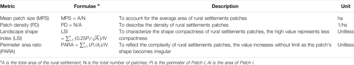
TABLE 1. Calculation formula and description of the landscape metrics.
3 Results
3.1 Spatial Distribution of Conversion Intensity Index
The results of CI showed the rural settlements’ scale decreased significantly (Figure 3). In 2000, the total area of rural settlements was 16,869.8 ha, accounting for 12.1% of the whole land. In contrast, the scale of rural settlements in 2018 was only 9,115.0 ha (6.6%). During the study period, the decreased area was relatively large, reaching 9,972.4 ha, while the increased area was relatively small, only 2,227.6 ha, resulting in a reduction of 7,754.8 ha overall.
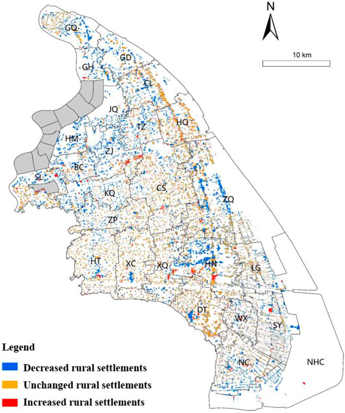
FIGURE 3. Spatial distribution of rural settlement conversions in Pudong from 2000 to 2018.
Using natural breaks (Jenks) of GIS, the CI values were classified into five categories at the township level, namely lowest intensity (0.009 < CI ≤ 0.017), low intensity (0.017 < CI ≤ 0.025), medium intensity (0.025 < CI ≤ 0.030), high intensity (0.030 < CI ≤ 0.041), highest intensity (0.041 < CI ≤ 0.055) (Table 2). The results indicated that the CI had significant differentiation. There were four highest intensity townships, comprising 23.6% of the total reduction area, six high intensity townships (10.1%), and six medium intensity townships (40.8%). The low and lowest intensity townships were five and four, respectively, accounting for 14.6 and 10.9% of the total reduction area.
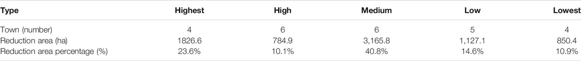
TABLE 2. Reduction of rural settlement areas among towns in Pudong.
The spatial distribution of CI indicated the reduction area of rural settlements decreased from the highest level in urban-fringe areas to the lowest level in the exurban areas (Figure 4). Differences in the spatial location between rural settlements and urban areas can explain spatial differentiation. Most of the highest intensity townships were concentrated in the north center, with only one township (NHC) located in the south. Because it was a new township receiving priority development support from the Shanghai municipality government, a lot of development and construction in this township resulted in the rapid reduction of its rural settlements. The high intensity townships were located near the north center. The rapid expansion of urban led to the quick erosion of rural settlements closer to them. The medium intensity townships were scattered in the middle of Pudong. As the rural settlements in these townships were far away from the city center, they were affected less by urban encroachment. The low and lowest intensity townships were concentrated in the south. These townships were the traditional agricultural area, and they were affected less by urbanization and industrialization.
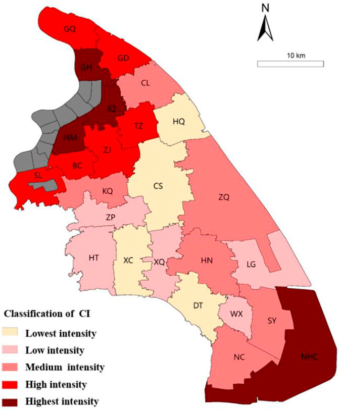
FIGURE 4. CI of rural settlements at the township level in Pudong from 2000 to 2018.
3.2 Spatial Differentiation of Conversion Structure Significance Index
3.2.1 Overall Conversion Structure
Table 3 showed that the scale of rural settlements converting to other land-use types was more than that of rural settlements converting from other land-use types, so the rural settlements’ scale sharply decreased by 7,754.8 ha. The total area ratio of urban settlements, other construction lands, agricultural land, and water area converting from the rural settlement is 8:5:2:1, which fits the changing pace of rural settlements. It showed that the transformation of rural settlements is coordinated and integrated with urbanization and agricultural modernization in the metropolis. This phenomenon is unique in China and is generally observed in the other study areas out of the metropolis (Li T. et al., 2015; Shi et al., 2016).
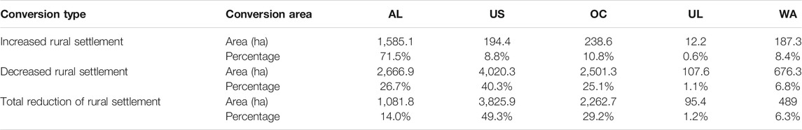
TABLE 3. Conversion structure between rural settlement and other land-use types in 2000 and 2018.
The majority of increased rural settlements came from agricultural land (71.5%), while the majority of the decreased rural settlements converted into urban settlements and other construction lands, accounting for 40.3 and 25.1%, respectively. As the distance from rural settlements to urban areas increased, this proportion of the converted regions from rural settlements decreased. A small amount of rural settlements has been converted into agricultural land, water, and unused land, which improved the rural environment. These results showed that rural settlements transformation of these areas was significantly influenced by planning policies.
3.2.2 Conversion Structure Significance Index at the Township Level
The spatial distribution of CSS at the township level showed that the land-use conversion of rural settlements varied a lot in the urban-rural fringe area, suburban area, and the exurban area (Figure 5). The CSS of rural settlements in the urban-rural fringe area was high in urban settlements and other construction land but low in agricultural land. It indicated that rural settlements were mainly converted into construction land. Driving by rapid urbanization, the peripheral towns were preferred to provide more space for the rapid expansion of economic activities because of their location advantage. Therefore, rural settlements in this area are mainly converted into urban settlements and other construction lands.
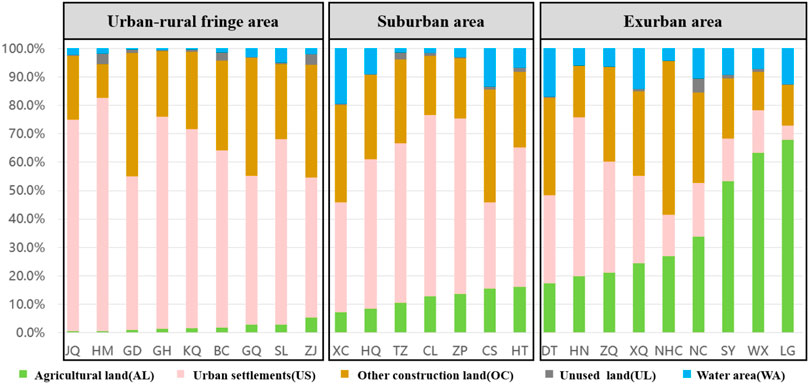
FIGURE 5. Spatial distribution of CSS at the township level in Pudong from 2000 to 2018.
In contrast, the value of CSS in the exurban area was high in agricultural land but very low in urban settlements and other construction lands. It indicated that most rural settlements were converted into agricultural land. Constrained by the physical geographical location and economic condition, the general socio-economic status of these areas has undergone a significant downturn. Rural settlements in this area mainly undertook the living and production functions. Besides, these areas were the primary agricultural area of Pudong, in which the protection of cultivated land policy was applied tightly. Under these situations, the proportion of agricultural land increased with a relatively higher CSS value. In addition, the CSS of rural settlements in the suburban area was different. Neither of the land-use types had a higher CSS value. In other words, the land-use type structure converting from rural settlements was more balanced, with a relatively diverse conversion structure of rural settlements.
3.3 Dynamics Change of Landscape Metrics
The differentiation of LM values indicated that the average area of rural settlements patches became larger, the spatial distribution became more concentrated, the shape became more regular (Table 4). The MPS of rural settlements showed a significant increase from 2.31 to 3.86. It demonstrated that there were merger activities of rural settlements under government policies. Meanwhile, a rapid decrease in the PD from 43.13 to 25.86 indicated that the concentration of rural settlements gradually aggravated. In other words, the rural settlements were becoming more clustered. Besides, the LSI decreased slightly from 1.69 to 1.66, illustrating that the shape compactness of rural settlements kept stable. However, the PARA has dropped significantly from 1,039.36 to 556.96, by 46.4%. The variation of PARA showed that the shape of rural settlements became regular as being more affected by human activities.

TABLE 4. Landscape metrics change of rural settlements in Pudong in 2000 and 2018.
As Figure 6 shows, the changes in these four metrics at the township level were asynchronous because of the differences in the conversion intensity and structure. A huge gap existed in the shift of MPS in different townships. In 2000, the largest and the lowest value of MPS was 3.8 and 1.5 ha, respectively. The corresponding MPS increased to 9.4 and 1.9 ha in 2018, separately. They represented the largest and smallest concentration of rural settlements. We can also find that MPS in some exurban areas increased by 2–3 times. They are much larger than that of the urban fringe areas. It indicated that the rural settlements in the exurban area experienced a consolidation process. There was a significant decrease in the variation of PD, indicating that the density of rural settlements decreased and became more concentrated.
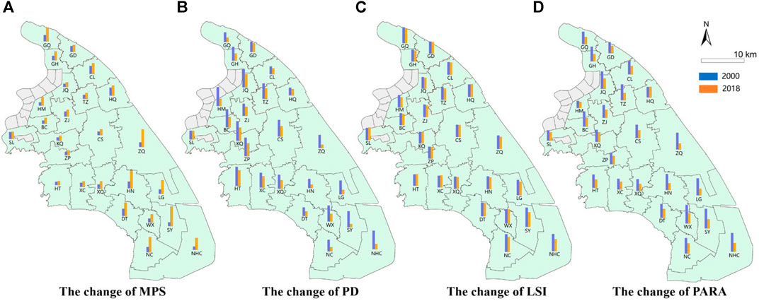
FIGURE 6. The change of LM at the township level from 2000 to 2018.
The LSI of these townships dropped wholly during the study period, indicating that the morphology of rural settlements became compact. Among these townships, the LSI of the southern townships, notably LG, NC, NHC, SY, and WX, was higher than the other townships, illustrating the morphology of rural settlements in the southern townships was flabbier. The PARA of rural settlements in all townships has decreased by nearly 50%, which has turned to regular and straightforward shapes. Besides, the gap of PARA in the different townships became smaller, indicating the morphology differences in various townships disappeared. The variation of PARA also reflected that the impact of human activities on the rural settlements strengthened gradually and the decreased effects of natural attributes on rural settlements.
3.4 Transformation Patterns
Based on the spatial differentiation characteristics of CI, CSS, and LM at the township level, this study used the cluster analysis method in SPSS to classify three patterns for understanding the driving forces and transformation mechanism, namely the rapid disappearance pattern, the orderly transformation pattern, and the physical decay pattern. The indicator intervals of CI, CSS, and LM of three types are shown in Table 5. Figure 7 shows the spatial distribution of three types.
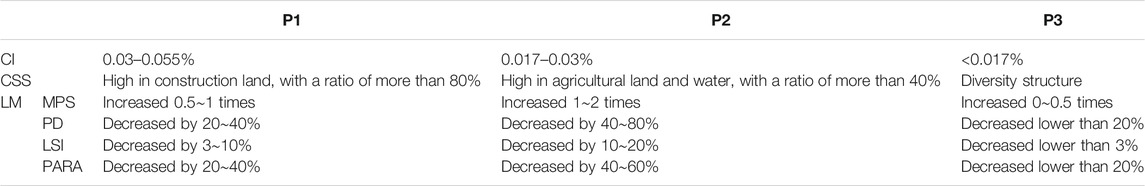
TABLE 5. The indicator intervals of three type areas.
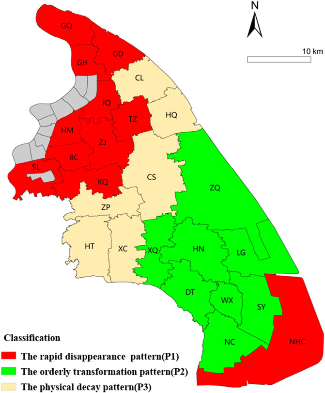
FIGURE 7. Spatial differentiation of rural settlements transformation patterns.
3.4.1 The Rapid Disappearance Pattern
The rapid disappearance pattern (P1) has three significant characteristics. In terms of CI, the value of P1 was between 0.03 and 0.055%. It was much higher than the other two patterns, both of which were under 0.03%. Also, the CSS value of this pattern was very high in urban settlements and other construction lands, indicating that most decreased rural settlements were converted into urban construction land. Furthermore, the change magnitude of each LM was modest, just between P2 and P3. This pattern of rural settlements is mainly located in the urban-fringe area, including GQ, GH, GD, JQ, TZ, ZJ, HM, KQ, BC, SL. As mentioned above, although the NHC township was in Pudong’s exurban, it still underwent a rapid disappearance of rural settlements because it was a strategic new town receiving priority construction by the Shanghai government. Therefore, the transformation pattern of the NHC township belonged to the P1 pattern.
3.4.2 The Orderly Transformation Pattern
The orderly transformation pattern (P2) has its unique characteristics. In terms of CI, the value of P2 ranged between 0.017 and 0.03%. It was lower than P1 but higher than P3. In addition, the CSS value of this pattern was very high in agricultural land and water area, indicating that this pattern had improved the environment effectively. However, there was a significant change in each LM. Its value was much higher than that of P1 and P3. The MPS of this pattern increased almost 1∼2 times, while the PARA decreased by 40–60%, reflecting the spatial structure and land-use efficiency were optimized. Compared to P1, this pattern of rural settlements was mainly located in the exurban area, the primary agricultural base in Pudong. Some townships like XQ, HN, LG, DT, WX, SY, ZQ, NC belonged to this pattern.
3.4.3 The Physical Decay Pattern
On the whole, the physical decay pattern (P3) changed very slowly. In terms of CI, the value of P3 was the lowest among the three categories, with a value under 0.017%. The CSS value of P1 and P2 were high in urban settlements and agricultural land, respectively, which was also found in the previous study (Li Y. et al., 2015; Ma et al., 2018). However, compared to them, the CSS value of P3 had a balanced distribution among urban settlements, other construction lands, agricultural land, and water area. In other words, the transformation was more diverse, and no land-use type converting from the rural settlements was dominant in this pattern. Furthermore, the change magnitude of LM in this pattern didn’t have a significant change, which formed a sharp contrast with P2. This pattern of rural settlements is mainly located in suburban areas. Some townships like HQ, CS, ZQ, ZP, HT belonged to this pattern.
4 Discussion
4.1 Driving Mechanism of Rural Settlement Transformation
The spatial changes of rural settlements in CI, CSS, and LM, are the combined effect of multiple factors, including urban encroachment, planning policies, fundamental conditions (Shi et al., 2016; Xu et al., 2018). However, the main driving factors and their mechanisms with different transformation patterns are unequal, resulting in the spatial differentiation of rural settlements in the metropolis. The driving mechanism of these patterns is analyzed in Figure 8.
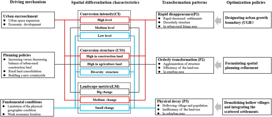
FIGURE 8. The space differentiation characteristics, driving mechanism, and optimization policies of rural settlements transformation patterns.
4.1.1 Urban Encroachment
Urban encroachment was the direct force resulting in the decreased rural settlements area of P1 over the study time, and the results are consistent with the previous study (Liu J. et al., 2014; Ma et al., 2018). Shanghai municipality government confirmed the positioning of Pudong as the city business center. These regional development strategies promoted urbanization and industrialization of Pudong, which inevitably led to Pudong obtaining enough construction land for urban industry and human activities. Therefore, the rural settlements near the urban construction boundary, especially in urban-rural fringe areas, became the first choice occupied by urban settlements. Thus, the rural settlements gradually moved away from the urban construction boundary, resulting in the rapid conversion into urban settlements. There was a clear correlation between disappearance in the total area of rural settlements and their distances to the urban construction boundary over the study time range for this pattern. Rural settlements close to the urban construction boundary in the scope of 1,000 m exhibited the most pronounced disappearance speed, illustrating the urban encroachment on the rural territory was more significant in the urban-fringe area than suburban and exurban areas.
However, unlike previous studies, we found that the main driving factor of one township (NHC) in the exurban area was also urban expansion. As this town was designated as a critical development town by the Shanghai municipality government, the urban encroachment on rural settlements in this township was rapid.
4.1.2 Planning Policies
A series of planning policies played an essential role in reshaping the rural settlements of P2. This effect was evident in exurban areas where the authorities implemented a series of planning policies, pushing rural settlements’ scale and morphology to be more efficient and compact. These results can also be found in the previous study (Kan, 2016; Lo et al., 2016; Han and Lin, 2019). These policies include increasing versus decreasing the balance of urban-rural construction land, rural land consolidation, building a new countryside, etc. Overall, rural settlements of P2 showed a “men-environment” compatible transformation pattern by a series of planning policies. The driving mechanisms of these planning policies are as follows.
First, the scale of rural settlements was optimized by the increasing versus decreasing balance of urban-rural construction land. This policy guided the structural and quantitative allocation of land between the urban and rural areas, requiring that cultivated land area reclaimed from rural settlements should be equal to the increased size of urban settlements. Thus, the rural settlements of P2 decreased and converted into agricultural land. These policies directly optimized the scale of rural settlements. Second, the distribution of rural settlements was adjusted by rural land consolidation. This policy reclaimed hollow rural settlements and converted them into agricultural land; the surplus construction land index can build new rural communities and construct modern agriculture landscapes. It enhanced the land-use efficiency and then generated the spatial agglomeration effects by adjusting the scattered and extensive rural settlements. Third, the morphology of rural settlements was regulated by building a new countryside. This policy guided and promoted rural settlements development by utilizing the land intensively and efficiently. Driving by these policies, rural settlements in P2 changed from disorderly spatial expansion to orderly development.
4.1.3 Fundamental Conditions
The fundamental conditions, including the limitation of the physical geographic condition and weak economic location, were the main driving factors of P3. Compared with the other two categories, this pattern was often located in the traditional rural hinterland with less favored physical conditions and weak socio-economic foundations. Neither urban encroachment nor planning policies are the main driving factors in suburban areas. Constrained by economic location, rural settlements became the principal living place for villagers in agricultural production. However, the modernization of agriculture reduced the number of agricultural employees. Also, there were many employment opportunities in the urban area. Villagers in the rural area were more attracted to migrate into the city for a high-salary job than being engaged in agriculture production activities. Therefore, the transfer of population from rural areas generated the hollowing-out of the agricultural community, which exacerbated the hollowing-out of rural industries. Finally, this vicious circle resulting from the limitation of the physical geographic condition and economic location formed the rural settlements of P3 in Pudong.
Overall, three basic patterns were formed by different influence factors. Among them, the effect of urban encroachment was the most significant, causing rural settlements in the urban-fringe area to decrease sharply. The influence of planning policies was huge in reshaping and optimizing the scale and morphology of rural settlements in the exurban area. The impact of natural background conditions and economic location still existed; it played an important role in population transfer between urban-rural regions, resulting in the physical decay pattern in suburban areas. Therefore, different driving factors intensified the spatial differentiation of rural settlements transformation within the metropolis.
4.2 The Difference of Rural Settlements Transformation Between China and Western Countries
Both China and Western countries have undergone rural settlements transformation resulting from the flow of population, land, and resource elements. However, there are also some differences between them. First, the dynamics of transformation are different. Rural settlements transformation in China is mainly induced by rapid urbanization and industrialization. It resulted in population, land, and resources flowing from rural areas to cities (Chan, 2010). Its essence is the rural decline caused by the rapid loss of rural elements. Western countries have finished industrialization, urbanization, and agricultural modernization. Post-industrialization and counter-urbanization are the main drivers, which promote capital inflow from cities to rural areas, making the countryside the second home for urban residents. Its essence is the spatial reorganization of rural elements embedded by urban elements.
Second, the methods of transformation are different. China has a dominating top-down policy-making process compared to vital bottom-up processes in western countries. Government agencies at different levels in China control the policy-making of rural development, which formed a state-led urban-rural transformation process (Wang, 2018). Decollectivization of agriculture, hukou reforms, and relaxation of migration controls have resulted in rural villagers coming to the cities to sell their labor at meager wages. Villagers’ needs are ignored in this top-down process. In contrast, local villagers and other stakeholders in many western countries can deep participate in the rural transformation processes with designers as facilitators. The bottom-up rural transformation process is highly unified with the needs of the local villagers (Primdahl and Kristensen, 2016).
Third, the basis of transformation is different. Land ownership in China is fundamentally different from most developed nations. Land in western countries is almost privately owned, which can be offered freehold. China’s land is collectively owned in rural areas and nationally owned in urban areas, both of which can only be offered on a leasehold system. According to the China Land Management Law (1988), all land usage rights can be leased for a fixed period based on different land types. The government strictly restricted the conversion of farmland to non-agricultural and the transaction of the homestead by farmers. In other words, rural land circulation in western countries is free, while that in China is subject to more significant land policy constraints.
4.3 Policy Recommendations
The spatial differentiation of rural settlements transformation in Pudong proceeded under the combined effects of multiple factors, and the driving factor of each pattern is different. Hence, we can adequately guide the transformation direction of rural settlements by adjusting the driving factors that affect their variation. The optimization policy for each pattern is explored as follows. First, it is recommended to strictly control the spatial expansion of urban settlements through an urban growth boundary (UGB). In the past, urban encroachment has swallowed too many rural settlements and cultivated land due to a lack of control over urban development boundaries and scale (Tian et al., 2014; Gao et al., 2017). UGB should be implemented to control urban settlements at a reasonable size and improve the spatial structure of urban-rural. Thus, urban encroachment can be converted from the excessive expansion form to an appropriate growth form. Ultimately, the rapid and unreasonable decrease in rural settlements of P1 can be prevented.
Furthermore, spatial planning should be formulated scientifically to protect settlements’ morphology characteristics and inherit rural style so that the diversity and orderly development in rural settlements of P2 can be continued. On the one hand, the red lines on construction space, agricultural space, and ecology space should be drawn scientifically to control the scale distribution of different land-use types wisely. The spatial planning should respect natural conditions and the various spatial requirements encouraged by urbanization, agriculture modernization, and environmental protection to realize sustainable rural development. On the other hand, a series of rural reconstruction projects, such as the layout of new villages and the construction of rural residential, should consider and inherit the morphology characteristics of rural settlements. Rural settlements’ morphology characteristics are an excellent interactive result of natural conditions and social, economic development, so it is necessary to avoid copying urban planning methods to rural planning directly.
Finally, the spatial structure and layout of rural settlements should be improved by demolishing hollow villages and integrating the scattered settlements to promote the development of the rural settlements of P3. The rural settlements with a larger scale and better economic foundation should be retained and guided by proper planning and layouts. They can be the central village serving the surrounding communities. For rural settlements with high idle construction land resulting from a large amount of rural population outflow, its scale should be gradually reduced. By combining the use of idle land with the spatial needs of new rural industries, the scale reduction and structural optimization of rural settlements of P3 can be realized.
4.4 Limitation and Future Research
There are still some limitations in this study. Due to the limited data available in the study area, this paper mainly explores the transformation of rural settlements from a spatial perspective. It cannot comprehensively reflect the shift of the socio-economic condition of rural settlements and the impact of technological progress on the rural settlements, such as mobility modes. Since rural settlements transformation is closely linked to the local rural environment and the socio-economic process (Li D. et al., 2016; Yanbo et al., 2018), a field survey is needed to get primary data of industries, facilities, and population information in future research. In addition, the temporal sampling in this research is minimal with only 2 years (2000 and 2018), ignoring the non-linear variability between the period. Future research needs to add more temporal sampling data to help reveal the detailed process of transformation. Moreover, the connotation of spatial transformation is very rich and diverse. The three types of indicators constructed in this research can only reveal the main spatial differentiation characteristics but cannot fully display all the characteristics. More indicators are needed in future research to appreciate the full spatial complexity of rural settlements transformation. Finally, this study analyzes driving factors and mechanisms with a qualitative method, so it can not accurately explain the extent of the driving factors that influence the transformation characteristic. Thus, a quantitative analysis of driving factors is required in future research.
5 Conclusion
Due to a vast geographic space and multi factors, there is an enormous spatial differentiation of rural settlements transformation in the metropolis of developing countries. Figuring out the differentiation characteristics can help build more effective spatial optimization policies. This paper applied CI, CSS, and LM to explore the spatial differentiation characteristics and reveal the driving mechanism of rural settlements in the metropolis at the township level. The main conclusions we draw are as follows.
First, the spatial differentiation of rural settlements transformation within the metropolis is huge. The results of CI indicate a significant decrease in settlements’ size, and the values decreased from urban-rural fringe to exurban area. Most decreased rural settlement land was converted into urban settlements, and the CSS values varied a lot in different areas. The results of LM indicate the settlements’ morphology became more compact and regular, but to a varying degree in different regions.
Second, based on spatial differentiation characteristics, three patterns were classified. The rapid disappearance pattern was mainly located in the urban-rural fringe area, and its scale converted into urban settlements quickly. The physical decay pattern was primarily located in the suburban area, its scale decreased slowly, and the conversion structure became more diverse. The orderly transformation pattern was mainly located in the exurban area, its scale fell with a medium speed, and the patches’ morphology became more regular.
Third, the main driving factors of different patterns are unequal, resulting in the spatial differentiation of rural settlements within the metropolis. The rapid disappearance pattern, the physical decay pattern, and the orderly transformation pattern were mainly caused by urban encroachment, limitation of geographic conditions, and planning policies separately.
This study reveals the spatial differentiation characteristics of rural settlements transformation within the metropolis at the township level, rather than merely treating it as a whole area. It enriches research content by providing an empirical study of a typical area in the metropolis of developing countries. Besides, the classification of transformation patterns and identification of driving factors can provide scientific guidance for optimizing rural settlements.
Data Availability Statement
The original contributions presented in the study are included in the article/supplementary material, further inquiries can be directed to the corresponding author.
Author Contributions
KL and HG initiated this study with an original idea, conducted the overall analysis, and wrote this article. LY suggested appropriate methodologies for the global study. KL and LH provided help for data collection and data analyses. All authors have conducted data processing and other related work.
Acknowledgments
This research was funded by the National Natural Science Foundation of China (grant 71841002), and China Scholarship Council (grant 201806260232). We appreciate greatly the constructive comments and suggestions from reviewers.
Conflict of Interest
The authors declare that the research was conducted in the absence of any commercial or financial relationships that could be construed as a potential conflict of interest.
Publisher’s Note
All claims expressed in this article are solely those of the authors and do not necessarily represent those of their affiliated organizations, or those of the publisher, the editors, and the reviewers. Any product that may be evaluated in this article or claim that may be made by its manufacturer is not guaranteed or endorsed by the publisher.
References
Barrett, B. F. D. (1999). Environmentalism in Periods of Rapid Societal Transformation: the Legacy of the Industrial Revolution in the United Kingdom and the Meiji Restoration in Japan. Sust. Dev. 7 (4), 178–190. doi:10.1002/(sici)1099-1719(199911)7:4<178::aid-sd113>3.0.co;2-l
Barry, K., and Brian, L. (2013). Measuring Sprawl across the Urban Rural Continuum Using an Amalgamated Sprawl Index. Sustainability 5, 1806–1828. doi:10.3390/su5051806
Bibby, P. (2009). Land Use Change in Britain. Land Use Policy 26, S2–S13. doi:10.1016/j.landusepol.2009.09.019
Cattaneo, C., and Gavaldà, M. (2010). The Experience of Rurban Squats in Collserola, Barcelona: what Kind of Degrowth? J. Clean. Prod. 18 (6), 581–589. doi:10.1016/j.jclepro.2010.01.010
Chan, K. W. (2010). Fundamentals of China's Urbanization and Policy. China Rev., 63–93. https://www.jstor.org/stable/23462243.
Chen, C., Gao, J., and Chen, J. (2017). Institutional Changes, Land Use Dynamics, and the Transition of Rural Settlements in Suburban China: A Case Study of Huishan District in Wuxi City. Habitat Int. 70, 24–33. doi:10.1016/j.habitatint.2017.09.011
Gao, X., Xu, A., Liu, L., Deng, O., Zeng, M., Ling, J., et al. (2017). Understanding Rural Housing Abandonment in China's Rapid Urbanization. Habitat Int. 67, 13–21. doi:10.1016/j.habitatint.2017.06.009
Gu, X., Xie, B., Zhang, Z., and Guo, H. (2019). Rural Multifunction in Shanghai Suburbs: Evaluation and Spatial Characteristics Based on Villages. Habitat Int. 92, 102041. doi:10.1016/j.habitatint.2019.102041
Han, S. S., and Lin, W. (2019). Transforming Rural Housing Land to farmland in Chongqing, China: The Land Coupon Approach and Farmers' Complaints. Land Use Policy 83, 370–378. doi:10.1016/j.landusepol.2019.02.001
Hu, X., Li, H., Zhang, X., Chen, X., and Yuan, Y. (2019). Multi-dimensionality and the Totality of Rural Spatial Restructuring from the Perspective of the Rural Space System: A Case Study of Traditional Villages in the Ancient Huizhou Region, China. Habitat Int. 94, 102062. doi:10.1016/j.habitatint.2019.102062
Israel, A., and Wynberg, R. (2019). Multifunctional Landscapes in a Rural, Developing Country Context: Conflicts and Synergies in Tshidzivhe, South Africa. Landscape Res. 44 (4), 404–417. doi:10.1080/01426397.2018.1441388
Jamshed, A., Birkmann, J., Rana, I. A., and McMillan, J. M. (2020). The Relevance of City Size to the Vulnerability of Surrounding Rural Areas: An Empirical Study of Flooding in Pakistan. Int. J. Disaster Risk Reduction 48, 101601. doi:10.1016/j.ijdrr.2020.101601
Jia, K., Qiao, W., Chai, Y., Feng, T., Wang, Y., and Ge, D. (2020). Spatial Distribution Characteristics of Rural Settlements under Diversified Rural Production Functions: A Case of Taizhou, China. Habitat Int. 102, 102201. doi:10.1016/j.habitatint.2020.102201
Jiang, G., He, X., Qu, Y., Zhang, R., and Meng, Y. (2016a). Functional Evolution of Rural Housing Land: A Comparative Analysis across Four Typical Areas Representing Different Stages of Industrialization in China. Land Use Policy 57, 645–654. doi:10.1016/j.landusepol.2016.06.037
Jiang, W., Deng, Y., Tang, Z., Cao, R., Chen, Z., and Jia, K. (2016b). Adaptive Capacity of Mountainous Rural Communities under Restructuring to Geological Disasters: The Case of Yunnan Province. J. Rural Stud. 47, 622–629. doi:10.1016/j.jrurstud.2016.05.002
Kabisch, N., Selsam, P., Kirsten, T., Lausch, A., and Bumberger, J. (2019). A Multi-Sensor and Multi-Temporal Remote Sensing Approach to Detect Land Cover Change Dynamics in Heterogeneous Urban Landscapes. Ecol. indicators 99, 273–282. doi:10.1016/j.ecolind.2018.12.033
Kan, K. (2016). The Transformation of the Village Collective in Urbanising China: A Historical Institutional Analysis. J. Rural Stud. 47, 588–600. doi:10.1016/j.jrurstud.2016.07.016
Kohler, F., Marchand, G., and Negrão, M. (2015). Local History and Landscape Dynamics: A Comparative Study in Rural Brazil and Rural France. Land Use Policy 43, 149–160. doi:10.1016/j.landusepol.2014.11.010
Li, D., Wang, D., Li, H., Zhang, S., Zhang, X., and Tao, Y. (2016a). The Effects of Urban Sprawl on the Spatial Evolution of Rural Settlements: A Case Study in Changchun, China. Sustainability 8 (8), 736. doi:10.3390/su8080736
Li, G., Jiang, G., Jiang, C., and Bai, J. (2018a). Differentiation of Spatial Morphology of Rural Settlements from an Ethnic Cultural Perspective on the Northeast Tibetan Plateau, China. Habitat Int. 79, 1–9. doi:10.1016/j.habitatint.2018.06.002
Li, H., Yuan, Y., Zhang, X., Li, Z., Wang, Y., and Hu, X. (2019). Evolution and Transformation Mechanism of the Spatial Structure of Rural Settlements from the Perspective of Long-Term Economic and Social Change: A Case Study of the Sunan Region, China. J. Rural Stud. doi:10.1016/j.jrurstud.2019.03.005
Li, J., Qiu, R., Li, K., and Xu, W. (2018b). Informal Land Development on the Urban Fringe. Sustainability 10 (2), 128. doi:10.3390/su10010128
Li, T., Long, H., Liu, Y., and Tu, S. (2015a). Multi-scale Analysis of Rural Housing Land Transition under China's Rapid Urbanization: The Case of Bohai Rim. Habitat Int. 48, 227–238. doi:10.1016/j.habitatint.2015.04.002
Li, X., Li, H., Zhang, Y., and Yang, L. (2017). Spatial Patterns and the Regional Differences of Rural Settlements in Jilin Province, China. Sustainability 9 (12), 2170. doi:10.3390/su9122170
Li, Y., Li, Y., Westlund, H., and Liu, Y. (2015b). Urban-rural Transformation in Relation to Cultivated Land Conversion in China: Implications for Optimizing Land Use and Balanced Regional Development. Land Use Policy 47, 218–224. doi:10.1016/j.landusepol.2015.04.011
Li, Y., Westlund, H., Zheng, X., and Liu, Y. (2016b). Bottom-up Initiatives and Revival in the Face of Rural Decline: Case Studies from China and Sweden. J. Rural Stud. 47, 506–513. doi:10.1016/j.jrurstud.2016.07.004
Lin, L., and Shen, J. (2018). Spatial Patterns and Driving Forces of Uneven Dual-Track Urbanisation in Fujian Province: An Approach Based on Employment Sectors. Urban Stud. 56 (12), 2568–2584. doi:10.1177/0042098018798596
Liu, J., Kuang, W., Zhang, Z., Xu, X., Qin, Y., Ning, J., et al. (2014a). Spatiotemporal Characteristics, Patterns, and Causes of Land-Use Changes in China since the Late 1980s. J. Geogr. Sci. 24 (2), 195–210. doi:10.1007/s11442-014-1082-6
Liu, J., Liu, Y., and Yan, M. (2016). Spatial and Temporal Change in Urban-Rural Land Use Transformation at Village Scale-A Case Study of Xuanhua District, North China. J. Rural Stud. 47, 425–434. doi:10.1016/j.jrurstud.2016.07.003
Liu, S., and Wang, Y. (2018). From Native Rural china to Urban-Rural China: The Rural Transition Perspective of China Transformation. Manag. World 128, 128-146. doi:10.19744/j.cnki.11-1235/f.2018.10.012
Liu, W., Yang, C., Liu, Y., Wei, C., and Yang, X. (2018). Impacts of Concentrated Rural Resettlement Policy on Rural Restructuring in upland Areas: A Case Study of Qiantang Town in Chongqing, China. Land Use Policy 77, 732–744. doi:10.1016/j.landusepol.2018.06.011
Liu, Y., Luo, T., Liu, Z., Kong, X., Li, J., and Tan, R. (2015). A Comparative Analysis of Urban and Rural Construction Land Use Change and Driving Forces: Implications for Urban-Rural Coordination Development in Wuhan, Central China. Habitat Int. 47, 113–125. doi:10.1016/j.habitatint.2015.01.012
Liu, Y., Yang, R., Long, H., Gao, J., and Wang, J. (2014b). Implications of Land-Use Change in Rural China: A Case Study of Yucheng, Shandong Province. Land Use Policy 40, 111–118. doi:10.1016/j.landusepol.2013.03.012
Liu, Y., Yang, Y., Li, Y., and Li, J. (2017). Conversion from Rural Settlements and Arable Land under Rapid Urbanization in Beijing during 1985-2010. J. Rural Stud. 51, 141–150. doi:10.1016/j.jrurstud.2017.02.008
Lo, K., Xue, L., and Wang, M. (2016). Spatial Restructuring through Poverty Alleviation Resettlement in Rural China. J. Rural Stud. 47, 496–505. doi:10.1016/j.jrurstud.2016.06.006
Long, H. (2014). Land Consolidation: An Indispensable Way of Spatial Restructuring in Rural China. J. Geogr. Sci. 24 (2), 211–225. doi:10.1007/s11442-014-1083-5
Long, H., Li, Y., Liu, Y., Woods, M., and Zou, J. (2012). Accelerated Restructuring in Rural China Fueled by 'increasing vs. Decreasing Balance' Land-Use Policy for Dealing with Hollowed Villages. Land Use Policy 29 (1), 11–22. doi:10.1016/j.landusepol.2011.04.003
Long, H., Liu, Y., Li, X., and Chen, Y. (2010). Building New Countryside in China: A Geographical Perspective. Land Use Policy 27 (2), 457–470. doi:10.1016/j.landusepol.2009.06.006
Long, H., and Liu, Y. (2016). Rural Restructuring in China. J. Rural Stud. 47, 387–391. doi:10.1016/j.jrurstud.2016.07.028
Luo, W., and Timothy, D. J. (2017). An Assessment of Farmers' Satisfaction with Land Consolidation Performance in China. Land Use Policy 61, 501–510. doi:10.1016/j.landusepol.2016.12.002
Ma, W., Jiang, G., Li, W., Zhou, T., and Zhang, R. (2019). Multifunctionality Assessment of the Land Use System in Rural Residential Areas: Confronting Land Use Supply with Rural Sustainability Demand. J. Environ. Manage. 231, 73–85. doi:10.1016/j.jenvman.2018.09.053
Ma, W., Jiang, G., Wang, D., Li, W., Guo, H., and Zheng, Q. (2018). Rural Settlements Transition (RST) in a Suburban Area of metropolis: Internal Structure Perspectives. Sci. Total Environ. 615, 672–680. doi:10.1016/j.scitotenv.2017.09.152
McCarthy, J. (2008). Rural Geography: Globalizing the Countryside. Prog. Hum. Geogr. 32 (1), 129–137. doi:10.1177/0309132507082559
Nilsson, K., Nielsen, T. S., Aalbers, C., Bell, S., Boitier, B., Chery, J. P., et al. (2014). Strategies for Sustainable Urban Development and Urban-Rural Linkages. Eur. J. Spat. Dev., 25. https://hal.archives-ouvertes.fr/hal-01528698.
Ottomano Palmisano, G., Govindan, K., Boggia, A., Loisi, R. V., De Boni, A., and Roma, R. (2016). Local Action Groups and Rural Sustainable Development. A Spatial Multiple Criteria Approach for Efficient Territorial Planning. Land Use Policy 59, 12–26. doi:10.1016/j.landusepol.2016.08.002
Primdahl, J., and Kristensen, L. S. (2016). Landscape Strategy Making and Landscape Characterisation-Experiences from Danish Experimental Planning Processes. Landscape Res. 41 (2), 227–238. doi:10.1080/01426397.2015.1135322
Qu, Y., Jiang, G.-h., Li, Z., Tian, Y., and Wei, S. (2019). Understanding Rural Land Use Transition and Regional Consolidation Implications in China. Land Use Policy 82, 742–753. doi:10.1016/j.landusepol.2018.11.014
Rani, M., Kumar, P., Pandey, P. C., Srivastava, P. K., Chaudhary, B. S., Tomar, V., et al. (2018). Multi-temporal NDVI and Surface Temperature Analysis for Urban Heat Island Inbuilt Surrounding of Sub-humid Region: A Case Study of Two Geographical Regions. Remote Sensing Appl. Soc. Environ. 10, 163–172. doi:10.1016/j.rsase.2018.03.007
Shen, M., and Shen, J. (2017). Governing the Countryside through State-Led Programmes: A Case Study of Jiangning District in Nanjing, China. Urban Stud. 55 (7), 1439–1459. doi:10.1177/0042098017716857
Shi, M., Xie, Y., and Cao, Q. (2016). Spatiotemporal Changes in Rural Settlement Land and Rural Population in the Middle Basin of the Heihe River, China. Sustainability 8 (7), 614. doi:10.3390/su8070614
Song, L. (2019). Expansion of Rural Settlements on High-Quality Arable Land in Tongzhou District in Beijing, China. Sustainability 11 (19), 5153. doi:10.3390/su11195153
Song, W., and Li, H. (2020). Spatial Pattern Evolution of Rural Settlements from 1961 to 2030 in Tongzhou District, China. Land Use Policy 99, 105044. doi:10.1016/j.landusepol.2020.105044
Sonn, J. W., and Gimm, D.-W. (2013). South Korea's Saemaul (New Village) Movement: an Organisational Technology for the Production of Developmentalist Subjects. Can. J. Dev. Studies/Revue canadienne d'études du développement 34 (1), 22–36. doi:10.1080/02255189.2013.755921
Tian, C., and Fang, L. (2018). The Impossible in China's Homestead Management: Free Access, Marketization and Settlement Containment. Sustainability 10 (3), 798. doi:10.3390/su10030798
Tian, G., Qiao, Z., and Gao, X. (2014). Rural Settlement Land Dynamic Modes and Policy Implications in Beijing Metropolitan Region, China. Habitat Int. 44, 237–246. doi:10.1016/j.habitatint.2014.06.010
Tian, L., Li, Y., Yan, Y., and Wang, B. (2017). Measuring Urban Sprawl and Exploring the Role Planning Plays: A Shanghai Case Study. Land Use Policy 67, 426–435. doi:10.1016/j.landusepol.2017.06.002
Tu, S., Long, H., Zhang, Y., Ge, D., and Qu, Y. (2018). Rural Restructuring at Village Level under Rapid Urbanization in Metropolitan Suburbs of China and its Implications for Innovations in Land Use Policy. Habitat Int. 77, 143–152. doi:10.1016/j.habitatint.2017.12.001
Van der Linden, S., Rabe, A., Held, M., Jakimow, B., Leitão, P., Okujeni, A., et al. (2015). The EnMAP-Box-A Toolbox and Application Programming Interface for EnMAP Data Processing. Remote Sensing 7 (9), 11249–11266. doi:10.3390/rs70911249
Votsis, A., and Haavisto, R. (2019). Urban DNA and Sustainable Cities: A Multi-City Comparison. Front. Environ. Sci. 7, 4. doi:10.3389/fenvs.2019.00004
Wang, C., Liu, Y., Kong, X., and Li, J. (2017). Spatiotemporal Decoupling between Population and Construction Land in Urban and Rural Hubei Province. Sustainability 9 (7), 1258. doi:10.3390/su9071258
Wang, Z. (2018). Evolving Landscape-Urbanization Relationships in Contemporary China. Landscape Urban Plann. 171, 30–41. doi:10.1016/j.landurbplan.2017.11.010
Wilson, G. A. (2009). The Spatiality of Multifunctional Agriculture: A Human Geography Perspective. Geoforum 40 (2), 269–280. doi:10.1016/j.geoforum.2008.12.007
Xi, J., Wang, X., Kong, Q., and Zhang, N. (2015). Spatial Morphology Evolution of Rural Settlements Induced by Tourism. J. Geogr. Sci. 25 (4), 497–511. doi:10.1007/s11442-015-1182-y
Xu, W. (2016). The Changing Dynamics of Land-Use Change in Rural China: A Case Study of Yuhang, Zhejiang Province. Environ. Plan. A. 36 (9), 1595–1615. doi:10.1068/a36185
Xu, X., Liu, J., Xu, N., Wang, W., and Yang, H. (2018). Quantitative Study on the Evolution Trend and Driving Factors of Typical Rural Spatial Morphology in Southern Jiangsu Province, China. Sustainability 10 (7), 2392. doi:10.3390/su10072392
Yanbo, Q., Guanghui, J., Yaya, T., Shang Ran, R., Shuwen, W., and Yuling, L. (2019). Urban - Rural Construction Land Transition(URCLT) in Shandong Province of China: Features Measurement and Mechanism Exploration. Habitat Int. 86, 101–115. doi:10.1016/j.habitatint.2019.03.006
Yanbo, Q., Guanghui, J., Yuting, Y., Qiuyue, Z., Yuling, L., and Wenqiu, M. (2018). Multi-scale Analysis on Spatial Morphology Differentiation and Formation Mechanism of Rural Residential Land: A Case Study in Shandong Province, China. Habitat Int. 71, 135–146. doi:10.1016/j.habitatint.2017.11.011
Yangang, F., and Jisheng, L. (2014). The Modification of North China Quadrangles in Response to Rural Social and Economic Changes in Agricultural Villages: 1970-2010s. Land Use Policy 39, 266–280. doi:10.1016/j.landusepol.2014.02.009
Zhang, R., Jiang, G., and Zhang, Q. (2019). Does Urbanization Always lead to Rural Hollowing? Assessing the Spatio-Temporal Variations in This Relationship at the County Level in China 2000-2015. J. Clean. Prod. 220, 9–22. doi:10.1016/j.jclepro.2019.02.148
Keywords: rural settlements transformation, spatial differentiation characteristics, transformation patterns, driving mechanism, metropolis
Citation: Li K, Geng H, Yue L, Li K and Huang L (2021) Spatial Differentiation Characteristics and Driving Mechanism of Rural Settlements Transformation in the Metropolis: A Case Study of Pudong District, Shanghai. Front. Environ. Sci. 9:755207. doi: 10.3389/fenvs.2021.755207
Received: 08 August 2021; Accepted: 25 October 2021;
Published: 09 November 2021.
Edited by:
Marco Chini, Luxembourg Institute of Science and Technology, LuxembourgReviewed by:
Athanasios Votsis, University of Twente, NetherlandsZhifang Wang, Peking University, China
Copyright © 2021 Li, Geng, Yue, Li and Huang. This is an open-access article distributed under the terms of the Creative Commons Attribution License (CC BY). The use, distribution or reproduction in other forums is permitted, provided the original author(s) and the copyright owner(s) are credited and that the original publication in this journal is cited, in accordance with accepted academic practice. No use, distribution or reproduction is permitted which does not comply with these terms.
*Correspondence: Huizhi Geng, Z2VuZ2h1aXpoaUAxNjMuY29t