- 1School of Public Administration and Law, Fujian Agriculture and Forestry University, Fuzhou, China
- 2College of Computer and Information Sciences, Fujian Agriculture and Forestry University, Fuzhou, Fujian Province, China
- 3China Land Surveying and Planning Institute, Beijing, Beijing Municipality, China
The cultivated land requisition-compensation balance (CLRB) system in China has been designed to defend cultivated land resources and grain production functions. Nevertheless, since the addition of a new policy, namely the linkage of increase and decrease (LID) of urban and rural construction land in 2008, a mass of cultivated land has been returning to mountains, sometimes resulting in abandonment. The county of Wannian was investigated from the microcosmic perspective, and we attempted to analyze the causes and risks employing the boosted regression trees (BRT) model and the grain productive capacity assessment model. The results indicate that (1) The compensatory cultivated land (CCL) has shifted uphill, with considerable fragmentation, from 2010 to 2020, and the abandonment rate reached 14.77%. (2) The factors of site condition, including elevation, patch area, and continuity of cultivated land, as well as a series of combinations, can explain the causes of abandonment. (3) The abandonment of these cultivated land areas eventually resulted in the risk of 297.48 t grain production capacity loss. The reason for the return of cultivated land to the mountains and its subsequent abandonment is the lack of consideration for the coupling relationship among site condition, use state, and function requirement, resulting in a spatial mismatch. Based on the findings, we propose a solution of the natural resources requisition-compensation balance (NRRB). To make up for the loss and reduce the risk, a spatial replacement was taken between the abandoned CCL in uphill and cultivable and available forest land (CAFL) in submontane areas CCL, optimizing the spatial pattern of land use toward Von Thunen’s agricultural circle.
1 Introduction
Globally, there’s a competition for land between the urban expansion and food production (Jiang et al., 2013; Varsha and Paul, 2021). Urbanization usually dominates this competition, resulting in the land relocation for food production to other areas (Jasper et al., 2017). Currently, continuous researches have been conducted on the spatial transfer of cultivated land and its associated environmental and food production risks (Isbell et al., 2019; Halpern et al., 2022). On a large scale, the main part of cultivated land has shifted horizontally to northern inland regions in China, leading to the risk of aridity (Lian et al., 2022; Zhong et al., 2022). However, in mountainous areas, which account for 69.1% of China’s total land area, cultivated land has frequently returned to hillsides in recent years. Compared with the trend of population relocation away from mountains, the distribution of arable land shows a seemingly opposite trend, which is a kind of vertically spatial change of arable land, requiring further focus on its mechanism and solution for the resulting risk of grain production capacity loss.
Since the industrial age, urbanization has been driving people out of the mountains, concentrating farming on the plains (Chen et al., 2021; Tan et al., 2021). Abandonment and withdrawal of cultivated land in mountainous areas is an irreversible global phenomenon (Estel et al., 2015; Song and Zhang, 2019). The influencing factors have been summarized from aspects of physical geography, socio-economy, and policy. Previous studies have shown that abandonment and withdrawal are more likely to occur in fragmented areas at higher elevations and with steeper slopes, poor soil conditions, poor field facilities, inconvenient transportation, and far from residential areas (Baumann et al., 2011; Díaz et al., 2011; Shao et al., 2015; Song and Zhang, 2019). The huge opportunity cost gap between agricultural and non-agricultural employment is the most important socio-economic factor that triggers the deagriculturalization of surplus agricultural laborers (Lasanta et al., 2017; Liao et al., 2019; Lark et al., 2020). Policies and systems such as agricultural subsidies and land transfer policies may promote or restrict the abandonment (Ito et al., 2016; Song et al., 2018). With the introduction of policy in China that the construction land in rural areas could be reclaimed into cultivated land and balanced by the reduction of urban cultivated land occupied by construction, this made it possible to reclaim construction land in remote mountainous areas and return cultivated land to the mountains (Liang et al., 2015). Unlike the traditional cultivated land management system in mountains, these new cultivated areas were not reclaimed voluntarily by farmers and, as a result, their characteristics aren’t fully understood. A large body of research has focused on the management of reclaimed farmland (Yao et al., 2014; Xin and Li, 2018), but studies on cause analysis and improvement measures for the formation of “unnatural” abandonment are scarce (Liu et al., 2019). It is important to quantify this impact to help policymakers develop reasonable strategies for cultivated land protection and promote sustainable development goals.
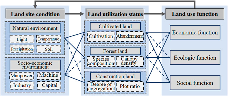
The reason and risk for cultivated land abandonment could be explained by the coupling framework of the land use “Condition-State-Function” (Figure 1). In 2008, the concept of land use functions was put forward by the European Union in the Sixth Framework Programme for Sustainability Impact Assessment: Tools for Environmental Social and Effects of Multifunctional Land Use in Europe Regions. This concept was accepted as the private or public products and services provided by different land use states, including economic function, ecologic function, and social function (Helming et al., 2008; Pérez-Soba et al., 2008; Liu et al., 2016). The continuous supply of functions requires the maintenance of a land use status with suitable site conditions. With optimal conditions in terms of light, temperature, precipitation, and soil, natural ecosystems (such as forest land and wetlands) can provide the service of ecological and climate regulation; in contrast, artificial ecosystems (such as industrial land and commercial areas) can provide economic benefits (Mitsuda and Ito, 2011). However, for semi-natural ecosystems (such as cultivated land and gardens), suitable tillage conditions are as important as the continuous and stable input of production factors for system maintenance and function supplement (Foley et al., 2011). Natural suitability, economic feasibility, and social acceptability are considered essential conditions for the maintenance of land use systems (Wang et al., 2016; Li et al., 2020). In turn, the requirement for some ecosystem services provides feedback on the land use state, prompting the generation of corresponding site conditions for maintenance (Wei et al., 2017). In this sense, the spatial matching between land supply and human demand directly determines the sustainability of land use status.
In 1997, the central government of China promoted the “Land Management Law,” in which the cultivated land requisition-compensation balance (CLRB) system was proposed formally. At the national level, the CLRB was formulated to take urban development and food demand into account, based on limited land resources. However, at the district level, preferential arrangements were provided for urban development in flat areas, while ignoring the site conditions of cultivated land and the services demanded by farmers in mountainous areas, leading to spatial mismatch. This process is generally overlooked in large-scale studies (Xiong et al., 2020; Chen et al., 2022). The abandonment phenomenon of cultivated land is resulted from its own attributes of resources as well as multi-dimensional interaction between natural geography and social economic environments (Helming et al., 2008; Renwick et al., 2013). The quantity, quality, function and spatial distribution characteristics of fragmentation or scale of the regional land resources themselves are the result of the accumulation of the long-term coupling effects of natural and human factors in the region, which not only is the basis for future land use but also determines the attractiveness level of the additional investment in land use and the ease of land use. It ultimately influences the decision of farmers and herders in the land use (Tian et al., 2023). Although the research of traditional regression model has revealed the effects of single factor on the utilization of cultivated land (Prishchepov et al., 2013; Zhang et al., 2014), it usually fails to explain the mechanisms of multi-factors. Recently, the machine learning has been applied in the multivariate questions, such as the crop yield and food security (Giulia et al., 2022; Balsher et al., 2023), which provides a new method for the research to explain the mechanisms of the abandonment of cultivated land in mountainous areas.
Considering the functional demands of land, a scheme based on NRRB is proposed to resolve the abandonment of CCL. The following questions are answered: 1) What happened in the spatial arrangement and use ratio for cultivated land in mountainous areas under the CLRB system? 2) What is driving the changes? 3) What is the impact of these changes on the regional grain production capacity? Based on the results, we tried to establish an evaluation system of cultivated land reserve resources to screen out CAFL. Furthermore, a spatial optimization plan for the replacement of abandoned CCL in mountainous areas and CAFL in submontane areas is proposed to compensate for the loss of grain production capacity.
2 Background
Almost all countries have formulated laws and regulations to protect cultivated land (Van Vliet, 2019). The role of the CLRB in China is to curb the reckless requisition of cultivated land for urbanization (Sun et al., 2014). Statistics indicate that 200 × 104 hm2 of cultivated land were compensated due to the CLRB during 2001–2010 (MLR, 2012), largely making up for the loss of cultivated land from construction. However, since 2008, numerous CLRB projects have been implemented with another policy, namely, the linkage of increase and decrease (LID) of urban and rural construction land, compensating the loss of cultivated land by reclaiming rural construction land. The reason for increased number of projects is the joint acquisition of economic and social benefits for local governments. By reclaiming construction land for cultivated, The village collective were able to obtain the economic benefits, and immigrant will would have better living conditions. (Shen et al., 2017; Liu et al., 2019). Statistics show that about 590 × 109 yuan capital has been invested into the countryside since 2012 due to the implementation of the LID (Ye, 2020). However, as a result, cultivated land was shifted from plains to mountainous areas (Li and Hu, 2021), increasing the risk of abandonment.
The ecological environment is another focus for the development of countries now (Yang and Li, 2000; Norse and Ju, 2015). If wetlands, forest lands, grasslands, among others, are converted into construction land and cultivated land, their ecologic functions, such as soil and water conservation, climate regulation, and biodiversity, may be destroyed (Foley et al., 2005; Mamat et al., 2014). The Chinese government prohibits the destruction of the ecological environment during urban construction and the reclamation of cultivated land for agricultural purposes (Shen et al., 2017), exploring the ecological land requisition-compensation balance (Song et al., 2015; Zhang et al., 2015). The forest land requisition-compensation balance in China has gone through two stages. The first stage is the quantitative balance, that is, the area of compensatory forest land shall not be less than that of the requisitioned forest land. The second stage is total quantity control, that is, the conversion of forest land to non-forest land needs to be strictly restricted, and ensuring the amount of forest land occupation is controlled, with the aim to maintain the forest areas. Compared with the CLRB, the intensity of the management of the forest land requisition-compensation balance tends to tighten. This has brought local governments to a standstill in dealing with land disputes for urban construction, cultivated land replenishment, and environmental protection. By contrast, it appears more flexible to the wetland mitigation bank system in the United States and the eco-account system in Germany (Kaplowitz et al., 2005; Pröbstl-Haider and Ammer, 2017). To avoid losses of ecological land and to maintain the ecological value, they require that ecological land should be newly built, restored, conserved, or enhanced in another area before the former ecological land is occupied.
3 Methodology
3.1 Study Area
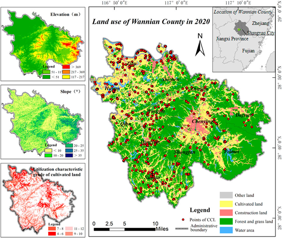
Wannian County (28°30′15″-28°54′5″N, 116°46′48′-117°15′10″E) is located in the west of the central part of Shangrao City, Jiangxi Province, China (Figure 2). It is an important area of the Poyang Lake Plain, which is one of the nine major commodity grain bases in the country. A high grain production is therefore of great significance to China’s food security. The terrain is mostly mountainous, high in the southeast and low in the northwest, and known as “six mountains, one water, and two penny cultivated land.” About 58.5% of cultivated land is distributed on the hills and gentle slopes on both sides of the river; forest land is widely distributed in the territory, reaching a coverage of 64.1%. Most rural settlements are distributed in river valleys in hilly areas, and some are dispersed in mountainous areas. The climate is subtropical monsoon humid climate, with an annual average temperature of 17.4°C and a precipitation of 1,808.0 mm, facilitating abundant crop and natural vegetation growth. Siltstone is the main soil parent material; under the prevailing climatic conditions, it is easily reclaimed to cultivated land.
3.2 Research framework and data source
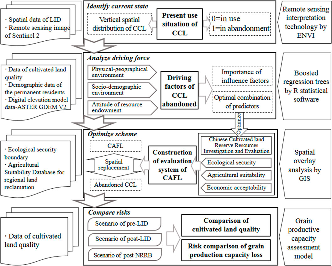
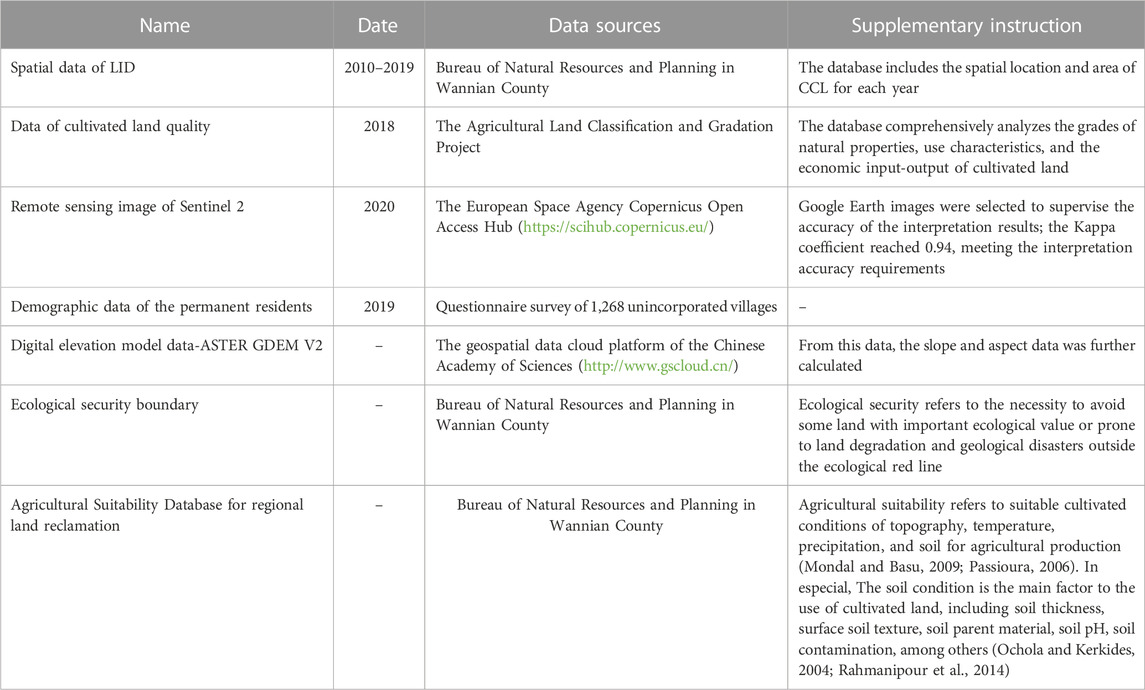
Figure 3 presented our research framework, and it included four main steps: 1) Identifying the distribution and use situation of CCL: Land use datasets in 2020 were obtained through remote sensing interpretation technology, including residential land, transportation land, cultivated land, and forest land; the forest land was divided into dense, sparse, and other forest land, based on canopy density. The CCL presented as forest land in 2020 were then identified as abandonment, based on the LID spatial data. 2) Machine learning statistical model of boosted regression trees was utilized to analyze the driving factors of abandonment: Based on the data of permanent population, elevation, slope and cultivated land quality, etc., three first-level indicators of physical-geographical environment, socio-demographic environment and attitude of resource endowment were characterized, and used as independent variables, while the condition of CCL was taken as the dependent variable. 3) Constructing the CAFL replacement evaluation system: Based on the analysis results of the driving factors of arable land abandonment, the evaluation index Chinese Cultivated land Reserve Resources Investigation and Evaluation was optimized. 4) Risk Comparison of grain production capacity loss: Based on the data of cultivated land quality, the grain productive capacity assessment model was utilized to estimate the differences in the loss of regional grain productivity capacity under the three scenarios: pre-LID, post-LID, and post-NRRB. It should be noted that the agricultural quality grade of CAFL was assigned as that of cultivated land nearby. The main data sources used in this study are listed in Table 1.
3.3 Boosted regression trees (BRT)
BRT, the machine learning statistical model, has been widely used in the mechanism research of environmental change. Compared to traditional statistical model, a BRT model easily captures complex and non-linear relationships (Li and Hu, 2021). It can capture the importance and marginal effect of independent variables. The importance can quantify the contribution of each independent variable, and the marginal effect shows the potential impact of independent variables as their magnitudes vary (Elith et al., 2008). The model was performed in R statistical software by using the gbm package with a “bernoulli” distribution.
3.3.1 Parameter settings
Four parameters require to be specified are tree complexity (TC), learning rate (LR), number of trees (NT), and bagging fraction (BF). TC determines the number of nodes in each tree and controls the interaction level. LR represents the contribution of each tree to the final model. NT relies on a combination of TC and LR and is recommended for sizes larger than 1,000. BF sets the proportion of randomly selected data used for model training and validation. Given our relatively small sampling dataset, BF was set at 0.50 (Soykan et al., 2014) while TC was set at 5 as suggested by Elith et al. (2008). LR and BF are set to 0.001 and 0.70, respectively. The BRT model obtained the highest coefficient of determination (R2) with the optimal NT in the range of 2,000–10,000 was considered as given the optimal parameter settings.
3.3.2 Importance of influence factors on CCL abandonment
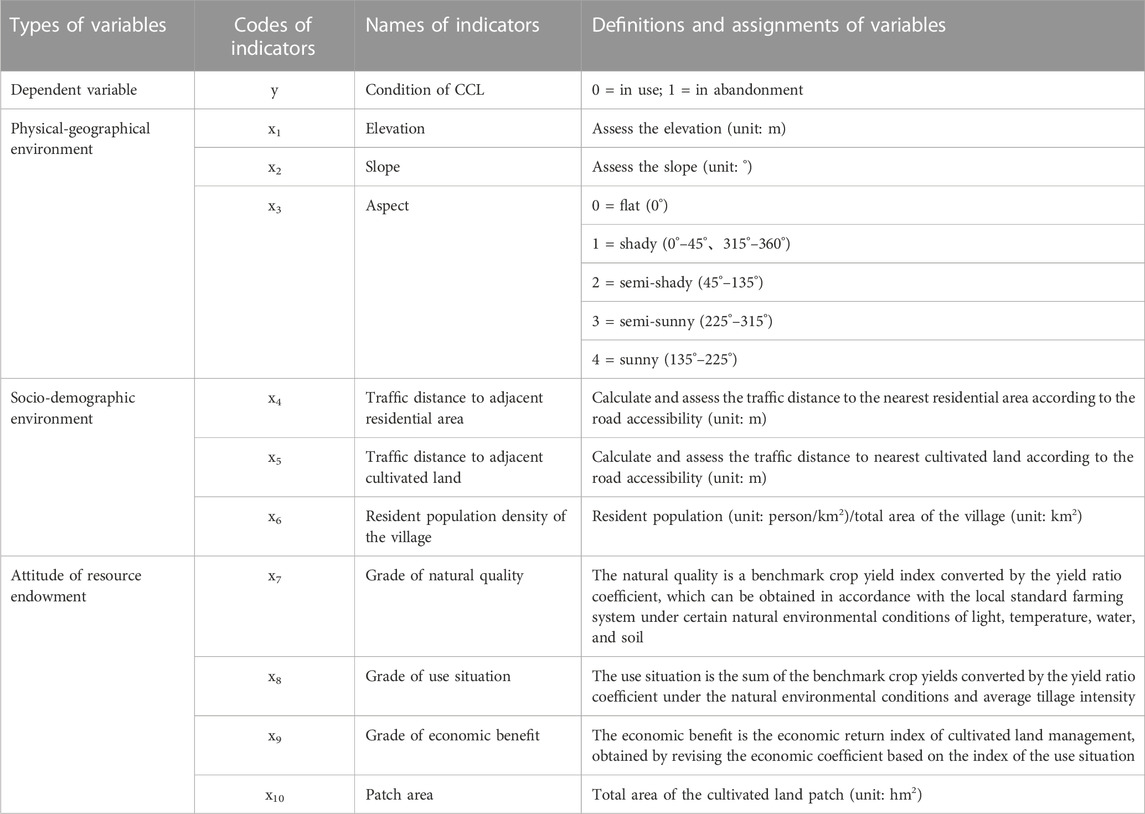
The relative importance (or contribution) of each variable can be measured based on the number of times the variable is selected for splitting, weighted by the squared improvement to the model, and averaged over all trees (Friedman, 2001). As the specific site conditions of cultivated land, physico-geographical environment, socio-demographic environment, and resource endowment attributes were identified as the three types of variables that may affect the “natural” abandonment of cultivated land. The corresponding influence factors were obtained from previous studies, the specific indicators were determined (Table 2).
3.3.3 Determining optimal combination of influence factors
The optimal combination of influence factors used for spatial prediction of CAFL is determined by a variable selection approach based on the BRT algorithm, which is performed in two steps. First, a BRT model is used to calculate the relative importance of all 10 variables. Pearson correlation analysis was then performed to eliminate redundant variables. Second, a BRT algorithm-based backward selection approach was performed to select the optimal number of variables by eliminating the least important variable step by step: 1) a BRT model was built to rank the non-redundant variables; 2) the least important variable was eliminated; 3) the retained variables were used to build a new BRT model and their importance was re-ranked. The optimal number of variables was determined by the highest coefficient of determination (R2) among these BRT models.
3.4 Grain productive capacity assessment model
The actual grain yield isn’t only affected by the quality factors of cultivated land but also restricted by the regional agricultural input and agricultural technology management (Xie et al., 2017). The grain productive capacity refers to the highest yield of a fine crop variety per unit area that might be obtained assuming all or part of the production factors are in the optimum state, not considering agricultural input and agricultural technology management; the value is higher than the actual grain yield. Therefore, the light-temperature (climatic) productivity potential index was set as the starting point for calculations. Soil, site, plot, and agricultural infrastructure conditions were considered individually, based on their influence on the productivity potential (Jiang et al., 2017). The calculation formula is as follows:
Where
4 Results
4.1 Distribution characteristic of compensation cultivated land
From 2010 to 2020, the total area of CCL in Wannian County reached about 232.47 hm2 in the scenario of post-LID. The CCL reclamation mainly occurred from 2011 to 2012 and 2017 to 2019, with no reclamation in 2014 and 2015. The average elevation of reclaimed land fluctuated upward from 154.71 m in 2010 to 192.47 m in 2019 (Figure 4), much higher than 50.70 m, the same figure of cultivated land of county-level in the basic years. Further analysis of annual variations of the elevation distribution of CCL demonstrated that the median of the average elevation of CCL had a gentle trend to climb up. To be more specific, it went up from 26 m, the lowest value in 2011 to 146 m, and the highest value in 2018. Moreover, the peak value went up from 169.5 m in 2011 to 290 m in 2019. In the aspect of upper and lower quartiles, this figure gradually tended to reach the highest value, deviating from the median (Figure 4). It can be seen that the height of CCL showed a trend to climb up. Considering the number of patches of compensatory land, we can find that the average patch area of CCL decreased from 1.31 hm2 in 2010 to 0.19 hm2 in 2018 through the analysis. Therefore, the next conclusion can be drawn that the CCL showed a trend to be fragmented gradually.
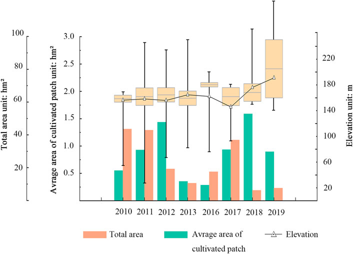
FIGURE 4. Statistics on the area and elevation of CCL by LID projects from 2010 to 2019 in Wannian County.
4.2 Analysis of the reasons for the abandonment
According to statistics, the abandoned area of the CCL was 34.34 hm2, accounting for 14.77% of the total area. Based on the BRT model, the relative contributions of the influence factors to the CCL abandonment are presented in Figure 5A. The dominant indicators influencing the CCL abandonment were the elevation (x1), traffic distance to adjacent cultivated land (x5), and patch area (x10), with 51.28%, 22.00%, and 18.00% contribution rate, respectively. The marginal effects were further analyzed and are shown in Figures 5B, C. When the elevation is below 80 m or traffic distance to adjacent cultivated land is below 100 m, it showed a positive correlation with the CCL abandonment, demonstrating that the higher the elevation or the greater distance is, the easier CCL is to be abandoned. In contrast, a negative correlation with the CCL abandonment was observed for the patch area below 0.12 hm2, which tells us that the larger the area of CCL is, the less likely it is to be abandoned. However, at elevation above 80 m, it showed a negative correlation with the CCL abandonment, which cannot be explained by a marginal correlation of a single factor.
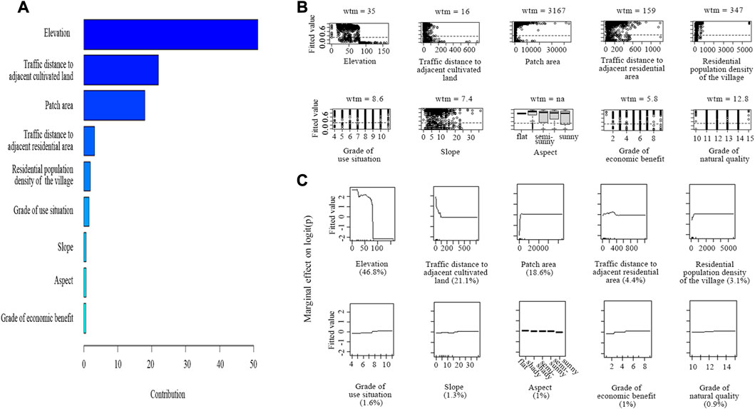
FIGURE 5. Influence of main driving factors of CCL abandonment. (A) Contributions (%) of influence factors on CCL abandonment. (B) Distribution of CCL in each explanatory variable. (C) Marginal effects of the most important explanatory variables.
Further pairwise interaction effects between the influence factors were determined in Figure 6A. The cultivated land use showed obvious differences only in these situations: x1-x10, x1-x5, x5-x10. The pairwise interaction effects on the CCL abandonment was represented in three-dimensional partial dependence plots (Figure 6B). To be more specific, when it comes to these three situations, ① x1 > 80m ∩ x10 < 0.12 hm2, ② x1 > 80 m ∩ x5 > 75 m, ③ x5 > 75 m ∩ x10 < 0.12 hm2, the general trend of abandonment can be seen clearly. To sum up, the possibility of CCL abandonment is higher in these four situations, and it will decrease on the contrary.
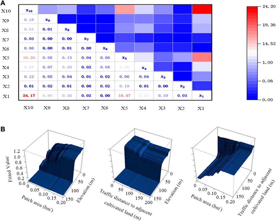
FIGURE 6. The optimal combination of influence factors on CCL abandonment. (A) The contributions of pairwise interaction effects on CF abandonment. (B) Three-dimensional partial dependence plots representing the pairwise interaction effects between the most important variables.
4.3 Construction of the evaluation system of CAFL
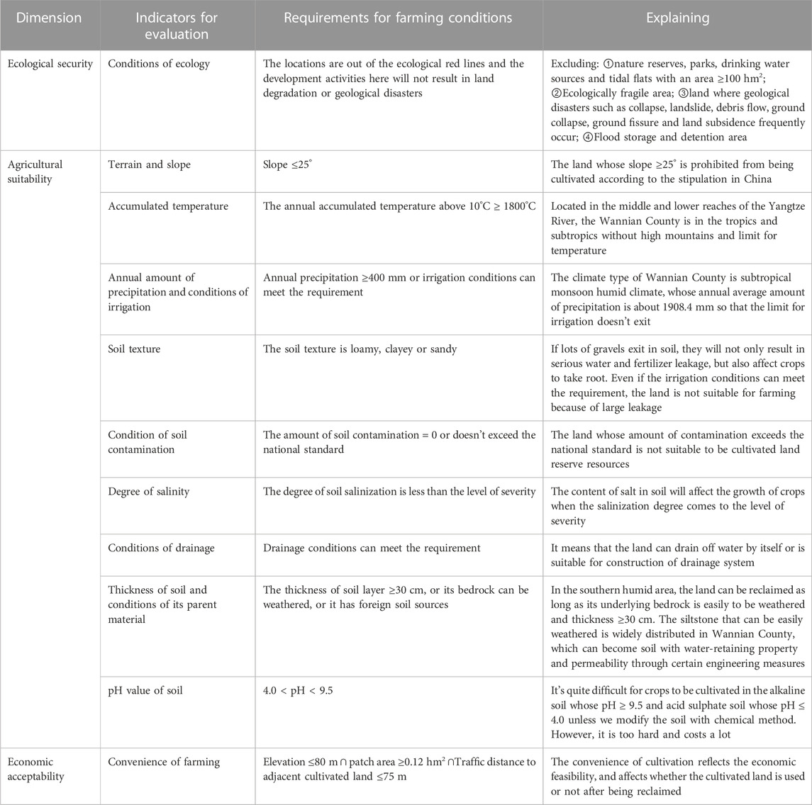
According to the Chinese system of “Technical Program of National Cultivated land Reserve Resources Investigation and Evaluation,” the main evaluation contents of suitable cultivated land include ecological security and agricultural suitability. These are some of the direct site condition factors of crop growth from the theoretical perspective. According to the coupling framework of land use “Condition-Status-Function” sustainable land use must also be matched with functional demand. As shown in the analysis of reasons for abandonment, elevation, traffic distance to adjacent cultivated land, and patch area are indirect factors for the sustainable use of cultivated land. So the research results were taken as the indicators of farming convenience, representing the economic acceptability. Finally, the evaluation system of cultivated land reserve resources suitable for reclamation and use is established (Table 3). The minimum limiting factor method was adopted to comprehensively evaluate the forest land in the study area. That is, only if all requirements are met, the one can be considered as CAFL, and as the replaced target for abandoned CCL.
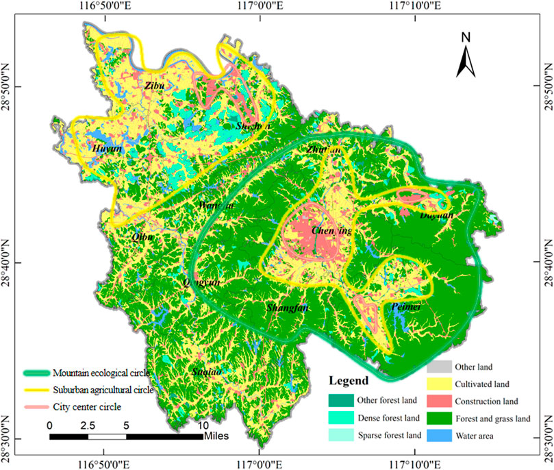
The evaluation results show that the area of the CAFL in Wannian County is about 3,183.39 hm2, with a dense forest area of 2,809.26 hm2, accounting for 88.25%. The areas of sparse and other forest land are 63.98 and 310.15 hm2, respectively, accounting for 2.01% and 9.74%. As seen in Figure 7, the CAFL is mainly distributed in Zibu Town, Shizhen Town, and Huyun Township, with a flat terrain in the northwest. Among them, dense forest land is mainly distributed in Shizhen Town, Zibu Town, and Huyun Township, whereas other forest land can be mainly found in Suqiao Township, Shizhen Town, and Huyun Township and sparse forest land in Peimei Town, Dayuan Town, and Zhutian Township.
4.4 Grain production capacity loss in different scenarios
According to the statistics of cultivated land quality, the grade of natural quality, use situation, economic benefit of the cultivated land in Wannian County were divided into 3 categories, the high level (4–7), the medium level (8–10) and the low level (11–13). As shown in Figures 8A, B, the area weighted average of the natural quality of cultivated land in the whole area is 9.27 grade, and that of the use situation one and economic benefit ones are 7.32 grade and 8.36 grade, respectively. By contrast, the area weighted average of the natural quality of the CCL for LID is 9.26 grade, and that of the use situation one and economic benefit ones are 7.47 grade and 8.78 grade, partly. The average quality is lower than that of the cultivated land in the whole county. As shown in Figure 8C, for the abandon one of the CCL, the weighted average value for area of the natural quality is 9.49 grade, and that of the use situation and economic benefit ones are 8.5 grade and 9.25 grade, therefore, the average quality of the abandon one of the CCL is even lower. Next, the total grain production capacity loss caused by the CCL abandonment after LID was calculated with the calculation formula of grain production capacity 5), which was 297.48 t.
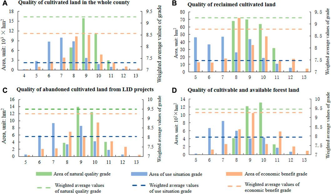
FIGURE 8. The quality of various types of cultivated land of Wannian County in different scenarios. (A) Quality of cultivated land in the whole county. (B) Quality of reclaimed cultivated land. (C) Quality of abandoned land from LID projects. (D) Quality of cultivable and available forest land.
In the scenario of post-NRRB, the area-weighted average of the natural quality of the cultivated land reclaimed from CAFL was 9.45 grade, whereas the values for the use situation ones and economic benefit ones were 7.94 grade and 9.26 grade, respectively (Figure 8D). These levels are slightly lower than that of the cultivated land in the entire county but it is still slightly higher than that of abandoned CCL. With the grain productive capacity assessment, it was calculated that about 38,498.84 t of grain production capacity would be obtained in the whole county by reclaiming the CAFL, including 33,910.67 t from dense forest land, 651.30 t from sparse forest land, and 3,936.87 t from other forest land, accounting for 88.08%, 1.69%, and 10.23% of the total, respectively. The loss of 297.48 t of grain production capacity from abandoned CCL in mountains, accounting for 12.5% of the regional total, can be made up only by replacing and reclaiming the sparse forest land in suburbs.
5 Discussion
5.1 Results comparison and interpretation of reasons for the abandonment
Since the mid-20th century, the rate of conversion of natural ecosystem to cultivated land has increased rapidly (Ramankutty and Foley, 1999) while abandonment is also happening. Estimates suggest that approximately 1.5 × 10⁶ km2 of cropland was abandoned globally between 1700 and 1990 (Ramankutty and Foley, 1999). We found that over the past decade, China’s mountainous regions have been undergoing cultivated land reclamation at the same time as abandonment, but with the difference that the new cultivated land comes mainly from the abandoned artificial ecosystem, namely, rural settlements, followed by new abandonment. Old abandonment in the mountains often occurs where natural conditions are unfavourable to agriculture (Hinojosa et al., 2016). Factors contributing to unfavourable agricultural suitability include land fertility (Alix-Garcia et al., 2012), altitude (Yang et al., 2019), soil erosion (Pepe et al., 2019), and climate change (Lambin et al., 2003). The external causes in the national market economy, which caused the emigration of the young population to work in the cities and the importation of goods that were formerly produced in the mountains (Lasanta et al., 2017). Xu et al. (2019) note that agricultural abandonment is generally driven by rural–urban migration, where better economic opportunities can be found. Our research results show that new abandonment is not related to agricultural suitability such as cultivated land quality, slope and aspect, but rather to its altitude, distance to adjacent cultivated land and patch area. The reason is that the unit land and labor economic output rates of scattered cultivated land are very limited, which makes agricultural suitability no longer the primary reference factor for cultivated land use. The Chinese government is offering compensation for large-scale grain production, through which farmers can receive more subsidies to boost labor productivity. This makes the realization of large-scale agricultural production become the primary basis of cultivated land use.
The cause of new abandonment in mountainous is not a single factor, but a complex multi-factor problem, namely, the inefficient space allocation caused by the implementation of CLRB, without fully considering the coupling relationship among land site conditions, land use status, and land function requirements. Land marginalization due to unsatisfactory land suitability and reduced economic viability is the root cause of cropland abandonment (Lasanta et al., 2017). According to Von Thunen’s agricultural location theory, the space allocation of agricultural land is mainly determined by the transportation cost, with the influence factors of freight, distance, and item weight, forming a concentric structure dominated by a certain crop in a certain circle (Figure 9). In the process of industrialization and urbanization, humans in the mountainous agro-ecosystems have gradually immigrated out of the remote mountains, either actively or passively (Ramankutty and Foley, 1999; Chen et al., 2022). The demand degree of agricultural production in the original location decreased significantly for the immigrant farmers, whereas in the suburban areas in submontane regions, with a flat terrain, a high soil thickness, and agminated immigrants, the demand for land for cultivation increases (Lasanta et al., 2017). A recent review 276 households on the Loess Plateau found that farmers are unwilling to cultivate steep slopes or to employ recultivation on restored land due to the greater distance costs and lower grain yields when vegetation restoration programs don’t affect grain self-sufficiency (Wu et al., 2021). While compared to arable land, forest land provides mainly ecological but not economic functions for humans due to China’s forest protection policies (Mayer et al., 2005; Stahls et al., 2010). The provision of the ecological function, however, is independent of the transportation cost and is realized via telecoupling (Li et al., 2023).
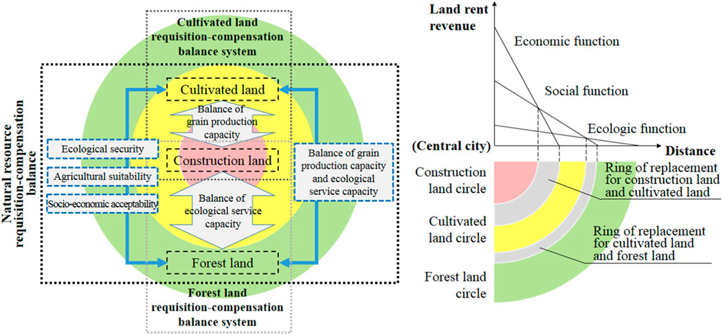
FIGURE 9. The scheme of land use space optimization. Note: For the same land use service, the land rent revenue declines as the increase of the distance from the central city results in higher freight costs. It can be the marginal demand when coming to 0 since this condition is not economically reasonable even if the site condition makes sense. The line connecting the point of central city (freight = 0) and that of marginal demand is called “the curve of rent.” Each kind of land use function has its own curve, whose slope is dependent on the rate of freight. Therefore, the slope will be higher if the function is hard to be transported while being lower on the contrary. Since it is an economic rational activity aiming at maximizing land rent income, the inner rings of the cultivated land and forest land concentric circles are the most suitable districts for the expansion of land economic and society functions respectively, and the mountain area farthest from the central city becomes that for the development of forest due to its lowest freight rate of ecological function.
5.2 Improvement scheme for requisition-compensation balance
A broader approach in regions faced with land abandonment includes the consideration of the economic acceptability (human, natural, etc.) available to foster rural development beyond a sole focus on agricultural production (Zeng et al., 2022; Alan et al., 2013). If the land cannot supply economic function needed and there are significant benefits to the environment of land abandonment it may be unwise to concentrate policies on maintaining agricultural use (Alexander et al., 2013). Regional and local land use planning and polices provided for changing the structure of farms will affect the process of land abandonment (Alan et al., 2013). According to Von Thunen’s theory and realistic demands, the matching of functional requirements considered further that construction land is required in the city center circle, and cultivated land and forest land are required in suburban agricultural circle and mountain ecological circle, respectively (Figure 7). Therefore, we propose to establish the NRRB scheme for rational spatial replacement among cultivated land, forest land, and construction land. The goal is to make various natural resources maintain their sustainable use and perform effective functions.
In 2018, the responsibilities of forest and grass land, cultivated land, and construction land were consolidated under the administration Ministry of Natural Resources, providing administrative guarantees for the coordinated management of the three types of land. Based on the research results of economic acceptability in this paper, it is possible to assess and screen out the rural construction land with a high probability of being abandoned after reclamation. When cultivated land in cities is occupied by construction, the construction land in remote rural mountains could be restored to forest and grass land, integrating with the surrounding green environment. At the same time, CAFL in migration destinations should be selected and reclaimed as a supplement to the cultivated land occupied in cities, in accordance with the criteria of grain production capacity balance. Cultivated land is given priority over forested land in spatial arrangements due to stricter usage conditions and more pressing requirements for grain production. The NRRB scheme can ensure that all types of land are used effectively, perform their functions and avoid loss of regional food production capacity.
5.3 Implications and shortcomings
Vegetation restoration strategies adapted to local conditions can reduce the risk of grain shortage for 9.30–11.97 million farmers and contribute to a more balanced development and the sustainability of vegetation restoration in mountainous areas (Zeng et al., 2022). Therefore, the CLRB system needs to be more elaborately designed when involved in the trade-offs between green and grain; this would help to make up for the loss of regional grain production capacity caused by the CLRB system. Meanwhile, it promotes the formation of land use patterns for efficient agricultural use due to compliance with Von Thunen’s agricultural location theory. However, although achieving the quantitative balance, the volume and ecological service capacity of compensatory forest land aren’t balanced to occupied one, and the loss is difficult to make up in the short term. Limited by the length of the article, we didn’t calculate the loss amount of service capacity and didn’t analyze the required time. However, in the tropical and subtropical regions of southern China, the main mountainous areas of China and with abundant rain and heat, it can be restored to shrub forests in a short period of time and to arbor forests with a certain degree of canopy density after several years (Ashton and Zhu, 2020). The historical observation by Google Earth provides evidence that the average canopy closure of abandoned CCL in the study area reached 43% after 5 years without intervention. On the other hand, the ecological regulation service for forest land mainly includes soil and water conservation, carbon fixation, and biodiversity. Studies on soil and water conservation have shown that abandoned cultivated land in mountainous areas will reduce soil disturbance and have a positive effect on soil erosion control; even in an environment prone to soil erosion, the content of water-stable aggregates and the conversion rate of soil carbon will increase gradually over time. (Dai et al., 2007; Dai et al., 2008; Renwick et al., 2013). Studies on carbon fixation have shown that the carbon fixation rate is closely related to the tree age structure, and the fixation rate of young and middle-age forest is relatively high, whereas that of mature and over-mature forest declines gradually; in this sense, the compensated forest land has a stronger effect on carbon fixation (Xu et al., 2010). Consequently, as long as the ecological restoration management measures are adapted and a certain period of time is allowed, compensated forest land could provide the same ecological regulation services as occupied one.
6 Conclusion
Taking Wannian County, a typical mountainous agricultural area in China, as an example, this study explored the impact of the CLRB system and the LID policy on the use of cultivated land in mountainous counties from a micro-perspective. The results show that from 2010 to 2020, CCL reclaimed from rural settlements has shifted uphill, with considerable fragmentation and an abandonment rate of 14.77%. The new abandonment is not related to agricultural suitability such as cultivated land quality, slope and aspect, but rather to its altitude, distance to adjacent cultivated land and patch area. This isn’t the same as the abandonment of cultivated land reclaimed spontaneously from natural ecosystems by humans. Finally, this resulted in a 297.48 t loss of grain production capacity throughout the county. Based on the results of driving force analysis, a solution from NRRB that restructure the spatial layout arrangement of cultivated land, forest land and construction land, was put forward under the coupling framework of land use “Condition-Status-Function.” The CAFL could be identified though the establishment of a new evaluation system for cultivated land reserve resources. The quality of the cultivated land obtained from the reclamation of CAFL would be better than that of abandoned CCL. By reclaiming the spare forest land from a portion of the CALF, it is sufficient to compensate for the loss of grain production capacity from the abandoned CCL, and reduces the risk of new abandonment. While this solution would also result in a certain loss of ecological regulation services in the short term. However, in most southern mountainous areas of China, the forest cover would be restored quickly with suitable ecological restoration management measures, and provides an ecological regulation service equivalent to that of reclaimed CAFL.
Data availability statement
The datasets presented in this article are not readily available because the datasets including the spatial data of LID in the study area sourced from the non-public information of the local government. Requests to access the datasets should be directed to the corresponding author, Li Chao (bGljaGFvbm9uZ2RhQDE2My5jb20=).
Author contributions
Conceptualization, ZX; data curation, ZX, and YZ; formal analysis, ZX, and YZ; funding acquisition, ZX; investigation, SF, and CL; methodology, ZX and YZ; project administration, SF and SD; resources, SF and SD; software, ZX, YZ, and SD; supervision, CL and SD; validation, ZX, YZ, and SD; visualization, YZ and SD; writing—original draft, ZX and SD; writing—review and editing ZX and SD.
Funding
The authors gratefully acknowledge the financial support by the National Natural Science Foundation of China (42201280) and the Major Project Funding for Social Science Research base in Fujian Province Social Science Planning (FJ2021MJDZ019).
Conflict of interest
The authors declare that the research was conducted in the absence of any commercial or financial relationships that could be construed as a potential conflict of interest.
Publisher’s note
All claims expressed in this article are solely those of the authors and do not necessarily represent those of their affiliated organizations, or those of the publisher, the editors and the reviewers. Any product that may be evaluated in this article, or claim that may be made by its manufacturer, is not guaranteed or endorsed by the publisher.
References
Alan, R., Torbjorn, J., Peter, H. V., Cesar, R. G., Wolfgang, B., Alexander, G., et al. (2013). Policy reform and agricultural land abandonment in the EU. Land Use Pol. 30 (2013), 446–457. doi:10.1016/j.landusepol.2012.04.005
Alexander, V., Daniel, M., Maxim, D., Baumann, M., and Radeloff, V. C. (2013). Determinants of agricultural land abandonment in post-Soviet European Russia. Land Use Pol. 30 (1), 873–884. doi:10.1016/j.landusepol.2012.06.011
Alix-Garcia, J., Kuemmerle, T., and Radeloff, V. (2012). Prices, land tenure institutions, and geography: A matching analysis of farmland abandonment in post-socialist eastern Europe. Land Econ. 88, 425–443. doi:10.3368/le.88.3.425
Ashton, P., and Zhu, H. (2020). The tropical-subtropical evergreen forest transition in East Asia: An exploration. Plant Divers. 42 (4), 255–280. doi:10.1016/j.pld.2020.04.001
Balsher, S., Zia, M., Ramankutty, N., and Kandlikar, M. (2023). How can machine learning help in understanding the impact of climate change on crop yields? Environ. Res. Lett. 18, 024008. doi:10.1088/1748-9326/acb164
Baumann, M., Kuemmerle, T., Elbakidze, M., Ozdogan, M., Radeloff, V. C., Keuler, N. S., et al. (2011). Patterns and drivers of post-socialist farmland abandonment in Western Ukraine. Land Use Pol. 28 (3), 552–562. doi:10.1016/j.landusepol.2010.11.003
Chen, L., Meadows, M. E., Liu, Y., and Lin, Y. (2021). Examining pathways linking rural labour outflows to the abandonment of arable land in China. Popul. Space Place 28 (1), e2519. doi:10.1002/psp.2519
Chen, H., Tan, Y., Xiao, W., Li, G., Meng, F., He, T., et al. (2022). Urbanization in China drives farmland uphill under the constraint of the requisition–compensation balance. Sci. Total Environ. 831, 154895. doi:10.1016/j.scitotenv.2022.154895
Dai, Q., Liu, G., Xue, S., Qu, S., and Li, X. (2007). Dynamics of soil water stable aggregates and relationship with soil properties on abandoned arable land in eroded hilly loess plateau. J. Soil Water Conserv. 21 (2), 61–64, 77. (in Chinese). doi:10.13870/j.cnki.stbcxb.2007.02.016
Dai, Q., Liu, G., Xue, S., Yu, N., Zhang, C., and Lan, X. (2008). Active organic matter and carbon pool management index of soil at the abandoned cropland in erosion environment. J. Northwest For. Univ. 23 (6), 24–28. (in Chinese).
Díaz, G., Nahuelhual, L., Echeverría, C., and Marín, S. (2011). Drivers of land abandonment in Southern Chile and implications for landscape planning. Landsc. Urban Plan. 99 (3-4), 207–217. doi:10.1016/j.landurbplan.2010.11.005
Elith, J., Leathwick, J., and Hastie, T. (2008). A working guide to boosted regression trees. J. Anim. Ecol. 77 (2), 802–813. doi:10.1111/j.1365-2656.2008.01390.x
Estel, S., Kuemmerle, T., Alcántara, C., Levers, C., Prishchepov, A., and Hostert, P. (2015). Mapping farmland abandonment and recultivation across Europe using MODIS NDVI time series. Remote Sens. Environ. 163, 312–325. doi:10.1016/j.rse.2015.03.028
Foley, J., DeFries, R., Asner, G., Barford, C., Bonan, G., Carpenter, S. R., et al. (2005). Global consequences of land use. Science 309 (5734), 570–574. doi:10.1126/science.1111772
Foley, J., Ramankutty, N., Brauman, K., Cassidy, E. S., Gerber, J. S., Johnston, M., et al. (2011). Solutions for a cultivated planet. Nature 478 (7369), 337–342. doi:10.1038/nature10452
Friedman, J. (2001). Greedy function approximation: A gradient boosting machine. Ann. Stat. 29 (5), 1189–1232. doi:10.1214/aos/1013203451
Giulia, M., Alberto, B., Lorenzo, R., Jaiswal, S., Corea, M., Rivers, J., et al. (2022). Machine learning can guide food security efforts when primary data are not available. Nat. Food 3, 716–728. doi:10.1038/s43016-022-00587-8
Halpern, B., Frazier, M., Verstaen, J., Rayner, P. E., Clawson, G., Blanchard, J. L., et al. (2022). The environmental footprint of global food production. Nat. Sustain 5, 1027–1039. doi:10.1038/s41893-022-00965-x
Helming K., Pérez-Soba M., and Tabbush P., (Editors) (2008). Sustainability impact assessment of land use changes (Berlin, Heidelberg: Springer Berlin Heidelberg).
Hinojosa, L., Napoléone, C., Moulery, M. M., Lambin, E. F., et al. (2016). The “mountain effect” in the abandonment of grasslands: Insights from the French Southern Alps. Agr. Ecosyst. Environ. 221 (2016), 115–124. doi:10.1016/j.agee.2016.01.032
Isbell, F., Tilman, D., Reich, P., and Clark, A. T. (2019). Deficits of biodiversity and productivity linger a century after agricultural abandonment. Nat. Ecol. Evol. 3, 1533–1538. doi:10.1038/s41559-019-1012-1
Ito, J., Nishikori, M., Toyoshi, M., and Feuer, H. (2016). The contribution of land exchange institutions and markets in countering farmland abandonment in Japan. Land Use Pol. 57, 582–593. doi:10.1016/j.landusepol.2016.06.020
Jasper, V., Eitelberg, D. A., and Verburg, P. H. (2017). A global analysis of land take in cropland areas and production displacement from urbanization. Glob. Environ. 43, 107–115. doi:10.1016/j.gloenvcha.2017.02.001
Jiang, L., Deng, X., and Seto, K. C. (2013). The impact of urban expansion on agricultural land use intensity in China. Land Use Pol. 35, 33–39. doi:10.1016/j.landusepol.2013.04.011
Jiang, G., Zhang, R., Ma, W., Zhou, D., Wang, X., and He, X. (2017). Cultivated land productivity potential improvement in land consolidation schemes in Shenyang, China: Assessment and policy implications. Land Use Pol. 68, 80–88. doi:10.1016/j.landusepol.2017.07.001
Kaplowitz, M. D., Lupi, F., and Bailey, D. (2005). Cultivated land productivity potential improvement in land consolidation schemes in Shenyang, China: Assessment and policy implications. Wetland mitigation banking: A banker’s perspective 63 (3), 162–172. doi:10.2489/jswc.63.3.162
Lambin, E. F., Geist, H. J., and Lepers, E. (2003). Dynamics of land-use and land-cover change in tropical regions. Annu. Rev. Environ. Resour. 28, 205–241. doi:10.1146/annurev.energy.28.050302.105459
Lark, T., Spawn, S., Bougie, M., and Gibbs, H. (2020). Cropland expansion in the United States produces marginal yields at high costs to wildlife. Nat. Commun. 11, 4295. doi:10.1038/s41467-020-18045-z
Lasanta, T., Arnáez, J., Pascual, N., Ruiz-Flaño, P., Errea, M., and Lana-Renault, N. (2017). Space–time process and drivers of land abandonment in Europe. Catena 149 (3), 810–823. doi:10.1016/j.catena.2016.02.024
Li, Z., and Hu, D. (2021). Exploring the relationship between the 2D/3D architectural morphology and urban land surface temperature based on a boosted regression tree: A case study of beijing, China. Sustain. Cities Soc. 78, 103392. doi:10.1016/j.scs.2021.103392
Li, W., Wang, D., Liu, S., Zhu, Y., and Yan, Z. (2020). Reclamation of cultivated land reserves in northeast China: Indigenous ecological insecurity underlying national food security. Int. J. Env. Res. Pub. He. 17 (4), 1211. doi:10.3390/ijerph17041211
Li, W., An, M., Wu, H., An, H., Huang, H., and Khanal, R. (2023). The local coupling and telecoupling of urbanization and ecological environment quality based on multisource remote sensing data. J. Environ. Manage. 327, 116921. doi:10.1016/j.jenvman.2022.116921
Lian, X., Jiao, L., Hu, Y., and Liu, Z. (2022). Future climate imposes pressure on vulnerable ecological regions in China. Sci. Total Environ. 858, 159995. doi:10.1016/j.scitotenv.2022.159995
Liang, C., Penghui, J., Wei, C., Manchun, L., Liyan, W., Yuan, G., et al. (2015). Farmland protection policies and rapid urbanization in China: A case study for changzhou city. Land Use Pol. 48, 552–566. doi:10.1016/j.landusepol.2015.06.014
Liao, L., Long, H., Gao, X., and Ma, E. (2019). Effects of land use transitions and rural aging on agricultural production in China’s farming area: A perspective from changing labor employing quantity in the planting industry. Land Use Pol. 88, 104152. doi:10.1016/j.landusepol.2019.104152
Liu, C., Xu, Y., Sun, P., and Liu, J. (2016). Progress and prospects of multi-functionality of land use research. Prog. Geogr. 35 (9), 1087–1099. (in Chinese). doi:10.18306/dlkxjz.2016.09.004
Liu, L., Liu, Z., Gong, J., Wang, L., and Hu, Y. (2019). Quantifying the amount, heterogeneity, and pattern of farmland: Implications for China’s requisition-compensation balance of farmland policy. Land Use Pol. 81, 256–266. doi:10.1016/j.landusepol.2018.10.008
Mamat, Z., Yimit, H., Eziz, A., and Ablimit, A. (2014). Oasis land-use change and its effects on the eco-environment in Yanqi Basin, Xinjiang, China. Environ. Monit. Assess. 186 (1), 335–348. doi:10.1007/s10661-013-3377-y
Mayer, A., Kauppi, P., Angelstam, P., Zhang, Y., and Tikka, P. (2005). Importing timber, exporting ecological impact. Science 308:359–360. doi:10.1126/science.1109476
Mitsuda, Y., and Ito, S. (2011). A review of spatial-explicit factors determining spatial distribution of land use/land-use change. Landsc. Ecol. Eng. 7 (1), 117–125. doi:10.1007/s11355-010-0113-4
MLR (Ministry of Land and Resources) (2012). Ministry of land and resources of the people’s Republic of China. Beijing, China: National Land Consolidation Plan, 2011–2015. (in Chinese).
Mondal, P., and Basu, M. (2009). Adoption of precision agriculture technologies in India and in some developing countries: Scope, present status and strategies. Prog. Nat. Sci. 19 (6), 659–666. doi:10.1016/j.pnsc.2008.07.020
Norse, D., and Ju, X. (2015). Environmental costs of China’s food security. Agr. Ecosyst. Environ. 209, 5–14. doi:10.1016/j.agee.2015.02.014
Ochola, W., and Kerkides, P. (2004). An integrated indicator-based spatial decision support system for land quality assessment in Kenya. Comput. Electron. Agr. 45 (1-3), 3–26. doi:10.1016/j.compag.2004.05.005
Passioura, J. (2006). Increasing crop productivity when water is scarce—From breeding to field management. Agr. Water manage. 80 (1-3), 176–196. doi:10.1016/j.agwat.2005.07.012
Pepe, G., Mandarino, A., Raso, E., Scarpellini, P., Brandolini, P., and Cevasco, A. (2019). Investigation on farmland abandonment of terraced slopes using multitemporal data sources comparison and its implication on hydro-geomorphological processes. Water 11, 1552. doi:10.3390/w11081552
Pérez-Soba, M., Petit, S., Jones, L., Bertrand, N., Briquel, V., Omodei-Zorini, L., et al. (2008). “Land use functions—A multifunctionality approach to assess the impact of land use changes on land use sustainability,” in Sustainability impact assessment of land use changes (Berlin, Heidelberg: Springer), 375–404.
Prishchepov, A., Müller, D., Dubinin, M., Baumann, M., and Radeloff, V. (2013). Determinants of agricultural land abandonment in post-Soviet European Russia. Land Use Policy 30, 873–884. doi:10.1016/j.landusepol.2012.06.011
Pröbstl-Haider, V., and Ammer, U. (2017). Use of communal forests to establish an ecological accounting system–current state and new challenges due to the compensation regulation using the example of bavaria. Naturschutz Landschaftsplan. 49 (5), 164–172.
Rahmanipour, F., Marzaioli, R., Bahrami, H., Fereidouni, Z., and Bandarabadi, S. (2014). Assessment of soil quality indices in agricultural lands of Qazvin Province, Iran. Ecol. Indic. 40, 19–26. doi:10.1016/j.ecolind.2013.12.003
Ramankutty, N., and Foley, J. (1999). Estimating historical changes in global land cover: Croplands from 1700 to 1992. Glob. Biogeochem. Cy. 13 (4), 997–1027. doi:10.1029/1999GB900046
Renwick, A., Jansson, T., Verburg, P., Revoredo-Giha, C., Britz, W., Gocht, A., et al. (2013). Policy reform and agricultural land abandonment in the EU. Land Use Pol. 30 (1), 446–457. doi:10.1016/j.landusepol.2012.04.005
Shao, J., Zhang, S., and Li, X. (2015). Farmland marginalization in the mountainous areas: Characteristics, influencing factors and policy implications. J. Geogr. Sci. 25 (6), 701–722. doi:10.1007/s11442-015-1197-4
Shen, X., Wang, L., Wu, C., Lv, T., Lu, Z., Luo, W., et al. (2017). Local interests or centralized targets? How China’s local government implements the farmland policy of requisition–compensation balance. Land Use Pol. 67, 716–724. doi:10.1016/j.landusepol.2017.06.012
Song, W., and Zhang, Y. (2019). Farmland abandonment research progress: Influencing factors and simulation model. J. Resour. Ecol. 10 (4), 345–352. doi:10.5814/j.issn.1674-764x.2019.04.001
Song, W., Pijanowski, B., and Tayyebi, A. (2015). Urban expansion and its consumption of high-quality farmland in Beijing, China. Ecol. Indic. 54, 60–70. doi:10.1016/j.ecolind.2015.02.015
Song, S., Liang, X., Chen, H., and Mao, N. (2018). The simulation of cropland abandonment based on multi-agent system and land transformation model: A case study of mizhi county, shaanxi Province. J. Nat. Resour. 33 (3), 515–525. (in Chinese). doi:10.11849/zrzyxb.20170040
Soykan, C., Eguchi, T., Kohin, S., and Dewar, H. (2014). Prediction of fishing effort distributions using boosted regression trees. Ecol. Appl. 24 (1), 71–83. doi:10.1890/12-0826.1
Stahls, M., Mayer, A., Tikka, P., and Kauppi, P., (2010). Disparate geography of consumption, production, and environmental impacts. J. Ind. Ecol. 14:576–585. doi:10.1111/j.1530-9290.2010.00255.x
Sun, R., Sun, P., Wu, J., and Zhang, J. (2014). Effectiveness and limitations of cultivated land requisition-compensation balance policy in China. China Popul. Resour. Environ. 24, 41–46. (in Chinese). doi:10.3969/j.issn.1002-2104.2014.03.007
Tan, Y., Chen, H., Xiao, W., Meng, F., and He, T. (2021). Influence of farmland marginalization in mountainous and hilly areas on land use changes at the county level. Sci. Total Environ. 794, 149576. doi:10.1016/j.scitotenv.2021.149576
Tian, Y., Jiang, G., Wu, S., Zhou, D., Zhou, T., Tian, Y., et al. (2023). Cropland-grassland use conversions in the agro-pastoral areas of the Tibetan Plateau: Spatiotemporal pattern and driving mechanisms. Ecol. Indic. 146, 109819. doi:10.1016/j.ecolind.2022.109819
Van Vliet, J. (2019). Direct and indirect loss of natural area from urban expansion. Nat. Sustain. 2 (8), 755–763. doi:10.1038/s41893-019-0340-0
Varsha, V., and Paul, R. A. (2021). Pervasive cropland in protected areas highlight trade-offs between conservation and food security. PNAS 118 (4), e2010121118. doi:10.1073/pnas.2010121118
Wang, A., Tang, L., Yang, D., and Lei, H. (2016). Spatio-temporal variation of net anthropogenic nitrogen inputs in the upper Yangtze River basin from 1990 to 2012. China Earth Sci. 59 (11), 2189–2201. doi:10.1007/s11430-016-0014-6
Wei, H., Fan, W., Wang, X., Lu, N., Dong, X., Zhao, Y., et al. (2017). Integrating supply and social demand in ecosystem services assessment: A review. Ecosyst. Serv. 25, 15–27. doi:10.1016/j.ecoser.2017.03.017
Wu, X., Wang, S., and Fu, B. (2021). Multilevel analysis of factors affecting participants’ land reconversion willingness after the Grain for Green Program. Ambio 50 (7), 1394–1403. doi:10.1007/s13280-020-01475-w
Xie, Z., Gao, Y., Li, C., Zhou, J., and Zhang, T. (2017). Spatial heterogeneity of typical ecosystem services and their relationships in different ecological–functional zones in beijing–tianjin–hebei region, China. Sustainability 10 (1), 6. doi:10.3390/su10010006
Xin, L., and Li, X. (2018). China should not massively reclaim new farmland. Land Use Pol. 72, 12–15. doi:10.1016/j.landusepol.2017.12.023
Xiong, B., Chen, R., Xia, Z., Ye, C., and Anker, Y. (2020). Large-scale deforestation of mountainous areas during the 21st Century in Zhejiang Province. Land Degrad. Dev. 31 (14), 1761–1774. doi:10.1002/ldr.3563
Xu, B., Guo, Z., Piao, S., and Fang, J. (2010). Biomass carbon stocks in China’s forests between 2000 and 2050: A prediction based on forest biomass-age relationships. Sci. China Life Sci. 53 (7), 776–783. doi:10.1007/s11427-010-4030-4
Xu, D., Deng, X., Guo, S., and Liu, S. (2019). Labor migration and farmland abandonment in rural China: Empirical results and policy implications. J. Environ. Manage. 232, 738–750. doi:10.1016/j.jenvman.2018.11.136
Yang, H., and Li, X. (2000). Cultivated land and food supply in China. Land Use Pol. 17 (2), 73–88. doi:10.1016/S0264-8377(00)00008-9
Yang, T., Guo, X., Yu, X., Yue, D., and Wang, X. (2019). Driving force and model simulation of farmland abandonment in village scale based on multisourcr data. J. Arid. Land Resour. Environ. 33, 62–69. (in Chinses). doi:10.13448/j.cnki.jalre.2019.317
Yao, R., Yang, J., Zhang, T., Gao, P., Wang, X. P., Hong, L. Z., et al. (2014). Determination of site-specific management zones using soil physico-chemical properties and crop yields in coastal reclaimed farmland. Geoderma 232-234, 381–393. doi:10.1016/j.geoderma.2014.06.006
Ye, H. (2020). Optimization of land use guarantee policy for promoting integrated development of Yangtze River Delta. China Land 2020 (11), 4–9. (in Chinese).
Zeng, Y., Ran, L., Fang, N., Wang, Z., Xu, Z., &Lu, X., et al. (2022). How to balance green and grain in marginal mountainous areas? Earth's Future 10, e2021EF002552. doi:10.1029/2021EF002552
Zhang, Y., Li, X., and Song, W. (2014). Determinants of cropland abandonment at the parcel, household and village levels in mountain areas of China: A multi-level analysis. Land Use Pol. 41, 186–192. doi:10.1016/j.landusepol.2014.05.011
Zhang, P., He, L., Fan, X., Huo, P., Liu, Y., Zhang, T., et al. (2015). Ecosystem service value assessment and contribution factor analysis of land use change in Miyun County, China. Sustainability 7 (6), 7333–7356. doi:10.3390/su7067333
Keywords: mountainous area, cultivated land requisition-compensation balance, forest land requisition-compensation balance, cultivated land abandonment, grain production capacity, Wannian county
Citation: Xie Z, Fan S, Du S, Zheng Y and Li C (2023) Mechanism, risk, and solution of cultivated land reversion to mountains and abandonment in China. Front. Environ. Sci. 11:1120734. doi: 10.3389/fenvs.2023.1120734
Received: 10 December 2022; Accepted: 16 March 2023;
Published: 30 March 2023.
Edited by:
Minghong Tan, Institute of Geographic Sciences and Natural Resources Research (CAS), ChinaReviewed by:
Chao Liu, Central China Normal University, ChinaYifeng Tang, Huazhong University of Science and Technology, China
Copyright © 2023 Xie, Fan, Du, Zheng and Li. This is an open-access article distributed under the terms of the Creative Commons Attribution License (CC BY). The use, distribution or reproduction in other forums is permitted, provided the original author(s) and the copyright owner(s) are credited and that the original publication in this journal is cited, in accordance with accepted academic practice. No use, distribution or reproduction is permitted which does not comply with these terms.
*Correspondence: Chao Li, bGljaGFvbm9uZ2RhQDE2My5jb20=
 Zhen Xie
 Shenglong Fan1