 Bruce Thom
 John Hudson
 Pam Dean-Jones3
- 1School of Geosciences, Faculty of Science, The University of Sydney, Sydney, NSW, Australia
- 2NSW Coastal Council, Department Planning and Environment, Sydney, NSW, Australia
- 3Umwelt (Australia) Pty Limited, Newcastle, NSW, Australia
Estuaries along the southeast coast of Australia form distinctive biophysical types. Each type reflects both geological setting and a Holocene geomorphic history associated with the degree of infill driven by marine and terrestrial processes. Of the 180 estuaries found within the state of New South Wales (NSW) many occur in national parks or are not significantly modified by human activities. For those estuaries where human activities are directly impacting environmental conditions and social, cultural and economic functions of the waterways, the management challenge is more complex. We combine the biophysical and socio-economic characteristics for the NSW coast to identify four “estuary contexts”, referred to as: 1) intermittently closed and open lakes and lagoons (ICOLLs), 2) coastal lakes, 3) deltaic floodplains, and 4) drowned river valleys. Each context may require different governance arrangements to address the coastal management requirements as outlined in recently introduced NSW legislation and planning policy. Such arrangements become especially urgent given threats facing private and public assets in low-lying locations around the shores of these estuaries as sea level continues to rise and climate change adaptation strategies set out in local government Coastal Management Programs are developed and implemented.
1 Introduction
Differences in the spatial scale and biophysical characteristics or types of estuaries (including coastal lagoons) provide a framework for how they are managed and used (Kjerfve and Magill, 1989). Scale can dictate the need for multi-level management of the land and sea to maintain the ecological, cultural, social and economic contribution of estuaries. Planning and implementation of management strategies in estuaries must not just recognise the dynamic nature of estuaries, but how changes in social and economic conditions interact with the diversity of driving forces from within catchments and the sea to maintain and improve environmental conditions. Waterway health depends on how society accepts the need for adequate exchange of marine and terrestrial waters to mitigate the adverse effects of pollution, eutrophication and other factors including sediment inputs from land and sea. The challenge of maintaining or restoring waterway health depends on the diversity of community and other stakeholder values, their shared (or not) vision and objectives for the system, and their willingness to commit to long-term action and investment.
In the USA, the importance of estuary health to the economy and environment has been addressed through national programs operating through a model of federal-state-local collaboration. This has led to the establishment of 28 programs covering a variety of estuary conditions in different US states (U.S Environment Protection Agency, 2016). These programs differ from traditional governance approaches in coastal areas through targeting a broad range of issues impacting on estuary conditions and in working across government agencies and local communities. They go beyond improving water quality in an estuary, but on to maintaining the integrity of the system as a whole including economic, recreational and aesthetic public values. Being a national program it offers local communities an appreciation of what can be done to secure the future of these selected estuaries (U.S Environment Protection Agency, 2016). There is no similar nationally led collaboration in Australia.
Wolanski, 2014, in his edited book on Australian estuaries, highlights how many of the nation’s estuaries are historically degraded and are at risk of further degradation with population increase and as climate conditions change. This high-risk situation is being confronted in the most populated Australian state, New South Wales (NSW), through the development of strategic Coastal Management Programs (CMPs). These are enabled by integration and collaboration across administrative levels at the spatial scale of individual estuaries. In NSW, management responsibilities for estuaries may fall between multiple local government organisations, referred to as local councils, and state government agencies. The challenge for the CMP process is to find new ways to work together to deliver quality science and governance frameworks for effective, coordinated management of the many pressures on estuaries, including population growth; the legacy of past land use and land management practices; and emerging impacts of climate change such as increased frequency and intensity of bushfires and floods and sea level rise.
The NSW coast has c.180 estuaries with varying biophysical characteristics (West et al., 1985; Roy et al., 2001). Just under half of the 1300 km of coast is managed for conservation by the National Parks and Wildlife Service (NPWS), a state government environmental agency. Much of the remainder is urban or peri urban, home to more than 80% of the State’s population (7.7 million; ABS 2023), living within 50 km of the coastline. Low lying land, vulnerable inundation hazards that are exacerbated by sea level rise and other aspects of climate change, occurs within both conservation lands and developed urban/peri urban land. Here, climate change is creating pressures that adversely affect environmental, cultural, social and economic values. Our observations focus on those estuaries where such pressures create risks that urgently require changes to the way responsible levels of government interact for integrated management of the land and sea. We use the term “estuary contexts” to refer to distinctive outcomes of the integration of biophysical and socio-economic characteristics. These estuary contexts form what Glaser et al. (2008) term “social-ecological” systems where each distinctive system responds uniquely to the cumulative pressures of development and climate change.
We identify four social-ecological “estuary contexts” in NSW, each of which requires a different set of governance and management arrangements to meet challenges driven by their distinctive responses to population growth, land use and climate change.
Each estuary context discussed in this paper possesses significant natural, cultural and built assets at risk to varying degrees in the near future. The four contexts are.
1) intermittently closed and open coastal lakes and lagoons (referred to by the acronym ICOLLs) with varying levels of foreshore and catchment development;
2) coastal lakes with urbanised catchments and modified (trained) entrances;
3) river flood plains overlying ancient estuarine sediments with a range of urban, agricultural and industrial land uses; and
4) drowned river valleys with highly urbanised foreshores and catchments and with permanent natural entrances to the sea.
Each estuary context will respond to changes in inundation according to their distinctive suite of dynamic bio-physical processes. These processes create hazards that adversely impact, today and more so in the future, on the use of low-lying lands subject to tidal and flood inundation.
This paper explores the need to adjust the spatial scale of governance in the future management of risk and opportunities to secure sustainable futures for the long-term use of each estuary context. As such it represents a study of the importance of applying the most appropriate scale and level of collaboration to meet the challenges facing coastal communities living around different types of estuaries.
2 Regional setting
The coast of New South Wales (NSW) lies within a broad east coast geological setting stretching from Fraser Island in southern Queensland to the Snowy River in northeast Victoria (Figure 1). Ancient river valleys draining the Eastern Highlands composed of Palaeozoic and Mesozoic rock sequences constitute the topographic framework for coastal landform and sediment complexes that have developed during the late Quaternary (Roy and Thom, 1981). Modern estuaries have evolved during the Holocene especially since sea level reached close to its present position 7–8,000 years ago (Roy et al., 1980; Roy, 1984; Roy et al., 2001). Rates of infilling of individual valleys have varied widely depending on the sediment load carried by rivers and marine processes that transport sediment into the estuary mouth. Roy et al. (2001, p.353).
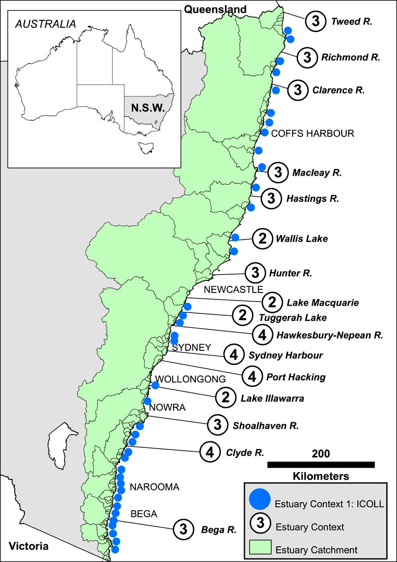
FIGURE 1. Location of estuary contexts referred to.
Different estuary and coastal water body types based on bio-physical criteria have been recognised along the NSW coast (Roy, 1984; Roy et al., 1980; West et al., 1985; Table 1; Roy et al., 2001; Hanslow et al., 2018; OzCoasts, 2019; Heimhuber et al., 2019). Initial work by Roy using geological criteria identified three main types of estuaries involving distinctive entrance conditions that control tidal drainage (drowned river valley, barrier estuary, saline coastal lake, Roy, 1984; Figure 2). The main types were later termed “tide-dominated”, “wave-dominated” and “intermittently closed” in Roy et al. (2001, p.351). They added a fourth type termed a “mature riverine estuary” based on an understanding of the infilling of a barrier estuary by river sediments during the last 6,000 years (illustrated in Roy, 1984; Figure 4; see also Roy et al., 2001; Figure 2 (b)). The three main types were also used by OzCoasts (2019) and Heimhuber, et al., 2019, Figures 8–10) under the general term of “tide dominated” to distinguish them from an “oceanic embayment” or open bay estuary. The saline coastal lake/lagoon of Roy is now more widely termed an ICOLL (“intermittently closed and open lake and lagoon”; see Haines et al., 2006; New South Wales Government, 2020). Hanslow et al. (2018) used this term as one of their five different types of NSW estuaries based on tidal plane analysis (drowned river valley; large tidal river; small tidal river; tidal lake (permanent open entrance); and ICOLLs). The spring tidal range along the open coast is c.2 m declining slightly from north to south.
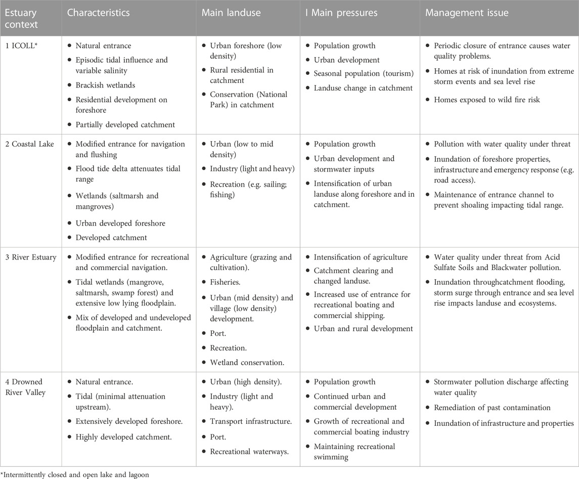
TABLE 1. Features of the four estuary contexts.
It is not the purpose of this paper to describe in any detail the bio-physical attributes of the various estuary types in NSW. This is comprehensively covered in the paper by Roy et al. (2001; see also West et al., 1985, and Williams et al., 2006, for more details on estuary characteristics). They were able to demonstrate how sedimentary environments (called zones) have characteristic water quality, nutrient productivity signatures, and ecosystems. The ecology is shown to change over time as the geomorphology evolves. They conclude that their structural/functional framework of estuarine condition offers scope to help managers “predict the biological and ecological effects of human interventions”, such as breakwaters, catchment disturbance (Roy et al., 2001, p.376). Climate change impacts can be best understood within this holistic framework reflecting the interconnectedness of bio-physical forces.
There are 55 local councils responsible for managing c. 60% of the NSW coast. Coastal settlements within these range from the large highly urbanised port cities such as Sydney, Newcastle and Wollongong which contain the bulk of the state’s population of (c.5 million) to smaller regional centres dotted along the entire coast with populations over 10,000 (e.g., Bega, Nowra, Coffs Harbour) (Figure 1). Small villages and hamlets complete a hierarchy of settlement sizes, Gurran and colleagues have examined the social and settlement structure of these so-called “sea change” communities which continue to grow in population (Gurran et al., 2008).
The estuaries of this state have long been of great cultural and economic importance (Hoskins, 2013). For First Nations people, estuaries were central to the cultural identity of coastal communities as well as providing a rich source of food and other resources to sustain their physical and spiritual wellbeing. The arrival of Europeans, with initial settlements from 1788 to around the mid 19th century, saw large estuaries (e.g., Sydney Harbour, Newcastle Harbour) become historical gateways for international migration and trade. Regional communities developed on smaller estuaries and relied heavily on coastal shipping for transport and trade of timbers and other rural produce to the major centres. Over decades an estuarine fishing industry, based on productive estuary habitats for fish, prawns and oysters, thrived and supported many regional communities. The value of estuaries as recreational places and assets also grew, supporting the lifestyles of urban and regional communities who enjoy year-round access to the multitude of waterways under the influence of warm temperate climatic conditions and the East Australian Current in the Tasman Sea.
The downside of abundant historical diversity and opportunity is a false perception of limitless abundance and resilience. The former Healthy Rivers Commission (HRC) documented how many estuaries were treated as having a “limitless capacity” to support human activities (e.g., HRC Coastal Lakes Inquiry, 2002). Sites of First Nations occupation have been destroyed, including use of their shell middens (and associated natural shell reefs) for construction lime by early colonial settlers. Such sites are lost permanently—cultural evidence cannot ‘bounce back’. Estuaries have also been treated as drains to receive discharges from intensive agriculture, contaminants from heavy industry and high nutrient flows from wastewater treatment plants.
HRC identified what it called “fundamental realities” that must be faced in any effort to improve the health of coastal water bodies that had been adversely impacted by historic and ongoing pollution, reclamation, entrance modifications and shoreline development. State of Environment reports by the Australian Government continue to lament the health of the nation’s estuaries. Risks to estuary health and estuary values associated with these impacts, as well as clearance of vegetation in catchments, continued urbanisation and polluted stormwater discharges, are cumulative issues that are not easily mitigated. It is in this context of continued use and unfounded assumptions about restoration and resilience that managers are confronted with additional threats from climate change.
In a recent overview of climate change in estuaries along the NSW coast, Heimhuber et al. (2019, p.2) recognise how potential impacts of warming air and water temperatures, rising sea levels, acidifying waters and changing salinities are compounding the cumulative adverse effects of population growth and increased development. To these factors could also be added the impacts of worsening fire regimes and terrestrial flooding. They state: “To ensure that future generations can continue to benefit from the range of ecosystem services that estuaries provide, these systems need to be managed in an ecologically sustainable way”.
The following section outlines steps taken by the NSW Government to develop shared understanding and commitment to sustainable estuary health and to establish a framework to meet the challenges of the new climate era in the coastal zone.
3 Coastal zone management in NSW—institutional arrangements
Under the Australian Constitution, eight states and territories are responsible for land use planning and coastal management policies and legislation (Harvey, 2016). The national government historically has had limited and episodic involvement in coastal management, leaving the states and territories to develop their own and different approaches to managing their coasts. Consequently, coastal legislation in Australia is state/territory-led, non-uniform, and has produced varying, inconsistent and potentially conflicting approaches to coastal zone management and climate change adaptation (Harvey and Clarke, 2019).
For the state of New South Wales, the history of coastal management policy can be characterised as one of successive state and local governments episodically responding to destructive storm events since the late 1960s, with short term and uncoordinated programs that lacked accountability. The emerging effects of climate change are compounding the pressures on the coastal zone and highlighting the critical importance of strengthened strategic, adaptive and integrated approaches.
By 2014 it was widely recognised that existing arrangements for coastal management and land use planning under the NSW Coastal Protection Act 1979 and companion Environmental Planning and Assessment Act 1979 had become complex and difficult to apply. A new phase of coastal reforms acknowledged that existing arrangements were no longer fit-for-purpose. Legislation and policy had failed to reduce risks in the current context and were not designed to meet the pressures and challenges of climate change. The state government set out a coastal reform agenda which would address.
• Regulatory complexity—decisions involved multiple interactions between land use planning legislation, local government policy and plans, state environmental planning policies, plans of management, masterplans, Ministerial directions and statutory guidelines. While regulatory complexity also applies to other landscapes in NSW, the high population and development pressures in the coastal zone require local councils to consider highly complex analysis, often with limited quality data inputs, when making land use and land management decisions;
• A lack of strategic land use and local government planning - the emphasis on regulating impacts at development assessment scale for individual properties, or groups of properties, had proven inadequate to the challenge of integrated management of the coastal zone;
• Prioritisation—local councils do not have care or control of the whole coastal zone. There has been a disconnect between local government coastal zone management planning and financing and other council priorities and services, as well as inconsistencies between local councils and state agency priorities; and
• Ongoing unresolved legal issues for land tenure and property boundaries subject to coastal erosion and accretion (Corkill, 2013).
New legislation was passed by the NSW Parliament in May 2016. The legislation was delivered as part of a broader Coastal Management Framework (the framework) which comprised six components.
• Coastal Management Act 2016(CM Act)
• State Environmental Planning Policy (Coastal Management) 2018 (CM SEPP) (now part of the Resilience and Hazards (RH) SEPP 2022)
• NSW Coastal Management Manual 2018 (the Manual)
• NSW Coastal Council (Coastal Council)
• Coastal and Estuary Grants Program (C&E Grants Program)
The CM Act also supports the management of coastal waters under the Marine Estate Management Act 2014.
The framework applied new thinking in three areas.
• First, bringing science into legislation. Coastal sediment compartments (incorporating open coast and estuary sedimentary processes) become a fundamental consideration in strategic coastal management where coastal processes, rather than local government administrative boundaries, could influence CMP planning. Further, considering the effects of climate change (CM Act Object ‘g’), and specifically incorporating impacts of climate change on wetland boundaries (CM Act s8), demonstrated state government understood the significance of placing into law consideration of emerging changes in environmental conditions.
• Second, recognition of discrete management areas within the coastal zone (CM Act Part 2). The CM Act recognises the coastal zone is not one uniform strip of land next to the sea and defines a “coastal zone” as made up of four coastal management areas: coastal wetlands and littoral rainforest area; coastal vulnerability area; coastal environment area; and coastal use area. Although these management areas may overlap, linking land use development controls to specific objectives for each of these areas is provided for in the SEPP; this allows for better alignment of coastal management objectives and land planning decisions.
• Third, a strategic role for a new Coastal Council to provide independent expert advice to the Minister, including an audit role of CMPs as directed by the Minister. Priorities for the Coastal Council’s advice are set by the Minister responsible for the CM Act in an annual work plan.
The framework represented a clear shift in government policy with a move away from site-specific and reactive coastal management under the previous legislation to a more integrated and strategic approach to coastal zone management to be delivered primarily by local government through their long-term Coastal Management Programs (CMPs). In recognition of significant changes for local government under the new framework, the state government established a Coastal and Estuary Grants Program to provide technical and financial support of AUD$83.6 million over 5 years to councils, to prepare and implement new CMPs.
The framework commenced in April 2018 with the making of the CM SEPP (now RH SEPP) and the gazettal of the Manual. Under the new framework, councils are to prepare CMPs. CMPs set the long-term strategy for the coordinated management of their coastal zone, consistent with the objectives of the Coastal Management Act 2016 (s3) and the specific requirements to consider the current and future impacts of climate change. Guidance on the preparation of CMPs using a staged risk management process is described in the new Coastal Management Manual.
The Coastal Council has undertaken annual surveys of coastal managers and practitioners since 2018 (New South Wales Government, 2018; New South Wales Government, 2020; New South Wales Government, 2021; New South Wales Government, 2022), with the latest survey completed in December 2022. The surveys track the progress of the framework to understand the issues with its implementation for professionals working in state and local government, industry, and research sectors. Similar surveys of coastal practitioners in other jurisdictions show governments grappling with the same challenges (Elko and Briggs, 2020).
The Coastal Council surveys show coastal practitioners struggle with the technical challenges of assessing the long-term effects of climate change on coastal vulnerability. Furthermore existing governance arrangements are not always suited to managing the many intersecting and often competing interests of stakeholders. This is particularly the case for estuaries. State government modelling has shown the climate change-related risks to coastal development in the state’s estuaries is of the order of tens of thousands of properties, at least an order of magnitude greater in terms of properties at risk on the open ocean coast (Kinsela et al., 2017; Hanslow et al., 2018). The need to find ways to address such challenges is quite real.
4 Estuary contexts and social-ecological systems in NSW
By adopting the concept of a “social-ecological system” of Glaser et al. (2008), we can focus on those estuaries where pressures from human activities in low-lying areas fringing estuaries are most manifest, and by corollary where most economic and social resources are at risk to forces of climate change. According to these authors, a “social-ecological system” consists of a “bio-geo-physical” unit along with its associated social actors and institutions. They are seen as complex entities delimited by spatial or functional boundaries that can be the subject of adaptive management actions. Our work has highlighted the value of defining a particular scale at which effective governance should occur.
Table 1 summarises the characteristics of the four distinct “Estuary Contexts” all of which are under pressure from continued development and impacts of climate change. Using these contexts, differentiation of the distinctive governance arrangements reflecting relationships between communities and local and state government can be characterised and appropriate management actions identified.
4.1 Estuary context 1: intermittently closed and open lakes and lagoons (ICOLLs)
ICOLLs are coastal lakes and lagoons that alternate between being closed or open to the sea. As a consequence, they can experience a wide range of salinities (Roy et al., 2001). A closed ICOLL occurs when a beach berm has built across the entrance. This allows lake levels to oscillate with variation in rainfall and evaporation. Under natural conditions the berm may break down during a flood event as water levels rise towards the berm crest. The resulting spill over creates a scoured channel. Channel depth and width may be reinforced by wave run-up and surging. Tidal exchange can then take place although the range can be attenuated due to presence of sand shoals that form a flood tidal delta The next phase of the open-close cycle occurs as flood discharge abates and wave action pushes sand shoreward to remake the berm. Of the c.90 ICOLLs it is estimated by NSW Department of Primary Industry that 70% are mostly closed (see also New South Wales Government, 2020 –tool kit). A more recent analysis of inlet state behaviour using novel statistics shows that ICOLL sites with medium to high variability are most sensitive to climate change (Garrett, 2021).
In its assessment of coastal lakes, the Healthy Rivers Commission (HRC) identified 50 ICOLLs as in either a “healthy modified condition” or required “targeted repair” (HRC, 2002, Table 6). Their report did not consider climate change factors; however, the HRC classification of these lakes has been incorporated into current NSW policy (see Schedule 2, Coastal Management Act 2016). This means that in applying the objects of the Act and the 2018 Coastal SEPP, consideration must be given to climate change forces such as sea-level rise in assessing development applications.
Physical processes that create risk to property around the shores of ICOLLs come from both the sea and the catchment. Low-lying lands can be inundated by freshwater floods when the beach berm at the entrance of the lagoon blocks exchange with the sea, or flooding can result from wave surges pushing through an open mouth, or a combination of both (this occurred in April 2022 at several ICOLL locations). Such events can adversely affect water quality especially if sewage is released from properties.
Where the catchment of ICOLLs is urbanised, and especially where homes have been located along the foreshores, community pressure often leads to manual opening of the sand berm at the entrance. Properties that lie within an envelope defined by the height of the berm and the water level of the lake as influenced by river discharge are at risk of being inundated. Hanslow et al. (2018) using data from measurements of many NSW estuaries showed that this level could reach as high as 2.3 m above High Water Solstice Springs (HHWSS), although during extreme river floods the water level can go much higher (over +3 m HHWSS). Threats to landowners have led to local councils establishing “trigger levels” that once reached allows council to manually open the lake enabling those located close to the edge of the lake to not endure inundation.
Difficulties arise in deciding what is the most appropriate trigger level, when and even who can activate action, how to manage other consequences not related to the landowners’ objectives, and who will pay. There are also government demands on councils requiring permits from state agencies to undertake any dredging to open a lake. Agencies can have statutory responsibilities in managing the health of aquatic ecosystems. Although some local councils have management plans and agreements in place with agencies, questions still arise as to how best to implement the plans. Local communities in areas under threat from inundation may seek “simple” solutions such as building breakwaters that would ensure the entrance remains permanently open. This can be a very costly solution and is very contentious especially as sand transport by waves will soon be sequestered back into the channel requiring further dredging (or extension of the breakwaters), with significant ecological consequences.
Rising sea levels and possible changes in wave and rainfall conditions must now become part of the management plans for urbanised ICOLLs. We are conscious of continuing pressure on councils to allow more development around ICOLLs. They are very attractive places to live. But councils must juggle the various interests of state agencies such as Fisheries, Planning, Crown Lands, NPWS and Environment who may have their own strategic programs and “plans of management” for land and waterways that are their responsibility.
The challenge for local government under the CMP process is how to provide the lead and drive coordinated responses to the conflicting interests, while maintaining reasonable opportunities for landowners to use and develop their properties. Building awareness of the adaptive strategies to climate change is also required and can face opposition from some residents. Fortunately for this Estuary Context, most ICOLLs and their catchments fall within a single local government area (LGA); however, a local council may have several ICOLL sites within its area each with its distinctive attributes and pressures requiring resolution.
Staff in councils often rely on external assistance to assess risk, including how to apply climate projections and extreme event forecasts. The funding base for local government is often not adequate to employ in-house specialists, and they must largely depend on grants to engage consultants for short periods. State Government currently provides support for councils through a network of regional teams who provide advice on the best use of ICOLL science and policy and assist with the communication and transfer of lessons learnt in an adaptive process. Annual surveys of coastal practitioners highlight the opportunity to enhance this support through initiatives like prioritised access for councils to skilled and experienced staff in State Government.
This initiative would assist councils and their consultants apply a consistent approach to critical management problems such as continued development on lands subject to present and future inundation (e.g., within 5 m of HHWSS) and entrance opening regimes. The aim would be to achieve application of a land use planning policy framework that requires consistent assessment of risk in areas vulnerable to coastal hazards including those linked to climate change. Lessons learnt from research such as that by Garrett (2021) indicate the importance of maintaining an active research program that can guide decision-makers in these uncertain times.
4.2 Estuary context 2: coastal lakes with modified entrances permanently open to sea
Prior to construction of entrance training works these lakes have historically experienced infrequent closure at the entrance due to sand bar shoaling. In this way they have once behaved as ICOLLs. Most of these lakes are much larger in area and volume than the typical ICOLL discussed above. They are also much more modified systems. Examples are Wallis Lake, Lake Macquarie, Tuggerah Lake, and Lake Illawarra (see below for case study of Lake Macquarie).
The State Government has been involved in the design and construction of the rock breakwaters for all except Tuggerah Lake where it has assisted the local council with dredging (to improve water quality). Lake Macquarie is the only one of these urban coastal lake systems where regular dredging and training walls are intended to enable safe and reliable navigation by deep keel recreational vessels. However, the works have unintended consequences (see below) and have not satisfied all waterway users. Smaller examples of navigable trained entrances are located in rural areas such as Narooma on the NSW South Coast and near Laurieton on the North Coast.
Estuary Context 2 represents large coastal water bodies around which there has been considerable urban and, in some cases, industrial development. Lake Macquarie, Lake Illawarra and Tuggerah Lakes provided cooling water for coal fired power stations for decades, with impacts on estuary circulation and temperature. All these systems historically received both urban stormwater and effluent discharges from wastewater treatment works (or septic tank systems).
Typically, coastal lakes contain areas of long-term residential development. Local communities value the lakes for fishing, swimming, boating and sailing. Lake communities are very conscious of water quality issues and sedimentary processes that affect waterway use and amenity. These large lakes are important local employment generators through regional waterway tourism.
Notwithstanding communities valuing ‘clean’ water suitable for recreation, urban development around the shores and in catchments has historically affected water quality, leading to community pressure for entrance training works (particularly in Tuggerah Lakes and Lake Illawarra). Some residents believe a trained entrance will help flush out pollutants and allow permanent tidal exchange. They also believe that frequent dredging of entrance shoals to deeper depths will improve circulation and water quality. A perceived bonus is that dredging will enable larger vessels to navigate the entrance, but this aim and associated costs are not shared across the whole community. Significant levels of community, council and agency distrust and conflicts about management decisions and priorities are common in these systems, reflecting their high lifestyle value, diverse objectives and complex system responses to intervention.
Large coastal lakes have several distinctive water level characteristics and processes which influence their distinctive but uncertain response to sea-level rise and climate change. These include.
• Tidal delta shoals attenuate tidal range quite significantly. Tidal plane analysis by Hanslow et al. (2018) demonstrates a rapid decline in tidal elevations from 1 m HHWSS at the mouth to a narrow envelope around c.0.3 m over the vast area of the lake once the threshold of the landward end of the flood tidal delta is passed. Deepening the entrance channel through dredging can reduce attenuation effects and thus increase tidal elevations. Lake tides are not synchronous with ocean tides, resulting in complex patterns of water level.
• Wind waves become important in shoreline development where there are exposed long fetches.
• After heavy rainfall events, freshwater inputs from the catchment may be trapped within the lake through several tidal cycles, with impacts on water quality extending over weeks and even months. Conversely, plumes of sediment laden water from lake catchments do make their way to the ocean and impact on nearshore water quality.
• Recent work has indicated that long period “coastal trapped waves” (CTW) travelling north along the east coast can penetrate the deeper waters of these lakes (D. Hanslow, p. comm.)). These are associated with extreme rises in water levels of the order of 40–50 cm leading to inundation of low-lying areas and foreshadowing future risks from sea-level rise.
Detailed modelling of the Swansea Channel (the entrance channel of Lake Macquarie) provided a methodology to examine uncertainties associated with sea-level rise (in addition to any dredging). This work demonstrated changes in water surface elevations in both time and space from various causes, assuming increased hydraulic efficiency afforded by the deepening tidal channel leading to a larger flow volume into the main waterway of this coastal lake (Callaghan et al., 2020).
Climate change must exacerbate the impacts of human intervention to the coastal lake’s hydrology. Nielsen and Gordon (2008) have examined the hydraulic stability of entrances and shown how entrance breakwaters produce an unstable scouring mode for decades. They show that it will take centuries for these entrances to reach a new hydraulically stable regime with the consequence that extensive protection works are needed, and permanent changes will occur to fringing ecologies. Rising sea levels can only add to the uncertainty not just in raising ocean water levels at the entrance, but in how additional sand may ingress into the entrance and onto the flood tidal delta from erosion of adjoining sand barriers. Modelling these complex morphodynamic feedbacks is difficult at this stage.
Local councils are very conscious of the need to mitigate pollution and maintain a healthy waterway. They are also aware of potential impacts of sea-level rise on vulnerable communities living on low lying land. Councils have tested several governance and management models to optimise ongoing interaction between local communities, local government, coastal scientists and state government agencies needed to address the specific challenges of Type 2 estuaries. Annual surveys of coastal practitioners highlight the difficulties for councils where state agency guidance or support is delayed. External reviews of Lake Illawarra (2002) and Tuggerah Lakes (2020) have offered solutions to these problems, with the recent Lake Illawarra Coastal Management Program (Wollongong and Shellharbour City Councils, 2020) a contemporary example of a successful collaboration between councils and State Government to deliver a long term management strategy for the lake. Fortunately, Estuary Context 2 sits primarily within the control of a single LGA, so coordination with multiple local councils across a lake and its catchment (as required under the Coastal Management Act 2016) is not the key governance issue. However, the complex interacting values and pressures on urbanised coastal lakes mean there are multiple state agencies with interests, objectives, priorities and obligations which may not be consistent with the perspective of the local council and its community. Local councils, for instance MidCoast Council, are now very active in bringing agency interests together to help solve specific lake management problems such as entrance shoaling.
The success of the Lake Macquarie Task Force 1998–2008 offers a template for coordinated management (see below). Given the economic importance of these large lake systems, it is suggested that a similar model involving senior regional representatives of agencies should be permanently established to assist councils deliver on the objects of legislation relevant to maintaining and improving lake health. We recognise the occurrence of vulnerable communities living on low-lying land around coastal lakes subject to both tidal inundation and catchment inundation, without management interventions, sea-level rise will make these areas uninhabitable. The current NSW coastal management framework has brought state agencies responsible for science, land use planning and emergency response into a risk assessment and mitigation process with local councils with the aim to secure implementation of agreed actions, including actions to reduce uncertainty and provide for accountability.
4.3 Estuary context 3: river estuaries
From the south of NSW into Queensland several large rivers drain the uplands of the Eastern Highlands. These rivers discharge directly into the Tasman Sea, exiting via an entrance that is morphologically constrained by beach and dune deposits forming coastal sand barriers (Roy, 1984). A common attribute of this Estuary Context is the development of an extensive deltaic flood plain at low elevations subjected to tidal influence and periodic freshwater flooding. Tides can penetrate as much as 50+ km upstream from the river mouth maintaining close to the tidal range of the entrance to the sea (Hanslow, et al., 2018).
Roy and others since the late 1970s have demonstrated how these flood plains have progressed through several stages of barrier lagoon infilling into a “mature riverine estuary” since sea level has been around its present position (Roy et al., 1980; Figure 4; Roy, 1984; DPIE, 2004; Roy et al., 2001; Figures 2, 5). The process of infilling follows a pathway of shallowing of estuarine muds that have been deposited by rivers in the mud basin of the lagoon to intertidal elevations at which point alluvial deposition takes over. Channels form as part of a fluvial system characterised by levees and backswamps. Alluviation raises the elevation of parts of the flood plain above HHWSS but leaving large tracts still within the tidal range (Waddington et al., 2022). Flood plain estuaries occur in catchments such as Tweed, Richmond, Clarence, Macleay, Hastings, Hunter, Shoalhaven, and Bega rivers (Figure 1).
These big river systems have traditionally supported productive estuary fisheries, oyster industries and floodplain agriculture. The channels have been deep enough in the past to enable the establishment riverside ports for ships entering the sea through trained entrances involving trade in forestry and agricultural products (Coltheart, 1997). Historically, the floodplains were also areas of high biodiversity, with a complex pattern of wetlands, swamp forests, dry forest and rainforest providing habitat for large populations of reptiles, migratory and resident birds and marsupials.
In all these examples low-elevation lands of flood plain estuaries have been essentially cleared and drained since the mid to late-19th century, with the intent of improving productivity for agriculture. Many freshwater wetlands were drained, and flood mitigation channels dug to alleviate the impacts of flood inundation. Tidal incursions into backswamp wetlands are often controlled by flood gates. The aim was to use gravity to help discharge waters off the land by drainage at low tide. As discussed in detail by Waddington et al. (2022), it is the tidal range of 1 + m, and the semi-diurnal duration of rising and falling tides, that provides a window of opportunity for gravity discharge. The drainage system is particularly sensitive to changes at low tide levels, highlighting the vulnerability of these low-elevated lands to rising ocean sea levels driving changes to the tidal regime.
Another factor associated with the construction of drains on these flood plains has been the exposure of estuarine muds beneath the thin alluvial cover. This has led to oxidation of sulfidic compounds in the muds (acid sulfate soils or ASS). Over the last 30 years much research by academics and government agencies has been undertaken on problems associated with acidification of former freshwater wetlands on these flood plains (Tulau, 2007; White et al., 1997; Sammut et al., 1996). ASS drainage (and also low dissolved oxygen or ‘blackwater’ events) has adversely impacted estuary health resulting in fish kills, degraded aquatic habitats, and reduced farm values.
A threats and risk assessment (TARA) of the NSW Marine Estate identified polluted agricultural runoff under such conditions as detrimental to the social, environmental, and economic wellbeing of these areas. Since the 1990s, the NSW Government has recognised that mapping areas that contribute most to the generation of acid (and other pollutants) is an important step to guide future investment and overall management of coastal flood plains. However, such understanding now must incorporate the changing dynamics of the new climate era as sustaining healthy water quality in the long-term is critical to future land uses of these flood plains.
Recent studies undertaken on behalf of the NSW Government of all the major floodplain estuaries by the Water Research Laboratory (WRL), University of NSW, have developed a prioritisation process to establish which sub-catchments of these flood plains must be targeted for on-ground management actions including remediation. The aim is to identify locations that are sources of poor water quality (M. Riches, p. comm; see Glamore and Rayner, 2014; Glamore et al., 2016, for early examples of this work applied to the Shoalhaven River and Manning River drainage areas). This work also identifies low risk/priority floodplain areas that can guide land managers and decision makers in implementing on-ground actions. Some actions may be implemented without significant impacts to existing land uses, while others require changes driven by both the need to improve water quality outcomes and, importantly, to be cognisant of the effects of sea-level rise. Waddington et al. (2022) discusses these issues in two areas: Clarence and Hastings flood plains. What they show is the importance of assessing local inundation effects not just as high tides get higher, but also the effect of higher and higher low tides. These authors have identified a “drainage window”, a concept that examines how present-day and future SLR regimes may influence drainage effectiveness of different estuarine flood plains. They also show how SLR may substantially reduce the opportunity for discharging water off many estuarine floodplain drainage systems. This will progressively lead to problems for those seeking continuation of present-day land-use practices, especially as the drainage window effect reduces the capacity of flood gates to function. As a result, low-lying areas cannot be effectively drained and will become increasingly wetter. The advantage of this work is that it provides a detailed assessment of floodgate and floodplain vulnerability of drainage infrastructure and its drainage potential for present-day, near-future (2050), and far-future (2,100) planning horizons.
It is apparent that sufficient information now exists for these major estuary flood plains to inform the strategic planning that is required to address the multitude of vulnerabilities existing in these estuary systems. There are huge implications for existing land holders and local councils as to how to best adapt to the threats to livelihoods resulting from both degraded ASS lands and inevitable progressive impacts of SLR on flood plains. In addition, all these flood plains will periodically experience extreme freshwater flooding of magnitude similar, if not greater, to that of February 2022 (in the Tweed, Richmond and other systems).
Both extreme catchment flooding events and long-term tidal inundation also have significant risk implications for productive aquatic resource use such as fishing and oyster farming. This will involve understanding how current connections of artificial and natural waterways will operate under climate change. Other assets at risk include town water supplies that are protected by low weirs (such as in the Tweed River), which are rarely overtopped by tidal water now, but events are expected to become more frequent and have longer duration in the future.
Land use transformations that are foreshadowed as part of any adaptation process will affect community structure, economic and social wellbeing. Examples of the magnitude of the risks have been revealed in government reviews of river floods of 2022. Many of the findings of these reviews appear relevant to impacts of sea-level rise on estuary water levels and periodic extreme oceanic events that penetrate estuaries. Research by Lee et al. (2017) on impact of sea-level rise on tidal range in Chesapeake and Delaware Bays points to adaptation strategies that allows inundation over low-lying areas to reduce tidal range in up-estuary locations. The alternative of harden channel banks could potentially lead to further tidal amplification. It is through understanding such effects that adaptation planning will benefit.
The CMP approach under the NSW Coastal Management Act 2016 offers scope for addressing the strategic planning process required on coastal flood plains. At one level the agencies involved recognise that CMP development offers a process for strategic planning. It may be easier where there is a single local council involved (e.g., Shoalhaven, Manning, Macleay, Hastings, Clarence, Tweed). This is not always the case (e.g., Richmond, Hunter).
Coastal practitioners consistently raise in annual surveys the challenges of achieving agreement within and between agencies and in communicating outcomes of these agreements to land holders and community groups. Estuary Context 3 requires a governance model that can develop adaptive pathways that may lead to more nature-based (blue carbon) opportunities where they are economically and socially acceptable. However, the complex mix of private and public interests in land and water use of this estuary context will make permanent governance structures hard to establish. Models are being developed in the Richmond Valley Partnership and the Hunter River Estuary Alliance although it is still early days. Annual surveys highlight the need for a high level of trust in the communication of respective interests of both private and public sectors if these vast floodplain estuaries are to be managed in ways consistent with legislation, especially provisions of legislation which embraces the need to plan strategically for the new climate era.
4.4 Estuary context 4: urbanised drowned river valleys
Several drowned river valleys with permanent connections to the sea are located on the mid NSW Coast and South Coast. They include the Clyde River, Port Hacking and Hawkesbury-Nepean River. However, only one has a deep enough entrance for large ships to enter and dock: Sydney Harbour, otherwise known as Port Jackson. This estuary is distinctive given its national and international importance and its various economic, social and environmental values. Several of its attributes apply to the other drowned valleys in that they are tidally flushed, fed by freshwater flows, but with salinity regimes that are well mixed.
The Sydney Harbour estuary occupies a dendritic bedrock valley system carved into rocks of Mesozoic age. Many bays within the estuary are steep-sided. Low-lying lands are confined to heads of these bays or are reclaimed lands. As much as 11 square kilometres of the Harbour are the product of land fill (Birch, 2009). While its geologic history is complex, many of the sedimentological attributes described by Roy for other estuary types can be found in this estuary (Roy, 1984). Birch and Lound (2021) have recently provided a more detailed account of the Late Quaternary geological history of the lower (seaward) section of the estuary.
The estuary stretches 30 km inland to Parramatta with its catchments covering 470 km2 of highly urbanised land embracing a population of c.3 million. It is the economic hub of NSW containing three CBDs within its area (Sydney city, North Sydney, and Parramatta). A wide mixture of land use types (e.g., urban, commercial, industrial, parkland) occurs within its catchments. Although much of its topography lies outside land which is inundated by flash flooding or extreme high tide events (so-called “king tides”), the area is subject to impacts of climate related events including heat, bushfires, water restrictions, extreme rainfall events and sea-level rise (Hague et al., 2020). It is anticipated that these impacts will grow in intensity over the next 100 years. There is the possibility of tidal plane amplification as sea level continues to rise in this estuary (W. Glamore p. Comm; see Khojasteh et al., 2021).
The Sydney estuary is subject to continued population growth and development, legacy issues of aging sewer and stormwater infrastructure, and a history of contaminated low-lying lands and discharge of pollutants into the waterways. All these factors are threats to waterway health. Climate change adds another dimension to the threats. The question Sydney estuary faces is how best to provide an integrated strategic approach to the management of compound forces at play which will potentially multiple over time. At present there is no coordinated governance mechanism in place that can efficiently consider the long-term consequences of pressures facing this estuary system. Past attempts have failed (Dawkins and Colebatch, 2006). One reason is the complexity of institutional arrangements. There are 21 local councils in the catchment area. In addition, many state and federal government agencies have direct responsibilities for aspects of the system with no legislated regional entity to take overall responsibility for ecosystem and waterway health.
An assessment of the need to find a more effective way to collectively manage waterway health is currently underway. The Coastal Management Act 2016 provided an avenue by which this assessment has been initiated. This legislation allowed for the first time for all councils and relevant state agencies to collectively work on early stages of a catchment-wide program to achieve a system-wide understanding of waterway health and assets and other interests at risk from climate. Fortunately, Sydney Harbour possesses a rich source of information on many attributes required for modelling risk and developing adaptation pathways (e.g., long tidal records at Fort Denison, Watson, 2022). Tapping into this knowledge for purposes of strategic planning that will benefit all interests is a major challenge given the absence of any coordinating authority. Such planning would also benefit other drowned river estuaries lacking in some of the background information of the Sydney Harbour estuary.
5 A model for managing climate risks in NSW estuaries: Lake Macquarie
The following case study provides a model of how a local council has sought to overcome the barriers to effective estuary management, applying different technical, communication and governance approaches to the interaction of biophysical and social-economic vulnerabilities in the NSW coastal zone.
Lake Macquarie is an example of Estuary Context 2—a large coastal lake with an urbanised catchment and engineered ocean entrance (including training walls and a dredged entrance). Although the lake and its catchment lie within two local council areas, Lake Macquarie Council covers most of the area.
Management of the Lake Macquarie estuary illustrates two governance and funding models, each implemented over an approximately 10-year period. These two governance models address different aspects of the collaboration necessary to mitigate climate change risks in complex estuary systems.
The first, implemented over a decade from 1999 to 2009, was a formal state and local government partnership. It commenced with the inquiry and report of the Premier’s Taskforce into Lake Macquarie, which led to the establishment of the Office of the Lake Macquarie and Catchment Coordinator to manage the Lake Macquarie Improvement Project. The implementation project was a joint initiative and partnership between Lake Macquarie City Council, (then) Wyong Shire Council and the NSW Government, with funding invested by all three partners.
Importantly a Lake Macquarie Project Management Committee to oversight the project was appointed by the Minister for Land and Water Conservation. The committee included representatives of both local councils, community members, regional directors of relevant State agencies and three ex officio expert appointment. The State agencies (Department of Environment and Climate Change, Department of Primary Industries, NSW Maritime Authority and Hunter Central Rivers Catchment Management Authority) brought diverse interests and objectives to the project. The Management Committee was further informed by a community-based Estuary and Coastal Management Committee.
Important features of the governance arrangements during this period, which helped overcome barriers to coordinated management, improved estuary health and delivered stakeholder experience of partnership-style engagement and accountability, included.
• The oversight Lake Project Management Committee was directly appointed by the responsible Minister, providing a direct accountability process for the objectives of coordinated problem solving and action
• There was upfront agreement about funding for program implementation, with a total of $20 million from state and local government, The local government contribution was enabled by Treasury agreement to a local government levy, which allowed the councils to match the funds invested by the State Government directly through Treasury.
• The project budget was managed by the Office of Lake Macquarie and Catchment Coordinator (OLMCC), with delegation and flexibility to manage the program to deliver the required lake health outcomes.
• All key state agencies were represented at regional director level, providing a forum to resolve different objectives and priorities and ensuring appropriate resources were made available at the regional scale
• The model recognised that progress was critically dependent on engaging the community in decisions and accountability
• The appointment of expert advisors strengthened communication between community representatives and the public authorities. This was supported by community engagement specialists from within the councils
• In parallel with the State government collaboration, the 1999–2009 project was enabled by strong council investment in community awareness, engagement, commitment and action. An example was Lake Macquarie Council’s support for Landcare volunteers, with more than 260 Landcare groups operating across the city during the period of the OLMCC. Landcare and other community groups are ambassadors for sustainability and for change to mitigate climate risks.
Since the completion of the 10-year Lake Macquarie Improvement Project, estuary management programs have continued to be delivered, with projects managed by the two local councils and relevant State agencies. While some of the close collaboration, fostered by Ministerial direction, has declined, the second decade of management has provided opportunities to test new models of agency coordination and shared decision making with local communities, as seen in the Lake Macquarie Coastal Management Program (Lake Macquarie City Council, 2023). These models have been tested in the context of increasingly certain evidence of climate change signals in lake systems.
Council has benefitted from the flow-on effects of the previous close working relationship. This is in part enabled by the estuary being in a region where there has been relative continuity in public authority staffing. There is a strong benefit from a history of working together in a positive process. Generational change across councils and agencies creates new challenges for long standing interagency relationships.
To a large extent Lake Macquarie City Council has lost the independent project management framework that was a feature of the Lake Improvement Project, with funding for lake management now mostly dependent on annual grant programs. This increases uncertainty about funding partnerships and reduces capacity to solve strategic issues in an integrated and programmed way.
Council has moved to further strengthen community involvement in decision-making about high-risk issues in Lake Macquarie. It has completed two local adaptation plans with communities living on low lying land on the eastern shore of the estuary, and subject to mid-term tidal inundation as well as catchment inundation. These Local Adaptation Plans (LAPs) were for Marks Point (population approximately 2000, living on back barrier flat) and then Swansea/Blacksmiths/Pelican (population approximately 5,000, living on flood tidal delta, back barrier flat).
Both projects used a fully collaborative project structure where community representatives are members of the Project Steering Committee and have power in decision making. This approach enhances resilience. It recognises the value, identified in the literature for complex estuary management issues, of a project structure that facilitates councils listening to all voices and perspectives throughout the evidence gathering, option evaluation and decision-making process and providing regular feedback to community stakeholders using clear community focused language. This is particularly valuable where the mitigation of risks requires a significant change from the land use status quo.
In the Lake Macquarie case, the collaborative engagement process used in developing the LAPs has.
• Enabled community input in terms of lived experience and local observations
• Facilitated transparency about science, monitoring and modelling, and uncertainty
• Raised community awareness of risk assessment and mitigation processes, and how risk is influenced by exposure to hazards, likelihood, and vulnerability
• Enabled discussion of risk tolerance (e.g., how many inundation events, for what duration and at what depth)
• Involved residents in discussion of adaptation measures, timeframes, and trade-offs, including the adaptation capacity of intertidal wetlands, whether wetlands offer a feasible inundation buffer for residential and commercial development, how and when fill would need to be placed and implications for community cohesion and amenity
• Enabled community acceptance of a program of risk mitigation, with identified thresholds and triggers for changes to risk management strategies as new evidence becomes available.
The LAPs will assist the council in finalising its Coastal Management Program. They offer an excellent process for building a more strategic approach from specific local studies in areas that are of great local concern.
6 Discussion and conclusion
A question that was posed by Wolanski and Ducrotoy (2014) is whether Australia’s growing human population and economy will be compatible with environmentally sustainable conditions for its estuaries and coasts by 2050. In answering that question, a key consideration is whether our management approaches are fit for purpose for mitigating risks posed by the threats associated with climate change, especially on low-lying lands bordering the nation’s populated estuaries. These are matters that have global implications.
Our thesis is that distinctive social-ecological estuary contexts identified in the NSW coastal zone are relevant to future strategic planning and governance arrangements to achieve resilient coastal systems and coastal communities. Importantly, the character of these estuary contexts points to key features of governance models, coordination and communication that are required for successful delivery of resilience and sustainability outcomes.
Risks to the health and sustainability of these systems vary with the biophysical character of the estuary system, the pressures arising from historical and on-going development activity, and with community vulnerability or resilience capacity to future threats. The diversity of estuary contexts in NSW is an example of what other nations face demanding diverse response frameworks, especially at a time when climate change knowledge and impacts become more apparent.
On the bio-physical character side, various estuary systems are affected by different combinations of compounding and cascading hazards. Some systems are more likely to be affected by severe compounding hazards such as intense rainfall, storm surge and high winds while other systems retain extensive wetland shorelines which can protect development from inundation, erosion or channel change. Wildfire in catchments can add to adverse effects on both people’s lives/property and waterway health, a compounding effect (Birch and Taylor, 2004).
Different social and economic context also create differential vulnerabilities and capacity to adapt. Risks are increased in communities which do not have existing capacity to predict, communicate, work together, make decisions and respond. These vulnerabilities may be associated with poverty, poor educational background, migrant or non-English speaking communities, communities with a high turnover of residents, elderly communities or communities dependent for employment on industries that are also vulnerable to coastal hazards. Use of the Estuary Context approach allows scope for managers to better understand those differential vulnerabilities and adaptation capacities through appreciation and communication of the distinctive ways bio-physical forces behave. This was clearly shown in the case study of Lake Macquarie which demonstrates a scale of governance that addresses environmental, social, economic and political considerations within a defined bio-physical system.
The NSW Coastal Management Framework places local councils at the centre of the development and implementation of coastal management programs, designed to address the strategic risks that arise from the complex interactions of hazards, threats and vulnerabilities. Although local councils have this central role, effective CMPs depend on the co-operation and collaboration of state agencies and the engagement of local communities, through all stages of information sharing, objective setting, planning, option evaluation, decision making and priority setting, implementation, monitoring and review. This is an on-going challenge. Climate change forces, especially SLR, demand new ways for both public and private institutions, and communities to collaborate. The NSW Coastal Management Framework offers opportunities to meet the challenges. Future auditing, as required under legislation, will monitor problems of implementation. Applying this framework should assist councils and state agencies determine more clearly levels of risk (high, medium, low) facing them as they develop adaptation pathways defining actions to be taken to mitigate specific risks.
To date detailed feedback from local councils to the NSW Coastal Council as part of the Council’s annual survey process shows that successful management of complex estuary issues and risks is encumbered to a degree by inadequate communication and information sharing between levels of government (and even within branches of local government). A communication gap still exists to a degree between scientists and communities that struggle to adjust to longer-term strategic planning where uncertainty in climate forecasts persists. There is an on-going need to educate and assist state and local government staff responsible for delivery of outcomes to communities highlighting capacity limitations at all levels.
Any ambitious change to governance arrangements can be constrained by levels resistance within governments and in communities. What we are attempting in NSW has its limitations at present. However, the rapid nature of climate change as well as other socio-economic dynamics in coastal areas, forces us to think of new ways to secure sustainable outcomes. The path forward will be full of potholes that must be avoided wherever possible. Embracing an approach to governance that recognises spatial scale and the bio-physical and socio-economic dimensions in an integrated way may help navigate complexities/pathways of coastal adaptation. Application of the four distinctive Estuary Contexts as shown in this paper, involves different ways to meet the threats posed by climate change through defining different strategic spatial planning and governance frameworks that must adapt to changing circumstances.
Data availability statement
The original contributions presented in the study are included in the article/supplementary material, further inquiries can be directed to the corresponding author.
Author contributions
All authors listed have made a substantial, direct, and intellectual contribution to the work and approved it for publication.
Acknowledgments
The authors would like to thank members of the NSW Coastal Council for their support and comment on the issues and management options for estuaries on the NSW coast as well as the many coastal practitioners in State and local government who provided feedback in annual surveys and other public forums since 2018. The views expressed in this paper remain those of the authors and not the NSW Coastal Council. John Hudson acknowledges the NSW Department Planning and Environment for their support of his authorship of the paper. We would like to dedicate this paper to Dr Peter Roy who provided the foundation for the study of estuary types in southeast Australia.
Conflict of interest
Author PD-J was employed by Umwelt (Australia) Pty Limited.
The remaining authors declare that the research was conducted in the absence of any commercial or financial relationships that could be construed as a potential conflict of interest.
Publisher’s note
All claims expressed in this article are solely those of the authors and do not necessarily represent those of their affiliated organizations, or those of the publisher, the editors and the reviewers. Any product that may be evaluated in this article, or claim that may be made by its manufacturer, is not guaranteed or endorsed by the publisher.
References
Birch, G., and Lound, S. (2021). The Late Quaternary geological history of the lower Sydney estuary. Regional Stud. Mar. Sci. 47, 101915.
Birch, G., and Taylor, S. (2004). “The contamination status of Sydney Harbour sediments. A handbook for the public and professionals,” in Environmental, engineering and hydrogeology specialist group (Hornsby, Australia: Geological Society of Australia). No 1.
Callaghan, D., Wainwright, D., and Hanslow, D. (2020). Consideration of uncertainty in sea level rise in Australia’s most exposed estuary: A discussion on allowances under different epistemic uncertainties. Coast. Eng. 159, 103718.
Coltheart, L. (1997). Between wind and water. A history of the ports and coastal waterways of New South Wales. Sydney: Hale and Iremonger.
Corkill, J. (2013). Ambulatory boundaries in New South Wales: Real lines in the sand. 3 Prop. Law Rev., 67–84.
Dawkins, J., and Colebatch, H. (2006). Governing through institutional networks: The governance of Sydney Harbour. Land Use Policy 23, 333–343.
DPIE, 2021. Form and function of NSW intermittently, closed and open lakes and lagoons. NSW Department of Planning, Infrastructure and Environment, Parramatta, Australia, NSW coastal manual tool kit.
Elko, N., and Briggs, T. R. (2020). National coastal management challenges and needs. Shore Beach 88 (4), 34–43.
Garrett, O. 2021. Investigating the spatial and temporal dynamics of ICOLL inlets in NSW using InletTracker. Master of Engineering Science Thesis, 20, Faculty of Engineering, University of NSW, Kensington, Australia.
Glamore, W., and Rayner, D. (2014). Lower Shoalhaven River drainage remediation action plan. Manly Vale: University of NSW. WRL Technical Report 2012/25.
Glamore, W., Ruprecht, J., and Rayner, D. (2016). WRL technical report, 2016/01. Manly Vale: University of NSW.Lower Manning River drainage remediation action plan
Glaser, M., Krause, G., Ratter, B., and Welp, M. (2008). Human-Nature-Interaction Anthropocene. Potential Social-Ecological Syst. Analysis 1, 77–80. doi:10.14512/gaia.17.1.18
Gurran, N., Hamin, E., and Norman, B. (2008). “Planning for climate change: Leading practice principles and models for sea change communities in coastal Australia,” in National Sea change Taskforce and planning research centre (Camperdown, Australia: University of Sydney).
Hague, B., McGregor, S., Murphy, B., Reef, R., and Jones, D. (2020). Sea level rise driving increasingly predictable coastal inundation in Sydney, Australia. Earth’s Future 8, e2020EF001607. doi:10.1029/2020EF001607
Haines, P., Tomlinson, R., and Thom, B. (2006). Morphometric assessment of intermittently open/closed coastal lagoons in New South Wales, Australia. Estuarine. Coast. Shelf Sci. 67, 321–332.
Hanslow, D., Morris, B., Foulsham, E., and Kinsela, K. 2018. A regional scale approach to assessing current and potential future exposure to tidal inundation in different types of estuaries. Sci. Rep. 8 (1).
Harvey, N., and Clarke, B. (2019). 21st Century reform in Australian coastal policy and legislation. Mar. Policy 103, 27–32.
Harvey, N. (2016). The combination-lock effect blocking integrated coastal zone management in Australia. Ocean. Yearb. 30, 1–31.
Heimhuber, V., Glamore, W., Bishop, M., Dominguez, G., Scanes, P., and Ataupah, J. (2019). Climate change in estuaries—state of the science and guidelines for assessment. Module 1 introduction. Available at: https://unsw-primo.hosted.exlibrisgroup.com/primo-explore/fulldisplay/unsworks_modsunsworks_61501/UNSWORKS.
Khojasteh, D., Chen, S., Felder, S., Heimhuber, V., and Glamore, W. (2021). Estuarine tidal range dynamics under rising sea levels. PloS ONE 16 (9), 0257538.
Kinsela, M. A., Morris, B. D., Linklater, M., and Hanslow, D. J. (2017). Second-pass assessment of potential exposure to shoreline change in New South Wales, Australia, using a sediment compartments framework. Journal of Marine Science and Engineering 5 (4), 61. doi:10.3390/jmse5040061
Kjerfve, B., and Magill, K. (1989). Geographic characteristics of shallow coastal lagoons. Mar. Geol. 88, 187–199.
Lee, S. B., Li, M., and Fan, Z. (2017). Impact of sea level rise on tidal range in Chesapeake and Delaware Bays. JGR Oceans. doi:10.1002/2016jC012597
New South Wales Government, (2018). Implementation of the coastal management framework – An annual survey of coastal practitioners and managers. Available at: https://www.environment.nsw.gov.au/research-and-publications/publications-search/coastal-planning-survey-summary-report-2018.
New South Wales Government (2020). Survey of the implementation of the Coastal Management Framework (December 2019). Available at: https://www.environment.nsw.gov.au/research-and-publications/publications-search/survey-review-of-the-implementation-of-the-coastal-management-framework-2019.
New South Wales Government (2021). Implementation of the coastal management framework – An annual survey of coastal practitioners and managers. Available at: https://www.environment.nsw.gov.au/research-and-publications/publications-search/survey-of-the-implementation-of-the-coastal-management-framework-december-2020.
New South Wales Government (2022). Implementation of the coastal management framework – An annual survey of coastal practitioners and managers. Available at: https://www.environment.nsw.gov.au/research-and-publications/publications-search/nsw-coastal-council-2021-22-work-program.
Nielsen, A., and Gordon, A. (2008). The hydraulic stability of some large NSW estuaries. Aust. J. Civ. Eng., 1–12. Technical Paper, 5.1.
OzCoasts, 2019. Welcome to the new OzCoasts, Available at: http://www.ozcoasts.gov.au/conceptual_mods/typology.jsp.
Rayner, D., Harrison, A., Tucker, T., Lumiatti, G., Rahman, P., Waddington, K., et al. (2021). Coastal floodplain prioritisation study—background and methodology. Australia: University of NSW. WRL Report 2020/32.
Roy, P. (1984). “New South Wales estuaries: Their origin and evolution,” in Coastal geomorphology in Australia. Editor B. Thom (New York: Academic Press), 99–121.
Roy, P., and Thom, B. (1981). Late quaternary marine deposition in New South Wales and southern queensland—An evolutionary model. J. Geol. Soc. Aust. 28, 471–489.
Roy, P., Thom, B., and Wright, L. D. (1980). Holocene sequences on an embayed high-energy coast: An evolutionary model. Sediment. Geol. 26, 1–19.
Roy, P., Williams, R., Jones, A., Yassini, I., Gibbs, P., Coates, B., et al. (2001). Structure and function of south-east Australian estuaries. Estuar. Coast. Shelf Sci. 53, 351–384.
Sammut, J., White, I., and Melville, M. D. (1996). Acidification of an estuarine tributary in eastern Australia due to drainage of acid sulfate soils. Mar. Freshw. Res. 47 (5), 669–684. doi:10.11071/MF9960669
Tulau, M. (2007). Acid sulfate soils remediation guidelines for coastal floodplains in New South Wales. New Delhi: NSW Department of Environment and Climate Change.
U.S Environmental Protection Agency (2016). Overview of the national estuary program. Available at: https//www.epa.gov/nep/overview-national-estuary-program.
Waddington, K., Khojasteh, D., Marshall, L., Rayner, D., and Glamore, W. (2022). Quantifying the effects of sea level rise on estuarine drainage systems. Water Resour. Res. 58, e2021WR031405. doi:10.1029/2021WR031405
Watson, P. (2022). Determining extreme still water levels for design and planning purposes incorporating sea level rise: Sydney, Australia. Atmosphere 13, 95. doi:10.3390/atmos130110095
West, R., Thorogood, C., Walford, D., and Williams, R. (1985). “An estuarine inventory for New South Wales, Australia,” in Fisheries bulletin No. 2 (Sydney: Division of Fisheries, NSW Dept. of Agriculture).
White, I., Melville, M., Wilson, B., and Sammut, J. (1997). Reducing acidic discharges from coastal wetlands in eastern Australia. Wetl. Ecol. Manag. 5, 55–72.
Williams, R., West, G., Morrison, D., and Creese, R. (2006). Estuarine resources of New South Wales. NSW, Australia. Prepared for the NSW Dept.
E. Wolanski (Editor) (2014). Estuaries of Australia in 2050 and beyond (New York: Springer). Available at: https://link.springer.com/book/10.1007/978-94-007-7019-5.
Keywords: estuaries, estuary types, sea-level rise (SLR), governance, climate change
Citation: Thom B, Hudson J and Dean-Jones P (2023) Estuary contexts and governance models in the new climate era, New South Wales, Australia. Front. Environ. Sci. 11:1127839. doi: 10.3389/fenvs.2023.1127839
Received: 20 December 2022; Accepted: 22 May 2023;
Published: 20 July 2023.
Edited by:
Lynn Donelson Wright, William and Mary’s Virginia Institute of Marine Science, United StatesReviewed by:
Thomas Allen, Old Dominion University, United StatesMolly Mitchell, William and Mary’s Virginia Institute of Marine Science, United States
Copyright © 2023 Thom, Hudson and Dean-Jones. This is an open-access article distributed under the terms of the Creative Commons Attribution License (CC BY). The use, distribution or reproduction in other forums is permitted, provided the original author(s) and the copyright owner(s) are credited and that the original publication in this journal is cited, in accordance with accepted academic practice. No use, distribution or reproduction is permitted which does not comply with these terms.
*Correspondence: Bruce Thom, QnJ1Y2UuVGhvbUBzeWRuZXkuZWR1LmF1