 Roozbeh Rajabi1*
 Amin Zehtabian2
 Keshav D. Singh3
 Alireza Tabatabaeenejad4
 Pedram Ghamisi5
 Saeid Homayouni6
- 1DITEN Department, University of Genoa, Genoa, Italy
- 2Institut für Chemie und Biochemie, Free University of Berlin, Berlin, Germany
- 3Lethbridge Research and Development Centre, Agriculture and Agri-Food Canada (AAFC), Lethbridge, AB, Canada
- 4The Aerospace Corporation, El Segundo, CA, United States
- 5Helmholtz Center Dresden-Rossendorf, Helmholtz Association of German Research Centres (HZ), Freiberg, Germany
- 6Centre de Recherche Eau Terre Environnement (INRS), Québec City, QC, Canada
Editorial on the Research Topic
Hyperspectral imaging in environmental monitoring and analysis
Hyperspectral remote sensing stands as a vital tool in the realm of environmental monitoring and analysis, offering a comprehensive perspective by capturing subtle information in an extensive range of wavelengths. This capacity enables the creation of distinctive spectral signatures for every material within a given scene. The unique advantage lies in its ability to enhance the efficiency of environmental monitoring tasks, such as precise vegetation classification, target detection and landcover segmentation. By harnessing the richness of spectral information, hyperspectral imagery empowers researchers and decision-makers to delve deeper into the details of ecosystems, enabling more accurate and insightful analyses crucial for sustainable resource management and informed decision-making in the face of evolving environmental challenges.
This Frontiers Research Topic aims to introduce new developments in hyperspectral image processing for the application of environmental monitoring and analysis. The Research Topic comprises four papers discussing various environmental concerns, including water quality, soil quality, plant pigments, and toxic species mapping. The study areas of these papers cover various locations, including the upper Midwestern United States, Hunan province, Qingyang in China, and Ossetia in Russia. The hyperspectral data utilized in these studies are acquired by the Airborne Visible/Infrared Imaging Spectrometer (AVIRIS) sensor, Orbita Hyperspectral Satellite (OHS), laboratory Acousto-Optical (AO) Tunable Filters (AOTF)-based HSI system, and Pika XC2 Hyperspectral Imaging System on UAV Resonon. The specifications of the hyperspectral sensors used in this Research Topic are summarized in Table 1.
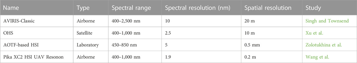
TABLE 1. Summary of hyperspectral imaging systems used in the Research Topic.
The first study Singh and Townsend investigates the correlation between measurements of foliar traits and stream water nutrient export, utilizing data derived from NASA’s AVIRIS-Classic hyperspectral data. To understand nutrient cycling and water quality in mixed-use ecosystems, the research employed structural equation models (SEMs) to analyze the relative influence of foliar chemical traits, watershed physiography, and human land use on water quality in Upper Midwestern United States watersheds. The SEMs demonstrated that foliar retention, as measured by AVIRIS-Classic, played a crucial role, negatively impacting watershed leakiness and positively influencing watershed retention. The results underscore the capacity of imaging spectroscopy to provide valuable insights into foliar traits affecting nutrient cycling, ultimately informing the development of resilient landscapes and restoration policies that consider the interplay of vegetation traits, physiography, and climate.
Xu et al. investigates soil oxides as crucial indicators for assessing soil quality, with implications for heavy metal adsorption, pollution remediation, and organic matter enrichment. The research explores the distribution of eight main soil oxides by analyzing 421 soil samples and utilizing two hyperspectral satellite datasets. This study finds that homogenization spectral transformation is optimal, and the difference model is suitable for oxide extraction by employing various data processing techniques. Using the OHS satellite sensor with a spatial resolution of 10 m, the research extracts soil component content on a large scale, offering valuable insights into environmental determinants and proposing technical solutions for digital soil research and treatment. The study was conducted at a site in Fenghuang County in the Xiangxi Tujia and Miao Autonomous Prefecture, Hunan Province, China.
Another study Zolotukhina et al. emphasizes the significance of remote mapping of chlorophyll concentration in leaves for diverse biological and agricultural applications. Various spectral indices derived from reflectance at specific wavelengths are used to quantify chlorophyll content, with the choice of index depending on the crop, environmental factors, and task at hand. Conventional multi-spectral imaging systems with limited spectral channels may not provide accurate results for mapping multiple indices, making hyperspectral imaging necessary. Acousto-optic imagers are highlighted for their precision, speed, and arbitrary spectral tuning capabilities. The research demonstrates the feasibility of extracting chlorophyll content distribution from acousto-optic hyperspectral data cubes, collected from five selected soybean cultivars’ leaves. Fourteen chlorophyll indices were evaluated, and the red edge chlorophyll index (CIRE) was identified as optimal, achieving a high coefficient of determination (0.993) and low root-mean-square error (0.66 μg/cm2). The study underscores the potential of acousto-optic hyperspectral imagery for mapping spectral indices and selecting optimal ones tailored to specific crops and environmental conditions.
The final work in this Research Topic Wang et al. focuses on combating the invasive weed Stellera chamaejasme in alpine grasslands on the Qinghai-Tibet Plateau. The researchers employed UAV Resonon hyperspectral imaging system to map the distribution of S. chamaejasme, utilizing dimension reduction, clustering, and ordination analysis. Field spectrometry analysis identified optimal wavelengths for discriminating S. chamaejasme, reducing hyperspectral imagery dimensions efficiently. Despite challenges in species-level identification using hyperspectral bands, reaggregating two-way indicator species analysis (TWINSPAN) ecological communities based on JM distance facilitated the delineation of S. chamaejasme communities. The study employed three classification algorithms (MLC, RF, SVM), with RF and JM-TWINSPAN yielding the best results (OA = 91.00%, Kappa = 0.83). The findings suggest that a multivariate approach integrating ecological analysis, separability measurement, and image classification can accurately map S. chamaejasme, offering a promising strategy for toxic weed control on the Qinghai-Tibet Plateau.
Author contributions
RR: Writing–original draft. AZ: Writing–review and editing. KS: Writing–review and editing. AT: Writing–review and editing. PG: Writing–review and editing. SH: Writing–review and editing.
Acknowledgments
The guest Editors would like to sincerely thank all the Authors who contributed to this Research Topic and the Reviewers who dedicated their time and provided the Authors with valuable and constructive recommendations. They would also like to thank the Editorial team of Frontiers in Environmental Science and Frontiers in Ecology and Evolution for their support.
Conflict of interest
Author AT was employed by The Aerospace Corporation.
The remaining authors declare that the research was conducted in the absence of any commercial or financial relationships that could be construed as a potential conflict of interest.
Publisher’s note
All claims expressed in this article are solely those of the authors and do not necessarily represent those of their affiliated organizations, or those of the publisher, the editors and the reviewers. Any product that may be evaluated in this article, or claim that may be made by its manufacturer, is not guaranteed or endorsed by the publisher.
Keywords: hyperspectral imaging, environmental monitoring, image processing, machine learning, remote sensing
Citation: Rajabi R, Zehtabian A, Singh KD, Tabatabaeenejad A, Ghamisi P and Homayouni S (2024) Editorial: Hyperspectral imaging in environmental monitoring and analysis. Front. Environ. Sci. 11:1353447. doi: 10.3389/fenvs.2023.1353447
Received: 10 December 2023; Accepted: 11 December 2023;
Published: 19 January 2024.
Edited and reviewed by:
Alexander Kokhanovsky, German Research Centre for Geosciences, GermanyCopyright © 2024 Rajabi, Zehtabian, Singh, Tabatabaeenejad, Ghamisi and Homayouni. This is an open-access article distributed under the terms of the Creative Commons Attribution License (CC BY). The use, distribution or reproduction in other forums is permitted, provided the original author(s) and the copyright owner(s) are credited and that the original publication in this journal is cited, in accordance with accepted academic practice. No use, distribution or reproduction is permitted which does not comply with these terms.
*Correspondence: Roozbeh Rajabi, cm9vemJlaC5yYWphYmlAdW5pZ2UuaXQ=