 Margaret Owuor1,2
 Thuareag M. T. Santos3
 Philip Otieno4
 Ana Carolina A. Mazzuco3
 Chima Iheaturu5
 Angelo F. Bernardino3*
- 1Wyss Academy for Nature at the University of Bern, Bern, Switzerland
- 2Institute of Ecology and Evolution, University of Bern, Bern, Switzerland
- 3Departamento de Oceanografia, Universidade Federal do Espírito Santo, Vitória, ES, Brazil
- 4Biosfera Research and Consulting Ltd., Nairobi, Kenya
- 5Institute of Geography, University of Bern, Bern, Switzerland
Mangrove forests are broadly recognized to support a variety of ecosystem services on coastal margins worldwide. These services may significantly contribute to the wellbeing of millions of people, but there is limited information about their importance in the Global South. This study mapped for the first time the flow of ecosystem services in Brazilian Amazon mangroves, which represent over 700,000 ha of mangroves in the country. We also identified the spatial changes in the flow of services across coastal landscapes, including urban, agricultural upland areas and coastal natural protected areas. Our matrix model indicated that mangroves, waterbodies, sandflats and mudflats are critical to the flow of multiple ecosystem services, including provisioning (fish, mariculture), cultural (historical and intrinsic value, research, and education), and regulation (climate, flood control, nursery, and breeding grounds). Social economic context, occupation, education, and residence time are important factors influencing villagers to identify the flow of ecosystem services, which could be compared across other coastal marine reserves in South America that have similar management of natural resources. Adjacent coastal upland habitats such as forests and croplands are important to support many provisioning ecosystem services to coastal villagers that would otherwise be obtained from mangroves, suggesting that protecting these connected habitats and supporting small-scale agriculture may help to avoid deforestation of mangrove forests. As over 80% of the mangroves in the country are managed as extractive reserves and may support communities with comparable socio-economic characteristics, we provide a foundation for the development and replication of ecosystem services assessments in Brazilian mangroves, which cover an area of over 1 million hectares. Our work highlights the importance of mangrove forests in providing food, and cultural services and to increase local climate resilience of coastal villages in the Amazon coast.
1 Introduction
Mangrove forests are important coastal ecosystems with potential value to climate change mitigation and adaptation strategies worldwide (Murdiyarso et al., 2015; Bernardino et al., 2024). Their efficient capacity as carbon sinks has led to an increased interest in evaluating regional and global variability in carbon stocks and burial in mangrove forests (Bernardino et al., 2020; Kauffman, et al., 2020; Breithaupt and Steinmuller, 2022; Passos et al., 2023). Mangroves may offer numerous ecological benefits through carbon accumulation and burial in tropical coasts, and many other ecosystem services (ES) that provide multiple direct and indirect resources to coastal communities (Barbier et al., 2011; Gutting et al., 2021). Over the past years, scientists have connected mangroves to provisioning ES, from fish capture to pharmaceuticals; to regulating ES, from natural hazard mitigation to pollination; to cultural ES, from aesthetic value to cultural heritage; and to supporting ES, from primary production to nursery grounds (Barbier et al., 2011; Himes-Cornell et al., 2018; Afonso et al., 2021). As a result, conserving mangrove forests is regarded as an important climate adaptation strategy to curb carbon emissions, as well as a public good by coastal communities regardless of their legal protection as reserves or the value assigned to them in economic markets.
As an opposing pressure, the continuous population growth and rapid coastal development have made mangroves one of the planet’s most endangered ecosystems (Goldberg et al., 2020). Estimated global loss of mangrove cover varies between 0.16% and 0.39% annually (Goldberg et al., 2020), and the conversion of mangroves into agriculture, aquaculture, and urban areas is a main driver of mangrove deforestation (Kauffman, et al., 2016; Kauffman, et al., 2018a). In parallel to the losses of ecological processes in degraded mangroves, which may include carbon capture and forest productivity (Gomes et al., 2021a; 2021b), the loss of mangroves may limit their potential to deliver ecosystem services in the future. Simultaneous with conservation and restoration efforts, mangrove sustainability in the long term fundamentally depends on the valuation of its ecosystem services (both monetary and non-monetary), as well as the identification of the connections (or the flow) between the ecosystem, biodiversity, and the benefits communities derive. Detailing this information is essential to improve management instruments such as spatial planning, impact assessment, and environmental fines which currently are developed based on very scarce data (CDB, 2012; Canonico et al., 2019).
Since the development of the concepts around ecosystem services (ES), a wide range of evaluation frameworks and mapping approaches have been developed to fit a variety of contexts. ES mapping is particularly useful to link biophysical processes underlying ecosystem structure with human-induced modifications, such as land-use change (Müller and Burkhard, 2012). The identification of flow between ecosystem components and uses enables the evaluation of services’ sustainability according to different scenarios and the connection between areas or habitats (Bagstad et al., 2013; Burkhard et al., 2014), also providing information on the current and future biophysical capacity of an area to produce ES. In this study, flow is used in context as defined by Burkhard et al. (2014) to mean de facto used set (bundles) of ecosystem services and other outputs from natural systems in a particular area within a given period. To that end, the use of flow maps helps to recognize the spatial distribution of ES that could support different types of decision-making for the conservation of many ecosystems (Bagstad et al., 2013).
Recent approaches to ES mapping also incorporate stakeholders into the modeling process (Campagne and Roche, 2018), thus improving legitimacy, enhancing knowledge sharing, and highlighting the ES that are most important to a particular context. Studies show that the understanding of localization and different knowledge systems, as reflected by the different users on the uses of mangroves, contributes to management effectiveness by improving the role local users play in decision-making as beneficiaries of mangrove ecosystem services (Ruslan et al., 2022). This methodological rationale is appropriate for regions where various stakeholders depend on a particular ecosystem but have competing interests that affect the ecosystem’s health, which is the case of the Amazon mangrove forests in Brazil. Hence, based on multiple evidences for the provision of ecosystem services from wetlands to local villagers (Barbier et al., 2011; Himes-Cornell et al., 2018), we hypothesize in this study that indigenous and local community groups depend on and access the resources or benefit from the regional coastal landscapes. Identifying the flow of ecosystem services with stakeholder’s involvement helps them to identify areas of resource use and foster the conservation of ecosystems they rely on. Considering the fast pace of the current changing world, multiple stressors (e.g., climate change, infrastructure development, biodiversity loss, and changing consumption patterns), the ability to follow changes in ES in space and time allows researchers to accurately estimate drivers’ impact on ES delivery (Campagne and Roche, 2018). Besides, when built together with local residents, such evaluations of ES trade-offs can significantly enhance policy, community-based conservation, and ecosystem-based approaches to the management of such resources (Campagne and Roche, 2018).
Brazilian mangroves are among the largest in the world, of which over 70% are located along northern Brazil’s Amazon coastline (Bernardino et al., 2021). These mangroves are typically managed through reserves of sustainable use to meet conservation and development needs (UNEP, 2014). These reserves are the most common mangrove management system in South America, where it is estimated that nearly 40 million people living in the region might be dependent on the ES provided by these unique forests (UNEP, 2014). However, although multiple mangrove benefits to those coastal communities are often recognized, those relationships are not yet mapped in detail. In this study, we adopted a rank-matrix approach based on local stakeholders’ knowledge to identify and map the flow of ecosystem services in Brazilian Amazon mangroves and associated coastal habitats. The dataset was built through community surveys carried out at in several villages in the Curuçá region on the Amazon coast, located in Pará state, north of Brazil (Figure 1). This evaluation considered a wide range of ES types, scored, and connected to different habitats by the local communities’ knowledge and vision of the ecosystem fluxes. We focused on fisher’s as we identified this group were the main stakeholders living in the region, and the ones that most heavily rely on the ecosystem services from natural mangrove forests. Given the proximity and the high conservation status of mangrove forests on the Amazon coast, we hypothesized that mangroves would be key to the flow of several ecosystem services to local communities. We also hypothesized that perception of the flow of mangrove ecosystem services are influenced by a host of socio-demographic characteristics including education, type of livelihood, source of income and knowledge of the ecosystem services among others (Aburto-Oropeza et al., 2008; Hernandez-Blanco et al., 2021). Our findings provide a key assessment to improve our understanding of the importance of mangroves to coastal villagers in Northern Brazil.
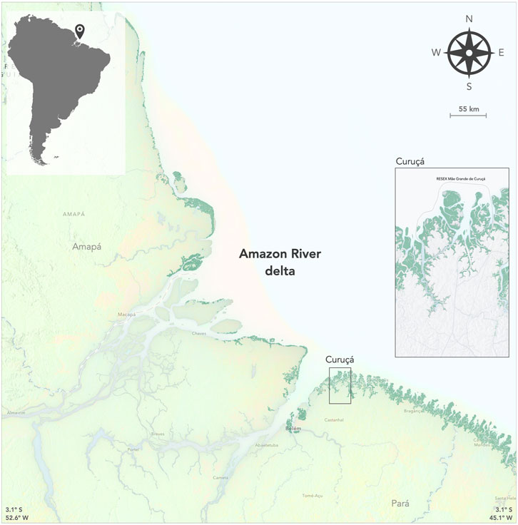
FIGURE 1. Map of the Brazilian Amazon coast indicating the extent of mangrove forests (dark green) and the studied regions in Curuçá. Right panel. Detail of Curuçá mangroves and the border of the extractive reserve (RESEX). Map produced with ArcGIS Online 2023, National Geographic Society Subscription ID 3968399452.
2 Methods
2.1 Study area
Brazil has the second largest global expanse of mangrove forests (11,400 km2), with over ⅔ of those mangroves located in the northern region along the Amazon coast (Bernardino et al., 2022; Bunting et al., 2022). Amazon mangroves include well-developed forests and hold ecosystem carbon stocks that are 2 to 10-fold higher than nearby upland forests in the Amazon and Caatinga biomes (Kauffman et al., 2018b). Mangrove forests in Brazil have been historically protected by law with over 80% of forests within protected areas which markedly limited their loss to coastal development and aquaculture (Bernardino et al., 2021).
This study was carried out in Curuçá and nearby villages (00°43′48″ S–47°51′06″ W) located on the Northern Amazon coast of Brazil (Figure 1). It is a humid equatorial region (Amazon Rainforest equatorial climate-type Am), characterized by high temperatures (27°C annual average), low thermal amplitude, and high precipitation of over 2000 mm per year (Bernardino et al., 2015). Curuçá has over 40,000 residents and its economy is based on fishing, agriculture, and tourism in mangroves. The city is within a coastal extractive reserve (Mãe Grande de Curuçá Reserve), which holds one of the largest protected areas on the Amazon coast with rich mangrove ecosystems so there is good representation for other reserves in the country. The reserve has nearly 60 traditional community settlements with approximately 3,000 families living on estuarine islands, tidal creeks, rivers, beaches, and mangroves (Figueiredo et al., 2009).
2.2 Ecosystem services assessment (matrix model)
To quantify the flow of ecosystem services (ES) within the study area we adapted the matrix model (Campagne et al., 2020), which was applied and developed in a host of case studies (Jacobs et al., 2014; Basheer et al., 2022). The matrix model is based on surveying stakeholders including local experts from Government research organizations, local communities, and laymen who are typically engaged in determining ES scoring. The model involves filling a matrix (ranking) of ecosystem services against an (or a group of) ecosystems. The matrix approach (also referenced as look-up tables) is based on the use of a visual panel of geospatial units classified according to ecosystem type, land cover, habitats, or other geographical classification related to services or goods, which allow participants to attribute scores (0–5, from not relevant to very high; Table 1) to ES flow, capacity, supply, use, demand, or other concepts (MEA, 2005). The ES matrix approach was used to map and quantitatively describe the flow of the various mangrove services in the study region within the extractive reserve. Rather than using an existing matrix from an already published study, we used an empty ES matrix that was filled by the participants based on land use land over types (seven in total).
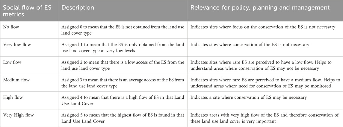
TABLE 1. Policy relevance of the Ecosystem Service Flow Metrics. Values indicate low flow (0) to very high flow (5).
2.3 Data needs and sources
Application of the matrix model using participatory mapping (through workshops) requires a range of datasets obtainable from various sources, including land use and land cover maps. The land use land cover (LULC) map used in this study was derived from the Sentinel-2 (S-2) satellite imagery for the year 2022 (https://sentinel.esa.int/web/sentinel/missions/sentinel-2; accessed on 27th September 2022). The LULC maps for Curuçá were developed following best practices for land cover classification using remote sensing data (Mountrakis et al., 2011). Specifically, we utilized a support vector machine (SVM) classifier, which has demonstrated high accuracy for complex land cover categorization from satellite imagery (Pal and Mather, 2005). SVMs are supervised, non-parametric statistical learning models that construct optimal decision boundaries between classes based on labeled training samples (Foody and Mathur, 2004).
We implemented the SVM classifier using S-2 multispectral imagery in ESRI ArcGIS Pro software. Class divisions were mapped for six categories: Forest formation (Amazon Rainforest, other modified forest types); mangroves; other vegetation types (cropland, pastureland); coastal areas (mud and sand flats); water body areas (ocean, river, lakes, channels, and creeks); and urban areas. Rigorous accuracy assessment was performed using standard methods (Souza et al., 2020) including high-resolution visual inspection with Google Earth, collection of in situ field reference data and MAPBIOMAS Project system of Land Cover Class Definitions. These maps and habitat classifications tend to be easily recognized by local stakeholders and are typical representations of ecosystem types on the Brazilian Amazon coast. We assessed accuracy both quantitatively using confusion matrices and derived statistics, as well as qualitatively using expert analysis ensuring class divisions matched typical ecosystem representations.
2.4 Data collection
Data on the perception of the flows for the mangrove ecosystem was collected from the various resource user groups in Curuçá and they included: main sources of livelihoods, places of residence, access and use of mangrove ecosystem services, and knowledge on the role of mangroves and other landscapes in the provision of ES. Data collection was based on participatory mapping of the flow ES across the various LULC types in Curuçá, Brazil. This was conducted by presenting a map of the land use land cover classifications to the stakeholders for them to identify where they got the ES from. Visual panels for ES prioritization surveys were developed based on the LULC maps of the study area. We integrated the land cover type into the matrix study to allow the estimation of the flow of ES across land use change (Figure 2). The survey was designed considering the active participatory engagement of local villagers in the ecosystem service (ES) assessment, with a four-step process of data acquisition.
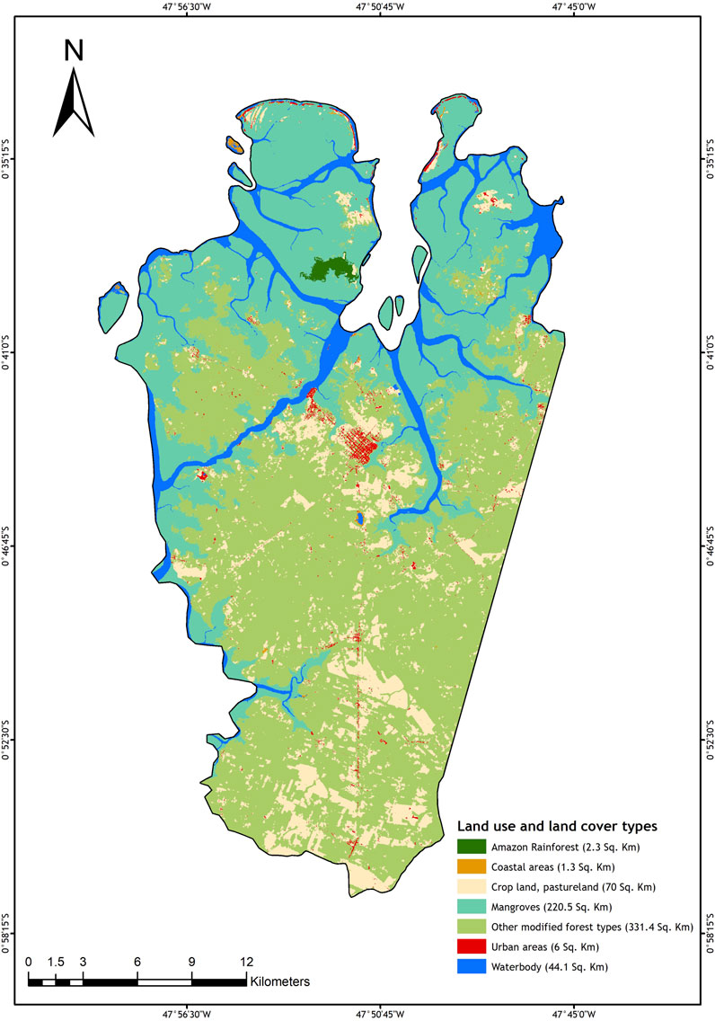
FIGURE 2. Land cover land use (LCLU) of the Mãe Grande de Curuçá RESEX, indicating the seven major land cover categories. Map created with ESRI ArcGIS Pro software (https://www.esri.com/en-us/arcgis/products/arcgis-pro/overview).
First, a scoping exercise was performed through a focus group discussion (involving 20 participants) to identify the ES and the LULC classes present in the study region. One workshop was held with community-based organizations, covering the entire Curuçá. The workshop was held in Boa Vista do Muriá village with 20 participants from Curuçá and the surrounding villages (Abade, Boa vista do Iririteua, Cabeceiras, Coqueiro, Itajuba, Livramento, Muriá, Mutucal, Pedras Grandes, Pindorama, Ponta de Ramos and Recreio). The participants were representatives of governments (4), villagers (6) and local leaders (10). Selection of the participants was done bearing in mind the multiplicity of users in Curuçá mangrove and was sufficiently diverse to represent most of the key stakeholders involved in carrying out research and in the conservation. Several issues were discussed during the meetings ranging from the topic of ES, defining ES, the potential of Curuçá mangrove to provide these services, to the state of management of the reserve and the different organizations involved. Participants were taken through an introductory session in which they refreshed their familiarity with the ecosystem types in Curuçá, defined what ES is and discussed the ES classification using the Millennium Ecosystem Assessment framework. This discussion included elicitation of the different LULC and ES and a total of 24 ES were selected and assigned using the categories described in the Millennium Ecosystem Assessment (MEA, 2005).
The second step was the development of land use land cover maps that was used at the actual data collection to aid participants to visualize the spatial extent of the area during scoring of ES flows according to land use land cover type. The process of generation of the land use land cover map is described above. Also, during this step, a data collection tool was developed based on the information collected during the scoping stage. The main components of the data collection included; consent form, socio-demographic characteristics such as duration of stay in the area, gender, sources of income, membership to social groups, products obtained from the mangroves, knowledge of the ecosystem services associated with mangroves, matrix table for scoring the flow of an ES against a land use land cover type (scores ranged from 0 to 5 as discussed in the matrix model section), threats to the land covers, among others. The data collection tool and the land use map were pretested together with a section of the community (n = 20).
The third step involved modification of the data collection tool based on the feedback from the pretest. One such concern was that the tool was long, hence some questions were dropped, the final data collection tool was also transformed into a digital survey. The survey tool was designed in English and translated to Portuguese, and uploaded to the ArcGIS Survey123 tool, where it was hosted online (https://survey123.arcgis.com/) and later applied the questionnaires in the local community (fourth step).
The fourth step was the actual data collection, the survey tool was presented to the local community through workshops where discussions around the research and the objectives were discussed with the participants. A total of 6 workshops were held, with each workshop having around 20 participants. The workshops were held in 6 different villages, with each targeting members from 2 villages for a total of 12 villages represented. A total 109 valid responses were obtained. Identification of the participants was not purely random since participants needed to be people knowledgeable with the various land use land cover types and ecosystem services. We assumed that by selecting participants based on their resource use would create a mix of diversity capable of providing insights into the flow of the ecosystem services.
2.5 Data analysis
Data on the socio-demographic and economic characteristics of the respondents were analysed for measures of central tendencies and dispersion such as mean, and percentages using STATA 14 (Table 2). Inputs from the workshops and group discussions were organized in summary matrixes containing the averaged ES scores (0–5) attributed by the villagers to the flow or relationship between coastal Amazon habitats and ES types. Habitat prioritization was evaluated using printed maps of the reserve land cover and developed based on the result of the summary matrixes. ES flow patterns were represented using maps and plots to allow spatial visualization of change in scoring. Inferential analysis was performed to acess the variability in the score patterns between different landscapes. We used a 1-way (factor = ecosystem) permutational multivariate analysis of variance using distance matrices (PERMANOVA; Anderson, 2017). PERMANOVAs and plot matrixes were built using the results of the individual responses, each participant was included as one sample in the analyses (absence of scores were not included in the analysis), and pairwise post hoc comparisons were added to the significant results (to test the dissimilarity between scores of each landscape type). Comparisons and statistical analyses were carried out separately for each of the three main ES categories (provisioning, cultural, and regulation) highlighted by the studies. Data were transformed (square-root x+1) before PERMANOVAs to reduce variance within analyzed factors (Anderson, 2017). We assumed α = 0.05 and determined the significant p values. Graphical and analytical processing was performed in the R project (R Core Team, 2021), using the packages “vegan” for PERMANOVA, “ggalluvial” for flow plots (Oksanen et al., 2018; Brunson and Quentin, 2020).
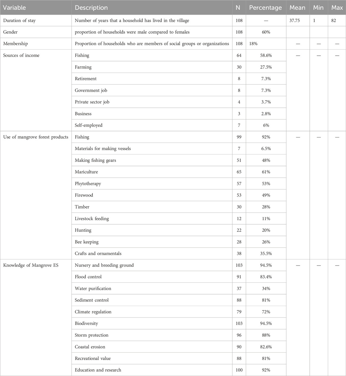
TABLE 2. Socio-demographic characteristics of community members who contributed to this study from the Curuçá region.
We also conducted a multivariate multiple regression analysis to assess factors that influence perception of the flow of ecosystem services for each of the seven landscape types evaluated. However, we only present the regression results for the mangrove ecosystem given the main study objectives. We used a multivariate analysis to analyze the relationship between the 24 mangrove ecosystem services against a similar set of potential predictors (based on the literature; Campagne et al., 2020), which included length of stay, membership to social groups, dependence on mangroves, type of livelihood, and knowledge of mangrove ecosystem services. The first step in the analysis involved running a MANOVA test in STATA 14 to show whether all the equations taken together were statistically significant. Several stepwise fitting of MANOVA was conducted and only eight of the ecosystem services were significant when taken together. The eight ecosystem services were then subjected to multivariate regression analysis to obtain coefficients, standard errors, and p-values for each of the predictors in each part of the model, as shown in Eq. 1:
where:
3 Results
3.1 Socio-economic profile of the participants
The majority of the respondents who participated in the study were males (60%) with a strong reliance on fishing (Table 2). The average number of years that a resident had stayed in the village at the time of data collection was 37.8 years. Other socio-economic characteristics considered in the study included duration of stay in the area, membership to social groups, sources of income, use of mangrove forest products, and knowledge of mangrove ecosystem services (Table 2). Only about 18% of the respondents stated that they belong to social groups in the community. Fishing was the main source of income to about 67% of the respondents, followed by farming at 28%. The majority of the respondents (92%) stated that fishing was their main occupation, with mariculture within the mangroves also important to about 61% of the respondents.
3.2 Flow of ecosystem services across land cover types in Curuçá
Provisioning ecosystem services identified by the villagers’ included activities associated with fisheries (fishing catch, fishing vessels, mariculture and gear), energy sources (firewood, coal, timber), other food supply or maintenance (livestock feeds, hunting, and beekeeping), herbal medicine (phytotherapy), and handcraft (ornamentals). Out of the twelve (12) provisioning ES prioritized, very high flow (score 5) was only found for fish catches, which were reportedly associated with mangrove forests, and waterbodies (Table 3; Figure 3). Mangrove mariculture, phytotherapy, and firewood extraction from forests (Amazon and other types) and crop and pasture lands were scored with the medium flow (score 3; Table 3). Timber for housing was equally reported with medium flow from the Amazon rainforest and other types of forests within the reserve. The analysis of the individual score patterns revealed that provisioning ES flow is mostly associated with mangroves, the Amazon rainforest and other forests, and less associated with urban areas (PERMANOVA F = 50.2, p = 0.01, Table 4). The Amazon rainforest has consistently medium scores (mostly scoring twos and threes) across all the provisioning ES when compared to the other landscapes. All the other landscapes showed variable ES score patterns, with predominant small scores (0 and 1) to several of the provisioning ES.
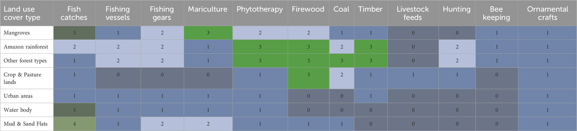
TABLE 3. Average score values of provisioning ecosystem services in the Curuçá region, indicating flow intensity between land cover type from 0 (no flow), to 5 (very high flow).
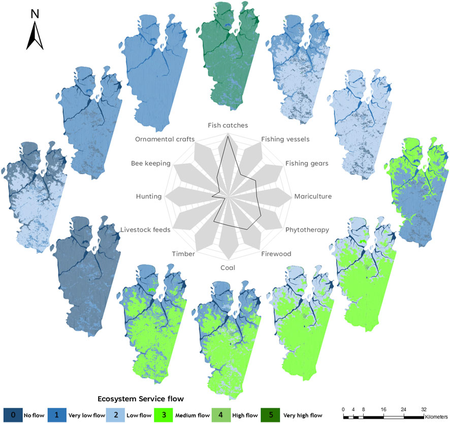
FIGURE 3. Average score values of ecosystem service flow across provisioning ecosystem services and land cover types in the marine reserve Mae Grande de Curuçá, Brazilian Amazon. Areas in blue indicate no flow to very low flow of ecosystem services whereas green areas indicate higher flow.
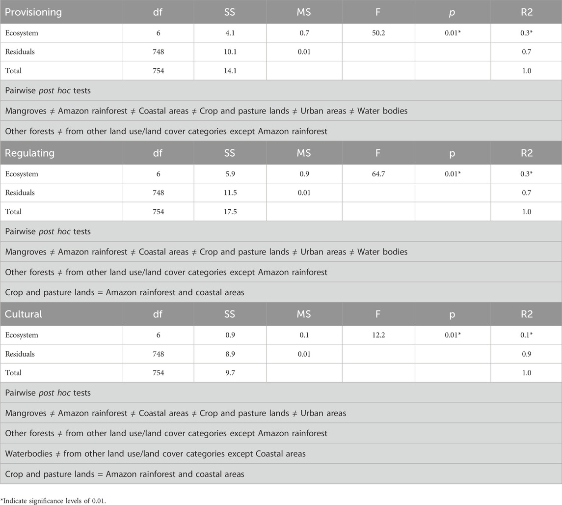
TABLE 4. PERMANOVA results of ecosystem service flow scores among landscapes studied in the Curuçá region, Brazil.
The local community identified eight regulating ES flow from the coastal habitats in the Curuçá region, which included biodiversity conservation, animal nursery and breeding, water purification, and other services associated with coastal resilience (climate regulation, coastal erosion, flood control, sediment control, and storm protection). The majority of the local community members are of the view that there is a very high flow (score 5) of nursery and breeding for fish and other animals such as crabs, birds and monkeys within the mangroves (Figure 4; Table 5). A high flow (score 4) was also attributed to nursery and breeding grounds for fish and other animals associated with the Amazon rainforest, waterbodies, coastal areas (mud and sand flats), and other forest types. Flood control and water purification had a high flow (score 4) from mangroves, while the Amazon rainforest, other forest types, and coastal areas are regarded to offer medium flow (score 3). Similarly, biodiversity conservation has a high flow to the mangrove ecosystem, while the amazon rainforest, other forest types, coastal areas and water bodies are regarded to offer medium flow. Urban areas have a low flow (score 2) for all regulating ES presented (Figure 4; Table 5). Similar to the provisioning services, most regulating ES flow was attributed to the mangroves (PERMANOVA F = 64.7, p = 0.01, Table 4), which together with the mud and sand flats and the Amazon rainforest showed a similar association with all of these services (Figure 4). Crop and pasture lands and urban areas scored the least regulating ES flow (scores 1–2). Crop and pasture lands also scored consistently low for the provisioning ES that were considered in the study. Nevertheless, they scored high for cultural services; historical value for generations, and intrinsic values in particular.
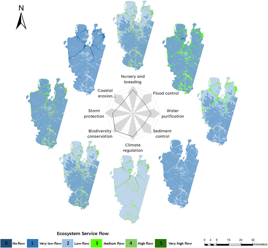
FIGURE 4. Average score values of ecosystem service flow across regulating ecosystem services and land cover types in the marine reserve Mae Grande de Curuçá, Brazilian Amazon. Areas in blue indicate no flow to very low flow of ecosystem services whereas green areas indicate higher flow.
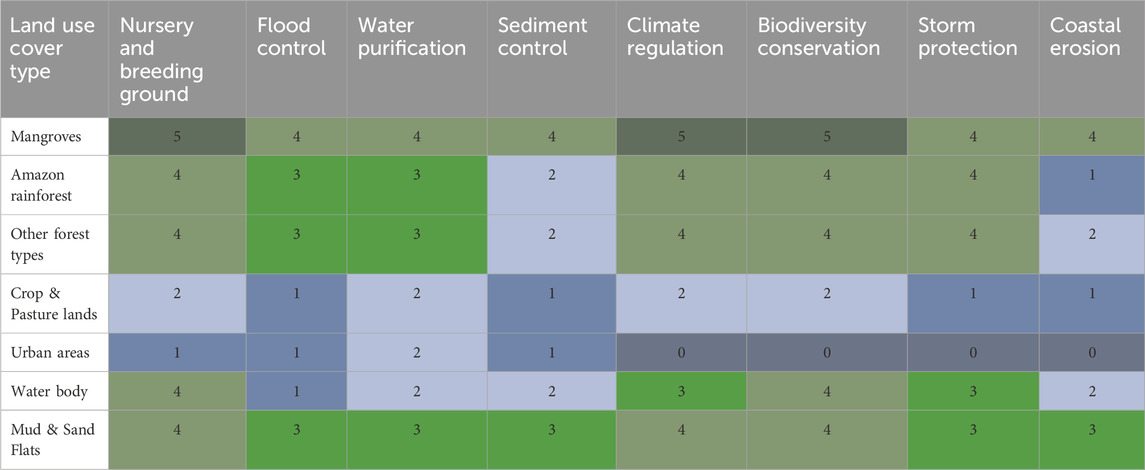
TABLE 5. Average score values of regulating ecosystem services in the Curuçá region, indicating flow intensity between land cover types from 0 (no flow), to 5 (very high flow).
The majority (over 90%) of the local community members were of the view that there is a high flow (score 4) of education and research within the mangroves, Amazon rainforest, other forest types, coastal areas, and water bodies (Figure 5; Table 6). Stakeholders scored a medium flow (score 3) in education and research for urban areas. Tourism and recreation have a high flow in the mangrove ecosystem, mud and sand flats and urban areas, while the Amazon rainforest, other forest types and water bodies were regarded to have medium flow (score 3). In general, mangroves had a very high flow of historical value for generations, while the other land use and land cover (LULC) types are regarded to offer a high flow. Similarly, mangroves and coastal areas (mud and sand flats) have a very high flow for intrinsic value, while the other LULC classes have a high flow of ES (PERMANOVA F = 12.2, p = 0.01).
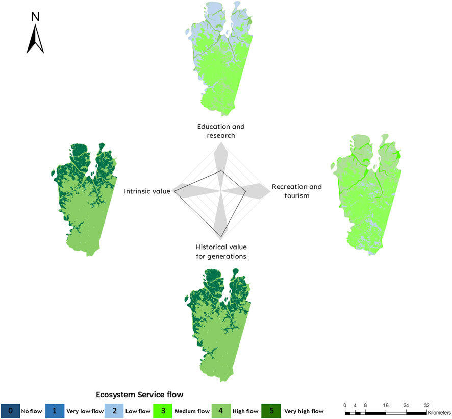
FIGURE 5. Average score values of ecosystem service flow across cultural ecosystem services and land cover types in the marine reserve Mae Grande de Curuçá, Brazilian Amazon. Areas in blue indicate no flow to very low flow of ecosystem services whereas green areas indicate higher flow.
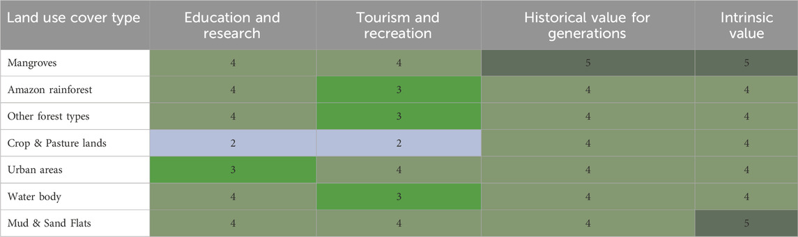
TABLE 6. Average score values of cultural ecosystem services in the Curuçá region, indicating flow intensity between land cover types from 0 (no flow), to 5 (very high flow).
3.3 Factors that influence the perception of the flow of mangrove ecosystem services
There was a strong agreement among villagers that there is a high flow of ecosystem services to mangroves, including fisheries (95%), intergenerational values (91%), intrinsic value (93%), nursery and breeding ground (94%), climate regulation (89%), biodiversity conservation (96%), and storm protection (87%; Table 7). On the other hand, there was also a near-universal understanding among villagers that there is a low flow towards the crafting of fishing vessels (86%), coal (86%), wood for construction (83%), livestock feeds (97%), hunting (95%), and beekeeping (86%) from local mangrove forests. The perception on the understanding of the flow was mainly influenced by the period each respondent lived in the region, by their association with social or environmental organizations, and if they lived from fishing or from other activities.
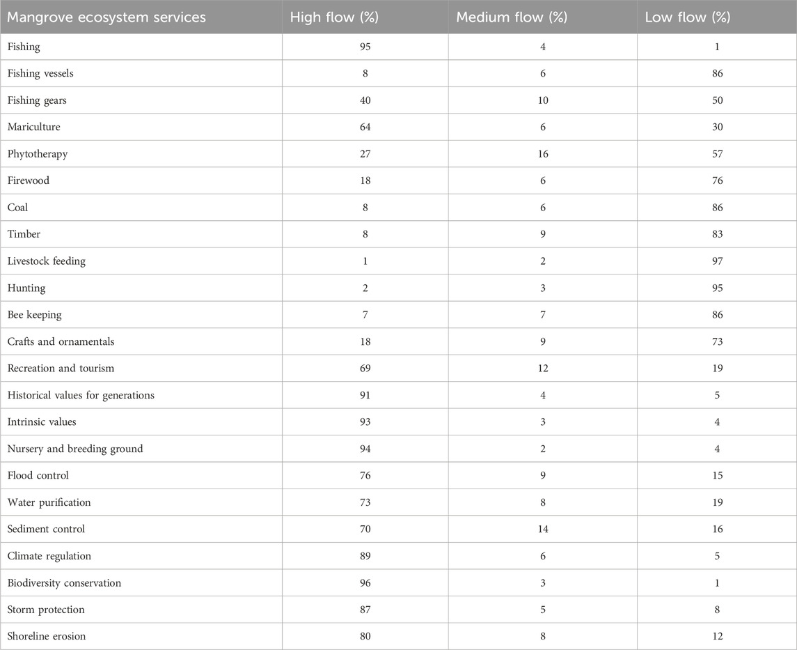
TABLE 7. Percentage scores for the flow of mangrove ecosystem services.
Our multiple regression analysis suggests that a higher flow of mariculture was associated with respondents who depended on mangroves for mariculture; while its low flow was scored by those who had lived in the village for long (Table 8). Perception of low flow of firewood was associated with respondents who reported to depend on mariculture, and those who stated that mangroves provided water purification services; while high flow of firewood was associated with respondents who stated that they depended on mangroves for firewood, phytotherapy, fishing, and making fishing vessels. Higher flow of tourism and recreation in the mangroves was associated with respondents who associated mangroves with provision of recreational and water purification ecosystem services; while low flow of tourism and recreation was associated with respondents who were aware that mangroves provided water purification services. Higher flow of flood control ecosystem services was associated with respondents who stated that they aware of mangroves as important in flood control, sediment control, and those who dependent on mangroves as a source of crafts and ornamental materials.
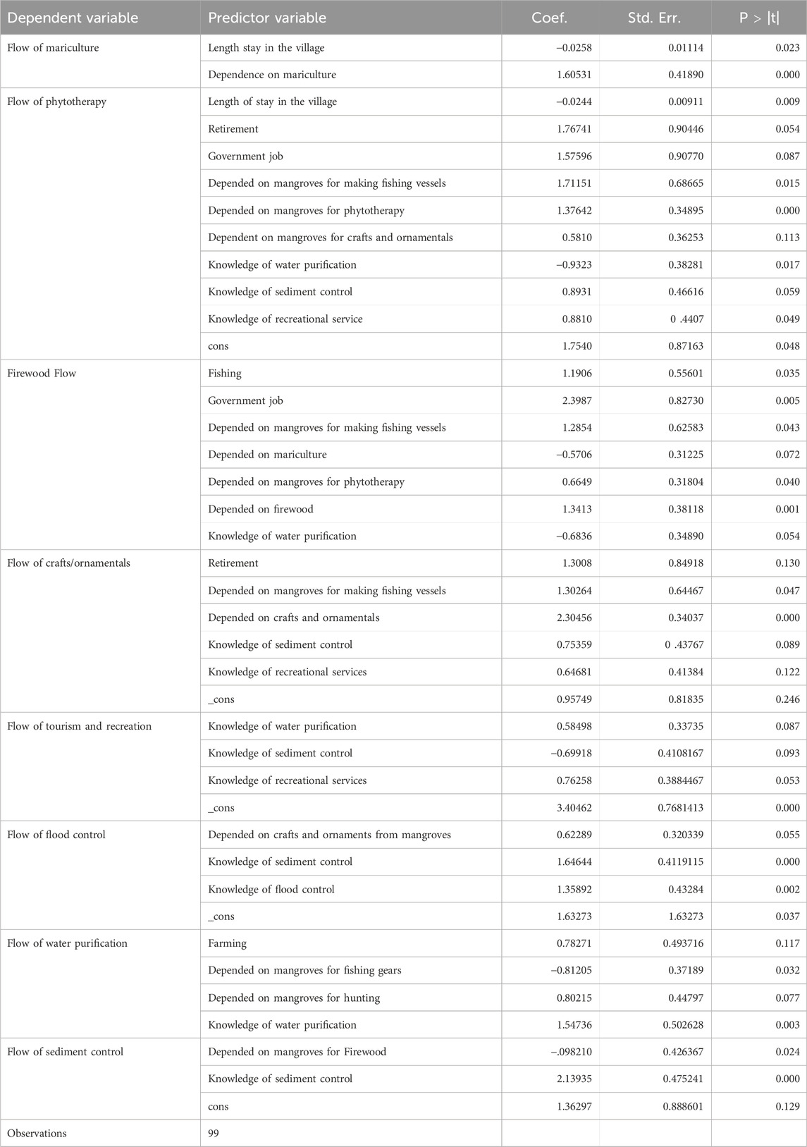
TABLE 8. Multivariate multiple regression analysis for predictors of the perception of flow of mangrove ecosystem services.
4 Discussion
Here we provide the first empirical assessment of ecosystem service flow in the Brazilian Amazon coast based on local community perceptions. Although there is a growing number of studies investigating ecosystem services and their implication for management in wetlands (Barbier et al., 2011), most of the studies have focused on the United States and Europe with regions such as Africa and South America recording fewer studies. We found that land use land cover was a key determinant of the ecosystem services flow in the Amazon coast of Brazil, suggesting that the size, habitat composition, and conservation of habitats may determine its ability to provide ecosystem services to coastal communities. Respondents perceived that the Amazon coast mangroves had the greatest ability to provide flow of a number of ecosystem services when compared to urban or upland forested and agricultural landscapes, supporting our hypothesis that mangroves would offer key ES to coastal villagers (Figure 6). In addition, coastal habitats and waterbodies that are in proximity to mangroves were also highly relevant to the flow of ecosystem services, which suggests the importance of habitat connectivity and of marine reserves in preserving coastal ecosystems along the land-ocean continuum (Aburto-Oropeza, et al., 2008).
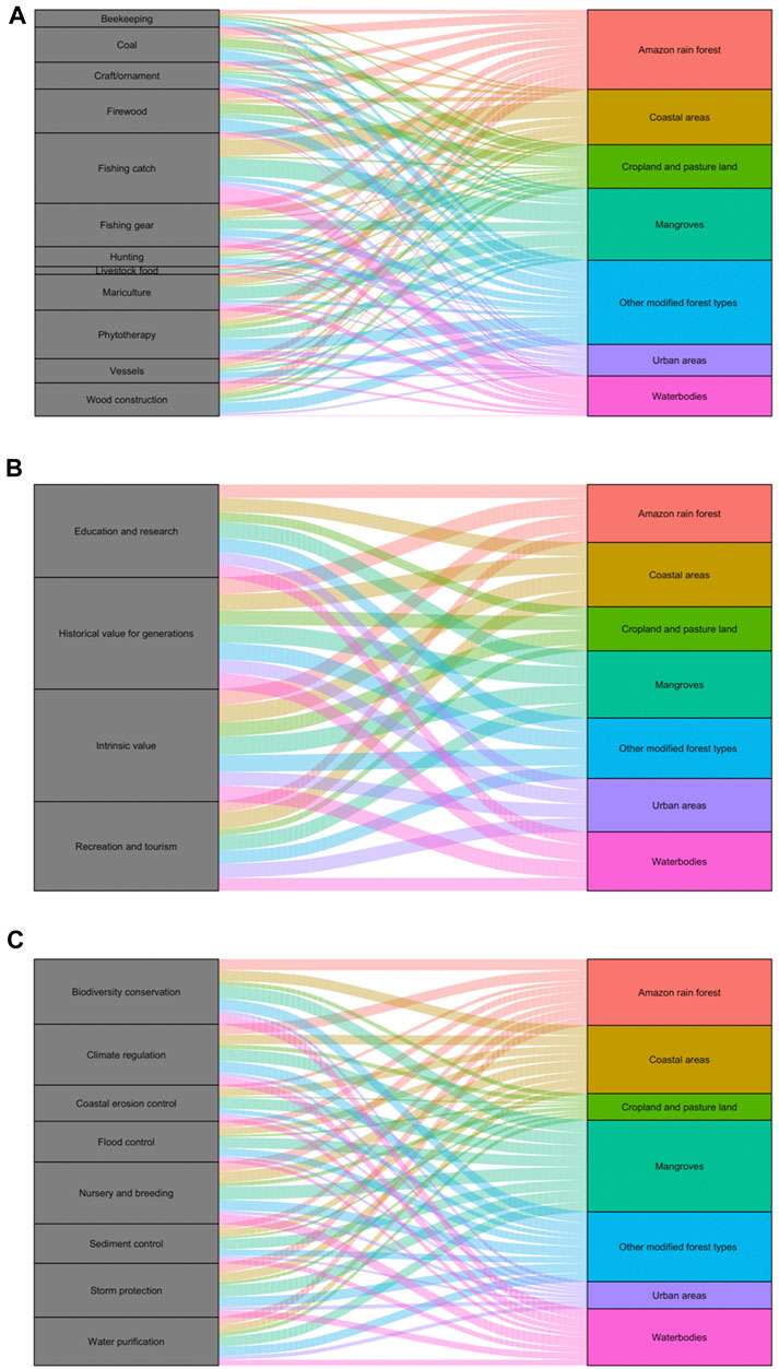
FIGURE 6. Schematic flow of provisioning (A), cultural (B) and regulating (C) ecosystem services across landscapes in the study region.
Mangroves were identified by community members to be key in providing provisioning ecosystem services that include a number of food items and crafting materials that are essential to the lives of coastal villagers. Fish and crustaceans are key protein sources of coastal communities globally and the flow of these ecosystem services from mangroves and connected coastal habitats is widely recognized and valued (Aburto-Oropeza, et al., 2008; Hernandez-Blanco et al., 2021). Mangroves and connected coastal habitats are important nursery habitats for several estuarine and marine species (Acosta and Butler, 1997; Hutchison et al., 2014), mainly because these ecosystems promote the migration of species and enhance the availability of nutrients (Valiela et al., 2013; Lana and Bernardino, 2018). As a result, the remarkable stakeholder’s recognition of the joint importance of mangroves, waterbodies, and coastal areas (mud and sand flats) to the provision of food and materials provides further support for their conservation. The need for conservation of upland areas near mangroves brings important policy challenges with current challenges to control deforestation in the Brazilian Amazon (Carvalho et al., 2019). To achieve better outcomes, a strategy to link current mangrove protection to nearby coastal landscapes (rivers, croplands and other forest types) would likely improve the national determined targets to lower carbon emissions and improve the benefits to coastal communities as these landscapes would provide wood that would otherwise be extracted from mangroves (Bernardino et al., 2024).
Provisioning services with medium to low flow were associated with mariculture and other extractive activities, which are often prohibited or controlled in mangroves of the Brazilian Amazon. Some of these materials are easily obtained on converted land near villages, as indicated by the high flow of these services on those landscapes. This is in contrast to many other coastal communities in Africa and Asia which widely use mangrove wood for fuel and construction (Owuor et al., 2019). Although the diversity and flow intensity of provisioning services such as firewood in the Brazilian Amazon may be limited due to the availability of urban utilities, mangroves may be an important source of these materials in isolated or lower-income communities in Africa and Asia (Abdullah-Al-Manun et al., 2017; Owuor et al., 2019). The limited use of firewood from Amazon mangroves is also explained by the limited road access to these areas as a result of their protection. Fragmentation and degradation of mangroves will expectedly increase the use of firewood and decrease the value of other services provided (Brander et al., 2012). As expected, mangroves, coastal areas, and forests were also key to the flow of regulating ES on the Amazon coast. High-valued regulatory services such as storm protection, climate mitigation, and biodiversity conservation were identified in Amazon mangroves, which resemble the high flow of those services from wetlands globally (Barbier et al., 2011).
We also observed that cultural ES were important in several land use land cover types within the Amazon region, including mangroves. Many coastal villagers frequently use these areas for cultural ES and have a strong connection to their preservation. This is also true for a diverse range of landscapes including nearby croplands, forested areas and aquatic habitats. The value of nearby continental landscapes to the flow of ecosystem services to coastal communities is often unrecognized and unchecked, but our results indicate that croplands, and continental forests add important flow of cultural and provisioning services to villagers. Our results support that the forested and agricultural areas near to those villages are extremely important to them, both as a source of food (manioc and banana plantations), and also culturally, as they spend time in the “farinha houses” processing manioc creating a strong connection to these landscapes. Our results also support that these communities need to be actively involved in the management of those areas, with proper legal framework so they can help enforce legal rights and the protection of these habitats. Although many of the Brazilian coastal extractive reserves allow the participation of stakeholders in management and use decisions, law enforcement, and protection are often bypassed by commercial and external users.
Based on the multivariate regression, the factors that influenced respondents’ perception of the flow of the mangrove ES were the length of habitation in the area, membership to a social group, dependence on mangroves, type of livelihood and knowledge of mangrove ecosystem services. The perception of the flow of ecosystem services is typically influenced by a host of factors, which may include the direct reliance on an ecosystem, socio economic and demographic characteristics of respondents and awareness and direct use of ecosystem services (Hicks and Cinner, 2014; Chen et al., 2015). The strong user’s perception of ecosystem services benefits from mangroves has direct implications for their future valuation as the value of ecosystem services increase in connected wetland habitats, so the stakeholder’s recognition would support an area-based valuation of those services (Brander et al., 2012). The marine reserve in Curuçá has nearly 22,000 ha of mangroves and 4,500 ha of coastal areas and waterbodies; which were highly associated with ES flow. Our survey covered an estimated population of 16,409 residents and 3,963 households (IBGE, 2010), but the number of residents and non-residents benefiting from mangrove services could be much higher as the Amazon coastal region is mainly connected by rivers and coastal bays. These highly connected landscapes, low fragmentation and the large extension of mangroves on this Amazon coast suggest that the associated value of those mangroves should be extremely high (Brander et al., 2012).
The strong association between social context and livelihood to the perceived flow of ecosystem services in the Brazilian Amazon may reasonably match the perceived flow of those mangrove services in communities from other regions of the country that live within managed extractive reserves. These reserves cover 87% of the country’s mangrove area, and over 2/3 of them allow extractive use of mangroves and nearby coastal ecosystems (Bernardino et al., 2021). The consistent management of these reserves should facilitate the mapping of ecosystem services in the country and their valuation on a nationwide scale. Information and education may be also critical to the perceived flow of ecosystem services from mangroves and other landscapes (Lamarque et al., 2014; Henderson et al., 2016; Chen et al., 2018), but the effect of education, extension projects, access to seminars, or to internet has not been assessed in this study. Such strategies could help local communities develop more critical thinking and careful observation of natural processes. As a result, the perceived flow of ecosystem services including invisible ones such as regulating and supportive ecosystem services may be more heterogeneous spatially and across areas of variable income per capita.
While this study provides novel insights into community perceptions of ecosystem service flows in the Amazon region, some limitations should be noted. The data represents a single snapshot in time and location. Expanding participatory assessments across multiple time periods and mangrove sites would strengthen generalizability. The survey data is also subject to individual biases and recall limitations. Supplementing surveys with ecological data could further validate perceived service flows. Additionally, assessment of the determinants of perception of the flow of ecosystem services only focused on mangrove services overlooking terrestrial system contributions. Future studies should adopt a coupled social-ecological approach spanning coastal and inland habitats. Applying an intersectional lens to evaluate how gender, age, culture, and other factors shape ecosystem service perceptions would also enrich understanding. Long-term monitoring is needed to track how development trajectories alter ecosystem service flows and community dependencies. Fostering participatory co-production of knowledge across stakeholders remains essential for informing policies that sustain critical services from Amazonian socio-ecological systems.
Although Brazilian law recognizes mangroves as areas of permanent protection, it is not uncommon to identify mangrove areas converted to aquaculture, urbanization and deforestation. Land Uses and Land Cover (LULC) impacts of mangroves may directly remove those forests and lead to a decrease in water quality through the release of nutrients, suspended sediments, and related impacts (Queiroz et al., 2022a; Queiroz et al., 2022b). As mangroves and continuous coastal areas were typically associated with a high flow of ecosystem services and hold much of their ecological function (e.g., carbon sequestration, productivity), these areas can be considered as environmentally critical for conserving. Our work supports that not only mangroves, coastal areas, and waterbodies may be critical to the livelihoods of coastal villagers. Given that many coastal inhabitants are involved with private work and even coastal fishers rely on the flow of services from upland forests and croplands (wood and other provisioning services), guaranteeing access to croplands and conserving upland forests near the coast may ensure that coastal communities are able to have a sustained use of ES without causing degradation to mangroves. Our work also calls for the need to increase studies focusing on the data-scarce regions that were not assessed by field work, an attempt that the current study makes. Incorporating the values of ecosystems and the values they provide into decision-making and policy; and also strengthening the engagement of indigenous and local people (IPLC) in data collection and research is crucial. These activities are stipulated in some of the recent Global debates, such as the Post Aichi targets and the Global Biodiversity Framework (OECD, 2019).
Data availability statement
The original contributions presented in the study are included in the article/Supplementary material, further inquiries can be directed to the corresponding author.
Ethics statement
The studies involving humans were approved by Comitê de ética em pesquisa da Universidade Federal do Espírito Santo. The studies were conducted in accordance with the local legislation and institutional requirements. The participants provided their written informed consent to participate in this study.
Author contributions
MO: Conceptualization, Formal Analysis, Funding acquisition, Investigation, Methodology, Writing–original draft. TS: Formal Analysis, Investigation, Writing–review and editing. PO: Formal Analysis, Investigation, Methodology, Writing–original draft. AM: Formal Analysis, Investigation, Writing–review and editing. CI: Formal Analysis, Investigation, Writing–review and editing. AB: Conceptualization, Funding acquisition, Investigation, Project administration, Writing–original draft.
Funding
The author(s) declare financial support was received for the research, authorship, and/or publication of this article. This work was supported by the National Geographic Society and Rolex Perpetual Planet Amazon Expedition (PFA-21-PP031). AB was also supported by Fundação de Amparo a Pesquisa e Inovação do Espirito Santo (Fapes) Edital 18/2023.
Acknowledgments
We thank the ICMBio-MMA and the RESEX Mae Grande de Curuçá for the permit to conduct the social surveys. We thank Leo Modesto, Pablo Albarenga, the EcoLeao employees, and students for their assistance with field work.
Conflict of interest
Author PO was employed by Biosfera Research and Consulting Ltd.
The remaining authors declare that the research was conducted in the absence of any commercial or financial relationships that could be construed as a potential conflict of interest.
Publisher’s note
All claims expressed in this article are solely those of the authors and do not necessarily represent those of their affiliated organizations, or those of the publisher, the editors and the reviewers. Any product that may be evaluated in this article, or claim that may be made by its manufacturer, is not guaranteed or endorsed by the publisher.
References
Abdullah-Al-Manun, M. M., Masum, K. M., Sarker, A. H. M. R., and Mansor, A. (2017). Ecosystem services assessment using a valuation framework for the Bangladesh Surdabans: livelihood contribution and degradation analysis. J. For. Res. 28, 1–13. doi:10.1007/s11676-016-0275-5
Aburto-Oropeza, O., Ezcurra, E., Danemann, G., Valdez, V., Murray, J., and Sala, E. (2008). Mangroves in the Gulf of California increase fishery yields. P. Natl. Acad. Sci. U. S. A. 105, 10456–10459. doi:10.1073/pnas.0804601105
Acosta, C. A., and Butler, M. J. (1997). Role of mangrove habitat as a nursery for juvenile spiny lobster, Panulirus argus, in Belize. Mar. Freshw. Res. 48, 721–727. doi:10.1071/mf96105
Afonso, F., Felix, P. M., Chainho, P., Heumuller, J. A., Lima, R. F., Ribeiro, F., et al. (2021). Assessing ecosystem services in mangroves: insights from são tomé island (central Africa). Front. Environ. Sci. 9, 501673. doi:10.3389/fenvs.2021.501673
Anderson, M. J. (2017). Permutational multivariate analysis of variance (PERMANOVA). John Wiley & Sons, Ltd. Wiley StatsRef: Statistics Reference Online.
Bagstad, K. J., Semmens, D. J., Waage, S., and Winthrop, R. (2013). A comparative assessment of decision-support tools for ecosystem services quantification and valuation. Ecosyst. Serv. 5, 27–39. doi:10.1016/j.ecoser.2013.07.004
Barbier, E. B., Hacker, S. D., Kennedy, C., Koch, E. W., Stier, A. C., and Siliman, B. R. (2011). The value of estuarine and coastal ecosystem services. Ecol. Monogr. 81, 169–193. doi:10.1890/10-1510.1
Basheer, S., Wang, X., Farooque, A. A., Nawaz, R. A., Liu, K., Adekanmbi, T., et al. (2022). Comparison of land use land cover classifiers using different satellite imagery and machine learning techniques. Remote Sens. 14, 4978. doi:10.3390/rs14194978
Bernardino, A. F., Mazzuco, A. C. A., Costa, R. F., Souza, F., Owuor, M. A., Nobrega, G. N., et al. (2024). The inclusion of Amazon mangroves in Brazil’s REDD+ program. Nat. Comm. In press. doi:10.1038/s41467-024-45459-w
Bernardino, A. F., Mazzuco, A. C. A., Souza, F. M., Santos, T. M. T., Sanders, C. J., Massone, C. G., et al. (2022). The novel mangrove environment and composition of the Amazon Delta. Curr. Biol. 32, 3636–3640.e2. doi:10.1016/j.cub.2022.06.071
Bernardino, A. F., Netto, S. A., Pagliosa, P. R., Barros, F., Christofoletti, R. A., Rosa Filho, J. S., et al. (2015). Predicting ecological changes on benthic estuarine assemblages through decadal climate trends along Brazilian marine ecoregions. Estuar. Coast. Shelf Sci. 166, 74–82. doi:10.1016/j.ecss.2015.05.021
Bernardino, A. F., Nobrega, G. N., and Ferreira, T. O. (2021). Consequences of terminating mangrove’s protection in Brazil. Mar. Policy 125, 104389. doi:10.1016/j.marpol.2020.104389
Bernardino, A. F., Sanders, C. J., Bissoli, L. B., Gomes, L. E. de O., Kauffman, J. B., and Ferreira, T. O. (2020). Land use impacts on benthic bioturbation potential and carbon burial in Brazilian mangrove ecosystems. Limnol. Oceanogr. 65, 2366–2376. doi:10.1002/lno.11458
Brander, L. M., Wagtendonk, A. J., Hussain, S. S., McVittie, A., Verburg, P. H., de Groot, R. S., et al. (2012). Ecosystem service values for mangroves in Southeast Asia: a meta-analysis and value transfer application. Ecosyst. Serv. 1, 62–69. doi:10.1016/j.ecoser.2012.06.003
Breithaupt, J. L., and Steinmuller, H. E. (2022). Refining the global estimate of mangrove carbon burial rates using sedimentary and geomorphic settings. Geophys. Res. Lett. 49, e2022GL100177. doi:10.1029/2022gl100177
Brunson, J. C., and Quentin, D. (2020). ggalluvial: alluvial Plots in 'ggplot2'. R package version 0.12.3.
Bunting, P., Rosenqvist, A., Hilarides, L., Lucas, R. M., Thomas, N., Tadono, T., et al. (2022). Global mangrove extent change 1996-2020: global mangrove watch version 3.0. Remote Sens. 14, 3657. doi:10.3390/rs14153657
Burkhard, B., Kandziora, M., Hou, Y., and Müller, F. (2014). Ecosystem service potentials, flows and demands-concepts for spatial localisation, indication and quantification. Landsc. Online 34, 1–32. doi:10.3097/lo.201434
Campagne, C. S., and Roche, P. (2018)). May the matrix be with you! Guidelines for the application of expert-based matrix approach for ecosystem services assessment and mapping. One Ecosyst. 3, e24134. doi:10.3897/oneeco.3.e24134
Campagne, C. S., Roche, P., Müller, F., and Burkhard, B. (2020). Ten years of ecosystem services matrix: review of a (r)evolution. One Ecosyst. 5, e51103. doi:10.3897/oneeco.5.e51103
Canonico, G., Buttigieg, P. L., Montes, E., Muller-Karger, F., Stepien, C., Wright, D., et al. (2019). Global observational needs and resources for marine biodiversity. Front. Mar. Sci. 6, 367. doi:10.3389/fmars.2019.00367
Carvalho, W. D., Mustin, K., Hilario, R. R., Vasconcelos, I. M., Eilers, V., and Fearnside, P. M. (2019). Deforestation control in the Brazilian Amazon: a conservation struggle being lost as agreements and regulations are subverted and bypassed. Perspec. Ecol. Cons. 17, 122–130. doi:10.1016/j.pecon.2019.06.002
(CDB) Convention on biological diversity and the united nations. Environment programme-world conservation monitoring centre. Best policy guidance for the integration of biodiversity and ecosystem services in standards, Montreal, Technical Series No. 73, 52 pages. (2012).
Chen, Y., Yu, Z., Li, X., and Li, P. (2018). How agricultural multiple ecosystem services respond to socioeconomic factors in Mengyin County, China. Sci. Total Environ. 630, 1003–1015. doi:10.1016/j.scitotenv.2018.02.187
Figueiredo, E. M., Furtado, L. G., and Castro, E. R. (2009). Trabalhadores da Pesca e a Reserva Extrativista Marinha Mãe Grande de Curuçá – PA: impactos Socioeconômicos da Rodovia PA-136. Amazônia Ciência Desenvolv. 5, 231–252.
Foody, G. M., and Mathur, A. (2004). A relative evaluation of multiclass image classification by support vector machines. IEEE Trans. Geosci. Remote Sens. 42, 1335–1343. doi:10.1109/tgrs.2004.827257
Goldberg, L., Lagomasino, D., Thomas, N., and Fatoyimbo, T. (2020). Global declines in human-driven mangrove loss. Glob. Change Biol. 26, 5844–5855. doi:10.1111/gcb.15275
Gomes, L. E. O., Sanders, C. J., Nobrega, G. N., Vescovi, L. C., Queiroz, H. M., Kauffman, J. B., et al. (2021a). Ecosystem carbon losses following a climate-induced mangrove mortality in Brazil. J. Environ. Manage. 297, 113381. doi:10.1016/j.jenvman.2021.113381
Gomes, L. E. O., Vescovi, L. C., and Bernardino, A. F. (2021b). The collapse of mangrove litterfall production following a climate-related forest loss in Brazil. Mar. Pollut. Bull. 162, 111910. doi:10.1016/j.marpolbul.2020.111910
Gutting, R., Syrbe, R., Grunewald, K., Mehlig, U., Helfer, V., and Zimmer, M. (2021). The benefits of combining global and local data—a showcase for valuation and mapping of mangrove climate regulation and food provisioning services within a protected area in Pará, north Brazil. Land 10, 432. doi:10.3390/land10040432
Henderson, K. A., Reis, M., Blanco, C. C., Pillar, V. D., Printes, R. C., Bauch, C. T., et al. (2016). Landowner perceptions of the value of natural forest and natural grassland in a mosaic ecosystem in southern Brazil. Sustain. Sci. 11, 321–330. doi:10.1007/s11625-015-0319-3
Hernandez-Blanco, M., Costanza, R., and Cifuentes-Jara, M. (2021). Economic valuation of the ecosystem services provided by the mangroves of the Gulf of Nicoya using a hybrid methodology. Ecosyst. Serv. 49, 101258. doi:10.1016/j.ecoser.2021.101258
Hicks, C. C., and Cinner, J. E. (2014). Social, institutional, and knowledge mechanisms mediate diverse ecosystem service benefits from coral reefs. P. Natl. Acad. Sci. U. S. A. 111, 17791–17796. doi:10.1073/pnas.1413473111
Himes-Cornell, A., Pendleton, L., and Atiyah, P. (2018). Valuing ecosystem services from blue forests: a systematic review of the valuation of salt marshes, sea grass beds and mangrove forests. Ecosyst. Serv. 30, 36–48. doi:10.1016/j.ecoser.2018.01.006
Hutchison, J., Spalding, M., and Ermgassen, P. (2014). “The role of mangroves in fisheries enhancement,” in The nature conservancy and wetlands international report, 54pp.
IBGE [Instituto Brasileiro de Geografia e Estatistica] (2010). Sinopse do censo demográfico 2010. RJ, Brazil: Rio de Janeiro. 9788524041877.
Jacobs, S., Burkhard, B., Van Daele, T., Staes, J., and Schneiders, A. (2014). The Matrix Reloaded: a review of expert knowledge use for mapping ecosystem services. Ecol. Model. 295, 21–30. doi:10.1016/j.ecolmodel.2014.08.024
Kauffman, J. B., Adame, M. F., Arifanti, V. B., Schile-Beers, L. M., Bernardino, A. F., Bhomia, R. K., et al. (2020). Total ecosystem carbon stocks of mangroves across broad global environmental and physical gradients. Ecol. Monogr. 90, e01405. doi:10.1002/ecm.1405
Kauffman, J. B., Bernardino, A. F., Ferreira, T. O., Bolton, N. W., Gomes, L. E. O., and Nobrega, G. N. (2018a). Shrimp ponds lead to massive loss of soil carbon and greenhouse gas emissions in northeastern Brazilian mangroves. Ecol. Evol. 8, 5530–5540. doi:10.1002/ece3.4079
Kauffman, J. B., Bernardino, A. F., Ferreira, T. O., Giovannoni, L. R., Gomes, L. E. O., Romero, D. J., et al. (2018b). Carbon stocks of mangroves and salt marshes of the Amazon region, Brazil. Biol. Lett. 14, 20180208. doi:10.1098/rsbl.2018.0208
Kauffman, J. B., Trejo, H. H., Garcia, M. C. J., Heider, C., and Contreras, W. M. (2016). Carbon stocks of mangroves and losses arising from their conversion to cattle pastures in the Pantanos de Centla, Mexico. Wetl. Ecol. Manag. 24, 203–216. doi:10.1007/s11273-015-9453-z
Lamarque, P., Meyfroidt, P., Nettier, B., and Lavorel, S. (2014). How ecosystem services knowledge and values influence farmers’ decision-making. PLoS One 9, 1075722–e107616. doi:10.1371/journal.pone.0107572
Lana, P. C., and Bernardino, A. F. (2018). Brazilian estuaries: a benthic perspective. Springer International Publishing.
Mea [Millennium Ecosystem Assessment], (2005). Ecosystems and human well-being: synthesis. Washington, DC: Island Press, 155.
Mountrakis, G., Im, J., and Ogole, C. (2011). Support vector machines in remote sensing: a review. ISPRS J. Photogramm. Remote Sens. 66, 247–259. doi:10.1016/j.isprsjprs.2010.11.001
Müller, F., and Burkhard, B. (2012). The indicator side of ecosystem services. Ecosyst. Serv. 1, 26–30. doi:10.1016/j.ecoser.2012.06.001
Murdiyarso, D., Purbopuspito, J., Kauffman, J. B., Warren, M. W., Sasmito, S. D., Donato, D. C., et al. (2015). The potential of Indonesian mangrove forests for global climate change mitigation. Nat. Clim. Change 5, 1089–1092. doi:10.1038/nclimate2734
Oecd [Organisation for Economic Co-operation and Development], (2019). The Post-2020 Biodiversity Framework: targets, indicators and measurability implications at global and national level. November version.
Oksanen, J., Blanchet, F. G., Kindt, R., and Legendre, P. (2018). vegan: community ecology package. R package version 20-10. Available at: https://cran.r-project.org/web/packages/vegan/index.html.
Owuor, M. A., Mulwa, R., Otieno, P., Icely, J., and Newton, A. (2019). Valuing mangrove biodiversity and ecosystem services: a deliberative choice experiment in Mida Creek, Kenya. Ecosyst. Serv. 40, 101040. doi:10.1016/j.ecoser.2019.101040
Pal, M., and Mather, P. M. (2005). Support vector machines for classification in remote sensing. Int. J. Remote Sens. 26, 1007–1011. doi:10.1080/01431160512331314083
Passos, T., Bernardino, A. F., Penny, D., Barcellos, R., Passos, F. U., Nobrega, G. N., et al. (2023). Low carbon accumulation in a macro-tidal mangrove forest on the Amazon coast. Limnol. Oceanogr. 68, 1936–1948. doi:10.1002/lno.12396
Queiroz, H. M., Bragantini, I. O. B. F., Fandino, V. A., Bernardino, A. F., Barcellos, D., Ferreira, A. D., et al. (2022a). Degraded mangroves as sources of trace elements to aquatic environments. Mar. Poll. Bul. 181, 113834. doi:10.1016/j.marpolbul.2022.113834
Queiroz, H. M., Ferreira, T. O., Fandino, V. A., Bragantini, I. O. B. F., Barcellos, D., Nobrega, G. N., et al. (2022b). Changes in soil iron biogeochemistry in response to mangrove dieback. Biogeochemistry 158, 357–372. doi:10.1007/s10533-022-00903-1
R Core Team (2021). R: a language and environment for statistical computing. Vienna, Austria: R Foundation for Statistical Computing. URL https://www.R-project.org/.
Ruslan, N. F. N., Gog, H. C., Hattam, C., Edwards-Jones, A., and Moh, H. H. (2022). Mangrove ecosystem services: contribution to the well-being of the coastal communities in Klang Islands. Mar. Policy 144, 105222. doi:10.1016/j.marpol.2022.105222
Souza, C. M., Shimbo, J., Rosa, M. R., Parente, L. L., Alencar, A., Rudorff, B. F. T., et al. (2020). Reconstructing three decades of land use and land cover changes in Brazilian biomes with landsat archive and Earth engine. Remote Sens. 12, 2735. doi:10.3390/rs12172735
UNEP [United Nations Environment Programme] (2014). “The importance of mangroves to people: a call to action,” in United nations environment programme world conservation monitoring centre. Editors J. van Bochove, E. Sullivan, and T. Nakamura (Cambridge), 128.
Keywords: wetlands, ecosystem services, marine reserve, management, fishers
Citation: Owuor M, Santos TMT, Otieno P, Mazzuco ACA, Iheaturu C and Bernardino AF (2024) Flow of mangrove ecosystem services to coastal communities in the Brazilian Amazon. Front. Environ. Sci. 12:1329006. doi: 10.3389/fenvs.2024.1329006
Received: 30 October 2023; Accepted: 23 January 2024;
Published: 07 February 2024.
Edited by:
Renato Silvano, Federal University of Rio Grande do Sul, BrazilReviewed by:
Paula Pereyra, Federal University of Rio Grande do Sul, BrazilSusan Harrell Yee, United States Environmental Protection Agency, United States
Copyright © 2024 Owuor, Santos, Otieno, Mazzuco, Iheaturu and Bernardino. This is an open-access article distributed under the terms of the Creative Commons Attribution License (CC BY). The use, distribution or reproduction in other forums is permitted, provided the original author(s) and the copyright owner(s) are credited and that the original publication in this journal is cited, in accordance with accepted academic practice. No use, distribution or reproduction is permitted which does not comply with these terms.
*Correspondence: Angelo F. Bernardino, YW5nZWxvLmJlcm5hcmRpbm9AdWZlcy5icg==